Enriquillo Wetlands in the Dominican Republic - NYU Steinhardt
Enriquillo Wetlands in the Dominican Republic - NYU Steinhardt
Enriquillo Wetlands in the Dominican Republic - NYU Steinhardt

You also want an ePaper? Increase the reach of your titles
YUMPU automatically turns print PDFs into web optimized ePapers that Google loves.
<strong>Enriquillo</strong> <strong>Wetlands</strong> <strong>in</strong> <strong>the</strong> Dom<strong>in</strong>ican <strong>Republic</strong><br />
1 Introduction<br />
2 Location and General Description<br />
3 Biodiversity Features<br />
4 Current Status<br />
5 Types and Severity of Threats<br />
6 Additional Information on this Ecoregion<br />
7 Fur<strong>the</strong>r Read<strong>in</strong>g<br />
Introduction<br />
Table of Contents<br />
Consist<strong>in</strong>g of a series of lagoons, this ecoregion corresponds to <strong>the</strong> rema<strong>in</strong>s of an old mar<strong>in</strong>e channel that<br />
divided <strong>the</strong> island of Hispaniola (Dom<strong>in</strong>ican <strong>Republic</strong> and Haiti) <strong>in</strong>to two paleoislands more than 5000 years<br />
ago. The largest lake <strong>in</strong> this ecoregion, Lake <strong>Enriquillo</strong> <strong>in</strong> <strong>the</strong> Dom<strong>in</strong>ican <strong>Republic</strong> is <strong>the</strong> largest and most<br />
hypersal<strong>in</strong>e lake <strong>in</strong> all of <strong>the</strong> Antilles. It consists of a depression that is approximately 44 meters (m) below sea<br />
level, surrounded by thorny subtropical mounta<strong>in</strong>s and dry forests of great biological <strong>in</strong>terest. This lake is home<br />
to <strong>the</strong> largest population of American crocodile (Crocodylus acutus), although currently its populations are at<br />
risk. It is also <strong>the</strong> habitat for <strong>the</strong> iguana cornuda (Cyclura cornuta), which is endemic to <strong>the</strong> island of Hispaniola<br />
and <strong>the</strong> iguana de Ricord (C. ricordi), <strong>the</strong> latter be<strong>in</strong>g at risk of ext<strong>in</strong>ction due to its limited distribution. In<br />
addition, it is a rest<strong>in</strong>g, feed<strong>in</strong>g, and reproductive location for <strong>the</strong> flamenco (Phoenicopterus ruber) and many<br />
o<strong>the</strong>r species of migratory birds. There are also o<strong>the</strong>r smaller lakes near <strong>Enriquillo</strong>, with highly valuable biota,<br />
<strong>in</strong>clud<strong>in</strong>g <strong>the</strong> manatí <strong>in</strong> lake Saumatre and <strong>the</strong> island's endemic Hispaniolan slider (Trachemys decorata),<br />
particularly <strong>in</strong> lake R<strong>in</strong>cón .<br />
Location and General Description<br />
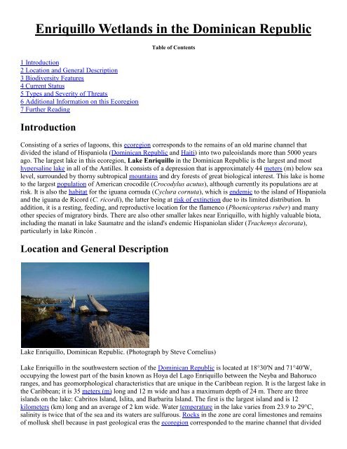
Lake <strong>Enriquillo</strong>, Dom<strong>in</strong>ican <strong>Republic</strong>. (Photograph by Steve Cornelius)<br />
Lake <strong>Enriquillo</strong> <strong>in</strong> <strong>the</strong> southwestern section of <strong>the</strong> Dom<strong>in</strong>ican <strong>Republic</strong> is located at 18°30'N and 71°40'W,<br />
occupy<strong>in</strong>g <strong>the</strong> lowest part of <strong>the</strong> bas<strong>in</strong> known as Hoya del Lago <strong>Enriquillo</strong> between <strong>the</strong> Neyba and Bahoruco<br />
ranges, and has geomorphological characteristics that are unique <strong>in</strong> <strong>the</strong> Caribbean region. It is <strong>the</strong> largest lake <strong>in</strong><br />
<strong>the</strong> Caribbean; it is 35 meters (m) long and 12 m wide and has a maximum depth of 24 m. There are three<br />
islands on <strong>the</strong> lake: Cabritos Island, Islita, and Barbarita Island. The first is <strong>the</strong> largest island and is 12<br />
kilometers (km) long and an average of 2 km wide. Water temperature <strong>in</strong> <strong>the</strong> lake varies from 23.9 to 29°C,<br />
sal<strong>in</strong>ity is twice that of <strong>the</strong> sea and its waters are sulfurous. Rocks <strong>in</strong> <strong>the</strong> zone are coral limestones and rema<strong>in</strong>s<br />
of mollusk shell because <strong>in</strong> past geological eras <strong>the</strong> ecoregion corresponded to <strong>the</strong> mar<strong>in</strong>e channel that divided
<strong>the</strong> island of Hispaniola <strong>in</strong>to two paleoislands. Annual precipitation <strong>in</strong> this ecoregion is between 400 and 500<br />
millimeters (mm), represent<strong>in</strong>g one of <strong>the</strong> most arid areas on <strong>the</strong> island. The lake is fed by subterranean and<br />
surface <strong>in</strong>fluents, but its volume only <strong>in</strong>creases significantly with <strong>the</strong> hurricanes, cyclones, and tropical storms<br />
that lash <strong>the</strong> island. In <strong>the</strong> Dom<strong>in</strong>ican <strong>Republic</strong>, o<strong>the</strong>r less important lakes with orig<strong>in</strong>s similar to those of Lake<br />
<strong>Enriquillo</strong> are R<strong>in</strong>cón Lagoon (Cristóbal or Cabral), Lake Caballero. R<strong>in</strong>cón Lagoon is 47 square kilometers<br />
(km 2 ) and is <strong>the</strong> largest body of fresh water <strong>in</strong> <strong>the</strong> Dom<strong>in</strong>ican <strong>Republic</strong>. In Haiti, Saumatre Lagoon (Étang<br />
Saumatre or Lago Azuei) is <strong>the</strong> country's largest lake. It occupies ano<strong>the</strong>r concavity 10 km west of Lake<br />
<strong>Enriquillo</strong>, separated from it by <strong>the</strong> Jimaní anticl<strong>in</strong>e. It covers an area of approximately 120 km 2 and is located<br />
<strong>in</strong> <strong>the</strong> far east of <strong>the</strong> Cul-de-sac Valley. Ano<strong>the</strong>r smaller lake on <strong>the</strong> Haitian coast and close to Saumatre is Trou<br />
Cayman, measur<strong>in</strong>g approximately 15 km 2 .<br />
The shores of Lake <strong>Enriquillo</strong>, as well as <strong>the</strong> three islands on <strong>the</strong> lake and <strong>the</strong> smaller lagoons, have dry<br />
subtropical forest and subtropical thorny mounta<strong>in</strong> that is very valuable because it has some species with very<br />
restricted distributions. Vegetation consists primarily of bayahonda (Prosopis juliflora), cambrón (Acacia<br />
macracantha), guayacán (Guaiacum offic<strong>in</strong>ale), almácigo (Bursera simarouba), baitoa (Phyllostylon<br />
brasiliensis), and sp<strong>in</strong>y shrubs (cactáceas) such as <strong>the</strong> guazábara (Cyl<strong>in</strong>dropuntia caribaea), cayucos<br />
(Pilosocereus polygonus), melón esp<strong>in</strong>oso (Melocactus lemairei), alpargata (Opuntia moniliformes) and<br />
bombillito (Neomammillaria prolifera) . Common palm trees are <strong>the</strong> yarey (Copernicia berteroana) and <strong>the</strong><br />
palma cacheo (Pseudophoenix v<strong>in</strong>ifera). In <strong>the</strong> wetter areas <strong>the</strong> baría (Callophylum calaba), copey (Clusia<br />
rosea), mangle rojo (Rhizophora mangle), and mangle botón (Conocarpus erecta) predom<strong>in</strong>ate.<br />
Biodiversity Features<br />
An <strong>in</strong>ventory of <strong>the</strong> flora on Cabritos Island shows that <strong>the</strong>re are 105 species of plants, primarily herbaceous (57<br />
species), followed by trees, cactus, shrubs, and creepers. To be noted is <strong>the</strong> limited numbers of palm and<br />
epiphyte species. More than 10% of <strong>the</strong> species on Cabritos Island are endemic to Hispaniola or <strong>the</strong> ecoregion.<br />
This habitat of subtropical dry forest and subtropical thorny montane vegetation is of great <strong>in</strong>terest due to <strong>the</strong><br />
abundance of xerophytic vegetation on <strong>the</strong> island of Hispaniola.<br />
Both land and aquatic fauna <strong>in</strong> this ecoregion are also of great biological value. In <strong>the</strong> wetter areas, we f<strong>in</strong>d<br />
amphibians like <strong>the</strong> "maco pempém" (Bufo mar<strong>in</strong>us) and endemic "bufónido" (Pelthophryne gun<strong>the</strong>ri). In drier<br />
areas, we f<strong>in</strong>d various reptiles, with two species of iguana (Cyclura spp.), 25 species of lizards (Anolis spp.,<br />
Ameiva spp., Aristelliger cochranae, and o<strong>the</strong>rs) and 13 species of snakes (Epicrates spp., Uromacer catesbyi,<br />
and o<strong>the</strong>rs). Of <strong>the</strong> two iguana species, Cyclura ricordi is critically at risk of ext<strong>in</strong>ction and lives only <strong>in</strong> this<br />
lake, <strong>in</strong> <strong>the</strong> Jaragua National Park. Also to be noted is <strong>the</strong> largest snake on Hispaniola Island is <strong>the</strong> Alsophis<br />
anomalus, which is only found <strong>in</strong> two o<strong>the</strong>r areas with <strong>in</strong>sular geography. Aquatic herpetofauna is represented<br />
by <strong>the</strong> American crocodile (Crocodylus acutus) and a turtle <strong>the</strong> Hispaniolan slider or "jicotea" (Trachemys<br />
decorata) endemic to <strong>the</strong> island; with its largest population <strong>in</strong> Lake R<strong>in</strong>cón. Current populations of American<br />
crocodile on <strong>the</strong> island of Hispaniola are only found on Lake <strong>Enriquillo</strong>, Manzanillo Bay, and Lake Saumatre<br />
(Haiti) and Lake <strong>Enriquillo</strong> has <strong>the</strong> largest natural population <strong>in</strong> <strong>the</strong> world (estimated population of 400).<br />
Aquatic fauna is also represented by tilapia and o<strong>the</strong>r fish.<br />
Of <strong>the</strong> 35 species of land birds reported, <strong>the</strong> most representative are <strong>the</strong> broad-billed tody (Tordus subulatos),<br />
burrow<strong>in</strong>g owl, "cucú" (A<strong>the</strong>ne cunicularia), palm crow, "cao" (Corvus palmarum), and verva<strong>in</strong> humm<strong>in</strong>gbird<br />
(Mellisuga m<strong>in</strong>ima). Of <strong>the</strong> 62 species of aquatic birds, many of <strong>the</strong>m migratory, we mention <strong>the</strong> p<strong>in</strong>k<br />
flam<strong>in</strong>goes (Phoenicopterus ruber), roseate spoonbill (Ajaia ajaja), green-backed heron (Butorides striatus),<br />
little blue heron (Egretta caerulea), tricoloured heron (Hydranassa tricolor) and Bahama p<strong>in</strong>tail (Anas<br />
bahamensis). Land mammals are represented by <strong>the</strong> greater bulldog bat (Noctilio lepor<strong>in</strong>us) and Mexican freetailed<br />
bat (Tadarida brasiliensis). It is important to emphasize <strong>the</strong> presence of sea cows or manatees<br />
(Trichechus manatus) <strong>in</strong> Lake Saumatre.
Hurricanes and tropical storms can be beneficial to <strong>the</strong> lakes because <strong>the</strong>y replenish <strong>the</strong>m with freshwater.<br />
Current Status<br />
This ecoregion is outstand<strong>in</strong>g <strong>in</strong> regional terms, with a vulnerable conservation status and maximum<br />
conservation priority (I). There is sufficient taxonomic and geographic data on <strong>the</strong> ecoregion to implement an<br />
appropriate conservation strategy. The succulent vegetation endemic to this area is very vulnerable to human<br />
activities and is thus a plant community at risk.<br />
There are three National Parks <strong>in</strong> <strong>the</strong> ecoregion with IUCN management category II, all of <strong>the</strong>m on <strong>the</strong><br />
Dom<strong>in</strong>ican Coast. In 1974, <strong>the</strong> Cabritos Island National Park was created with an area of 26 km 2 . In 1995, <strong>the</strong><br />
<strong>Enriquillo</strong> Lake National Park was created with 320 km 2 , and <strong>in</strong> 1997 R<strong>in</strong>cón Lagoon's category was changed<br />
from Wildlife Refuge to National Park, <strong>in</strong>creas<strong>in</strong>g <strong>the</strong> protected area of <strong>the</strong> park to 240 km 2 .<br />
Types and Severity of Threats<br />
One of <strong>the</strong> most significant threats to Lake <strong>Enriquillo</strong> is its high sal<strong>in</strong>ity at certa<strong>in</strong> times of year as a result of <strong>the</strong><br />
divert<strong>in</strong>g of freshwater by pipes empty<strong>in</strong>g <strong>in</strong>to <strong>the</strong> lake for use <strong>in</strong> <strong>the</strong> area's agriculture. Ano<strong>the</strong>r threat,<br />
particularly to crocodiles, is <strong>in</strong>discrim<strong>in</strong>ate hunt<strong>in</strong>g as well as altered habitat due to reduced vegetation. Also<br />
detrimental is <strong>the</strong> drill<strong>in</strong>g of tubular wells <strong>in</strong> communities close to <strong>the</strong> lake, graz<strong>in</strong>g of livestock, and ga<strong>the</strong>r<strong>in</strong>g<br />
of firewood. The most press<strong>in</strong>g causes of <strong>the</strong> degradation of Lake Saumatre and its surround<strong>in</strong>gs <strong>in</strong>volve <strong>the</strong><br />
<strong>in</strong>flow of human and animal waste, sediments com<strong>in</strong>g from mounta<strong>in</strong> ra<strong>in</strong>s, contam<strong>in</strong>ation from detergents and<br />
o<strong>the</strong>r chemicals and <strong>the</strong> burn<strong>in</strong>g of trees. Insular ecosystems are very fragile and once altered it is difficult for<br />
<strong>the</strong>m to revert to <strong>the</strong>ir orig<strong>in</strong>al state.<br />
Additional Information on this Ecoregion<br />
For a shorter summary of this entry, see <strong>the</strong> WWF WildWorld profile of this ecoregion.<br />
Fur<strong>the</strong>r Read<strong>in</strong>g<br />
Amezqueta, J., J.P. Pujas, L.E. Pérez, J. Alarcón, L. Valdez, and E. Bautista, 1987. Aspectos generales<br />
sobre el cocodrilo americano. Santo Dom<strong>in</strong>go, República Dom<strong>in</strong>icana.<br />
Caribbean Environmental Programme (CEP) 1996. Status of Protected Area Systems <strong>in</strong> <strong>the</strong> Wider<br />
Caribbean Region. CEP Technical Report No. 36<br />
D<strong>in</strong>erste<strong>in</strong>, E., D.M. Olson, D.L. Graham., A.L. Webster, S.A. Primm, M.P. Bookb<strong>in</strong>der, and G. Ledec.<br />
1995. A Conservation Assessment of <strong>the</strong> Terrestrial Ecoregions of Lat<strong>in</strong> America and <strong>the</strong> Caribbean.<br />
The World Bank. ISBN: 0821332961<br />
DNP 1989. Los parques nacionales de la República Dom<strong>in</strong>icana. Dirección Nacional de Parques, Santo<br />
Dom<strong>in</strong>go, RD.<br />
Hartshorn, G., G. Anton<strong>in</strong>i, and R. DuBois. 1981. La República Dom<strong>in</strong>icana. Pefil ambiental del país.<br />
Un estudio de Campo. JRB Associates, Virg<strong>in</strong>ia, USA.<br />
Hernández, C. y J. Czerwenka, 1986. Contribuciones para un nuevo concepto de conservación en el área<br />
del Lago <strong>Enriquillo</strong>. Secretaría de Estado de Agricultura, Departamento de Vida Silvestre. Santo<br />
Dom<strong>in</strong>go, R.D.<br />
IUCN, 1982. IUCN directory of Neotropical Protected Areas. ISBN: 0907567630<br />
Marcano, E. J., 1987. Flórula de la Isla Cabritos.<br />
Marcano, J. (n.d). Suroeste Dom<strong>in</strong>icano.<br />
Moreta, A. n.d. El lago <strong>Enriquillo</strong> aumenta su caudal con el agua de los ciclones y tormentas tropicales<br />
que azotan el país. El Siglo.
Narpier, R. n.d.. Flora, fauna y belleza del Lago <strong>Enriquillo</strong>. El Siglo.<br />
OAS. 1984. Écologie, Republique d'Haiti. Map 1:500,000. Organization of American States,<br />
Wash<strong>in</strong>gton, D.C., USA<br />
Octave, F. 1999. Lake Azuei: An important resource <strong>in</strong> Haiti be<strong>in</strong>g wasted. Island beat: News from <strong>the</strong><br />
Environmental Frontl<strong>in</strong>e of <strong>the</strong> Caribbean. The Panos Institute of <strong>the</strong> Caribbean.<br />
Oldfield, S. (comp.), 1997. Cactus and Suculent Plants. IUCN/SCC Cacuts and Succulent Specialist<br />
Group. Gland, Switzerland.<br />
Olson, D., E. D<strong>in</strong>erste<strong>in</strong>, G. Castro, and E. Maravi. 1996. Identify<strong>in</strong>g gaps <strong>in</strong> botanical <strong>in</strong>fromation for<br />
biodiversity conservation <strong>in</strong> Lat<strong>in</strong> America and <strong>the</strong> Caribbean. World Wildlife Fund, Wash<strong>in</strong>gton, D.C.,<br />
USA.<br />
SEA/DVS 1990. La diversidad biológica en la República Dom<strong>in</strong>icana. Reporte preparado por el<br />
Departamento de Vida Silvestre para el Servicio de Cooperación Social-Técnica y WWF-US. Secretaría<br />
de Estado de Agricultura, SURENA/DVS, Santo Dom<strong>in</strong>go, RD.<br />
SEA/DVS 1995. Mejoramiento de la Situación Ambiental en la Propuesta Reserva de Biosfera<br />
"<strong>Enriquillo</strong>", Tomo 2. Santo Dom<strong>in</strong>go, R.D.<br />
Tasaico, H. 1967. Mapa ecologico de la <strong>Republic</strong>a Dom<strong>in</strong>icana. Unidad de Recursos Naturales de la<br />
Union Panamericana.<br />
UNEP-WCMC. Protected Areas Programme. Parks, Protected Areas, and World Heritage.<br />
Valdez, G. y M. Mateo. 1992. Sistema de áreas protegidas de la República Dom<strong>in</strong>icana. Dirección<br />
Nacional de Parques, Santo Dom<strong>in</strong>go, RD.<br />
Disclaimer: This article conta<strong>in</strong>s <strong>in</strong>formation that was orig<strong>in</strong>ally published by <strong>the</strong> World Wildlife Fund. Topic editors and authors for <strong>the</strong> Encyclopedia of Earth have edited its content and added new<br />
<strong>in</strong>formation. The use of <strong>in</strong>formation from <strong>the</strong> World Wildlife Fund should not be construed as support for or endorsement by that organization for any new <strong>in</strong>formation added by EoE personnel, or for<br />
any edit<strong>in</strong>g of <strong>the</strong> orig<strong>in</strong>al content.<br />
Citation<br />
World Wildlife Fund (Lead Author);Mark McG<strong>in</strong>ley, C Michael Hogan (Topic Editor) "<strong>Enriquillo</strong> wetlands".<br />
In: Encyclopedia of Earth. Eds. Cutler J. Cleveland (Wash<strong>in</strong>gton, D.C.: Environmental Information Coalition,<br />
National Council for Science and <strong>the</strong> Environment). [First published <strong>in</strong> <strong>the</strong> Encyclopedia of Earth May 9, 2009;<br />
Last revised Date October 6, 2011; Retrieved July 10, 2012<br />