

Converting the Soil Map of Belgium into the WRB
Converting the Soil Map of Belgium into the WRB
Converting the Soil Map of Belgium into the WRB

You also want an ePaper? Increase the reach of your titles
YUMPU automatically turns print PDFs into web optimized ePapers that Google loves.
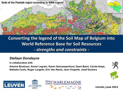
<strong>Converting</strong> <strong>the</strong> legend <strong>of</strong> <strong>the</strong> <strong>Soil</strong> <strong>Map</strong> <strong>of</strong> <strong>Belgium</strong> <strong>into</strong><br />
World Reference Base for <strong>Soil</strong> Resources<br />
- strengths and constraints -<br />
Stefaan Dondeyne<br />
in collaboration with<br />
Antoine Bouhoun, Xavier Legrain, Karen Vancampenhout, Geert Baert, Carole Ampe,<br />
Nathalie Cools, Roger Langohr, Eric Van Ranst, Jean Chapelle, Jozef Deckers<br />
Lincoln, June 2012
Outline<br />
• Background and Objectives<br />
• Legend <strong>of</strong> <strong>the</strong> <strong>Soil</strong> <strong>Map</strong> <strong>of</strong> <strong>Belgium</strong><br />
• Examples <strong>of</strong> conversion<br />
• Examples <strong>of</strong> legends according to <strong>WRB</strong><br />
• Discussion and conclusion
Background and objectives<br />
• In Europe soil mapping was done according to different<br />
National Classification Systems<br />
• For EU policies: need to correlate and harmonise soil maps
• Developed a method to convert <strong>the</strong> legend <strong>of</strong> <strong>the</strong> <strong>Soil</strong> <strong>Map</strong><br />
<strong>of</strong> <strong>Belgium</strong> <strong>into</strong> <strong>the</strong> <strong>WRB</strong> (<strong>WRB</strong>-2007)<br />
• Test this in three case study areas on a 1:20,000 scale (<strong>the</strong><br />
original maps)<br />
Background and objectives<br />
• Assessed how this can be used for a small scale map<br />
(1:250,000) for <strong>the</strong> Flemish region (nor<strong>the</strong>rn part)
Legend <strong>of</strong> <strong>Soil</strong> <strong>Map</strong> <strong>of</strong> <strong>Belgium</strong><br />
Belgian <strong>Soil</strong> Survey project<br />
1947 – 1991<br />
• ~ 15,000 pr<strong>of</strong>iles described (1 per 2 km²),<br />
with analytical data <strong>of</strong> about 80,000 horizons<br />
• ~ 1 or 2 soil augering per hectare
1: 20,000 scale<br />
Legend <strong>of</strong> <strong>Soil</strong> <strong>Map</strong> <strong>of</strong> <strong>Belgium</strong>
Legend <strong>of</strong> <strong>Soil</strong> <strong>Map</strong> <strong>of</strong> <strong>Belgium</strong>
Legend <strong>of</strong> <strong>Soil</strong> <strong>Map</strong> <strong>of</strong> <strong>Belgium</strong><br />
w A h a 1
Legend <strong>of</strong> <strong>Soil</strong> <strong>Map</strong> <strong>of</strong> <strong>Belgium</strong><br />
w A h a 1
Translation key<br />
L.. ~ silt loam<br />
.h. stagnic<br />
properties<br />
..c strongly<br />
“mottled”<br />
Bt horizon<br />
Example <strong>of</strong> Unequivocal conversion<br />
<strong>WRB</strong>: Stagnic Cutanic Albeluvisol<br />
(Siltic)
..m = deep anthropogenic surface horizon<br />
Zbm<br />
<strong>WRB</strong>: Plaggic Anthrosol (Arenic)<br />
Zdm<br />
Example <strong>of</strong> not an<br />
Unequivocal conversion<br />
Endogleyic Terric Anthrosol (Arenic)
..m = deep anthropogenic surface horizon<br />
Zbm<br />
<strong>WRB</strong>: Plaggic Anthrosol (Arenic)<br />
Zdm<br />
Example <strong>of</strong> not an<br />
Unequivocal conversion<br />
Endogleyic Terric Anthrosol (Arenic)
Case study in silt-loam region Legend according to <strong>WRB</strong><br />
Nudiargic Luvisol Colluvic Cambisol/Regosol<br />
Colluvic Luvisol<br />
(sheet 103w Duisburg)<br />
Eutric Fluvisol and Fluvic Cambisol<br />
Nudiargic Luvisol with<br />
Calcaric Cambisol/Regosol
Case study in sandy region<br />
Reference <strong>Soil</strong> Groups as first entry and<br />
determining <strong>the</strong> colour<br />
Coming from 207 mapping units in original map<br />
- 10 units at RSG level<br />
- 37 units when including <strong>the</strong> qualifiers<br />
Legend according to <strong>WRB</strong><br />
Legend qualifiers limited to one or two<br />
- which can be inferred from <strong>the</strong> original legend<br />
- which are meaningful for land management
Scale<br />
1:250,000<br />
• Main qualifiers – clear morphologic features<br />
• Drainage qualifiers, separate (“GIS logic”)<br />
• idem “Abruptic/Ruptic”<br />
• Information on texture separate according<br />
to National system
Discussion and conclusions<br />
Legend <strong>of</strong> soil map <strong>of</strong> <strong>Belgium</strong><br />
• Belgian mapping units, very detailed information which <strong>of</strong>ten has no<br />
correspondence in <strong>WRB</strong> - particularly in terms <strong>of</strong> texture, substratum<br />
and drainage (we end up with lots <strong>of</strong> “Endogleyic”)<br />
• “Automatic” conversion is not possible; need to take local context <strong>into</strong><br />
account.<br />
Legend according to <strong>WRB</strong><br />
• Conversion leads to maps with less information, but better<br />
“readable” - for being “simpler” and in an “international language”<br />
• Form a good base for generalising to smaller scale maps<br />
• <strong>WRB</strong>, having a limited hierarchy, presents a great degree <strong>of</strong><br />
flexibility which allows representing our current soil information<br />
conveniently in an internationally understandable legend.
Thanks for your attention<br />
Stefaan.Dondeyne@ees.kuleuven.be<br />
More at<br />
https://lirias.kuleuven.be/handle/123456789/346645


