Cadron Settlement Cemetery(pt5) - ARGenWeb
Cadron Settlement Cemetery(pt5) - ARGenWeb
Cadron Settlement Cemetery(pt5) - ARGenWeb

Create successful ePaper yourself
Turn your PDF publications into a flip-book with our unique Google optimized e-Paper software.
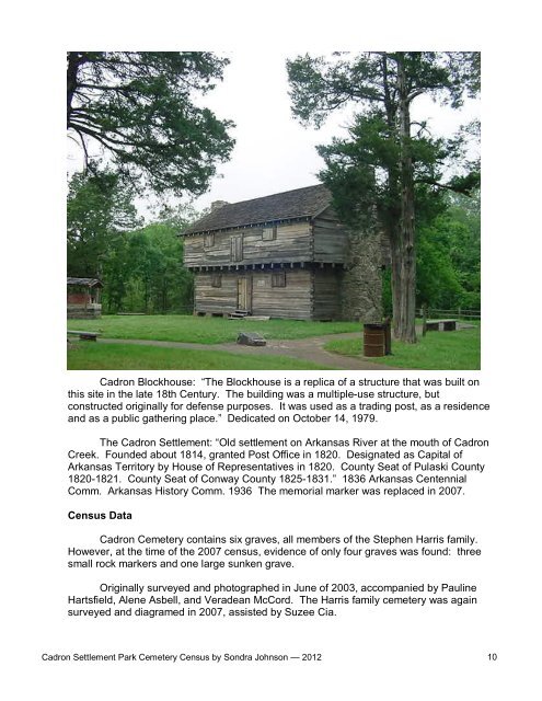
<strong>Cadron</strong> Blockhouse: “The Blockhouse is a replica of a structure that was built on<br />
this site in the late 18th Century. The building was a multiple-use structure, but<br />
constructed originally for defense purposes. It was used as a trading post, as a residence<br />
and as a public gathering place.” Dedicated on October 14, 1979.<br />
The <strong>Cadron</strong> <strong>Settlement</strong>: “Old settlement on Arkansas River at the mouth of <strong>Cadron</strong><br />
Creek. Founded about 1814, granted Post Office in 1820. Designated as Capital of<br />
Arkansas Territory by House of Representatives in 1820. County Seat of Pulaski County<br />
1820-1821. County Seat of Conway County 1825-1831.” 1836 Arkansas Centennial<br />
Comm. Arkansas History Comm. 1936 The memorial marker was replaced in 2007.<br />
Census Data<br />
<strong>Cadron</strong> <strong>Cemetery</strong> contains six graves, all members of the Stephen Harris family.<br />
However, at the time of the 2007 census, evidence of only four graves was found: three<br />
small rock markers and one large sunken grave.<br />
Originally surveyed and photographed in June of 2003, accompanied by Pauline<br />
Hartsfield, Alene Asbell, and Veradean McCord. The Harris family cemetery was again<br />
surveyed and diagramed in 2007, assisted by Suzee Cia.<br />
<strong>Cadron</strong> <strong>Settlement</strong> Park <strong>Cemetery</strong> Census by Sondra Johnson — 2012 10
Arkansas<br />
River<br />
Old Federal Historical Marker<br />
<strong>Cadron</strong> <strong>Settlement</strong> Park <strong>Cemetery</strong> Census by Sondra Johnson — 2012 11
Driving Directions: From Conway, at the junction of Highway 64 and Highway 25,<br />
drive west on the old Morrilton Highway (Highway 64) approximately 4-1/2 miles. Turn<br />
left (south) on Highway 319 and drive 1-1/2 miles to <strong>Cadron</strong> <strong>Settlement</strong> Park. Park and<br />
walk up the well-defined path north of the main pavilion to the cemetery.<br />
<strong>Cadron</strong> <strong>Settlement</strong> Park <strong>Cemetery</strong> Census by Sondra Johnson — 2012 12