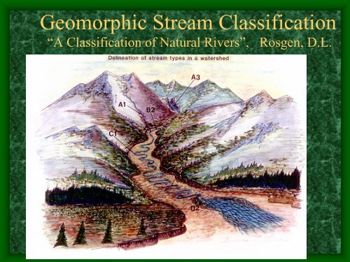
Geomorphic Stream Classification - The Jornada
Geomorphic Stream Classification - The Jornada
Geomorphic Stream Classification - The Jornada

You also want an ePaper? Increase the reach of your titles
YUMPU automatically turns print PDFs into web optimized ePapers that Google loves.
<strong>Geomorphic</strong> <strong>Stream</strong> <strong>Classification</strong><br />
“A <strong>Classification</strong> of Natural Rivers”, Rosgen, D.L.
Why is <strong>Stream</strong> <strong>Classification</strong><br />
• Physical stream channel<br />
evolution<br />
Essential?<br />
•Similar stream types manifest<br />
similar patterns<br />
• Natural channel design<br />
• Planning and management<br />
• Riverine habitats, plants and<br />
animals are constrained by<br />
natural channel physics<br />
Napeequa River
A stream is a portion of a fluvial system<br />
<strong>Stream</strong> Corridor Restoration: Principles, Processes, and Practices, 1998<br />
We need a greater resolution on the landscape<br />
based on morphometry. It must be<br />
reproducible and measurable. We can<br />
communicate about a relatively complex<br />
description in relatively simple terms.
<strong>Classification</strong> Level 1
Rosgen (1994)<br />
<strong>Classification</strong> Level II<br />
<strong>Stream</strong> Corridor Restoration: Principles, Processes, and Practices, 1998
Entrenchment Ratio
What are the dimensionless ratios for the stable form<br />
relative to the specific reach of interest?<br />
C Channels<br />
B Channels<br />
A Channels<br />
Wildland Hydrology, 1998 – modified 2006
Distinct Morphology by <strong>Stream</strong> Type<br />
(i.e, meander belt width)
We need to answer these<br />
concerns<br />
Are we comparing apples to apples ?(94 basic<br />
geomorphic stream types.)<br />
Dimensions applied in stream design are not<br />
regionalized.<br />
Database and stream design dimensions are<br />
lacking.
A1a Morphology<br />
A1a Trib. to Uncampaghre<br />
Valley Type I, Youthful Topography
A2 - Yelm, WA<br />
Valley Type I, Source
A2a on Mission Falls
A3a <strong>Stream</strong> Morphology<br />
A3a on Uncampaghre Headwaters
A3 less than 10% Slope<br />
Cobble Bed, Highly<br />
Entrenched, Low Width to<br />
Depth Ratio, Low<br />
Sinuosity.<br />
Sometimes miss-classified<br />
as a G stream type.
A5 <strong>Stream</strong> Type
Valley Types and <strong>Stream</strong><br />
A <strong>Stream</strong>s<br />
B <strong>Stream</strong>s<br />
C and D<br />
streams,<br />
high<br />
gradient<br />
C, E, D, F, Gc<br />
<strong>Classification</strong><br />
Type I<br />
Type VI, fault control<br />
Type V Early Mature<br />
Type VIII, Mature
<strong>Geomorphic</strong> Valley Types<br />
Youthful<br />
Wildland Hydrology, 1996<br />
Early Mature<br />
Old Age<br />
Wildland Hydrology, 1996<br />
Wildland Hydrology, 1996<br />
What do<br />
William Morris<br />
Davis (1899)<br />
and Dave<br />
Rosgen have<br />
in common?<br />
Old Age<br />
Wildland Hydrology, 1996
B1 Morphology B Morphology<br />
•Single Threaded<br />
•Entrenchment 1.4 – 2.2<br />
•Width to depth Ratio > 12<br />
•Sinuosity > 1.2<br />
•Slope 2 to 4%<br />
•B_a Slope range 4 to 10%<br />
•B_c Slope less than 2%
B2<br />
Morphology<br />
B2c with a slope<br />
less than 2%<br />
(0.002ft/ft)
B2 Step:Pool Morphology
B3 Morphology<br />
Cobble Bed
B stream Type in<br />
Valley Type II<br />
Young Valleys<br />
Valley Type II
B4<br />
Slope 2-4%<br />
B4c is very<br />
common<br />
Slope < 2%
Often may have numerous cobbles present but<br />
D50 < 64mm<br />
B4
B5-Sand<br />
Very Sensitive to<br />
Disturbance
B6<br />
Not very<br />
common<br />
but present<br />
in steep<br />
loess<br />
country
B6 forming on<br />
Palouse<br />
Not Common
C <strong>Stream</strong> Type<br />
Morphology<br />
Classic Pool:Riffle<br />
Morphology<br />
Well-Attached<br />
Floodplain<br />
C3, C4, and C5 are<br />
some of the most<br />
common stream types
Valley Type VIII<br />
Multiple Terraces<br />
Common valleys for C type streams, sometime Es. However, D, F,<br />
and G types can be found depending on stream and riparian<br />
conditions
C Morphology<br />
Single and thread channel<br />
Entrenchment Ratio > 2.2<br />
Width:Depth Ratio > 12<br />
Bankfull Elevation<br />
Sinuosity > 1.2<br />
Slope, 0.01 to 2%<br />
C_b slope 2-4%<br />
C_c- slopes < 0.1%<br />
C4
C Morphology Restored
C1<br />
Bedrock control<br />
cobbles and<br />
boulders present<br />
Not a common<br />
type
C4 Current Stable Analog-North Cascades
<strong>The</strong> C4 <strong>Stream</strong> Type is a<br />
Key <strong>Stream</strong> Type for<br />
Salmonids.
C4 Morphology, very common,<br />
very important on the landscape
C5 Sand Bed
C6 Morphology<br />
Usually very<br />
gentle slopes<br />
often associated<br />
with lacustrine<br />
valley<br />
development
D4 Braided
Braided (DA_)<br />
Anastomosed<br />
Mature natural stable type<br />
braided stream with<br />
multiple low width to<br />
depth ratio channels, most<br />
highly biologically<br />
productive per linear<br />
stream distance. Often<br />
found in estuaries,<br />
lacustrine bed very flat<br />
valleys and outlets to<br />
lakes
Stehekin<br />
Anastomosed<br />
Braided<br />
Anastomosed<br />
Is your river an<br />
anastomosed braided<br />
system or in a highly<br />
perturbed braided<br />
condition?<br />
Braided<br />
Aggraded
E Channel Morphology(at bankfull)<br />
Upper Sanpoil River, WA, ER = 19, Average Depth 3.1 feet<br />
Average Width 16, Average slope 0.002 ft/ft, Valley type X<br />
E4
E Channel Morphology<br />
Single Thread channel<br />
Entrenchment Ratio > 2.2<br />
Width to Depth Ratio < 12<br />
Sinuosity > 1.5<br />
Slope < 2%<br />
E_b, Slope ranges 2-4%, not<br />
common
Valley Type X: Often E or C
E4 <strong>Stream</strong> Type
E3 Channels<br />
Not Common<br />
but present in<br />
high mountain<br />
meadows
E4 <strong>Stream</strong> Type
E5, Sand Bed
F Channel Morphology<br />
Highly Entrenched >1.4<br />
High Width to Depth<br />
Ratio > 12<br />
Sinuosity > 1.2<br />
Slopes < 2.0% (0.02ft/ft)<br />
F_b Slopes, 2 to 4%
Crab Creek<br />
F4
G <strong>Stream</strong> Types<br />
Entrenchment Ratio < 1.4<br />
Width Depth Ratio < 12<br />
Sinuosity > 1.2<br />
Slope, 2-4%<br />
G_c Slopes < 2% Common on Ag.<br />
Landscape, Schumm Stage II, Rapid<br />
Channel adjustment<br />
Floodplain<br />
Floodplain<br />
G3<br />
Swan Creek, WA
Before and After<br />
Six years and two large floods later
Channel Change Adjustments and Evolution
Five years<br />
Later<br />
1997
Schumm, Harvey, Watson (1984):<br />
I<br />
II<br />
III<br />
IV<br />
V<br />
Stable<br />
Incision<br />
Widening<br />
Channel Evolution Model<br />
Stable<br />
Floodplain<br />
Q 1.5<br />
Q 10<br />
Terrace<br />
Floodplain<br />
+Q 10<br />
+Q 10<br />
Q 1.5<br />
= Bankfull Q<br />
Terrace 1<br />
(Headcutting)<br />
(Bank Failure)<br />
Stabilizing<br />
/Deposition<br />
Terrace 1<br />
Modified by W. Barry<br />
Southerland, 2003
Schumm<br />
Channel<br />
Evolution<br />
Model and<br />
Bank Height<br />
Ratio (BHR)<br />
Floodplain Abandonment<br />
Stage I<br />
WBS, 2002<br />
Stage II<br />
WBS, 2002<br />
Stage I<br />
WBS, 2002<br />
BHR = Top of the<br />
Bank / Bankfull<br />
Height. This is a<br />
measure of the<br />
degree of incision
Bank height ratio<br />
This variable is a<br />
field<br />
measurement<br />
that determines<br />
the degree of<br />
channel incision.<br />
It is calculated<br />
by dividing the<br />
maximum<br />
bankfull depth<br />
into the height of<br />
the lowest bank.
Why BHR?<br />
BHR ~ 1.05<br />
Sanpoil <strong>Stream</strong><br />
BHR > 1.2,<br />
early incision<br />
begins to<br />
show impacts<br />
Wenas <strong>Stream</strong><br />
Bankfull
Slight entrenchment but with meander confinement,<br />
Schumm Stage V – E4 Channel<br />
Bankfull<br />
Indicators
Aquatic Habitat Response to <strong>Stream</strong> Type Change
Pot. Treat. Opt. Low Banks (
Pot. Treat. Options Low Banks (
Pot. Treat. Options Low Banks (
Pot. Treat. Options Low Banks (
Pot. Treat. Options Low Banks (
Pot. Treat. Options Low Banks (
Pot. Treat. Options Low Banks (
<strong>Stream</strong>bank slope relative to structure<br />
Photo by WBS, Ohio Creek, CO, 6/2005
Thank you. Questions, please?<br />
Who’s your Mommy now?