final Sedimentation Report - City and Borough of Sitka
final Sedimentation Report - City and Borough of Sitka
final Sedimentation Report - City and Borough of Sitka

You also want an ePaper? Increase the reach of your titles
YUMPU automatically turns print PDFs into web optimized ePapers that Google loves.
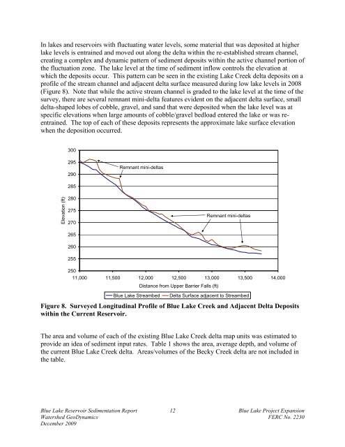
In lakes <strong>and</strong> reservoirs with fluctuating water levels, some material that was deposited at higher<br />
lake levels is entrained <strong>and</strong> moved out along the delta within the re-established stream channel,<br />
creating a complex <strong>and</strong> dynamic pattern <strong>of</strong> sediment deposits within the active channel portion <strong>of</strong><br />
the fluctuation zone. The lake level at the time <strong>of</strong> sediment inflow controls the elevation at<br />
which the deposits occur. This pattern can be seen in the existing Lake Creek delta deposits on a<br />
pr<strong>of</strong>ile <strong>of</strong> the stream channel <strong>and</strong> adjacent delta surface measured during low lake levels in 2008<br />
(Figure 8). Note that while the active stream channel is graded to the lake level at the time <strong>of</strong> the<br />
survey, there are several remnant mini-delta features evident on the adjacent delta surface, small<br />
delta-shaped lobes <strong>of</strong> cobble, gravel, <strong>and</strong> s<strong>and</strong> that were deposited when the lake level was at<br />
specific elevations when large amounts <strong>of</strong> cobble/gravel bedload entered the lake or was reentrained.<br />
The top <strong>of</strong> each <strong>of</strong> these deposits represents the approximate lake surface elevation<br />
when the deposition occurred.<br />
Elevation (ft)<br />
300<br />
295<br />
290<br />
285<br />
280<br />
275<br />
270<br />
265<br />
260<br />
255<br />
Remnant mini-deltas<br />
250<br />
11,000 11,500 12,000 12,500 13,000 13,500 14,000<br />
Distance from Upper Barrier Falls (ft)<br />
Remnant mini-deltas<br />
Blue Lake Streambed Delta Surface adjacent to Streambed<br />
Figure 8. Surveyed Longitudinal Pr<strong>of</strong>ile <strong>of</strong> Blue Lake Creek <strong>and</strong> Adjacent Delta Deposits<br />
within the Current Reservoir.<br />
The area <strong>and</strong> volume <strong>of</strong> each <strong>of</strong> the existing Blue Lake Creek delta map units was estimated to<br />
provide an idea <strong>of</strong> sediment input rates. Table 1 shows the area, average depth, <strong>and</strong> volume <strong>of</strong><br />
the current Blue Lake Creek delta. Areas/volumes <strong>of</strong> the Becky Creek delta are not included in<br />
the table.<br />
Blue Lake Reservoir <strong>Sedimentation</strong> <strong>Report</strong> 12 Blue Lake Project Expansion<br />
Watershed GeoDynamics FERC No. 2230<br />
December 2009