NEW FEMA FLOOD STUDY SHOULD CONCERN ... - Cranford.com
NEW FEMA FLOOD STUDY SHOULD CONCERN ... - Cranford.com
NEW FEMA FLOOD STUDY SHOULD CONCERN ... - Cranford.com

Create successful ePaper yourself
Turn your PDF publications into a flip-book with our unique Google optimized e-Paper software.
<strong>NEW</strong> <strong>FEMA</strong> <strong>FLOOD</strong> <strong>STUDY</strong> <strong>SHOULD</strong> <strong>CONCERN</strong> CITIZENS<br />
The Federal Emergency Management Agency (<strong>FEMA</strong>) revised the Flood Insurance Study<br />
(FIS) Report and Flood Insurance Rate Map (FIRM). Township representatives met with<br />
<strong>FEMA</strong> and then prepared a report questioning many points of the study and requested the 90<br />
day appeal period not start until our questions are answered satisfactorily. Well, on July 15,<br />
2004, the 90-day appeal period began.<br />
In June, the Township received a letter from <strong>FEMA</strong>, stating that the Township’s <strong>com</strong>ments are<br />
currently being reviewed and will be addressed. On July 6, 2004, the Township’s consultants,<br />
Hatch Mott MacDonald, at the Township Engineer’s request, urged <strong>FEMA</strong> to not publish until<br />
answers to our questions were received, and data provided so our officials could verify their<br />
study findings that the revised 100-year flood is at a significantly higher level than the old,<br />
approved Flood Insurance Study of August 16, 1982, both in terms of flow and area of<br />
inundation.<br />
The Township’s letter to <strong>FEMA</strong> stated that the impact on the Township of <strong>Cranford</strong> is<br />
substantial. The proposed flood elevations along significant segments of the Rahway River in<br />
<strong>Cranford</strong> are highly questionable. In view of the discrepancies that are readily observable<br />
without a high degree of technical evaluation (proposed delineations not following topographic<br />
contours, flood profiles not consistent with known flood marks), premature publication of this<br />
FIS is likely to decrease public confidence in the more technical aspects of the study and<br />
undermine the credibility of the final <strong>FEMA</strong> flood delineations. This would only make more<br />
work for <strong>FEMA</strong> and the Township.<br />
Well, residents of this fine <strong>com</strong>munity, the statutory 90-day clock is now ticking and cannot be<br />
extended. Any appeals have to be based on knowledge or information indicating that the<br />
proposed base flood elevations (BFEs), (in layman’s terms, this is the maximum flooding in<br />
your area), are scientifically or technically incorrect.<br />
Is this fair? How could you know or prove that the BFEs are scientifically or technically<br />
incorrect? In fact, how can the Township officials know, when they have yet to receive the<br />
requested data and answers to their earlier concerns from <strong>FEMA</strong>?<br />
There may be over 650 new properties that would be impacted by this new Flood Insurance<br />
Study (FIS) if the maps and study are approved as presented. With the Township<br />
Commissioners approval, the Engineering Department has prepared a list of these properties<br />
that would be impacted.<br />
We strongly urge you contact <strong>FEMA</strong>, your state and federal representatives and address your<br />
concerns and <strong>com</strong>ments about this new Flood Insurance Study (FIS). (Contact address listed<br />
below.) These revised flood elevations may put your property in the flood plain and may result<br />
in you having to obtain flood insurance or pay more for flood insurance. Please provide the<br />
Township Engineering Department a copy of your correspondence, so that we can also develop<br />
a record.
A list of the new properties that may be impacted by this new Flood Insurance Study, by street<br />
numbers, are listed below. A map of the preliminary added flood zones is on display at the<br />
Township Municipal Building, 8 Springfield Avenue, for your review, along with a more<br />
detailed report of this article.<br />
Your Township officials are also working on this, and as of July 26, 2004, we have not<br />
received any answers to our concerns. These concerns will also be posted with the maps for<br />
your review. If you have any questions specifically for the Township Engineering Department,<br />
please send a letter to Mr. Marsden or e-mail him at R-Marsden@<strong>Cranford</strong>NJ.org. Please<br />
identify the subject as New <strong>FEMA</strong> Flood Study Concerns. The Engineering Department<br />
would love to talk to you. However, we are quite busy, and would prefer a letter or e-mail.<br />
Thank you for your time and patience in this matter.<br />
<strong>FEMA</strong> CONTACTS:<br />
Michael Dabney, Director<br />
Federal Insurance and Mitigation Division of <strong>FEMA</strong><br />
U.S. Department of Homeland Security<br />
26 Federal Plaza, Room 1337<br />
New York, New York 10278<br />
Or <strong>FEMA</strong> Map Assistance Center (877) 336-2027<br />
N.J. 108 th CONGRESS CONTACTS:<br />
Richard A. Marsden, Jr., PE, PP, PLS<br />
Township Engineer<br />
Senators: The Honorable Jon Corzine<br />
Gateway One, 11 th Floor<br />
Newark, NJ 07102 (973) 645-3030<br />
7 th District Representative:<br />
The Honorable Frank Lautenberg<br />
1 Gateway Center, 23 rd Floor<br />
Newark, NJ 07102 (973) 639-8700<br />
The Honorable Michael A. Ferguson<br />
N.J. District Office<br />
792 Chimney Rock Road<br />
Martinsville, NJ 08836 (908) 757-7835
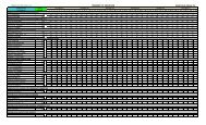
LIST OF PROPERTIES IMPACTED<br />
Baldwin Ct.: #2<br />
Bargos Pl.: #5<br />
Belmont Ave.: #101<br />
Berkeley Pl.: #3-6<br />
Blake Ave.: #3, 5, 31, 33, 35, 37, 39<br />
Brookdale Pl.: #32, 34, 36, 42-47<br />
Brookside Pl.: #715, 720<br />
Brown Ter.: #2, 4, 6, 8, 10, 12, 14, 16, 18<br />
Burnside Ave.: #32, 34, 36, 38, 40, 42, 44, 46, 48, 50, 56<br />
Casino Ave..: #307-312, 316, 317, 320, 406<br />
Central Ave.: #102, 104, 211, 215, 217, 219, 306, 308, 402, 404, 406, 408, 500-502, 504, 506,<br />
507, 509, 511<br />
Claremont Pl.: 114, 207, 209, 211, 214, 400, 402<br />
Columbia Ave.: #9, 11, 15, 17, 21, 23, 24, 26, 28, 30-38, 100-102, 104<br />
County Park Dr., #109, 111, 115, 117, 119, 121, 123, 125, 127<br />
Craig Pl.: #3-5, 7-9, 11, 12, 16, 20, 24, 27-29, 32, 33, 36, 37, 40, 41<br />
Doering Way: #1-6, 8<br />
Dunham Ave., #11, 15, 17, 17A, 19, 21, 24, 25, 27, 28, 30-32\<br />
Eastman St.: #145, 149<br />
Edgewood Rd., #113, 115<br />
Elmora Ave., #6, 31, 100-112, 115, 1l7<br />
Forest Ave.: #11, 15, 101, 103, 105, 109, 111, 117<br />
Frazer Pl.: #1, 4, 7, 9, 10, 12, 14<br />
Hamilton Ave.: #1-A<br />
Hampton Rd.: #7, 9, 21<br />
Hampton St.: #1, 5, 6, 9, 11, 13, 15, 19, 101, 103, 109, 209, 211<br />
Harvard Rd.: #1, 3, 5, 7, 9-12, 15, 17-19, 36, 38<br />
Henley Ave.: #31, 33, 35, 37, 45, 49<br />
Herning Ave.: #1, 3-30, 33-40, 100-130, 132<br />
Holly St. W.: #2-7, 9, 11-14, 19-21, 23, 25, 27-34, 36, 38, 101, 109, 111, 115, 203, 207, 209,<br />
211, 215, 217, 219<br />
Johnson Ave.: 43-54, 57, 79, 81, 83<br />
Kenilworth Blvd.: #96, 98, 100, 102, 104, 106, 108, 110, 112, 114, 116, 118, 120<br />
Lafayette Pl.: #102<br />
LaSalle Ave.: #1-23<br />
Lincoln Ave. E.: 310, 312, 314, 316<br />
Linden Pl.: #601, 605, 724, 725, 728<br />
Locust Dr.: #20-25, 27, 173, 175, 177<br />
Manor Ave.: #209, 211, 299, 301-318, 320-322, 324-333, 400, 401<br />
Maple Pl.: #104, 105, 109, 201, 303-305<br />
Munsee Dr.: #7, 9, 11, 13, 15, 17, 19, 21, 23, 25, 27, 29, 31, 33, 35, 37, 39, 41, 43<br />
Nomahegan Ct.: #2-4, 6, 8, 10, 12, 14, 16, 18<br />
Normandie Pl.: #2, 60, 64<br />
North Ave. E.: #39-45, 184, 186, 190 (1A, 1B, 2, 3), 192, 194, 198
Oak Lane: #1-24, 100-107, 109, 111, 113<br />
Orange Ave.: #7, 9, 101-116, 204, 206, 208, 210, 219, 301, 303, 305-308, 409, 411, 417, 419<br />
Orchard St.: #9, 11, 201, 207, 215, 221, 222, 225<br />
Pawnee Rd.: #102<br />
Penn Rd.: #4, 10, 12, 14, 16, 18<br />
Pine St.: #1, 2, 3<br />
Pittsfield St.: #4, 6, 8, 11, 13, 20, 26<br />
Prospect Ave.: #200, 202, 204, 206, 208, 210, 217<br />
Richmond Ave.: #38, 40, 42, 44, 46<br />
Ridge St.: #102, 104, 106, 108-116<br />
Riverside Dr.: #4, 6, 8, 22, 121, 123, 126, 127, 298, 300, 305, 307, 401, 403, 405, 407, 420<br />
Romore Pl.: #3, 10, 11, 15-17<br />
Rutgers Rd.: #1, 2<br />
South Ave. E.: #299<br />
Springfield Ave.: #8, 18, 24, 30, 300, 304, 306, 320, 501, 503, 504, 506, 508, 512, 605, 607,<br />
609, 700-711, 713, 715, 717, 719, 801, 803, 805, 807, 809-812, 814-818, 995,<br />
1101, 1107, 1109<br />
Spring Garden St.: #4-8, 10, 12, 16, 18<br />
Summit Rd.: #5<br />
Sylvester St.: #1, 3, 5, 7<br />
Tulip St.: #711, 713, 715<br />
Union Ave. N.: #124, 203, 205<br />
Walnut Ave.: #307, 311, 329, 331, 333, 335, 337, 339, 341, 343, 345, 347<br />
West End Pl.: #204, 301, 303-4, 801, 803<br />
Willow St.: #1, 3, 5-12, 15, 604, 706, 710, 712, 716, 720<br />
Wood Pl.: #6, 8<br />
Yale Ter.: #7, 17, 19, 21