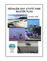
Garibaldi and Barview, Oregon, Tsunami Evacuation Map 02/22 ...
Garibaldi and Barview, Oregon, Tsunami Evacuation Map 02/22 ...
Garibaldi and Barview, Oregon, Tsunami Evacuation Map 02/22 ...

You also want an ePaper? Increase the reach of your titles
YUMPU automatically turns print PDFs into web optimized ePapers that Google loves.
IF YOU FEEL AN EARTHQUAKE:<br />
Drop, cover, <strong>and</strong> hold<br />
Move immediately inl<strong>and</strong> to higher ground<br />
Do not wait for an official warning<br />
SI USTED SIENTE EL TEMBLOR:<br />
<br />
<br />
más alto que el nivel del mar<br />
<br />
LOCAL TSUNAMI<br />
EVACUATION ZONE<br />
PACIFIC<br />
OCEAN<br />
OUTSIDE<br />
HAZARD AREA<br />
BAY BAY LN LN<br />
BARVIEW BARVIEW JETTY JETTY RD RD<br />
DISTANT TSUNAMI<br />
EVACUATION ZONE<br />
10TH 10TH ST ST<br />
7TH 7TH ST ST<br />
S S 7TH 7TH ST ST<br />
PACIFIC PACIFIC AVE AVE<br />
LOCAL TSUNAMI<br />
EVACUATION ZONE<br />
<strong>Garibaldi</strong> <strong>Garibaldi</strong> Elementary Elementary School School<br />
U.S. Coast Guard<br />
Station<br />
TSUNAMI EVACUATION MAP<br />
GARIBALDI & BARVIEW, OREGON<br />
GINGER GINGER AVE AVE<br />
A<br />
EVERGREEN EVERGREEN AVE AVE<br />
ACACIA ACACIA AVE AVE<br />
ASSEMBLY<br />
AREA<br />
BARVIEW<br />
PORT PORT OF OF TILLAMOOK TILLAMOOK BAY BAY RAILROAD<br />
RAILROAD<br />
CEDAR CEDAR ST ST<br />
GARIBALDI<br />
A<br />
3RD 3RD ST ST<br />
Tillamook Bay<br />
A<br />
101<br />
DRIFTWOOD DRIFTWOOD AVE AVE<br />
CYPRESS CYPRESS AVE AVE<br />
GARIBALDI GARIBALDI AVE AVE<br />
LAKESIDE LAKESIDE DR DR<br />
Tillamook Bay<br />
A<br />
ÁREA<br />
<br />
OUTSIDE HAZARD AREA: Evacuate to this<br />
area for all tsunami warnings or if you feel an<br />
earthquake.<br />
LOCAL CASCADIA EARTHQUAKE AND<br />
TSUNAMI: <strong>Evacuation</strong> zone for a local tsunami<br />
from an earthquake at the <strong>Oregon</strong> coast.<br />
DISTANT TSUNAMI: <strong>Evacuation</strong> zone for a<br />
distant tsunami from an earthquake far away<br />
from the <strong>Oregon</strong> coast.<br />
1ST 1ST ST ST<br />
LOCAL TSUNAMI<br />
EVACUATION ZONE<br />
OUTSIDE<br />
HAZARD AREA<br />
101<br />
Terwilliger<br />
Terwilliger<br />
Heights Heights<br />
DR DR<br />
HARBORVIEW<br />
HARBORVIEW<br />
A<br />
FRANKLIN FRANKLIN ST ST<br />
A<br />
Miami<br />
Cove<br />
ZONA DE PELIGRO EXTERIOR: Evacue a esta<br />
área para todas las advertencias del maremoto<br />
o si usted siente un temblor.<br />
MAREMOTO LOCAL (terremoto de Cascadia):<br />
Zona de evacuación para un tsunami local de un<br />
temblor cerca de la costa de <strong>Oregon</strong>.<br />
MAREMOTO DISTANTE: Zona de evacuación<br />
para un tsunami distante de un temblor <br />
de la costa de <strong>Oregon</strong>.<br />
A A<br />
MARTIN MARTIN SMITH SMITH LN LN<br />
A<br />
N<br />
MAP SYMBOLS /<br />
SÍMBOLOS DEL MAPA<br />
<strong>Evacuation</strong> route / Ruta de<br />
evacuación<br />
Assembly area / Área reunión<br />
City Hall / Municipalidad<br />
Law enforcement / Policía<br />
Fire Department / Bomberos<br />
<strong>Tsunami</strong> warning siren / Sirena<br />
de aviso de tsunami<br />
Bridge / Puente<br />
E E GARIBALDI GARIBALDI AVE AVE<br />
PORT PORT OF OF TILLAMOOK TILLAMOOK BAY BAY RAILROAD<br />
RAILROAD<br />
101<br />
SCALE / ESCALA<br />
NOTICE<br />
This tsunami evacuation zone map was developed by DOGAMI for the<br />
purpose of evaluating the most effective means to guide the public<br />
in the event of a tsunami evacuation. The map is based on preliminary<br />
data <strong>and</strong> should not be used for site-specific planning. This map<br />
adopts recommendations from the <strong>Oregon</strong> <strong>Tsunami</strong> Advisory Council.<br />
The evacuation routes were developed by local emergency officials<br />
<strong>and</strong> reviewed by the <strong>Oregon</strong> Department of Emergency Management.<br />
O R E G ON D E P A R T M E N T O F G E O L O G Y A N D M I N E R A L I N D U S T R I E S<br />
1937<br />
MAP REVISED <strong>02</strong>-<strong>22</strong>-12<br />
DISTANT TSUNAMI<br />
EVACUATION ZONE<br />
Miami River<br />
MAP LOCATION<br />
O RE GO<br />
OUTSIDE<br />
HAZARD AREA<br />
0.25 mile<br />
0.25 km<br />
<strong>Oregon</strong><br />
EM<br />
Emergency Management
<strong>Evacuation</strong> for a distant tsunami will generally be indicated by a 3-minute siren blast (if your area has sirens) <strong>and</strong><br />
an announcement over NOAA weather radio that the local area has been put into an official TSUNAMI WARNING.<br />
In isolated areas along beaches <strong>and</strong> bays you may not hear a warning siren. Here, a sudden change of sea level should<br />
prompt you to move immediately to high ground. If you hear the 3-minute blast or see a sudden sea level change, first<br />
evacuate away from shoreline areas, then turn on your local broadcast media or NOAA weather radio for more information.<br />
<br />
<br />
<br />
<br />
<br />
<br />
<br />
<br />
A distant tsunami will take 4 hours or more to come ashore. You will feel no earthquake, <strong>and</strong> the tsunami will generally<br />
be smaller than that from a local earthquake. Typically, there is time for an official warning <strong>and</strong> evacuation to safety.<br />
*Assembly areas A are shown on the map. Do not confuse Assembly Areas with<br />
<strong>Evacuation</strong> Centers, which are short-term help centers set up after a disaster occurs.<br />
4. After evacuation, check with local emergency officials if<br />
you think you have special skills <strong>and</strong> can help, or if you<br />
need assistance locating lost family members.<br />
3. Stay away from potentially hazardous areas until you receive<br />
an ALL CLEAR from local officals. <strong>Tsunami</strong>s often follow river<br />
channels, <strong>and</strong> dangerous waves can persist for several hours.<br />
Local officials must inspect all flooded or earthquake-damaged<br />
structures before anyone can go back into them.<br />
2. If you need help evacuating, tie something<br />
white (sheet or towel) to the front door knob. Make it large<br />
enough to be visible from the street. If the emergency is a<br />
distant tsunami, then help may arrive. In the event of a local<br />
tsunami, it is unlikely that anyone will help you, so make a plan<br />
<strong>and</strong> be prepared!<br />
If you feel an earthquake,<br />
a tsunami may be<br />
coming...<br />
WHAT TO DO:<br />
DROP, COVER, HOLD until the<br />
earthquake is over; protect yourself<br />
MOVE IMMEDIATELY INLAND to<br />
high ground <strong>and</strong> away from low-lying<br />
coastal areas<br />
1. Evacuate on foot, if at all possible.<br />
Follow evacuation signs <strong>and</strong> arrows<br />
to an Assembly Area.*<br />
WHAT TO DO for both local<br />
<strong>and</strong> distant tsunamis<br />
FOLLOW EVACUATION ROUTE SIGNS<br />
DO NOT WAIT for an offical warning<br />
GO ON FOOT if at all possible<br />
DO NOT PACK or delay<br />
DO NOT RETURN to the beach –<br />
large waves may continue to come<br />
onshore for several hours<br />
WAIT for an “all clear” from local<br />
emergency officials before returning to<br />
low-lying areas<br />
CONTACTS<br />
<strong>Oregon</strong> Emergency Management<br />
3<strong>22</strong>5 State Street, Salem, OR 97301<br />
P.O. Box 14370, Salem, OR 97309-5062<br />
(503) 378-2911<br />
http://www.oregon.gov/OMD/OEM/<br />
Tillamook County Sheriff’s Office<br />
5995 Long Prairie Road<br />
Tillamook, OR 97141<br />
(503) 815-2561<br />
http://www.tillamooksheriff.org<br />
<strong>Garibaldi</strong> Fire Department<br />
107 6th Street<br />
<strong>Garibaldi</strong>, OR<br />
(503) 3<strong>22</strong>-3635<br />
http://www.ci.garibaldi.or.us/ps.html<br />
<strong>Oregon</strong> Department of Geology <strong>and</strong> Mineral Industries<br />
800 NE <strong>Oregon</strong> Street #28, Suite 965<br />
Portl<strong>and</strong>, OR 97232<br />
(971) 673-1555<br />
http://www.oregongeology.org<br />
Nature of the Northwest Information Center<br />
800 NE <strong>Oregon</strong> Street #28, Suite 177<br />
Portl<strong>and</strong>, OR 97232<br />
(971) 673-2331<br />
http://www.naturenw.org<br />
International <strong>Tsunami</strong> Information Center<br />
737 Bishop Street, Suite <strong>22</strong>00<br />
Honolulu, HI 96813<br />
(808) 532-64<strong>22</strong><br />
http://itic.ioc-unesco.org<br />
NATIONAL OCEANIC AND ATMOSPHERIC ADMINISTRATION<br />
U.S. DEPARTMENT<br />
A local tsunami can come onshore<br />
within 15 to 20 minutes after the<br />
earthquake — before there is time<br />
for an official warning from the<br />
national warning system. Ground<br />
shaking from the earthquake may<br />
be the only warning you have.<br />
Evacuate quickly!<br />
A<br />
We distinguish between a tsunami caused by an undersea earthquake near the <strong>Oregon</strong> coast (a<br />
local tsunami) <strong>and</strong> an undersea earthquake far away from the coast (a distant tsunami).<br />
Recent research suggests that tsunamis have struck the <strong>Oregon</strong> coast on a regular basis. They can<br />
occur any time, day or night. Typical wave heights from tsunamis occurring in the Pacific Ocean<br />
over the last 500 years have been 20–65 feet at the shoreline. However, because of local conditions<br />
a few waves may have been much higher — as much as 100 feet.<br />
A tsunami is a series of sea waves, usually caused by a displacement of the ocean floor by an<br />
undersea earthquake. As tsunamis enter shallow water near l<strong>and</strong>, they increase in height <strong>and</strong> can<br />
cause great loss of life <strong>and</strong> property damage.<br />
BE PREPARED! WHAT TO KNOW about tsunamis<br />
OF COMMERCE<br />
Local tsunamis<br />
Climb to<br />
Assembly<br />
Area<br />
O R E G ON D E PA R T M E N T O F G EO L O G Y A N D M I N E R A L I N U S T R I E S<br />
1937<br />
Distant tsunamis<br />
<strong>Oregon</strong><br />
EM<br />
Emergency Management<br />
Funded by the National Oceanic <strong>and</strong> Atmospheric Adminstration under NTHMP<br />
contract award DG133W07CN0335 through the <strong>Oregon</strong> Department of Geology <strong>and</strong><br />
Mineral Industries. Published by the <strong>Oregon</strong> Department of Geology <strong>and</strong> Mineral<br />
Industries in consultation with Tillamook County Emergency Services officials.<br />
IN CASE OF EARTHQUAKE, GO<br />
TO HIGH GROUND OR INLAND<br />
TSUNAMI HAZARD ZONE<br />
Look for these hazard zone signs<br />
<strong>and</strong> be ready to leave the area by<br />
following evacuation route signs.<br />
How to help with tsunami awareness<br />
in your community<br />
tem<br />
<br />
<br />
Assemble emergency kits with at least a 3-day supply<br />
for each family member:<br />
Local map showing safe evacuation routes to high ground.<br />
First-aid supplies, prescriptions <strong>and</strong> non-prescription<br />
medication.<br />
Water bottle <strong>and</strong> filtration or treatment supplies<br />
capable of providing 1 gallon per person per day.<br />
Non-perishable food (ready-to-eat meals,<br />
canned food, baby food, energy bars).<br />
Cooking <strong>and</strong> eating utensils, can opener, Sterno®<br />
or other heat source.<br />
Matches in water-proof container or lighter.<br />
Shelter (tent), sleeping bags, blankets.<br />
Portable radio, NOAA weather radio, flashlight,<br />
<strong>and</strong> extra batteries.<br />
Rain gear, sturdy footwear, extra clothing.<br />
Personal hygiene items (toilet paper, soap, toothbrush)<br />
Tools <strong>and</strong> supplies (pocket knife, shut-off wrench,<br />
duct tape, gloves, whistles, plastic bags<br />
Cash<br />
<strong>Garibaldi</strong> & <strong>Barview</strong><br />
OREGON<br />
This information could<br />
save your life –<br />
Please read it <strong>and</strong> share it<br />
with your family <strong>and</strong> friends.<br />
EVACUATION<br />
MAP ON REVERSE