Banks-Vernonia State Trail map - Oregon State Parks
Banks-Vernonia State Trail map - Oregon State Parks
Banks-Vernonia State Trail map - Oregon State Parks

Create successful ePaper yourself
Turn your PDF publications into a flip-book with our unique Google optimized e-Paper software.
iver<br />
6<br />
26<br />
McGuire<br />
Reservoir<br />
Nehalem River<br />
47<br />
W<br />
ST. HELENS<br />
VERNONIA<br />
A S H I<br />
30<br />
N<br />
5<br />
G<br />
BANKS-VERNONIA<br />
T<br />
STATE TRAIL<br />
O N<br />
Stub Stewart<br />
<strong>State</strong> Park<br />
205<br />
BANKS<br />
FOREST GROVE<br />
McMINNVILLE<br />
47<br />
NEWBERG<br />
99<br />
W<br />
HILLSBORO<br />
Wil lamette<br />
26<br />
River<br />
219<br />
8<br />
BEAVERTON<br />
5<br />
99<br />
E<br />
Columbia River<br />
LAKE<br />
OSWEGO<br />
CANBY<br />
www.oregonstateparks.org<br />
VANCOUVER<br />
PORTLAND<br />
This publication is available in alternative formats on request.<br />
Call 1-800-551-6949 (for the hearing impaired 1-800-735-2900).<br />
63400-8512 (12/10)<br />
For More Information:<br />
<strong>Banks</strong>-<strong>Vernonia</strong> <strong>State</strong> <strong>Trail</strong><br />
L.L. “Stub” Stewart Management Unit<br />
30380 NW Highway 47<br />
Buxton, OR 97109<br />
Phone: (503) 324-0606<br />
Printed on<br />
Recycled Paper<br />
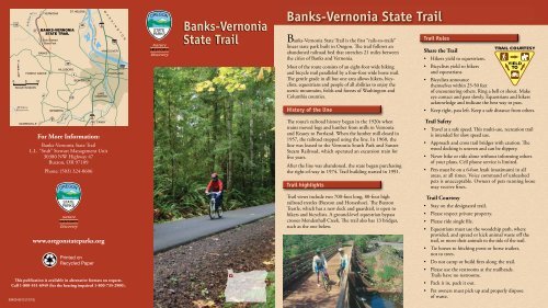
<strong>Banks</strong>-<strong>Vernonia</strong><br />
<strong>State</strong> <strong>Trail</strong><br />
<strong>Banks</strong>-<strong>Vernonia</strong> <strong>State</strong> <strong>Trail</strong><br />
<strong>Banks</strong>-<strong>Vernonia</strong> <strong>State</strong> <strong>Trail</strong> is the first “rails-to-trails”<br />
linear state park built in <strong>Oregon</strong>. The trail follows an<br />
abandoned railroad bed that stretches 21 miles between<br />
the cities of <strong>Banks</strong> and <strong>Vernonia</strong>.<br />
Most of the route consists of an eight-foot wide hiking<br />
and bicycle trail paralleled by a four-foot wide horse trail.<br />
The gentle grade in all but one area allows hikers, bicyclists,<br />
equestrians and people of all abilities to enjoy the<br />
scenic mountains, fields and forests of Washington and<br />
Columbia counties.<br />
History of the line<br />
The route’s railroad history began in the 1920s when<br />
trains moved logs and lumber from mills in <strong>Vernonia</strong><br />
and Keasey to Portland. When the lumber mill closed in<br />
1957, the railroad stopped using the line. In 1960, the<br />
line was leased to the <strong>Vernonia</strong> South Park and Sunset<br />
Steam Railroad, which operated an excursion train for<br />
five years.<br />
After the line was abandoned, the state began purchasing<br />
the right-of-way in 1974. <strong>Trail</strong> building started in 1991.<br />
<strong>Trail</strong> highlights<br />
<strong>Trail</strong> views include two 700-foot long, 80-foot high<br />
railroad trestles (Buxton and Horseshoe). The Buxton<br />
Trestle, which has a new deck and guardrail, is open to<br />
hikers and bicyclists. A ground-level equestrian bypass<br />
crosses Mendenhall Creek. The trail also has 13 bridges,<br />
such as the one below.<br />
<strong>Trail</strong> Rules<br />
Share the <strong>Trail</strong><br />
• Hikers yield to equestrians.<br />
• Bicyclists yield to hikers<br />
and equestrians.<br />
• Bicyclists announce<br />
themselves within 25-50 feet<br />
of encountering others. Ring a bell or shout. Make<br />
eye contact and pass slowly. Equestrians and hikers<br />
acknowledge and indicate the best way to pass.<br />
• Keep right, pass left. Keep a safe distance from others.<br />
<strong>Trail</strong> Safety<br />
• Travel at a safe speed. This multi-use, recreation trail<br />
is intended for slow speed use.<br />
• Approach and cross trail bridges with caution. The<br />
wood decking is uneven and can be slippery.<br />
• Never hike or ride alone without informing others<br />
of your plans. Cell phone service is limited.<br />
• Pets must be on a 6-foot leash (maximum) in all<br />
areas, at all times. Voice command of unleashed<br />
pets is unacceptable. Owners of pets running loose<br />
may receive fines.<br />
<strong>Trail</strong> Courtesy<br />
• Stay on the designated trail.<br />
• Please respect private property.<br />
• Please ride single file.<br />
• Equestrians must use the woodchip path, where<br />
provided, and spread or kick animal waste off the<br />
trail, or move their animals to the side of the trail.<br />
• Tie horses to hitching posts or horse trailers,<br />
not to trees.<br />
• Do not camp or build fires along the trail.<br />
• Please use the restrooms at the trailheads.<br />
<strong>Trail</strong>s have no restrooms.<br />
• Pack it in, pack it out.<br />
• Pet owners must pick up and properly dispose<br />
of waste.
Kist Creek<br />
Robins on Creek<br />
Johnson Rd<br />
Cummings Creek<br />
Strass el C reek<br />
Burgholzer Creek<br />
Legend<br />
Nehalem Hwy<br />
26<br />
MILE 18<br />
MILE 14<br />
Poliwa ski Canyon<br />
Paved <strong>Trail</strong><br />
Unpaved <strong>Trail</strong><br />
<strong>Trail</strong>head<br />
Parking<br />
Restroom<br />
(ADA accessible)<br />
VERNONIA<br />
Bear Creek<br />
MILE 17<br />
MILE 19<br />
MILE 16<br />
MILE 12<br />
Paisley Canyon<br />
Vault Restroom<br />
(ADA accessible)<br />
N ehalem River<br />
Beaver Creek<br />
Interpretive Exhibit<br />
Picnic Shelter<br />
Park Boundary<br />
Stub Stewart <strong>State</strong> Park<br />
Highways<br />
Roads<br />
Water<br />
TOPHILL<br />
TREHARNE<br />
MILE 11<br />
MILE 15<br />
Nowakowski Rd<br />
MILE 10<br />
Nehalem Hwy<br />
0 0.5 1 2<br />
Miles<br />
1 inch = 1.2 miles<br />
6<br />
Swamp Cr eek<br />
MILE 13<br />
MILE 8<br />
W illiams Creek<br />
MILE 7<br />
MILE 21<br />
MILE 20<br />
Kuder Creek<br />
Pebble Creek<br />
B eaver Creek<br />
West Fork Dairy Creek<br />
Sunset Hwy<br />
Pebble Creek Rd<br />
Beaver Creek<br />
<strong>Trail</strong>head<br />
Parking<br />
Restroom<br />
Picnicking<br />
McDonald Rd<br />
47<br />
Fisher Rd<br />
Bacona Rd<br />
US 26<br />
Hilltop<br />
Day-use<br />
Area<br />
MILE 9<br />
47<br />
Dell Creek<br />
Welcome Center<br />
Pihl Road<br />
Hike-in Camp<br />
Sell Road<br />
Logging Creek<br />
MILE 6<br />
47<br />
Wilson River Hwy<br />
Nehalem Highway<br />
Tophill <strong>Trail</strong>head<br />
ADA Accessible Equestrian<br />
Loading Platform<br />
Horseshoe Trestle<br />
Parking<br />
Restroom<br />
Hitching Posts<br />
Coal Creek<br />
Buxton Creek<br />
BUXTON<br />
Manning<br />
<strong>Trail</strong>head<br />
Parking<br />
No Restroom<br />
B-V <strong>Trail</strong><br />
<strong>Vernonia</strong><br />
<strong>Trail</strong>head<br />
26<br />
Beaver<br />
MILE 5<br />
Park Farms Creek<br />
Cre ek<br />
OR 47<br />
Mead Rd<br />
B-V <strong>Trail</strong><br />
Beaver Creek<br />
Menden hall Creek<br />
MILE 4<br />
C O L U M B I A<br />
W A S H I N G T O N<br />
B-V <strong>Trail</strong><br />
L.L. “Stub”<br />
Stewart<br />
<strong>State</strong> Park<br />
Whitcher Cre ek<br />
Pihl Rd<br />
Rose Ave.<br />
B-V <strong>Trail</strong><br />
Rock Creek<br />
MILE 3<br />
MILE 2<br />
Umatilla St.<br />
Buxton<br />
<strong>Trail</strong>head<br />
ADA Accessible<br />
Equestrian<br />
Loading Platform<br />
Buxton Trestle<br />
Interpretive <strong>Trail</strong><br />
Parking<br />
Restroom<br />
Picnicking<br />
Whistle Stop Shelter<br />
Sell Rd<br />
MILE 1<br />
Cedar Canyon Creek<br />
Pebble Creek<br />
MANNING<br />
Cedar Canyon Rd<br />
Weed Ave.<br />
Up to 11% grade<br />
Denny Creek<br />
Garrigus Creek<br />
B-V <strong>Trail</strong><br />
Nehalem River<br />
Wes t For k Dair y Cr eek<br />
Nehalem Hwy<br />
BANKS<br />
Elk Creek<br />
Nehalem Highway<br />
Up to 11% grade<br />
Sellers Rd<br />
Bacona Road<br />
Trestle open<br />
to hikers<br />
and bicyclists.<br />
47<br />
<strong>Banks</strong>-<br />
<strong>Vernonia</strong><br />
<strong>State</strong> <strong>Trail</strong><br />
Horseshoe<br />
Kenusky Creek<br />
Creek<br />
Jim George<br />
Campbell Creek<br />
Roundy Creek<br />
Whiskey Creek<br />
M urtaugh Creek<br />
Bausch Creek<br />
<strong>Banks</strong> Rd<br />
Aerts Rd<br />
Trestle<br />
<strong>Trail</strong>head access and equestrian bypass<br />
B x o res e<br />
u t n T tl<br />
B-V <strong>Trail</strong><br />
East Fork Nehalem River<br />
Please stay on the designated trail.<br />
DO NOT TRESPASS ON<br />
PRIVATE PROPERTY.<br />
<strong>Banks</strong><br />
<strong>Trail</strong>head<br />
Parking<br />
Restroom<br />
Interpretive<br />
Exhibit<br />
No RV or <strong>Trail</strong>er<br />
Parking<br />
26<br />
B-V <strong>Trail</strong><br />
6<br />
Mendenhall<br />
Cre ek<br />
0 300<br />
Parking<br />
SCALE IN<br />
FEET<br />
NW Sellers Rd<br />
NW <strong>Banks</strong> Rd<br />
East Fork Dairy C reek<br />
Park Boundary<br />
Wirtz Branch