Complete List of Maps Available
Complete List of Maps Available
Complete List of Maps Available

You also want an ePaper? Increase the reach of your titles
YUMPU automatically turns print PDFs into web optimized ePapers that Google loves.
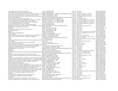
La crise religieuse au XVIme siecle / par Louis André Paris : Impr. Michard, [1965?] 1 map : col. 92 x 123 cm G5701.S4 1965 .D45 Wall<br />
Europe about 1560 / series editor and map editor, R. R. Palmer Chicago : Rand McNally, 1965 1 map : col. 79 x 122 cm G5701.S4 1965 .R3 Wall<br />
Europe in 1740 : (from Treaty <strong>of</strong> Utrecht 1713 to January 1740) : with partitions <strong>of</strong> Poland Chicago / by Samuel : Denoyer-‐Geppert B. Harding. Co. : [Distributed by Rand McNally & Co., 1967?] 1 map : col., mounted on spring roller 74 x 109 cm. G5701.S5 1963 .D4 Wall<br />
Europe in 1815 : after the Treaty <strong>of</strong> Vienna / series and map editor R.R. Palmer. [Chicago : Rand McNally and Co., 1963?] 1 map : col., mounted on spring roller 79 x 122 cm. G5701.S5 1963.R3 Wall<br />
Europe in 1810 : at the height <strong>of</strong> Napoleon's power / series and map editor R.R. Palmer. [Chicago : Rand McNally and Co., 198-‐?] 1 map : col., mounted on spring roller 79 x 122 cm. G5701.S5 1965.R3 Wall<br />
Europa im Zeitalter Napoleons I Leipzig : Hermann Haack Geographisch-‐Kartographische Anstalt Gotha, 1966 1 map : col. 154 x 188 cm G5701.S5 1966 .H25 Wall<br />
Europa von 1815 bis 1871 / Bearbeitet von W. Trillmich Braunschweig : Georg Westermann Verlag, c1969 3 maps : col. on sheet 138 x 205 cm G5701.S5 1969 .W4 Wall<br />
Europa : neuordnung durch den Wiener Kongress (1815-‐1829) / W. u. W. Hilgemann Darmstadt : Justus Perthes : W. u. W. Hilgemann, [1975] 1 wall map : col., mounted on wooden rods 133 x 147 cm G5701.S5 1975 .J98 Wall<br />
Europa : B√ºndnissysteme Bismarcks (1871-‐1890) / W. u. W. Hilgemann Darmstadt : Justus Perthes : W. u. W. Hilgemann, [198-‐] 1 wall map : col., mounted on wooden rods 132 x 146 cm G5701.S5 1980 .J98 Wall<br />
Europa : die Julirevolution und ihre Folgen (1830-‐1847) / W. u. W. Hilgemann Darmstadt : Justus Perthes : W. u. W. Hilgemann, [198-‐] 1 wall map : col., mounted on wooden rods 134 x 146 cm G5701.S5 1980 .J99 Wall<br />
Europa : B√ºndnisse (1892-‐1914) / W. u. W. Hilgemann Gotha : Justus Perthes, c1993 1 wall map : col., mounted on wooden rods 139 x 147 cm G5701.S6 1993 .K54 Wall<br />
Europe in 1914 / series editor, R. R. Palmer map editor, Charles Jelavich Chicago : Rand McNally, c1964 1 map : col. 79 x 112 cm G5701.S65 1964 .R3 Wall<br />
Europe after World War II [map] : showing changes to 1950 / series editor, R. R. Palmer Chicago map editor, : Rand Charles McNally Jelavich. and Co., Educational Publishing Dept., 19-‐-‐. 1 map : col. 88 x 118 cm. fold in cover 26 x 30 cm. G5701.S73 1965.R3 Wall<br />
Zapadnaia Evropa : dlia vysshikh uchebnikh zavednii Moskva : GUGK, 1955 1 map : col. 244 x 193 cm G5720 1955 .R8 Wall<br />
Westeuropa [Munchen] : Paul <strong>List</strong> Verlag, [1960?] 1 map : col. 222 x 160 cm G5721.C1 1960 .W45 Wall<br />
Philip's schoolroom map <strong>of</strong> Great Britain and Ireland : political London : George Philip & Son, c1966 1 map : col. 174 x 117 cm G5740 1966 .P4 Wall<br />
Great Britain and Ireland London : George Philip & Son, c1964 1 map : col. 175 x 116 cm G5741.C1 1964 .P4 Wall<br />
British Isles Chicago : Rand McNally, [199-‐] 5 maps on 1 sheet : col., plastic sheet 82 x 112 cm., folded to G5741.S1 21 x 28 cm. 1990 and.R3 attached Wall in folder 27 x 30 cm<br />
Ordnance Survey map <strong>of</strong> Roman Britain. Chessington : The Survey, 1956. 1 map : col. 99 x 76 cm.+ 1 booklet (43 p. : maps 27 cm. G5741.S2 1956.G7 Wall<br />
England and Wales. London : London Geographical Institute, c1962. col. map 170 x 150 cm. G5751.C1 1962.P4 Wall<br />
Saxon and Norman England / by Samuel B. Harding L. Philip Denoyer, geographer compiled Chicago and[Ill.] drawn : Denoyer-‐Geppert by R. Baxter Blair. Co., 1963. 2 maps on 1 sheet : col. sheet 91 x 111 cm. G5751.S33 1963.D4 Wall<br />
Industrial England / by Samuel B. Harding L. Philip Denoyer, geographer. Chicago [Ill.] : Denoyer-‐Geppert Co., 1964. 2 maps on 1 sheet : col., linen-‐backed sheet 91 x 111 cm. G5751.S6 1964.D45 Wall<br />
London Braunschweig: G. Westermann Chicago: Denoyer-‐Geppert, 1973 2 maps : col. on sheet 134 x 109 cm G5754.L7 1973 .W4 Wall<br />
London [S.l.] : Westermann, c1977 2 maps on 1 sheet : col. 64 x 84 cm and 38 x 84 cm, sheet 119G5754.L7 x 107 cm1977<br />
.G3 Wall<br />
France politique : departements, villes, chemins de fer, canaux, population / Girard, Barrere, Paris editeurs : Impr. Michard, 1965 1 map : col. 93 x 122 cm G5830 1965.G5 Wall<br />
France et Benelux. Leipzig, 1978. col. map 204 x 159 cm. on 4 sheets 112 x 86 cm. G5831.C1 1978.H3 Wall<br />
France : agriculture, industrie et commerce / par J. Forest, geographe Paris : Impr. Michard, 1956 1 map : col. 94 x 122 cm G5831.G1 1956 .G57 Wall<br />
Caesar's Gaul / by James H. Breasted. Chicago [Ill.] : Denoyer-‐Geppert Co., c1970. 1 historical map : col. 73 x 103 cm. G5831.S2 1970.D45 Wall<br />
Paris et son expansion. [Par] Librarie Hatier. Conception B. Dezert. Cartographie TissaireParis, & Gabelli. c1977. col. map on sheet 100 x 122 cm. G5834.P3A1 1977 .H3 Wall<br />
Central Europe / compiled and printed by Polish State Cartographical Publishers Warsaw : Polish State Cartographical Publishers, 196-‐? 1 map : col. 98 x 131 cm G6030 1970 .P3 Wall<br />
Mitteleuropa / [von] Haack [und] Painke Schummerung, G Pohlmann Darmstadt, Germany : Justus Perthes, [1964] 1 map : col. 200 x 187 cm G6031.C1 1964 .H3 Wall<br />
Mitteleuropa [map] / Dr. Hermann Haack. Leipzig, East Germany : Hermann Haack Geographisch-‐Kartographische Anstalt 1 map Gotha: col. Chicago, 198 XIll. 205 : Denoyer-‐Geppart, cm. 1968.<br />
G6031.C1 1968.H3 Wall<br />
Mitteleuropa [Munchen] : Paul <strong>List</strong> Verlag, [1970?] 1 map : col. 163 x 225 cm G6031.C1 1970 .W45 Wall<br />
Mitteleuropa Gotha : Justus Perthes : Haack-‐Painke, c1998 1 wall map : col., mounted on wooden rods 208 x 198 cm G6031.C1 1998 .J98 Wall<br />
Central Europe 1914 to the present day / cartography and printing by Georg Westermann Braunschweig English text: edition Georg Westermann prepared withVerlag, the editorial c1967 assistance <strong>of</strong> Denoyer-‐Geppert 4 maps Company : col. 94 x 98 cm. on sheet 200 x 203 cm G6031.S6 1967 .W47 Wall<br />
Schweiz. Gotha, VEB Hermann Haack, Geographisch-‐Kartographische Anstalt [1971] col. map 155 x 203 cm. on 4 sheets 86 x 112 cm. G6041.C1 1971.H3 Wall<br />
Deutschland / Zeichnung, Reproduktion und Druck, Karl Wenschow GmbH [Munchen] : Paul <strong>List</strong> Verlag, [1960?] 1 map : col. 156 x 236 cm G6081.C2 1937 .W4 Wall<br />
Unification <strong>of</strong> Germany : Bismarck's empire / series editor and map editor R.R. Palmer. [Chicago : Rand McNally and Co., 1965?] 1 map : col., mounted on spring roller 75 x 117 cm. G6081.S5 1965.R3 Wall<br />
Osterreich Wien : Freytag, Berndt und Artaria, [1963] 1 map : col. 70 x 102 cm G6491.C1 1963 .F7 Wall<br />
The Mediterranean world, 550-‐500 B.C. / [by] Daniel C. Knowlton [and] T. Walter Wallbank Chicago : A. J. Nystrom and Company, [1955] 1 map : col. 87 x 120 cm G6531.S2 1955 .K5 Wall<br />
Alexander's empire / by James H. Breasted and Carl F. Huth, Jr. L. Philip Denoyer, geographer. Chicago [Ill.] : Denoyer-‐Geppert Co., c1969. 1 historical map : col. 70 x 105 cm. G6531.S2 1960.D45 Wall<br />
Ancient world in the 7th century B.C. [map] / Rand McNally map editor, Tom B. Jones. [Chicago] : Rand McNally & Co., [c1963?] 1 map : col. 74 x 107 cm. G6531.S2 1963.R3 Wall<br />
Alexander's empire / series editor, R. R. Palmer map editor, Tom B. Jones Chicago : Rand McNally, c1963 1 map : col. 92 x 122 cm G6531.S2 1963 .R35 Wall<br />
Ancient Italy & growth <strong>of</strong> Roman power Chicago : Rand McNally and Company, [1980?] 2 maps : col. on sheet 97 x 112 cm G6701.S12 1980 .R3 Wall<br />
Ancient Italy / by James H. Breasted and Carl F. Huth, Jr. Chicago, [Ill.] : Denoyer-‐Geppert Co., c1960. 2 maps on 1 sheet : col. 90 x 111 cm. G6701.S2 1960.D45 Wall<br />
Roman Empire at the time <strong>of</strong> Augustus / [edited] by James H. Breasted and Carl F. Huth Chicago : Denoyer-‐Geppert, [1960?] 1 map : col. 73 x 108 cm G6701.S2 1960 .D46 Wall<br />
Conquest <strong>of</strong> Mediterranean / compiled and drawn by R. Baxter Blair L. Philip Denoyer, geographer Chicago : Denoyer-‐Geppert, [edited] by James 1962 H. Breasted and Carl F. Huth<br />
7 maps : col. on sheet 80 x 111 cm G6701.S2 1962 .D4 Wall<br />
Italia antigua imperatorum Romanorum aetate / Plinius Fraccaro delineavit Novara : Istituto Geografico de Agostini, c1962 1 map : col. 168 x 130 cm G6701.S2 1962 .I8 Wall<br />
Roman Empire about 120 A.D. and Roman Republic / series editor, R. R. Palmer map editor, Chicago Tom: Rand B. Jones McNally, c1963 1 map : col. 91 x 121 cm G6701.S2 1963 .R27 Wall<br />
Roman Empire about 400 A.D. and the Barbarian invasions / series editor, R. R. Palmer map Chicago editor, : Rand Sidney McNally, Painter c1963 1 map : col. 92 x 122 cm G6701.S2 1963 .R3 Wall<br />
Roman power and reference Italy / compiled and drawn by R. Baxter Blair Chicago : Denoyer-‐Geppert Co., 1964 5 maps on 1 sheet : col., mounted on linen sheet 90 x 111 cmG6702.S2 1964 .D4 Wall<br />
L'Italia nel 1559 : la preponderanza spagnuola / [di] Plinio Fraccaro Novara : Istituto Geografico de Agostini, c1965 1 map : col. 169 x 130 cm G6706.S5 1965 .I8 Wall<br />
Italia politica Torino : Paravia, 1965 1 map : col. 200 x 165 cm G6710 1965 .P3 Wall<br />
Apenninen-‐Halbinsel / Kartographie und Druck, Georg Westermann Braunschweig : Georg Westermann Verlag, c1970 1 map : col. 171 x 146 cm G6711.C1 1970 .W47 Wall<br />
Unification <strong>of</strong> Italy / series editor and map editor R.R. Palmer. [Chicago : Rand McNally and Co., 198-‐?] 1 map : col., mounted on spring roller 74 x 117 cm. G6711.S5 1965.R3 Wall<br />
Ancient Rome. Greenwich, Conn. [1971?] col. map 87 x 122 cm. G6714.R7S1 1971 .T3 Wall<br />
S√ºdosteuropa. Kartographie: H. Perlt. Gel√§nde: E. Frank/H. Peuckert. Gotha, VEB Hermann Haack, Geographisch-‐Kartographische Anstalt [1972] col. map 185 x 183 cm. on 3 sheets 95 x 125 cm. G6801.C1 1972.H3 Wall<br />
Donauraum und Balkan-‐Halbinsel / Kartographie und Druck, Georg Westermann Braunschweig : Georg Westermann Verlag, c1972 1 map : col. 204 x 170 cm G6801.C1 1972 .W47 Wall
![For the complete text [PDF] of George Barati - University Library ...](https://img.yumpu.com/17813149/1/190x245/for-the-complete-text-pdf-of-george-barati-university-library-.jpg?quality=85)