Complete List of Maps Available
Complete List of Maps Available
Complete List of Maps Available

Create successful ePaper yourself
Turn your PDF publications into a flip-book with our unique Google optimized e-Paper software.
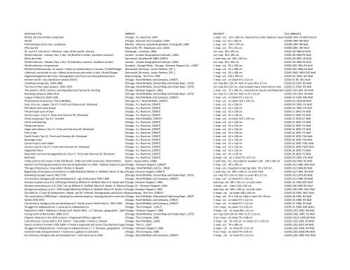
Wall Map TITLE IMPRINT DESCRIPT. CALL #(BIBLIO)<br />
World, Van Der Grinten projection Chicago : A.J. Nystrom, 1943 1 map : col. 112 x 160 cm. mounted on cloth, folded in cover G3200 1943 .F5 Wall Case B<br />
World Chicago : Nystrom and Company, 1964 1 map : col. 61 x 118 cm G3200 1964 .N8 Wall<br />
Politicheskaia karta mira uchebnaia Moskva : Glavnoe upravlenie geodezii i kartografii, 1964 1 map : col. 114 x 174 cm G3200 1964 .R8 Wall<br />
[The world] Mountville, PA : MapQuest.com, c2001 1 map : col. 70 x 131 cm G3200 2001 .M3 Wall<br />
W. and A.K. Johnston's effective maps <strong>of</strong> the world : climate. Edinburgh : Johnston, 1964. col. map 80 x 105 cm. G3201.C8 1964.J6 Wall<br />
World relations : climate, Nov. 1-‐Apr. 30 (Northern winter, Southern summer). London : London Geographical Institute, c1964. col. map 80 x 105 cm. G3201.C8 1964.P4 Wall<br />
Klima der Erde Darmstadt, Gesellschaft MBH [1965?] 1 wall map. col. 140 x 202 cm G3201.C8 1965 .J8 Wall<br />
World relations : climate, May 1-‐Oct. 31 (Northern summer, Southern winter). London : London Geographical Institute, c1965. col. map 80 x 105 cm. G3201.C8 1965.P4 Wall<br />
World relations, temperature. [London] : George Philip Chicago : Denoyer-‐Geppert Co., c1967. 1 map : col. 81 x 104 cm. G3201.C82 1961.P4 Wall<br />
Mittlere lufttemperatur im Januar = Mean air temperature in January / Rudolf Geiger. Darmstadt, Germany : Justus Perthes, [19-‐-‐] 1 map : col. 62 x 108 cm. G3201.C82 1966.G4 Wall<br />
Luftdruck und winde im July = Mean air pressure and winds in July / Rudolf Geiger. Darmstadt, Germany : Justus Perthes, [19-‐-‐] 1 map : col. 62 x 108 cm. G3201.C842 1963.G42 Wall<br />
Vegetationsgebeite der Erde / Kartographie und Druck von Georg Westermann Braunschweig : The Firm, 1966 1 map : col. 118 x 195 cm G3201.D2 1966 .W4 Wall<br />
Ancient world : race distribution about 250 B.C Chicago : Rand McNally and Company, [1980?] 1 map : col. on sheet 97 x 112 cm G3201.E1 BC .R31 Wall<br />
Unwilling immigrants, 1600-‐1808. [Chicago Rand McNally, School Map and Globe Dept., 1976] col. map 89 x 123 cm. fold. in cover 30 x 27 cm. G3201.E9 1976 .R3 Wall<br />
The time <strong>of</strong> the super powers, 1945-‐1956. [Chicago Rand McNally, School Map and Globe Dept., 1975] col. map 96 x 122 cm. vinyl-‐coated sheet, mounted on rods. G3201.F1 1956 .R3 Wall<br />
The world in 1914: colonies and dependencies/ Samuel B. Harding Chicago: Denoyer-‐Geppert, 1963. 1 map : col. 75 x 108 cm., mounted on muslin and fitted withG3201.F33 rods. 1963 .D4 Wall<br />
Reaching outward, 1860-‐1914. [Chicago Rand McNally, School Map and Globe Dept., 1975] col. map 71 x 120 cm. fold. to 27 x 22 cm. G3201.F35 1914 .R3 Wall<br />
League <strong>of</strong> Nations 1920-‐1930 Chicago : Rand McNally and Company, [1980?] 1 map : col. on sheet 97 x 112 cm G3201.F5 1930 .R36 Wall<br />
Predominant economies / Rand McNally. [Chicago, Ill.] : Rand McNally, [1954?] 1 map : col. on sheet 107 x 145 cm. G3201.G1 1954.E8 Wall<br />
Coal, iron ore, copper / by V.C. Finch and Clarence W. Olmstead Chicago : A.J. Nystrom, [1950?] 1 map : col. 61 x 118 cm G3201.H1 1950 .F5 Wall<br />
Petroleum and waterpower Chicago : A.J. Nystrom, [1950?] 1 map : col. 61 x 118 cm G3201.H1 1950 .F5 Wall<br />
The principal uses <strong>of</strong> land Chicago : A.J. Nystrom, [1950?] 1 map : col. 61 x 118 cm G3201.J1 1950 .F5 Wall<br />
Cereal crops I / by V.C. Finch and Clarence W. Olmstead Chicago : A.J. Nystrom, [1950?] 1 map : col. 61 x 118 cm G3201.J1 1950 .F5 Wall<br />
Great soil groups / by A.C. Orvedel. Chicago : Rand McNally, [1954?] 1 map : col. on sheet 107 x 145 cm. G3201.J3 1954.O7 Wall<br />
Cattle and dairying Chicago : A.J. Nystrom, [1950?] 1 map : col. 61 x 118 cm G3201.J5 1950 .F5 Wall<br />
Sheep and swine. Chicago : A.J. Nystrom, [1950?] 1 map : col. 61 x 118 cm G3201.J5 1950 .F5 Wall<br />
Sugar and tobacco / by V.C. Finch and Clarence W. Olmstead Chicago : A.J. Nystrom, [1950?] 1 map : col. 61 x 118 cm G3201.J6 1950 .F5 Wall<br />
Fruit crops Chicago : A.J. Nystrom, [1950?] 1 map : col. 61 x 118 cm G3201.J6 1950 .F5 Wall<br />
Starch foods / by V.C. Finch and Clarence W. Olmstead Chicago : A.J. Nystrom, [1950?] 1 map : col. 61 x 118 cm G3201.J6 1950 .F56 Wall<br />
Beverage crops Chicago : A.J. Nystrom, [1950?] 1 map : col. 61 x 118 cm G3201.J6 1950 .F56 Wall<br />
Cereal crops II and rubber Chicago : A.J. Nystrom, [1950?] 1 map : col. 61 x 118 cm G3201.J6 1950 .F562 Wall<br />
Cereal crops III / by V.C. Finch and Clarence W. Olmstead Chicago : A.J. Nystrom, [1950?] 1 map : col. 61 x 118 cm G3201.J6 1950 .F562 Wall<br />
Vegetable fibers Chicago : A.J. Nystrom, [1950?] 1 map : col. 61 x 118 cm G3201.J8 1950 .F5 Wall<br />
Important commercial vegetable oils / by V.C. Finch and Clarence W. Olmstead Chicago : A.J. Nystrom, [1950?] 1 map : col. 61 x 118 cm G3201.J8 1950 .F5 Wall<br />
Railroads Chicago : A.J. Nystrom, [1950?] 6 maps : col. on 1 sheet 75 x 127 cm G3201.P3 1950 .F55 Wall<br />
Trade centres and routes in the Old World : (14th and 15th centuries) / Klett-‐Perthes Gotha : Haack Gotha, c1983 1 wall map : col., mounted on wooden rods 128 x 145 cm G3201.Q3 1400 .K5 Wall<br />
Spanish and Portuguese empires and world exploration to 1580 : imperios espanol y portugues Chicago y: exploracion Denoyer-‐Geppert, mundial [1960?] hasta 1580 / by Herbert Eugene Bolton 1 map : col. 44 x 109 cm G3201.S12 1960 .D45 Wall<br />
The age <strong>of</strong> discovery / map editor Charles E. Nowell. [Chicago : Rand McNally and Co., 1963] 1 map : col., mounted on spring roller 91 x 122 cm. G3201.S12 1963.R3 Wall<br />
Beginnings <strong>of</strong> European ascendancy to 1600 Edited by William H. McNeill, Morris R. Buske, Chicago, and A. Denoyer-‐Geppert Wesley Roehm [1965?] 1 wall map. col. 100 x 158 cm. on stick roller G3201.S12 1965 .D4 Wall<br />
Extending Europe's world, 982-‐1779. [Chicago Rand McNally, School Map and Globe Dept., 1975] col. map 70 x 123 cm. fold. in cover 30 x 27 cm. G3201.S12 1975.R3 Wall<br />
Our America, backgrounds and development : age <strong>of</strong> discovery 1492-‐1580 Chicago : Rand McNally and Company, [1980?] 1 map : col. on sheet 97 x 112 cm G3201.S12 1980 .R3 Wall<br />
Ancient empires circa A.D. 100 [map] Edited by William H. McNeill, Morris R. Buske and A. Chicago. WesleyDenoyer-‐Geppert, Roehm. 1965. wall map. col. 100 x 161 cm. on stick roller. G3201.S2 1965.D45 Wall<br />
Moslem ascendancy to A.D.1100 / ed. by William H. McNeill, Morris R. Buske, A. WesleyChicago, Roehm. Ill. : Denoyer-‐Geppert, 1965. 3 maps : col. sheet 110 x 161 cm. G3201.S36 1965.D4 Wall<br />
Mongol ascendancy to A.D. 1300 [map] Edited by William H. McNeill, Morris R. Buske, and Chicago. A. Wesley Denoyer-‐Geppert, Roehm 1965 wall map. col. 100 x 158 cm. on stick roller G3201.S36 1965 .D45 Wall<br />
Die Welt im 17 und 18 Jahrhundert / bearb. von W. Trillmich, Kartographie und Druck von Braunschweig Georg Westermann : The Firm, [1965?] 5 maps : col. on sheet 140 x 204 cm G3201.S5 1965 .W47 Wall<br />
The world about 1900 [map] : showing the colonial empires, showing also the more recent Chicago Arctic: exploration Rand McNally, / series Educational editor, R. Publishing R. PalmerDept., map1963? editor, Charles E. Nowell 1 map : col. 87 x 118 cm. fold in cover 26 x 30 cm G3201.S6 1963 .R3 Wall<br />
World 1918-‐1937 Chicago : Rand McNally and Company, [1980?] 1 map : col. on sheet 97 x 112 cm G3201.S6 1980 .R3 Wall<br />
Our America, backgrounds and development : Pacific area in World War II, 1941-‐1945 Chicago : Rand McNally and Company, [1980?] 1 map : col. on sheet 97 x 112 cm G3201.S7 1980 .R3 Wall<br />
Struggle for independence = Lucha por la independencia Chicago : The Company [196-‐?] 3 col. maps on sheet 73 x 103 cm G3291.S1 1960 .D46 WALL<br />
Population 1960 = Poblacion / drawn by R. Baxter Blair L.P. Denoyer, geographer [edited] Chicago by Herbert : Denoyer-‐Geppert, Eugene Bolton 1968 [and] James F. King<br />
4 maps : col. on sheet 88 x 111 cm G3292.L3E2 1960 .D4 Wall<br />
Facing south <strong>of</strong> the border, 1898-‐1972. [Chicago: Rand McNally, School Map and Globe Dept., 1975] col. map 126 x 94 cm. fold. to 27 x 22 cm. G3292.L3Q1 1985 .R2 Wall<br />
Hispanic America in the 16th century = Hispanoamérica, siglo XVI. Chicago : The Company, 1968. 3 col. maps on sheet 75 x 108 cm. G3292.L3S12 1968.D4 Wall<br />
Latin America / series editor, R.R. Palmer map editor, Charles E. Nowell Chicago : Rand McNally, c1963 2 maps : col. 82 x 61 cm. on sheet 117 x 125 cm G3292.L3S5 1963 .R3 Wall<br />
Spain's northern frontier 1763-‐1800 = Frontera Espa√±ola del norte / [by] Herbert Eugene Chicago Bolton : [and] The Co., James 1967. F. King drawn by R.B. Blair.<br />
1 map : col. 74 x 108 cm. G3292.L3S5 1967.D4 Wall<br />
Struggle for independence = lucha por la independencia / L. P. Denoyer, geographer drawn Chicago by R. : Denoyer-‐Geppert, B. Blair 1968 3 maps : col. on sheet 87 x 111 cm G3292.L3S5 1968 .D4 Wall<br />
Colonial trade and government = Comercio y gobierno coloniales. Chicago : The Company, 1968. 4 col. maps on sheet 74 x 105 cm. G3292.L3S5 1968.D45 Wall<br />
Our America, backgrounds and development : Latin America to 1830 Chicago : Rand McNally and Company, [1980?] 3 maps : col. on sheet 97 x 112 cm G3292.L3S5 1980 .R31 Wall
Geologic map <strong>of</strong> North America Washington, D.C. : U.S.G.S., 1965 1 map on 4 sheets : col. 184 x 135 cm., sheets 104 x 147 cm. G3301.C1 1965.N6 Wall<br />
North America / drawn and printed by Karl Wenschow-‐Franzis-‐Druck GmbH English textM√ºnchen, edition prepared Western with Germany the editorial : Wenschow assistance Chicago <strong>of</strong> Rand Rand McNally McNally & Co. [distributor], 1 map 1976. : col., mounted on wooden rods 159 x 149 cm. G3301.C1 1976.W45 Wall<br />
Mexico, Central America, West Indies and Northern South America [map]. Chicago, Ill. : Rand McNally and Company, [19-‐-‐] 3 maps on 1 sheet : col. 96 x 130 cm. fold to 23 x 28 cm. G3301.C1 1978.D45 Wall<br />
Map <strong>of</strong> North American Indian languages / compiled by C.F. and F.M. Voegelin prepared[Seattle, and printed Wash.?] by Rand : American McNally Ethnological & Co. Society, c1966. 1 map : col. 150 x 120 cm. G3301.E3 1966.V6 Wall<br />
Original inhabitants and routes <strong>of</strong> explorers to 1650 / edited by D.G.G. Kerr. Chicago : Denoyer-‐Geppert, [197-‐?] 1 map : col. 85 x 105 cm. G3401.S12 1970.D4 Wall<br />
Sectional map <strong>of</strong> the United States / Board <strong>of</strong> geographical editors: Charles C. Colby [andChicago others] : The Clarence Company, B. Odell, c1963. managing editor.<br />
6 maps: col. 133 x 157 cm. G3701.C1 1963.D45 Wall<br />
United States / relief by Berthold Carlberg made for A.J. Nystrom & Co., Chicago by Justus Darmstadt Perthes, : Darmstadt, J. Perthes, [1964?] Germany<br />
col. map 125 x 185 cm G3701.C1 1964 .H3 Wall<br />
Geological map <strong>of</strong> the United States. Compiled by George W. Stose, assisted by O. A. Ljungstedt. [Washington, 1932. D.C.] U.S. Geological Survey [1960] col. map 122 x 223 cm. on 4 sheets 69 x 120 cm. G3701.C5 1932.S7 Wall<br />
Our America, backgrounds and development : early Indians and their culture Chicago : The Company, [1980?] 1 map col. 72 x 105 cm G3701.E1 1650 .R3 Wall<br />
On the eve <strong>of</strong> independence, 1775. [Chicago Rand McNally, School Map and Globe Dept., 1976] col. map 122 x 90 cm., on vinyl-‐coated sheet, mounted on rods.G3701.E2 1775 .R3 Wall<br />
Our America, backgrounds and development : density <strong>of</strong> population 1980 Chicago : Denoyer-‐Geppert, 1980 1 map : col. 83 x 105 cm G3701.E2 1980 .D4 Wall<br />
Density <strong>of</strong> population, 1990 Chicago : Rand McNally and Company, [1990?] 1 map : col. on sheet 97 x 112 cm G3701.E2 1990 .R3 Wall<br />
Our America, backgrounds and development : growth <strong>of</strong> population, 1790-‐1940 Chicago : The Company, [1980?] 4 maps : col. 52 x 37 cm. each G3701.E24 1940 .R3 Wall<br />
Located and relocated, 1940-‐1970. [Chicago Rand McNally, School Map and Globe Dept., 1976] col. map 87 x 122 cm. fold. in cover 30 x 27 cm. G3701.E24 1970 .R3 WALL<br />
A nation <strong>of</strong> immigrants, 1910 [Chicago Rand McNally, School Map and Globe Dept., 1975] col. map 88 x 122 cm G3701.E27 1910 .R3 Wall<br />
A quarreling people, 1820-‐1860 [Chicago Rand McNally, School Map and Globe Dept., 1976] col. map 88 x 123 cm. fold. in cover 30 x 27 cm G3701.E9 1860 .R3 Wall<br />
Forging a new nation, 1783-‐1803. [Chicago Rand McNally, School Map and Globe Dept., 1976] col. map 122 x 87 cm, on vinyl-‐coated sheet, mounted on rods.G3701.F35 1803 .R3 Wall<br />
Our America, backgrounds and development : growth <strong>of</strong> United States, 1776-‐1853 Chicago : Rand McNally and Company, [1980?] 1 map : col. on sheet 97 x 112 cm G3701.F35 1853 .R3 Wall<br />
Westward ho! 1803-‐1860. [Chicago Rand McNally, School Map and Globe Dept., 1975] col. map 87 x 122 cm. fold. in cover 30 x 27 cm. G3701.F35 1860 .R3 Wall<br />
United States uranium resources map / compiled by Berge Exploration Inc Denver : Berge Exploration, 1978 1 map : col. 120 x 194 cm G3701.H2 1978 .B4 Wall<br />
Our America, backgrounds and development : Farming and grazing Chicago : Rand McNally and Company, [1980?] 1 map : col. on sheet 97 x 112 cm G3701.J1 1960 .R3 Wall<br />
Our America, backgrounds and development : development <strong>of</strong> transportation 1829-‐1860Chicago : The Company, [1980] 1 map : col. 72 x 108 cm G3701.P1 1860 .R3 Wall<br />
Our America, backgrounds and development : Union and unity. Chicago : The Company, 1980 Col. map 93 x 108 cm. G3701.S1 1980.R3 Wall<br />
Our America, backgrounds and development : exploration and colonization, 1580-‐1750 Chicago : The Company, [1980?] 2 maps : col. 73 x 71 cm. and 62 x 71 cm G3701.S1 1980 .R36 Wall<br />
Historical geography <strong>of</strong> the United States. [Transparency] Redwood City, Calif. : Visual Materials Incorporated, 1965 40 transparencies (153 overlays) : col. 25x30 cm. & teacher's G3701.S1 manual svar .H5 Wall Case B<br />
Quillen-‐Johns American history maps [transparency] Chicago, Ill. Nystrom, [197-‐?] 30 transparencies : col. 22 x 28 cm G3701.S1 svar .Q5 Wall Case B<br />
Our America, backgrounds and development : Spanish exploration, 1492-‐1610 Chicago : The Company, [1980?] 1 map : col. 72 x 105 cm G3701.S12 1980 .R3 Wall<br />
Our America, backgrounds and development : colonial grants, 1580-‐1763 Chicago : The Company, [1980?] 2 maps : col. 76 x 72 cm. and 63 x 72 cm G3701.S2 1980 .R3 Wall<br />
Our America, backgrounds and development : colonial development, 1690-‐1774 Chicago : The Company, [1980?] 2 maps : col. 79 x 71 cm G3701.S2 1980 .R362 Wall<br />
Our America, backgrounds and development : struggle for a continent, 1689-‐1800 Chicago : The Company, 1985 1 map : col. 72 x 104 cm G3701.S2 1985 .D4 Wall<br />
State claims and ratification / [edited] by Albert Bushnell Hart Chicago : Denoyer-‐Geppert, c1967 2 maps : col. on sheet 90 x 111 cm G3701.S3 1967 .D45 Wall<br />
Achieving independence, 1775-‐1783 Chicago Rand McNally, [1980?] 1 map : col. 120 x 87 cm G3701.S3 1980 .R3 Wall<br />
Our America, backgrounds and development : war for independence 1775-‐1783 Chicago : Rand McNally and Company, [1980?] 2 maps : col. on sheet 97 x 112 cm G3701.S3 1980 .R34 Wall<br />
Slavery 1776 to 1849 / by Albert Bushnell Hart compiled and drawn by R. Baxter Blair L. Chicago Philip Denoyer, : Denoyer-‐Geppert, geographerc1926<br />
5 maps : col. on sheet 77 x 112 cm G3701.S42 1926 .D45 Wall<br />
Westward movement and War <strong>of</strong> 1812 / [edited] by Albert Bushnell Hart Chicago : Denoyer-‐Geppert, [1960?] 2 maps : col. on sheet 90 x 111 cm G3701.S42 1960 .D45 Wall<br />
Louisiana Purchase and controversies, 1803-‐1819 / [edited] by Albert Bushnell Hart Chicago : Denoyer-‐Geppert, [1960] 1 map : col. 73 x 108 cm G3701.S42 1960 .D46 Wall<br />
Mexican War and territorial adjustments Chicago : Denoyer-‐Geppert, c1966 1 map. : col. 72 x 108 cm G3701.S44 1966 .D4 Wall<br />
The Civil War. Chicago : The Company, 1960. 1 map : col. 85 x 108 cm. folded to 21 x 27 cm. G3701.S5 1960.D45 Wall<br />
The country in flames, 1861-‐1865. [Chicago Rand McNally, School Map and Globe Dept., 1976] col. map 92 x 122 cm. vinyl-‐coated sheet, mounted on rods. G3701.S5 1976.R3, Wall<br />
Our America, backgrounds and development : war between the states, 1861-‐1865 Chicago : The Company, [1980?] 1 map : col. 105 x 72 cm G3701.S5 1980 .R3 Wall<br />
Secession, 1860-‐1861. Chicago : The Company, 1980. 1 map : col. 85 x 108 cm. folded to 21 x 27 cm. G3701.S5 1980.R36 Wall<br />
Reconstruction / [edited] by Albert Bushnell Hart Chicago : Denoyer-‐Geppert, [1960?] 4 maps : col. 34 x 51 cm. on sheet 90 x 111 cm G3701.S55 1960 .D45 Wall<br />
Our America, backgrounds and development : national recovery and growth, 1865-‐1876Chicago : The Company, [1980?] 1 map : col. 72 x 105 cm G3701.S55 1980 .R3 Wall<br />
On western frontiers, 1860-‐1890. [Chicago Rand McNally, School Map and Globe Dept., 1976] col. map 91 x 122 cm. fold. in cover 30 x 27 cm. G4051.S1 1976.R3 WALL<br />
Western United States Chicago : Denoyer-‐Geppert, c1963 1 map. : col. 154 x 157 cm G4211.C1 1963 .D4 Wall<br />
Indians <strong>of</strong> California by stocks and tribes [Washington, D.C. : Govt. Print. Off., 1925] 1 map. : col. 68 x 59 cm G4211.E1 1959 .O7 Wall<br />
California, Nevada Morrisville, Pa. : Relieftecknik [1982?] 1 map : col. 148 x 140 cm. rolled on poles G 4301.C18 1982 .R4 WALL<br />
Commercial and school map <strong>of</strong> California / published by Thomas Bros. copyright by Harry Oakland, FreeseCalif.<br />
: Thomas Bros., 1947 1 map : col. 162 x 113 cm., + 1 text (32 p.) G4360 1947 .F7 Wall<br />
Official earth science polyconic projection map <strong>of</strong> California, the golden state Detroit : Hearne Brothers, [1971?] 1 map : col. on sheet 174 x 127 cm G4360 1971 .H4 Wall<br />
State <strong>of</strong> California, shaded relief / compiled, edited and published by the Geological Survey Washington : The Survey, 1961. 1 map : col. 107 x 101 cm. G4361.C1 1961.U5 Wall<br />
Official earth science polyconic projection map showing the Indians <strong>of</strong> California Detroit: Hearne Brothers, [1970?] 1 map : col. 173 x 128 cm G4361.E1 1974 .H4 Wall<br />
Engineers <strong>of</strong>ficial map, state <strong>of</strong> California / Published by W. Elliott Judge San Francisco : W. Elliott Judge, [1951?] 1 map : col. 150 x 104 cm G4361.P2 1951 .J8 Wall<br />
Modern California: the motor age/ John Walton Caughey, historian. San Francisco: John W. Gunter, c1953. 1 map: col. 117 x 95 cm. G4361.S1 svar.G8 no.7 Wall Case B<br />
Map <strong>of</strong> the San Francisco Bay area [Sacramento, California : Champion Map Corp.], c1987 1 map : col G4362.S22 1987 .C2 Wall<br />
Population distribution map in the Bay area and vicinity [map] Sherman Oaks, Calif. : Western Economic Research, 1983. 1 map : col. 107 x 63 cm. G4362.S22E2 1983.W42 Wall<br />
San Mateo County / Thomas Bros. <strong>Maps</strong>. Irvine [Calif.] : Thomas Bros. <strong>Maps</strong>, 1988 1 map : col., plastic-‐treated 172 x 130 cm. G4363.S28 1988.T4 WALL<br />
Official map <strong>of</strong> Santa Clara County, California. / Compiled from <strong>of</strong>ficial records, surveys, records San Francisco and the : Walkup tax-‐list <strong>of</strong> Map 1929 Co., byc1929. McMillan & McMillan Drawn by Robert N. 1Drake. map : col. on 4 sheets 93 x 121 cm. assembled and mounted G4363.S4G46 on rods. 1929 .M3 Wall<br />
Hearne Brothers <strong>of</strong>ficial polyconic projection map <strong>of</strong> Santa Cruz County, California / Leonard Detroit T. Zamzow : Hearneand Brothers, E. L. Vaughan, [1966] operations engineers-‐in-‐chief<br />
1 map : col. 166 x 125 cm G4363.S5 1966 .H4 Wall
Hearne Brothers <strong>of</strong>ficial polyconic projection map <strong>of</strong> Santa Cruz County, California / operations Detroit engineers-‐in-‐chief, : Hearne Brothers, Leonard [1973] T. Zamzow and E. L. Vaughan<br />
1 map : col. 165 x 124 cm G4363.S5 1973 .H4 Wall<br />
Hearne Brothers <strong>of</strong>ficial polyconic projection map <strong>of</strong> Santa Cruz County, California. Production Detroit, staff: [1976] E. L. Vaughan and others<br />
col. map 119 x 168 cm G4363.S5 1976 .H4 Wall<br />
Map <strong>of</strong> Seacliff Park District : showing subdivided and unsubdivided lands & development [California units, Santa : s.n.], Cruz 1926 County, Calif. / surveyed and compiled by Lloyd Bowman, County 1 map : Surveyor ms., paper on linen, col., mounted on wooden rods 239 G4363.S5:2S3 x 169 cm 1926 .B3 Wall<br />
State <strong>of</strong> Hawaii, principal islands : shaded relief / compiled, edited, and published by theWashington Geological Survey : The Survey, 1972 1 map : col. 84 x 124 cm G4381.C1 1972 .U54 Wall<br />
Estados Unidos Mexicanos. [Map] / L. Visintin. Novara, Italy : Istituto Geografico de Agostini S. p. A., USA agents Denoyer-‐Geppert col. map Company, 98 x 133 1967. cm. (rolled) G4410 1967.I8 Wall<br />
Carta geológica de la República Mexicana. Compilada por Ernesto López Ramos con la[México?] colaboración Comité del ... Santiago de la Carta Hernández Geológica Sánchez de México, Mejorada. 1976. Reproducción col. cartográfica: map 114 x 158 Dirección cm. de: Santiago Hernández Sánchez Mejorada. G4411.C5 1976.L6 GrabadoWall y dibujo: Luis Burgos [et al.] Colaborac<br />
[Central America, shaded relief map] Sanford, Florida : Visual Voyage, [2008?] 2 maps on 1 sheet : col., mounted on rods 84 x 65 cm G4801.C2 2008 .C45 Wall<br />
Middle America : Mexico, Central America, and the West Indies Indianapolis, Ind. : George F. Cram Co., 2008 1 map : col. 123 x 82 cm., on sheet 130 x 114 cm G4801.F81 2008 C7 Wall<br />
Mapa del estado de Guatemala, republica de Centro America Hamburgo : L. Friederichsen, 1923 1 map : col. 127 x 128 cm G4810 1923 .U8 Wall<br />
South America / [by] Haack [and] Painke relief, Berthold Carlberg Chicago : A.J. Nystrom and Company Darmstadt : Justus Perthes, [1965?] 1 map : col. 192 x 153 cm G5201.C1 1965 .H3 Wall<br />
America del sur fisica [Map] [Chicago] A.J. Nystrom and Company [n.d.] col. map. 167 x 108 cm. roll wall map. G5201.C1 1966.N8 Wall<br />
South America / drawn and printed by Karl Wenschow GmbH, Munchen, West GermanyMunchen English text Chicago ed. prepared : sole American with theagents, editorial Denoyer-‐Geppert assistance <strong>of</strong> Denoyer-‐Geppert Company, c197Company, 1 map : col. Chicago 171 x 146 cm G5201.C1 1971 .W4 Wall<br />
Carte géologique de l'Amerique du Sud. Mapa geológico de América del Sur. Mapa Rio geológico de Janeiro, da America Impressodo sob Sul. osOrganizado auspíciossob do Conselho os auspícios Nacional do Ministério de Pesquisas das col. (Brasil) Minas map. 1964. 152 e Energia, x 114 cm. Departamento on 2 sheets 82 Nacional x 117 cm. da Produção Mineral, G5201.C5 pela 1964.B7 Divisão Wall de Geologia e Mineralogia, com a co<br />
Ethno-‐linguistic distribution <strong>of</strong> South American Indians / compiled by ƒåestm√≠r Loukotka Washington, prepared under D.C. : Association the direction<strong>of</strong> <strong>of</strong> American JohannesGeographers, Wilbert cartography [1967] by John I. Wolfe, 1 map : Jr. col. and111 E. Elaine x 70 cm Erlandson<br />
G5201.E3 1967 .L6 Wall<br />
South America Chicago : Rand McNally, [1965] 1 map : col. 146 x 115 cm G5201.F7 1965 .R2 Wall<br />
Rep√∫blica de Colombia mapa f√≠sico-‐pol√≠tico. Elaborado por el Instituto Geogr√°fico de [Bogot√°] Colombia 1970. Agust√≠n Codazzi.<br />
col. map 130 x 92 cm. G5290 1970.C6 Wall<br />
Republica de Colombia / cartografia e impresion de Georg Westermann Braunschweig : Georg Westermann Verlag, c1967 1 map : col. 129 x 101 cm G5291.C1 1967 .W47 Wall<br />
República del Perú: Mapa fisico, político. Elaborado por el Instituto Geográfico Militar [Lima] del Perú. 1973. col. map 210 x 149 cm. on 4 sheets 112 x 78 cm. G5310 1973.P4 Wall<br />
Republica del Perú: Mapa político. Lima, 1971. col. map 208 x 149 cm. on 8 sheets 67 x 87 cm. G5311.F7 1971.P4 Wall<br />
Mapa de Chile Santiago : El Instituto, 1996 1 map : col. 145 x 50 cm G5330 1996 .I5 WALL<br />
Mapa fisico de Chile. [Santiago] 1970. col. map 452 x 75 cm. in 3 parts on 8 sheets 88 x 65 cm. or smaller. G5331.C1 1970.C5 Wall<br />
Mapa politico administrativo de Chile Santiago, Chile : Instituto Geografico Militar, 2001 1 map : col. 258 x 88 cm. on sheet 132 x 94 cm G5331.F7 2001 I57 WALL<br />
Rep√∫blica Argentina. [Buenos Aires] 1975. col. map 163 x 101 cm. on 2 sheets 89 x 107 cm. G5350 1975 .A7 Wall<br />
Mapa fisico politico del Paraguay / compilacion, cartografia e impresion, Departamento de [Buenos Cartografia Aires : Peuser Peuser, 1970?] 1 map : col. 110 x 76 cm G5381.F7 1970 .P48 Wall<br />
Estados-‐Unidos do Brasil / elaborado por J. Forest. Paris : Girard, Barr√©re et Thomas, 1956. 1 map : col. 120 x 121 cm. G5400 1956.G57 Wall<br />
Republica Federativa do Brasil. [Rio de Janeiro?] 1973. 1 map. col. 94 x 114 cm. G5400 1972.F8 Wall<br />
Mapa da Bacia Amazônica. [Rio de Janeiro] 1971. col. map 167 x 211 cm. on 4 sheets 89 x 113 cm. G5401 1971.F8 Wall<br />
Mapa geomorfológico do Brasil. [Rio de Janeiro] 1968. col. map 93 x 92 cm. G5401.C2 1968.F8 Wall<br />
Brasil vegeta√ß√£o / Minist√©rio de Planejamento e Coordena√ß√£o Geral, Funda√ß√£o-‐-‐I.B.G.E., [Bras√≠lia] Instituto : O Departamento, Brasileiro de 1970. Geografia, Departamento de Geografia. 1 map : col. 97 x 104 cm. G5401.D2 1970.I5 Wall<br />
Brasil popula√ß√£o popula√ß√£o urbana, popula√ß√£o rural. [Por] Minist√©rio do Planejamento [Bras√≠lia] e1972. Coordena√ß√£o Geral, Funda√ß√£o-‐I.B.G.E. [e] Instituto Brasileirocol. de Geografia, map 97 x 104 Departamento cm. Geografia.<br />
G5401.E2 1972.F8 Wall<br />
Rep√∫blica Federativa do Brasil [pela] Ministerio do Planejamento e Coordena√ß√£o Geral, [Bras√≠lia] Funda√ß√£o 1973. Instituto Brasileiro de Geografia e Estat√≠stica, Superintend√ncia col. map de 95 Cartografia, x 115 cm. Departamento de Cartografia. G5401.F7 1973.F8 Wall<br />
Rep√∫blica Federativa do Brasil [pela] Minist√©rio do Planejamento e Coordena√ß√£o Geral, [Bras√≠lia] Funda√ß√£o 1973 Instituto Brasileiro de Geografia e Estat√≠stica, Superintend√ncia 1 map : col. de Cartografia, 183 x 182 cm. Departamento on 4 sheetsde 99Cartografia x 98 cm. or smaller G5401.F7 1973 .F82 Wall<br />
Asia / Rand McNally & Company. Chicago : Rand McNally & Co., [198-‐?] 1 map : col., plastic-‐coated with wooden rods for hanging 114G5671.C1 cm. x 1241980 cm. .R2 Wall<br />
Our America, backgrounds and development : early Mediterranean cultures Chicago : Rand McNally and Company, [1980?] 1 map : col. on sheet 97 x 112 cm G5672.M451 1980 .R3 Wall<br />
Our America, backgrounds and development : later Mediterranean cultures Chicago : Rand McNally and Company, [1980?] 5 maps : col. on sheet 97 x 112 cm G5672.M451 1980 .R31 Wall<br />
Le monde Arabe / par Louis André Paris : Impr. Michard, [1965?] 1 map : col. 92 x 123 cm G5681.S36 1965 .D45 Wall<br />
Asia Braunsweig : Georg Westermann Verlag, 1981 1 map : col. 206 x 198 cm G5691.C1 1981 .W47 Wall<br />
Eurasia : the growth <strong>of</strong> civilization to 200 A.D. / map editor, Tom B. Jones. [Chicago : Rand McNally and Co., 198-‐?] 1 map : col., mounted on spring roller 92 x 122 cm. G5691.S2 1965.R3 Wall<br />
Europe 1:2,000,000. Edition 1-‐GSGS. Prepared by Mapping and Charting Establishment R. [London] E. for D Survey Ordnance Survey c1971 col. map 231 x 241 cm. in 6 sheets 147 x 104 cm. ea G5700 1971 .G74 Wall<br />
Die Staaten Europas / Klett-‐Perthes Gotha : Justus Perthes, 1995 1 wall map : col., mounted on wooden rods 195 x 173 cm G5700 1995 .K54 Wall<br />
Europe London : George Philip, c1958 1 map : col. 104 x 75 cm G5701.C1 1958 .P4 Wall<br />
Europe / [by] Haack [and] Painke relief by G. Pohlmann Chicago : A. J. Nystrom Darmstadt, Germany : Justus Perthes, [1964] 1 map : col. 177 x 198 cm G5701.C1 1964 .H3 Wall<br />
Europe / drawn and printed by Karl Wenschow GmbH English text ed. prepared with the Munchen editorial: assistance Karl Wenschow <strong>of</strong> Denoyer-‐Geppert GmbH, c1976 Company<br />
1 map : col. 162 x 156 cm G5701.C1 1976 .W4 Wall<br />
Europa Munchen : Karl Wenschow GmbH, c1976 1 map : col. 83 x 114 cm G5701.C1 2000 .K3 Wall<br />
Peoples <strong>of</strong> Europe [map]. Chicago : A.J. Nystrom & Co., [195-‐] 1 map : col. 82 x 117 cm. folded to 27 x 31 cm. G5701.E3 1955.A8 Wall<br />
Economic Europe, 1950 Chicago : Rand McNally and Company, [1980?] 1 map : col. on sheet 97 x 112 cm G5701.G1 1950 .R31 Wall<br />
Europe at the time <strong>of</strong> Charlemagne / compiled and drawn by R. Baxter Blair L. Philip Denoyer, Chicago geographer : Denoyer-‐Geppert, [edited] 1969 by Samuel B. Harding<br />
1 map : col. 74 x 108 cm G5701.S3 1969 .D4 Wall<br />
Europa zur Zeit der germanischen V√∂lkerwanderung und Staatenbildung (etwa 375-‐580)Darmstadt, J. Perthes [1969?] col. map 192 x 200 cm G5701.S3 1969 .K72 Wall<br />
Christian Europe and the Crusades by Daniel C. Knowlton and T. Walter Wallbank. Chicago, Nystrom [1955] 1 col. map. 87 x 120 cm. G5701.S33 1955.K5 Wall<br />
Europe and the Crusader states about 1140 [map] / Rand McNally map editor, Sidney Painter. [Chicago] : Rand McNally & Co., [c1963?] 1 map : col. 88 x 108 cm. G5701.S33 1963.R3 Wall<br />
Barbarian migrations / compiled and drawn by R. Baxter Blair L. Philip Denoyer, geographer Chicago [edited] : Denoyer-‐Geppert, by Samuel B. Harding 1964 1 map : col. 74 x 108 cm G5701.S33 1964 .D4 Wall<br />
Europe at the time <strong>of</strong> the Crusades / compiled and drawn by R. Baxter Blair L. Philip Denoyer, Chicago geographer : Denoyer-‐Geppert, [edited] [1965?] by Samuel B. Harding<br />
1 map : col. 74 x 108 cm G5701.S33 1965 .D4 Wall<br />
Holy Roman Empire in the 10th and 11th centuries / by Samuel B. Harding. Chicago [Ill.] : Rand McNally and Company, [1960?] 4 maps on 1 sheet : col. 72 x 105 cm. folds to 19 x 25 cm. G5701.S36 1960.D4 Wall<br />
Medieval commerce / [edited] by Samuel B. Harding Chicago : Denoyer-‐Geppert, [1960?] 1 map : col. 74 x 105 cm G5701.S36 1960 .D45 Wall<br />
Europe about 1360 / map editor, Sidney Painter. [Chicago] : Rand McNally and Co., [1963?] 1 map : col., mounted on spring roller 91 x 122 cm. G5701.S36 1963.R3 Wall<br />
Europa im 14. Jahrhundert / Bearb. von W. Trillmich Braunschweig : Georg Westermann Verlag, c1966 2 maps : col. on sheet 135 x 204 cm G5701.S36 1966 .W47 Wall<br />
Europa im 15. Jahrhundert / Bearb. von W. Trillmich Braunschweig : Georg Westermann Verlag, c1968 3 maps : col. on sheet 138 x 205 cm G5701.S36 1968 .W47 Wall<br />
Europe in 1648 : after the peace <strong>of</strong> Westphalia / by Samuel B. Harding L. Philip Denoyer, Chicago geographer [Ill.] : Denoyer-‐Geppert compiled and drawn Company, by R. Baxter c1964. Blair.<br />
1 historical map : col. 70 x 103 cm. G5701.S4 1964.D4 Wall
La crise religieuse au XVIme siecle / par Louis André Paris : Impr. Michard, [1965?] 1 map : col. 92 x 123 cm G5701.S4 1965 .D45 Wall<br />
Europe about 1560 / series editor and map editor, R. R. Palmer Chicago : Rand McNally, 1965 1 map : col. 79 x 122 cm G5701.S4 1965 .R3 Wall<br />
Europe in 1740 : (from Treaty <strong>of</strong> Utrecht 1713 to January 1740) : with partitions <strong>of</strong> Poland Chicago / by Samuel : Denoyer-‐Geppert B. Harding. Co. : [Distributed by Rand McNally & Co., 1967?] 1 map : col., mounted on spring roller 74 x 109 cm. G5701.S5 1963 .D4 Wall<br />
Europe in 1815 : after the Treaty <strong>of</strong> Vienna / series and map editor R.R. Palmer. [Chicago : Rand McNally and Co., 1963?] 1 map : col., mounted on spring roller 79 x 122 cm. G5701.S5 1963.R3 Wall<br />
Europe in 1810 : at the height <strong>of</strong> Napoleon's power / series and map editor R.R. Palmer. [Chicago : Rand McNally and Co., 198-‐?] 1 map : col., mounted on spring roller 79 x 122 cm. G5701.S5 1965.R3 Wall<br />
Europa im Zeitalter Napoleons I Leipzig : Hermann Haack Geographisch-‐Kartographische Anstalt Gotha, 1966 1 map : col. 154 x 188 cm G5701.S5 1966 .H25 Wall<br />
Europa von 1815 bis 1871 / Bearbeitet von W. Trillmich Braunschweig : Georg Westermann Verlag, c1969 3 maps : col. on sheet 138 x 205 cm G5701.S5 1969 .W4 Wall<br />
Europa : neuordnung durch den Wiener Kongress (1815-‐1829) / W. u. W. Hilgemann Darmstadt : Justus Perthes : W. u. W. Hilgemann, [1975] 1 wall map : col., mounted on wooden rods 133 x 147 cm G5701.S5 1975 .J98 Wall<br />
Europa : B√ºndnissysteme Bismarcks (1871-‐1890) / W. u. W. Hilgemann Darmstadt : Justus Perthes : W. u. W. Hilgemann, [198-‐] 1 wall map : col., mounted on wooden rods 132 x 146 cm G5701.S5 1980 .J98 Wall<br />
Europa : die Julirevolution und ihre Folgen (1830-‐1847) / W. u. W. Hilgemann Darmstadt : Justus Perthes : W. u. W. Hilgemann, [198-‐] 1 wall map : col., mounted on wooden rods 134 x 146 cm G5701.S5 1980 .J99 Wall<br />
Europa : B√ºndnisse (1892-‐1914) / W. u. W. Hilgemann Gotha : Justus Perthes, c1993 1 wall map : col., mounted on wooden rods 139 x 147 cm G5701.S6 1993 .K54 Wall<br />
Europe in 1914 / series editor, R. R. Palmer map editor, Charles Jelavich Chicago : Rand McNally, c1964 1 map : col. 79 x 112 cm G5701.S65 1964 .R3 Wall<br />
Europe after World War II [map] : showing changes to 1950 / series editor, R. R. Palmer Chicago map editor, : Rand Charles McNally Jelavich. and Co., Educational Publishing Dept., 19-‐-‐. 1 map : col. 88 x 118 cm. fold in cover 26 x 30 cm. G5701.S73 1965.R3 Wall<br />
Zapadnaia Evropa : dlia vysshikh uchebnikh zavednii Moskva : GUGK, 1955 1 map : col. 244 x 193 cm G5720 1955 .R8 Wall<br />
Westeuropa [Munchen] : Paul <strong>List</strong> Verlag, [1960?] 1 map : col. 222 x 160 cm G5721.C1 1960 .W45 Wall<br />
Philip's schoolroom map <strong>of</strong> Great Britain and Ireland : political London : George Philip & Son, c1966 1 map : col. 174 x 117 cm G5740 1966 .P4 Wall<br />
Great Britain and Ireland London : George Philip & Son, c1964 1 map : col. 175 x 116 cm G5741.C1 1964 .P4 Wall<br />
British Isles Chicago : Rand McNally, [199-‐] 5 maps on 1 sheet : col., plastic sheet 82 x 112 cm., folded to G5741.S1 21 x 28 cm. 1990 and.R3 attached Wall in folder 27 x 30 cm<br />
Ordnance Survey map <strong>of</strong> Roman Britain. Chessington : The Survey, 1956. 1 map : col. 99 x 76 cm.+ 1 booklet (43 p. : maps 27 cm. G5741.S2 1956.G7 Wall<br />
England and Wales. London : London Geographical Institute, c1962. col. map 170 x 150 cm. G5751.C1 1962.P4 Wall<br />
Saxon and Norman England / by Samuel B. Harding L. Philip Denoyer, geographer compiled Chicago and[Ill.] drawn : Denoyer-‐Geppert by R. Baxter Blair. Co., 1963. 2 maps on 1 sheet : col. sheet 91 x 111 cm. G5751.S33 1963.D4 Wall<br />
Industrial England / by Samuel B. Harding L. Philip Denoyer, geographer. Chicago [Ill.] : Denoyer-‐Geppert Co., 1964. 2 maps on 1 sheet : col., linen-‐backed sheet 91 x 111 cm. G5751.S6 1964.D45 Wall<br />
London Braunschweig: G. Westermann Chicago: Denoyer-‐Geppert, 1973 2 maps : col. on sheet 134 x 109 cm G5754.L7 1973 .W4 Wall<br />
London [S.l.] : Westermann, c1977 2 maps on 1 sheet : col. 64 x 84 cm and 38 x 84 cm, sheet 119G5754.L7 x 107 cm1977<br />
.G3 Wall<br />
France politique : departements, villes, chemins de fer, canaux, population / Girard, Barrere, Paris editeurs : Impr. Michard, 1965 1 map : col. 93 x 122 cm G5830 1965.G5 Wall<br />
France et Benelux. Leipzig, 1978. col. map 204 x 159 cm. on 4 sheets 112 x 86 cm. G5831.C1 1978.H3 Wall<br />
France : agriculture, industrie et commerce / par J. Forest, geographe Paris : Impr. Michard, 1956 1 map : col. 94 x 122 cm G5831.G1 1956 .G57 Wall<br />
Caesar's Gaul / by James H. Breasted. Chicago [Ill.] : Denoyer-‐Geppert Co., c1970. 1 historical map : col. 73 x 103 cm. G5831.S2 1970.D45 Wall<br />
Paris et son expansion. [Par] Librarie Hatier. Conception B. Dezert. Cartographie TissaireParis, & Gabelli. c1977. col. map on sheet 100 x 122 cm. G5834.P3A1 1977 .H3 Wall<br />
Central Europe / compiled and printed by Polish State Cartographical Publishers Warsaw : Polish State Cartographical Publishers, 196-‐? 1 map : col. 98 x 131 cm G6030 1970 .P3 Wall<br />
Mitteleuropa / [von] Haack [und] Painke Schummerung, G Pohlmann Darmstadt, Germany : Justus Perthes, [1964] 1 map : col. 200 x 187 cm G6031.C1 1964 .H3 Wall<br />
Mitteleuropa [map] / Dr. Hermann Haack. Leipzig, East Germany : Hermann Haack Geographisch-‐Kartographische Anstalt 1 map Gotha: col. Chicago, 198 XIll. 205 : Denoyer-‐Geppart, cm. 1968.<br />
G6031.C1 1968.H3 Wall<br />
Mitteleuropa [Munchen] : Paul <strong>List</strong> Verlag, [1970?] 1 map : col. 163 x 225 cm G6031.C1 1970 .W45 Wall<br />
Mitteleuropa Gotha : Justus Perthes : Haack-‐Painke, c1998 1 wall map : col., mounted on wooden rods 208 x 198 cm G6031.C1 1998 .J98 Wall<br />
Central Europe 1914 to the present day / cartography and printing by Georg Westermann Braunschweig English text: edition Georg Westermann prepared withVerlag, the editorial c1967 assistance <strong>of</strong> Denoyer-‐Geppert 4 maps Company : col. 94 x 98 cm. on sheet 200 x 203 cm G6031.S6 1967 .W47 Wall<br />
Schweiz. Gotha, VEB Hermann Haack, Geographisch-‐Kartographische Anstalt [1971] col. map 155 x 203 cm. on 4 sheets 86 x 112 cm. G6041.C1 1971.H3 Wall<br />
Deutschland / Zeichnung, Reproduktion und Druck, Karl Wenschow GmbH [Munchen] : Paul <strong>List</strong> Verlag, [1960?] 1 map : col. 156 x 236 cm G6081.C2 1937 .W4 Wall<br />
Unification <strong>of</strong> Germany : Bismarck's empire / series editor and map editor R.R. Palmer. [Chicago : Rand McNally and Co., 1965?] 1 map : col., mounted on spring roller 75 x 117 cm. G6081.S5 1965.R3 Wall<br />
Osterreich Wien : Freytag, Berndt und Artaria, [1963] 1 map : col. 70 x 102 cm G6491.C1 1963 .F7 Wall<br />
The Mediterranean world, 550-‐500 B.C. / [by] Daniel C. Knowlton [and] T. Walter Wallbank Chicago : A. J. Nystrom and Company, [1955] 1 map : col. 87 x 120 cm G6531.S2 1955 .K5 Wall<br />
Alexander's empire / by James H. Breasted and Carl F. Huth, Jr. L. Philip Denoyer, geographer. Chicago [Ill.] : Denoyer-‐Geppert Co., c1969. 1 historical map : col. 70 x 105 cm. G6531.S2 1960.D45 Wall<br />
Ancient world in the 7th century B.C. [map] / Rand McNally map editor, Tom B. Jones. [Chicago] : Rand McNally & Co., [c1963?] 1 map : col. 74 x 107 cm. G6531.S2 1963.R3 Wall<br />
Alexander's empire / series editor, R. R. Palmer map editor, Tom B. Jones Chicago : Rand McNally, c1963 1 map : col. 92 x 122 cm G6531.S2 1963 .R35 Wall<br />
Ancient Italy & growth <strong>of</strong> Roman power Chicago : Rand McNally and Company, [1980?] 2 maps : col. on sheet 97 x 112 cm G6701.S12 1980 .R3 Wall<br />
Ancient Italy / by James H. Breasted and Carl F. Huth, Jr. Chicago, [Ill.] : Denoyer-‐Geppert Co., c1960. 2 maps on 1 sheet : col. 90 x 111 cm. G6701.S2 1960.D45 Wall<br />
Roman Empire at the time <strong>of</strong> Augustus / [edited] by James H. Breasted and Carl F. Huth Chicago : Denoyer-‐Geppert, [1960?] 1 map : col. 73 x 108 cm G6701.S2 1960 .D46 Wall<br />
Conquest <strong>of</strong> Mediterranean / compiled and drawn by R. Baxter Blair L. Philip Denoyer, geographer Chicago : Denoyer-‐Geppert, [edited] by James 1962 H. Breasted and Carl F. Huth<br />
7 maps : col. on sheet 80 x 111 cm G6701.S2 1962 .D4 Wall<br />
Italia antigua imperatorum Romanorum aetate / Plinius Fraccaro delineavit Novara : Istituto Geografico de Agostini, c1962 1 map : col. 168 x 130 cm G6701.S2 1962 .I8 Wall<br />
Roman Empire about 120 A.D. and Roman Republic / series editor, R. R. Palmer map editor, Chicago Tom: Rand B. Jones McNally, c1963 1 map : col. 91 x 121 cm G6701.S2 1963 .R27 Wall<br />
Roman Empire about 400 A.D. and the Barbarian invasions / series editor, R. R. Palmer map Chicago editor, : Rand Sidney McNally, Painter c1963 1 map : col. 92 x 122 cm G6701.S2 1963 .R3 Wall<br />
Roman power and reference Italy / compiled and drawn by R. Baxter Blair Chicago : Denoyer-‐Geppert Co., 1964 5 maps on 1 sheet : col., mounted on linen sheet 90 x 111 cmG6702.S2 1964 .D4 Wall<br />
L'Italia nel 1559 : la preponderanza spagnuola / [di] Plinio Fraccaro Novara : Istituto Geografico de Agostini, c1965 1 map : col. 169 x 130 cm G6706.S5 1965 .I8 Wall<br />
Italia politica Torino : Paravia, 1965 1 map : col. 200 x 165 cm G6710 1965 .P3 Wall<br />
Apenninen-‐Halbinsel / Kartographie und Druck, Georg Westermann Braunschweig : Georg Westermann Verlag, c1970 1 map : col. 171 x 146 cm G6711.C1 1970 .W47 Wall<br />
Unification <strong>of</strong> Italy / series editor and map editor R.R. Palmer. [Chicago : Rand McNally and Co., 198-‐?] 1 map : col., mounted on spring roller 74 x 117 cm. G6711.S5 1965.R3 Wall<br />
Ancient Rome. Greenwich, Conn. [1971?] col. map 87 x 122 cm. G6714.R7S1 1971 .T3 Wall<br />
S√ºdosteuropa. Kartographie: H. Perlt. Gel√§nde: E. Frank/H. Peuckert. Gotha, VEB Hermann Haack, Geographisch-‐Kartographische Anstalt [1972] col. map 185 x 183 cm. on 3 sheets 95 x 125 cm. G6801.C1 1972.H3 Wall<br />
Donauraum und Balkan-‐Halbinsel / Kartographie und Druck, Georg Westermann Braunschweig : Georg Westermann Verlag, c1972 1 map : col. 204 x 170 cm G6801.C1 1972 .W47 Wall
The Balkan states by Samuel B. Harding. Chicago : Denoyer-‐Geppert Co., 1965. 2 maps on one sheet : col. 112 x 88 cm, folded to 28 x 22 cm.G6801.S4 1965 .D4 Wall<br />
The Achaean world, 1500-‐1200 B.C. / by James H. Breasted and Carl F. Huth, Jr. Chicago [Ill.] : Denoyer-‐Geppert Co., [1960?] 1 historical map : col. 69 x 103 cm. G6811.S2 1960.D44 Wall<br />
Sequence map <strong>of</strong> Greece. Chicago : Denoyer-‐Geppert Co., 1966. 4 maps on 1 sheet : col., mounted on linen 34 x 51 cm. sheetG6811.S2 90 x 111 1960.D46 cm. Wall<br />
Boeotia and Attica : central eastern Greece / compiled and drawn by R. Baxter Blair L. Philip Chicago Denoyer, : Denoyer-‐Geppert, geographer [edited] 1961 by James H. Breasted and Carl F. Huth 1 map : col. 73 x 80 cm G6811.S2 1961 .D4 Wall<br />
Classical Greece about 450 B.C. and ancient Athens / series editor, R. R. Palmer map editor, Chicago Tom: Rand B. Jones McNally, c1965 1 map : col. 79 x 122 cm G6811.S2 1965 .R3 Wall<br />
Greek and Phoenician colonies and commerce / [edited] by James H. Breasted and Carl F. Chicago Huth L. : Denoyer-‐Geppert, Philip Denoyer, geographer 1970 1 map : col. 75 x 108 cm G6811.S2 1970 .D45 Wall<br />
Graecia antigua cum oris Maris Aegaei / Plinius Fraccaro delineavit Novara : Istituto Geografico de Agostini, c1971 1 map : col. 124 x 120 cm G6811.S2 1971 .I88 Wall<br />
Ancient Greece Chicago : Rand McNally and Company, [1980?] 1 map : col. on sheet 97 x 112 cm G6811.S2 1980 .R3 Wall<br />
Athens / by James H. Breasted and Carl F. Huth, Jr. Chicago [Ill.] : Denoyer-‐Geppert Co., c1964. 1 historical map : col. 75 x 108 cm. G6814.A8S1 1964.D4 Wall<br />
Ancient Athens. Greenwich, Conn. [1971?] col. map 87 x 122 cm. G6814.A8S1 1971.T3 Wall<br />
Skandinavien / Zeichnung, Reproduktion und Druck, Karl Wenschow GmbH [Munchen] : Paul <strong>List</strong> Verlag, [1970?] 1 map : col. 198 x 155 cm G6911.C1 1970 .W45 Wall<br />
H√∏jdekort over Danmark. Udf√∏rt i samarbejde med K√∏benhavns universitets geografiske [K√∏benbavn, institut. 1974] col. map 151 x 196 cm. on 4 sheets 86 x 122 cm. and 84 x 91 cm. G6920 1974.D4 Wall<br />
Sverige 1:1 000 000 Gävle : Lantmäteriet, c2001 1 map : col., mounted on plastic rods 157 x 70 cm G6950 2001 .S9 Wall<br />
Sverige med landskapsblommor Stockholm : Lantmäteriet KartCentrum, [2001?] 1 map : col., mounted on plastic rods 139 x 73 cm G6951.D2 2001 .S92 Wall<br />
Soiuz Sovetskikh Sotsialisticheskikh Respublik : uchebnaia karta : dlia srednei shkoly / redaktor, Moskva T. : GUGK, H. Smirnova 1961 teknhicheskii redaktor, G. A. Boratova<br />
1 map : col. 118 x 183 cm G7000 1957 .R8 Wall<br />
Sowjetunion. Kartographie, Reproduktion und Druck: Karl Wenschow G.m.b.H., München. München, Paul <strong>List</strong> Verlag [1964] col. map 148 x 237 cm. G7001.C1 1964 .W4 /Wall<br />
Sovetskiƒ≠ soÔ∏†iÔ∏°uz [map] : CCCR / Hermann Haack Geographisch-‐KartographischeGotha Anstalt : Haack, Gotha/Leipzig 1965. Kartographie H. Perlt Gel√§nde: E. Frank, H. Peuckert. 1 map on 4 sheets : col. 152 x 224 cm., each sheet 88 x 126 cm. G7001.C1 1965 .H3 Wall<br />
Sovetskii Soiuz (SSSR) / Redaktor, [H.] Perlt Relief, E. Frank, [H. Peuckert] Gotha : VEB Hermann Haack Geographisch-‐Kartographische Anstalt, [1966] 1 map : col. 167 x 237 cm G7001.C1 1966 .H3 Wall<br />
Russlands Aufsteig zur Grossmacht Hamburg : Flemmings Verlag, [1963?] 6 maps : col. on sheet 184 x 254 cm G7001.S1 1963 .F54 Wall<br />
Expansion <strong>of</strong> Russia in Asia / series editor, R. R. Palmer map editor, Charles Jelavich Chicago : Rand McNally, c1965 1 map : col. 79 x 122 cm G7201.S1 1965 .R3 Wall<br />
Asia / [by] Haack [and] Painke relief, G. Pohlmann Chicago : A. J. Nystrom Darmstadt, Germany : Justus Perthes, 1963 1 map : col. 216 x 191 cm G7401.C1 1963 .C3 Wall<br />
Asia Chicago : Rand McNally, [c1965] 1 map : col. 158 x 110 cm G7401.C1 1965 .R3 Wall<br />
Geological map <strong>of</strong> Asia and the Far East. Compiled by the Director <strong>of</strong> the Geological Survey [Bangkok?] <strong>of</strong> India. United Nations Economic Commission for Asia and the Far East, 1959. 1 col. map 172 x 271 cm. on 6 sheets each 100 x 74 cm. in portfolio. G7401.C5 1959.I5 Wall<br />
Asian religions [map] / consultant A. Wesley Roehm. Chicago, ILL. : Company, [1966] 1 map : col., mounted on linen 80 x 102 cm. fold to 28 x 20 cm. G7401.E4 1966.D45 Wall<br />
Eastern and southern Asia about 750 A.D. / map editor Knight Biggerstaff. [Chicago : Rand McNally and Co., 1965?] 1 map : col., mounted on spring roller 91 x 122 cm. G7401.S33 1965.R3 Wall<br />
Asia at the death <strong>of</strong> Kublai Khan, 1294 / map editor Knight Biggerstaff. [Chicago : Rand McNally and Co., 1965?] 1 map : col., mounted on spring roller 91 x 122 cm. G7401.S36 1965.R3 Wall<br />
Eastern and southern Asia about 1775 / map editor, Knight Biggerstaff series editor, R. R. [Chicago, Palmer. Ill.] : Rand McNally, [1965?] 1 historical map : col. 87 x 117 cm., folded to 26 x 30 cm. G 7401.S5 1965 .R3 Wall<br />
Asia 1900 [map] / series editor, R. R. Palmer map editor, Knight Biggerstaff. Chicago : Rand McNally, School Map and Globe Dept., 19-‐-‐. 1 map : col. 87 x 118 cm. fold in cover 26 x 30 cm. G7401.S6 1963.R3 Wall<br />
Asia after World War II showing changes to 1950 / map editor, Knight Biggerstaff series[Chicago, editor, R. Ill.] R. Palmer. : Rand McNally, [1963?] 1 historical map : col. 74 x 117 cm., folded to 26 x 30 cm. G7401.S73 1963.R3 Wall<br />
South Asia and the Middle East [map] / Denoyer-‐Geppert. [Chicago, Il.] : Rand McNally, [1967?] 1 map : col. 107 x 152 cm. G7402.S6C1 1967.R2 Wall<br />
The Middle East. Edinburgh [1975] col. map 72 x 95 cm. G7420 1975.B3 Wall<br />
Near East / cartography: J. Perlt relief, H. Peuckert, E. Frank. Gotha : Haack, 1968. col. map 170 x 220 cm. G7421.C1 1968.H3 Wall<br />
Near-‐East-‐-‐Arabia / drawn and printed [by] Karl Wenschow Gmbh, M√ºnchen, Western Germany. Chicago : Denoyer-‐Geppert Co., 1974. col. map 157 x 154 cm. fold. to 20 x 29 cm. G7421.C1 1974.W45 Wall<br />
Middle East / Klett-‐Perthes Gotha : Justus Perthes Verlag Gotha GmbH, c2000 1 wall map : col., mounted on wooden rods 159 x 200 cm G7421.C2 2000 .K54 Wall<br />
Our America, backgrounds and development : beginnings <strong>of</strong> civilization Chicago : Rand McNally and Company, [1980?] 2 maps : col. on sheet 97 x 112 cm G7421.S1 1980 .R3 Wall<br />
Cradles <strong>of</strong> world civilization [map] / Daniel C. Knowlton T. Walter Wallbank Chicago : A.J. Nystrom, [195-‐?] 3 maps on 1 sheet : col. 96 x 128 cm. folded to 27 x 33 cm G7421.S2 1955 .K5 Wall<br />
Empires <strong>of</strong> the Near East / [by] Daniel C. Knowlton [and] T. Walter Wallbank Chicago : A. J. Nystrom and Company, [1955] 4 maps : col. 43 x 59 cm. on sheet 97 x 128 cm G7421.S2 1955 .K52 Wall<br />
Oriental empires / by James H. Breasted and Carl F. Huth, Jr. L. Philip Denoyer, geographer Chicago, compiled [Ill.] : Denoyer-‐Geppert and drawn by R. Baxter Co., c1960. Blair.<br />
5 historical maps on 1 sheet : col. 69 x 103 cm. G7421.S2 1960.D45 Wall<br />
Ancient orient and Palestine / by James H. Breasted and Carl F. Huth, Jr. L. Philip Denoyer, Chicago, geographer [Ill.] : Denoyer-‐Geppert compiled and drawn Co., c1960. by R. Baxter Blair.<br />
2 maps on 1 sheet : col. 90 x 110 cm. G7421.S2 1960.D456 Wall<br />
Expansion <strong>of</strong> Islam, 622-‐750 / [by] Daniel C. Knowlton [and] T. Walter Wallbank Chicago : A.J. Nystrom and Company, [1955] 1 map : col. 87 x 120 cm G7421.S3 1955 .K5 Wall<br />
Israel / compiled & drawn by the Survey <strong>of</strong> Israel, April 1961. Jerusalem : Survey <strong>of</strong> Israel, 1966. 1 map : col. 174 x 66 cm. on 2 sheets 96 x 68 cm. + <strong>List</strong> <strong>of</strong> settlements, G7501 1966.I7 localities, Walland<br />
antiquity sites ([9]‚Ñì 23 cm.)<br />
Israel / relief by Wenschow edited by David H.K. Amiran consultant, M. Karmon drawn Chicago and printed : Denoyer-‐Geppert, by Karl Wenschow c1966. GmbH Munich, Western Germany all mountings 1 map by : col., Denoyer-‐Geppert mounted on linen, Company. on roller 206 x 80 cm. G7501.C2 1966 .W4 Wall<br />
India, Pakistan, Burma, Bangladesh and Sri Lanka Chicago : Denoyer-‐Geppert, [1979] 1 map : col. 87 x 105 cm G7625 1979 .D4 Wall<br />
Sudasien / Arbeitskries H. Haack Gotha : VEB Hermann Haack Geographisch-‐Kartographische Anstalt, 1961 1 map : col. 181 x 177 cm G7626.C1 1961 .H25 Wall<br />
Political map <strong>of</strong> India [Dehra Dun : The Survey,] 1968 1 map : col. 75 x 83 cm G7650 1968 .I5 Wall<br />
China [Washington, DC : The Agency, 1966] 1 map : col. 106 x 126 cm G7801.C1 1966 .U5 Wall<br />
China Gotha : Hermann Haack, [1967] 1 map : col. 151 x 208 cm G7801.C1 1967 .H3 Wall<br />
East Asia Chicago : Denoyer-‐Geppert, [1978] 1 map : col. 110 x 158 cm G7801.C1 1978 .D4 Wall<br />
The Far East in 1895 / consultant, A. Wesley Roehm Chicago : Denoyer-‐Geppert, [1960?] 1 map : col. 84 x 105 cm G7801.S6 1960 .D45 Wall<br />
Expansion and decline <strong>of</strong> Manchu power, 1644-‐1864 / [by] Flemmings Verlag/Norstedts [Hamburg] Chicago : [distributed by] Denoyer-‐Geppert Company, c1969 1 map : col. 67 x 96 cm G7811.S5 1969 .F54 Wall<br />
Nei cheng pu shen ting [cartographic material] : zhong hua min guo chuan tu = map <strong>of</strong> [China] the Republic : Ta tsung <strong>of</strong> China wen hua / authorized s, [1973] by the Ministry <strong>of</strong> Interior<br />
1 map : col. 145 x 102 cm G7821.F7 1973 .T3 Wall<br />
Disintegration <strong>of</strong> Manchu power, 1865-‐1905 / [by] Flemmings Verlag/Norstedts [Hamburg] Chicago : [distributed by] Denoyer-‐Geppert Company, c1969 1 map : col. 67 x 96 cm G7821.S6 1969 .F5 Wall<br />
China-‐Japanese domination in the Pacific world, 1905-‐1945 / [by] Flemmings Verlag/Norstedts [Hamburg] Chicago : [distributed by] Denoyer-‐Geppert Company, c1969 1 map : col. 67 x 96 cm G7821.S7 1969 .F5 Wall<br />
The People's Republic <strong>of</strong> China / [by] Flemmings Verlag/Norstedts [Hamburg] Chicago : [distributed by] Denoyer-‐Geppert Company, c1969 1 map : col. 67 x 96 cm G7821.S73 1969 .F5 Wall<br />
Japan / edited by Norton S. Ginsburg Chicago : Denoyer-‐Geppert, [1972?] 1 map : col. 147 x 107 cm G7961.C1 1972 .D4 Wall<br />
Southeast Asia / edited by Norton S. Ginsburg Chicago : Denoyer-‐Geppert, c1968 1 map : col. 112 x 158 cm G8001.C1 1968 .D4 Wall<br />
Philippine Islands Washington : AMS, 1944 1 map : col. 118 x 86 cm G8060 1944 .U5 Wall
Philippines Manila : The Survey, 1969 1 map : col. 198 x 128 cm G8060 1969 .P5 Wall<br />
Africa [London] : George Philip and Son, Ltd., c1960 1 map : col. 162 x 114 cm G8200 1960 .G4 Wall<br />
Northern Africa / maps prepared and printed by Georg Westermann Braunschweig : Georg Westermann Verlag, c1970 1 map : col. 145 x 244 cm G8201.C1 1970 .W4 Wall<br />
Africa Chicago : Rand McNally and Company, [1985] 1 map : col. 136 x 124 cm G8201.C1 1985 .R2 Wall<br />
Carte geologique de l'Afrique = geological map <strong>of</strong> Africa / compiled by the Association <strong>of</strong>Paris African : ASGA-‐UNESCO, Geological Surveys c1963 coordinator general, Jean Lombard<br />
1 map : col. 185 x 184 cm G8201.C5 1963 .A4 Wall<br />
Africa : climate London : George Philip & Son Chicago : sole distributors for USA, Denoyer-‐Geppert 4 maps Company, : col. 50 x1965 40 cm. on sheet 108 x 92 cm G8201.C813 1965 .P4 Wall<br />
Africa : natural vegetation / edited by J. F. Unstead [and] E. G. R. Taylor London : George Philip & Son Chicago : sole distributors for USA, Denoyer-‐Geppert 1 map : Company, col. 105 c1965 x 86 cm G8201.D2 1965 .P4 Wall<br />
Africa about 1815 : partition <strong>of</strong> Africa / series editor, R. R. Palmer map editor, Charles E. Chicago Nowell:<br />
Rand McNally and Company, c1965 2 maps : col. 82 x 61 cm. on sheet 117 x 125 cm G8201.S5 1965 .R3 Wall<br />
Philip's regional wall map <strong>of</strong> Kenya London : George Philip & Son, c1962 1 map : col. 103 x 91 cm G8411.C1 1962 .P4 Wall<br />
Philip's regional wall map <strong>of</strong> Uganda London : George Philip & Son, c1966 1 map : col. 89 x 105 cm G8420 1966 .P4 Wall<br />
Philip's school room map <strong>of</strong> West Africa London : George Philip & Son, c1962 1 map : col. 60 x 92 cm G8735 1962 .P4 Wall<br />
Nigeria London : George Philip & Son, c1965 1 map : col. 83 x 105 cm G8840 1965 .P4 Wall<br />
Philip's school room map <strong>of</strong> Ghana London : George Philip & Son, c1963 1 map : col. 82 x 53 cm G8850 1963 .P4 Wall<br />
Australia, Indonesia, Micronesia, Melanesia, New Zealand Chur [Switzerland] : Relief-‐Technik, [1970?] 1 relief model : col. 142 x 148 cm G8951.C18 1970 .R45 Wall<br />
Australia and New Zealand [Chicago] : Rand McNally, [1965] 2 maps : col. on sheet 112 x 169 cm G8951.F7 1965 .R3 Wall<br />
Tectonic map <strong>of</strong> Australia / compiled by the Tectonic Map Committee, Geological SocietyCanberra <strong>of</strong> Australia : Bureau <strong>of</strong> Mineral Resources, Geology and Geophysics, Dept. <strong>of</strong> National 1 map : Development, col. 156 x 1891960 cm G8961.C55 1960 .G47 Wall<br />
Philips' physical smaller school-‐room map <strong>of</strong> New Zealand London : George Philips, c1973 1 map : col. 106 x 85 cm G9081.C1 1973 .P5 Wall<br />
Philip's smaller school-‐room map <strong>of</strong> New Zealand London : George Philip & Son Chicago : sole distributor for USA, Denoyer-‐Geppert, 1 map c1967 : col. 105 x 85 cm G9081.F7 1967 .P45 Wall<br />
World ocean floor / by Bruce C. Heezen and Marie Tharp painted by Heinrich C. Berann, [Washington] assisted by Heinz : U.S. Vielkind. Navy, 1977. 1 map : col. 108 x 189 cm. G9096.C2 1977 .H4 Wall<br />
Physiographic diagram <strong>of</strong> the North Atlantic Ocean / Bruce C. Heezen and Marie Tharp Boulder, Colo. : Geological Society <strong>of</strong> America, Inc., 1968 1 map : col. 92 x 181 cm G9111.C2 1968 .H4 Wall<br />
Physiographic diagram <strong>of</strong> the South Atlantic Ocean, the Caribbean Sea, the Scotia Sea, and New theYork eastern : Geological margin <strong>of</strong> Society the South <strong>of</strong> America, Pacific c1971 Ocean / by Bruce C. Heezen and Marie 1 map Tharp : col. 142 x 120 cm G9166.C2 1961 .H4 Wall<br />
Australia and Oceania / map prepared and printed by Georg Westermann Braunschweig [Ger.] : Georg Westermann Verlag, c1970 1 map : col. 158 x 201 cm G9231.C1 1970 .W47 Wall<br />
Pacific Ocean area / relief cartography by Karl Wenschow GmbH English text ed. prepared Chicago with the : sole editorial American assistance agents, <strong>of</strong> Denoyer-‐Geppert Co., Co[1974]<br />
1 map : col. 97 x 146 cm G9231.C1 1974 .W45 Wall<br />
Relief map <strong>of</strong> the Pacific Ocean Washington : AMS, 1964 1 map : col. 177 x 154 cm G9231.C2 1964 .U5 Wall<br />
Physiographic diagram <strong>of</strong> the western Pacific Ocean / by Bruce C. Heezen and Marie Tharp Boulder, Colo. : Geological Society <strong>of</strong> America, Inc., c1971 1 map : col. 88 x 121 cm G9231.C2 1971 .H4 Wall<br />
British Solomon Islands Protectorate / compiled, drawn, and photographed by D.O.S [London] : D.O.S., c1969 1 map : col. 100 x 159 cm. on 2 sheets 109 x 85 cm G9280 1969 .G7 Wall<br />
Nouvelle Caledonie / carte dressee par A. Meunier Girard [et] Barrere, editeurs Paris : Impr. Michard, 1964 1 map : col. 96 x 126 cm G9340 1964 .M4 Wall<br />
Trust Territory <strong>of</strong> the Pacific Islands [Washington] : The Survey, 1975 1 map : col. 64 x 128 cm G9405 1973 .U5 Wall
![For the complete text [PDF] of George Barati - University Library ...](https://img.yumpu.com/17813149/1/190x245/for-the-complete-text-pdf-of-george-barati-university-library-.jpg?quality=85)