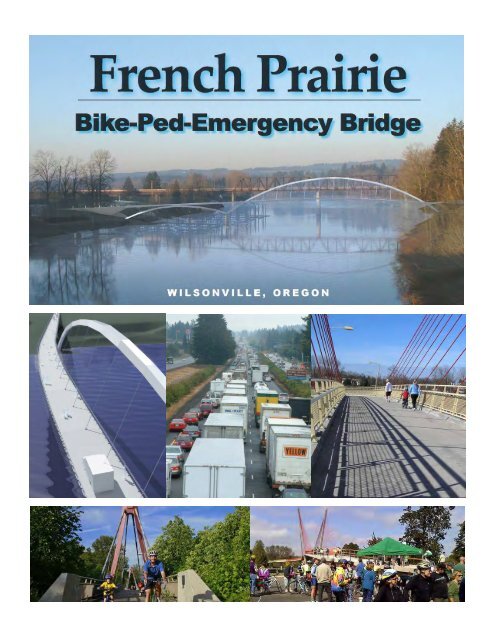
French Prairie Bridge - City of Wilsonville
French Prairie Bridge - City of Wilsonville
French Prairie Bridge - City of Wilsonville

You also want an ePaper? Increase the reach of your titles
YUMPU automatically turns print PDFs into web optimized ePapers that Google loves.
Fre ench <strong>Prairie</strong> P e<br />
Bike-P Ped<br />
Emerg E ency<br />
Bridg ge<br />
Brie efing Bookle B et<br />
______________ _________<br />
March 2012 2<br />
Tablee<br />
<strong>of</strong> Conttents<br />
1. Summary<br />
<strong>of</strong> Key AAttributes:<br />
Emergenccy<br />
Link forr<br />
I-5<br />
Historical Context & Topograpphy<br />
Regional TTrail<br />
Connnections<br />
2. MMedia<br />
Covverage:<br />
Articles<br />
Opinion EEditorials<br />
3. Supporterrs:<br />
Governmeents<br />
Organizattions<br />
4. MMaster<br />
Plaan<br />
Excerppts:<br />
1993 Bicyycle<br />
and Peedestrian<br />
1994 Parkks<br />
& Recreation<br />
2007 Bicyycle,<br />
Pedesstrian<br />
and Transit<br />
5. Public<br />
Involvementt:<br />
Master Plaanning<br />
Effforts<br />
History <strong>of</strong>f<br />
Public Inpput<br />
Planning Commission<br />
Metro MTIIP<br />
Award PProcess
1. Summary <strong>of</strong> Key Attributes:<br />
Emergency Link for I-5<br />
Historical Context & Topography<br />
Regional Trail Connections
<strong>French</strong> <strong>Prairie</strong> <strong>Bridge</strong><br />
Regional Significance<br />
CORVALLIS<br />
Champoeg State Park<br />
EUGENE<br />
ALBANY<br />
SALEM<br />
k<br />
see<br />
inset<br />
map<br />
w i l s o n v i l l e , o r e g o n<br />
PORTLAND<br />
WILSONVILLE<br />
k<br />
Willamette Valley Scenic Bikeway Route<br />
Tonquin Trail Regional Trail<br />
<strong>French</strong> <strong>Prairie</strong> Bicycle/Pedestrian <strong>Bridge</strong><br />
Reconnecting the missing, historic<br />
Willamette River link <strong>of</strong> the Portland<br />
area with the Willamette Valley<br />
Key Attributes <strong>of</strong> the Proposed<br />
<strong>French</strong> <strong>Prairie</strong> <strong>Bridge</strong> at wilsonville<br />
• Historic route reestablished at Boones Ferry crossing,<br />
linking the <strong>French</strong> <strong>Prairie</strong> region <strong>of</strong> the north Willamette<br />
Valley to the greater Portland metro area.<br />
• Safe bicycle and pedestrian access across the Willamette<br />
River without the hazards <strong>of</strong> using I-5.<br />
• Improved connectivity between the Willamette Valley<br />
Scenic Bikeway and new Portland area Tonquin Trail.<br />
• Emergency access to highway accidents for police, fire and<br />
safety vehicles responding to incidents occurring on I-5.<br />
• Tourism development opportunities featuring <strong>French</strong><br />
<strong>Prairie</strong>, the Willamette River Greenway, Champoeg State<br />
Heritage Park and “Oregon Wine Country.”<br />
• Practical, cost-effective transportation solution with<br />
multiple public benefits.<br />
For more information, contact the <strong>City</strong> <strong>of</strong> <strong>Wilsonville</strong>,<br />
Public & Government Affairs Section, at 503-570-1505<br />
1 - 1
Critical<br />
Currently, when incidents occur near Boone urrently, when incidents occur near Boone<br />
Historical safe, Multi-Modal<br />
<strong>Bridge</strong>, Interstate-5 and the entire surrounding<br />
Transportation freeway system shut link down for hours. With Connectivity<br />
freeway system shut down for hours. With<br />
restoration<br />
an average daily traffic volume <strong>of</strong> 120,000 vehicles,<br />
In addition this interstate tocorridor providing - also a predominant seamless truck<br />
this interstate corridor - also a predominant truck route - can become a regional bottleneck. The<br />
Theroute <strong>French</strong> - can <strong>Prairie</strong> become <strong>Bridge</strong> a regional will bottleneck. pro- The connectivity between multi-use<br />
vide <strong>French</strong> the missing <strong>Prairie</strong> <strong>Bridge</strong> linkwould to restore serve as aa<br />
rapid incident trail systems, the <strong>French</strong> <strong>Prairie</strong><br />
seamless, response non-highway system, allowing connection<br />
for authorized vehicles <strong>Bridge</strong> to will also<strong>French</strong> provide <strong>Prairie</strong> connec- <strong>Bridge</strong><br />
between flow around Portland freeway and incidents. Eugene. The The bridge will tions give to the Westside Water Trail Express Connections<br />
ODOT and other responsible authorities the ability to<br />
bridge will link the metro regional Service (WES) at the <strong>Wilsonville</strong><br />
ilsonville is well positioned to take advantage the Willamette River, providing a great opportunity to<br />
clean up faster; and police, fire, and other emergency <strong>of</strong> its regional location as the “Gateway” to the reconnect residents <strong>of</strong> the region with the river. Existing<br />
always be available and commandeerable as an<br />
Tonquin vehicles Trail will have with faster the access Champoeg Commuter WPortland<br />
Metro Area and to Rail serve as a major Station, access locations in <strong>Wilsonville</strong> with include Memorial Park and<br />
to incidents. At water $20 trail destination and stop over point. Situated Boones Ferry Park, while additional access points might<br />
emergency utility.<br />
between two major state parks — Champoeg and Molalla be feasible at Meridian Landing, the Water Treatment<br />
Trail, million, and the to cost-effective the Willamette <strong>French</strong> Val- <strong>Prairie</strong> <strong>Bridge</strong> service — <strong>Wilsonville</strong> is a logical will beginning refueling point for float trips in Plant, and Fall Metro property. 2008. The<br />
down the Willamette River. Currently, both Champoeg<br />
Opportunities exist to develop facilities that foster<br />
and Molalla provide entry and exit opportunities for<br />
leyalways Scenic be Bikeway. available and Building commandeerable the as bridge an also facilitates safe entry to access the river for non-motorized towatercraft and at<br />
water trail users. Day use facilities are available at both<br />
the Boones Ferry Park terminus <strong>of</strong> the <strong>Bridge</strong>. While<br />
locations, and Champoeg also has yurts, cabins, and three<br />
formalizing a connection to the river, there is an<br />
<strong>French</strong> emergency <strong>Prairie</strong> utility.<br />
group tent areas to provide overnight accommodations<br />
<strong>Bridge</strong> will connect from the Willamette opportunity River to develop a park Water<br />
and river access facility<br />
for water trail users.<br />
that celebrates the historic uses <strong>of</strong> the River. This site<br />
Current east-west travel routes in <strong>Wilsonville</strong> provide <strong>of</strong>fers opportunities to develop a possible storage<br />
the Portland metropolitan area to Trail, which stretches from Eugene<br />
little opportunity for people to know that they are<br />
facility. It also provides excellent economic development<br />
traveling along a river corridor. Businesses and residential opportunities for the Old Town along Boones Ferry Road<br />
developments are situated in such a way that blocks as a tourist and traveler destination spot.<br />
the entire regional trail system <strong>of</strong> to Portland.<br />
visual and physical access to the river. The <strong>French</strong> <strong>Prairie</strong><br />
<strong>Bridge</strong> will create a strong link to and along<br />
the Willamette Valley.<br />
Regional Trail Connections<br />
The proposed location <strong>of</strong> the<br />
<strong>French</strong> <strong>Prairie</strong> <strong>Bridge</strong> is at the site<br />
<strong>of</strong> Boones Ferry, which operated<br />
from 1847 to 1954. Founded by<br />
the grandson <strong>of</strong> famous explorer<br />
Daniel Boone, the ferry and Boones<br />
Ferry Road were key components<br />
<strong>of</strong> a major land-based thoroughfare<br />
in pioneer times that linked fledging<br />
Portland with the pre-territorial<br />
government at Champoeg, and<br />
later the state capital <strong>of</strong> Salem.<br />
<strong>French</strong> <strong>Prairie</strong> <strong>Bridge</strong><br />
Emergency Bike-Ped-emergency <strong>French</strong> <strong>Prairie</strong> <strong>Bridge</strong><br />
Link for I-5 <strong>Bridge</strong><br />
C<br />
<strong>French</strong> <strong>Prairie</strong><br />
<strong>Bridge</strong>, Interstate-5 and the entire surrounding<br />
an average daily traffic volume <strong>of</strong> 120,000 vehicles,<br />
<strong>French</strong> <strong>Prairie</strong> <strong>Bridge</strong> would serve as a rapid incident<br />
response system, allowing for authorized vehicles to<br />
flow around freeway incidents. The bridge will give<br />
ODOT and other responsible authorities the ability to<br />
clean up faster; and police, fire, and other emergency<br />
vehicles will have faster access to incidents. At $20<br />
million, the cost-effective <strong>French</strong> <strong>Prairie</strong> <strong>Bridge</strong> will<br />
The bridge will permit safe passage<br />
across the Willamette River<br />
for both bicyclists and pedestrians,<br />
who otherwise risk personal safety<br />
if they try to cross over the heavily<br />
trafficked I-5 Boone <strong>Bridge</strong>. The<br />
<strong>French</strong> <strong>Prairie</strong> <strong>Bridge</strong> will be the<br />
only safe bike-ped bridge over the<br />
Willamette River located within a<br />
30-mile (48 km) stretch between<br />
Newberg and Oregon <strong>City</strong>.<br />
interstate Freeway<br />
emergency Utility<br />
Currently, when traffic incidents<br />
occur near Boone <strong>Bridge</strong> in <strong>Wilsonville</strong>,<br />
I-5 and the entire surrounding<br />
freeway system can shut-down<br />
for hours. With an average daily<br />
traffic volume <strong>of</strong> 120,000 vehicles,<br />
this crucial West Coast interstate<br />
corridor—also a predominant truck<br />
route—can become a regional<br />
1 - 2<br />
Emergency Link for I-5<br />
w i l s o n v i l l e , o r e g o n<br />
bottleneck, impacting traffic<br />
throughout the Portland metro and<br />
North Willamette Valley regions.<br />
The <strong>French</strong> <strong>Prairie</strong> <strong>Bridge</strong> would<br />
serve as a rapid-incident, emergency<br />
response system, allowing<br />
authorized vehicles access to<br />
an incident on the freeway. The<br />
bridge will give ODOT and other<br />
responsible authorities the ability<br />
to clean-up faster; and police, fire,<br />
and other emergency vehicles will<br />
have better access to incidents.<br />
At $20 million, the cost-effective<br />
<strong>French</strong> <strong>Prairie</strong> <strong>Bridge</strong> will always<br />
be available for this purpose and<br />
will be fully commandeerable by<br />
emergency services personnel.<br />
Contextually and<br />
environmentally<br />
sensitive<br />
The <strong>French</strong> <strong>Prairie</strong> <strong>Bridge</strong> is designed<br />
to preserve the surrounding<br />
riparian area and to complement<br />
the design <strong>of</strong> nearby highway and<br />
train bridges. The foundations <strong>of</strong><br />
the bridge will be at higher elevations,<br />
and the bridge will touch<br />
down gently in a non-sensitive<br />
portion <strong>of</strong> the river channel. With<br />
graceful horizontal and vertical<br />
curves, the design <strong>of</strong> the bridge<br />
suggests the movement <strong>of</strong> skipping<br />
stones across the river.<br />
Rev. 4/4/2008
Restoring<br />
a Critical<br />
Transportation<br />
Link in the<br />
Willamette Valley<br />
<strong>French</strong> <strong>Prairie</strong> <strong>Bridge</strong><br />
1 - 3
Interstate Freeway Emergency Utility<br />
Currently, when incidents occur near Boone <strong>Bridge</strong>,<br />
Interstate-5 and the entire surrounding freeway<br />
system shut down for hours. With an average daily<br />
traffic volume <strong>of</strong> 120,000 vehicles, this interstate<br />
corridor - also a predominant truck route - can<br />
become a regional bottleneck. The <strong>French</strong> <strong>Prairie</strong><br />
<strong>Bridge</strong> would serve as a rapid incident response<br />
system, allowing for authorized vehicles to flow<br />
around freeway incidents. The bridge will give ODOT<br />
1 - 4<br />
and other responsible authorities the ability to clean<br />
up faster; and police, fire, and other emergency<br />
vehicles will have faster access to incidents. At $20<br />
million, the cost-effective <strong>French</strong> <strong>Prairie</strong> <strong>Bridge</strong><br />
will always be available and commandeerable as an<br />
emergency utility.<br />
Critical Historical Transportation Link<br />
Restoration<br />
The <strong>French</strong> <strong>Prairie</strong> <strong>Bridge</strong> will provide the missing<br />
link to restore a seamless connection between<br />
Portland and Eugene. The bridge will link the<br />
regional Tonquin Trail with the Champoeg Trail, and<br />
to the Willamette Valley Scenic Bikeway. This will<br />
connect Portland, the largest city in the state, to the<br />
entire regional trail system.<br />
Multi-Modal Connectivity<br />
The bridge will provide critical connections to<br />
<strong>Wilsonville</strong>’s commuter rail (service beginning in Fall<br />
2008), as well as to the Willamette River water trail<br />
system.<br />
Contextually & Environmentally Sensitive<br />
The <strong>French</strong> <strong>Prairie</strong> <strong>Bridge</strong> is designed to preserve<br />
the surrounding riparian area and to complement<br />
the design <strong>of</strong> nearby bridges. The foundations <strong>of</strong> the<br />
bridge will be at higher elevations, and the bridge<br />
will touch down gently in a non-sensitive portion<br />
<strong>of</strong> the river channel. With graceful horizontal and<br />
vertical curves, the design <strong>of</strong> the bridge suggests the<br />
movement <strong>of</strong> skipping stones across the river.<br />
Photo rendering <strong>of</strong> the proposed bridge design.
Currently, when incidents occur near Boone<br />
<strong>Bridge</strong>, Interstate-5 and the entire surrounding<br />
freeway system shut down for hours. With<br />
an average daily traffic volume <strong>of</strong> 120,000 vehicles,<br />
this interstate corridor - also a predominant truck<br />
route - can become a regional bottleneck. The<br />
<strong>French</strong> <strong>Prairie</strong> <strong>Bridge</strong> would serve as a rapid incident<br />
response system, allowing for authorized vehicles to<br />
flow around freeway incidents. The bridge will give<br />
ODOT and other responsible authorities the ability to<br />
clean up faster; and police, fire, and other emergency<br />
vehicles will have faster access to incidents. At $20<br />
million, the cost-effective <strong>French</strong> <strong>Prairie</strong> <strong>Bridge</strong> will<br />
always be available and commandeerable as an<br />
emergency utility.<br />
<strong>French</strong> <strong>Prairie</strong> <strong>Bridge</strong><br />
Emergency Link for I-5<br />
1 - 5
Emergency Link for I-5<br />
1 - 6
<strong>Wilsonville</strong> is uniquely sited as a result <strong>of</strong><br />
regional geology. With the Chehalem<br />
Mountains to the northwest and the basalt<br />
cliffs to the northeast, it is the only direct connection<br />
to Portland across the broad Willamette River.<br />
In 1846, Alphonso Boone immigrated to Oregon via<br />
the Applegate Trail with his large family. By 1847,<br />
using local Tuality Indians as oarsmen, the family had<br />
established Boone’s Ferry. The thriving community<br />
<strong>of</strong> Boone’s Landing, genesis <strong>of</strong> <strong>Wilsonville</strong>, quickly<br />
sprang up on the Willamette River’s north shore.<br />
For 107 years, ferries crossed the Willamette River<br />
carrying thousands<br />
<strong>of</strong> horses, cows,<br />
buggies,<br />
<strong>French</strong> <strong>Prairie</strong> <strong>Bridge</strong><br />
Historical Context & Topography<br />
1 - 7<br />
automobiles, and people. Jesse Boone operated<br />
the ferry until his death in 1872. The State <strong>of</strong><br />
Oregon assumed control <strong>of</strong> the ferry during the<br />
early 1900’s, and by the 1950’s, a cabledrawn vessel<br />
carried up to 12 cars per crossing. Boone’s Ferry was<br />
decommissioned in 1954, shortly after completion <strong>of</strong><br />
the Boone <strong>Bridge</strong>.<br />
Other ferry locations in the region were similarly<br />
located in areas where the topography allowed.<br />
Crossing the Willamette River in many locations has<br />
historically been a challenge due to the steep terrain<br />
and sensitive ecosystems along and in the river.
Historical Context & Topography<br />
1 - 8
The Willamette River separates the beautiful upper<br />
Willamette Valley, known as <strong>French</strong> <strong>Prairie</strong>, from<br />
the Portland Metropolitan urban area. Throughout<br />
<strong>French</strong> <strong>Prairie</strong> and along the banks <strong>of</strong> the Willamette<br />
River, there are plentiful recreation opportunities for<br />
visitors and residents alike. Every year, the reputation<br />
<strong>of</strong> <strong>French</strong> <strong>Prairie</strong> grows as a world-class recreational<br />
bicycling destination, increasing tourism opportunities,<br />
especially for Clackamas and Marion Counties.<br />
Other bicycle and pedestrian infrastructure is planned or<br />
in place to take advantage <strong>of</strong> this trend. The Willamette<br />
Valley Scenic Bikeway was recently completed to bring<br />
pedestrians and cyclists from Eugene north to the<br />
Willamette River at Champoeg State Park. Commuter<br />
Rail is now under construction that will bring pedestrians<br />
and cyclists south from the MAX line in Beaverton to<br />
the current southern terminus in <strong>Wilsonville</strong>, near the<br />
Willamette River. Metro’s long-planned Tonquin Trail is<br />
now funded and ready for construction. It will provide a<br />
scenic bike path that connects the Tualatin River, south<br />
through Tualatin and <strong>Wilsonville</strong>, to the Willamette River.<br />
The Willamette River is a wonderfully attractive natural<br />
resource, but it also creates a major barrier to pedestrians<br />
and cyclists traveling between the valley and the<br />
<strong>French</strong> <strong>Prairie</strong> <strong>Bridge</strong><br />
Regional Trail Connections<br />
1 - 9<br />
metro region. The lack <strong>of</strong> any river crossing other than<br />
Interstate-5 at Boone <strong>Bridge</strong> forces cyclists to take<br />
significant risks by traveling on a six-lane freeway with no<br />
separation from high-speed trucks and cars. The ability<br />
to safely walk or bike to places south or north <strong>of</strong> the river<br />
does not currently exist.<br />
The <strong>French</strong> <strong>Prairie</strong> <strong>Bridge</strong> will be a landmark entry point,<br />
both to the Willamette Valley and to the Portland metro<br />
region. It is fitting that it cross the river at Boones Ferry<br />
Landing, drawing on the heritage <strong>of</strong> this place as the<br />
historical crossing point before the interstate system was<br />
built.<br />
The <strong>French</strong> <strong>Prairie</strong> <strong>Bridge</strong> will finally provide safe and<br />
convenient passage across the Willamette River. It takes<br />
advantage <strong>of</strong> existing public investments north and<br />
south <strong>of</strong> the river by making that critical connection for<br />
the Tonquin Trail, the Champoeg Trail, the<br />
Willamette Valley Scenic Bikeway, and<br />
for cyclists traveling by Commuter Rail.<br />
It will serve as an impressive gateway<br />
to <strong>French</strong> <strong>Prairie</strong> while creating a<br />
fully integrated regional trail<br />
system for Portland and the<br />
Willamette Valley.
Regional Trail Connections<br />
1 - 10
<strong>Wilsonville</strong> is well positioned to take advantage<br />
<strong>of</strong> its regional location as the “Gateway” to the<br />
Portland Metro Area and to serve as a major<br />
water trail destination and stop over point. Situated<br />
between two major state parks — Champoeg and Molalla<br />
— <strong>Wilsonville</strong> is a logical refueling point for float trips<br />
down the Willamette River. Currently, both Champoeg<br />
and Molalla provide entry and exit opportunities for<br />
water trail users. Day use facilities are available at both<br />
locations, and Champoeg also has yurts, cabins, and three<br />
group tent areas to provide overnight accommodations<br />
for water trail users.<br />
Current east-west travel routes in <strong>Wilsonville</strong> provide<br />
little opportunity for people to know that they are<br />
traveling along a river corridor. Businesses and residential<br />
developments are situated in such a way that blocks<br />
visual and physical access to the river. The <strong>French</strong> <strong>Prairie</strong><br />
<strong>Bridge</strong> will create a strong link to and along<br />
<strong>French</strong> <strong>Prairie</strong> <strong>Bridge</strong><br />
Water Trail Connections<br />
1 - 11<br />
the Willamette River, providing a great opportunity to<br />
reconnect residents <strong>of</strong> the region with the river. Existing<br />
access locations in <strong>Wilsonville</strong> include Memorial Park and<br />
Boones Ferry Park, while additional access points might<br />
be feasible at Meridian Landing, the Water Treatment<br />
Plant, and Metro property.<br />
Opportunities exist to develop facilities that foster<br />
safe entry to the river for non-motorized watercraft at<br />
the Boones Ferry Park terminus <strong>of</strong> the <strong>Bridge</strong>. While<br />
formalizing a connection to the river, there is an<br />
opportunity to develop a park and river access facility<br />
that celebrates the historic uses <strong>of</strong> the River. This site<br />
<strong>of</strong>fers opportunities to develop a possible storage<br />
facility. It also provides excellent economic development<br />
opportunities for the Old Town along Boones Ferry Road<br />
as a tourist and traveler destination spot.
Water Trail Connections<br />
1 - 12
<strong>French</strong> <strong>Prairie</strong> <strong>Bridge</strong><br />
Contextual & Environmental Sensitivity<br />
The <strong>French</strong> <strong>Prairie</strong> <strong>Bridge</strong> is designed to preserve the surrounding riparian area and to<br />
complement the design <strong>of</strong> nearby bridges. The foundations <strong>of</strong> the bridge will be at higher<br />
elevations, and the bridge will touch down gently in a non-sensitive portion <strong>of</strong> the river<br />
channel. With graceful horizontal and vertical curves, the design <strong>of</strong> the bridge suggests the<br />
movement <strong>of</strong> skipping stones across the river.<br />
1 - 13<br />
Photo rendering <strong>of</strong> the <strong>French</strong> <strong>Prairie</strong> <strong>Bridge</strong>
Description<br />
A separated bicycle and pedestrian bridge spanning the<br />
Willamette River would greatly improve the biking and<br />
walking experience <strong>of</strong> all users while serving as a gateway to<br />
<strong>Wilsonville</strong> and the Portland metro region for northbound<br />
travelers and the Willamette Valley for southbound travelers.<br />
Currently, bicyclists and pedestrians are expected to use the<br />
freeway bridge deck when they wish to cross the Willamette<br />
River. For most users, this is a frightening experience at best.<br />
Instead <strong>of</strong> biking or walking, people choose to drive over the<br />
river and start bicycling from the south side.<br />
The installation <strong>of</strong> a separated bridge also creates the<br />
opportunity to connect people with the river, while providing<br />
economic development opportunities for businesses in Old<br />
Town and other parts <strong>of</strong> <strong>Wilsonville</strong>. Furthermore, the bridge<br />
will strengthen regional connections by providing a linkage to<br />
the regional commuter rail station scheduled to begin<br />
operations in 2008.<br />
The bridge would also emphasize <strong>Wilsonville</strong>'s dedication as a<br />
bicycle and pedestrian friendly environment while creating<br />
stronger regional connections.<br />
Type/Width Length<br />
Shared-use bridge / 14 ft Approximately one mile<br />
Ownership<br />
<strong>City</strong> <strong>of</strong> <strong>Wilsonville</strong><br />
Key Land Uses/Destinations<br />
Serves residents and visitors <strong>of</strong> <strong>Wilsonville</strong>. Connects<br />
<strong>Wilsonville</strong> with Charbonneau, Champoeg, Willamette Valley<br />
Scenic Bikeway, and the southern Willamette Valley.<br />
Issues<br />
• Identifying the<br />
appropriate bridge<br />
location and negotiating<br />
with property owners.<br />
• Ensuring the privacy and<br />
safety <strong>of</strong> nearby<br />
residences and<br />
businesses.<br />
Planning-Level Cost Estimate<br />
$12 - 20 million<br />
2. Recommended Bicycle and Pedestrian Network<br />
R5: Willamette River Crossing<br />
• Creating safe,<br />
comfortable access from<br />
both the north and<br />
south to ensure high<br />
usage <strong>of</strong> the bridge.<br />
Bicycle and pedestrian bridge near a rail bridge,<br />
Arizona<br />
Sundial bridge in Redding, CA<br />
Suspension bridge in Waco, TX<br />
<strong>Wilsonville</strong> Bicycle and Pedestrian Master Plan 29<br />
1 - 14
Accident at I-5 Boone <strong>Bridge</strong> in <strong>Wilsonville</strong><br />
Brings Portland Traffic to a Stand-still for Hours<br />
Southbound I-5 traffic congestion backed-up through downtown Portland and<br />
impacted I-205 and Hwy 217, bringing the metro region to gridlock for most <strong>of</strong> the day.<br />
Note large<br />
number <strong>of</strong><br />
trucks on<br />
south Metro<br />
I-5 corridor<br />
I-5 Major <strong>Bridge</strong>s Daily Traffic Volume<br />
TOTAL Truck Truck<br />
I-5 <strong>Bridge</strong> VOLUME % Vol<br />
Interstate CRC 126,600 18% 22,788<br />
Boone <strong>Bridge</strong> 122,300 28% 34,244<br />
Vol Difference -4,300 11,456<br />
% Difference -3.5% 33.5%<br />
Looking at southbound I-5 from Boeckman Road overpass, Sept. 2006<br />
1 - 15<br />
Cars and trucks block<br />
freeway shoulder,<br />
preventing emergencyservices<br />
and clean-up<br />
crews from reaching<br />
incident faster, further<br />
increasing traffic<br />
congestion and delay.
2. Media Coverage:<br />
Articles<br />
Opinion Editorials
Media Coverage <strong>of</strong> <strong>French</strong> <strong>Prairie</strong> Bike-Ped-Emergency <strong>Bridge</strong><br />
over the Willamette River at <strong>Wilsonville</strong>, Oregon<br />
As <strong>of</strong> February 2012<br />
• “<strong>City</strong> looks at Willamette River bicycle crossing: <strong>Bridge</strong> is just one<br />
idea among several to help improve local livability,” article,<br />
<strong>Wilsonville</strong> Spokesman, May 24, 2006<br />
• “Bicyclists seek new Willamette crossing — Touring: A bike bridge<br />
near <strong>Wilsonville</strong> would give riders better access to rest <strong>of</strong> valley,”<br />
article, The Oregonian, May 30, 2006<br />
• “Bike bridge would minimize impacts,” Point <strong>of</strong> View by Michelle<br />
Ripple, <strong>Wilsonville</strong> Spokesman, June 14, 2006<br />
• “<strong>Bridge</strong> gains traction,” article, <strong>Wilsonville</strong> Spokesman, April 2007<br />
• “<strong>French</strong> <strong>Prairie</strong> <strong>Bridge</strong> proposal gathers steam: <strong>Wilsonville</strong> - Span<br />
backers seek funds for the bike, pedestrian and emergency route,”<br />
article, The Oregonian, July 24, 2008<br />
• “Getting out <strong>of</strong> Portland to the beginning <strong>of</strong> the Willamette Valley<br />
Scenic Bikeway,” article, The Oregonian/OregonLive, June 3, 2010<br />
• “Not everyone is in favor <strong>of</strong> an Old Town bike/ped bridge,” opinion<br />
editorial, <strong>Wilsonville</strong> Spokesman, Feb. 7, 2012<br />
• “In favor <strong>of</strong> the bike/pedestrian bridge,” opinion editorial, <strong>Wilsonville</strong><br />
Spokesman, Feb. 22, 2012<br />
• “A bike/pedestrian bridge benefits <strong>Wilsonville</strong>,” opinion editorial,<br />
<strong>Wilsonville</strong> Spokesman, Feb. 22, 2012<br />
2-1
2-2
2-3
Bike bridge would minimize impacts<br />
Point <strong>of</strong> View by Michelle Ripple<br />
June 14, 2006<br />
As chair <strong>of</strong> the Advisory<br />
Committee for Master Planning<br />
I’d like to answer the questions<br />
Michelle Dempsey raised in last<br />
week’s Point <strong>of</strong> View. Ms.<br />
Dempsey asked some excellent<br />
questions; some <strong>of</strong> the same ones<br />
we asked on the committee.<br />
First let me emphasize that the<br />
notion <strong>of</strong> a bicycle/pedestrian<br />
bridge is at a very preliminary<br />
stage. It was put into the plans<br />
based on overwhelming input we<br />
received from the public saying<br />
they want greater access to the<br />
Willamette River and a way to<br />
cross it.<br />
We started the planning process<br />
by gathering public input at open<br />
houses, stakeholder interviews,<br />
charettes, from public testimony<br />
and with a survey mailed to<br />
<strong>Wilsonville</strong> residents. The<br />
proposed bridge has generated<br />
enthusiasm and attention from<br />
the press, State Parks, the<br />
Bicycle Transportation Alliance<br />
and citizens throughout the<br />
region.<br />
Because <strong>of</strong> its regional impact<br />
there is the potential to get<br />
funding to build the bridge from<br />
many sources.<br />
The bridge that the ACMP has<br />
proposed as part <strong>of</strong> the<br />
Bicycle/Pedestrian Master Plan is<br />
envisioned to go from cityowned<br />
land at the foot <strong>of</strong> Boones<br />
Ferry Rd. to county-owned land<br />
at the marina across the river.<br />
Many organized bike tours<br />
originate here in <strong>Wilsonville</strong> and<br />
tour the Willamette Valley and<br />
wine country south <strong>of</strong> the river.<br />
<strong>Wilsonville</strong> is uniquely<br />
positioned as the gateway to the<br />
Willamette Valley both<br />
southbound and northbound. We<br />
have the hotels, restaurants and<br />
services that bike tour groups<br />
need, but no safe way to cross<br />
the Willamette.<br />
In a few years, the Tonquin Trail,<br />
a major regional bike trail, is<br />
scheduled to connect <strong>Wilsonville</strong><br />
to the Tualatin River through the<br />
wildlife refuge near Sherwood.<br />
Additionally, in 2008 commuter<br />
rail will come to <strong>Wilsonville</strong>.<br />
Both <strong>of</strong> these will bring the<br />
opportunity for cyclists from<br />
throughout the region to access<br />
<strong>Wilsonville</strong> without having to<br />
drive cars.<br />
With a safe way to cross the<br />
Willamette, cyclists would be<br />
able to access the entire south<br />
Willamette Valley and <strong>French</strong><br />
<strong>Prairie</strong> areas.<br />
Perhaps one <strong>of</strong> the most<br />
important functions <strong>of</strong> the<br />
proposed bridge is to provide<br />
emergency vehicle access so<br />
emergency personnel can clear<br />
problems on I-5 more quickly. It<br />
will also provide emergency<br />
access to Charbonneau whenever<br />
the Boone <strong>Bridge</strong> is not<br />
accessible. This will give our<br />
emergency medical, police and<br />
fire crews a way to get to<br />
Charbonneau residents if I-5 is<br />
impassable. It absolutely has not<br />
been planned to provide an<br />
alternate route for motorists.<br />
The ACMP hasn’t directly<br />
addressed revitalizing the Old<br />
Town neighborhood, which is<br />
why we did not put sidewalks for<br />
Old Town into the plan. We have<br />
included improvements to the<br />
Old Methodist Church and<br />
2-5<br />
Boones Ferry Park, including a<br />
non-motorized boat access, the<br />
proposed bike/pedestrian bridge<br />
and river viewpoints. The<br />
viewpoints will be designed to be<br />
built with minimal or no impact<br />
to the Willamette Greenway.<br />
The <strong>Wilsonville</strong> <strong>City</strong> Council has<br />
a well-established reputation for<br />
protecting significant trees<br />
wherever possible and there are<br />
no plans for removal <strong>of</strong> any trees<br />
or vegetation.<br />
The improvements to the Old<br />
Town area are specifically<br />
designed not to bring in<br />
additional vehicular traffic. The<br />
ACMP is very aware <strong>of</strong> and<br />
sensitive to the Old Town<br />
residents’ desires to maintain the<br />
pedestrian-friendly character <strong>of</strong><br />
their neighborhood.<br />
All <strong>of</strong> these proposals are still<br />
being reviewed, along with<br />
everything in the three draft<br />
plans. There is continuing<br />
opportunity for public input on<br />
the Bicycle/Pedestrian, Parks and<br />
Recreation or Transit Master<br />
Plans. The next public meeting<br />
will be at the June 14 meeting <strong>of</strong><br />
the Planning Commission; and,<br />
<strong>of</strong> course, you may call or send<br />
your written comments to the<br />
city or me at anytime.<br />
You can reach Chris Neamtzu,<br />
manager <strong>of</strong> long range planning<br />
at 503-570-1574 or me, Michelle<br />
Ripple, at 503-682-7896.<br />
Michelle Ripple was appointed to<br />
the <strong>Wilsonville</strong> <strong>City</strong> Council in<br />
December. Her term runs<br />
through the end <strong>of</strong> the year.
<strong>Bridge</strong> gains traction<br />
By David Jagernauth<br />
April 04, 2007<br />
At this rate, Mayor Charlotte Lehan might want to buy a second home in Washington, D.C.<br />
Lehan has traveled to the nation’s capital twice in as many weeks. The first time was part <strong>of</strong> an<br />
annual trek for federal dollars on behalf <strong>of</strong> the city.<br />
For the second trip, Lehan was invited by a coalition <strong>of</strong> Oregon bicycle and tourism advocates to<br />
speak about a vision for a bicycle and pedestrian bridge over the Willamette River.<br />
―We were pleasantly surprised, and flattered, how quickly it rose to the top <strong>of</strong> their list <strong>of</strong><br />
statewide priorities,‖ Lehan said.<br />
The idea has sparked buzz from leaders <strong>of</strong> a number <strong>of</strong> different interest groups — not only<br />
biking and tourism, but also state parks, emergency management and transportation.<br />
The idea for a bike bridge over the river came out <strong>of</strong> <strong>Wilsonville</strong>’s recent master planning<br />
process for bikes, parks, and mass transit. One concern heard time and time again from the<br />
public was a lack <strong>of</strong> access across the Willamette.<br />
Anybody wishing to travel to Charbonneau, Champoeg State Park, or other places south <strong>of</strong> the<br />
river, or those south wishing to come north, have only one option, and a dangerous one at that –<br />
the Interstate 5 Boone <strong>Bridge</strong>.<br />
The bridge would double as an alternative crossing route for emergency vehicles. Given the<br />
tendency for the Boone <strong>Bridge</strong> to back up during an accident, and the vulnerability <strong>of</strong> the<br />
Charbonneau population, an emergency route over the river is desperately needed, she said.<br />
At $20 million, the estimated cost <strong>of</strong> the bridge is substantial, but cost-effective, Lehan said. And<br />
it could potentially draw from numerous pots <strong>of</strong> money, not just transportation.<br />
The mayor emphasized that her trip to Washington was merely to present the bridge idea to the<br />
local legislative delegation and not to formally request money.<br />
Lehan said she hopes that will happen during the next funding cycle, but only for the cost <strong>of</strong><br />
preliminary design and planning.<br />
Several things must happen in the meantime. The first step is to develop a task force this year<br />
made up <strong>of</strong> interested parties from across the region including Clackamas County, ODOT, the<br />
parks, police and fire departments, and others.<br />
―It really isn’t a <strong>Wilsonville</strong> bridge, it is a regional project,‖ Lehan said. ―It has a much wider<br />
appeal.‖<br />
The task force would decide whether to recommend the project for Metro’s Regional<br />
Transportation Plan, a necessary step before requesting federal dollars.<br />
―Everybody understands that this is a big project that won’t happen tomorrow,‖ Lehan said. ―But<br />
for a project that just a year ago nobody was talking about it has gotten legs quickly, in several<br />
quarters.‖<br />
2-6
<strong>French</strong> <strong>Prairie</strong> <strong>Bridge</strong> proposal gathers steam<br />
Thursday, July 24, 2008<br />
<strong>Wilsonville</strong> - Span backers seek funds for the bike, pedestrian and emergency route<br />
By WENDY OWEN<br />
The Oregonian Staff<br />
As the price <strong>of</strong> fuel climbs, <strong>Wilsonville</strong> may find its<br />
idea for a bike, pedestrian and emergency access<br />
bridge across the Willamette River at the forefront <strong>of</strong> a<br />
movement.<br />
Recreational trails are likely to grow as commuter<br />
paths. Anecdotally, the numbers are already rising,<br />
and the bridge would help link pedalers and walkers<br />
south <strong>of</strong> the river to the Westside Express Service<br />
commuter rail station in <strong>Wilsonville</strong>.<br />
A rendering shows the proposed <strong>French</strong><br />
The city sent an application to the Metro regional <strong>Prairie</strong> <strong>Bridge</strong>, which would be in<br />
government last week to be considered for $1.25 <strong>Wilsonville</strong>’s Old Town neighborhood.<br />
million in transportation-improvement funding for a<br />
preliminary study <strong>of</strong> the proposed bridge site to determine if it is feasible.<br />
The idea started last year with the city's work on its parks and recreation<br />
master plan, said Mark Ottenad, <strong>Wilsonville</strong> public affairs director.<br />
Originally, plans called for hanging the bridge alongside the Interstate 5<br />
Boone <strong>Bridge</strong>, which is between the <strong>Wilsonville</strong> and Canby exits, or<br />
connecting it to the nearby railroad bridge.<br />
But <strong>Wilsonville</strong> Mayor Charlotte Lehan pushed for a stand-alone span, with<br />
space for emergency vehicles, at <strong>Wilsonville</strong>'s Old Town neighborhood<br />
along Boones Ferry Road.<br />
"If we're going to do it, we're going to do it right," she said.<br />
The only option in the area now for bikers and walkers who want to cross<br />
the Willamette River is the shoulder <strong>of</strong> the Boone <strong>Bridge</strong>, alongside six<br />
lanes <strong>of</strong> traffic traveling 65 mph. An average 120,000 vehicles pass through<br />
the area daily.<br />
The Boone <strong>Bridge</strong> also is the only option for ambulances, firefighters and<br />
police to respond to area accidents that tie up the freeway. The new bridge,<br />
dubbed the <strong>French</strong> <strong>Prairie</strong> <strong>Bridge</strong>, would serve as an emergency bypass.<br />
"A closed bridge or impassible road can significantly impair our ability to<br />
respond efficiently," Tualatin Valley Fire & Rescue Chief Jeffrey Johnson<br />
2-7
wrote in a letter <strong>of</strong> support for the new bridge. "In medical emergencies or during a fire, minutes can<br />
mean the difference between life and death."<br />
The multiple uses for the bridge probably will make it more appealing to state and federal agencies to<br />
fund, Lehan said.<br />
It is projected to cost $20 million and, so far, has the support <strong>of</strong> U.S. Sen. Gordon Smith, R-Ore., among<br />
others.<br />
Ideally, the span would cross the river where the Boones Ferry carried folks from <strong>French</strong> <strong>Prairie</strong> to oldtown<br />
<strong>Wilsonville</strong> between 1847 and 1954. The location will help control costs because land on both sides<br />
<strong>of</strong> the river is publicly owned and connects to existing roads, Lehan said.<br />
Eventually, the bridge could become a recreational-commuter link between Portland and the southern<br />
Willamette Valley all the way to Eugene.<br />
In addition, Metro's Tonquin Trail for pedestrians and bikes is now funded and moving forward, Ottenad<br />
said. It will eventually connect all the major cities southwest <strong>of</strong> Portland, including Tigard, Sherwood and<br />
Tualatin, to <strong>Wilsonville</strong>.<br />
Lehan said the <strong>French</strong> <strong>Prairie</strong> <strong>Bridge</strong> could be constructed within the next five to eight years, depending<br />
on funding.<br />
©2008 Oregonian<br />
2-8
Getting out <strong>of</strong> Portland to the beginning <strong>of</strong> the<br />
Willamette Valley Scenic Bikeway<br />
Published: Thursday, June 03, 2010<br />
By Terry Richard, The Oregonian<br />
To get out <strong>of</strong> Portland to reach <strong>Wilsonville</strong>, near the beginning <strong>of</strong> the Willamette<br />
Valley Scenic Bikeway, I used Metro's Bike There! map.<br />
From <strong>Wilsonville</strong>, you need to bike across the Willamette River on the Boone <strong>Bridge</strong><br />
(also known as I-5, Ugghh!), take the first exit and follow the Willamette River<br />
upstream to blissful Butteville.<br />
From Butteville you<br />
can connect via the<br />
state park bike path<br />
to Champoeg State<br />
Heritage Area, the<br />
formal starting place<br />
for the Willamette<br />
Valley Scenic<br />
Bikeway. Then, all<br />
you have is 132 miles<br />
<strong>of</strong> riding to Armitage<br />
County Park on the<br />
north edge <strong>of</strong> Eugene.<br />
Terry Richard/The Oregonian<br />
Watch this space over<br />
the next few days for<br />
posts about riding Oregon's first scenic bikeway.<br />
Meanwhile, back in the big city, the <strong>City</strong> <strong>of</strong> Portland is in the process <strong>of</strong> putting<br />
more <strong>of</strong> its neighborhood bike maps online. Jeff Smith <strong>of</strong> the Department <strong>of</strong><br />
Transportation says he hopes to have them ready early this summer. Until then,<br />
look here for Portland's neighborhood bike maps, which can be ordered from<br />
the city or picked up for free at some bike stores.<br />
Here's a link to the <strong>City</strong> <strong>of</strong> Tigard's bike map.<br />
The Ki-a-kuts <strong>Bridge</strong>, opened in 2007, is a pedestrian/bike crossing<br />
between Cook Park in Tigard and Tualatin Community Park in Tualatin.<br />
Here's a link for how to purchase the Clackamas County bike map.<br />
If you don't feel safe biking through Portland to <strong>Wilsonville</strong>, TriMet <strong>of</strong>fers a viable<br />
alternative.<br />
Just take the MAX line to Beaverton Transit Center, then ride WES to<br />
<strong>Wilsonville</strong>.<br />
2-9
The main problem is that WES runs only during the work week and only during<br />
morning and evening commute hours. So you need to plan around it.<br />
Oh, WES has another problem. TriMet has oriented its online WES map with north<br />
going right, usually the direction <strong>of</strong> eastward travel. Don't let it fool you.<br />
Also beware that bikes can be transported on commuter trains, but only if there<br />
is room. Don't count on finding space when you pedal up to the station just before<br />
the last WES train <strong>of</strong> the day departs.<br />
If you miss your WES, <strong>Wilsonville</strong> and<br />
Beaverton have a reasonable bike connection,<br />
mostly on Hall Boulevard and Boones Ferry<br />
Road. Check Metro's Bike There! map for<br />
details.<br />
<strong>Wilsonville</strong> also has a bus system called<br />
SMART (South Metro Area Regional Transit)<br />
that can transport bikes around town and as<br />
far away as Canby and Salem. Look online at<br />
www.ridesmart.com.<br />
-- Terry Richard<br />
© 2012 OregonLive.com. All rights reserved.<br />
2-10<br />
Here are some cool links to bike<br />
maps that will get you around<br />
the metro area.<br />
Metro's Bike There! map is hot<br />
<strong>of</strong>f the presses this spring with a<br />
new cover price <strong>of</strong> $9. You'll<br />
need to buy it, not view it online.<br />
It's edition No. 8.<br />
This map will get you pretty<br />
much from anywhere in the<br />
Metro area to <strong>Wilsonville</strong>, close<br />
to the start <strong>of</strong> the Willamette<br />
Valley Scenic Bikeway.
Not everyone is in favor <strong>of</strong> an Old Town bike/ped bridge<br />
Reader View - Published: 2/7/2012<br />
Rob and Michele Dempsey<br />
Dear <strong>Wilsonville</strong> <strong>City</strong> Councilors:<br />
We are not sure how the Advisory Committee for Master Planning that created the Bike/Ped,<br />
Parks and Transit Master Plans was chosen, but we are unaware that any <strong>of</strong> our neighbors from<br />
the Old Town neighborhood were invited to participate in this discussion, or more specifically,<br />
any who would be directly impacted by the addition <strong>of</strong> an enormous bridge where Boones Ferry<br />
Road dead ends at the river.<br />
As this location was and continues to be seriously considered, or at least continuously mentioned<br />
in the media, we believe it was a gross oversight not to invite at least a few <strong>of</strong> the people to the<br />
table whose lives would be forever changed by a project <strong>of</strong> this magnitude.<br />
During the last Mayor’s tenure more than a few Master Plans were developed with little or no<br />
public input but were instead designed by Metro and approved by strategically appointed local<br />
Boards. Repetitive meetings simply wear the public out.<br />
I guess if you’re not at “the table,” you’re probably “on the menu.” For 12 <strong>of</strong> the last 13 years <strong>of</strong><br />
leadership at the city they were always willing to “listen” but their minds were already made up<br />
long before we got there.<br />
We are happy to hear that the foot <strong>of</strong> Boones Ferry Road was only one location suggested for the<br />
possible site <strong>of</strong> a future bike/pedestrian bridge. We are actually aware that other locations were<br />
suggested, but none seem to be being seriously considered except for this one.<br />
We urge the city to consider all other possibilities and to cross this location <strong>of</strong>f its list. Surely<br />
there must be better options that won’t negatively impact a whole neighborhood.<br />
For the record, this unique area at the end <strong>of</strong> Boones Ferry Road contains the last remaining<br />
green space in our neighborhood. The playground we once had at the old grade school is gone as<br />
is the orchard that has been developed into a parking lot and home to Fred Meyer and many other<br />
establishments.<br />
To pave one more inch on either side <strong>of</strong> Boones Ferry Road where it dead ends at the river<br />
would be a travesty not only to the neighborhood but to its animal denizens. This is an<br />
extraordinary neighborhood that is different from many <strong>of</strong> <strong>Wilsonville</strong>’s other neighborhoods<br />
and one <strong>of</strong> the key factors that makes it unique is this amazing green space; we value this open<br />
space as does the wildlife that this ecosystem sustains.<br />
Much <strong>of</strong> the rest <strong>of</strong> our neighborhood is unattractive and chaotic: from the railroad tracks and<br />
trains that regularly “park” in our backyards, to the odoriferous sewage treatment plant and<br />
constant roar <strong>of</strong> I-5, to the new traffic headaches we must endure as we adjust to our new<br />
business neighbors at the entrance to our neighborhood.<br />
2-11
Our neighborhood deserves to keep this last remaining green space that greatly increases our<br />
neighborhood livability from being turned into a construction zone and then being paved over<br />
with a bridge.<br />
As taxpaying homeowners in <strong>Wilsonville</strong> we also find it exceptional that a bike/pedestrian<br />
bridge is the “single most requested thing” by its citizens. In fact, we don’t believe that. What<br />
about fixing the roads and sidewalks?<br />
With survey results like this we question who the audience was. We know many children who<br />
would love to have a bike bridge, a swimming pool, and a skate park (especially if you<br />
specifically ask them… would you like a bike bridge, a swimming pool, or a skate park) but they<br />
don’t have to pay for these luxuries.<br />
Surely in this economy <strong>Wilsonville</strong> has bigger things to think about than discretionary amenities.<br />
Those include the Boeckman Road “dip” and larger storage for <strong>Wilsonville</strong> Community Sharing<br />
and the Food Bank, among others.<br />
We vote no on the bike/pedestrian bridge - take it out <strong>of</strong> the master plan - regardless <strong>of</strong> its<br />
location but especially if it is sited anywhere in Old Town. We don’t believe that inclusion <strong>of</strong><br />
this project in the master plan was smart planning or prudent fiscal management in the first<br />
place.<br />
The city needs to be more practical with taxpayer’s money and should first fund core services<br />
that protect and care for our most vulnerable citizens. It’s simply too much money to benefit too<br />
few people. Large financial expenditures should be sent to the voters for their approval. If you<br />
are seeking federal matching dollars why not try for something that will boost the economy,<br />
generate long term jobs, or improve our schools.<br />
Sincerely,<br />
Rob and Michele Dempsey<br />
<strong>Wilsonville</strong><br />
2-12
In favor <strong>of</strong> the bike/pedestrian bridge<br />
Reader View - Published: 2/22/2012<br />
By Kate and Jerry Greenfield <strong>of</strong> <strong>Wilsonville</strong><br />
The question is: Would a bicycle/pedestrian/emergency bridge be good for <strong>Wilsonville</strong>?<br />
Opposition to the proposed bicycle/pedestrian/emergency bridge across the Willamette expressed<br />
in the Feb. 8 <strong>Wilsonville</strong> Spokesman seems to be based on some major misconceptions.<br />
The authors refer to an “enormous bridge,” while the design <strong>of</strong> the proposed bridge would be the<br />
opposite — a slim lane <strong>of</strong> pavement extending across the river from existing paved surfaces,<br />
having a minimal impact on the existing environment.<br />
They worry that the bridge would “negatively impact a whole neighborhood.” However, the<br />
street to the river already has bike lanes along sections that are heavily traveled. Beyond the<br />
shopping center, it is a lightly travelled cul-de-sac. While some people in Old Town may worry<br />
about negative impacts in their neighborhood, our experiences riding on bike paths in Oregon,<br />
Massachusetts, Pennsylvania, and Japan indicate the opposite. Bicyclists and hikers tend to be<br />
affluent and environmentally conscious. As long as the only motorized vehicles crossing the<br />
bridge are responding to emergencies, the traffic will be quiet and unobtrusive.<br />
The authors doubt that a bike bridge is desired and at the same time refer to the bridge as a<br />
luxury that we desire but can ill afford. We have desired a bicycle bridge across the Willamette<br />
since we arrived in <strong>Wilsonville</strong> and realized that we would have to cross the dangerous Boone<br />
<strong>Bridge</strong> to ride to the great biking country across the river. Local businesses are likely to desire a<br />
bridge because it would allow <strong>Wilsonville</strong> to play a central role in a countywide network <strong>of</strong><br />
bicycle routes aimed at expanding the flow <strong>of</strong> tourist dollars into our area. Without the bridge in<br />
<strong>Wilsonville</strong>, those tourist dollars are likely to flow to other communities. Some <strong>of</strong> the funding<br />
for the bridge is likely to come from outside <strong>Wilsonville</strong> because <strong>of</strong> its importance for the region.<br />
The location <strong>of</strong> the proposed bridge at the site <strong>of</strong> the old ferry route across the river seems<br />
mysterious to the authors. However, it seems pretty likely that the ferry that carried traffic across<br />
the river from 1847 to 1954 was located at an advantageous crossing point. Preexisting paved<br />
access to the river on both sides would lower the cost <strong>of</strong> the project.<br />
Connecting the Tonquin Trail with biking routes south <strong>of</strong> the river would put <strong>Wilsonville</strong> in the<br />
center <strong>of</strong> a network <strong>of</strong> bicycle routes from the Tualatin River south through the Willamette<br />
Valley. Such assets draw customers for local businesses, create local jobs, and improve the<br />
attractiveness <strong>of</strong> <strong>Wilsonville</strong> to companies looking to locate in desirable communities.<br />
Participants at a recent meeting discussing ways <strong>of</strong> increasing bicycle tourism in Clackamas<br />
County, regarded a bicycle/pedestrian bridge in <strong>Wilsonville</strong> as a very high priority project. It<br />
seems likely that the existence <strong>of</strong> such a bridge would also improve property values in Old<br />
Town. Surely it would restore Old Town’s historic identity as a river crossing point in a quieter<br />
less-trafficked form than the old ferry.<br />
2-13
A bike/pedestrian bridge benefits <strong>Wilsonville</strong><br />
Reader View - Published: 2/22/2012<br />
By Steve Van Wechel <strong>of</strong> <strong>Wilsonville</strong><br />
Before anybody throws the baby out with the bathwater concerning the proposed bicyclepedestrian<br />
bridge (especially any member <strong>of</strong> the city council), it needs to be stated that many<br />
people indeed do want the bridge – including residents <strong>of</strong> Old Town.<br />
The Reader Review in the Feb. 8 Spokesman that spoke against the proposed bridge expresses a<br />
number <strong>of</strong> concerns. Everything listed can be easily addressed and rebutted.<br />
The first concern was that no one in Old Town was included in the decisions that led to the site<br />
that was selected and so they feel it is being forced on them.<br />
The fact is that The Spokesman ran an article indicating the <strong>City</strong> Council was seeking volunteers<br />
to serve on an advisory committee (ACMP) to the pr<strong>of</strong>essionals that were updating three major<br />
city plans including the Bicycle Pedestrian Plan. Everyone had equal opportunity to put their<br />
name in the pot for possible selection. I volunteered, was selected by the city council, and have<br />
lived in Old Town for over 25 years.<br />
The pubic was invited to all ACMP meetings and public members I believe were at each meeting<br />
expressing opinions, etc. The ACMP had a booth at Fun in the Park allowing for input.<br />
I’m not sure how the city could have done more to encourage participation/input. It’s like the<br />
state lottery – the chances <strong>of</strong> winning improve greatly if you choose to participate. Participate at<br />
the time rather than waiting for many years after the winner was announced as is the case with<br />
the negative Feb. 8 article.<br />
The article writer also complains that the Boones Ferry site is the only site being discussed. What<br />
can you say? The decision was made years ago in a very public process. It was adopted by the<br />
ACMP, by various city boards, and finally by the city council itself. Then once in the plan, it has<br />
been included in Metro, regional and state plans. Even the federal government is involved. Does<br />
the writer <strong>of</strong> that Feb 8 article have any concept <strong>of</strong> the behind-the-scenes work that needs to<br />
occur and the amount <strong>of</strong> lead time required to get over a million dollars designated for initial<br />
planning and engineering plans for the bridge (in that location) especially in these economic<br />
times? It’s interesting that it is only after all this, the point is raised about “not in our backyard.”<br />
For general information, the ACMP identified and researched five locations for the bridge.<br />
Through a process <strong>of</strong> elimination, four were tossed out and the Boones Ferry location was<br />
selected.<br />
The writer’s commented on the need for “prudent fiscal management.” – Do you think it would<br />
be prudent fiscal management to purchase two to three riverfront lots in Charbonneau to build a<br />
bridge from Memorial Park and try to connect it to areas south and to the west side via the<br />
2-14
Tonquin Trail or the WES Station, etc.? The other sites were eliminated for their own negative<br />
points. The Boones Ferry site is the only site being discussed because it’s where both ends <strong>of</strong> the<br />
bridge can be built on already owned public property (prudent fiscal management) and can most<br />
easily be connected with connecting access trails.<br />
While I don’t have space to rebut every argument, consider this:<br />
I refer anyone to the several city council-sponsored meetings where it was stated, very loudly,<br />
that <strong>Wilsonville</strong> wants more access to the river and the bridge is a primary concept.<br />
As for fixing potholes and sidewalks, the currently-authorized money coming from the federal<br />
government to <strong>Wilsonville</strong> in 2012 is specifically for planning and engineering purposes and<br />
would not fix a single pothole – nor would it reduce the federal budget correspondingly if the<br />
city should “do a 180” and refuse the money after all the efforts and time it has taken to get it.<br />
Granted, it will take proper planning by city leaders and other involved groups, but the bridge<br />
can represent the biggest, most positive boon the city has ever had – if it is done right.<br />
Potential benefits it can <strong>of</strong>fer include: 1) a safety alternative to the Boone <strong>Bridge</strong> bottleneck, 2)<br />
huge economic benefit (if planned for such from the beginning), 3) public/private partnership<br />
such as with Bonneville Power for the power lines that cross the river (at this selected site), 4)<br />
green transportation options and even green energy production potential, 5) homeland security<br />
interests, 6) national Department <strong>of</strong> Transportation interests, 7) a wonderful opportunity to<br />
emphasize local and regional history, and cultural history, 8) cooperation <strong>of</strong> all five levels <strong>of</strong><br />
government including Metro (and public/private partnerships), 9) educational opportunities, 10)<br />
opportunities for the bridge to earn its own maintenance funding (without tolls), 11) the creation<br />
<strong>of</strong> a tourist draw – thus money in the c<strong>of</strong>fers <strong>of</strong> <strong>Wilsonville</strong>; and more.<br />
Seeing the bridge as just a bridge is small thinking. We need to get out <strong>of</strong> that and break into the<br />
big picture, and consider the positive potentials.<br />
In a paraphrased quote, I believe it was Councilor Steve Hurst who said that the bridge was too<br />
big for the simple neighborhood plan. He was absolutely right. The big picture includes impacts<br />
reaching the regional, state, and even national levels.<br />
In a message for the <strong>City</strong> Council, the potential <strong>of</strong> changing directions at this point, and turning<br />
down the federal money which has been <strong>of</strong>fered, I believe would be the stupidest and the biggest<br />
mistake any politician ever made in the city’s history.<br />
2-15
3. Supporters:<br />
Governments<br />
Organizations
Supporters <strong>of</strong> <strong>French</strong> <strong>Prairie</strong> “Bike-Ped-Emergency” <strong>Bridge</strong><br />
over the Willamette River at <strong>Wilsonville</strong>, Oregon<br />
As <strong>of</strong> December 2008<br />
Governments<br />
1. <strong>City</strong> <strong>of</strong> Canby <strong>City</strong> Council<br />
2. <strong>City</strong> <strong>of</strong> Hubbard <strong>City</strong> Council<br />
3. <strong>City</strong> <strong>of</strong> <strong>Wilsonville</strong> <strong>City</strong> Council<br />
4. Clackamas County Board <strong>of</strong> Commissioners<br />
5. Clackamas County Sheriff’s Office<br />
6. Former US Senator Gordon Smith (R-OR)<br />
7. Joint Policy Advisory Committee on Transportation (JPACT), Metro<br />
8. Metro Council, Greater Portland Metro Regional Government<br />
9. Oregon Parks & Recreation Department (OPRD)<br />
10. Tualatin Valley Fire & Rescue District (TVFRD)<br />
Organizations<br />
1. Bicycle Transportation Alliance (BTA)<br />
2. Charbonneau Country Club<br />
3. Cycle Oregon<br />
4. Friends <strong>of</strong> <strong>French</strong> <strong>Prairie</strong><br />
5. Friends <strong>of</strong> Historic Champoeg<br />
6. Hubbard Business & Economic Development Group<br />
3-1
3-2
3-3
3-4
RESOLUTION NO. 2129<br />
A RESOLUTION OF THE CITY COUNCIL OF THE CITY OF WILSONVILLE<br />
AUTHORIZING STAFF TO APPLY FOR REGIONAL FLEXIBLE FUNDS THROUGH<br />
THE METROPOLITAN TRANSPORTATION IMPROVEMENT PROGRAM 2010-2013<br />
PROJECT SOLICITATION FOR PROJECT DEVELOPMENT OF THE FRENCH<br />
PRAIRIE BRIDGE.<br />
WHEREAS, Metro is soliciting projects for regional flexible funding through the 2010-<br />
2013 Metropolitan Transportation Improvement Program (MTIP); and<br />
WHEREAS, seven and a half million dollars <strong>of</strong> the available funding for the region has<br />
been designated specifically for bicycle and pedestrian projects; and<br />
WHEREAS, cyclists and pedestrians in <strong>Wilsonville</strong> can only cross the Willamette River<br />
by traveling several miles out <strong>of</strong> direction or by taking the significant risk <strong>of</strong> using the<br />
Interstate-5 <strong>Bridge</strong> and traveling on a six-lane freeway with no separation from high-speed<br />
trucks; and<br />
WHEREAS, a new bicycle and pedestrian crossing <strong>of</strong> the Willamette River is identified<br />
as a need in the <strong>City</strong> <strong>of</strong> <strong>Wilsonville</strong>’s Bicycle and Pedestrian Master Plan adopted in 2006, and<br />
WHEREAS, the <strong>City</strong> <strong>of</strong> <strong>Wilsonville</strong>’s Parks and Recreation Master Plan adopted in 2007<br />
recommends consideration <strong>of</strong> “pedestrian/bicycle bridge <strong>of</strong> the Willamette River” at Boones<br />
Ferry Park; and<br />
WHEREAS, a new bridge crossing <strong>of</strong> the Willamette River in the vicinity <strong>of</strong> the<br />
historical Boones Ferry river crossing (the “<strong>French</strong> <strong>Prairie</strong> <strong>Bridge</strong>”) will improve multi-modal<br />
access from the Portland metro region through the Willamette Valley and south to Eugene by<br />
providing safe and convenient passage across the Willamette River for bicyclists and pedestrians;<br />
and<br />
RESOLUTION NO. 2129 Page 1 <strong>of</strong> 4<br />
N:\<strong>City</strong> Recorder\Resolutions\Res2129.doc<br />
3-5
WHEREAS, the <strong>French</strong> <strong>Prairie</strong> <strong>Bridge</strong> will make critical connections for the Tonquin<br />
Trail, the Champoeg Trail, the Willamette Valley Scenic Bikeway, and for cyclists traveling to<br />
<strong>Wilsonville</strong> and the <strong>French</strong> <strong>Prairie</strong> area by WES, the TriMet commuter rail service opening in<br />
October 2008; and<br />
WHEREAS, the <strong>French</strong> <strong>Prairie</strong> <strong>Bridge</strong> will be an <strong>of</strong>f-street bicycle and pedestrian<br />
pathway paralleling Interstate-5 which is a Metro-designated regional mobility corridor; and<br />
WHEREAS, the MTIP solicitation identifies a specific application category for<br />
improvements in Regional Mobility Corridors; and<br />
WHEREAS, within the Regional Mobility Corridors application category the evaluation<br />
criteria specifically includes <strong>of</strong>f-street improvements, including trails; and<br />
WHEREAS, the cities and jurisdictions within Clackamas County are allowed to submit<br />
a total <strong>of</strong> five project applications in response to this MTIP solicitation and no more than four <strong>of</strong><br />
these projects can be for construction phase funding and no more than one <strong>of</strong> these projects can<br />
be for project development phase funding; and<br />
WHEREAS, the Clackamas County Transportation Advisory Committee supports the<br />
<strong>City</strong> <strong>of</strong> <strong>Wilsonville</strong> in submitting an application in the amount <strong>of</strong> $1,250,000 for MTIP Regional<br />
Flexible Funding for the <strong>French</strong> <strong>Prairie</strong> <strong>Bridge</strong> project in the project development funding<br />
category; and<br />
WHEREAS, project development <strong>of</strong> the <strong>French</strong> <strong>Prairie</strong> <strong>Bridge</strong> is consistent with long-<br />
range <strong>City</strong> objectives as set forth in the above Master Plans;<br />
WHEREAS, the submission deadline for the MTIP solicitation is July 15, 2008.<br />
NOW, THEREFORE, THE CITY OF WILSONVILLE RESOLVES AS FOLLOWS:<br />
1. <strong>City</strong> <strong>of</strong> <strong>Wilsonville</strong> staff is authorized to develop and submit to Metro an application for<br />
Regional Flexible Funding in the amount <strong>of</strong> $1,250,000 for project development <strong>of</strong> the <strong>French</strong><br />
RESOLUTION NO. 2129 Page 2 <strong>of</strong> 4<br />
N:\<strong>City</strong> Recorder\Resolutions\Res2129.doc<br />
3-6
<strong>Prairie</strong> <strong>Bridge</strong> in response to Metro’ solicitation for projects for the 2010-2013 Metropolitan<br />
Transportation Improvement Program.<br />
2. This resolution is effective upon adoption.<br />
ADOPTED by the <strong>Wilsonville</strong> <strong>City</strong> Council at a regular Council meeting there<strong>of</strong> this 7th<br />
day <strong>of</strong> July, 2008 , and filed with the <strong>Wilsonville</strong> <strong>City</strong> Recorder this same date.<br />
ATTEST:<br />
______________________________<br />
Sandra C. King, MMC, <strong>City</strong> Recorder<br />
SUMMARY OF VOTES:<br />
Mayor Lehan Yes<br />
Councilor Kirk Yes<br />
Councilor Knapp Yes<br />
Councilor Ripple Yes<br />
Councilor Núñez Yes<br />
___________________________________<br />
CHARLOTTE LEHAN, MAYOR<br />
RESOLUTION NO. 2129 Page 3 <strong>of</strong> 4<br />
N:\<strong>City</strong> Recorder\Resolutions\Res2129.doc<br />
3-7
COMMUNITY DEVELOPMENT DEPARTMENT<br />
STAFF REPORT<br />
DATE: July 7, 2008<br />
TO: Honorable Mayor and <strong>City</strong> Councilors<br />
FROM: Kristin Retherford, Urban Renewal Project Manager<br />
SUBJECT: Metro’s Transportation Improvement Program (MTIP)<br />
Recommendation:<br />
Staff recommends <strong>City</strong> Council endorse an MTIP flexible funding request in the amount <strong>of</strong><br />
$1,250,000 for project development <strong>of</strong> the <strong>French</strong> <strong>Prairie</strong> <strong>Bridge</strong>.<br />
Background:<br />
Both Metro and ODOT prepare Transportation Improvement Programs. By federal regulation<br />
Metro’s TIP (MTIP) must be included without change in ODOT’s program (STIP). The<br />
MTIP/STIP must also be financially constrained to reasonably anticipate funding sources.<br />
Because the 20-year Regional Transportation Plan exceeds the funds available at any one time,<br />
Metro oversees a project nomination, ranking and selection process as new transportation funds<br />
become available. The current update is allocating $20 million for FY2010 - FY2013 regional<br />
flexible funds. Under federal regulations, Metro is the agency designated to allocate federal<br />
transportation funds within the Portland metropolitan area.<br />
A maximum <strong>of</strong> four projects requesting funds for construction and one project requesting funds<br />
for project development are allowed to move forward through the current regional selection<br />
process from Clackamas County. The Clackamas County Transportation Advisory Committee is<br />
supportive <strong>of</strong> the <strong>City</strong> <strong>of</strong> <strong>Wilsonville</strong> application for project development funds for the <strong>French</strong><br />
<strong>Prairie</strong> <strong>Bridge</strong> project in the amount <strong>of</strong> $1,250,000. The <strong>French</strong> <strong>Prairie</strong> <strong>Bridge</strong> project is in the<br />
Regional Transportation Plan and on Metro’s list <strong>of</strong> financially constrained projects.<br />
Application materials are due to Metro on July 15, 2008. Metro encourages applicants to adopt a<br />
resolution stating the intensions <strong>of</strong> the governing body with regard to project priority for the<br />
regional flexible fund.<br />
___________________________ ____________________<br />
Kristin Retherford Date<br />
Urban Renewal Project Manager<br />
RESOLUTION NO. 2129 Page 4 <strong>of</strong> 4<br />
N:\<strong>City</strong> Recorder\Resolutions\Res2129.doc<br />
3-8
3-9
3-10
To: Whom It May Concern<br />
Clackamas County Sheriff’s Office<br />
From: Nicholas L. Watt, Lieutenant<br />
MEMO February 9, 2009<br />
RE: Support for “<strong>French</strong> <strong>Prairie</strong> <strong>Bridge</strong>” over Willamette River at <strong>Wilsonville</strong>, Oregon<br />
The Clackamas County Sheriff’s Office strongly supports development <strong>of</strong> the proposed <strong>French</strong> <strong>Prairie</strong><br />
<strong>Bridge</strong> over the Willamette River at <strong>Wilsonville</strong>, Oregon. The Sheriff’s Office provides law-enforcement<br />
and emergency-response services to <strong>Wilsonville</strong> and this area <strong>of</strong> the Portland metro area.<br />
The <strong>French</strong> <strong>Prairie</strong> “bike-ped-emergency” <strong>Bridge</strong> is designed to serve as both a primary route for<br />
pedestrians and bicyclists and as a bypass for emergency responders when the Interstate-5 “Boone<br />
<strong>Bridge</strong>” over the Willamette River is closed due to a highway incident or other disaster.<br />
The <strong>French</strong> <strong>Prairie</strong> <strong>Bridge</strong> permits safe passage across the Willamette River for both bicyclists and<br />
pedestrians, who otherwise risk personal safety if they try to cross over the heavily trafficked I-5 Boone<br />
<strong>Bridge</strong>. The <strong>French</strong> <strong>Prairie</strong> <strong>Bridge</strong> is the only safe bike-ped crossing over the Willamette River located<br />
within a 30-mile (48 km) stretch between Newberg and Oregon <strong>City</strong>.<br />
Currently, when traffic incidents occur near the Boone <strong>Bridge</strong> in <strong>Wilsonville</strong>, I-5 and the entire<br />
surrounding freeway system can shut-down for hours. This became abundantly clear just recently when a<br />
tanker truck explosion occurred on December 28, 2008, closing traffic on I-5 at the Boone <strong>Bridge</strong> for<br />
approximately six hours, thereby preventing emergency response to the south side <strong>of</strong> the Willamette<br />
River. With an average daily traffic volume <strong>of</strong> 120,000 vehicles, this crucial West Coast interstate<br />
corridor—also a predominant truck freight route—can become a regional bottleneck, impacting traffic<br />
throughout the Portland metro and North Willamette Valley regions.<br />
The <strong>French</strong> <strong>Prairie</strong> <strong>Bridge</strong> would serve as a rapid-incident, emergency response system, allowing<br />
authorized vehicles access to an incident on either side <strong>of</strong> the freeway. The bridge would also allow<br />
emergency services to more quickly respond to an emergency on either side <strong>of</strong> the Willamette River when<br />
I-5 is blocked. This feature is especially important for police, fire and medical response to the<br />
Charbonneau area <strong>of</strong> <strong>Wilsonville</strong>, which is composed <strong>of</strong> nearly 1,600 residential units and a population <strong>of</strong><br />
3,500 residents, most <strong>of</strong> whom are senior citizens. The only other readily-available emergency responders<br />
are located in Woodburn, about a 10- to 15-minute drive from Charbonneau. This kind <strong>of</strong> delay can be<br />
both catastrophic and deadly when responding to an urgent situation like fire, explosion or medical<br />
emergency.<br />
The bridge gives ODOT and other responsible authorities the ability to clean-up and clear-out faster any<br />
kind <strong>of</strong> incident on I-5; and police, fire, and other emergency vehicles have better access to incidents on<br />
either side <strong>of</strong> the Willamette River when the I-5 Boone <strong>Bridge</strong> is shut down. Removing accidents faster<br />
from the freeway allows traffic to start moving again quicker and helps to prevent additional accidents<br />
like rear-end collisions that can occur when traffic is backed-up.<br />
For a number <strong>of</strong> crucial safety, emergency-services and transportation-related issues, the Clackamas<br />
County Sheriff’s Office supports funding and development <strong>of</strong> the proposed <strong>French</strong> <strong>Prairie</strong> <strong>Bridge</strong>.<br />
2223 Kaen Road, Oregon <strong>City</strong>, OR 97045-4080<br />
503.655.8218 FAX 503.655.8549 www.clackamas.us/sheriff<br />
3-11
3-12
February 2, 2009<br />
The Honorable Ron Wyden The Honorable Jeff Merkley<br />
US Senate US Senate<br />
233 Dirksen Senate Office Bldg B40B Dirksen Senate Office Building<br />
Washington, DC 20510-3703 Washington, DC 20510<br />
The Honorable Earl Blumenauer The Honorable David Wu<br />
US House <strong>of</strong> Representatives US House <strong>of</strong> Representatives<br />
2267 Rayburn H.O.B. 2338 Rayburn H.O.B.<br />
Washington, DC 20515 Washington, DC 20515<br />
The Honorable Kurt Schrader The Honorable Greg Walden The Honorable Peter DeFazio<br />
US House <strong>of</strong> Representatives US House <strong>of</strong> Representatives US House <strong>of</strong> Representatives<br />
1419 Longworth H.O.B 2352 Rayburn H.O.B. 2134 Rayburn H.O.B.<br />
Washington, DC 20515 Washington, DC 20515 Washington, DC 20515<br />
Re: <strong>French</strong> Prarie Bike-Ped Emergency <strong>Bridge</strong> over Willamette River, <strong>Wilsonville</strong><br />
Dear Oregon Congressional Delegation:<br />
By adoption <strong>of</strong> Resolution No. 09-4016, the Metro Council and the Joint Policy Advisory Committee<br />
on Transportation (JPACT) have endorsed projects <strong>of</strong> priority interest to the Portland metropolitan<br />
region to be considered through fiscal year 2010 appropriations. The above referenced project was<br />
adopted as a priority transportation project critical to the Portland region. We see this project as an<br />
important element in meeting the region’s metropolitan mobility and trails, bicycle and pedestrian<br />
strategy.<br />
Sincerely,<br />
David Bragdon Rex Burkholder<br />
Metro Council President Metro Councilor, District 5<br />
JPACT Chair<br />
3-13
3-14
3-15
3-16
3-17
3-18
3-19
3-20
3-21
3-22
3-23
4. Master Plan Excerpts that Reference a Bike-<br />
Ped <strong>Bridge</strong> or Bike-Ped-Emergency <strong>Bridge</strong><br />
over the Willamette River at <strong>Wilsonville</strong>,<br />
Oregon:<br />
1993 Bicycle and Pedestrian<br />
1994 Parks & Recreation<br />
2006 Bicycle and Pedestrian<br />
2008 Transit
4-1
4-2
4-3
4-4
4-5
4-6
4-7
4-8
4-9
4-10
4-11
Executive Summary<br />
Transportation and recreation are critical facets <strong>of</strong> life<br />
in <strong>Wilsonville</strong>, and include parks and natural areas;<br />
play and sports facilities; recreational amenities and<br />
programs; public transit services and connections; and<br />
on-street and <strong>of</strong>f-street bikeways, walkways, and<br />
trails. Planned separately, each <strong>of</strong> these elements<br />
provides benefits to residents across the spectrum <strong>of</strong><br />
age, economic status, physical ability, neighborhood<br />
location, and daily activity set. Planned in unison,<br />
these elements <strong>of</strong>fer complete community<br />
connectivity and interrelated opportunities for work,<br />
play, shopping, and exercise for residents, employees,<br />
and visitors in and between every neighborhood in the<br />
<strong>City</strong>.<br />
From 2004 to 2006, the <strong>City</strong> <strong>of</strong> <strong>Wilsonville</strong> updated its<br />
Parks and Recreation, Bicycle and Pedestrian, and<br />
Transit Master Plans. Recognizing the unique<br />
opportunity afforded by simultaneous planning<br />
processes, the <strong>City</strong> integrated plan development with<br />
public involvement. This effort brought together the<br />
disparate parts into a complete transportation and<br />
recreation package, providing linkages, connections,<br />
and experiences for residents in every neighborhood<br />
citywide.<br />
The vision <strong>of</strong> the Master Plans is for <strong>Wilsonville</strong><br />
residents to be able to easily and safely access a variety<br />
<strong>of</strong> parks and natural areas from neighborhoods; walk<br />
or bicycle to parks, schools, commercial areas,<br />
employment centers, and transit stops; and take<br />
transit to parks, other <strong>Wilsonville</strong> destinations, and<br />
neighboring communities. The community will reap<br />
the health, economic, and safety benefits <strong>of</strong> these<br />
improvements for generations to come.<br />
System Linkages<br />
The following list demonstrates the connections that<br />
have been incorporated into the Master Plans. All <strong>of</strong><br />
<strong>Wilsonville</strong>’s citizens will have enhanced abilities to:<br />
• Incorporate the concept <strong>of</strong> “active living” into<br />
daily activities<br />
• Walk, bike, skate, scoot, or roll from wherever you<br />
are to wherever you want to go<br />
• Bus around town, to Charbonneau, Canby, Salem,<br />
or Portland<br />
• Play sports, recreate, and enjoy nature in every<br />
neighborhood<br />
• Walk, bike, or ride to parks on the river, and<br />
paddle on the river<br />
• Walk or bike to bus stops, then take a bus to your<br />
destination<br />
Each <strong>of</strong> the three Master Plans evaluates the<br />
completeness <strong>of</strong> the individual system (bicycle and<br />
pedestrian, parks and recreation, or transit) and forges<br />
strong connections among the three systems.<br />
Clean, green, safe, and connected — the future vision <strong>of</strong> <strong>Wilsonville</strong><br />
<strong>Wilsonville</strong> Bicycle and Pedestrian Master Plan v<br />
4-12
Parks and Recreation<br />
This Plan analyzes the location <strong>of</strong> <strong>Wilsonville</strong>’s parks<br />
and recreation sites, and plans for future growth and<br />
expansion <strong>of</strong> the <strong>City</strong>’s park system. The Plan reviews<br />
the adequacy <strong>of</strong> parks in each neighborhood in order<br />
to create a priority parks project list. The Bicycle and<br />
Pedestrian Plan was coordinated with this plan to<br />
ensure complete connections to existing and planned<br />
parks, and the Transit Plan analyzes transit<br />
connections to parks and other important recreation<br />
destinations.<br />
Transit<br />
The Transit Plan locates key destinations within and<br />
outside <strong>of</strong> <strong>Wilsonville</strong>, in order to plan for the future<br />
<strong>of</strong> the multi-modal transit center. Both the Bicycle and<br />
Pedestrian Master Plan and the Transit Plan analyze<br />
the location <strong>of</strong> sidewalks in relation to transit stops,<br />
and prioritize sidewalk infill projects that enhance the<br />
ability <strong>of</strong> citizens to access transit. Over the next few<br />
years, the transit system will add more service as<br />
commuter rail arrives in <strong>Wilsonville</strong>, creating a hub at<br />
the Barber Street Station and connecting to other<br />
communities.<br />
Bicycle and Pedestrian<br />
This Plan focuses on complete community connectivity<br />
via a hierarchy <strong>of</strong> trail types. The location <strong>of</strong> existing<br />
and planned parks, neighborhoods, schools, and<br />
industrial development are integrated with the<br />
existing and proposed on- and <strong>of</strong>f-street bike and<br />
pathway system. For example, regional and<br />
community trails are closely coordinated with parks<br />
and schools, and industrial area waysides are tied to<br />
planned trails on the west side <strong>of</strong> <strong>Wilsonville</strong>. In<br />
addition, the Plan highlights the numerous<br />
opportunities for creating and enhancing regional<br />
connections.<br />
Master Planning Process<br />
Led by the Advisory Committee on Master Planning<br />
(ACMP), community involvement and input has been a<br />
key part <strong>of</strong> the planning process. ACMP members<br />
represent diverse community interests, and have<br />
guided the process and advised staff and consultants<br />
every step <strong>of</strong> the way. In addition, staff met with over<br />
a dozen stakeholder groups, held six well-attended<br />
public meetings, sent mailings to every household in<br />
the <strong>City</strong>, provided information through its website,<br />
conducted a (telephone or mail) survey, and<br />
integrated hundreds <strong>of</strong> comments into every facet <strong>of</strong><br />
each plan. As such, these plans truly represent a<br />
community consensus on the long-term vision <strong>of</strong> how<br />
<strong>Wilsonville</strong> can enhance its quality <strong>of</strong> life by the way it<br />
looks, functions, and allocates resources for the next<br />
20 years.<br />
Throughout the planning processes, the community<br />
expressed key priorities, including:<br />
• improving access to and across the Willamette<br />
River,<br />
• providing a comprehensive system <strong>of</strong> bikeways<br />
and walkways,<br />
• developing a pool and aquatic center,<br />
• serving and connecting underserved<br />
neighborhoods, and<br />
• providing park and natural area experiences close<br />
to home and work.<br />
The following key projects emerged as elements to be<br />
addressed through the Master Plans: improving<br />
crossing <strong>of</strong> the Willamette River; providing bicycle<br />
parking at the Multi-Modal Transit Center;<br />
implementing master plans for Boones Ferry, Villebois,<br />
Montebello, and Canyon Creek parks; and improving<br />
Town Center Loop.<br />
vi <strong>Wilsonville</strong> Transit Master Plan<br />
4-13
Alternatives Evaluation<br />
Table 10 illustrates the results <strong>of</strong> the evaluation criteria<br />
as applied to the three existing I-5 crossings and the<br />
three proposed non-motorized crossings.<br />
Project Connectivity User<br />
Generator<br />
Crossing the Willamette River<br />
<strong>Wilsonville</strong>'s location along the banks <strong>of</strong> the<br />
Willamette River provides plentiful recreation<br />
opportunities for visitors and residents alike. While a<br />
wonderful natural resource, the river also serves as a<br />
significant barrier for bicyclists and pedestrians<br />
desiring to cross. The lack <strong>of</strong> any crossing option other<br />
than the Boone <strong>Bridge</strong> (I-5) greatly reduces the<br />
opportunities for people to walk or bicycle to<br />
Charbonneau, Champoeg Park, or other destinations<br />
south <strong>of</strong> the river. The alternatives examined for<br />
improving the bicycle and pedestrian crossing <strong>of</strong> the<br />
Willamette River are:<br />
• Building a new stand-alone bicyclist/pedestrian<br />
bridge<br />
• Adding a bridge to the railroad crossing<br />
• Cantilevering a bridge from the Boone I-5 <strong>Bridge</strong><br />
• Adding a shared-use path running underneath the<br />
I-5 bridge<br />
• Establishing a pedestrian and bicycle ferry<br />
• Do nothing, continue with existing conditions<br />
Table 10. I-5 Crossing Evaluation Matrix<br />
6. Key Challenges and Opportunities<br />
Most <strong>of</strong> the projects scored very similarly on many <strong>of</strong><br />
the criteria. However, improving the conditions <strong>of</strong> the<br />
Memorial Park/Boones Ferry Trail, improving the<br />
Boeckman Road crossing, and establishing a bicycle<br />
and pedestrian-only bridge to Town Center stand out<br />
as preferred projects.<br />
Land Uses Regional<br />
Benefits<br />
Ease <strong>of</strong><br />
Implementation<br />
Elligsen Road 25 20 15 5 10 75<br />
Boeckman Road 25 25 15 10 5 80<br />
<strong>Wilsonville</strong> Road 25 20 15 5 10 75<br />
Memorial Park/<br />
Boones Ferry Trail<br />
Weidemann Trail<br />
<strong>Bridge</strong><br />
Engineers examined several options for a bicycle and<br />
pedestrian shared-use bridge to be built either on the<br />
existing railroad bridge, or added to the existing I-5<br />
bridge.<br />
<strong>Wilsonville</strong> Bicycle and Pedestrian Master Plan 97<br />
Totals<br />
25 25 15 10 10 85<br />
25 20 10 10 0 65<br />
Town Center <strong>Bridge</strong> 25 25 15 15 2 82<br />
Memorial Drive/5th<br />
Street<br />
25 20 10 10 0 65<br />
4-14<br />
Railroad bridge spanning the Willamette River
Creating a New Bicyclist/Pedestrian<br />
<strong>Bridge</strong><br />
A new bicyclist and pedestrian bridge could be built to<br />
span the Willamette River that would be a landmark<br />
entry point, drawing on the heritage <strong>of</strong> <strong>Wilsonville</strong> as an<br />
important location along the river. A separated bicycle<br />
and pedestrian bridge would provide safe and<br />
convenient passage across the Willamette River and<br />
would also serve as a gateway to <strong>Wilsonville</strong>, the<br />
Northern Willamette Valley, and the Mt. Hood region,<br />
creating strong regional ties. There are a number <strong>of</strong><br />
potential locations for siting a new bridge, all with their<br />
own benefits and constraints. The major constraint <strong>of</strong><br />
any separated bicycle pedestrian bridge is ensuring safe<br />
and accessible connections on both sides <strong>of</strong> the river for<br />
all users. From west to east, potential locations include:<br />
1. Tonquin Trail to NE Butteville Road. Creates a<br />
strong link to Champoeg Park and the Willamette<br />
Scenic Bikeway while providing direct access to a<br />
significant regional north-south multi-use trail, as<br />
well as the regional Waterfront Trail. This location<br />
is at the far western end <strong>of</strong> the city limits, so the<br />
ties to the <strong>City</strong> are weaker than other options.<br />
2. Boones Ferry Park to NE Butteville Road at the<br />
marina. Creates a direct link to Old Town and the<br />
historic heart <strong>of</strong> <strong>Wilsonville</strong> Road, providing<br />
economic development opportunities all along<br />
Boones Ferry Road and into the center <strong>of</strong><br />
<strong>Wilsonville</strong>. Would also tie into regional trail<br />
network through the Waterfront Trail, providing<br />
connection for bicyclists and pedestrians to the<br />
Water Treatment Plant, Memorial Park, and Town<br />
Center Loop.<br />
3. Boones Ferry Park/Memorial Park path to<br />
Charbonneau. Adjacent to Boone <strong>Bridge</strong> (I-5), a<br />
bridge in this location provides access to Boones<br />
Ferry Road and Old Town, as well as<br />
Charbonneau. The least desirable location for a<br />
bridge from a user standpoint, given the presence<br />
<strong>of</strong> the Boone <strong>Bridge</strong> and the noise pollution from<br />
the cars.<br />
4. Memorial Park to Charbonneau. Creates the<br />
strongest tie between the two sections <strong>of</strong><br />
<strong>Wilsonville</strong>, while providing Charbonneau<br />
residents direct access to Memorial Park and just a<br />
little further north, the senior center, library and<br />
Town Center. Would be the most difficult given<br />
the level <strong>of</strong> development along the river in<br />
Charbonneau.<br />
Bicycle/pedestrian suspension bridge in<br />
Frankfurt, Germany<br />
Photo rendering <strong>of</strong> <strong>Wilsonville</strong> bicycle/pedestrian<br />
suspension bridge<br />
Bicycle/pedestrian suspension bridge in<br />
Frankfurt, Germany<br />
98 <strong>Wilsonville</strong> Bicycle and Pedestrian Master Plan<br />
4-15
Adding a <strong>Bridge</strong> to the Railroad<br />
Crossing<br />
Bicyclists and<br />
pedestrians could<br />
possibly use the<br />
existing private<br />
railroad bridge that<br />
spans the<br />
Willamette River<br />
just west <strong>of</strong> the<br />
marina through<br />
the addition <strong>of</strong> a<br />
shared-use path to<br />
Railroad bridge from Marina<br />
the span. This option would depend on negotiations<br />
with the railroad—a potentially long, expensive and<br />
time-consuming task.<br />
In addition to the installation <strong>of</strong> the bridge, the<br />
success <strong>of</strong> the bicycle/pedestrian shared use path<br />
hinges on creating sufficient connections on either<br />
side <strong>of</strong> the river so that bridge users <strong>of</strong> all ages and<br />
abilities would be able to access the bridge safely and<br />
comfortably. Attaching a bridge to the railroad trusses<br />
could cost approximately $4-8 million.<br />
Cantilevering a <strong>Bridge</strong> from Boone<br />
<strong>Bridge</strong><br />
Ideally, a bicycle and pedestrian bridge would span the<br />
walkway structure between supports that cantilever<br />
from the existing bridge piers. This would allow for a<br />
continuous uninterrupted structure that feels more<br />
open and independent from the existing bridge. The<br />
cantilevered bicycle and pedestrian bridge would be<br />
located significantly lower than the Boone <strong>Bridge</strong><br />
decking, creating vertical separation between the path<br />
users and the vehicles streaming by on I-5. Safety<br />
issues, such as protection from falling debris, will need<br />
to be addressed in the design phase <strong>of</strong> any<br />
cantilevered bridge.<br />
6. Key Challenges and Opportunities<br />
Example <strong>of</strong> a cantilevered bridge<br />
Preliminary analysis indicates that a cantilevered<br />
walkway on the west side <strong>of</strong> the existing I-5 bridge<br />
would increase the loading on the bridge by<br />
approximately 5%, a relatively small increase in<br />
loading. If the bicycle and pedestrian bridge were<br />
maintained by ODOT, the bridge would have to be<br />
wide and strong enough to accommodate a street<br />
sweeper, since that is the general vehicle used by<br />
ODOT for maintenance <strong>of</strong> all their facilities. However,<br />
if <strong>Wilsonville</strong> secured funding for construction,<br />
maintenance, and operation, the bridge may not be<br />
required to meet such stringent demands. <strong>Bridge</strong>s<br />
engineered to accommodate a full load <strong>of</strong> bicyclists<br />
and pedestrians exceed square foot/load design<br />
standards for vehicles.<br />
Similar to the<br />
railroad bridge, the<br />
connections to an<br />
I-5 bicycle and<br />
pedestrian bridge<br />
on both the north<br />
and south sides <strong>of</strong><br />
the Willamette<br />
would have to be<br />
improved to<br />
guarantee access West side <strong>of</strong> I-5 bridge<br />
for all nonmotorized<br />
users. Ramps to access the bridge could be<br />
built utilizing the existing grade on both the north and<br />
south side <strong>of</strong> the river. On the north side, the ramp<br />
would be accessible both from the Boones Ferry Park /<br />
<strong>Wilsonville</strong> Bicycle and Pedestrian Master Plan 99<br />
4-16
Memorial Park path running underneath I-5 and from<br />
the neighborhoods directly to the west along Boones<br />
Ferry Road. On the south side, the ramp could continue<br />
as a trail along the existing access road and connect to<br />
Miley Road just to the east <strong>of</strong> the I-5 <strong>of</strong>f-ramp. This<br />
would provide the <strong>City</strong> with an opportunity to increase<br />
access to the river and create new parks and open<br />
spaces for <strong>Wilsonville</strong> residents and visitors while<br />
improving the safety and cleanliness under both ends <strong>of</strong><br />
Boone <strong>Bridge</strong>. A preliminary cost analysis by KPFF<br />
Engineering puts the total cost <strong>of</strong> the bridge at just over<br />
$6 million.<br />
Establishing a Pedestrian/Bicycle Ferry<br />
Successful bike ferries<br />
in operation in<br />
Vermont and on<br />
Martha's Vineyard<br />
<strong>of</strong>fer a small, quick<br />
moving ferry designed<br />
for pedestrian and<br />
bike travel. For<br />
<strong>Wilsonville</strong>, such a<br />
ferry could be an<br />
excellent and relatively<br />
low-cost operation. It<br />
Potential ferry crossing<br />
location<br />
would likely become an attractor in and <strong>of</strong> itself and<br />
an exciting component <strong>of</strong> the trail network. Boones<br />
Ferry Park and the Marina across the river to the south<br />
are possible docking locations. See the Parks and<br />
Recreation Master Plan for details about improved<br />
river access through Boones Ferry Park.<br />
In Vermont, the<br />
Winooski River<br />
Ferry provided a<br />
connection across<br />
the Winooski River<br />
for users <strong>of</strong> the<br />
Burlington Bike<br />
Path and the<br />
Colchester<br />
Causeway. The<br />
ferry operated<br />
from 2000-2003. It was replaced by the opening <strong>of</strong><br />
the Burlington-Colchester <strong>Bridge</strong> in 2003. Setup costs<br />
for the Winooski River Ferry were $100,000, mostly<br />
paid by state-funded grants. Yearly operating costs<br />
were $70,000, with labor as the largest cost.<br />
Do Nothing, Continue with Existing<br />
Conditions<br />
In this alternative, no changes are made to the existing<br />
conditions, and bicyclists and pedestrians continue to<br />
legally use the shoulder <strong>of</strong> the I-5 Boone <strong>Bridge</strong> to<br />
cross the Willamette River.<br />
Alternatives Evaluation<br />
Table 11 illustrates the results <strong>of</strong> the evaluation criteria<br />
as applied to the six alternatives to improve the bicyclist<br />
and pedestrian crossing <strong>of</strong> the Willamette River.<br />
Most <strong>of</strong> the alternatives scored very similar on many <strong>of</strong><br />
the criteria; however, building a stand-alone bridge was<br />
the preferred alternative.<br />
Table 11. Willamette River Crossing Evaluation Matrix<br />
Alternatives Connectivity User<br />
Generator<br />
Adding a bridge to the<br />
railroad crossing<br />
Cantilevering a bridge from<br />
I-5<br />
Land<br />
Uses<br />
Regional<br />
Benefits<br />
Winooski River Ferry,<br />
Burlington Path<br />
Ease <strong>of</strong><br />
Implementation<br />
100 <strong>Wilsonville</strong> Bicycle and Pedestrian Master Plan<br />
Total<br />
25 20 10 10 2 67<br />
25 25 10 15 5 80<br />
<strong>Bridge</strong> underneath I-5 25 15 15 10 5 70<br />
New bicycle/pedestrian<br />
bridge<br />
25 25 15 15 5 86<br />
Bicycle/pedestrian ferry 20 20 15 15 10 80<br />
Do nothing 10 0 10 0 10 30<br />
4-17
Recommendations<br />
After examining the results <strong>of</strong> the evaluation criteria,<br />
the long-term recommendation is for the design and<br />
construction <strong>of</strong> a standalone bicycle and pedestrian<br />
bridge. This bridge will fill in a major gap in the<br />
<strong>Wilsonville</strong> system while appealing to all types <strong>of</strong> users,<br />
from bicycle tourists, to more serious recreational riders,<br />
to parents with kids out for a leisurely ride. The bicycle/<br />
pedestrian bridge would enhance Boones Ferry Park<br />
while providing a stronger connection to Old Town<br />
<strong>Wilsonville</strong>, and would also create additional access and<br />
a stronger connection to the river.<br />
In the meantime, <strong>Wilsonville</strong> could explore the<br />
possibilities <strong>of</strong> establishing a bicycle and pedestrian<br />
ferry to serve those users who prefer not to cross the<br />
Willamette River on the Boone <strong>Bridge</strong> under its<br />
existing conditions. As noted, the most likely locations<br />
<strong>of</strong> the docks would be at Boones Ferry Park on the<br />
north side and the marina on the south side, although<br />
other locations could be added depending upon<br />
demand and funding.<br />
Additionally, the State recently placed an increased<br />
emphasis on bicycle tourism, highlighted by the<br />
dedication <strong>of</strong> the Willamette Valley Scenic Bikeway<br />
that stretches from Armitage County Park just north<br />
<strong>of</strong> Eugene to Champoeg State Park, part <strong>of</strong> the longer<br />
Oregon Scenic Bikeway. In addition, Oregon Cycling is<br />
the first chapter in the Book <strong>of</strong> Oregon Oregon on<br />
www.traveloregon.com, the state’s tourism website.<br />
<strong>Wilsonville</strong> is well positioned to capitalize on its<br />
proximity to the Scenic Bikeway and <strong>Wilsonville</strong>'s<br />
connections to other regional destinations. The<br />
establishment <strong>of</strong> a bicycle and pedestrian route across<br />
the Willamette River would only serve to highlight the<br />
<strong>City</strong>'s accessibility and bicycle-friendly environment.<br />
6. Key Challenges and Opportunities<br />
Accessing the Willamette<br />
River<br />
Current east-west travel<br />
routes in <strong>Wilsonville</strong><br />
provide little opportunities<br />
for people to know that<br />
they are traveling along a<br />
river corridor. Businesses<br />
and residential<br />
developments are situated<br />
in such a way that blocks<br />
visual and physical access to<br />
River access from<br />
Memorial Park<br />
the river. Creating stronger links to and along the<br />
Willamette River provides a great opportunity for<br />
enhancing a wonderful natural resource while<br />
reconnecting <strong>Wilsonville</strong> residents with the<br />
Willamette. Existing access locations include Memorial<br />
Park and Boones Ferry Park, while additional access<br />
points might be feasible at Meridian Landing, the<br />
Water Treatment Plant, and Metro property.<br />
Additional river access opportunities might come out<br />
<strong>of</strong> a river crossing discussed previously.<br />
Water Trail System Vision<br />
Current east-west travel routes in <strong>Wilsonville</strong> provide<br />
few opportunities for people to know they are<br />
traveling along a river corridor. Businesses and<br />
residential developments are situated in such a way<br />
that blocks visual and physical access to the river.<br />
Creating stronger links to and along the Willamette<br />
River provides a great opportunity for enhancing a<br />
wonderful natural resource while reconnecting<br />
<strong>Wilsonville</strong> residents with the Willamette. <strong>Wilsonville</strong><br />
can create a water trail system by enhancing existing<br />
river access locations while embracing opportunities to<br />
create new river access points. The sites identified as<br />
the best opportunities for improving access to the river<br />
and creating a water trail system are noted below and<br />
in Figure 8:<br />
• Metro Open Space south <strong>of</strong> <strong>Wilsonville</strong> Road/<br />
Graham Oaks Natural Area (additional land would<br />
need to be acquired to make a physical river<br />
connection)<br />
• Water Treatment Plant<br />
• Boones Ferry Park and Landing<br />
• Memorial Park<br />
• Meridian Landing State Park<br />
<strong>Wilsonville</strong> Bicycle and Pedestrian Master Plan 101<br />
4-18
Description<br />
A separated bicycle and pedestrian bridge spanning the<br />
Willamette River would greatly improve the biking and<br />
walking experience <strong>of</strong> all users while serving as a gateway to<br />
<strong>Wilsonville</strong> and the Portland metro region for northbound<br />
travelers and the Willamette Valley for southbound travelers.<br />
Currently, bicyclists and pedestrians are expected to use the<br />
freeway bridge deck when they wish to cross the Willamette<br />
River. For most users, this is a frightening experience at best.<br />
Instead <strong>of</strong> biking or walking, people choose to drive over the<br />
river and start bicycling from the south side.<br />
The installation <strong>of</strong> a separated bridge also creates the<br />
opportunity to connect people with the river, while providing<br />
economic development opportunities for businesses in Old<br />
Town and other parts <strong>of</strong> <strong>Wilsonville</strong>. Furthermore, the bridge<br />
will strengthen regional connections by providing a linkage to<br />
the regional commuter rail station scheduled to begin<br />
operations in 2008.<br />
The bridge would also emphasize <strong>Wilsonville</strong>'s dedication as a<br />
bicycle and pedestrian friendly environment while creating<br />
stronger regional connections.<br />
Type/Width Length<br />
Shared-use bridge / 14 ft Approximately one mile<br />
Ownership<br />
<strong>City</strong> <strong>of</strong> <strong>Wilsonville</strong><br />
Key Land Uses/Destinations<br />
Serves residents and visitors <strong>of</strong> <strong>Wilsonville</strong>. Connects<br />
<strong>Wilsonville</strong> with Charbonneau, Champoeg, Willamette Valley<br />
Scenic Bikeway, and the southern Willamette Valley.<br />
Issues<br />
• Identifying the<br />
appropriate bridge<br />
location and negotiating<br />
with property owners.<br />
• Ensuring the privacy and<br />
safety <strong>of</strong> nearby<br />
residences and<br />
businesses.<br />
Planning-Level Cost Estimate<br />
$12 - 20 million<br />
2. Recommended Bicycle and Pedestrian Network<br />
R5: Willamette River Crossing<br />
• Creating safe,<br />
comfortable access from<br />
both the north and<br />
south to ensure high<br />
usage <strong>of</strong> the bridge.<br />
Bicycle and pedestrian bridge near a rail bridge,<br />
Arizona<br />
Sundial bridge in Redding, CA<br />
Suspension bridge in Waco, TX<br />
<strong>Wilsonville</strong> Bicycle and Pedestrian Master Plan 29<br />
4-19
5. Public Involvement:<br />
Master Planning Efforts<br />
History <strong>of</strong> Public Input<br />
Planning Commission<br />
Metro MTIP Award Process
Public Involvement in Developing and Approving <strong>of</strong><br />
<strong>French</strong> <strong>Prairie</strong> Bike-Ped-Emergency <strong>Bridge</strong><br />
over the Willamette River at <strong>Wilsonville</strong>, Oregon<br />
Public Involvement Regarding Plans that include mention <strong>of</strong> the<br />
<strong>French</strong> <strong>Prairie</strong> <strong>Bridge</strong><br />
Public Engagement Opportunities, 2004-06<br />
Public Input Overview, June 2004 – June 2006<br />
Advisory Committee on Master Planning (ACMP) Members<br />
2004-06<br />
Planning Commission minutes excerpts that include discussion<br />
regarding a Willamette River Crossing, 2005-06<br />
<strong>French</strong> <strong>Prairie</strong> <strong>Bridge</strong> and 2010-13 MTIP RFF Process<br />
5-1
Public Involvement Regarding Plans that include<br />
mention <strong>of</strong> the <strong>French</strong> <strong>Prairie</strong> <strong>Bridge</strong><br />
The master planning process for the:<br />
Bicycle and Pedestrian Master Plan Update<br />
Parks and Recreation Master Plan Update<br />
Transit Master Plan<br />
Public Involvement:<br />
Monthly ACMP meetings (17 meetings over two years, Oct. 21, 2004 –March 16, 2006)<br />
Committee for Citizen Involvement (06/04)<br />
Master Plan Visioning Event (09/04)<br />
Stakeholder Meetings:<br />
Charbonneau residents meeting (01/06/05)<br />
Senior Center meeting (01/14/05)<br />
Wood Middle School (02/23/05)<br />
Boeckman Creek Primary (03/02/05)<br />
Brochure on the 3-Plans mailed to every house in the <strong>City</strong> and displayed at summer<br />
festivals and events. Hundreds <strong>of</strong> detailed comments collected (6/05-9/05).<br />
Regular Team Meeting with Staff and Consultants<br />
Field work-data gathering<br />
SMART Survey<br />
Over 650 surveys collected, on-line, on paper, and by phone<br />
General Survey<br />
Spanish-language Survey<br />
Kids’ Survey (also in Spanish)<br />
Employer Survey<br />
ACMP Priorities Survey<br />
On-board Survey<br />
Parks and Bike/Pedestrian:<br />
Hundreds <strong>of</strong> surveys (city wide random sampling mail out survey, and Rivergreen<br />
neighborhood mail out survey)<br />
ODOT/ I-5 bridge meeting (01/24/05)<br />
Xerox employees meeting (03/02/05)<br />
Metro staff and Three Rivers Land Conservancy meeting (03/03/05)<br />
Rivergreen HOA meeting (03/15/05)<br />
Parks and Recreation Advisory Board worksessions (2)<br />
5-2
The <strong>French</strong> <strong>Prairie</strong> <strong>Bridge</strong> appears in the following plans:<br />
Transportation Systems Plan:<br />
The TSP was amended to include the<br />
Bicycle and Pedestrian Master Plan adopted on December 20, 2006.<br />
See excerpt from plan that describes “Crossing the Willamette River”<br />
Also in numerous other places.<br />
Transit Master Plan adopted on July 7, 2008.<br />
Parks and Recreation Master Plan adopted on September 17, 2007.<br />
Mentioned in numerous places but frequently refers to the Bike/Ped Master Plan for<br />
details.<br />
The Planning Commission worked on these plans in work sessions<br />
and public hearings which are listed below.<br />
Bicycle and Pedestrian Master Plan<br />
Work Sessions<br />
October 13, 2005<br />
June 14, 2006<br />
Public Hearings – Notices were mailed to every property owner in <strong>Wilsonville</strong>,<br />
plus all those who expressed interest in the Plan and provided contact information<br />
since the September 2004 Visioning Event<br />
July 12, 2006<br />
August 9, 2006 - Resolution No. LP06-0004 was adopted, recommending<br />
the adoption <strong>of</strong> the Bicycle and Pedestrian Master Plan.<br />
Parks and Recreation Master Plan<br />
Work Sessions<br />
November 9, 2005<br />
June 14, 2006<br />
August 9, 2006<br />
September 13, 2006 – Joint work session with the Parks & Recreation<br />
Advisory Board<br />
October 11, 2006<br />
Public Hearings – Notices were mailed to every property owner in <strong>Wilsonville</strong>,<br />
plus all those who expressed interest in the Plan and provided contact information<br />
since the September 2004 Visioning Event<br />
November 8, 2006<br />
December 13, 2006 – Resolution No. LP06-0005 was adopted,<br />
recommending the adoption <strong>of</strong> the Parks and<br />
Recreation Master Plan.<br />
5-3
Old Town Neighborhood Plan<br />
Note: The <strong>French</strong> <strong>Prairie</strong> <strong>Bridge</strong> was in Old Town Neighborhood Plan drafts from<br />
October 2007 through the Planning Commission recommended draft <strong>of</strong> November 2010.<br />
<strong>City</strong> Council directed that it be removed at their Sept. 19, 2011 public hearing for<br />
Resolution No. 2324 which they adopted that night.<br />
Public Hearings:<br />
March 11, 2009 - Recommendation <strong>of</strong> OTNP without Architecture to <strong>City</strong><br />
Council<br />
February 11, 2009<br />
January 14, 2009 (Hearing continued without discussion)<br />
December 10, 2008<br />
October 8, 2008<br />
August 13, 2008<br />
Work Sessions:<br />
July 9, 2008<br />
December 12, 2007:<br />
July 11, 2007:<br />
Note: This plan was also reviewed in at least 14 Old Town neighborhood<br />
meetings from December 2006 through December 2007.<br />
<strong>City</strong> Council Hearing Dates and adopting Ordinances for:<br />
Bicycle and Pedestrian Master Plan<br />
December 4, 2006<br />
December 20, 2006<br />
Adopted by Ordinance No. 623<br />
Parks and Recreation Master Plan<br />
August 20, 2007<br />
September 17, 2007<br />
Adopted by Ordinance No. 625<br />
5-4
Public Engagement Opportunities<br />
2004-06<br />
Bicycle and Pedestrian Master Plan Update<br />
Parks and Recreation Master Plan Update<br />
Transit Master Plan<br />
Committee for Citizen Involvement Meeting, June 3, 2004<br />
Visioning Event – September 14, 2004<br />
Parks and Recreation Community Survey<br />
Transit Community Survey<br />
Charbonneau Stakeholders Meeting - January 6, 2005<br />
Senior Stakeholders Meeting – January 14, 2005<br />
Wood Middle School Charrette – February 23, 2005<br />
Boeckman Primary School Student Survey – March 2, 2005<br />
Xerox Employee Survey – March 2, 2005<br />
Rivergreen Neighborhood Association Meeting – March 15, 2005<br />
<strong>Wilsonville</strong> Master Planning Update Brochure – July 2005<br />
ACMP Meetings – Open to the Public<br />
Open House and Barbecue – June 30, 2006<br />
5-5
Public Input Overview<br />
June 2004 – June 2006<br />
Bicycle and Pedestrian Master Plan Update<br />
Parks and Recreation Master Plan Update<br />
Transit Master Plan<br />
Committee for Citizen Involvement Meeting (6/3/04) – The Planning Commission in its role<br />
as the Committee for Citizen Involvement introduced the selected consultants for assisting in<br />
the updates <strong>of</strong> the Parks and Recreation Master Plan and Bicycle and Pedestrian Master Plan<br />
to those who attended the meeting. The consultants presented a brief overview <strong>of</strong> the<br />
planning process for the two Plan's updates. Citizens were given an opportunity to question<br />
and <strong>of</strong>fer suggestions to the consultants and <strong>City</strong> staff.<br />
<strong>Wilsonville</strong> Visioning Event (09/14/04) – This event was the "kick-<strong>of</strong>f" for updates to the<br />
Bicycle and Pedestrian Master Plan and Parks and Recreation Master Plan updates and the<br />
Transit Master Plan. The event was co-sponsored by the Parks and Recreation Advisory<br />
Board and the Planning Commission. Invitations were mailed citywide resulting in a good<br />
attendance <strong>of</strong> over 70 attendees. The objective <strong>of</strong> the event was to gather input to create<br />
three interconnecting Plans that will promote the livability and quality <strong>of</strong> life for all <strong>of</strong> those<br />
who work and live in the <strong>City</strong> <strong>of</strong> <strong>Wilsonville</strong>.<br />
Charbonneau residents meeting (01/06/05) – Excellent attendance, with over 80 residents.<br />
Displayed posters: (a) <strong>Wilsonville</strong> Issues (b) Charbonneau cross-sections, (c) Willamette<br />
River Crossings Most residents expressed desire to complete and upgrade the sidewalk on<br />
<strong>French</strong> <strong>Prairie</strong> Drive, with notable vocal opposition from two households that back onto the<br />
missing sidewalk section.. Also good feedback on river crossings options; most encouraged<br />
use <strong>of</strong> I-5.<br />
Senior Center meeting (01/14/05) – Displayed 3 posters: (a) <strong>Wilsonville</strong> Issues (b)<br />
Charbonneau cross-sections, (c) Willamette River Crossings Options and held open house<br />
over noon hour to answer questions and hear comments. The River Crossings poster<br />
generated the most interest and comments from the seniors.<br />
Wood Middle School (02/23/05) – Met with approximately 30 students along with park and<br />
transit representatives to gain better understanding <strong>of</strong> the middle school students’ perceptions<br />
and needs. Most students do not bike <strong>of</strong>ten in <strong>Wilsonville</strong>, and when they do, prefer to use<br />
sidewalks or low traffic volume streets rather than <strong>Wilsonville</strong> Rd. Students identified<br />
problem locations from their perspective, as well as locations they like to bike and walk.<br />
Boeckman Creek Primary (03/02/05) – Presented survey activity to Boeckman Creek<br />
students at assembly. Survey instrument examined how kids got to school, and where they<br />
would like to travel by walking or biking. Results are forthcoming.<br />
Master Planning Citizen Input Page 1 <strong>of</strong> 2<br />
5-6
Xerox (03/02/05) – Lunchtime meeting <strong>of</strong> bicyclists and pedestrians at the Xerox campus to<br />
discuss most pressing issues from their viewpoint. The two themes that developed from the<br />
roundtable discussion were (1) Eliminate Barriers and (2) Think Regionally. At the heart <strong>of</strong><br />
both <strong>of</strong> these themes is overall bicycle and pedestrian access to <strong>Wilsonville</strong>. Most the<br />
attendees were bike commuters traveling from cities to the north (Portland, Lake Oswego,<br />
Tualatin, etc), and all mentioned the lack <strong>of</strong> bike routes available. Additional access issues<br />
mentioned include access across the river to the south and access to Canby and the ferry.<br />
Rivergreen neighborhood (03/15/05) – <strong>City</strong> Staff met with approximately 20 Rivergreen<br />
HOA representatives to discuss the possibility <strong>of</strong> planning a public trail along the Willamette<br />
River, on property owned by the Rivergreen HOA, providing connections to the larger<br />
existing and planned trail system. Homeowner’s raised issues related to parking in the<br />
neighborhood, ADA access, protection <strong>of</strong> their private boat dock, issues related to<br />
maintenance costs, and maintenance responsibilities, and vandalism. It was agreed at the end<br />
<strong>of</strong> the meeting that a survey should be send to the residents <strong>of</strong> the Rivergreen development to<br />
gauge the broader public interest. Alta has developed a survey, which is going out shortly.<br />
<strong>Wilsonville</strong> Master Planning Update Brochure. (July 2005) – A brochure explaining the<br />
master planning process and updating the progress thus far was mailed city wide. It included<br />
a color map, DRAFT <strong>Wilsonville</strong> Master Plans Concept Map which indicated existing and<br />
proposed: trails and bikeways, parks and open spaces, transit routes, and school sites. The<br />
brochure included a comment page which encouraged people to submit their suggestions<br />
regarding the three plans.<br />
Advisory Committee for Master Planning Meetings – 20 meetings <strong>of</strong> the ACMP, which<br />
included <strong>Wilsonville</strong> citizens and representatives from the <strong>City</strong> Council, Parks and<br />
Recreation Advisory Board, Planning Commission, and Development Review Board, were<br />
open to the public. People from the Montgomery Way and Rivergreen neighborhoods<br />
presented their issues to the ACMP. A representative from Charbonneau attended numerous<br />
meetings.<br />
Open House (May 30, 2006) – An open house was held to present the three ACMPrecommended<br />
draft Master Plans to the public prior to the plans going into public hearings<br />
before the Planning Commission to give the public opportunity to review the progress <strong>of</strong> the<br />
three Plans. The open house was held at the Clackamas County Regional Visitor Center at<br />
Town Center Park. Stations to describe the Plans were set up inside the Visitor’s Center with<br />
<strong>City</strong> staff and consultants on hand to answer questions. ACMP members were also<br />
circulating to talk with attendees. A barbecue was set up outside with 160 hamburgers given<br />
away. Certificates <strong>of</strong> Appreciation and gift baskets were presented to the ACMP members.<br />
Master Planning Citizen Input Page 2 <strong>of</strong> 2<br />
5-7
Advisory Committee on Master Planning<br />
(ACMP)<br />
Members 2004-06<br />
Resident Members<br />
Councilor Michelle Ripple - Chair<br />
Phyllis Straight-Millan<br />
Albert Levit<br />
Claudia Ramirez<br />
Dan Hoyt<br />
David Rawlings (appt'd 3/05)<br />
Dresden Skees-Gregory (Resigned 3/05)<br />
Gracie Alvarado (Resigned 4/05)<br />
Lourdes Islas-Ramirez<br />
Martin Rockwell<br />
Randy Wortman<br />
Steven Van Wechel<br />
Tommy Egger (appt'd 1/05)<br />
Vern Wise<br />
Jenna Callaghan (Resigned 1/05)<br />
Alternates:<br />
Dana De La Rosa (Resigned 2/05)<br />
Mark Jurman<br />
Beth Geever (appt'd 3/05)<br />
Representatives/Liaisons Members<br />
Benny Holt - <strong>City</strong> Council<br />
Sue Guyton - Planning Commission<br />
Robert Meyer – Parks & Rec Board<br />
Lisa Martin - Parks & Rec Advisory Board (Resigned)<br />
Vicki Yates - Chamber <strong>of</strong> Commerce (Appt'd 11/04)<br />
Tim Woodley - School District<br />
Debra Iguchi – PC For Sue G.<br />
Marilyn Lippencott – Parks & Rec Advisory Board for Lisa M.<br />
5-8
Planning Commission minutes excerpts that include<br />
discussion regarding a Willamette River Crossing<br />
2005-06<br />
Note: Excerpts from the following minutes were edited to include only those<br />
comments about a Willamette River crossing.<br />
From October 12, 2005 PC Minutes, Bike/Ped MP Work Session:<br />
Mr. Neamtzu overviewed the key components <strong>of</strong> the <strong>Wilsonville</strong> Bicycle and Pedestrian Master Plan<br />
Draft (the Plan) with the following additional comments….<br />
٭ A Willamette River Crossing<br />
- Surprisingly, the public preferred having a bridge on I-5 for crossing the river. Hanging a small<br />
pedestrian facility below the deck <strong>of</strong> the I-5 <strong>Bridge</strong> was the cheapest option, but probably not<br />
the most enjoyable situation considering the volume <strong>of</strong> traffic and noise generated by I-5 traffic.<br />
- The ACMP is also discussing a stand-alone bridge across the Willamette River from Boones<br />
Ferry Park to the boat dock on the other side.<br />
- Many people bike ride from <strong>Wilsonville</strong> to the rural areas <strong>of</strong> northern Marion County on<br />
weekends. A beautiful, architectured bridge celebrating the old Boone Crossing and opening<br />
the gateway to the northern Marion County area would be a tremendous attraction for cyclists.<br />
- The ACMP will return with stronger recommendations for such a stand-alone bridge for further<br />
feedback.<br />
The Commissioners <strong>of</strong>fered feedback regarding the Plan…<br />
Commissioner Faiman…<br />
• Commented that the original Bicycle and Pedestrian Plan had stated that the next time the Boones<br />
Ferry <strong>Bridge</strong> was improved, a bicycle and pedestrian path would be hung <strong>of</strong>f the bridge. The bridge<br />
had been worked on to make it safer for earthquakes, but no bicycle/pedestrian path appeared. What<br />
pull does the <strong>City</strong> have to determine whether plans will be executed?<br />
٭ Mr. Neamtzu replied that funding is everything. He was not sure how much coordination<br />
occurred prior to the bridge’s earthquake retr<strong>of</strong>it. A series <strong>of</strong> State bridges were improved and<br />
made safer for earthquakes.<br />
٭ It is clear the <strong>City</strong> did not have the money to do anything at that time, and the bridge retr<strong>of</strong>it was<br />
a very narrow, specific improvement that did not include other amenities.<br />
٭ Had the <strong>City</strong> had some forewarning <strong>of</strong> the retr<strong>of</strong>it, <strong>City</strong> Staff might have been able access grants<br />
to assist in the building <strong>of</strong> the amenity. If <strong>Wilsonville</strong> could be a gateway for bicycle trails in the<br />
Willamette Valley, federal funding might be obtained to make the project a reality.<br />
٭ ODOT engineers confirmed that the Boones Ferry <strong>Bridge</strong> could structurally support a hanging<br />
structure.<br />
• Asked if the <strong>City</strong> owned the property across from the Old Boones Ferry landing site; is this an<br />
obstacle to a stand-alone bridge?<br />
٭ Mr. Neamtzu stated that such a bridge at this location has promise due to area roads and the<br />
existing public right-<strong>of</strong>-way.<br />
Commissioner Guyton:<br />
٭ Liked that the ACMP was thinking outside the box, though the Plan’s feasibility is mind<br />
boggling.<br />
5-9
٭ Emphasized that access across the Willamette River is an important priority to keep in the Plan.<br />
Using the Boone <strong>Bridge</strong> seems to be the most practical idea for crossing the river.<br />
٭ Believed a stand-alone bicycle bridge across the river would be fantastic, but not practical. The<br />
continually changing river had to be considered as well as the cost and liability involved.<br />
٭ Enjoyed the amount <strong>of</strong> public input received in the whole process, especially from younger<br />
people in the community.<br />
Commissioner Goddard:<br />
• Believed the Plan was a great piece <strong>of</strong> work and commended Mr. Neamtzu for his great work.<br />
• Agreed on the importance <strong>of</strong> a river crossing. He noted the dedicated bicycle and pedestrian bridges<br />
crossing the Spokane River, so he believed a stand-alone bridge was possible.<br />
June 14, 2006 PC Work Session minutes excerpts:<br />
Steve Van Wechel, ACMP member, discussed the Regional Trail System…<br />
٭ He described the proposed trail connections to the Tonquin, Willamette River Greenway,<br />
Boeckman Creek and Stafford Spur Trails.<br />
- A stand alone bicycle/pedestrian bridge is proposed to cross the Willamette River from<br />
Boones Ferry Park to the county-owned boat landing on the south side <strong>of</strong> the river.<br />
Al Levit, ACMP member overviewed the following Master Plan components…<br />
• The proposed Willamette River crossing is receiving a lot <strong>of</strong> attention.<br />
٭ Currently, bicyclists only have three options to cross the river, the Boones <strong>Bridge</strong>, the Canby<br />
Ferry or go to Newberg and cross the river on Highway 219; each option had difficulties.<br />
٭ Several options were considered for a river crossing, including a ferry and hanging a bridge <strong>of</strong>f<br />
the I-5 Boone <strong>Bridge</strong>.<br />
- A dedicated pedestrian bridge over the Willamette River, going from Boones Ferry Park to the<br />
Boat Works II Marina, seemed to be the best connection since it is centrally located and will<br />
place people directly onto Butteville Road allowing bicyclists to continue on south. This<br />
bridge would also tie <strong>Wilsonville</strong> back to its roots with Boones Ferry.<br />
o Such a crossing would tie into existing trails within <strong>Wilsonville</strong>, regional trails located to the<br />
north and south, and would be safer and more pleasant for bicyclists than crossing over the<br />
Boones <strong>Bridge</strong>, which is very intimidating.<br />
o This dedicated bicycle/pedestrian bridge would also serve as an emergency access in case the<br />
Boone <strong>Bridge</strong> is tied up with traffic, allowing Charbonneau residents to get quicker<br />
ambulance and fire service, and speed rescue service to situations tying up I-5.<br />
٭ The State is working on a system <strong>of</strong> existing trails with roadways marked for bicycle use.<br />
- The trail from Champoeg Park to Eugene was inaugurated last year. Cycle Oregon is<br />
supposed to inaugurate the trail from Eugene to Oakland, resulting in an extensive trail with<br />
the potential to rival the Coast Trail for tourism.<br />
- With the trail system completed, one could bike all the way through the Willamette Valley<br />
with <strong>Wilsonville</strong> as the prime place to cross the Willamette River.<br />
• The Bicycle and Pedestrian Master Plan connects all regional trails surrounding <strong>Wilsonville</strong> resulting<br />
in a Trail Loop, which includes the Wiedeman Road Trail over I-5 to the north, the Willamette River<br />
Waterfront Trail to the south and the two regional trails; Stafford Spur Trial connecting with the<br />
Boeckman Creek Trail, and the Tonquin Trail running through Villebois Village and Grahams Oaks<br />
Natural Area and will eventually connect with the Waterfront Trail and the Willamette River<br />
Crossing Trail.<br />
٭ The Bureau <strong>of</strong> Land Management will be mapping the feasibility <strong>of</strong> the Willamette River<br />
Crossing Trail through <strong>Wilsonville</strong> next year.<br />
5-10
The following Commissioners’ questions and comments were discussed:<br />
What kind <strong>of</strong> a bicycle/pedestrian bridge could also serve vehicles in an emergency?<br />
• Mr. Levit answered such a bridge was expensive, but is just a concept at this point. One <strong>of</strong> the<br />
expenses involved acquiring county land near the marina. The bridge needs to be high enough to<br />
allow for water level changes, similar to the railroad trestle, with a ramp to access it.<br />
٭ If the bridge has to land south <strong>of</strong> Butteville Road, land would have to be acquired for the crossing<br />
to come in directly.<br />
• Councilor Ripple emphasized that the bridge has not even been designed, it is still conceptual. The<br />
idea is to have the bridge serve a dual purpose:<br />
- Provide a bicycle/pedestrian crossing over the Willamette River, making <strong>Wilsonville</strong> the<br />
gateway to the Willamette Valley and enabling bike tours to go anywhere.<br />
- Clear I-5 accidents faster and serve Charbonneau residents with quicker emergency access if I-<br />
5 is backed up.<br />
٭ While this type <strong>of</strong> bridge is more expensive, making the bicycle/pedestrian bridge accessible to<br />
emergency vehicles opens more potential funding opportunities, such as from ODOT, Homeland<br />
Security, etc.<br />
٭ The bridge will absolutely not be an alternative route, but will only be used for emergency<br />
vehicles to serve the public better and faster.<br />
Would there be any type <strong>of</strong> legal precedent requiring emergency vehicle access on a similar bridge?<br />
• Mr. Tressider [an Alta Planning + Design consultant] responded that a number <strong>of</strong> non-motorized<br />
bridges are intended for use by maintenance and emergency vehicles.<br />
٭ <strong>Bridge</strong>s engineered for a full load <strong>of</strong> non-motorized transportation, such as bike tour crossings,<br />
are already engineered to support emergency vehicles.<br />
٭ The bridge will not as an option for ambulances to cut around the Boone <strong>Bridge</strong>. It will be only<br />
for emergency access.<br />
• Mr. Neamtzu learned that when considering hanging a bicycle/pedestrian bridge from the I-5 <strong>Bridge</strong>,<br />
ODOT requires such bridges to accommodate a street sweeper for maintenance purposes. When<br />
considering the number <strong>of</strong> people that could be on a bridge, the per square foot load <strong>of</strong> peoples’<br />
weight is probably much more than the weight <strong>of</strong> a line <strong>of</strong> cars.<br />
Though conceptual, the ACMP mentioned that four sites were considered for the bicycle/pedestrian<br />
bridge. Would the committee accept using one <strong>of</strong> the other sites if determined to be the most practical<br />
or economical?<br />
• Ms. Ripple responded that each <strong>of</strong> the four sites are possible options, though none were explored<br />
enough to determine which is the best alternative. Certainly, if another site is preferable, the<br />
Committee is open to other options, which could be a place not yet considered.<br />
٭ Originally, the Boone <strong>Bridge</strong> was believed to be the best option. However, it proved to be<br />
expensive and when considering Homeland Security was concerned that if the Boone <strong>Bridge</strong><br />
were blown up, emergency access would also be lost, which is one reason why a completely<br />
separate location was chosen.<br />
٭ Memorial Park was one <strong>of</strong> the choices to access Charbonneau, but the big hill and narrow road<br />
were obstacles.<br />
• Mr. Levit added that installing the crossing below the railroad trestle was also considered and other<br />
ideas were rejected<br />
• Mr. Van Wechel commented that pros and cons existed with each prospective site, but when<br />
considering the bicycle/pedestrian bridge from the “umbrella” perspective and the combination <strong>of</strong> all<br />
5-11
three Master Plans, and considering transit and the commuter rail station, keeping everything on the<br />
same side <strong>of</strong> <strong>Wilsonville</strong> was a big bonus.<br />
Why did the ACMP choose to put the bicycle/pedestrian bridge project in Tier One, the 1 to 5 year<br />
timeframe, instead <strong>of</strong> pushing such an expensive project further out?<br />
• Ms. Ripple answered that originally the bicycle/pedestrian bridge was considered a pipe dream, but<br />
was included because the public wants a way across the Willamette River.<br />
٭ The bridge moved up in priority because <strong>of</strong> the momentum the project has gathered from many<br />
sources, including State parks, BLM, tourism, bike tours, etc. and now many potential<br />
opportunities for funding exist.<br />
• Commissioner Hurst said having State and Federal funding sources to augment the cost are important,<br />
especially with the $10 million price tag, which would probably be a lot more.<br />
• Ms. Ripple clarified that State and Federal funding sources were uncertain at this point, but many<br />
possibilities have been presented that the ACMP had not considered.<br />
Had the <strong>City</strong> <strong>of</strong> <strong>Wilsonville</strong> assigned or appointed any particular individual to research potential<br />
funding sources for the bicycle/pedestrian river crossing?<br />
• Ms. Ripple said she was not sure. A meeting held last week with Mark Brown discussed many<br />
potential funding sources, which included ODOT. She believes the <strong>City</strong> will need to have someone<br />
pursue the options, but it is all very preliminary at this point.<br />
Mr. (Robert) Meyer, Parks and Recreation Advisory Board representative for the ACMP:<br />
• Commented that the Master Plan was truly drafted by the community. The ACMP sought public<br />
input through many forms and collected feedback. A vast database was compiled regarding every<br />
citizen’s comment over the last 20+ months and included how each comment was addressed; whether<br />
it was put into the Master Plan or not, and if not, why not.<br />
• Was extremely impressed with <strong>City</strong> Staff and Alta Planning + Design, and for their diligence in<br />
taking community feedback and putting it in the Plan. Many <strong>of</strong> the concepts in the Master Plan came<br />
from <strong>Wilsonville</strong> community members, not from Alta Planning + Design or the ACMP.<br />
July 12, 2006 Planning Commission Public Hearing minutes excerpts:<br />
Randy Wortman, introduced himself as an ACMP member…<br />
2) Although a preferred location and potential alternative exists for the Willamette River Bicycle and<br />
Pedestrian Crossing, no serious consideration or engineering analysis <strong>of</strong> the alternatives had occurred.<br />
There may be better locations.<br />
٭ Page 97 states that if the bicycle and pedestrian bridge is to be maintained by ODOT, the bridge<br />
would have to be wide and strong enough to accommodate a several ton street sweeper. This<br />
would double or triple the engineering design requirements and therefore double, triple or<br />
quadruple the cost <strong>of</strong> the design.<br />
- Many alternatives could be developed, such as the <strong>City</strong> getting its own street sweeper for<br />
$200,000 or so, versus an extra million dollars because <strong>of</strong> the design encouraged by ODOT.<br />
٭ Therefore, costs provided for this facility in the Bicycle and Pedestrian Master Plan are inflated.<br />
Chair Hinds:<br />
• Noted comments made about the proposed Willamette River Crossing options were only options and<br />
not policy.<br />
5-12
• Asked Staff how proposals are changed in a master plan and who effects such changes if the Bicycle<br />
and Pedestrian Master Plan could change over time, especially with regard to alternative routes for<br />
the Willamette River Crossing.<br />
٭ Mr. Neamtzu noted that the ACMP had discussed river crossings at some length. Alternative river<br />
crossings were evaluated, documented and the preferred alternative proposed in the Bicycle and<br />
Pedestrian Master Plan.<br />
- Having a new alternative, not been previously contemplated, may require that the Master Plan<br />
be revisited with some minor amendment to reflect the new crossing.<br />
٭ The Bicycle and Pedestrian Master Plan was general enough to address the crossing options<br />
already considered and in the remote circumstance that a totally different, more feasible option<br />
surfaces, the Master Plan could easily adjust to pursue and reflect the new alternative and<br />
concept.<br />
Commissioner Guyton:<br />
• Believed a number <strong>of</strong> good issues were raised. Seeing lines drawn on maps is always alarming, but in<br />
this stage <strong>of</strong> planning, such lines are concepts.<br />
٭ As an Old Town resident living on Boones Ferry Road, all the bicycle traffic going to Eugene on<br />
that proposed Willamette River Crossing would go right past her home, so she has mixed feelings<br />
about this location <strong>of</strong> the bicycle/pedestrian bridge.<br />
Commissioner Goddard:<br />
• Believed a river crossing is a great concept. No route exists to safely get out <strong>of</strong> the <strong>City</strong>’s core for<br />
longer bicycle rides.<br />
Note: this list may not include every reference to a Willamette River crossing.<br />
5-13
<strong>French</strong> <strong>Prairie</strong> <strong>Bridge</strong> and 2010-13 MTIP RFF Process<br />
Background: Every two years, Metro dispenses for local use federal transportation funds under the<br />
Metropolitan Transportation Improvement Program (MTIP) Regional Flexible Funds (RFF) process.<br />
Regional flexible funds come from two federal funding categories established by Congress—the Surface<br />
Transportation Program (STP) and Congestion Mitigation/Air Quality (CMAQ) funds. A total <strong>of</strong> $67.8<br />
million in MTIP RFF funds was anticipated to be available the 2010-13 funding cycle.<br />
New allocation policy guides the 2010-13 MTIP RFF funding cycle<br />
A new, two-step process for allocating regional flexible funds was developed by JPACT during 2008 after<br />
extensive stakeholder and community input. In Step 1, JPACT identified regional programs, and<br />
recommended a portion <strong>of</strong> the total expected federal funding—$46.14 million—to allocate among them<br />
for Step 1: regional programs. Public comment was solicited on the recommended regional allocations.<br />
In Step 2, local jurisdictions and agencies submitted competitive applications to fund local and certain<br />
regionally implemented projects. Metro received 26 competitive applications for local and regional<br />
projects that totaled $57.8 million in requested funding—about twice the $21.65 million available.<br />
The primary categories for funding applications for the 2010-13 cycle were:<br />
Regional Mobility Corridors<br />
Mixed-use implementation<br />
Industrial and employment area implementation<br />
Environmental enhancement and mitigation<br />
Project development<br />
Within Step 2, JPACT set $7.2 million as a minimum to ensure that our region meets state air-quality<br />
goals. Those goals specify adding 5 miles <strong>of</strong> new bike and 1.5 miles <strong>of</strong> new pedestrian facilities each<br />
funding cycle, and must be considered in determining the final funding recommendation.<br />
5-14
Regional Equity / Project Equity<br />
In order to ensure both an equitable<br />
distribution around the region and in<br />
funding categories <strong>of</strong> MTIP RFF<br />
funds, JPACT approved a funding<br />
distribution by both area <strong>of</strong> the region<br />
and types <strong>of</strong> projects, limiting the<br />
total number <strong>of</strong> projects that could be<br />
eligible for application.<br />
The <strong>French</strong> <strong>Prairie</strong> <strong>Bridge</strong> project<br />
was selected as the sole application<br />
from “Clackamas County and its<br />
cities” for “project development.”<br />
Public notification and comment<br />
A 45-day public comment period was held from October 13 to December 1, 2008, on the recommended<br />
allocations. Forty-five days before the opening <strong>of</strong> the comment period, information was posted on the<br />
Metro project web site and an electronic notice was widely distributed to interested parties. In the weeks<br />
to follow, more notices were published in Metro Councilor newsletters and in an electronic planning<br />
newsletter, a news advisory was sent to the region’s major, community and ethnic newspapers, and<br />
display ads were purchased in regional media.<br />
The public comment period included the four evening “listening posts” held on October 15 in Gresham,<br />
October 20 in Hillsboro, October 28 in Oregon <strong>City</strong>, and October 30 in Portland. As in the past, the<br />
listening posts were held jointly with ODOT, which was concurrently seeking public comment on its final<br />
State Transportation Improvement Program (STIP).<br />
Of the total 801 comments, 764 (94%) were in support <strong>of</strong> specific programs or projects, 9 (1%) had<br />
qualifications or questions; 12 (2%) were opposed, and 18 (>2%) were general comments not specific to<br />
projects on the current list. Bicycle, trail and pedestrian improvement projects (across all categories)<br />
attracted 557 (69%) <strong>of</strong> all the comments received. Nearly all—98 percent—<strong>of</strong> those comments were in<br />
support <strong>of</strong> the projects.<br />
The “<strong>French</strong> <strong>Prairie</strong> <strong>Bridge</strong>: Boones Ferry Rd - Butteville Rd” project 30 comments, 29 in support to<br />
address the safety <strong>of</strong> bicycle travel; 1 opposed to investing here when other areas have greater need.<br />
Metro Evaluation Process<br />
Metro staff together with members <strong>of</strong> the Transportation Alternatives Policy Committee, an advisory<br />
body to JPACT composed <strong>of</strong> inter-jurisdictional and organizational staff and citizen volunteers, reviewed<br />
the applications. Following are notations pertaining to the <strong>French</strong> <strong>Prairie</strong> <strong>Bridge</strong> project which was<br />
submitted under the Project Development funding category and also qualified as Bike/Ped project.<br />
5-15
Metro Approval Process<br />
In January 2009, TPAC recommended that the <strong>French</strong> <strong>Prairie</strong> <strong>Bridge</strong> project application in the amount <strong>of</strong><br />
$1.25 million be approved in the Project Development category, counting as a “bike/ped” project against<br />
the minimum allocation <strong>of</strong> $7.2 million.<br />
On March 5, 2009, JPACT recommended approval to the Metro Council <strong>of</strong> Resolution No. 09-4017, “For<br />
The Purpose <strong>of</strong> Allocating $67.8 Million <strong>of</strong> Regional Flexible Funding for the Years 2012 and 2013,<br />
Pending Air Quality Conformity Determination.” Exhibit B to the resolution noted “Conditions <strong>of</strong><br />
Approval” for all projects, including “<strong>French</strong> <strong>Prairie</strong> <strong>Bridge</strong>: Boones Ferry Rd to Butteville Rd; Project<br />
will need to include public outreach activities that addresses the unique outreach needs and opportunities<br />
<strong>of</strong> the elderly and disabled populations in the area.” Subsequently, the Metro Council approved the<br />
JPACT recommendation in March 18, 2009.<br />
5-16