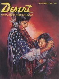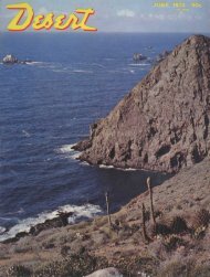
THE M A G A Z I N E - Desert Magazine of the Southwest
THE M A G A Z I N E - Desert Magazine of the Southwest
THE M A G A Z I N E - Desert Magazine of the Southwest

Create successful ePaper yourself
Turn your PDF publications into a flip-book with our unique Google optimized e-Paper software.
eached a vantage point that was excellent<br />
for photographs.<br />
The floor <strong>of</strong> <strong>the</strong> canyon was gloomy<br />
and cold when I finished with my cameras.<br />
Finding a log I sat down and watched<br />
<strong>the</strong> deep rays <strong>of</strong> <strong>the</strong> dying sun cast flaming<br />
highlights on tse gahwoots'onih. Fur<strong>the</strong>r<br />
up <strong>the</strong> canyon night was falling, and<br />
<strong>the</strong> spruce trees that perch along <strong>the</strong> rim<br />
made blue-black triangles against <strong>the</strong><br />
whiteness <strong>of</strong> <strong>the</strong> snow.<br />
Far above me I heard Elliott and Ben<br />
crashing down through <strong>the</strong> rocks and<br />
brush. When <strong>the</strong>y were near, I yelled.<br />
Soon we were toge<strong>the</strong>r hurrying out <strong>of</strong><br />
<strong>the</strong> canyon. There is little time between<br />
sunset and night under <strong>the</strong> low skies <strong>of</strong><br />
Navajoland.<br />
Night had set in when we reached <strong>the</strong><br />
car. The winter moon was a lemon-yellow<br />
ball over Shiprock pinnacle when we<br />
started <strong>of</strong>f <strong>the</strong> mesa. While we jounced<br />
•down <strong>the</strong> trail Elliott and I compared<br />
notes.<br />
The geologic formation <strong>of</strong> <strong>the</strong> redrock<br />
•country was Navajo sandstone. Tse gahwoots'onih<br />
was <strong>of</strong> <strong>the</strong> same formation.<br />
Once <strong>the</strong> arch had been a part <strong>of</strong> <strong>the</strong> main<br />
body, but after eons <strong>of</strong> wind, water, and<br />
freezing, it had been gouged, rasped, and<br />
cracked, eventually to become isolated<br />
from <strong>the</strong> canyon wall. Standing 301 feet<br />
high, we believe that it is <strong>the</strong> highest rock<br />
arch yet known in Arizona. This is only<br />
seven feet lower than <strong>the</strong> famous Rainbow<br />
bridge <strong>of</strong> Utah.<br />
Elliott and Ben had carefully searched<br />
for inscriptions. They found none. Without<br />
doubt, we were one <strong>of</strong> <strong>the</strong> few white<br />
parties to visit <strong>the</strong> arch. Recognizing its<br />
accessibility, we wondered how it could<br />
have been so long missed as one <strong>of</strong> Arizona's<br />
great natural wonders. The answer<br />
soon came.<br />
When we approached <strong>the</strong> camp <strong>of</strong><br />
Hadalth chadih bikiis, a figure stepped<br />
out <strong>of</strong> <strong>the</strong> gloom into <strong>the</strong> rays <strong>of</strong> our headlights.<br />
We stopped. When <strong>the</strong> figure came<br />
•close, we recognized <strong>the</strong> seamed face <strong>of</strong><br />
<strong>the</strong> aged Navajo leader.<br />
The old Indian looked angry. Cigarettes<br />
were tendered as a peace <strong>of</strong>fering.<br />
Then he asked Ben where we had been.<br />
Ben answered, "To <strong>the</strong> great rock <strong>of</strong> tse<br />
gahwoots'onih, grandfa<strong>the</strong>r."<br />
"You know that we don't allow white<br />
men in <strong>the</strong> canyon <strong>of</strong> <strong>the</strong> perforated rock!"<br />
snapped <strong>the</strong> old man back at Ben. "They<br />
have always hunted some precious rock<br />
in <strong>the</strong>re. Black Horse drove <strong>the</strong>m away.<br />
Some never came out!"<br />
Ben's laugh was weak as he answered<br />
<strong>the</strong> old man, "These white men did no<br />
digging, grandfa<strong>the</strong>r. They only looked<br />
at tse gahwoots'onih." Then turning to Elliott,<br />
he whispered out <strong>of</strong> <strong>the</strong> corner <strong>of</strong><br />
his mouth, "Drive on! We want no<br />
trouble with him. He is one <strong>of</strong> <strong>the</strong> last <strong>of</strong><br />
Black Horse's band. He still could be<br />
mean!"<br />
Elliott started <strong>the</strong> car. As we moved<br />
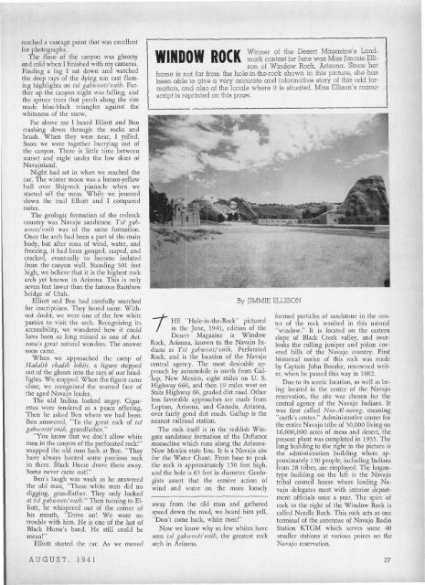
WINDOW ROCK<br />
Winner <strong>of</strong> <strong>the</strong> <strong>Desert</strong> <strong>Magazine</strong>'s Landmark<br />
contest for June was Miss Jimmie Ellison<br />
<strong>of</strong> Window Rock, Arizona. Since her<br />
home is not far from <strong>the</strong> hole-in-<strong>the</strong>-rock shown in this picture, she has<br />
been able to give a very accurate and informative story <strong>of</strong> this odd formation,<br />
and also <strong>of</strong> <strong>the</strong> locale where it is situated. Miss Ellison's manuscript<br />
is reprinted on this page.<br />
rHE "Hole-in-<strong>the</strong>-Rock" pictured<br />
in <strong>the</strong> June, 1941, edition <strong>of</strong> <strong>the</strong><br />
<strong>Desert</strong> <strong>Magazine</strong> is Window<br />
Rock, Arizona, known to <strong>the</strong> Navajo Indians<br />
as Tse gahwoots'onih, Perforated<br />
Rock, and is <strong>the</strong> location <strong>of</strong> <strong>the</strong> Navajo<br />
central agency. The most desirable approach<br />
by automobile is north from Gal-<br />
'lup, New Mexico, eight miles on U. S.<br />
Highway 666, and <strong>the</strong>n 19 miles west on<br />
State Highway 68, graded dirt road. O<strong>the</strong>r<br />
less favorable approaches are made from<br />
Lupton, Arizona, and Ganado, Arizona,<br />
over fairly good dirt roads. Gallup is <strong>the</strong><br />
nearest railroad station.<br />
The rock itself is in <strong>the</strong> reddish Wingate<br />
sandstone formation <strong>of</strong> <strong>the</strong> Defiance<br />
monocline which runs along <strong>the</strong> Arizona-<br />
New Mexico state line. It is a Navajo site<br />
for <strong>the</strong> Water Chant. From base to peak<br />
<strong>the</strong> rock is approximately 150 feet high,<br />
and <strong>the</strong> hole is 65 feet in diameter. Geologists<br />
assert that <strong>the</strong> erosive action <strong>of</strong><br />
wind and water on <strong>the</strong> more loosely<br />
By JIMMIE ELLISON<br />
away from <strong>the</strong> old man and ga<strong>the</strong>red<br />
speed down <strong>the</strong> road, we heard him yell,<br />
"Don't come back, white men!"<br />
Now we know why so few whites have<br />
seen tse gahwoots'onih, <strong>the</strong> greatest rock<br />
arch in Arizona.<br />
formed particles <strong>of</strong> sandstone in <strong>the</strong> center<br />
<strong>of</strong> <strong>the</strong> rock resulted in this natural<br />
"window." It is located on <strong>the</strong> eastern<br />
slope <strong>of</strong> Black Creek valley, and overlooks<br />
<strong>the</strong> rolling juniper and pirion covered<br />
hills <strong>of</strong> <strong>the</strong> Navajo country. First<br />
historical notice <strong>of</strong> this rock was made<br />
by Captain John Bourke, renowned writer,<br />
when he passed this way in 1882.<br />
Due to its scenic location, as well as being<br />
located in <strong>the</strong> center <strong>of</strong> <strong>the</strong> Navajo<br />
reservation, <strong>the</strong> site was chosen for <strong>the</strong><br />
central agency <strong>of</strong> <strong>the</strong> Navajo Indians. It<br />
was first called Nee-Al-neeng, meaning<br />
"earth's center." Administrative center for<br />
<strong>the</strong> entire Navajo tribe <strong>of</strong> 50,000 living on<br />
16,000,000 acres <strong>of</strong> mesa and desert, <strong>the</strong><br />
present plant was completed in 1935. The<br />
long building to <strong>the</strong> right in <strong>the</strong> picture is<br />
<strong>the</strong> administration building where approximately<br />
150 people, including Indians<br />
from 28 tribes, are employed. The hogantype<br />
building on <strong>the</strong> left is <strong>the</strong> Navajo<br />
tribal council house where leading Navajo<br />
delegates meet with interior department<br />
<strong>of</strong>ficials once a year. The spire <strong>of</strong><br />
rock to <strong>the</strong> right <strong>of</strong> <strong>the</strong> Window Rock is<br />
called Needle Rock. This rock acts as one<br />
terminal <strong>of</strong> <strong>the</strong> antennae <strong>of</strong> Navajo Radio<br />
Station KTGM which serves some 40<br />
smaller stations at various points on <strong>the</strong><br />
Navajo reservation.<br />
AUGUST, 1941 27