The Mississippi's Curious Origins
The Mississippi's Curious Origins
The Mississippi's Curious Origins

You also want an ePaper? Increase the reach of your titles
YUMPU automatically turns print PDFs into web optimized ePapers that Google loves.
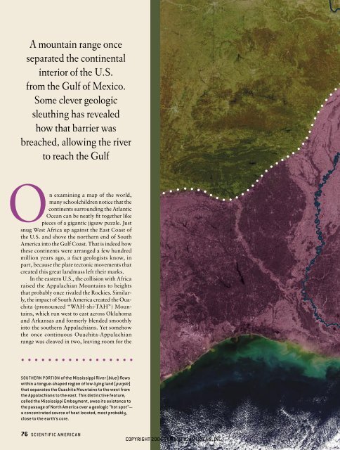
A mountain range once<br />
separated the continental<br />
interior of the U.S.<br />
from the Gulf of Mexico.<br />
Some clever geologic<br />
sleuthing has revealed<br />
how that barrier was<br />
breached, allowing the river<br />
to reach the Gulf<br />
On examining a map of the world,<br />
many schoolchildren notice that the<br />
continents surrounding the Atlantic<br />
Ocean can be neatly fit together like<br />
pieces of a gigantic jigsaw puzzle. Just<br />
snug West Africa up against the East Coast of<br />
the U.S. and shove the northern end of South<br />
America into the Gulf Coast. That is indeed how<br />
these continents were arranged a few hundred<br />
million years ago, a fact geologists know, in<br />
part, because the plate tectonic movements that<br />
created this great landmass left their marks.<br />
In the eastern U.S., the collision with Africa<br />
raised the Appalachian Mountains to heights<br />
that probably once rivaled the Rockies. Similarly,<br />
the impact of South America created the Ouachita<br />
(pronounced “WAH-shi-TAH”) Mountains,<br />
which run west to east across Oklahoma<br />
and Arkansas and formerly blended smoothly<br />
into the southern Appalachians. Yet somehow<br />
the once continuous Ouachita-Appalachian<br />
range was cleaved in two, leaving room for the<br />
SOUTHERN PORTION of the Mississippi River (blue) flows<br />
within a tongue-shaped region of low-lying land (purple)<br />
that separates the Ouachita Mountains to the west from<br />
the Appalachians to the east. This distinctive feature,<br />
called the Mississippi Embayment, owes its existence to<br />
the passage of North America over a geologic “hot spot”—<br />
a concentrated source of heat located, most probably,<br />
close to the earth’s core.<br />
76 S CIENTIFIC A MERIC A N<br />
COPYRIGHT 2006 SCIENTIFIC AMERICAN, INC.
<strong>The</strong><br />
Mississippi’s<br />
<strong>Curious</strong> <strong>Origins</strong><br />
By Roy B. Van Arsdale and Randel T. Cox<br />
COPYRIGHT 2006 SCIENTIFIC AMERICAN, INC.
<strong>The</strong> Mississippi Embayment constitutes<br />
one of the largest and least understood<br />
landforms in the central U.S.<br />
Mississippi River to flow into the Gulf<br />
of Mexico. <strong>The</strong> explanation for the split,<br />
which the two of us have been investigating<br />
for most of the past decade,<br />
touches on many other mysteries of<br />
North American geology, too—such as<br />
why you can find diamonds in Arkansas<br />
and why the largest earthquake that was<br />
ever recorded in the contiguous U.S. occurred<br />
not in California or Washington<br />
but in Missouri, of all places.<br />
<strong>The</strong> break that now separates the<br />
Ouachita Mountains from the Appalachians,<br />
a feature known as the Mississippi<br />
Embayment, constitutes one of the<br />
largest and least understood landforms<br />
of the central U.S. This huge horseshoeshaped<br />
lowland is underlain by massive<br />
quantities of sand, silt and mud deposited<br />
within a bay of the ancestral Gulf of<br />
Mexico, which first washed over this region<br />
some 85 million years ago (during<br />
the late Cretaceous, when dinosaurs still<br />
roamed the earth), and did not recede<br />
until tens of millions of years later.<br />
It is tempting to imagine that the deposits<br />
formed because Gulf waters flooded<br />
a slightly low-lying area of the continent,<br />
leaving behind a veneer of sediment<br />
when they receded. But such a conclusion<br />
would be incorrect. As geologists have<br />
known for quite a while, the base of these<br />
sediments sits as much as 2.6 kilometers<br />
below current sea level. Clearly, this part<br />
of the midcontinent must have dropped<br />
down considerably, allowing whatever<br />
river had previously drained the vast continental<br />
interior toward the north or west<br />
to turn around and flow south, thus becoming<br />
the familiar Mississippi. But why<br />
did the land there sink?<br />
<strong>The</strong> Earth Moved<br />
t h e a nsw e r to this particular geologic<br />
riddle begins with some wellunderstood<br />
events that took place while<br />
trilobites were still scurrying around and<br />
long before the Mississippi Embayment<br />
formed. Throughout most of the Paleozoic<br />
era (545 million to 245 million years<br />
ago), the region destined to become the<br />
U.S. was surrounded by ocean. But 300<br />
million years ago (about when the first<br />
reptiles evolved), the landmasses that<br />
would later turn into North America,<br />
South America, Africa and Eurasia came<br />
together to form the supercontinent that<br />
geologists call Pangaea. <strong>The</strong>se titanic<br />
collisions raised several mountain ranges,<br />
including the Ouachita-Appalachian<br />
Overview/Making Way for a River<br />
■ <strong>The</strong> Ouachita Mountains of Arkansas and Oklahoma once connected with the<br />
southern end of the Appalachians, forming a continuous range that forced<br />
rivers draining the continental interior to flow north or west into the sea.<br />
■ Passage of North America over a temporarily reinvigorated mantle hot spot<br />
caused uplift of a section of this mountain range just north of the Gulf of<br />
Mexico in the mid-Cretaceous, forming an arch. Weathering soon eroded<br />
the newly formed highlands, reducing them to the level of adjacent lands.<br />
■ As this region moved away from the hot spot, the land subsided, allowing<br />
the ocean to flood a large tongue-shaped area into which rivers draining the<br />
continent could then flow. <strong>The</strong> modern Mississippi continues to meander<br />
south through sediments that fill this depression.<br />
■ Passage of North America over mantle hot spots also accounts for the<br />
earthquakes that have struck some areas of the midcontinent.<br />
chain. For the next 70 million years or<br />
so, this east-west-trending mountain<br />
range divided the interior of one vast<br />
continent. Rivers that began as tiny<br />
streams in these mountains flowed either<br />
to the south, onto the future South American<br />
continent, or to the north, onto what<br />
would become North America.<br />
About 230 million years ago (which<br />
happens to be when the first dinosaurs<br />
appeared), Pangaea started to break up.<br />
Not surprisingly, it ripped apart where<br />
it had previously been sutured together:<br />
just outside the arc of the Ouachita-<br />
Appalachian mountains. This opening<br />
formed both the Atlantic Ocean and the<br />
Gulf of Mexico. <strong>The</strong> Atlantic is still expanding<br />
today, but the Gulf continued<br />
to widen only until about 145 million<br />
years ago (about when the first birds<br />
evolved).<br />
For tens of millions of years, the<br />
Ouachita-Appalachian mountains stood<br />
as a continuous range along the northern<br />
border of the Gulf of Mexico. While<br />
such a barrier was in place, the continental<br />
interior could not have drained southward<br />
into the Gulf. <strong>The</strong> geology of the<br />
Gulf of Mexico indicates as much. Over<br />
this lengthy interval, the northern fringes<br />
of the Gulf hosted a bank of coral<br />
reefs, which later became the thick petroleum-bearing<br />
limestone deposits that<br />
geologists have traced in the subsurface<br />
all the way from Florida to northern<br />
Mexico. Corals cannot tolerate being<br />
smothered by silt and clay; hence, a major<br />
river such as the Mississippi could<br />
not have been dumping sediment into<br />
the northern Gulf during that era.<br />
For this great breadth of time, the<br />
Gulf Coast remained geologically stable,<br />
with no continents plowing into it<br />
or rifting away. But the calm was broken<br />
about 95 million years ago: beginning<br />
then, and continuing for the next 10<br />
million years, the crust warped upward<br />
over a large area, from southern Louisiana<br />
north into southeastern Missouri<br />
and from the present-day Tennessee<br />
River west to Little Rock, Ark.—the<br />
footprint of what is now the Mississippi<br />
Embayment.<br />
<strong>The</strong> result was a broad, northeasttrending<br />
arch, which rose to an impos-<br />
78 S CIENTIFIC A MERIC A N JANU A RY 2007<br />
COPYRIGHT 2006 SCIENTIFIC AMERICAN, INC.<br />
N A S A / T HE V I S IBL E E A R T H (base satellite image) ( preceding pages) ; C HR I S T OP HER R . S C O T E S E PALEOMAP Pr ojec t<br />
( paleogeographic globes for Triassic, early Cr etaceous and late Cr etaceous) (opposite page)
Gulf of<br />
Mexico<br />
200 million<br />
years ago<br />
Ouachita-<br />
Appalachian<br />
Mountains<br />
140 million<br />
years ago<br />
80 million<br />
years ago<br />
Ouachita<br />
Mountains<br />
Atlantic Basin<br />
Appalachian<br />
Mountains<br />
Snapshots<br />
from the Past<br />
Plate tectonic reconstructions<br />
show the evolution of the<br />
mountainous barrier that long<br />
prevented the rivers draining<br />
the interior of North America<br />
from flowing south to the sea,<br />
as the Mississippi does today.<br />
About 200 million years ago<br />
(top) the continents of the<br />
world abutted one another,<br />
forming a giant supercontinent,<br />
which geologists<br />
call Pangaea. <strong>The</strong> collisions<br />
that brought the continents<br />
into this configuration raised<br />
various mountain ranges,<br />
including what was then a<br />
continuous line of mountains<br />
that ran along the southern<br />
and eastern flanks of the<br />
North American plate. Rivers<br />
draining the interior of<br />
North America could not have<br />
crossed this formidable<br />
barrier and thus must have<br />
flowed northward or westward<br />
into the sea.<br />
<strong>The</strong> Ouachita-Appalachian<br />
mountains remained a continuous<br />
barrier even after the<br />
Yucatán block shifted<br />
southward and the African<br />
plate separated from North<br />
America, plate tectonic motions<br />
that by the early Cretaceous<br />
(about 140 million years ago)<br />
created, respectively, the Gulf<br />
of Mexico and much of the<br />
modern Atlantic Basin (middle).<br />
By the late Cretaceous<br />
(some 80 million years ago),<br />
a large depression divided this<br />
mountain range north of the<br />
Gulf of Mexico, forming a huge<br />
bay. This was a time of globally<br />
high sea level, when the ocean<br />
flooded low-lying continental<br />
areas all over the world<br />
(bottom).<br />
—R.B.V.A. and R.T.C.<br />
ing altitude, perhaps two or three kilometers<br />
above sea level. (In comparison,<br />
the Himalayan Plateau currently stands<br />
about five kilometers high.) Evidence<br />
that such a vast uplifted region once<br />
existed over the Mississippi Embayment<br />
is indirect—but quite solid. For example,<br />
geologists have found telltale gravels<br />
at various sites to the east. Detailed<br />
studies of these deposits indicate that<br />
energetic streams flowed at this time<br />
out of the newly created highlands, carrying<br />
gravel with them as they cascaded<br />
eastward.<br />
Even more compelling proof of widespread<br />
uplift comes from what is not<br />
found in the Mississippi Embayment: up<br />
to three kilometers of rock formed before<br />
the late Cretaceous. That pile of<br />
rock is conspicuously missing along the<br />
axis of the embayment. We would expect<br />
the missing strata to have been<br />
eroded away if they were raised far above<br />
sea level during this 10-million-year period—high-standing<br />
terrain being especially<br />
susceptible to the ever present influence<br />
of weathering, which over geologic<br />
time tends to grind even great<br />
mountains down to near nothingness.<br />
<strong>The</strong> next major event was the subsidence<br />
of the embayment, which geologists<br />
have determined must have taken<br />
place from 85 million to 24 million<br />
years ago. During this interval, the area<br />
that had previously been lifted two to<br />
three kilometers into the air headed in<br />
the other direction, dropping below sea<br />
level by about the same amount. Thus,<br />
what had formerly been the crest of a<br />
high, arched mountain range became<br />
inundated with seawater and was eventually<br />
buried by as much as 2.6 kilometers<br />
of marine sediment.<br />
Hot-Spot Roller Coaster<br />
w h at process could have raised an<br />
immense area of the planet’s crust and<br />
then caused it to start sinking, all within<br />
a geologically short period? <strong>The</strong> answer<br />
that the two of us have slowly put together<br />
is that the Mississippi Embayment<br />
passed over a mantle hot spot—a<br />
deep-seated source of exceptionally<br />
great heat situated, most likely, near the<br />
base of the earth’s mantle (the thick zone<br />
w w w.sciam.com S CIENTIFIC A MERIC A N 79<br />
COPYRIGHT 2006 SCIENTIFIC AMERICAN, INC.
HOW TO DIVIDE A MOUNTAIN RANGE<br />
<strong>The</strong> once continuous Ouachita-Appalachian range was cleaved in two by the Mississippi Embayment, created after this area of the continent<br />
Ouachita-<br />
Appalachian<br />
range<br />
North American<br />
plate motion<br />
Bermuda<br />
hot-spot<br />
conduit<br />
North<br />
Water flow<br />
Magma<br />
by the Bermuda hot spot was located west of the Mississippi<br />
Valley graben, a zone containing ancient, steeply inclined faults.<br />
<strong>The</strong> presence of the high-standing Ouachita-Appalachian range<br />
forced the rivers that drained the interior of the continent to flow<br />
north or west to the sea.<br />
within the earth between the crust and<br />
the core). Above such heat sources, hot<br />
rock rises through nearly 3,000 kilometers<br />
of mantle and crust before reaching<br />
the surface.<br />
When a plate passes over such a deep<br />
source of heat, the motion often creates<br />
a distinctive line of volcanoes on the surface<br />
(for example, the Hawaiian Island<br />
chain). <strong>The</strong>y can be arrayed one after the<br />
other, or they can blend together into<br />
one continuous ridge. <strong>The</strong>se hot-spotinduced<br />
volcanic features can be likened<br />
to the line of burn marks you might see<br />
if you moved a plate of steel horizontally<br />
above a stationary welder’s torch.<br />
We began to think that a hot spot<br />
Mississippi Valley graben<br />
Plume head<br />
was involved when we reviewed plate<br />
motion models for North America. <strong>The</strong>y<br />
revealed that the central and eastern<br />
U.S. moved over the Bermuda hot spot<br />
(so named because it later created the<br />
volcanic edifice that underlies Bermuda).<br />
This motion occurred during the<br />
very time that the area of the Mississippi<br />
Embayment was rising upward.<br />
Such passage would neatly explain the<br />
uplift, because the hot, rising magma<br />
engendered by the Bermuda hot spot<br />
would have buoyed the crust and caused<br />
it to expand thermally.<br />
Direct evidence for this phenomenon<br />
includes some rather special volcanic<br />
features called kimberlite pipes, in which<br />
ROY B. VAN ARSDALE and RANDEL T. COX share a keen interest in the causes of earthquakes<br />
that occur in the interiors of tectonic plates. Van Arsdale earned a Ph.D. in geology from<br />
the University of Utah in 1979 and is now a professor at the University of Memphis. He<br />
has studied the geology of the New Madrid seismic zone in particular for the past 15 years.<br />
Cox received a doctorate from the University of Missouri–Columbia in 1995 and is currently<br />
a professor at Memphis. His research interests include the evolution of the Mississippi<br />
Valley and surrounding regions, documentation of prehistoric earthquakes in the<br />
central U.S. and Central America, and the geologic effects of volcanic hot spots.<br />
T H E A U T H O R S 1 In the early Cretaceous, the plume of hot, rising rock engendered<br />
Uplift of Mississippi<br />
Embayment arch<br />
Plate tectonic motion brought the Mississippi Valley graben over the<br />
2 Bermuda hot spot in the mid-Cretaceous, when the activity of such<br />
deep-seated heat sources was heightened worldwide. Magma flowed up<br />
along the faults, inflating this region with added material, while<br />
simultaneously causing the upper part of the plate here to expand thermally.<br />
<strong>The</strong> result was a broad zone of uplift—the Mississippi Embayment arch.<br />
a few fortunate people have found diamonds.<br />
(Those wishing to try their luck<br />
should head for Crater of Diamonds<br />
State Park near Hot Springs, Ark.) Indeed,<br />
igneous rocks, the kind formed by<br />
the cooling of magma, can be found intermittently<br />
at many points that once<br />
passed over the Bermuda hot spot. <strong>The</strong>se<br />
igneous rocks stretch from central Kansas,<br />
where they are 115 million years<br />
old, to central Mississippi, where they<br />
are 70 million years old—an age progression<br />
that fits well with the east-towest<br />
motion of North America over the<br />
hot spot.<br />
Having come to this realization, we<br />
saw clearly what had caused the Mississippi<br />
Embayment not only to rise but<br />
also to fall back down later. <strong>The</strong> uplift<br />
created a high arch whose crest extended<br />
along a line that approximately follows<br />
where the Mississippi River is today. But<br />
within 10 million years, weathering<br />
caused those highlands to erode down to<br />
sea level or thereabouts. <strong>The</strong>n, as the<br />
Mississippi Embayment drifted off the<br />
80 S CIENTIFIC A MERIC A N JANU A RY 2007<br />
COPYRIGHT 2006 SCIENTIFIC AMERICAN, INC.<br />
Magma<br />
JEN C HR I S T I A N S EN
passed over a mantle hot spot. <strong>The</strong> four panels illustrate the mechanism by which the embayment formed.<br />
Erosion of<br />
uplifted region<br />
Truncated<br />
pluton<br />
<strong>The</strong> ever present forces of weathering soon eroded the newly uplifted<br />
3 terrain. This lowering of what had been a high-standing, mountainous<br />
arch truncated the tops of some igneous “plutons.” <strong>The</strong>se bodies of<br />
crystalline rock were formed earlier by magma that rose from great<br />
depths but cooled and solidified before reaching the surface. <strong>The</strong>ir<br />
truncation is one sign that erosion occurred.<br />
Bermuda hot spot, the crust there cooled,<br />
contracted and subsided to a maximum<br />
depth of 2.6 kilometers below sea level.<br />
It might seem surprising that the land<br />
sank so low. But remember that the area<br />
was raised to a height somewhere between<br />
two and three kilometers above<br />
sea level and then erosionally beveled<br />
off. So after the crust cooled and subsided,<br />
it did not return to its original<br />
configuration because it was missing between<br />
two and three kilometers’ worth<br />
of rock at the top. Hence, a trough<br />
formed and was inundated with water<br />
from the Gulf of Mexico.<br />
A closer look at the Arkansas diamond-bearing<br />
rocks supports our notion<br />
of how the crust lifted upward and<br />
then sank. <strong>The</strong> character of the rocks<br />
that gave rise to those diamonds implies<br />
that their parent magmas rose from the<br />
mantle to shallow depths in the crust,<br />
about a kilometer or so below the surface,<br />
where they solidified. Yet geologic<br />
investigations reveal that along the axis<br />
of the embayment many of these great<br />
Subsidence of eroded<br />
landscape (Mississippi<br />
Embayment)<br />
In the late Cretaceous, after the Mississippi Valley graben moved<br />
4 away from the Bermuda hot spot, the region that had been uplifted<br />
cooled and subsided, allowing the sea, which stood relatively high at the<br />
time, to flood the area. Rivers draining the continental interior, including<br />
the ancestral Mississippi, could now flow southward, into the new<br />
embayment, which gradually filled with sediment.<br />
masses of rock were deeply eroded at<br />
their tops and later buried under late<br />
Cretaceous deposits—just what you<br />
would expect to see if uplift and erosion<br />
accompanied the injection of magma before<br />
the crust subsided below sea level,<br />
allowing the ocean to flow in and cover<br />
everything with marine sediments.<br />
Flies in the Ointment?<br />
t wo fe at u r es of our scenario may<br />
seem problematic at first blush. <strong>The</strong> first<br />
is that the crest of the arch that once occupied<br />
the embayment ran from southwest<br />
to northeast, at nearly right angles<br />
to the trace of the Bermuda hot spot, the<br />
line marking places that at one time sat<br />
directly above this long-lasting heat<br />
source. If you accept that the hot spot<br />
caused the arch to form, you might well<br />
wonder why this trace is not aligned<br />
with the crest.<br />
This incongruity is not as troubling<br />
as it might seem. On the floor of the Atlantic<br />
Ocean near the current location of<br />
the Bermuda hot spot is the Bermuda<br />
rise, a northeast-trending feature where<br />
the seafloor is arched upward. And it,<br />
too, is essentially perpendicular to the<br />
trace of the hot spot. <strong>The</strong> standard explanation<br />
for the orientation of the rise<br />
hinges on the observation that the seafloor<br />
in this area has a steeply inclined<br />
set of faults that trend northeast to<br />
southwest and cut through the entire<br />
crust. <strong>The</strong> upwelling of magma that<br />
<strong>The</strong> crust subsided below sea level,<br />
allowing the ocean to flow in and cover<br />
everything with marine sediments.<br />
w w w.sciam.com S CIENTIFIC A MERIC A N 81<br />
COPYRIGHT 2006 SCIENTIFIC AMERICAN, INC.<br />
Sea<br />
Ancestral<br />
Mississippi River
Hot-Spot Signatures<br />
<strong>The</strong> motion of North America over the Bermuda hot spot and<br />
over a second one—the Great Meteor hot spot—is illustrated<br />
by a plot of the hot spots’ “tracks,” lines delineating locations<br />
on the surface that have passed over these deep-seated<br />
sources of heat (orange lines). <strong>The</strong>se hot spots affected the<br />
North American plate in various ways. <strong>The</strong> elongation of the<br />
embayment to the northeast results from the channeling<br />
of hot-spot-derived magma along preexisting faults (yellow<br />
lines in embayment region)—as does the northeast-<br />
Central<br />
North American<br />
rift system<br />
Mississippi<br />
Valley<br />
rift system<br />
Ouachita<br />
Mountains<br />
built the rise was presumably channeled<br />
along these lines of weakness, raising the<br />
seafloor in places that are relatively far<br />
from the hot spot. If this conclusion is<br />
correct, the first difficulty with our theory<br />
disappears, because ancient northeast-trending<br />
rift faults can also be found<br />
under the Mississippi Embayment.<br />
<strong>The</strong>se fractures in the crust could have<br />
similarly channeled magma engendered<br />
by the Bermuda hot spot, creating an uplifted<br />
landscape that was elongated from<br />
southwest to northeast.<br />
<strong>The</strong> second potential fly in the ointment<br />
is the obvious question of why the<br />
Bermuda hot spot had such a profound<br />
Boundary of<br />
the Mississippi<br />
Embayment<br />
New Madrid, Mo.<br />
A p p a l a c h i a n M o u n t a i n s<br />
effect in the area of the Mississippi Embayment,<br />
given that it left so little signature<br />
elsewhere on the North American<br />
continent. But we think we have an explanation<br />
for this observation as well,<br />
one that revolves around the fact that the<br />
Bermuda hot spot was underneath the<br />
Mississippi Embayment precisely during<br />
a period in the earth’s history when hot<br />
spots were pouring out enormous volumes<br />
of magma all over the world. Geologists<br />
call this interval of enhanced<br />
magmatism and heat production a “superplume”<br />
event [see “<strong>The</strong> Mid-Cretaceous<br />
Superplume Episode,” by Roger L.<br />
Larson; Scientific American, Febru-<br />
southwest elongation of the Bermuda rise on the ocean floor.<br />
<strong>The</strong> New England seamounts are a product of the plate’s travel<br />
over the Great Meteor hot spot. And passage of North America<br />
over these two hot spots reactivated ancient faults in the<br />
central North American, Mississippi Valley and St. Lawrence<br />
rift systems, accounting for the earthquakes that have taken<br />
place near the southern end of the central North American rift<br />
system, in New Madrid, Mo., in Charleston, S.C., and around the<br />
St. Lawrence River in Canada. —R.B.V.A. and R.T.C.<br />
Charleston, S.C.<br />
St. Lawrence<br />
rift system<br />
Atlantic<br />
Ocean<br />
Bermuda hot-spot track<br />
Bermuda<br />
Great Meteor hot-spot track<br />
New England seamounts<br />
Bermuda rise<br />
Bermuda<br />
hot spot<br />
ary 1995]. (Among other manifestations<br />
of this distinctive occurrence, many diamond-bearing<br />
kimberlite pipes formed.)<br />
Thus, the solution to this second concern<br />
may be that the faulted crust of the<br />
Mississippi Embayment just happened<br />
to be in the right place at the right time,<br />
when the usually docile Bermuda hot<br />
spot kicked into high gear.<br />
So it seems that the passage of the<br />
North American tectonic plate over the<br />
temporarily reinvigorated Bermuda hot<br />
spot accounts for how a part of the crust<br />
that was once covered by mountains<br />
could be turned into a trough. This<br />
change was sufficient to reverse the<br />
82 S CIENTIFIC A MERIC A N JANU A RY 2007<br />
COPYRIGHT 2006 SCIENTIFIC AMERICAN, INC.<br />
JEN C HR I S T I A N S E N
On February 7, 1812, the largest earthquake<br />
ever recorded in the contiguous U.S.<br />
struck the town of New Madrid, Mo.<br />
drainage of the continental interior,<br />
sending water that once must have<br />
flowed far to the north or west instead<br />
to the Gulf of Mexico.<br />
Whole Lot of Shakin’ Going On<br />
f u rt h e r su pport for our model<br />
comes from a geologic event of much<br />
younger vintage—it took place less than<br />
two centuries ago. On February 7, 1812,<br />
the largest earthquake ever recorded in<br />
the contiguous U.S. struck the town of<br />
New Madrid, Mo. <strong>The</strong> temblor, which<br />
seismologists estimate would have measured<br />
8.0 on the Richter scale, was even<br />
powerful enough to change the course of<br />
the Mississippi in one spot.<br />
It might appear strange that such a<br />
calamity should strike the typically quiet<br />
center of the continent, far from all the<br />
grinding and slipping that goes on at<br />
plate boundaries, where earthquakes are<br />
relatively common. Yet such interior<br />
quakes can occur in places that contain<br />
old, faulted crust, and New Madrid sits<br />
above an ancient fractured structure<br />
called the Mississippi Valley (or “Reelfoot”)<br />
rift system. Most areas with ancient<br />
faults do not experience earthquakes.<br />
Indeed, the entire East Coast is<br />
underlain by rifted crust but is largely<br />
without earthquakes.<br />
A hint to what makes the rifted crust<br />
below the Mississippi Embayment prone<br />
to earthquakes comes from Charleston,<br />
S.C., which is also a seismic zone (the big<br />
one having struck there in 1886). Like<br />
New Madrid, Charleston lies over ancient<br />
rifted crust. What the New Madrid<br />
and Charleston seismic zones also have<br />
in common is that they once passed over<br />
the Bermuda hot spot. To the west, the<br />
anomalously seismic southern end of the<br />
central North American rift system near<br />
Manhattan, Kan., lies close to the trace<br />
of the Bermuda hot spot as well. <strong>The</strong><br />
trace of a hot spot also coincides with<br />
the most seismically active area in eastern<br />
Canada, the St. Lawrence rift: during<br />
the Cretaceous period, this part of<br />
Canada passed over the Great Meteor<br />
hot spot, named for the Great Meteor<br />
seamount in the Atlantic Ocean, where<br />
subsea volcanism has taken place during<br />
geologically recent times.<br />
It thus appears that passage of a tectonic<br />
plate over a hot spot can reactivate<br />
ancient faults, causing slippage to occur<br />
on them from time to time, even many<br />
millions of years later, presumably because<br />
the crust takes a long while to set-<br />
tle down after being heated and uplifted.<br />
So the picture we have put together not<br />
only accounts for creation of the Mississippi<br />
Embayment—it also explains why<br />
significant seismicity occurs in parts of<br />
eastern North America far from the<br />
boundaries of tectonic plates.<br />
That such different things as earthquakes<br />
in Canada and diamonds in Arkansas<br />
fit well with our explanation for<br />
the formation of the Mississippi Embayment<br />
gives us confidence in the validity<br />
of our ideas. And it is quite interesting to<br />
think that the course of the mighty Mississippi<br />
was fundamentally controlled<br />
by goings-on a full 2,900 kilometers<br />
away—and straight downward, at the<br />
boundary between the earth’s core and<br />
mantle. This surprising conclusion provides<br />
a close-to-home reminder of the<br />
connectedness of the different parts of<br />
our fascinating planet.<br />
EARTHQUAKE rocked Charleston, S.C., in 1886. <strong>The</strong> cause was slippage along ancient faults, a<br />
delayed response to the passage of the area over the Bermuda hot spot some 60 million years ago.<br />
M O R E T O E X P L O R E<br />
A Major Earthquake Zone on the Mississippi. Arch C. Johnston in Scientific American, Vol. 246,<br />
No. 4, pages 60–68; April 1982.<br />
Latest Pulse of Earth: Evidence for a Mid-Cretaceous Super Plume. Roger L. Larson in<br />
Geology, Vol. 19, pages 547–550; 1991.<br />
Hotspot Origin of the Mississippi Embayment and Its Possible Impact on Contemporary<br />
Seismicity. Randel T. Cox and Roy B. Van Arsdale in Engineering Geology, Vol. 46,<br />
pages 201–216; 1997.<br />
<strong>The</strong> Mississippi Embayment, North America: A First Order Continental Structure Generated<br />
by the Cretaceous Superplume Mantle Event. Randel T. Cox and Roy B. Van Arsdale in<br />
Journal of Geodynamics, Vol. 34, pages 163–176; 2002.<br />
82B S CIENTIFIC A MERIC A N JANU A RY 2007<br />
COPYRIGHT 2006 SCIENTIFIC AMERICAN, INC.<br />
J. B. M A C E LWA NE A R C HI V E S , S T. L O UIS UNI V E R S I T Y, A ND S O U T H C A R OL INI A N A L IBR A R Y, UNI V E R S I T Y OF S O U T H C A R OL IN A