Admiralty Charts affected by the Publication List Admiralty Chart 120 ...
Admiralty Charts affected by the Publication List Admiralty Chart 120 ...
Admiralty Charts affected by the Publication List Admiralty Chart 120 ...

You also want an ePaper? Increase the reach of your titles
YUMPU automatically turns print PDFs into web optimized ePapers that Google loves.
I<br />
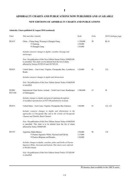
ADMIRALTY CHARTS AND PUBLICATIONS NOW PUBLISHED AND AVAILABLE<br />
NEW EDITIONS OF ADMIRALTY CHARTS AND PUBLICATIONS<br />
<strong>Admiralty</strong> <strong><strong>Chart</strong>s</strong> published 26 August 2010 (continued)<br />
<strong>Chart</strong> Title and o<strong>the</strong>r remarks Scale Folio 2010 Catalogue page<br />
1619 China – Chang Jiang, Wusong to Zhangjia Gang.<br />
A Nantong.<br />
B Zhangjia Gang.<br />
Includes extensive changes to depths, coastline, buoyage and<br />
anchorages.<br />
Note: On publication of this New Edition former Notice 2499(P)/09<br />
is cancelled. This chart is to be deleted from <strong>the</strong> list of charts<br />
<strong>affected</strong> <strong>by</strong> Notices 937(P)/10 and 3017(P)/10.<br />
2829 United States – East Coast, Virginia, Chesapeake Bay, Lynnhaven<br />
Roads.<br />
2900<br />
INT1100<br />
Includes extensive changes to depths and obstructions.<br />
Note: On publication of this New Edition former Notice 4106(P)/09<br />
is cancelled.<br />
International <strong>Chart</strong> Series, Iceland – North East Coast, Rauđinúpur<br />
to Glettinganes.<br />
Includes changes to depths and general updating throughout.<br />
(A modified reproduction of INT1100 published <strong>by</strong> Iceland).<br />
2919 United States – East Coast, Virginia, Chesapeake Bay Entrance.<br />
Includes extensive changes to depths and obstructions in <strong>the</strong><br />
approaches to Chesapeake Bay and in <strong>the</strong> vicinity of Chesapeake<br />
Channel and Thimble Shoal Channel.<br />
Note: On publication of this New Edition former Notice 4106(P)/09<br />
is cancelled. This chart is to be deleted from <strong>the</strong> list of charts<br />
<strong>affected</strong> <strong>by</strong> Notice 5840(P)/09.<br />
3755 Argentina, Bahía Blanca.<br />
A Puertos Ingeniero White, Nacional and Galván.<br />
B Puertos Belgrano and Rosales.<br />
Includes changes to depths, coastline, jetties and berths at Puertos<br />
Ingeniero White, Nacional and Galván. This chart is now referred<br />
to WGS84 Datum.<br />
Note: On publication of this New Edition former Notice 5213(P)/09<br />
is cancelled.<br />
1.9<br />
1:130,000<br />
1:30,000<br />
1:35,000<br />
50 80, 81<br />
1:20,000 81 132<br />
1:300,000 15 28<br />
1:80,000 81 122, 132<br />
1:50,000<br />
1:15,000<br />
1:20,000<br />
96 118<br />
denotes chart available in <strong>the</strong> ARCS series.