Admiralty Charts affected by the Publication List Admiralty Chart 120 ...
Admiralty Charts affected by the Publication List Admiralty Chart 120 ...
Admiralty Charts affected by the Publication List Admiralty Chart 120 ...
You also want an ePaper? Increase the reach of your titles
YUMPU automatically turns print PDFs into web optimized ePapers that Google loves.
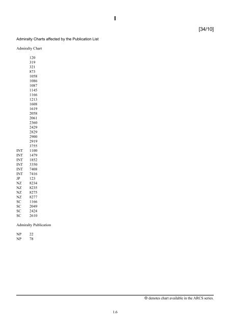
<strong>Admiralty</strong> <strong><strong>Chart</strong>s</strong> <strong>affected</strong> <strong>by</strong> <strong>the</strong> <strong>Publication</strong> <strong>List</strong><br />
<strong>Admiralty</strong> <strong>Chart</strong><br />
<strong>120</strong><br />
319<br />
321<br />
873<br />
1058<br />
1086<br />
1087<br />
1145<br />
1166<br />
1213<br />
1608<br />
1619<br />
2058<br />
2061<br />
2360<br />
2429<br />
2829<br />
2900<br />
2919<br />
3755<br />
INT 1100<br />
INT 1479<br />
INT 1852<br />
INT 3350<br />
INT 7408<br />
INT 7416<br />
JP 123<br />
NZ 8234<br />
NZ 8235<br />
NZ 8275<br />
NZ 8277<br />
SC 1166<br />
SC 2049<br />
SC 2424<br />
SC 2610<br />
<strong>Admiralty</strong> <strong>Publication</strong><br />
NP 22<br />
NP 78<br />
I<br />
1.6<br />
[34/10]<br />
denotes chart available in <strong>the</strong> ARCS series.
I<br />
ADMIRALTY CHARTS AND PUBLICATIONS NOW PUBLISHED AND AVAILABLE<br />
<strong>Admiralty</strong> <strong><strong>Chart</strong>s</strong> published 26 August 2010<br />
NEW ADMIRALTY CHARTS AND PUBLICATIONS<br />
<strong>Chart</strong> Title, limits and o<strong>the</strong>r remarks Scale Folio 2010 Catalogue page<br />
319<br />
INT7408<br />
321<br />
INT7416<br />
International <strong>Chart</strong> Series, India – East Coast, Sacramento Shoal to<br />
Kalingapatnam.<br />
16°34′⋅00N. — 18°19′⋅50N., 82°12′⋅00E. — 85°04′⋅00E.<br />
A replacement of <strong>Chart</strong> 2061 and one of a new series of charts<br />
providing improved coverage of <strong>the</strong> East coast of India.<br />
(A modified reproduction of INT7408 published <strong>by</strong> India).<br />
This chart is referred to WGS84 Datum.<br />
Note: <strong>Chart</strong> 2061 is to be deleted from Notices 3247(T)/09,<br />
178(P)/10 and 3536(T)/10.<br />
International <strong>Chart</strong> Series, India – East Coast, Gopālpur to Pārādip.<br />
19°07′⋅00N. — 20°48′⋅00N., 84°54′⋅00E. — 87°47′⋅00E.<br />
A replacement of <strong>Chart</strong> 2058 and one of a new series of charts<br />
providing improved coverage of <strong>the</strong> East coast of India.<br />
(A modified reproduction of INT7416 published <strong>by</strong> India).<br />
This chart is referred to WGS84 Datum.<br />
Note: <strong>Chart</strong> 2058 is to be deleted from Notice 4850(P)/05.<br />
1.7<br />
1:300,000 43 64<br />
1:300,000 43 64<br />
denotes chart available in <strong>the</strong> ARCS series.
I<br />
ADMIRALTY CHARTS AND PUBLICATIONS NOW PUBLISHED AND AVAILABLE<br />
<strong>Admiralty</strong> <strong><strong>Chart</strong>s</strong> published 26 August 2010<br />
NEW EDITIONS OF ADMIRALTY CHARTS AND PUBLICATIONS<br />
<strong>Chart</strong> Title and o<strong>the</strong>r remarks Scale Folio 2010 Catalogue page<br />
<strong>120</strong><br />
INT1479<br />
1145<br />
INT1852<br />
International <strong>Chart</strong> Series, Ne<strong>the</strong>rlands and Belgium, Westerschelde<br />
Vlissingen to Baalhoek and Gent – Terneuzen Canal.<br />
A Breskens.<br />
B Braakmanhaven.<br />
C Terneuzen Anchorage.<br />
D Continuation to Gent.<br />
E Gent.<br />
F Approaches to Terneuzen.<br />
G Vlissingen Oost (Sloehaven).<br />
H Terneuzen.<br />
I Vlissingen.<br />
Includes changes to depths and buoyage throughout.<br />
Note: This chart remains <strong>affected</strong> <strong>by</strong> Notices 6193(T)/09 and<br />
3923(T)/10.<br />
International <strong>Chart</strong> Series, Spain – North Coast, Santander.<br />
Includes harbour developments, changes to depths and <strong>the</strong><br />
maintained channel. (A modified reproduction of INT1852<br />
published <strong>by</strong> Spain).<br />
1166 England – West Coast, River Severn - Avonmouth to Sharpness and<br />
Hock Cliff.<br />
A Avonmouth to Severn Bridge.<br />
B Severn Bridge to Sharpness.<br />
C Sharpness to Hock Cliff.<br />
D Sharpness Docks.<br />
1213<br />
INT3350<br />
Includes depth information from <strong>the</strong> latest Bristol Port Company<br />
surveys. Fully modernised and updated throughout.<br />
International <strong>Chart</strong> Series, Mediterranean Sea, Bonifacio Strait.<br />
Golfo di Arzachena.<br />
The horizontal datum of this chart has been transferred to WGS84<br />
Datum. (A modified reproduction of INT3350 published <strong>by</strong> France).<br />
1.8<br />
1:40,000<br />
1:20,000<br />
1:25,000<br />
1:20,000<br />
1:40,000<br />
1:25,000<br />
1:25,000<br />
1:25,000<br />
1:25,000<br />
1:25,000<br />
9 24<br />
1:15,000 17 40<br />
1:25,000<br />
1:25,000<br />
1:25,000<br />
1:10,000<br />
1:50,000<br />
1:50,000<br />
2 20<br />
25 42<br />
denotes chart available in <strong>the</strong> ARCS series.
I<br />
ADMIRALTY CHARTS AND PUBLICATIONS NOW PUBLISHED AND AVAILABLE<br />
NEW EDITIONS OF ADMIRALTY CHARTS AND PUBLICATIONS<br />
<strong>Admiralty</strong> <strong><strong>Chart</strong>s</strong> published 26 August 2010 (continued)<br />
<strong>Chart</strong> Title and o<strong>the</strong>r remarks Scale Folio 2010 Catalogue page<br />
1619 China – Chang Jiang, Wusong to Zhangjia Gang.<br />
A Nantong.<br />
B Zhangjia Gang.<br />
Includes extensive changes to depths, coastline, buoyage and<br />
anchorages.<br />
Note: On publication of this New Edition former Notice 2499(P)/09<br />
is cancelled. This chart is to be deleted from <strong>the</strong> list of charts<br />
<strong>affected</strong> <strong>by</strong> Notices 937(P)/10 and 3017(P)/10.<br />
2829 United States – East Coast, Virginia, Chesapeake Bay, Lynnhaven<br />
Roads.<br />
2900<br />
INT1100<br />
Includes extensive changes to depths and obstructions.<br />
Note: On publication of this New Edition former Notice 4106(P)/09<br />
is cancelled.<br />
International <strong>Chart</strong> Series, Iceland – North East Coast, Rauđinúpur<br />
to Glettinganes.<br />
Includes changes to depths and general updating throughout.<br />
(A modified reproduction of INT1100 published <strong>by</strong> Iceland).<br />
2919 United States – East Coast, Virginia, Chesapeake Bay Entrance.<br />
Includes extensive changes to depths and obstructions in <strong>the</strong><br />
approaches to Chesapeake Bay and in <strong>the</strong> vicinity of Chesapeake<br />
Channel and Thimble Shoal Channel.<br />
Note: On publication of this New Edition former Notice 4106(P)/09<br />
is cancelled. This chart is to be deleted from <strong>the</strong> list of charts<br />
<strong>affected</strong> <strong>by</strong> Notice 5840(P)/09.<br />
3755 Argentina, Bahía Blanca.<br />
A Puertos Ingeniero White, Nacional and Galván.<br />
B Puertos Belgrano and Rosales.<br />
Includes changes to depths, coastline, jetties and berths at Puertos<br />
Ingeniero White, Nacional and Galván. This chart is now referred<br />
to WGS84 Datum.<br />
Note: On publication of this New Edition former Notice 5213(P)/09<br />
is cancelled.<br />
1.9<br />
1:130,000<br />
1:30,000<br />
1:35,000<br />
50 80, 81<br />
1:20,000 81 132<br />
1:300,000 15 28<br />
1:80,000 81 122, 132<br />
1:50,000<br />
1:15,000<br />
1:20,000<br />
96 118<br />
denotes chart available in <strong>the</strong> ARCS series.
I<br />
ADMIRALTY CHARTS AND PUBLICATIONS NOW PUBLISHED AND AVAILABLE<br />
NEW EDITIONS OF ADMIRALTY CHARTS AND PUBLICATIONS<br />
Reproductions of New Zealand Government <strong><strong>Chart</strong>s</strong><br />
(<strong>Publication</strong> dates of <strong>the</strong>se charts reflect <strong>the</strong> dates shown on <strong>the</strong> NZ Government <strong><strong>Chart</strong>s</strong>)<br />
<strong>Chart</strong> Published Title and o<strong>the</strong>r remarks Scale Folio 2010 Catalogue page<br />
NZ8275 April<br />
2010<br />
<strong>Admiralty</strong> <strong>Publication</strong>s<br />
South Pacific Ocean, Tonga, Approaches to Nuku'alofa<br />
Harbour.<br />
A new edition replacing existing NZ8275, providing<br />
improved coverage of <strong>the</strong> approaches to Nuku'alofa<br />
Harbour. This chart is referred to WGS84 Datum.<br />
Note: The plan of Nuku’alofa Wharves is being withdrawn<br />
without replacement in <strong>the</strong> UKHO series but remains<br />
available in <strong>the</strong> Land Information New Zealand series as new<br />
chart NZ8277.<br />
Note: This chart remains <strong>affected</strong> <strong>by</strong> Notice 3751(T)/10.<br />
1:30,000 70 106<br />
NP No. Title and o<strong>the</strong>r remarks Date Remarks<br />
NP22 Bay of Biscay Pilot (Eleventh Edition 2010). 26/08/10 New edition correct to 28/5/10. The first<br />
amendments are in NM week 34/10.<br />
This edition supersedes <strong>the</strong> Bay of<br />
Biscay Pilot (Tenth Edition 2007) which<br />
is <strong>the</strong>re<strong>by</strong> cancelled.<br />
NP78 <strong>Admiralty</strong> <strong>List</strong> of Lights and Fog Signals Volume E<br />
2010/11 Mediterranean, Black and Red Seas.<br />
1.10<br />
26/08/10 Amended to Week 30/10 (29/07/10).<br />
First Amendments in Week 34/10.<br />
Volume E 2009/10 is <strong>the</strong>re<strong>by</strong> cancelled.<br />
denotes chart available in <strong>the</strong> ARCS series.
New Editions of <strong>Admiralty</strong> <strong><strong>Chart</strong>s</strong><br />
<strong>Chart</strong><br />
I<br />
ADMIRALTY CHARTS AND PUBLICATIONS TO BE PUBLISHED<br />
ADMIRALTY CHARTS TO BE PUBLISHED 9 SEPTEMBER 2010<br />
Title, limits and o<strong>the</strong>r remarks<br />
873 Sweden – West Coast, Marstrand.<br />
A Marstrand.<br />
B Kyrkesund.<br />
Includes significant safety-related information as follows:<br />
New submarine cables.<br />
Note: This new edition has not previously been announced as a<br />
chart to be published on 9 September 2010.<br />
New Editions of <strong>Admiralty</strong> <strong><strong>Chart</strong>s</strong><br />
<strong>Chart</strong><br />
Scale<br />
1:25,000<br />
1:12,500<br />
1:12,500<br />
<strong><strong>Chart</strong>s</strong> to be<br />
WITHDRAWN<br />
873 10<br />
ADMIRALTY CHARTS AND PUBLICATIONS TO BE PUBLISHED<br />
ADMIRALTY CHARTS TO BE PUBLISHED 16 SEPTEMBER 2010<br />
Title, limits and o<strong>the</strong>r remarks<br />
1058 Aegean Sea – Greece and Turkey, Nísos Chíos and İzmіr Körfezі.<br />
The horizontal datum of this chart has been transferred to WGS84<br />
Datum.<br />
1086 Aegean Sea – Greece and Turkey, Edremіt Körfezі to Strymonıkós<br />
Kólpos.<br />
The horizontal datum of this chart has been transferred to WGS84<br />
Datum.<br />
1087 Aegean Sea – Greece and Turkey, Stenó Kafiréa to Edremіt<br />
Körfezі.<br />
The horizontal datum of this chart has been transferred to WGS84<br />
Datum.<br />
1.11<br />
Scale<br />
<strong><strong>Chart</strong>s</strong> to be<br />
WITHDRAWN<br />
1:150,000 1058 29<br />
1:300,000 1086 28<br />
1:300,000 1087 28<br />
Folio<br />
Folio<br />
denotes chart available in <strong>the</strong> ARCS series.
I<br />
ADMIRALTY CHARTS AND PUBLICATIONS TO BE PUBLISHED<br />
New Editions of <strong>Admiralty</strong> <strong><strong>Chart</strong>s</strong> (continued)<br />
<strong>Chart</strong><br />
ADMIRALTY CHARTS TO BE PUBLISHED 16 SEPTEMBER 2010<br />
Title, limits and o<strong>the</strong>r remarks<br />
1608 Aegean Sea, Approaches to Çanakkale Boğazı (The Dardanelles).<br />
Bozcaada.<br />
The horizontal datum of this chart has been transferred to WGS84<br />
Datum.<br />
2429 Turkey, Çanakkale Boğazı (The Dardanelles).<br />
A Nara Geçіdі, (The Narrows).<br />
B Çanakkale.<br />
C South Entrance to Çanakkale Boğazı.<br />
New Editions<br />
The horizontal datum of this chart has been transferred to WGS84<br />
Datum.<br />
Scale<br />
1:100,000<br />
1:7,500<br />
1:75,000<br />
1:25,000<br />
1:5,000<br />
1:25,000<br />
CHARTS TO BE AVAILABLE 16 SEPTEMBER 2010<br />
Reproductions of Japan Coast Guard <strong><strong>Chart</strong>s</strong><br />
(<strong>Publication</strong> dates of <strong>the</strong>se charts reflect <strong>the</strong> dates shown on <strong>the</strong> Japan Coast Guard <strong><strong>Chart</strong>s</strong>)<br />
<strong>Chart</strong><br />
Title, limits and o<strong>the</strong>r remarks<br />
JP123 Nippon, Seto Naikai, Hanshin Ko, Osaka.<br />
Continuation of Aji Kawa.<br />
Includes changes to depths within Section 6, Osaka Ku.<br />
1.12<br />
Scale<br />
1:12,000<br />
1:11,000<br />
<strong><strong>Chart</strong>s</strong> to be<br />
WITHDRAWN<br />
1608 29<br />
2429 29<br />
<strong><strong>Chart</strong>s</strong> to be<br />
WITHDRAWN<br />
JP123 54<br />
Folio<br />
Folio<br />
denotes chart available in <strong>the</strong> ARCS series.
<strong>Admiralty</strong> <strong><strong>Chart</strong>s</strong><br />
<strong>Chart</strong> to be<br />
WITHDRAWN<br />
<strong>120</strong><br />
INT1479<br />
1145<br />
INT1852<br />
I<br />
ADMIRALTY CHARTS AND PUBLICATIONS PERMANENTLY WITHDRAWN<br />
Main Title<br />
International <strong>Chart</strong> Series, Ne<strong>the</strong>rlands and Belgium, Westerschelde<br />
Vlissingen to Baalhoek and Gent – Terneuzen Canal.<br />
On publication of<br />
New <strong>Chart</strong>/New Edition<br />
<strong>120</strong><br />
INT1479<br />
International <strong>Chart</strong> Series, Spain – North Coast, Santander. 1145<br />
INT1852<br />
1166 England – West Coast, River Severn - Avonmouth to Sharpness and<br />
Hock Cliff.<br />
1213<br />
INT3350<br />
1166<br />
International <strong>Chart</strong> Series, Mediterranean Sea, Bonifacio Strait. 1213<br />
INT3350<br />
1619 China – Chang Jiang, Wusong to Zhangjia Gang. 1619<br />
2058 India – East Coast, Puri to <strong>the</strong> Sandheads. 321<br />
INT7416<br />
2061 India – East Coast, Kākināda to Kalingapatnam. 319<br />
INT7408<br />
2829 United States – East Coast, Virginia, Chesapeake Bay, Lynnhaven<br />
Roads.<br />
2900<br />
INT1100<br />
International <strong>Chart</strong> Series, Iceland – North East Coast, Rauđinúpur to<br />
Glettinganes.<br />
2829<br />
2900<br />
INT1100<br />
2919 United States – East Coast, Virginia, Chesapeake Bay Entrance. 2919<br />
3755 Argentina, Bahía Blanca. 3755<br />
NZ8275 South Pacific Ocean, Tonga, Nuku'alofa Harbour. NZ8275<br />
1.13<br />
denotes chart available in <strong>the</strong> ARCS series.
I<br />
INTENTION TO WITHDRAW CHARTS<br />
It is proposed to withdraw without replacement, <strong>the</strong> following plans on <strong>Admiralty</strong> <strong><strong>Chart</strong>s</strong>:-<br />
Plan to be<br />
WITHDRAWN<br />
Plan Title<br />
2360 plan A Trelleborg.<br />
2360 plan B Ystad.<br />
Note: These plans only are to be withdrawn from <strong>Chart</strong> 2360; <strong>the</strong> main panel of <strong>the</strong><br />
chart will continue to be available.<br />
<strong>Chart</strong> users who are likely to be inconvenienced <strong>by</strong> <strong>the</strong> withdrawal of <strong>the</strong>se plans are<br />
asked to contact:<br />
UKHO Customer Services Tel: +44 (0)1823 723366<br />
United Kingdom Hydrographic Office Fax: +44 (0)1823 330561<br />
<strong>Admiralty</strong> Way E-mail: customerservices@ukho.gov.uk<br />
Taunton<br />
Somerset<br />
TA1 2DN<br />
UK<br />
Coverage of <strong>the</strong>se locations is available on charts published <strong>by</strong> <strong>the</strong> Swedish Maritime<br />
Administration whose contact details are:<br />
Swedish Maritime Administration Tel: +46 11 19 10 00<br />
SE-601 78 Norrköping Fax: +46 11 10 19 49<br />
Sweden E-mail: hk@sjofartsverket.se<br />
It is proposed to withdraw without replacement, <strong>the</strong> following <strong>Admiralty</strong> <strong><strong>Chart</strong>s</strong>:-<br />
<strong>Chart</strong> to be<br />
WITHDRAWN<br />
SC2049<br />
1 st Edition<br />
SC2424<br />
1 st Edition<br />
SC2610<br />
1 st Edition<br />
Main Title<br />
Old Head of Kinsale to Tuskar Rock.<br />
Kenmare River to Cork Harbour.<br />
Bill of Portland to Anvil Point.<br />
1.14<br />
denotes chart available in <strong>the</strong> ARCS series.
<strong>Admiralty</strong> <strong><strong>Chart</strong>s</strong><br />
<strong>Chart</strong> to be<br />
WITHDRAWN<br />
Main Title<br />
I<br />
ADMIRALTY CHARTS INDEPENDENTLY WITHDRAWN<br />
NZ8234 South Pacific Ocean, Tonga or Friendly Islands, Vavau Group.<br />
NZ8235 South Pacific Ocean, Anchorages in <strong>the</strong> Friendly Islands.<br />
SC1166<br />
1 st Edition<br />
England – West Coast, River Severn – Avonmouth to Sharpness and Hock Cliff.<br />
Caution regarding use of ECDIS in standard display mode<br />
ADMIRALTY AVCS AND ECDIS SERVICE<br />
Mariners are advised of a potentially serious concern that has come to light relating to <strong>the</strong> way ECDIS displays and operates with some<br />
shoal soundings. A very small proportion of shoal soundings, especially those marked as “reported” on paper charts, will not be visible<br />
when operating in <strong>the</strong> base or standard display modes and may not trigger automatic grounding alarms in any display mode, even if<br />
<strong>the</strong>ir depth is less than <strong>the</strong> vessel safety depth set in <strong>the</strong> ECDIS. This is due to <strong>the</strong> specific manner in which <strong>the</strong>se particular shoal<br />
soundings have been encoded in some ENCs.<br />
Because of <strong>the</strong> potential impact on safety of navigation, ENC producing nations are re-examining all <strong>the</strong>ir ENCs and taking corrective<br />
action where this is necessary. ENCs produced <strong>by</strong> <strong>the</strong> UKHO (identified <strong>by</strong> Country Code GB) and a number of o<strong>the</strong>r nations have<br />
now been corrected. Where available, fur<strong>the</strong>r information on <strong>the</strong> corrective action taken is available in <strong>the</strong> readme.txt file on UKHO’s<br />
ECDIS and AVCS service CDs, which are updated weekly.<br />
As a precaution <strong>the</strong> NAVAREA 1 warning issued on 15 February 2010 will remain in force until fur<strong>the</strong>r notice. The text of <strong>the</strong><br />
warning is as below. Some ENC producer nations may also promulgate local Notices to Mariners.<br />
NAVAREA 1 - Warning 037/10<br />
Mariners are advised that ECDIS may not display some isolated shoal depths when operating in “base or standard display” mode.<br />
Route planning and monitoring alarms for <strong>the</strong>se shoal depths may not always be activated. To ensure safe navigation and to confirm<br />
that a planned route is clear of such dangers, mariners should visually inspect <strong>the</strong> planned route and any deviations from it using<br />
ECDIS configured to display “all data”. The automated voyage planning check function should not be solely relied upon. The<br />
International Hydrographic Organization (IHO) is leading technical action to resolve this matter. Fur<strong>the</strong>r information will be made<br />
available through Notices to Mariners.<br />
The README.TXT file located within <strong>the</strong> ENC_ROOT folder on <strong>the</strong> latest Base and Update discs contains important safety related<br />
information relating to <strong>the</strong> contents of <strong>the</strong> disc.<br />
This file is updated on a regular basis and should be consulted to ensure that all related issues are taken into consideration. The last 3<br />
updates are identified at <strong>the</strong> start of <strong>the</strong> file.<br />
The latest README.TXT file is also located on <strong>the</strong> UKHO website at:<br />
www.ukho.gov.uk/ProductsandServices/Electronic<strong><strong>Chart</strong>s</strong>/Documents/README.txt<br />
Latest Issue Dates of <strong>the</strong> AVCS and ECDIS Base CDs is Week 31/10, 5 August 2010.<br />
1.15<br />
denotes chart available in <strong>the</strong> ARCS series.
I<br />
ADMIRALTY RASTER CHART SERIES – LATEST ISSUE DATES OF REGIONAL DISCS<br />
RC<br />
RC1<br />
RC2<br />
RC3<br />
RC4<br />
RC5<br />
RC6<br />
RC7<br />
Last issue date<br />
8 th July 2010<br />
30 th July 2009<br />
4 th March 2010<br />
19 th February 2009<br />
1 st April 2010<br />
20 th May 2010<br />
19 th November 2009<br />
RC8 22 nd July 2010<br />
RC9 6 th May 2010<br />
RC10 3 rd December 2009<br />
RC11<br />
8 th May 2008<br />
1.16<br />
Reissue Date<br />
denotes chart available in <strong>the</strong> ARCS series.


