Land_Ecosystems.pdf - S?TE
Land_Ecosystems.pdf - S?TE
Land_Ecosystems.pdf - S?TE

Create successful ePaper yourself
Turn your PDF publications into a flip-book with our unique Google optimized e-Paper software.
224 EQS SCIENCE P..eN - HAPrER 5<br />
distribution functions (BRDFs) from MISR are integrated<br />
with the MODIS land-cover product. This advanced landcover<br />
product should first be available around 2000<br />
(Lambin and Strahler 1994). Townshend (1996) will pro<br />
duce a MODIS-derived land-cover-change product<br />
specifically with the 250-rn channels of MODIS for highresolution<br />
tracking of regional land cover and land-use<br />
change.<br />
Potential, or climatically-defined land cover is be<br />
ing computed by a number of biogeography models, the<br />
most well developed being the Biogeochemical Informa<br />
tion Ordering Management Environment (BIOME)2<br />
model (Prentice et al. 1992) and the Mapped Atmosphere-<br />
Plant Soil System (MAPSS) model by Nielson (1995).<br />
Good definition of potential land cover is a prerequisite<br />
for land-cover change analysis and will be used by the<br />
Moore-IDS and Schimel-IDS teams for biospheric mod<br />
eling.<br />
FGLJIE 5.1 2<br />
5.2.3.2.1 <strong>Land</strong>sat and high-spatial-resolution land science<br />
Although EOS is predominantly planned as a global-scale<br />
science program, some of the satellites will produce im<br />
agery at high spatial resolution. For example, <strong>Land</strong>sat-7<br />
will produce data at 10- to 30-rn spatial resolution with a<br />
16-day repeat cycle. The long history of <strong>Land</strong>sat science<br />
and applications has illustrated that this spatialltemporal<br />
combination is best used for regional land-cover map<br />
ping. The data volume is too high for global use, and<br />
temporal constraints preclude seasonal time-series analy<br />
sis. However, the high spatial detail makes <strong>Land</strong>sat-7 the<br />
preferred platform for land-cover change detection, par<br />
ticularly where human-induced changes often occur at<br />
sub-kilometer scales (Skole and Tucker 1993).<br />
Opportunities to improve mapping of land cover<br />
and vegetation structure, such as stem biomass and forest<br />
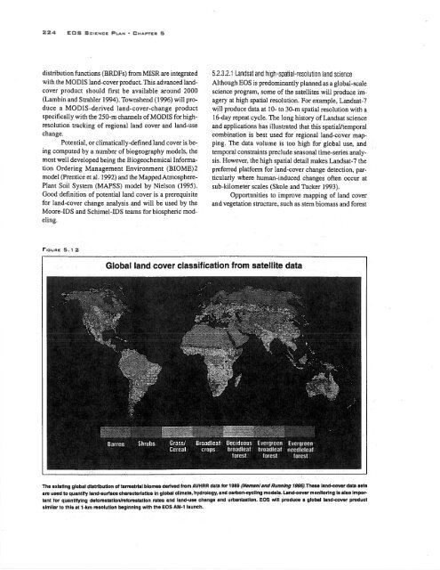
Global land cover classification from satellite data<br />
The existing global distribution of terrestrial biomes derived from AVHRR data for 1989 (Nemaniand Running 1995).These land-cover data sets<br />
are used to quantify land-surface characteristics in global climate, hydrology, and carbon-cycling models. <strong>Land</strong>-cover monitoring is also impor<br />
tant for quantifying deforestation/reforestation rates and land-use change and urbanization. EQS will produce a global land-cover product<br />
similar to this at 1-km resolution beginning with the EQS AM-i launch.