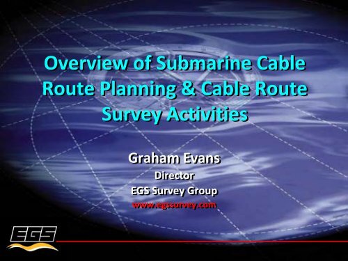
Overview of Submarine Cable Route Planning & Cable Route ...
Overview of Submarine Cable Route Planning & Cable Route ...
Overview of Submarine Cable Route Planning & Cable Route ...

You also want an ePaper? Increase the reach of your titles
YUMPU automatically turns print PDFs into web optimized ePapers that Google loves.
<strong>Overview</strong> <strong>of</strong> <strong>Submarine</strong> <strong>Cable</strong><br />
<strong>Route</strong> <strong>Planning</strong> & <strong>Cable</strong> <strong>Route</strong><br />
Survey Activities<br />
Graham Evans<br />
Director<br />
EGS Survey Group<br />
www.egssurvey.com
Presentation Summary<br />
<strong>Submarine</strong> <strong>Submarine</strong> cable systems ‐ concept to reality<br />
Objectives Objectives <strong>of</strong> route planning and marine route survey<br />
<strong>Planning</strong> <strong>Planning</strong> tools<br />
Desk Desk Top Studies<br />
<strong>Route</strong> <strong>Route</strong> survey technologies and applications<br />
The The cable route survey and UNCLOS provisions<br />
The The cable route survey –Why this activity does not<br />
constitute Marine Scientific Research<br />
Permitting Permitting and impact on project lead time
Concept to Reality –Key Phases<br />
Development <strong>of</strong><br />
Business Model<br />
Feasibility Study &<br />
Initial Engineering<br />
Pre Survey<br />
Desk Study<br />
<strong>Route</strong> Survey &<br />
Burial Assessment<br />
System Installation<br />
Definition <strong>of</strong> Key<br />
Project Milestones<br />
Define Permitting<br />
Requirements<br />
Secure System<br />
Permits in Principle<br />
Marine Operations<br />
Permitting<br />
Project Concept<br />
& Initial Investors<br />
Formation <strong>of</strong> Interim<br />
Management Team<br />
Supply Contract<br />
Processes<br />
<strong>Route</strong> Survey<br />
Contract Process
Key Project Milestones<br />
Completion <strong>of</strong> Business Case<br />
Completion <strong>of</strong> Feasibility Study –this should include<br />
Clear definition <strong>of</strong> permit requirements and responsibilities<br />
Clear understanding <strong>of</strong> permit lead times<br />
Target RFPA date<br />
Issue <strong>of</strong> Supply Contract RFQ<br />
Award <strong>of</strong> Supply Contract<br />
Complete securing <strong>of</strong> system Permits in Principle<br />
Completion <strong>of</strong> Pre Survey Desktop Study<br />
Completion <strong>of</strong> <strong>Route</strong> Survey<br />
Completion <strong>of</strong> installation<br />
Complete commissioning<br />
RFPA
Permitting & Impact on Project<br />
Programs & <strong>Planning</strong><br />
Varying permit lead times can lead to project planning and<br />
implementation phase dislocation if not properly sequenced<br />
Identification <strong>of</strong> permit interdependency a critical factor in<br />
project planning<br />
Impact <strong>of</strong> variations in permit lead times on project planning:<br />
Minimal when dealing with domestic national systems<br />
Most complex for long haul international systems with highly<br />
variable national jurisdictional requirements<br />
Impact <strong>of</strong> route transits through non landing country jurisdictions:<br />
Can lead to protracted negotiations when transits are through<br />
territorial waters and/or contiguous zones<br />
Complexities when either jurisdictional agencies approached late or<br />
not at all; or when unpredicted changes or routing requirements<br />
imposed<br />
Problems associated with conflicts with UNCLOS protocols for<br />
coastal states that have ratified UNCLOS
<strong>Planning</strong> & Survey Objectives<br />
To To develop optimised routing between defined landing<br />
sites that meets economic and technical viability<br />
criteria including:<br />
Avoidance <strong>of</strong> or minimising conflicts with other seabed users<br />
Minimising exposure to natural and manmade risks and<br />
hazards<br />
Optimising cable engineering and protection<br />
System maintainability<br />
Adherence to ICPC Protocols and Recommendations
Available <strong>Planning</strong> Tools<br />
GIS Databases<br />
Geo<strong>Cable</strong><br />
In‐house from historic data<br />
Geoscience institutions<br />
<strong>Route</strong> planning s<strong>of</strong>tware tools<br />
MakaiPlan<br />
Map Info<br />
Bespoke satellite imagery tasking<br />
Web based interactive imagery<br />
Google Earth
<strong>Planning</strong> Tool Applications<br />
GIS Databases – Inputs to Feasibility & Desktop Studies<br />
<strong>Cable</strong> fault histories<br />
Location <strong>of</strong> existing (and planned) cables and repeaters<br />
Location <strong>of</strong> existing and planned pipelines<br />
Maritime boundary delimitations<br />
Offshore oil & gas lease block boundaries<br />
Offshore mining lease block boundaries<br />
Military exercise areas<br />
Dumping grounds<br />
Marine park boundaries<br />
Geoscience inputs (metocean, tectonics, volcanism)
<strong>Planning</strong> Tool Applications<br />
<strong>Route</strong> planning s<strong>of</strong>tware tools – Inputs to Feasibility &<br />
Desktop Studies<br />
Pre survey RPL & SLD development<br />
Pre survey cable type selection<br />
Final post survey (or survey concurrent) RPL & SLD<br />
development<br />
Final post survey (or survey concurrent) cable engineering<br />
Web based interactive imagery<br />
Qualitative early landing site evaluation<br />
Qualitative identification <strong>of</strong> some hazards
Strait Line Diagram<br />
<strong>Route</strong> Position List
Pre Survey Desktop Study<br />
Output from planning activities will be input to a pre survey<br />
DTS<br />
Risk and hazards for each route section will be assessed and<br />
summarized in a Risk Matrix<br />
In addition to archival research, the desk study will<br />
document information gathered from visits to the system<br />
landing sites<br />
The DTS will recommend appropriate route survey<br />
procedures designed to prove viability <strong>of</strong> the pre survey<br />
planning effort
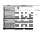
REGION<br />
Landing site Inner Shelf<br />
(0‐70mwd)<br />
Landing site Outer Shelf<br />
(70‐150mwd)<br />
Outcrops<br />
Cemented<br />
Sediment<br />
Slope Instability<br />
Table XX:<br />
Seismicity/<br />
Faulting<br />
Volcanic<br />
Activity<br />
Risk Summary along the ANY‐1 <strong>Cable</strong> <strong>Route</strong><br />
Tsunamis Steep Slopes<br />
RISK CATEGORY<br />
Bottom<br />
Currents<br />
Fishing Activities<br />
Resources<br />
Exploration<br />
Shipping<br />
Activity/<br />
Anchoring<br />
<strong>Cable</strong> Congestion<br />
Military<br />
Activities/ UXO<br />
H L L L L L L H M M M H M M<br />
L H L L L L L M M M M M M M<br />
Continental Slope M L M L L L M M M L L L M M<br />
XXX Basin L L L L L L L M L L L L L L<br />
XXX Ridge L L L L L L M L L L L L L L<br />
XXX Basin L L L L L L L L L L L L L L<br />
XXX Basin L L L L L L L L L L L L L L<br />
XXX Rise L M L L L L M L L L L L L L<br />
XXX Basin L L L L L L L L L L L L L L<br />
Landing 2 approach H M M L M M M L L L L L M M<br />
XXX Sea L L L L L L M L L L L L L L<br />
Landing 3 approach H M L M L L L L L L L L L L<br />
XXX Sea M M M M M M H L L M L L L L<br />
South XXX Trench M M M M M L M M L L L L L L<br />
XXX Trench M M H H L L M M L L L L L L<br />
XXX Islands M L L L M L L L L L L L L L<br />
XXX Strait M L M M M L M M L L L L L L<br />
Landing 4 approach M L M M M M M M L L M L L L<br />
XXX Sea M L L H H M L L L L L L L L<br />
XXX Plateau L L L L L L L L L L L L L L<br />
East XXX Seamounts L L L L L L L L L L L L L L<br />
East XXX Basin M L L M M L L L L L L L L L<br />
XXX Trench H L M M M L H L L L L L L L<br />
Landing 5 approach H L H M M M H L L L L M M M<br />
LEVELS OF RELATIVE CONCERNS<br />
High (H) Available data indicate a significant risk and continuing concern from this source<br />
Medium (M) Available data indicate a possible risk that needs to be better assessed<br />
Low (L)<br />
Available data indicate that while present continuously or intermittently in some areas,<br />
this concern is unlikely to affect cable integrity<br />
Wrecks/<br />
Debris
The <strong>Route</strong> Survey<br />
Provides information required to confirm or amend the<br />
preliminary pre survey DTS route<br />
Defines and documents the final route<br />
Enables final cable engineering to be defined<br />
Provides the system installer with the data required to<br />
finalize installation procedures<br />
Identifies potential post installation/residual hazards<br />
including unmitigated risks from potential tectonic activity<br />
during the system design life
<strong>Route</strong> Survey Offshore Vessel
<strong>Route</strong> Survey Data Sets<br />
Data Data is collected along a narrow strip <strong>of</strong> seabed, typically 500m<br />
to 3 x water depth wide and includes:<br />
Bathymetric data –seabed topography<br />
Sonar imagery data –seabed surface features<br />
Sub‐bottom pr<strong>of</strong>iling data – shallow sub surface soil pr<strong>of</strong>ile<br />
Burial assessment data –mechanical properties <strong>of</strong> the seabed soils<br />
within the planned burial pr<strong>of</strong>ile (typically 1m to 3m)<br />
Geophysical Geophysical and soils data usually only collected where cable<br />
protection by burial is planned typically up to a maximum water<br />
depth <strong>of</strong> 1,000m; rarely up to 2,000m<br />
Only Only bathymetric data collected in deep water
Multibeam Bathymetry<br />
Bathymetry and co‐<br />
located back‐scatter data<br />
Digital data output can be<br />
rapidly processed and<br />
analysed<br />
Data used to develop<br />
seabed terrain model<br />
Resolution <strong>of</strong> multibeam<br />
systems is altitude<br />
dependant
High Resolution in Shallow Water
High Resolution in Shallow Water
Deep water data<br />
Philippine Trench maximum depth<br />
10,400m
Side Scan Sonar Imagery<br />
Towed systems<br />
Depth range up to 3000m<br />
Provide images <strong>of</strong> seabed<br />
surface features<br />
Surface back‐scatter<br />
intensity can be used as<br />
indicator <strong>of</strong> seabed<br />
hardness
Side Scan Sonar Imagery
Sub‐bottom Data
Gravity coring<br />
Cone Penetrometer Tests<br />
measure<br />
Tip resistance<br />
Sleeve friction<br />
Resistivity<br />
Typically to 3m below seabed<br />
Used to predict and<br />
categorize cable plough burial<br />
performance<br />
Burial Assessment
Short reporting leadtimes<br />
have led to:<br />
On-board data<br />
acquisition,<br />
processing &<br />
charting<br />
Telemetry <strong>of</strong><br />
processed data to<br />
shore based <strong>of</strong>fices<br />
Data output direct to<br />
route planning<br />
s<strong>of</strong>tware (Makai)<br />
Final reporting<br />
typically <strong>of</strong>fice based
UNCLOS –Provisions & Application<br />
<strong>Cable</strong> route surveys are part <strong>of</strong> the process <strong>of</strong> laying submarine cables<br />
10 articles <strong>of</strong> UNCLOS govern the activities related to cables in the<br />
territorial sea, the EEZ, the continental shelf and the high seas<br />
The freedom to navigate and lay cables and the operations associated<br />
with ships exercising these freedoms are expressly provided for under<br />
these articles<br />
In reality, an increasing number <strong>of</strong> costal states are now insisting on<br />
permits; or the lesser, but no less program challenging, Letters <strong>of</strong> No<br />
Objection issued by the coastal state, for survey and cable installation<br />
within their EEZ<br />
The justification <strong>of</strong>ten given by coastal states imposing these<br />
permitting restrictions, is that the route survey constitutes Marine<br />
Scientific Research, the tools and methodology <strong>of</strong> which being similar
<strong>Cable</strong> <strong>Route</strong> Surveys<br />
Why this activity is not<br />
Marine Scientific Research<br />
The The fundamental objective <strong>of</strong> the cable route<br />
survey is to:<br />
Prove and document the initial route developed during<br />
initial project planning stages<br />
Identify and where practical, develop the initial route to<br />
avoid obstructions and hazards found during the survey<br />
Determine final cable engineering and cable quantities<br />
Confirm or amend preliminary cable protection strategies<br />
Provide all data and documentation necessary to support<br />
cable installation<br />
Provide the database framework for system maintenance
<strong>Cable</strong> <strong>Route</strong> Surveys<br />
Why this activity is not<br />
Marine Scientific Research<br />
Marine Scientific Research is not defined in the Convention;<br />
however, it is clear that the scope <strong>of</strong> submarine cable route<br />
surveys cannot be construed as Scientific Research<br />
The route survey scope is not designed to perform systematic<br />
investigations into and study <strong>of</strong> the marine environment in order to<br />
establish facts and reach new conclusions about the marine<br />
environment, nor<br />
To carry out exploration or exploitation <strong>of</strong> living or non living<br />
resources<br />
Drill on the continental shelf<br />
Use explosives or harmful substances<br />
Construct, operate or use artificial islands, installations or structures
Permits<br />
Program Impacts & Consequences<br />
Requirement for survey vessel to mobilize in advance <strong>of</strong> all<br />
survey operational permits being issued has resulted in:<br />
Inability to commence operations upon arrival on site<br />
Dislocation <strong>of</strong> planned survey phase sequence<br />
Protracted vessel standby<br />
Long out <strong>of</strong> sequence and non productive vessel transits<br />
Increased costs through consequential Contract Variations<br />
Substantial overall project delays with loaded installation vessels<br />
idle waiting on survey data and installation permits<br />
Increasing requirement for marine operational permits in<br />
EEZs particularly for non landing countries in “apparent”<br />
contravention <strong>of</strong> UNCLOS provisions has further negatively<br />
impacted permit lead time and project progress
Permits<br />
Program Impacts & Consequences<br />
In the case <strong>of</strong> recent projects in the Red Sea, Gulf <strong>of</strong> Aden<br />
and Arabian Sea, permit delays caused survey work to be<br />
pushed into the Southwest Monsoon with the attendant<br />
weather delays and negative impact on survey data quality<br />
The one permit at a time policy <strong>of</strong> adopted by some<br />
countries has required out <strong>of</strong> sequence survey operations,<br />
long transits between permitted and non permitted routes<br />
further escalating cost
Survey Permits & Conditions<br />
Securing permissions to carry out survey operations vary from<br />
coastal state to coastal state and from straightforward to highly<br />
complex with lead‐times measured in days to many months;<br />
associated conditions can include:<br />
Requirement for all survey team members and vessel crew to undergo<br />
security checks<br />
The imposition <strong>of</strong> restrictions on certain nationalities within the survey<br />
team and/or vessel crew; and even the country where the survey<br />
contractor’s company is registered<br />
Requirement for survey operations to be witnessed by security <strong>of</strong>ficers<br />
Mandate for survey work be conducted by national research institutes to<br />
pre agreed hand over locations<br />
Requirement for copies <strong>of</strong> survey data to be made available to the<br />
coastal state upon completion <strong>of</strong> the survey and/or copies <strong>of</strong> reports
Questions & Clarifications<br />
Questions and clarifications on the content <strong>of</strong> this<br />
presentation or related matters can be addressed to:<br />
Graham Evans –E‐mail gevans@egssurvey.com