

The capture and dissemination of integrated 3D geospatial ...
The capture and dissemination of integrated 3D geospatial ...
The capture and dissemination of integrated 3D geospatial ...

Create successful ePaper yourself
Turn your PDF publications into a flip-book with our unique Google optimized e-Paper software.
310<br />
311<br />
312<br />
313<br />
314<br />
315<br />
316<br />
317<br />
318<br />
319<br />
320<br />
321<br />
322<br />
323<br />
324<br />
325<br />
326<br />
327<br />
328<br />
329<br />
330<br />
331<br />
332<br />
333<br />
334<br />
335<br />
years <strong>of</strong> research into systems <strong>and</strong> methods for <strong>3D</strong> modeling (Smith, 2005). <strong>The</strong> products,<br />
known collectively as LithoFrame are described more fully on the BGS website [3] . <strong>The</strong>se<br />
LithoFrame models will be structured <strong>and</strong> attributed to meet the needs <strong>of</strong> a wide range <strong>of</strong><br />
applied users, <strong>and</strong> ultimately, will take the place <strong>of</strong> the traditional geological map. However,<br />
this will only happen if the models are produced on a national scale, at realistic costs, <strong>and</strong> are<br />
made available <strong>and</strong> accessible to the user community (Jackson, 2005; Turner, 2006).<br />
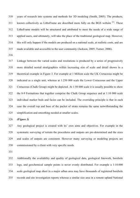
Linkage between the varied scales <strong>and</strong> resolutions is produced by a series <strong>of</strong> progressively<br />
more detailed nested stratigraphies within increasing size <strong>of</strong> scale <strong>and</strong> detail shown in a<br />
theoretical example in Figure 3. For example at 1 Million scale the UK Cretaceous might be<br />
indicated as a single unit, whereas at 1:250 000 scale the Lower Cretaceous <strong>and</strong> the Upper<br />
Cretaceous (Chalk Group) might be depicted. At 1:50 000 scale it is usually possible to show<br />
the 8-9 Formations that together comprise the Chalk Group sequence <strong>and</strong> at 1:10 000 scale<br />
individual marker beds <strong>and</strong> facies can be included. <strong>The</strong> overriding principle is that in each<br />
case the overall top <strong>and</strong> base <strong>of</strong> the packet <strong>of</strong> strata remains the same notwithst<strong>and</strong>ing the<br />
simplification <strong>and</strong> smoothing needed at smaller scales.<br />
(Figure 3)<br />
Any geological project is created with its’ own aims <strong>and</strong> objectives. For example in the<br />
systematic surveying <strong>of</strong> terrain the procedures <strong>and</strong> outputs are pre-determined <strong>and</strong> the sizes<br />
<strong>and</strong> scales <strong>of</strong> outputs are consistent. However many surveying or modeling projects are<br />
commissioned by a client with very specific needs.<br />
Additionally the availability <strong>and</strong> quality <strong>of</strong> geological data, geological linework, borehole<br />
logs, <strong>and</strong> geochemical sample points is never evenly distributed. For example a 1:10.000<br />
scale geological map sheet in a major urban area may have thous<strong>and</strong>s <strong>of</strong> registered borehole<br />
records <strong>and</strong> site investigation reports whereas a similar size area in a remote upl<strong>and</strong> National


