butrint Putting Together a City's History by Studying Its Walls
butrint Putting Together a City's History by Studying Its Walls
butrint Putting Together a City's History by Studying Its Walls

You also want an ePaper? Increase the reach of your titles
YUMPU automatically turns print PDFs into web optimized ePapers that Google loves.
utrint<br />
unraveling<br />
<strong>butrint</strong><br />
<strong>Putting</strong> <strong>Together</strong> a City’s<br />
<strong>History</strong> <strong>by</strong> <strong>Studying</strong> <strong>Its</strong> <strong>Walls</strong><br />
10 volume 51, number 3 expedition<br />
<strong>by</strong> james g. schryver<br />
The Butrint Foundation
The Butrint Foundation<br />
puzzles and pieces<br />
“You like a good puzzle, don’t you?” These were the words<br />
with which Richard Hodges, the Scientific Director of the<br />
Butrint Foundation, began my first tour of the fortifications<br />
of Butrint. Like most archaeologists, I immediately answered<br />
“yes.” About two hours later, I realized that what he should<br />
have asked me was whether I liked ten good puzzles, with<br />
some of the pieces missing, all of the rest mixed together, and<br />
only a few scattered and torn pieces of a box top to guide me.<br />
<strong>Studying</strong> the various bits of wall and fortification at Butrint<br />
in order to piece together their history has proven to be just<br />
such an exercise. Although I might not have answered him as<br />
quickly had I known this, in the end the task proved both ten<br />
times as interesting and ten times as rewarding. By examining<br />
the various building phases of Butrint’s fortifications, it<br />
became possible to tell quite an interesting story about the<br />
walls that surround the site and how they both determined<br />
and reflected where the inhabitants entered the city and what<br />
parts of it they used over time.<br />
Known in the past as Buthrotum, Butrint is located in<br />
Albania near the border separating that country from Greece.<br />
Situated on a promontory at the edge of a large saltwater lake,<br />
it provides visitors with breathtaking views of portions of the<br />
lake and surrounding hills, the Straits of Corfu, and the channel<br />
and marshlands that connect them. These views make a<br />
visit to the site unforgettable.<br />
In the 1990s, however, this scenic setting nearly led to<br />
the area’s demise. When Albania’s communist government<br />
was forced to resign in 1991, and the country emerged from<br />
30 years of self-imposed and devastating isolation, developers<br />
began to gaze hungrily on the site and its surrounding<br />
landscape. It is largely through the efforts of the Butrint<br />
Foundation, and its main backers, Lord Rothschild and Lord<br />
Sainsbury of Preston Candover, that the site was preserved<br />
from development. Butrint has since become further protected<br />
as a UNESCO World Heritage Site, and the area around<br />
it is also now preserved as part of a national park.<br />
Scientific investigations at the site began in earnest in 1994<br />
when the Butrint Foundation partnered with the Albanian<br />
Institute of Archaeology to initiate a project examining the<br />
Byzantine phase of the city. As part of this project, an initial<br />
survey of the walls was completed, which served as the foundation<br />
for the present study. Most important was the identification<br />
of a number of major phases or episodes of construction<br />
including two that were thought to have occurred during the<br />
The World Heritage site of Butrint is located near the southern border<br />
of present-day Albania. The site, along with much of the coast, is visible<br />
from certain parts of Corfu. An hour and a half boat ride from the island,<br />
followed <strong>by</strong> a short car ride from the Albanian port of Saranda, is still the<br />
most convenient way for Westerners to visit the site.<br />
Middle Ages. Additional excavations and projects, including<br />
the work described here, have started to examine other phases<br />
of the site’s 3,000-year history as well. Throughout, archaeological,<br />
historical, and environmental investigations at the site<br />
have been based on an integrative approach that focuses not<br />
only on architecture and artifacts but also on the landscape<br />
setting and immediate environs. In addition, work has been<br />
guided <strong>by</strong> the recognition of just how much modern-day decisions<br />
can affect this treasure from the past, and <strong>by</strong> the practice<br />
of integrating conservation/preservation and presentation<br />
to the public into the program of excavation and study. As<br />
a result of these past and continuing efforts, Butrint thrives<br />
today as a popular tourist destination, and our knowledge and<br />
understanding of the site continue to grow.<br />
www.penn.museum/expedition 11
utrint<br />
12 volume 51, number 3 expedition<br />
James G. Schryver
James G. Schryver<br />
The task assigned <strong>by</strong> Richard Hodges—to sort out,<br />
organize, and assemble the pieces making up the history of<br />
Butrint’s walls and fortifications—was part of a three-pronged<br />
reassessment of the site. Other aspects included a translation<br />
into English of the seminal work on the fortifications <strong>by</strong> the<br />
former head of the Albanian Institute of Monuments, Gjerak<br />
Karaiskaj, and the planning and implementation of conservation<br />
and presentation programs related to an expected increase<br />
in tourism at Butrint. This reassessment was crucial to the<br />
future of the site, as my co-investigator, Andrew Crowson, and<br />
I soon learned in carrying out our study. Once one stepped<br />
away from the main paths, the same vegetation that makes<br />
the area so beautiful was destroying those very parts of the site<br />
that we were trying to study and preserve. Unfortunately, the<br />
path of least resistance for many visitors investigating Butrint<br />
was often along the tops of its crumbling walls. The summer<br />
of 2007 saw the implementation of an extensive de-vegetation<br />
program that cleared areas of ruins and provided safer routes<br />
of access for visitors.<br />
sorting out the pieces<br />
Like anyone facing a complicated puzzle, Andrew and I used all of<br />
the aids available to us. Our “box top” was the Butrint Foundation’s<br />
archive of photographs from the Italian Archaeological Mission’s<br />
1928–1943 work at the site under the leadership of Luigi Maria<br />
Ugolini (see article in this issue). These images were supplemented<br />
<strong>by</strong> later photographs taken <strong>by</strong> the Albanian Institute of<br />
Monuments. We were also fortunate to have access to Ugolini’s<br />
field notes, which were long thought to have vanished, but had<br />
been rediscovered <strong>by</strong> the Butrint Foundation scattered throughout<br />
various archives in Italy and Albania. Reading through these<br />
notes was like stepping back in time. One could almost feel the<br />
Left, top, a view from the top of the castle walls toward the west. The watchtower seen in the middle ground of the photo, just above the modern road,<br />
commands views up and down the Vivari Channel. Left, bottom, a view from the watchtower back toward the east. It is interesting to note that the<br />
windows of the tower all focused on the channel itself as opposed to the castle. Although there may have originally been an upper wooden platform, in<br />
order to get a clear view of the castle today, one needs to exit the tower. The Venetian triangular fortress can be seen on the right bank of the channel.<br />
Above, a general view of the castle and surroundings from the northeast shows the dominant position of the castle on the acropolis and the northern<br />
wall spur traveling down to the water’s edge.<br />
www.penn.museum/expedition 13
utrint<br />
heat and hear the buzzing of the mosquitoes that plagued the<br />
excavators during the summer months.<br />
Our first order of business involved ferreting out and retrieving<br />
the information pertinent to the walls and fortifications<br />
contained in the Italian Archaeological Mission’s archives. After<br />
reviewing this information, the next step was to go through the<br />
publications on the walls of Butrint to get an idea of when and<br />
where the existing photographs had been taken. Of course,<br />
these photos would come to make a lot more sense after the<br />
actual field-based survey was underway, but it was helpful to<br />
have all of the images in mind while we carried out our work.<br />
Despite the benefits of having the old photographs in hand,<br />
nothing could substitute for walking around, touching, and<br />
studying the walls themselves. That is when the real sorting of<br />
the pieces occurred. With some idea of the different groups<br />
(various walls and building campaigns) into which we might<br />
organize the available clues, we began to assemble our data.<br />
To the notes and photographs we added copies of the general<br />
plan of the city that had been established <strong>by</strong> the IWA (Institute<br />
of World Archaeology, University of East Anglia, Norwich,<br />
England) from 1994 to1999 as part of the Butrint Foundation’s<br />
investigations at the site. We then set off with a notebook, a<br />
tape measure, and a digital camera to record our impressions<br />
of the various phases of the walls. Over the course of two weeks,<br />
we walked and studied every inch of Butrint’s fortifications.<br />
Although we spent time examining what was believed to be<br />
a medieval wall circuit constructed around the lower city and<br />
the various refurbishments of the original Hellenistic defenses<br />
in this area, we focused primarily on Butrint’s acropolis. Much<br />
like the rest of the site, this area included remains from the<br />
Hellenistic period (ca. 323–31 BC) through to the 1930s.<br />
Fortunately, we had the chance to make one of our first study<br />
circuits around the site with Professor Karaiskaj, mentioned<br />
above. It was during these trips that we also made many observations<br />
concerning the existing preservation of the walls and<br />
the potential danger posed <strong>by</strong> vegetation.<br />
reassembling the pieces<br />
Our main goals in studying various sections of the walls were<br />
to figure out what the acropolis fortifications actually looked<br />
like, how they functioned over time, and how they were<br />
approached and defended. In general, we found that the broad<br />
14 volume 51, number 3 expedition<br />
construction sequences that had been established <strong>by</strong> the IWA<br />
survey held true, with one major and several minor exceptions.<br />
However, as might be expected, our more in-depth study of<br />
the walls and fortifications led to a more nuanced view of the<br />
complex history of Butrint. One interesting conclusion we<br />
reached was that a glacis (a sloping stone wall built to protect<br />
the base of a vertical wall) on the northern side of the citadel,<br />
which was one of the key walls for any argument concerning<br />
the Venetian works at the site (ca. AD 1386–1797), turned out<br />
to have been constructed <strong>by</strong> Ugolini and his team. In this case<br />
and others, where we were able to identify the walls that dated<br />
to the 1930s, the collection of photographs from Ugolini’s<br />
expedition proved indispensable. An example of their usefulness<br />
is provided <strong>by</strong> the pictures of the castle’s main tower. This<br />
is especially true because, as Ugolini himself noted, the workmen<br />
did their best to match both the stones and building style<br />
of the original when they rebuilt various walls.<br />
As a result of our survey, we were able to add details to the<br />
general history of the walls, and we now know that what was<br />
considered a “simple” medieval castle and fortification system<br />
was actually quite complex. For example, projecting towers<br />
were spaced irregularly around the circumference of the walls.<br />
That they were part of the original construction plans was<br />
indicated <strong>by</strong> the fact that they were keyed into the portions of<br />
walls near<strong>by</strong>. We also discovered multiple gates in the acropolis<br />
wall located next to towers that we identified. However, no<br />
evidence of entrances through the towers themselves could be<br />
found. In almost all cases, the pieces that would have provided<br />
this evidence were completely missing, and we were left with<br />
only Ugolini’s notes indicating that he thought such entrances<br />
existed. Only future excavation has the potential to provide<br />
this information and definitively lay the issue to rest.<br />
We also learned something interesting about one of the<br />
mysteries of these walls. Previous attempts to explain the<br />
apparent variations in construction style within phase I of the<br />
medieval city walls, which were thought to have been constructed<br />
sometime in the 13th century (although more recent<br />
discoveries point to the possibility of an 11th century intervention),<br />
have proposed that these were due to differences in<br />
the “personal” style of various work gangs. It was therefore<br />
assumed that places where different styles of masonry joined<br />
along a wall were simply areas where two construction gangs<br />
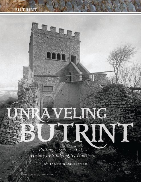
Right, a view of the main existing tower and walls of the castle of Butrint taken <strong>by</strong> the Italian Archaeological Mission. A comparison of the<br />
images reveals the extent of reconstruction carried out <strong>by</strong> Ugolini and his team. Other photographs and maps indicate that the remains of at<br />
least three other towers (two of them at corners of the castle) were covered <strong>by</strong> Ugolini’s reconstruction.
The Butrint Foundation<br />
www.penn.museum/expedition 15
utrint<br />
A plan of the site based on the work carried out <strong>by</strong> the Butrint Foundation<br />
from 1994-1999. This was the base map for our 2004 study.<br />
had met. Our work showed that the variety in style might further<br />
be explained <strong>by</strong> the incorporation of recycled building<br />
materials—sometimes more carefully cut and of higher quality—which<br />
were reassembled into the acropolis wall in those<br />
areas. Our study suggested that there may have been some<br />
clearance work associated with the building of these walls and<br />
that the builders were reluctant to let any of the dismantled<br />
materials go to waste. What is more, in a few cases along the<br />
northern wall, the edges of older, reused foundations seemed<br />
to stick out from underneath. To confuse the issue even further,<br />
we also discovered what appeared to be numerous patching<br />
and repair jobs that had been carried out on the walls over<br />
the centuries, perhaps in response to damage inflicted <strong>by</strong><br />
severe weather or earthquakes. Below the acropolis, the picture<br />
that emerged was one in which the medieval walls enclosing<br />
the lower city were a mix of segments built on top of the<br />
late Roman circuit and original constructions.<br />
16 volume 51, number 3 expedition<br />
No pre-medieval defenses encircled the acropolis, as had<br />
been previously assumed. The acropolis wall circuit, castle<br />
bailey, and outworks were constructed during the Medieval<br />
Phase I building program (13th, possibly 11th century AD).<br />
Although only one tower exists today, a second tower, only<br />
apparent in a series of photographs from the 1930s (see photograph<br />
on page 22), also guarded the eastern edge (and possible<br />
entrance) of the enclosure. From the photographs, it appears<br />
that this arrangement was similar to the castellan’s residence<br />
at Agirokastro on the island of Corfu. Once established,<br />
with few exceptions, this layout was not drastically altered.<br />
The Phase I walls were, however, substantially repaired during<br />
the Medieval Phase II building program. In a few cases<br />
they were wholly rebuilt in what appeared to be an attempt<br />
to reorganize or restrict access to the acropolis and castle.<br />
The Phase II repairs and additions are hard to pin down<br />
chronologically, but the overall impression one gets of “battening<br />
down the hatches” suggests the rule of the Epirote<br />
Despot Michael II (AD 1230–1266) and the period of Angevin<br />
rule in the late 13th and 14th centuries as likely candidates.<br />
Charles of Anjou took the title of King of Albania in February<br />
of 1272, and the Regnum Albaniae lasted until 1368 as<br />
a dependency of the Kingdom of Sicily. During this period,<br />
Butrint changed hands multiple times. The extent of the<br />
work carried out on the defenses also fits with new rulers at<br />
Butrint who would have come in and redesigned, or more<br />
likely re-fortified, their new property. Later patchwork and<br />
repairs must be those mentioned in documents from the<br />
Venetian archives. Interestingly, the same archives indicate<br />
that a medieval labor struggle was taking place related<br />
to whether local Albanians or Corfiotes were to man these<br />
fortifications. It appears that the Corfiotes won out, as a<br />
1454 document mentions that they used great valor in<br />
defending Butrint from a siege <strong>by</strong> 10,000 Turks led <strong>by</strong><br />
Caniz Zibei.<br />
The later acropolis castle included a lower, subsidiary enclosure,<br />
which was reinforced and made more complex along the<br />
western side. The gateway leading up to the acropolis, located<br />
off the northwest corner of the castle, was formidably strengthened<br />
at this point. Those responsible for the Phase II walls also<br />
restructured and severely limited the access to the citadel <strong>by</strong> funneling<br />
everyone along the western side of the hilltop and clockwise<br />
around the northwest corner. At the same time, they closed<br />
off all of the other gates in the acropolis wall built during the<br />
Medieval Phase I fortification of the promontory.<br />
The Butrint Foundation
Andrew Crowson<br />
The results of our survey, combined with continuing<br />
research conducted <strong>by</strong> the Butrint Foundation, suggest<br />
that the main phases of the Butrint castle did not begin<br />
with a Hellenistic, or even a Byzantine, walled citadel as<br />
previously thought. Instead, they began with a poorly<br />
preserved later castrum or fortress (13th, possibly<br />
11th century AD) at the west end of the acropolis. This<br />
was part of the major wall-building program that we<br />
have labeled Medieval Phase I. Access to the acropolis<br />
seems to have been quite open during this phase with<br />
a possible major entrance located along the southern<br />
acropolis wall. This fortification system was strengthened<br />
during the 13th to 14th centuries as part of an<br />
effort that reconfigured the access routes to the acropolis<br />
and closed off the northern area of the promontory<br />
as well as any direct passages between this area and the<br />
acropolis. Rather than a third phase of construction<br />
during the 16th century under the Venetians, as originally<br />
assumed, the citadel, it now appears, was actually<br />
deserted during this period in favor of a Venetian<br />
tower and triangular castle on the northern and southern sides<br />
of the Vivari Channel, respectively. The triangular castle was<br />
strengthened in the 18th century and became the center of an<br />
Ottoman settlement in the early 19th century. In the end, this<br />
more general picture of continual demographic change in and<br />
around Butrint matches the image that is emerging of the premedieval<br />
city from more targeted excavations being carried out<br />
around the area of the Roman forum and on the Vrina Plain.<br />
Throughout its history, the city inhabitants reconfigured, replanned,<br />
and restructured access to Butrint and its environs to<br />
meet contemporary challenges, just as those who have recently<br />
taken the city under their care continue to do today.<br />
james g. schryver is Assistant Professor of Art <strong>History</strong> at<br />
the University of Minnesota, Morris. Over the last 13 years, he<br />
has led or participated in archaeological excavations around<br />
the Mediterranean and in Ireland. He assures us that he still<br />
loves puzzles.<br />
For Further Reading<br />
Crowson, Andrew. Venetian Butrint. London: Butrint Foundation, 2007.<br />
Gilkes, Oliver J., ed. The Theatre at Butrint: Luigi Maria Ugolini’s<br />
Excavations at Butrint 1928–1932 (Albania antica IV). London: British<br />
School at Athens, 2003.<br />
Right, photo of the author (left) with Gjerak Karaiskaj<br />
on the day of their tour around the city walls.<br />
Hansen, Inge Lyse, and Richard Hodges, eds. Roman Butrint: An<br />
Assessment. Oxford: Oxbow, 2007.<br />
Hodges, Richard. “Byzantine Butrint: New Discoveries from Albania.”<br />
Current World Archaeology 26 (2007):56-60.<br />
Hodges, Richard. The Rise and Fall of Byzantine Butrint. London:<br />
Butrint Foundation, 2008.<br />
Hodges, Richard, and Matthew Logue. “The Mid-Byzantine Re-birth of<br />
Butrint.” Minerva 18-3 (2007):41-43.<br />
Hodges, Richard, William Bowden, and Kosta Lako, eds. Byzantine<br />
Butrint: Excavations and Surveys 1994–1999. Oxford: Oxbow, 2004.<br />
Acknowledgments<br />
Left, one of the earlier<br />
gates into the city<br />
(Medieval Phase I), which<br />
was blocked as a result of<br />
subsequent repairs to the<br />
city walls (Medieval Phase<br />
II), that further restricted<br />
and re-routed the flow of<br />
traffic to the citadel.<br />
The author would like to thank the Butrint Foundation for their invitation<br />
and assistance on site and the Venetian Heritage Inc. and Packard<br />
Humanities Institute for funding this study. The main archaeological<br />
assessment was made from May 12 to May 29, 2004. Further archival<br />
research was conducted <strong>by</strong> the author during the summer of 2006.<br />
The principal investigators were Andrew Crowson (Institute of World<br />
Archaeology [IWA], UEA, Norwich, UK) and James G. Schryver (University<br />
of Minnesota, Morris). Crowson and Schryver were aided <strong>by</strong> Matthew<br />
Logue (National University of Ireland [NUI] – Galway). They were supported<br />
<strong>by</strong> Professor Richard Hodges (Scientific Director, Butrint Foundation)<br />
and Professor Gjerak Karaiskaj (Director, now retired, Institute of<br />
Monuments, Albania). The team was assisted <strong>by</strong> Nevila Molla (IWA).<br />
www.penn.museum/expedition 17