Steady state erosion of critical Coulomb wedges with applications to ...
Steady state erosion of critical Coulomb wedges with applications to ...
Steady state erosion of critical Coulomb wedges with applications to ...

You also want an ePaper? Increase the reach of your titles
YUMPU automatically turns print PDFs into web optimized ePapers that Google loves.
B01411 HILLEY AND STRECKER: STEADY STATE EROSION OF CRITICAL COULOMB WEDGES<br />
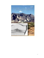
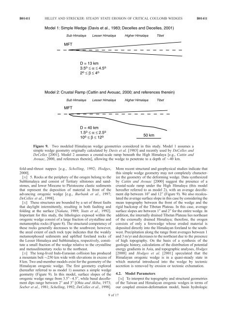
Figure 9. Two modeled Himalayan wedge geometries considered in this study. Model 1 assumes a<br />
simple wedge geometry originally calculated by Davis et al. [1983] and recently used by DeCelles and<br />
DeCelles [2001]. Model 2 assumes a crustal-scale ramp beneath the High Himalaya [e.g., Cattin and<br />
Avouac, 2000, and references therein], allowing the wedge <strong>to</strong> penetrate <strong>to</strong> a depth <strong>of</strong> 40 km.<br />
fold-and-thrust nappes [e.g., Schelling, 1992; Hodges,<br />
2000].<br />
[31] 5. Rocks at the periphery <strong>of</strong> the orogen belong <strong>to</strong> the<br />
Subhimalaya and consist <strong>of</strong> Tertiary silts<strong>to</strong>nes and sands<strong>to</strong>nes,<br />
and lower Miocene <strong>to</strong> Pleis<strong>to</strong>cene clastic sediments<br />
that represent the deposition <strong>of</strong> material in front <strong>of</strong> the<br />
advancing orogenic wedge [e.g., Burbank et al., 1997;<br />
DeCelles et al., 1998].<br />
[32] These structures are bounded by a set <strong>of</strong> thrust faults<br />
that daylight intermittently, resulting in both faulting and<br />
folding at the surface [Nakata, 1989; Yeats et al., 1992].<br />
Important for this study, the lithologies exposed <strong>with</strong>in the<br />
orogenic wedge consist <strong>of</strong> a large fraction <strong>of</strong> crystalline and<br />
metamorphic rocks (Figure 8). The structural competency <strong>of</strong><br />
these rocks generally decreases <strong>to</strong> the southwest; however,<br />
the areal extent <strong>of</strong> each rock type indicates that the weakly<br />
metamorphosed sediments and uplifted foreland rocks <strong>of</strong><br />
the Lesser Himalaya and Subhimalaya, respectively, constitute<br />
a small fraction <strong>of</strong> the wedge relative <strong>to</strong> the crystalline<br />
and metasedimentary rocks <strong>to</strong> the northeast.<br />
[33] The long-lived Indo-Eurasian collision has produced<br />
a mountain belt 250 km wide <strong>with</strong> elevations in excess <strong>of</strong><br />
8 km. Two end-member models exist for the geometry <strong>of</strong> the<br />
Himalayan orogenic wedge. The first geometry explored<br />
(hereafter referred <strong>to</strong> as model 1) assumes a simple wedge<br />
geometry (Figure 9). In this model, surface slopes <strong>of</strong> the<br />
orogenic wedge range from 3.5°–4.5°, while basal decollement<br />
dips range between 2° and 3° [Ohta and Akiba, 1973;<br />
Seeber et al., 1981; Schelling, 1992; DeCelles et al., 1998].<br />
9<strong>of</strong>17<br />
B01411<br />
More recent structural and geophysical studies indicate that<br />
this simple wedge geometry may not completely characterize<br />
the geometry <strong>of</strong> the deforming wedge. Data synthesized<br />
by Cattin and Avouac [2000] suggest the presence <strong>of</strong> a<br />
crustal-scale ramp under the High Himalaya (this model<br />
hereafter referred <strong>to</strong> as model 2), <strong>with</strong> an average decollement<br />
dip between 10° and 12° (Figure 9). We also recalculated<br />
the average surface slope in this case by considering the<br />
mean <strong>to</strong>pography between the front <strong>of</strong> the wedge and the<br />
rigid backs<strong>to</strong>p <strong>of</strong> the Tibetan Plateau. In this case, average<br />
surface slopes are between 1° and 2° for the entire wedge. In<br />
addition, the internally drained Tibetan Plateau lies northeast<br />
<strong>of</strong> the externally drained Himalaya; therefore, the orogen<br />
consists <strong>of</strong> only a forewedge whose eroded material is<br />
deposited directly in<strong>to</strong> the Himalayan foreland <strong>to</strong> the southwest.<br />
Precipitation along the range front averages between 1<br />
and 3 m/yr and decreases <strong>to</strong> the northeast due <strong>to</strong> the presence<br />
<strong>of</strong> high <strong>to</strong>pography. On the basis <strong>of</strong> a synthesis <strong>of</strong> the<br />
geologic his<strong>to</strong>ry, calculations <strong>of</strong> the distribution <strong>of</strong> potential<br />
energy gradients in Asia, and <strong>to</strong>pographic analyses, Hodges<br />
[2000] and Hodges et al. [2001] speculated that the<br />
Himalayan orogenic wedge is in a quasi-steady <strong>state</strong> in<br />
which material introduced in<strong>to</strong> the wedge by tec<strong>to</strong>nic<br />
accretion is removed by <strong>erosion</strong> or tec<strong>to</strong>nic exhumation.<br />
4.2. Model Parameters<br />
[34] To interpret the <strong>to</strong>pography and structural geometries<br />
<strong>of</strong> the Taiwan and Himalayan orogenic <strong>wedges</strong> in terms <strong>of</strong><br />
our coupled <strong>erosion</strong>-deformation model, basin hydrologic