Cirque forms and alpine glaciation during the Pleistocene, west ...
Cirque forms and alpine glaciation during the Pleistocene, west ...
Cirque forms and alpine glaciation during the Pleistocene, west ...
Create successful ePaper yourself
Turn your PDF publications into a flip-book with our unique Google optimized e-Paper software.
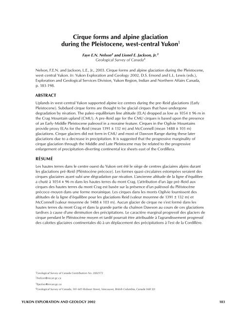
<strong>Cirque</strong> <strong>forms</strong> <strong>and</strong> <strong>alpine</strong> <strong>glaciation</strong><br />
<strong>during</strong> <strong>the</strong> <strong>Pleistocene</strong>, <strong>west</strong>-central Yukon 1<br />
Faye E.N. Nelson 2 <strong>and</strong> Lionel E. Jackson, Jr. 3<br />
Geological Survey of Canada 4<br />
Nelson, F.E.N. <strong>and</strong> Jackson, L.E., Jr., 2003. <strong>Cirque</strong> <strong>forms</strong> <strong>and</strong> <strong>alpine</strong> <strong>glaciation</strong> <strong>during</strong> <strong>the</strong> <strong>Pleistocene</strong>,<br />
<strong>west</strong>-central Yukon. In: Yukon Exploration <strong>and</strong> Geology 2002, D.S. Emond <strong>and</strong> L.L. Lewis (eds.),<br />
Exploration <strong>and</strong> Geological Services Division, Yukon Region, Indian <strong>and</strong> Nor<strong>the</strong>rn Affairs Canada,<br />
p. 183-198.<br />
ABSTRACT<br />
Upl<strong>and</strong>s in <strong>west</strong>-central Yukon supported <strong>alpine</strong> ice centres <strong>during</strong> <strong>the</strong> pre-Reid <strong>glaciation</strong>s (Early<br />
<strong>Pleistocene</strong>). Subdued cirque <strong>forms</strong> are thought to be glacial cirques that have undergone<br />
degradation by nivation. The paleo-equilibrium line altitude (ELA) dropped as low as 1054 ± 96 m in<br />
<strong>the</strong> Crag Mountain upl<strong>and</strong> (CMU). A pre-Reid age for <strong>the</strong> CMU cirques is based upon <strong>the</strong> presence<br />
of an Early-Middle <strong>Pleistocene</strong> paleosol in a moraine feature. <strong>Cirque</strong>s in <strong>the</strong> Ogilvie Mountains<br />
provide proxy ELAs for <strong>the</strong> Reid (mean 1391 ± 132 m) <strong>and</strong> McConnell (mean 1488 ± 103 m)<br />
<strong>glaciation</strong>s. <strong>Cirque</strong> glaciers did not form in CMU <strong>and</strong> most of Dawson Range <strong>during</strong> <strong>the</strong>se later<br />
<strong>glaciation</strong>s due to a decrease in precipitation. It is suggested that <strong>the</strong> progressive marginality of<br />
cirque <strong>glaciation</strong> through <strong>the</strong> Middle <strong>and</strong> Late <strong>Pleistocene</strong> may be related to <strong>the</strong> progressive<br />
enlargement of precipitation-diverting continental ice sheets east of <strong>the</strong> Cordillera.<br />
RÉSUMÉ<br />
Les hautes terres dans le centre ouest du Yukon ont été le siège de centres glaciaires alpins durant<br />
les <strong>glaciation</strong>s pré-Reid (Pléistocène précoce). Les formes quasi-circulaires estompées seraient des<br />
cirques glaciaires ayant subi une dégradation par nivation. L’ancienne altitude de la ligne d’équilibre<br />
a chuté à 1054 ± 96 m dans les hautes terres du mont Crag. L’attribution d’un âge pré-Reid aux<br />
cirques des hautes terres du mont Crag est basée sur la présence d’un paléosol du Pléistocène<br />
précoce-moyen dans une forme morainique. Les cirques dans les monts Ogilvie fournissent des<br />
altitudes de la ligne d’équilibre pour les <strong>glaciation</strong>s Reid (valeur moyenne de 1391 ± 132 m) et<br />
McConnell (valeur moyenne de 1488 ± 103 m). Aucun glacier de cirque ne s’est formé dans les<br />
hautes terres du mont Crag et dans la gr<strong>and</strong>e partie du chaînon Dawson au cours de ces <strong>glaciation</strong>s<br />
tardives à cause d’une diminution des précipitations. Le caractère marginal progressif des glaciers de<br />
cirque pendant le Pléistocène moyen et tardif pourrait être attribuable à l’agr<strong>and</strong>issement progressif<br />
des calottes glaciaires continentales dû à un déplacement des précipitations à l’est de la Cordillère.<br />
1 Geological Survey of Canada Contribution No. 2002172<br />
2 fnelson@nrcan.gc.ca<br />
3 lijackso@nrcan.gc.ca<br />
4 Geological Survey of Canada, 101-605 Robson Street, Vancouver, British Columbia, Canada V6B 5J3<br />
YUKON EXPLORATION AND GEOLOGY 2002 183
GEOLOGICAL FIELDWORK<br />
INTRODUCTION<br />
The surfi cial geology of a large area of <strong>west</strong>-central Yukon<br />
(Stewart River 1:250 000 map area (115N <strong>and</strong> 115O) <strong>and</strong><br />
adjacent areas) is currently being mapped as part of <strong>the</strong><br />
Geological Survey of Canada’s Ancient Pacifi c Margin<br />
NATMAP project. Defi ning <strong>the</strong> limits of past glacial ice<br />
cover is a key component in this endeavour. Bostock<br />
(1966) established limits of past regional <strong>glaciation</strong>s.<br />
These pertain to areas covered by past Cordilleran ice<br />
sheets. However, recent investigation of cirque-like<br />
features <strong>and</strong> glacial l<strong>and</strong><strong>forms</strong> in <strong>the</strong> Sixtymile River basin<br />
(Lowey, 2000), mapping of degraded cirques in <strong>the</strong><br />
Dawson Range (Jackson, 2000), <strong>and</strong> mapping of<br />
l<strong>and</strong><strong>forms</strong> <strong>and</strong> glacial erratics in <strong>the</strong> Yukon-Tanana Upl<strong>and</strong><br />
of adjacent Alaska (Weber, 1986) have suggested that<br />
cirque, valley or small ice cap <strong>glaciation</strong> may have existed<br />
earlier in <strong>the</strong> <strong>Pleistocene</strong> at elevations common within<br />
upl<strong>and</strong>s of <strong>the</strong> Stewart River map area.<br />
There are signifi cant problems inherent in gaining more of<br />
an underst<strong>and</strong>ing of <strong>the</strong>se past local ice centres: most of<br />
<strong>the</strong> deposits of <strong>the</strong>se <strong>alpine</strong> glaciers have been eroded<br />
away or buried, <strong>and</strong> <strong>the</strong> cirques from which <strong>the</strong> glaciers<br />
originated have been eroded to suggestive but equivocal<br />
bowl-shape <strong>alpine</strong> l<strong>and</strong><strong>forms</strong>.<br />
This paper presents an inquiry into <strong>the</strong>se cirque-like<br />
features. It deals with <strong>the</strong> following questions:<br />
1) Are <strong>the</strong>se bowl-like <strong>alpine</strong> features really degraded<br />
glacial cirques?<br />
2) Do middle or Early <strong>Pleistocene</strong> glacial deposits related<br />
to <strong>the</strong> purported cirques exist?<br />
141°<br />
Dawson<br />
YUKON<br />
400 km<br />
Legend<br />
N<br />
Whitehorse<br />
60°<br />
Pre-Reid<br />
Reid<br />
McConnell<br />
67°<br />
YTU<br />
CMU<br />
61°<br />
141°<br />
NDR<br />
OM<br />
SDR<br />
GR<br />
134°<br />
3) What is <strong>the</strong> geographic distribution of <strong>the</strong>se cirque-like<br />
features?<br />
4) What do <strong>the</strong>ir geographic distributions indicate about<br />
climatic factors <strong>during</strong> <strong>the</strong>se old <strong>glaciation</strong>s <strong>and</strong> how<br />
did <strong>the</strong>y differ from more recent <strong>glaciation</strong>s?<br />
To address <strong>the</strong>se questions, <strong>the</strong> occurrences of <strong>the</strong>se<br />
cirque-like <strong>forms</strong> were mapped <strong>and</strong> <strong>the</strong>ir distributions <strong>and</strong><br />
morphometry compiled. A literature review was carried<br />
out to investigate <strong>the</strong> climatic controls determining <strong>the</strong><br />
occurrence of cirques <strong>and</strong> similar l<strong>and</strong><strong>forms</strong>. Deposits that<br />
were suspected as originating from <strong>alpine</strong> valley glaciers<br />
were also investigated.<br />
SETTING<br />
West-central Yukon lies within <strong>the</strong> Yukon Plateau<br />
(Ma<strong>the</strong>ws, 1986), a region of accordant summits <strong>and</strong><br />
broad intervening valley systems. The age of this formerly<br />
uplifted surface is uncertain, but probably dates to <strong>the</strong><br />
Early Tertiary. Elevations of summits generally decrease<br />
<strong>west</strong>ward from <strong>the</strong> Pelly Mountains (elevations up to<br />
2190 m) <strong>and</strong> southward from <strong>the</strong> Ogilvie Mountains<br />
(elevations up to 2050 m). Relief from mountain summit<br />
to valley fl oors ranges up to 1130 m. Glaciation has<br />
caused <strong>the</strong> most notable differences in <strong>the</strong> morphology of<br />
upl<strong>and</strong>s <strong>and</strong> drainage patterns. Recently glaciated upl<strong>and</strong>s<br />
such as <strong>the</strong> Pelly <strong>and</strong> Ogilvie mountains are marked by<br />
<strong>alpine</strong> glacial l<strong>and</strong><strong>forms</strong> such as horns, arêtes <strong>and</strong> cirques.<br />
Valley systems are commonly anastomosed due to<br />
widening <strong>and</strong> deepening of pre-existing fl uvial drainage<br />
by valley glaciers.<br />
200 km<br />
184 YUKON EXPLORATION AND GEOLOGY 2002<br />
N<br />
IR<br />
Figure 1. Map showing study areas <strong>and</strong><br />
generalized Cordilleran <strong>glaciation</strong> limits,<br />
central Yukon Territory (modifi ed from<br />
Duk-Rodkin, 1999).<br />
YTU – Yukon-Tanana Upl<strong>and</strong> (Alaska)<br />
OM – Ogilvie Mountains<br />
CMU – Crag Mountain upl<strong>and</strong><br />
NDR – nor<strong>the</strong>rn Dawson Range<br />
SDR – sou<strong>the</strong>rn Dawson Range<br />
GR – Glenlyon Range<br />
IR – Itsi Range
In contrast, areas such as <strong>the</strong> Klondike Plateau have been<br />
described as “gentle undulations rising here <strong>and</strong> <strong>the</strong>re<br />
along converging ridges to culminate in…dome-like<br />
eminences or groups of relatively smooth-sloped<br />
mountains” (Bostock, 1948, p. 62). Valley systems refl ect<br />
<strong>the</strong>ir fl uvial origin, <strong>and</strong> anastomosing valley systems occur<br />
only along <strong>the</strong> limits of regional <strong>glaciation</strong>. The cirque-like<br />
features, which are <strong>the</strong> subject of this paper, occur along<br />
<strong>the</strong> dome eminences <strong>and</strong> <strong>the</strong> sides of <strong>the</strong> higher ridges.<br />
Bostock (1966) recognized four <strong>glaciation</strong>s <strong>during</strong> which<br />
an ice sheet formed over eastern <strong>and</strong> sou<strong>the</strong>rn Yukon <strong>and</strong><br />
advanced <strong>west</strong> <strong>and</strong> north: <strong>the</strong> Nansen, Klaza, Reid <strong>and</strong><br />
McConnell. Each of <strong>the</strong>se <strong>glaciation</strong>s was less extensive<br />
than its predecessor (Fig. 1). Hughes et al. (1969) grouped<br />
Nansen <strong>and</strong> Klaza <strong>glaciation</strong>s into <strong>the</strong> pre-Reid <strong>glaciation</strong>s<br />
due to <strong>the</strong> diffi culty in correlating <strong>the</strong> scattered<br />
occurrences of sediments left behind by <strong>the</strong>se <strong>glaciation</strong>s<br />
that pre-date <strong>the</strong> last geomagnetic reversal (ca. 0.78 Ma),<br />
<strong>and</strong> may date to ca. 2.5 Ma (Froese et al., 2000). The pre-<br />
Reid grouping will be used in this paper.<br />
The present climate of <strong>the</strong> Yukon Plateau is sub-Arctic<br />
continental with low relative humidity, <strong>and</strong> precipitation<br />
modifi ed by orographic <strong>and</strong> rain shadow effects (Wahl<br />
et al., 1987). The highest mean annual precipitation, up to<br />
3500 mm, occurs over <strong>the</strong> presently glacierized Coast<br />
a b<br />
65°<br />
Alaska<br />
3500<br />
Pacific<br />
141°<br />
400<br />
500<br />
600<br />
Ocean<br />
400<br />
300<br />
1200<br />
2800<br />
2200<br />
250<br />
1800<br />
300<br />
400<br />
250<br />
300<br />
600 700<br />
500<br />
500<br />
400<br />
600<br />
700<br />
B.C.<br />
NELSON AND JACKSON – PLEISTOCENE CIRQUE FORMS AND ALPINE GLACIATION<br />
60°<br />
N<br />
N.W.T.<br />
255 km<br />
Mountains (CM) <strong>and</strong> Saint Elias Mountains (SEM) (Fig. 2).<br />
The Pelly (PM) <strong>and</strong> Selwyn (SM) mountains form an<br />
interior wet belt with precipitation up to 700 mm. The<br />
Stewart River map area <strong>and</strong> adjacent parts of <strong>west</strong>-central<br />
Yukon are particularly arid due to <strong>the</strong>ir position in <strong>the</strong> rain<br />
shadow of CM/SEM, with annual mean total precipitation<br />
ranging from 300 to 500 mm.<br />
GLACIAL CIRQUES AND SIMILAR<br />
FEATURES<br />
A cirque is a topographic hollow, open downstream but<br />
bounded upstream by <strong>the</strong> crest of a steep slope<br />
(headwall), which is arcuate in plan around a more gently<br />
sloping fl oor. It is glacial if “<strong>the</strong> fl oor has been affected by<br />
glacial erosion while part of <strong>the</strong> headwall has developed<br />
subaerially, <strong>and</strong> a drainage divide was located suffi ciently<br />
close to <strong>the</strong> top of <strong>the</strong> headwall for little or none of <strong>the</strong><br />
ice that fashioned <strong>the</strong> cirque to have fl owed in from <strong>the</strong><br />
outside” (Evans <strong>and</strong> Cox, 1974, p. 151). Glaciers require<br />
cold temperatures <strong>and</strong> suffi cient effective precipitation for<br />
snow accumulation to exceed ablation (Benn <strong>and</strong> Evans,<br />
1998). Glaciers erode cirques once <strong>the</strong> surface gradient of<br />
<strong>the</strong> ice initiates rotational fl ow (Evans, 1999). <strong>Cirque</strong><br />
altitudes <strong>and</strong> aspects provide a “long-term integration of<br />
<strong>the</strong> morphological effect of glacial climate” (Evans, 1977,<br />
YUKON EXPLORATION AND GEOLOGY 2002 185<br />
3500<br />
65°<br />
Alaska<br />
600<br />
141°<br />
Pacific<br />
Ocean<br />
SEM<br />
2800<br />
2200<br />
Yukon<br />
1800<br />
CM<br />
PM<br />
600<br />
SM<br />
IR<br />
B.C.<br />
CaM<br />
N.W.T.<br />
Figure 2. (a) Isohyet map (mean annual precipitation, mm) of sou<strong>the</strong>rn Yukon <strong>and</strong> nor<strong>the</strong>rn British Columbia;<br />
(b) > 600 mm isohyets <strong>and</strong> areas containing summits with elevations >1900 m (shaded). The generalized ice divide<br />
(dotted line) from which <strong>the</strong> Selwyn <strong>and</strong> Cassiar lobes advanced into <strong>the</strong> Yukon River basin (fi gure after Jackson et al.,<br />
1991, his Figure 2; climatic data from Wahl et al., 1987). SM – Selwyn Mountains; IR – Itsi Range; PM – Pelly Mountains;<br />
SEM – Saint Elias Mountains; CM – Coast Mountains; CaM – Cassiar Mountains<br />
60°
GEOLOGICAL FIELDWORK<br />
p. 151). Where <strong>and</strong> when climate conditions are marginal<br />
for <strong>the</strong> existence of cirque glaciers, <strong>the</strong>y occur in deep,<br />
wide cirques with a narrow pass, or col, upwind (Graf,<br />
1976). This implies that cirque glacier formation is<br />
encouraged <strong>and</strong> perpetuated by pre-existing cirque <strong>forms</strong>.<br />
A nivation hollow or nivation cirque, as this l<strong>and</strong>form is<br />
also called, shares <strong>the</strong> cirque form; however, it shows<br />
evidence of <strong>the</strong> suite of processes known as nivation<br />
taking place under snowpatches, ra<strong>the</strong>r than glacial<br />
erosion. Nivation processes include freeze-thaw cycles<br />
<strong>and</strong> abrasion by material embedded in mobile snow pack,<br />
intensifi cation of chemical wea<strong>the</strong>ring through insulation<br />
<strong>and</strong> moisture, <strong>and</strong> mechanical transport through<br />
solifl uction <strong>and</strong> meltwater fl ow (Thorn, 1988; Christiansen,<br />
1998). The rate of degradation in a snow-covered nivation<br />
hollow in <strong>the</strong> Colorado Rockies has been measured at<br />
0.0074 mm/yr (Thorn, 1976). Defi nitive criteria for <strong>the</strong><br />
purely morphometric discrimination between glacial<br />
cirques <strong>and</strong> nivation hollows are absent from <strong>the</strong><br />
literature. Nivation features, although usually smaller than<br />
glacial features, cannot be differentiated by size alone<br />
(Evans <strong>and</strong> Cox, 1974). Large nivation hollows have been<br />
studied in nor<strong>the</strong>rn Quebec (Henderson, 1956), Sweden<br />
(Rudberg, 1984; Rapp, 1984; Rapp et al., 1986), Denmark<br />
(Christiansen, 1996) <strong>and</strong> nor<strong>the</strong>ast Greenl<strong>and</strong><br />
(Christiansen, 1998). The only defi nitive way to<br />
discriminate between <strong>the</strong>se l<strong>and</strong><strong>forms</strong> <strong>and</strong> glacial cirques,<br />
particularly when cirques have been degraded by erosion<br />
<strong>and</strong> periglacial activity, is by demonstrating past fl ow of<br />
glacial ice from cirques into adjacent valleys.<br />
METHODS<br />
Lowey (2000) presented evidence suggesting <strong>the</strong><br />
existence of degraded cirques, <strong>and</strong> morainal <strong>and</strong> related<br />
features in <strong>the</strong> upl<strong>and</strong> south of Sixtymile River (Fig. 3).<br />
This upl<strong>and</strong> will be referred to as Crag Mountain upl<strong>and</strong><br />
after one of <strong>the</strong> few named peaks in that area. The sites<br />
discussed by Lowey (2000) were visited <strong>during</strong> <strong>the</strong> course<br />
of surfi cial geology mapping in 2001 in order to fur<strong>the</strong>r<br />
investigate <strong>the</strong> genesis <strong>and</strong> <strong>the</strong> age of <strong>the</strong> glacial features.<br />
In <strong>the</strong> offi ce, cirques <strong>and</strong> cirque-like l<strong>and</strong><strong>forms</strong> between<br />
latitudes 62 <strong>and</strong> 65 degrees North <strong>and</strong> longitudes 136<br />
<strong>and</strong> 141 degrees West were inventoried <strong>and</strong> <strong>the</strong>ir<br />
morphometric parameters measured. This geographic<br />
area includes <strong>the</strong> broad physiographic regions of <strong>the</strong><br />
Yukon Plateau <strong>and</strong> <strong>the</strong> Ogilvie Mountains. Included in this<br />
area are unequivocal glacial cirques from <strong>the</strong> Late<br />
<strong>Pleistocene</strong> <strong>glaciation</strong>s. <strong>Cirque</strong>s <strong>and</strong> cirque-like features<br />
were compiled from existing surfi cial geology maps <strong>and</strong><br />
new air photo interpretation.<br />
FIELD INVESTIGATION OF VALLEY GLACIATION<br />
IN UPLANDS BEYOND THE LIMIT OF REGIONAL<br />
GLACIATION<br />
Lowey (2000) noted several features indicative of <strong>the</strong> past<br />
presence of valley glaciers in valleys descending from <strong>the</strong><br />
Crag Mountain upl<strong>and</strong>: arête-like ridges, U-shaped valleys,<br />
truncated spurs, fl ights of terraces (upper Fifty Mile<br />
Creek) <strong>and</strong> morainal features that lie across valleys. A<br />
valley south of Fifty Mile Creek is notable in this regard<br />
<strong>and</strong> will be referred to as Moraine Valley (Fig. 3). O<strong>the</strong>r<br />
similar features were noted on air photos <strong>and</strong> visited in<br />
<strong>the</strong> fi eld. Suspected morainal features were traversed <strong>and</strong><br />
pits were dug in <strong>the</strong>m in order to determine <strong>the</strong> depth<br />
<strong>and</strong> type of soils <strong>and</strong> degree of wea<strong>the</strong>ring as an<br />
indication of <strong>the</strong>ir age. In <strong>the</strong> lab, a succession of<br />
topographic cross-sections was constructed across valleys<br />
descending <strong>the</strong> Crag Mountain upl<strong>and</strong> to compare crossvalley<br />
shape changes with distance in a down-valley<br />
direction. This was done in order to look for changes<br />
indicative of <strong>the</strong> transition between formerly glaciated<br />
upper reaches of valleys <strong>and</strong> unglaciated lower reaches.<br />
MORPHOMETRIC AND STATISTICAL METHODS<br />
Morphometric characteristics for cirque <strong>and</strong> cirque-like<br />
l<strong>and</strong><strong>forms</strong> are measured on 1:50 000-scale NTS maps,<br />
with <strong>the</strong> exception of cirques on sheets 105L/7, L/8, L/1<br />
<strong>and</strong> 115I/5, which are measured off of 1:100 000-scale<br />
base maps assembled from <strong>the</strong> respective 1:50 000<br />
sheets (Ward <strong>and</strong> Jackson, 1993; Jackson, 1997). A total<br />
of 331 cirque <strong>forms</strong> were studied in fi ve regions: Crag<br />
Mountain upl<strong>and</strong> (115N/15,16,10,9), nor<strong>the</strong>rn Dawson<br />
Range (115J/15,10,9,8), sou<strong>the</strong>rn Dawson Range (115I/5,6,<br />
4,3), Glenlyon Range (105L/7,8,1) <strong>and</strong> Ogilvie Mountains<br />
(116A/12,11,10,9). The established cirques <strong>and</strong> cirque-like<br />
l<strong>and</strong><strong>forms</strong> were divided into four grades based on quality<br />
of form, with grade 1 <strong>forms</strong> closest to <strong>the</strong> ideal cirque<br />
form of Evans <strong>and</strong> Cox (1974) <strong>and</strong> grade 4 being still<br />
recognizable but different from <strong>the</strong> ideal (Fig. 4). This is<br />
similar to <strong>the</strong> methodology used by Lowey (2000);<br />
however, in this study, subdued cirque <strong>forms</strong> are grouped<br />
within grade 4 ra<strong>the</strong>r than a grade 5 (marginal, with<br />
cirque status <strong>and</strong> origin doubtful).<br />
Developing criteria for differentiating between cirques of<br />
different ages is problematic because of <strong>the</strong> many<br />
variables involved. Vernon <strong>and</strong> Hughes (1966) separated<br />
glacial features in <strong>the</strong> Ogilvie Mountains into two classes,<br />
186 YUKON EXPLORATION AND GEOLOGY 2002
Figure 3. (a) ‘Hillshade’<br />
model of Crag Mountain<br />
area showing locations<br />
of cross-sections (1A-<br />
1A’; 1B-1B’; 1C-1C’), long<br />
profi le (1D-1D’) <strong>and</strong><br />
selected features.<br />
Location of Figure 4 is<br />
indicated. (b) Crosssections<br />
<strong>and</strong> long profi le<br />
of a grade 1 cirque in<br />
<strong>the</strong> Crag Mountain<br />
upl<strong>and</strong> (UTM E504200,<br />
N7081500; NAD 27).<br />
Cross-sections are<br />
approximately 0.5, 2.5<br />
<strong>and</strong> 5 km from foot of<br />
cirque headwall.<br />
b<br />
elevation (m)<br />
1500<br />
1A<br />
1480<br />
1460<br />
1440<br />
1420<br />
1400<br />
a<br />
141°64° 00’<br />
Sixtymile R.<br />
1B'<br />
1A'<br />
1D'<br />
1D<br />
Crag Mtn<br />
N. Ladue R.<br />
63° 25’<br />
1A<br />
1B<br />
1C<br />
1C'<br />
NELSON AND JACKSON – PLEISTOCENE CIRQUE FORMS AND ALPINE GLACIATION<br />
1A’<br />
Fig. 4<br />
elevation (m)<br />
1500<br />
1C<br />
1400<br />
1300<br />
1200<br />
1100<br />
Fifty Mile Creek<br />
Moraine Valley<br />
YUKON EXPLORATION AND GEOLOGY 2002 187<br />
Matson Creek<br />
Sixtymile R.<br />
N<br />
5km<br />
1380<br />
1000<br />
0 200 400 600 800 1000<br />
0 500 1000 1500 2000 2500 3000 3500<br />
distance (m) distance (m)<br />
elevation (m)<br />
elevation (m)<br />
1500<br />
1450<br />
1B<br />
1510<br />
1500<br />
1480<br />
1D<br />
Long profile<br />
1400<br />
1460<br />
1440<br />
1350<br />
1B’ 1420<br />
1300<br />
1400<br />
1380<br />
1250<br />
1360<br />
1200<br />
1340<br />
1D’<br />
0 500 1000 1500<br />
distance (m)<br />
2000 2500<br />
0 200 400 600 800<br />
distance (m)<br />
1000 1200<br />
1C’<br />
140°
GEOLOGICAL FIELDWORK<br />
“glaciated in <strong>the</strong> last <strong>glaciation</strong>” <strong>and</strong> “not affected by last<br />
<strong>glaciation</strong>,” on <strong>the</strong> basis of qualitative geomorphic criteria<br />
(rounded arêtes <strong>and</strong> gully-dissected cirque walls<br />
interpreted as older). However, stages of wea<strong>the</strong>ring<br />
found within cirque <strong>forms</strong> may be explained by differing<br />
rates of erosion within different rock lithologies. Jackson<br />
et al. (1996) found this to be <strong>the</strong> case in <strong>the</strong> Alberta<br />
Foothills <strong>and</strong> Rocky Mountain Front Ranges.<br />
<strong>Cirque</strong>-fl oor altitudes represent a maximum value for <strong>the</strong><br />
ELA (paleo-equilibrium line) of cirque glaciers <strong>and</strong> must<br />
be used with caution (Meierding, 1982; Benn <strong>and</strong> Evans,<br />
1998); however, as a relative measure <strong>the</strong>y are thought to<br />
be useful. <strong>Cirque</strong>s of all aspects are included in <strong>the</strong><br />
altitudinal frequency distributions. Descriptive statistics<br />
for cirque-fl oor elevations only include cirque <strong>forms</strong><br />
facing north, as any calculation involving cirque elevation<br />
is biased by including cirques of greatly different<br />
orientation (Evans, 1977). Skewness measures <strong>the</strong> degree<br />
of symmetry in a frequency distribution. Kurtosis<br />
measures fl atness or peakedness of a data set. In order to<br />
estimate <strong>the</strong> amount of depression of snowline <strong>during</strong><br />
past <strong>glaciation</strong>s relative to <strong>the</strong> present (Holocene)<br />
interglacial periods, <strong>the</strong> present equilibrium line altitude<br />
(ELA) was inferred from glaciers in <strong>the</strong> Itsi Range ice fi elds<br />
along <strong>the</strong> Yukon/North<strong>west</strong> Territories border in <strong>the</strong><br />
Selwyn Mountains (Fig. 1). The ELA was approximated by<br />
63° 05’<br />
140° 45’<br />
1<br />
3<br />
1<br />
4<br />
2<br />
1<br />
N<br />
1km<br />
Figure 4. Detail of air photo showing cirques of varying<br />
quality (grade) in Crag Mountain upl<strong>and</strong>. Grade 1 cirques<br />
are closest to <strong>the</strong> ideal cirque form <strong>and</strong> grade 4 cirques are<br />
poorly developed. 1, 2, 3, 4=grade. NAPL A27660-66.<br />
an accumulation-area ratio of 0.65 (Meierding, 1982). The<br />
‘ice fi eld’ layer of <strong>the</strong> digital topographic map (105J/16)<br />
was imported into AutoCAD <strong>and</strong> <strong>the</strong> ELA was<br />
interpolated from contour lines.<br />
Ninety-fi ve percent confi dence intervals for <strong>the</strong> mean<br />
cirque-fl oor elevations of cirques <strong>and</strong> cirque-like features<br />
were calculated using VassarStats: Website for statistical<br />
computation (R. Lowry, 2002, http://faculty.vassar.edu/<br />
lowryVassarStats.html). A 95% confi dence interval for <strong>the</strong><br />
mean is calculated by adding <strong>and</strong> subtracting 1.96<br />
st<strong>and</strong>ard errors of <strong>the</strong> mean. Confi dence intervals are used<br />
to compare <strong>the</strong> cirque-fl oor elevations of high-quality<br />
(grade 1 or 2) cirques to those of low-quality (grade 3 or<br />
4) cirque <strong>forms</strong>. Confi dence intervals are viewed as a<br />
strong replacement for hypo<strong>the</strong>sis testing (Johnson, 1999).<br />
Cumulative vector diagrams (Evans, 1977) determine <strong>the</strong><br />
mean orientation of cirques in each geographic area<br />
studied. These diagrams depict <strong>the</strong> resultant vector, <strong>the</strong><br />
only valid mean for directional data (Curray, 1956). Each<br />
individual vector in <strong>the</strong>se diagrams is <strong>the</strong> sum of <strong>the</strong><br />
number of cirques within one of sixteen 22.5° divisions of<br />
<strong>the</strong> compass. Evans (1977) suggested that vector strength<br />
could be interpreted as <strong>the</strong> degree of asymmetry of<br />
cirque orientation (Table 1). Asymmetry represents <strong>the</strong><br />
preference to ‘best’ aspect for glacier formation, <strong>and</strong><br />
<strong>the</strong>refore, cirque formation. Evans (1977) found that as<br />
snowline falls, <strong>the</strong> effect of aspect, <strong>and</strong> <strong>the</strong>refore<br />
asymmetry, is reduced, forming a ‘law of decreasing<br />
glacial asymmetry with increasing glacier cover.’<br />
Cumulative vector diagrams for all regions except <strong>the</strong> Itsi<br />
Range <strong>and</strong> <strong>the</strong> Ogilvie Mountains, where cirques could<br />
be related to moraines from succeeding <strong>glaciation</strong>s,<br />
include cirque aspects from multiple <strong>glaciation</strong>s.<br />
Therefore, results must be regarded as composite.<br />
Never<strong>the</strong>less, because <strong>alpine</strong> <strong>glaciation</strong> may not have<br />
occurred in a particular region <strong>during</strong> every <strong>glaciation</strong>, <strong>the</strong><br />
results are thought to be meaningful.<br />
Table 1. Suggested interpretation of vector strength (after<br />
Evans, 1977).<br />
Vector strength (L) Degree of asymmetry<br />
>80% extremely asymmetric<br />
60-80% strongly asymmetric<br />
40-60% markedly asymmetric<br />
20-40% weakly asymmetric<br />
RESULTS<br />
FIELD EVIDENCE OF FORMER VALLEY GLACIERS<br />
Crag Mountain upl<strong>and</strong> yields <strong>the</strong> best evidence for past<br />
valley <strong>glaciation</strong> in areas beyond <strong>the</strong> limit of regional<br />
<strong>glaciation</strong> (Bostock, 1966; Duk-Rodkin, 1999),<br />
corroborating <strong>the</strong> conclusions of Lowey (2000) for <strong>the</strong><br />
Crag Mountain area <strong>and</strong> those of Weber (1986) for Yukon-<br />
Tanana Upl<strong>and</strong> in Alaska. Evidence includes U-shaped<br />
valleys (Fig. 5a) <strong>and</strong> truncated spurs in valleys that<br />
Figure 5. Glacial features in <strong>and</strong> around Crag Mountain<br />
upl<strong>and</strong>. (a) View of U-shaped valley of Borden Creek.<br />
View is to <strong>the</strong> north<strong>west</strong> with summit of <strong>the</strong> Crag Mountain<br />
upl<strong>and</strong> in <strong>the</strong> background. (b) View looking down valley at<br />
three bouldery ridges: distance from X to X’ is 200 m.<br />
(c) Looking along morainal ridge in <strong>the</strong> area of x' toward<br />
<strong>the</strong> slope to <strong>the</strong> south. Toe of a large rock glacier (dashed<br />
line) is seen advancing onto <strong>the</strong> moraine (fl ow direction of<br />
rock glacier indicated by arrows). (d) Soil pit containing<br />
red fossil soil with ventifacts <strong>and</strong> clasts with clay skins.<br />
a<br />
c<br />
NELSON AND JACKSON – PLEISTOCENE CIRQUE FORMS AND ALPINE GLACIATION<br />
originate from cirque-like l<strong>and</strong><strong>forms</strong> along divides above<br />
1300 m, as well as corroboration of <strong>the</strong> glacial origin<br />
morainal feature in Moraine Valley. U-shape valleys locally<br />
transform into V-shaped valleys downstream. This<br />
suggests a former glacial limit similar to canyon<br />
transformations seen in valleys at <strong>the</strong> limits of valley<br />
YUKON EXPLORATION AND GEOLOGY 2002 189<br />
b<br />
d
GEOLOGICAL FIELDWORK<br />
glaciers in unglaciated regions such as <strong>the</strong> Merced River<br />
valley below Yosemite Valley, California (Mat<strong>the</strong>s 1930,<br />
his Fig. 4). In o<strong>the</strong>r valleys, such as those of Borden, Sven<br />
<strong>and</strong> Pine creeks, <strong>the</strong> U-shape form persists to <strong>the</strong> valley<br />
of Sixtymile River (Fig. 5a). Unfortunately, a complete lack<br />
of exposures <strong>and</strong> of distinctive erratic rock types prevents<br />
<strong>the</strong> discrimination of glacial deposits in <strong>the</strong>se areas.<br />
Deposits at Moraine Valley<br />
The moraine-like feature in Moraine Valley consists of a<br />
complex of elongate boulder ridges transverse to <strong>the</strong> long<br />
axis of <strong>the</strong> valley (Fig. 5b,c). The largest is 200 m long,<br />
65 m wide with local relief of up to 23 m between <strong>the</strong><br />
crest <strong>and</strong> <strong>the</strong> down-valley side. It is studded with large<br />
angular boulders of granitoid plutonic <strong>and</strong> gneissic<br />
lithologies. Although <strong>the</strong> soil directly underlying <strong>the</strong><br />
surface is an incipient one (Regosol), excavation of<br />
30-cm-deep pits between boulders on <strong>the</strong> down valley<br />
side of <strong>the</strong> largest ridge encountered remnants of a fossil<br />
soil having Munsell colours in <strong>the</strong> 7.5 yr 3/4 range<br />
(brown), buried ventifacts (wind-sculpted stones), <strong>and</strong><br />
clay skins (argillans) on stones (Fig. 5d). These are all<br />
characteristic of <strong>the</strong> Wounded Moose paleosol which is<br />
developed in <strong>the</strong> deposits of <strong>the</strong> Early <strong>Pleistocene</strong> pre-<br />
Reid <strong>glaciation</strong>s (Tarnocai et al., 1985; Smith et al., 1986;<br />
Tarnocai 1987, 1990; Tarnocai <strong>and</strong> Schweger, 1991). The<br />
burial of pods of this soil attests to intense cryoturbation<br />
following <strong>the</strong> formation of <strong>the</strong> soil. The effects of a<br />
periglacial climate are fur<strong>the</strong>r indicated by complexes of<br />
rock glaciers which cover <strong>the</strong> adjacent north-facing slopes<br />
<strong>and</strong> are overrunning <strong>the</strong> sou<strong>the</strong>rn margins of <strong>the</strong>se<br />
bouldery ridges. The narrow, elongate form of <strong>the</strong>se<br />
Region<br />
Itsi Range ice fi elds<br />
Altitude (m)<br />
Minimum Maximum Mean<br />
features precludes a nonglacial origin ei<strong>the</strong>r as a rock<br />
avalanche or as <strong>the</strong> toe of an inactive rock glacier, (<strong>the</strong><br />
former <strong>forms</strong> a hummocky carpet of bouldery debris<br />
across a valley, whereas <strong>the</strong> latter remains as a lobate or<br />
spatulate tongue of bouldery debris). Morainal features<br />
similar to <strong>the</strong> ridges in question occur in <strong>the</strong> headwaters<br />
of <strong>the</strong> Kananaskis River in <strong>the</strong> Canadian Rocky Mountains,<br />
Alberta (Jackson, 1987, p. 19). They originated as a<br />
rockfall onto <strong>the</strong> surface of a retreating valley glacier. The<br />
rockfall debris was transported to <strong>the</strong> terminus <strong>and</strong><br />
concentrated as transverse ridges <strong>and</strong> heaps of boulders<br />
with reliefs comparable to those in Moraine Valley. The<br />
angular, bouldery texture of <strong>the</strong>se ridges has allowed <strong>the</strong>ir<br />
survival as l<strong>and</strong><strong>forms</strong>. O<strong>the</strong>r glacial l<strong>and</strong><strong>forms</strong> <strong>and</strong><br />
deposits that existed in <strong>the</strong> area presumably have been<br />
buried or removed by erosion.<br />
In order for a valley glacier to have deposited <strong>the</strong>se<br />
bouldery ridges, it would have had to advance 1.5 km<br />
from <strong>the</strong> cirque at <strong>the</strong> head of <strong>the</strong> valley. This is a<br />
minimum fi gure for <strong>the</strong> length of <strong>the</strong> former valley glacier.<br />
U-shape cross-sections in adjacent valleys persist more<br />
than 8 km. Although no detailed calculations were done,<br />
it appears that <strong>the</strong>re is a direct relationship between <strong>the</strong><br />
linear persistance of valley U-shape cross-section <strong>and</strong> <strong>the</strong><br />
total area of degraded cirques.<br />
CIRQUE MORPHOMETRY AND CIRQUE-FLOOR<br />
ALTITUDES<br />
In <strong>west</strong>-central Yukon, fresh <strong>and</strong> degraded cirque <strong>forms</strong><br />
range from <strong>the</strong> classic semi-circular armchair-like <strong>forms</strong> to<br />
valley heads with bowl-shaped curvature. North-facing<br />
Table 2. Descriptive statistics for cirque-fl oor elevations in fi ve regions of <strong>west</strong>-central Yukon. Only north-facing cirques<br />
are considered.<br />
Ogilvie Mountains<br />
not active <strong>during</strong> last <strong>glaciation</strong><br />
active <strong>during</strong> last <strong>glaciation</strong><br />
St<strong>and</strong>ard<br />
deviation Skewness Kurtosis<br />
1780 2100 1929 84 0.04 - 0.08<br />
1036<br />
1219<br />
1646<br />
1707<br />
Glenlyon Range 1402 2012 1667 122 0.67 1.68<br />
Dawson Range<br />
nor<strong>the</strong>rn<br />
sou<strong>the</strong>rn<br />
Crag Mountain upl<strong>and</strong><br />
minor mode<br />
major mode<br />
1189<br />
1128<br />
853<br />
1219<br />
1676<br />
1515<br />
1189<br />
1515<br />
190 YUKON EXPLORATION AND GEOLOGY 2002<br />
1391<br />
1488<br />
1433<br />
1451<br />
1054<br />
1346<br />
132<br />
103<br />
125<br />
117<br />
96<br />
92<br />
-0.77<br />
-0.65<br />
-0.10<br />
-0.83<br />
-0.76<br />
0.10<br />
0.41<br />
1.05<br />
-0.42<br />
0.62<br />
-0.04<br />
-0.80
cirque-fl oor altitudes range from 853 to 2012 m above<br />
sea level. Altitudinal frequency distributions for <strong>the</strong><br />
regional groups are presented in Figure 6. Ninety-fi ve<br />
percent confi dence intervals comparing <strong>the</strong> means of<br />
high-quality <strong>and</strong> low-quality cirque <strong>forms</strong> are presented in<br />
Figure 7. Descriptive statistics for cirque-fl oor elevations<br />
are presented in Table 2. Backwall height ranges from 30<br />
to 518 m. <strong>Cirque</strong>-form width ranges from 91 to 2300 m,<br />
<strong>and</strong> length ranges from 100 to 2700 m. The mean values<br />
for a range of characteristics are summarized in Table 3.<br />
Most cirque <strong>forms</strong> are drained by fi rst-order streams <strong>and</strong><br />
have an outward sloping bottom, with little or no<br />
overdeepening. Cumulative vector diagrams depict <strong>the</strong><br />
mean aspect <strong>and</strong> degree of asymmetry for each region<br />
(Fig. 8).<br />
Itsi Range of <strong>the</strong> Selwyn Mountains <strong>and</strong><br />
contemporary ELA<br />
The Selwyn lobe of <strong>the</strong> Cordilleran Ice Sheet (McConnell<br />
Glaciation) originated from an ice-divide in <strong>the</strong> Selwyn<br />
Mountains <strong>and</strong> pressed into <strong>west</strong>-central Yukon<br />
(Campbell, 1967; Jackson et al., 1991). Ice fi elds present<br />
today in <strong>the</strong> Itsi Range are thought to be analogous to<br />
glacier cover present in Selwyn Mountains <strong>during</strong> <strong>the</strong><br />
Reid/McConnell interglacial period (Jackson et al., 1991).<br />
The Itsi Range supports 21 ice fi elds, with a total area of<br />
18 386 569 m 2 (data from 1976-77 air photos). The mean<br />
ice fi eld ELA is 1929 ± 84 m (Table 2) <strong>and</strong> provides an<br />
estimate of <strong>the</strong> contemporary ELA within <strong>the</strong> interior of<br />
Yukon. It can be used to evaluate <strong>the</strong> depression of <strong>the</strong><br />
ELA <strong>during</strong> past <strong>glaciation</strong>s. The average ice fi eld has a<br />
headwall aspect of 28° <strong>west</strong> of north, <strong>and</strong> <strong>the</strong> aspect<br />
distribution is weakly asymmetric (Fig. 8). South-facing<br />
ice fi elds have higher ELAs due to <strong>the</strong> enhanced insolation<br />
received by that orientation.<br />
Ogilvie Mountains<br />
The Ogilvie Mountains (OM) have <strong>the</strong> least complicated<br />
glacial history of <strong>the</strong> formerly glacierized areas<br />
inventoried. During <strong>the</strong> McConnell <strong>and</strong> Reid <strong>glaciation</strong>s,<br />
cirques fed valley glaciers, which in turn locally fed<br />
piedmont lobes in adjacent lowl<strong>and</strong>s. Confl uence of<br />
Ogilvie Mountain glaciers with a lobe of a Cordilleran Ice<br />
Sheet that occupied Tintina Trench occurred <strong>during</strong> <strong>the</strong><br />
pre-Reid <strong>glaciation</strong>s (Duk-Rodkin, 1999).<br />
Figure 6. Relative frequency distributions of cirque-fl oor<br />
elevation (m).<br />
NELSON AND JACKSON – PLEISTOCENE CIRQUE FORMS AND ALPINE GLACIATION<br />
YUKON EXPLORATION AND GEOLOGY 2002 191<br />
relative frequency relative frequency relative frequency relative frequency<br />
0.5<br />
0.4<br />
0.3<br />
0.2<br />
0.1<br />
0.0<br />
0.5<br />
0.4<br />
0.3<br />
0.2<br />
0.1<br />
0.0<br />
0.35<br />
0.30<br />
0.25<br />
0.20<br />
0.15<br />
0.10<br />
0.05<br />
0.00<br />
0.30<br />
0.25<br />
0.20<br />
0.15<br />
0.10<br />
0.05<br />
0.00<br />
1000-1099<br />
1400-1499<br />
1100-1199<br />
800-899<br />
Ogilvie Mountains,<br />
last <strong>glaciation</strong><br />
Reid<br />
McConnell<br />
1100-1199<br />
1500-1599<br />
Dawson Range<br />
sou<strong>the</strong>rn<br />
nor<strong>the</strong>rn<br />
1200-1299<br />
900-999<br />
1200-1299<br />
1600-1699<br />
1300-1399<br />
Crag Mountain upl<strong>and</strong><br />
1000-1099<br />
1300-1399<br />
Glenlyon Range<br />
elevation (m)<br />
1700-1799<br />
elevation (m)<br />
1400-1499<br />
elevation (m)<br />
1100-1199<br />
1400-1499<br />
1200-1299<br />
elevation (m)<br />
1500-1599<br />
1800-1899<br />
1500-1599<br />
1300-1399<br />
1600-1699<br />
1900-1999<br />
1600-1699<br />
1400-1499<br />
1700-1799<br />
2000-2999<br />
1700-1799<br />
1500-1599
GEOLOGICAL FIELDWORK<br />
Table 3. Mean cirque-form values for various morphometric parameters.<br />
Area (proposed<br />
<strong>glaciation</strong>(s)) 1<br />
Crag Mountain upl<strong>and</strong><br />
(pre-Reid/Reid)<br />
Dawson Range<br />
(pre-Reid/Reid)<br />
nor<strong>the</strong>rn<br />
sou<strong>the</strong>rn<br />
Glenlyon Range<br />
(Reid/McConnell)<br />
Ogilvie Mountains<br />
(McConnell)<br />
(Reid)<br />
<strong>Cirque</strong>-floor<br />
elevation (m)<br />
2400<br />
2300<br />
2200<br />
2100<br />
2000<br />
1900<br />
1800<br />
1700<br />
1600<br />
1500<br />
1400<br />
1300<br />
1200<br />
1100<br />
1000<br />
900<br />
800<br />
700<br />
Crag<br />
Mountain<br />
upl<strong>and</strong><br />
Generalized<br />
geology 2 N Grade 3<br />
metamorphic/<br />
volcanic<br />
metamorphic/<br />
volcanic/plutonic<br />
nor<strong>the</strong>rn<br />
Dawson<br />
Range<br />
sou<strong>the</strong>rn<br />
Dawson<br />
Range<br />
Glenlyon<br />
Range<br />
Altitude 4<br />
(m)<br />
Ogilvie<br />
Mountains<br />
McConnell<br />
Height 5<br />
(m)<br />
Ogilvie<br />
Mountains<br />
Reid<br />
Width 6<br />
(m)<br />
Itsi<br />
Range<br />
ice fields<br />
Length 7<br />
(m)<br />
Length:<br />
Height<br />
Ratio<br />
54 3 1232 152 797 985 7.7 1.3<br />
31<br />
66<br />
2<br />
3<br />
LEGEND<br />
high value<br />
0.95 Confidence<br />
Interval of <strong>the</strong><br />
mean<br />
192 YUKON EXPLORATION AND GEOLOGY 2002<br />
grade 1<br />
&2<br />
low value<br />
Length:<br />
Width<br />
Ratio<br />
Figure 7. The 0.95 confi dence intervals (CI) for <strong>the</strong> mean cirque-fl oor elevation with high <strong>and</strong> low outliers. The Itsi Range<br />
ice fi elds represent <strong>the</strong> CI for an interglacial equilibrium line altitude (ELA).<br />
1456<br />
1439<br />
plutonic 52 1 1665 214 636 791 4.2 1.7<br />
sedimentary 49 2 1487 322 732 780 2.5 1.1<br />
sedimentary 79 2 1417 273 718 723 2.8 1.1<br />
All 331 2 1449 214 736 802 4.8 1.4<br />
168<br />
135<br />
787<br />
747<br />
1 Ages from Lowey, 2000; Jackson, 2000; Ward <strong>and</strong> Jackson, 2000; Vernon <strong>and</strong> Hughes, 1966.<br />
2 Summarized from Gordey <strong>and</strong> Makepeace, 1999.<br />
3 Follows classifi cation of Evans <strong>and</strong> Cox, 1995 as used in Lowey, 2000.<br />
4 Altitude measured as most obvious break in slope denoted by contour lines (to nearest 50 ft (15 m), 100 ft (30 m)contour<br />
interval), essentially, <strong>the</strong> altitude of <strong>the</strong> cirque-fl oor, converted to metres (/3.2810).<br />
5 Height measured from top of headwall to break in slope denoted by contour lines (to nearest 50 ft (15 m)).<br />
6 Width measured at widest extent of break in slope denoted by contour lines (to nearest 15 m).<br />
7Length measured from apex of obvious break in slope denoted by contour lines to where sidewalls abruptly end or drop in<br />
altitude (to nearest 15 m).<br />
932<br />
603<br />
6.6<br />
4.9<br />
1.2<br />
1.8<br />
grade 3<br />
&4
Inventoried OM cirques comprise a subset of those<br />
mapped by Vernon <strong>and</strong> Hughes (1966). The means of<br />
cirque-fl oor elevations for <strong>the</strong> two age populations of<br />
cirques identifi ed by <strong>the</strong>m, i.e., active <strong>during</strong> <strong>the</strong> last<br />
<strong>glaciation</strong> <strong>and</strong> not active <strong>during</strong> last <strong>glaciation</strong>, are 1488 ±<br />
103 m <strong>and</strong> 1391 ± 132 m, respectively (Table 2). We will<br />
refer to <strong>the</strong> former population as ‘McConnell’ <strong>and</strong> <strong>the</strong><br />
latter as ‘Reid.’ Both are related to moraine systems. Such<br />
moraines are generally lacking elsewhere in areas<br />
glaciated only <strong>during</strong> pre-Reid <strong>glaciation</strong>. The ‘McConnell’<br />
altitudinal frequency distribution is leptokurtic: cirquefl<br />
oor elevations predominantly fall within <strong>the</strong><br />
1400 -1499 m range. The cirque-fl oor elevations, of both<br />
Crag Mountain<br />
upl<strong>and</strong><br />
N=54<br />
L=33.3%<br />
A=029°<br />
Glenlyon<br />
N=52<br />
L=64.4%<br />
A=008°<br />
A<br />
A<br />
Itsi Range<br />
ice fields<br />
N=23<br />
L=32.6%<br />
A=028°<br />
NELSON AND JACKSON – PLEISTOCENE CIRQUE FORMS AND ALPINE GLACIATION<br />
nor<strong>the</strong>rn<br />
Dawson<br />
Range<br />
N=31<br />
L=46.8%<br />
A=355°<br />
A<br />
sou<strong>the</strong>rn<br />
Dawson Range<br />
N=66<br />
L=16.6%<br />
A=332°<br />
of Vernon <strong>and</strong> Hughes’ cirque groupings are 440-540 m<br />
lower than <strong>the</strong> contemporary ELA in <strong>the</strong> Itsi Mountains<br />
(1930 ± 84 m). If only <strong>the</strong> mean cirque-fl oor elevations for<br />
<strong>the</strong> grade 1 <strong>and</strong> 2 cirques are compared, ‘McConnell’<br />
cirques occur at a mean elevation approximately 100 m<br />
higher than ‘Reid’ cirques. The mean cirque-fl oor<br />
elevation for high-quality (grade 1 or 2) ‘Reid’ cirques is<br />
between 1381 <strong>and</strong> 1452 m whereas for <strong>the</strong> ‘McConnell’<br />
cirques it is between 1474 <strong>and</strong> 1531 m (0.95 confi dence<br />
interval) (Fig. 7). This is consistent with <strong>the</strong> view of<br />
increasing marginality, as demonstrated by a rise of ELA,<br />
with decreasing age between <strong>the</strong> Reid <strong>and</strong> McConnell<br />
<strong>glaciation</strong>s. Fur<strong>the</strong>rmore, 29% of <strong>the</strong> ‘Reid’ cirques are<br />
YUKON EXPLORATION AND GEOLOGY 2002 193<br />
A<br />
N<br />
1 cirque<br />
Ogilvie<br />
Mountains<br />
McConnell<br />
N=49<br />
L=61.2%<br />
A=343°<br />
Ogilvie<br />
Mountains<br />
Reid<br />
N=79<br />
L=36.7%<br />
A=008°<br />
Figure 8. Cumulative vector diagrams showing cirque aspects. Each leg is proportional to <strong>the</strong> number of cirques within<br />
one of 16 aspects. The resultant vector (double arrow) joins <strong>the</strong> fi rst <strong>and</strong> last legs <strong>and</strong> represents <strong>the</strong> mean vector angle<br />
(A), or mean aspect, in degrees. Vector strength (L) is <strong>the</strong> length of <strong>the</strong> resultant vector expressed as a percentage of <strong>the</strong><br />
total length of individual vectors. N= total number of cirques.<br />
A<br />
A
GEOLOGICAL FIELDWORK<br />
grade 3 or 4 whereas only 18% of ‘McConnell’<br />
distribution is grade 3 or 4. Assuming degradation of form<br />
over time, this difference may represent <strong>the</strong> longer period<br />
of degradation since <strong>the</strong> Reid Glaciation (300 to<br />
200 ka B.P., Huscroft et al. 2001; Westgate et al. 2001) as<br />
opposed to time since McConnell Glaciation (
correlates <strong>the</strong> high quality CMU <strong>forms</strong> with <strong>the</strong> Eagle<br />
<strong>glaciation</strong> of Alaska <strong>and</strong> <strong>the</strong> Reid <strong>glaciation</strong> in <strong>the</strong> Yukon.<br />
These cirque <strong>forms</strong> are at a mean elevation of<br />
1346 ± 92 m <strong>and</strong> have a length:width ratio of 1.3. The<br />
minor, lower elevation mode (mean 1054 ± 96 m)<br />
represents <strong>the</strong> ‘cirque problematica’ of CMU. These<br />
cirque-like <strong>forms</strong> are similar to stream-head bowl-shaped<br />
depressions in areas covered by glaciers <strong>during</strong> <strong>the</strong><br />
Charley River Glaciation in <strong>the</strong> Yukon-Tanana Upl<strong>and</strong><br />
(F. Weber, pers. comm., 2000). The minor, low-quality<br />
mode <strong>forms</strong> in CMU have an average length:width ratio<br />
of 1.0, being on average 631 m wide <strong>and</strong> 690 m long. The<br />
average quality is grade 3, with all but two being grade 3<br />
or 4. If <strong>the</strong>y are Early <strong>Pleistocene</strong> cirques, <strong>the</strong>ir mean<br />
elevation of 1054 ± 96 m indicates that <strong>the</strong> ELA was<br />
about 337 m lower than that present in Ogilvie Mountains<br />
<strong>during</strong> Reid Glaciation <strong>and</strong> about 875 m lower than <strong>the</strong><br />
contemporary interglacial ELA in <strong>the</strong> Itsi Range (Table 2).<br />
Crag Mountain upl<strong>and</strong> as a whole exhibits a<br />
nor<strong>the</strong>astward resultant <strong>and</strong> weak asymmetry (Fig. 8),<br />
indicating that it has experienced <strong>alpine</strong> <strong>glaciation</strong> <strong>during</strong><br />
<strong>the</strong> Early <strong>Pleistocene</strong>.<br />
DISCUSSION<br />
The overlap between 0.95 confi dence intervals of high-<br />
<strong>and</strong> low-grade cirques indicates that <strong>the</strong> low-grade<br />
cirques are likely part of <strong>the</strong> same population, although<br />
perhaps older <strong>and</strong> degraded (Fig. 7). Exceptions to this<br />
are <strong>the</strong> poor-quality low-outliers of Crag Mountain<br />
upl<strong>and</strong>, <strong>the</strong> ‘cirque problematica,’ which are at a<br />
signifi cantly lower altitudinal level, although <strong>the</strong>ir<br />
distribution is not so drastically different as to preclude a<br />
glacial origin. They could be glacial cirques dating to <strong>the</strong><br />
Early <strong>Pleistocene</strong> <strong>and</strong> highly degraded by nivation. Since<br />
younger <strong>glaciation</strong>s were less extensive than older<br />
<strong>glaciation</strong>s, cirques at lower altitudinal levels would have<br />
experienced more degradation from periglacial processes<br />
compared to higher cirques. According to Evans (1999),<br />
“drastic changes in <strong>the</strong> spatial pattern of climate would be<br />
needed if cirque glaciers were not to grow while ice cover<br />
exp<strong>and</strong>ed greatly elsewhere” (p. 33). Evans suggests a<br />
hypo<strong>the</strong>sis of time-transgressive cirque <strong>glaciation</strong><br />
whereby as higher mountains become covered by ice<br />
caps, previously unaffected lower mountains may<br />
undergo cirque <strong>glaciation</strong>. This would lead to more<br />
altitudinal variation <strong>and</strong> higher complexity of cirque<br />
aspects (Evans, 1999).<br />
NELSON AND JACKSON – PLEISTOCENE CIRQUE FORMS AND ALPINE GLACIATION<br />
The 0.95 confi dence intervals of mean cirque-fl oor<br />
elevation indicate that <strong>the</strong> ELAs throughout <strong>west</strong>-central<br />
Yukon Territory fell approximately <strong>the</strong> same amount<br />
<strong>during</strong> each <strong>glaciation</strong>, as all intervals tend to overlap. This<br />
likely indicates a similarity of summer temperatures<br />
throughout <strong>the</strong> region <strong>during</strong> <strong>glaciation</strong>s. The fact that<br />
glaciers formed in <strong>the</strong> Ogilvie Mountains <strong>during</strong> <strong>the</strong> Reid<br />
<strong>and</strong> McConnell <strong>glaciation</strong>s, but not at comparable<br />
altitudes in <strong>the</strong> Dawson Range <strong>and</strong> Crag Mountain upl<strong>and</strong>,<br />
indicates that moisture availability was <strong>the</strong> controlling<br />
factor in <strong>the</strong> extent of <strong>alpine</strong> <strong>glaciation</strong>. Burn (1994)<br />
suggests that <strong>the</strong> greater extent of ice sheets in central<br />
Yukon <strong>during</strong> pre-Reid <strong>glaciation</strong>s is attributable to <strong>the</strong><br />
St. Elias Mountains being substantially lower <strong>during</strong> <strong>the</strong><br />
Late Pliocene/Early <strong>Pleistocene</strong>, thus decreasing <strong>the</strong>ir rainshadow<br />
effect. This explanation could presumably be<br />
applied to <strong>the</strong> extent of cirque <strong>glaciation</strong> as well.<br />
However, recent work in <strong>the</strong> interior of North America<br />
since Burn (1994) leads us to propose ano<strong>the</strong>r possible<br />
explanation for a progressive decrease in moisture<br />
reaching <strong>the</strong> Yukon interior. <strong>Pleistocene</strong> ice sheets<br />
infl uenced atmospheric circulation, ei<strong>the</strong>r through<br />
associated high-pressure systems defl ecting storm tracks<br />
<strong>and</strong> reducing precipitation, or by acting as precipitation<br />
traps (Porter, 1964). Barendregt <strong>and</strong> Irving (1998)<br />
presented evidence that continental ice sheets became<br />
progressively larger through <strong>the</strong> late Cenozoic in North<br />
America. This culminated with <strong>the</strong> Late Wisconsinan<br />
Laurentide Ice Sheet; it had <strong>the</strong> greatest extent of all ice<br />
sheets in Western North America (Duk-Rodkin et al.,<br />
1996; Jackson et al., 1999). The progressive decrease in<br />
<strong>the</strong> extent of Cordilleran ice sheets in Yukon <strong>and</strong> increase<br />
in <strong>the</strong> marginality of cirque <strong>glaciation</strong> in upl<strong>and</strong>s <strong>west</strong> of<br />
<strong>the</strong>se ice sheets through time from pre-Reid to<br />
McConnell <strong>glaciation</strong>s may be linked to <strong>the</strong> progressive<br />
increase in <strong>the</strong> size of continental ice sheets east of <strong>the</strong><br />
Cordillera. The high-pressure systems associated with<br />
successively larger continental ice sheets may have been<br />
progressively more effective in steering storm tracks away<br />
from <strong>west</strong>-central Yukon <strong>during</strong> glacial periods. This<br />
would account for <strong>the</strong> progressively limited ice sheet <strong>and</strong><br />
cirque <strong>glaciation</strong> in <strong>west</strong>-central Yukon throughout <strong>the</strong><br />
late Cenozoic.<br />
IMPLICATIONS FOR PLACER GEOLOGY<br />
Cycles of aggradation <strong>and</strong> degradation in stream systems<br />
can be caused by <strong>the</strong> growth <strong>and</strong> disappearance of <strong>alpine</strong><br />
ice centres in upl<strong>and</strong> areas (V<strong>and</strong>enburghe, 1993). Lowey<br />
(2000) suggested that <strong>glaciation</strong> may have been a control<br />
YUKON EXPLORATION AND GEOLOGY 2002 195
GEOLOGICAL FIELDWORK<br />
in placer formation along streams draining Crag Mountain<br />
upl<strong>and</strong> (CMU). With <strong>the</strong> exception of <strong>the</strong> upper Sixtymile<br />
River basin <strong>and</strong> Matson Creek, <strong>the</strong> streams draining CMU<br />
are unexplored or are just starting to be explored for<br />
placer gold (e.g., Fifty Mile Creek). The work reported in<br />
this paper suggests that o<strong>the</strong>r areas of <strong>the</strong> Stewart River<br />
map area (115 N <strong>and</strong> O) with extensive elevations in<br />
excess of 1200 m likely supported cirque glaciers or small<br />
ice caps <strong>during</strong> <strong>the</strong> Early <strong>Pleistocene</strong>. Consequently,<br />
deposition of placer gravels, <strong>and</strong> reworking <strong>and</strong><br />
concentration of gold placers in those areas, may have<br />
had a glaciofl uvial component. The South Klondike Placer<br />
District (e.g., Thistle, Kirkman <strong>and</strong> Barker creeks) has<br />
extensive upl<strong>and</strong> areas exceeding 1200 m. This possibility<br />
of past cirque <strong>glaciation</strong> should be kept in mind <strong>during</strong><br />
<strong>the</strong> exploitation <strong>and</strong> interpretation of placers gravels in<br />
<strong>the</strong>se areas.<br />
CONCLUSIONS<br />
<strong>Cirque</strong>-like l<strong>and</strong><strong>forms</strong> in Dawson Range <strong>and</strong> Crag<br />
Mountain upl<strong>and</strong> are glacial in origin, although some are<br />
highly degraded by periglacial processes. Alpine <strong>glaciation</strong><br />
in <strong>west</strong>-central Yukon was time-transgressive, whereby<br />
some cirques were active <strong>during</strong> early <strong>glaciation</strong>s but<br />
inactive <strong>during</strong> subsequent glacials. Glacial deposits<br />
associated with valley glaciers that originated in cirques of<br />
<strong>the</strong> Crag Mountain upl<strong>and</strong> have soils developed on <strong>the</strong>m,<br />
suggesting that <strong>the</strong> last ice advance occurred <strong>during</strong> <strong>the</strong><br />
Early <strong>Pleistocene</strong> pre-Reid <strong>glaciation</strong>s; <strong>the</strong> paleo-ELA of<br />
high-quality cirques is between 1217 <strong>and</strong> 1417 m (0.95<br />
confi dence interval). A relative decrease in moisture<br />
reaching <strong>west</strong>-central Yukon <strong>during</strong> <strong>the</strong> Reid <strong>and</strong><br />
McConnell <strong>glaciation</strong>s, as compared to pre-Reid<br />
<strong>glaciation</strong>s, resulted in <strong>the</strong> cessation of cirque <strong>glaciation</strong> in<br />
Crag Mountain upl<strong>and</strong> <strong>and</strong> most of <strong>the</strong> Dawson Range.<br />
The authors suggest that <strong>the</strong> progressive marginality of<br />
cirque <strong>glaciation</strong> <strong>and</strong> progressive decrease in <strong>the</strong> extent<br />
of ice sheets in <strong>west</strong>-central Yukon through <strong>the</strong> late<br />
Cenozoic may be related to <strong>the</strong> progressive enlargement<br />
of continental ice sheets east of <strong>the</strong> Cordillera <strong>during</strong> <strong>the</strong><br />
same interval of geologic time. High-pressure systems<br />
associated with <strong>the</strong> continental ice sheet may have<br />
diverted storm tracks away from <strong>west</strong>-central Yukon.<br />
ACKNOWLEDGEMENTS<br />
This work built upon <strong>the</strong> pioneering efforts of Grant<br />
Lowey. We gratefully acknowledge his work. Many thanks<br />
to Florence Weber (USGS Emeritus) for sharing her<br />
observations of <strong>the</strong> Yukon-Tanana Upl<strong>and</strong>, <strong>and</strong> to<br />
Kazuharu Shimamura (GSC) for assisting in <strong>the</strong> fi eld <strong>and</strong><br />
producing <strong>the</strong> cross-sections for <strong>the</strong> Itsi Range. The<br />
authors gratefully acknowledge Alain Plouffe for a<br />
constructive review of <strong>the</strong> paper. The Federal Public<br />
Sector Youth Internship Program supported <strong>the</strong> fi rst<br />
author <strong>during</strong> <strong>the</strong> course of this work.<br />
REFERENCES<br />
Barendregt, R.W. <strong>and</strong> Irving, E., 1998. Changes in <strong>the</strong><br />
extent of North American ice sheets <strong>during</strong> <strong>the</strong> late<br />
Cenozoic. Canadian Journal of Earth Sciences, vol. 35,<br />
p. 504-509.<br />
Benn, D.I. <strong>and</strong> Evans, D.J.A., 1998. Glaciers <strong>and</strong> <strong>glaciation</strong>.<br />
Arnold, New York, 734 p.<br />
Bostock, H.S., 1936. Carmacks District, Yukon. Geological<br />
Survey of Canada, Memoir 189, 58 p.<br />
Bostock, H.S., 1948. Physiography of <strong>the</strong> Canadian<br />
Cordillera, with special reference to <strong>the</strong> area north of<br />
<strong>the</strong> fi fty-fi fth parallel. Geological Survey of Canada,<br />
Memoir 247, 106 p.<br />
Bostock, H.S., 1966. Notes on <strong>glaciation</strong> in central Yukon<br />
Territory. Geological Survey of Canada, Paper 65-56,<br />
18 p.<br />
Burn, C.R., 1994. Permafrost, tectonics, <strong>and</strong> past <strong>and</strong><br />
future regional climate change, Yukon <strong>and</strong> adjacent<br />
North<strong>west</strong> Territories. Canadian Journal of Earth<br />
Sciences, vol. 31, p. 182-191.<br />
Campbell, R.B., 1967. Geology of Glenlyon map area,<br />
Yukon Territory (105L). Geological Survey of Canada,<br />
Memoir 352, 92 p.<br />
Christiansen, H.H., 1996. Effects of nivation on periglacial<br />
l<strong>and</strong>scape evolution in <strong>west</strong>ern Jutl<strong>and</strong>, Denmark.<br />
Permafrost <strong>and</strong> periglacial processes, vol. 7, p. 111-138.<br />
Christiansen, H.H., 1998. Nivation <strong>forms</strong> <strong>and</strong> processes in<br />
unconsolidated sediments, NE Greenl<strong>and</strong>. Earth Surface<br />
Processes <strong>and</strong> L<strong>and</strong><strong>forms</strong>, vol. 23, p. 751-760.<br />
Curray, J.R., 1956. The analysis of two-dimensional<br />
orientation data. Journal of Geology, vol. 64, p. 117-131.<br />
196 YUKON EXPLORATION AND GEOLOGY 2002
Duk-Rodkin, A., 1999. Glacial limits map of Yukon.<br />
Geological Survey of Canada, Open File 3694,<br />
1:1 000 000 scale map.<br />
Duk-Rodkin, A., Barendregt, R.W., Tarnocai, C. <strong>and</strong><br />
Phillips, F.M., 1996. Late Tertiary to Quaternary record<br />
in <strong>the</strong> Mackenzie Mountains, North<strong>west</strong> Territories,<br />
Canada: stratigraphy, paleosols, paleomagnetism <strong>and</strong><br />
chlorine-36. Canadian Journal of Earth Sciences, vol. 33,<br />
p. 875- 895.<br />
Evans, I.S., 1977. World-wide variations in <strong>the</strong> direction<br />
<strong>and</strong> concentration of cirque <strong>and</strong> glacier aspects.<br />
Geografi ska Annaler, vol. 59A, p. 151-175.<br />
Evans, I.S., 1999. Was <strong>the</strong> cirque <strong>glaciation</strong> of Wales timetransgressive,<br />
or not? Annals of Glaciology, vol. 28,<br />
p. 33-39.<br />
Evans, I.S. <strong>and</strong> Cox, N., 1974. Geomorphometry <strong>and</strong> <strong>the</strong><br />
operational defi nition of cirques. Area, vol. 6,<br />
p. 150-153.<br />
Evans, I.S. <strong>and</strong> Cox, N., 1995. The form of glacial cirques<br />
in <strong>the</strong> English Lake District, Cumbria. Zeitschrift fuer<br />
Geomorphologie, vol. 2, p. 175-202.<br />
Froese, D.G., Barendregt, R.W., Enkin, R.J. <strong>and</strong> Baker, J.,<br />
2000. Paleomagnetic evidence for multiple Late<br />
Pliocene-Early <strong>Pleistocene</strong> <strong>glaciation</strong>s in <strong>the</strong> Klondike<br />
area, Yukon Territory. Canadian Journal of Earth<br />
Sciences, vol. 37, p. 863-877.<br />
Gordey, S.P. <strong>and</strong> Makepeace, A.J. (comps.), 1999. Yukon<br />
bedrock geology; In: Yukon Digital Geology, S.P.<br />
Gordey <strong>and</strong> A.J. Makepeace (eds.), Geological Survey<br />
of Canada, Open File D3826 <strong>and</strong> Exploration <strong>and</strong><br />
Geological Services Division, Yukon Region, Indian <strong>and</strong><br />
Nor<strong>the</strong>rn Affairs Canada, Open File 1999-1(D).<br />
Graf, W.L., 1976. <strong>Cirque</strong>s as glacier locations. Arctic <strong>and</strong><br />
<strong>alpine</strong> research, vol. 8, p. 79-90.<br />
Henderson, E.P., 1956. Large nivation hollows near Knob<br />
Lake, Quebec. Journal of Geology, vol. 64, p. 607-616.<br />
Hughes, O.L., Campbell, R.B., Muller, J.E. <strong>and</strong><br />
Wheeler, J.O., 1969. Glacial limits <strong>and</strong> fl ow patterns,<br />
Yukon Territory, south of 65 degrees north latitude.<br />
Geological Survey of Canada, Paper 68-34, 9 p.<br />
NELSON AND JACKSON – PLEISTOCENE CIRQUE FORMS AND ALPINE GLACIATION<br />
Huscroft, C.A., Jackson, L.E., Jr., Barendregt, R.W. <strong>and</strong><br />
Villeneuve, M., 2001. Constraints on ages of pre-<br />
McConnell <strong>glaciation</strong>s based on new paleomagnetic<br />
investigations <strong>and</strong> Ar-Ar dating of basalt <strong>and</strong> basaltic<br />
hyaloclastite in <strong>west</strong> central Yukon, Canada. Canadian<br />
Quaternary Association program <strong>and</strong> abstracts.<br />
Heritage Branch, Government of <strong>the</strong> Yukon, occasional<br />
papers in <strong>the</strong> earth sciences, p. 42.<br />
Jackson, L.E., Jr., 1987. Terrain inventory of <strong>the</strong> Kananaskis<br />
Lakes map area, Alberta. Geological Survey of Canada,<br />
Paper 86-12, 40 p.<br />
Jackson, L.E., Jr., 1997. Surfi cial geology, Victoria Creek,<br />
Yukon Territory. Geological Survey of Canada, Map<br />
1876A, scale 1:100 000<br />
Jackson, L.E., Jr., 2000. Quaternary geology of <strong>the</strong><br />
Carmacks map area, Yukon Territory. Geological Survey<br />
of Canada, Bulletin 539, 74 p.<br />
Jackson, L.E., Jr. <strong>and</strong> Harington, C.R., 1991. Middle<br />
Wisconsinan mammals, stratigraphy, <strong>and</strong> sedimentology<br />
at <strong>the</strong> Ketza River site, Yukon Territory. Geographie<br />
Physique et Quaternaire, vol. 45, p. 69-77.<br />
Jackson, L.E., Jr., Little, E.C., Leboe, E.R. <strong>and</strong> Holme, P.J.,<br />
1996. A re-evaluation of <strong>the</strong> paleoglaciology of <strong>the</strong><br />
maximum continental <strong>and</strong> montane advances,<br />
south<strong>west</strong>ern Alberta. In: Current Research 1996-A,<br />
Geological Survey of Canada, p. 165-173.<br />
Jackson, L.E., Jr., Phillips, F.M. <strong>and</strong> Little, E.C., 1999.<br />
Cosmogenic 36 Cl dating of <strong>the</strong> maximum limit of <strong>the</strong><br />
Laurentide Ice Sheet in south<strong>west</strong>ern Alberta. Canadian<br />
Journal of Earth Sciences, vol. 36, no. 8, p. 1347-1356.<br />
Jackson, L.E., Jr., Ward, B., Duk-Rodkin, A. <strong>and</strong> Hughes, O.,<br />
1991. The latest Cordilleran ice sheet in sou<strong>the</strong>rn Yukon<br />
Territory. Géographie physique et Quaternaire, vol. 45,<br />
p. 341-354.<br />
Johnson, D.H., 1999. The insignifi cance of statistical<br />
signifi cance testing. Journal of Wildlife Management,<br />
vol. 63, p. 763-772. Jamestown ND: Nor<strong>the</strong>rn Prairie<br />
Wildlife Research Center Home Page. Also currently<br />
available at<br />
http://www.npwrc.usgs.gov/resource/1999/statsig/statsig.htm<br />
Lowey, G.W., 2000. Glaciation, gravel <strong>and</strong> gold in <strong>the</strong> Fifty<br />
Mile Creek area, <strong>west</strong>-central Yukon. In: Yukon<br />
Exploration <strong>and</strong> Geology 1999, D.S. Emond <strong>and</strong><br />
L.H. Weston (eds.), Exploration <strong>and</strong> Geological Services<br />
Division, Yukon Region, Indian <strong>and</strong> Nor<strong>the</strong>rn Affairs<br />
Canada, p. 199 -209.<br />
YUKON EXPLORATION AND GEOLOGY 2002 197
GEOLOGICAL FIELDWORK<br />
Ma<strong>the</strong>ws, W.H., 1986. Physiography of <strong>the</strong> Canadian<br />
Cordillera. Geological Survey of Canada, Map 1710A,<br />
scale 1: 5 000 000.<br />
Mat<strong>the</strong>s, F., 1930. Geologic history of <strong>the</strong> Yosemite Valley.<br />
United States Geological Survey Professional Paper 160,<br />
137 p.<br />
Meierding, T.C., 1982. Late <strong>Pleistocene</strong> glacial equilibriumline<br />
altitudes in <strong>the</strong> Colorado Front Range: a<br />
comparison of methods. Quaternary Research, vol. 18,<br />
p. 289-310.<br />
Porter, S.C., 1964. Composite <strong>Pleistocene</strong> snow line of<br />
Olympic Mountains <strong>and</strong> Cascade Range, Washington.<br />
Geological Society of America Bulletin, vol. 75,<br />
p. 477-482.<br />
Rapp, A., 1984. Nivation hollows <strong>and</strong> glacial cirques in<br />
Söderåsen, Scania, south Sweden. Geografi ska Annaler,<br />
vol. 66A, p. 11-27.<br />
Rapp, A., Nyberg, R. <strong>and</strong> Lindh, L., 1986. Nivation <strong>and</strong><br />
local <strong>glaciation</strong> in N. <strong>and</strong> S. Sweden: a progress report.<br />
Geografi ska Annaler, vol. 68A, p. 197-205.<br />
Rudberg, S., 1984. Fossil glacial cirques or cirque<br />
problematica at lower levels in nor<strong>the</strong>rn <strong>and</strong> central<br />
Sweden. Geografi ska Annaler, vol. 66A, p. 29-39.<br />
Smith, C.A.S., Tarnocai, C. <strong>and</strong> Hughes, O.L., 1986.<br />
Pedological investigations of <strong>Pleistocene</strong> glacial drift<br />
surfaces in <strong>the</strong> central Yukon. Geographie physique et<br />
Quaternaire, vol. 40, p. 29-37.<br />
Tarnocai, C., 1987. Quaternary soils. In: Guidebook to<br />
Quaternary Research in Yukon. 12th International<br />
Quaternary Congress (INQUA), Ottawa, Canada.<br />
S.R. Morison <strong>and</strong> C.A.S. Smith (eds.). National Research<br />
Council of Canada, Ottawa, p. 16-21.<br />
Tarnocai, C., 1990. Paleosols of <strong>the</strong> interglacial climates in<br />
Canada. Géographie physique et Quaternaire, vol. 44,<br />
p. 363-374.<br />
Tarnocai, C., Smith, C.A.S. <strong>and</strong> Hughes, O.L., 1985. Soil<br />
development on Quaternary deposits of various ages in<br />
<strong>the</strong> central Yukon Territory. Current Research, Part A,<br />
Geological Survey of Canada, Paper 85-1A, p. 229-238.<br />
Tarnocai, C.A. <strong>and</strong> Schweger, C.E., 1991. Late Tertiary <strong>and</strong><br />
Early <strong>Pleistocene</strong> paleosols in north<strong>west</strong>ern Canada.<br />
Arctic, vol. 44, p. 1-11.<br />
Thorn, C.E., 1976. Quantitative evaluation of nivation in<br />
Colorado Front Range. Geological Society of America<br />
Bulletin, vol. 87, p. 1169-1178.<br />
Thorn, C., 1988. Nivation: a geomorphic chimera.<br />
In: Advances in periglacial geomorphology. M.J. Clark<br />
(ed.), John Wiley & Sons Ltd., p. 3-31.<br />
V<strong>and</strong>enberghe, J., 1993. Changing fl uvial processes under<br />
changing fl uvial conditions. Zeitschrift für<br />
Geomorphologie N.F. 88, p. 17-28, Supplementb<strong>and</strong>.<br />
Vernon, P. <strong>and</strong> Hughes, O.L., 1966. Surfi cial geology,<br />
Dawson, Larsen Creek, <strong>and</strong> Nash Creek map-areas,<br />
Yukon Territory. Geological Survey of Canada,<br />
Bulletin 136, 25 p.<br />
Wahl, H.E., Fraser, D.B., Harvey, R.C. <strong>and</strong> Maxwell, J.B.,<br />
1987. Climate of <strong>the</strong> Yukon. Environment Canada,<br />
Atmospheric Environment Service, Climatological<br />
Studies no. 40, 319 p.<br />
Ward, B.C., 1989. Quaternary stratigraphy along Pelly<br />
River in Glenlyon <strong>and</strong> Carmacks map areas, Yukon<br />
Territory; In: Current Research, Part E; Geological<br />
Survey of Canada, Paper 89-1E, p. 257-264.<br />
Ward, B.C. <strong>and</strong> Jackson, L.E., Jr., 1992. Late Wisconsinan<br />
<strong>glaciation</strong> of <strong>the</strong> Glenlyon Range, Pelly Mountains,<br />
Yukon Territory, Canada. Canadian Journal of Earth<br />
Sciences, vol. 29, p. 2007-2012.<br />
Ward, B.C. <strong>and</strong> Jackson, L.E., Jr., 2000. Surfi cial geology of<br />
<strong>the</strong> Glenlyon map area, Yukon Territory; Geological<br />
Survey of Canada, Bulletin 559, 60 p.<br />
Ward, B.C. <strong>and</strong> Jackson, L.E., Jr., 1993. Surfi cial geology,<br />
Telegraph Mountain, Yukon Territory; Geological Survey<br />
of Canada, Map 1789A, scale 1:100 000.<br />
Weber, F.R., 1986. Glacial geology of <strong>the</strong> Yukon-Tanana<br />
Upl<strong>and</strong>. In: Glaciation in Alaska: <strong>the</strong> geologic record,<br />
T.D. Hamilton, K.M. Reed <strong>and</strong> R.M. Thorson (eds.),<br />
Alaskan Geological Society, p. 79-98.<br />
Westgate, J.A., Preece, S.J., Froese, D.G., Walter, R.C.,<br />
S<strong>and</strong>hu, A.S. <strong>and</strong> Schweger, C.E., 2001. Dating early<br />
<strong>and</strong> Middle (Reid) <strong>glaciation</strong>s in central Yukon by<br />
tephrochronology. Quaternary Research, vol. 56, p. 1-18.<br />
198 YUKON EXPLORATION AND GEOLOGY 2002


