Paper - Association of American Geographers
Paper - Association of American Geographers
Paper - Association of American Geographers

You also want an ePaper? Increase the reach of your titles
YUMPU automatically turns print PDFs into web optimized ePapers that Google loves.
The challenges <strong>of</strong> diffusing Geoinformation Technology for decision making<br />
Geoinformation Technology can be said to become pervasive with the new visibility brought about by<br />
GoogleEarth and the issues surrounding climate change. However, decision makers have been slow in<br />
taking up Geoinformation Technology as a tool in economic decision making. While economic models<br />
continue to dominate in terms <strong>of</strong> how economic and planning decisions are made it is important for<br />
scientists in the Geoinformation arena to bring Geoinformation solutions to the political table. This paper<br />
focuses on the challenges associated with the establishment <strong>of</strong> Spatial Data Infrastructure in Botswana as<br />
a building block to the vision <strong>of</strong> making Botswana a well-informed nation. It highlights the challenges the<br />
NSDI development process has undergone and what steps have been taken to move the process forward.<br />
The NSDI as a concept is seen by many in decision making as a preserve for the technocrats and<br />
sometimes is viewed as money gobbling toy with no relevance to the needs <strong>of</strong> society.<br />
The paper will highlight some <strong>of</strong> the decisions taken with respect to NSDI implementation in Botswana at<br />
a National Conference held in November 2007. The paper identifies the main challenges to be more skills<br />
based and organizational rather than financial and technical. It also suggests the need for more visible<br />
beneficiation <strong>of</strong> GI with more service centric projects. Projects that tackle poverty alleviation, or go<br />
towards addressing MDGs will be more amenable for political reception than those that merely address<br />
new technology per se.<br />
The paper concludes that there is need for concerted efforts from scientists in the Geoinformation<br />
technology arena to identify and address societal issues through technology in order to bring real visible<br />
benefits to the communities.<br />
Keywords: GIS technology, decision making, MDGs, SDIs<br />
Introduction<br />
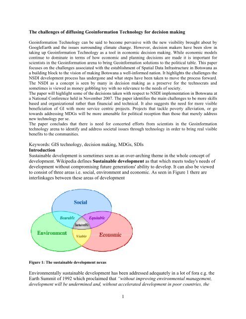
Sustainable development is sometimes seen as an over-arching theme in the whole concept <strong>of</strong><br />
development. Wikipedia defines Sustainable development as that which meets today's needs <strong>of</strong><br />
development without compromising future generations' ability to develop. It can also be viewed<br />
to consist <strong>of</strong> three areas i.e. social, environment and economic. As seen in Figure 1 there are<br />
interlinkages between these areas <strong>of</strong> development<br />
Figure 1: The sustainable development nexus<br />
Environmentally sustainable development has been addressed adequately in a lot <strong>of</strong> fora e.g. the<br />
Earth Summit <strong>of</strong> 1992 which proclaimed that “without improving environmental management,<br />
development will be undermined and, without accelerated development in poor countries, the<br />
1
environment will continue to degrade.” Indeed it might appear paradoxical that while we yearn<br />
for accelerated development we have to ensure that the environment is not harmed in the process.<br />
The basis <strong>of</strong> sustainable development, it can be shown, is information. Most <strong>of</strong> the development<br />
models use economic information as a basis to propose development. Examples <strong>of</strong> the most<br />
commonly used economic models are shown Table 1<br />
Table 1: Some Economic Models<br />
Economic model<br />
Comparative Advantage Economic theory predicts all countries gain if they specialise and trade<br />
the goods in which they have a comparative advantage. This is true even<br />
if one nation has an absolute advantage over another country.<br />
Rostow<br />
Harrod-Domar<br />
Lewis<br />
Dependency Theory<br />
This is a linear theory <strong>of</strong> development. Economies can be divided into<br />
primary secondary and tertiary sectors. The history <strong>of</strong> developed<br />
countries suggests a common pattern <strong>of</strong> structural change<br />
The Harrod-Domar model developed in the l930s suggests savings<br />
provide the funds which are borrowed for investment purposes.<br />
The Lewis model is a structural change model that explains how labour<br />
transfers in a dual economy. For Lewis growth <strong>of</strong> the industrial sector<br />
drives economic growth<br />
Dependency refers to over reliance on another nation. Dependency<br />
theory uses political and economic theory to explain how the process <strong>of</strong><br />
international trade and domestic development makes some LDC's ever<br />
more economically dependent on developed countries<br />
Balanced growth theory Balanced growth (or the big push) theory argues that as a large number<br />
<strong>of</strong> industries develop simultaneously, each generates a market for one<br />
another.<br />
Unbalanced growth<br />
theory<br />
Unbalanced growth theorists argue that sufficient resources cannot be<br />
mobilised by government to promote widespread, coordinated<br />
investments in all industries<br />
While these models are helpful in the development process they do not tell the whole picture<br />
regarding development as we have seen in Figure 1. The role <strong>of</strong> spatial information in the<br />
development nexus presented in the figure persuades one to think that more consideration needs<br />
to be brought to the political table when discussing development. It is recognized that institutions<br />
such as the World Bank have shown concern about environmentally sustainable development<br />
(ESD) and has financed a number <strong>of</strong> ESD projects in Sub-Saharan (World Bank, 1996).<br />
Concerns regarding climate change have brought to the fore a need for more information to<br />
perhaps curb the insatiable appetite for man to “develop” the earth at the expense <strong>of</strong> the social<br />
and environmental conditions. The desire to incorporate other types <strong>of</strong> information in the<br />
development agenda can help the world achieve sustainable development.<br />
2
NSDI and sustainable development<br />
One component <strong>of</strong> ensuring sustainable development is the establishment <strong>of</strong> National Spatial<br />
Data Infrastructures (SDI). According to the SDI cookbook (2000) SDIs are meant to be a<br />
collection <strong>of</strong> technologies, policies and institutional arrangements that facilitate the availability<br />
<strong>of</strong> and access to spatial data. The cookbook further states that the SDI provides a basis for spatial<br />
data discovery, evaluation, and application for users and providers within all levels <strong>of</strong><br />
government, the commercial sector, the non-pr<strong>of</strong>it sector, academia and by citizens in general.<br />
So if we start from the premise that sustainable development can only take place in an<br />
environment which has information we can see that an NSDI is an important component for<br />
development. Those in the geospatial pr<strong>of</strong>essions are sure about the importance <strong>of</strong> establishing<br />
SDI and perhaps do not need any convincing because that would be preaching to the converted.<br />
However even as we extol the virtues <strong>of</strong> an NSDI most <strong>of</strong> the African governments do not seem<br />
to give it the same kind <strong>of</strong> admiration as they do other more mundane infrastructures such as<br />
road networks, phone networks etc. Ezigbalike (2001) observed that the reasons for the lack <strong>of</strong><br />
support <strong>of</strong> SDI initiatives from the highest <strong>of</strong>fices might be<br />
• The lack <strong>of</strong> awareness <strong>of</strong> the value <strong>of</strong> SDI<br />
• Confusions surrounding the definition <strong>of</strong> SDI<br />
• Lack <strong>of</strong> policy and coordinating arrangements<br />
• The complexity <strong>of</strong> national issues such as the political, cultural, and economic positions<br />
<strong>of</strong> most countries<br />
The BOTSWANA NATIONAL SPATIAL DATA INFRASTRUCTURE<br />
In Botswana there has been considerable government support however on the implementation <strong>of</strong><br />
an NSDI and an <strong>of</strong>ficial launch was done in 2002. Tembo & Manisa (2003) report that after<br />
twists and turns the NSDI was successfully launched with the establishment <strong>of</strong> permanent<br />
working groups and a National GIS coordinating Committee (NGCC). Structurally the working<br />
groups are shown in Figure 3.<br />
According to Tembo & Manisa (2003) the functions <strong>of</strong> the<br />
working groups were as shown in Table 2:<br />
Table 2: Functions <strong>of</strong> working groups<br />
Working Group Functions<br />
Fundamental data • Analyse the need for fundamental datasets<br />
• Make specifications for the datasets<br />
• Put requirements for production, maintenance and updating<br />
routines <strong>of</strong> the fundamental datasets;<br />
• Disseminate information on fundamental datasets<br />
Standards • Analyse in what areas standards are needed for the NSDI<br />
• Find suitable standards and seek agreement about and promote the<br />
use <strong>of</strong> established standards;<br />
• Review established standards and propose any necessary changes<br />
or additions<br />
Metadata • Establish the metadata services<br />
• Monitor and support the development <strong>of</strong> metadata services<br />
• Promote and advertise the use <strong>of</strong> metadata services<br />
3
Institutional<br />
Framework<br />
Architecture and<br />
Infrastructure<br />
Education and Human<br />
Resources<br />
• Analyse how GI stakeholders should cooperate with government;<br />
• Analyse what responsibilities between stakeholders should be<br />
contained and assigned<br />
• Seek financing for the NGCC and its activities<br />
• Review the general performance <strong>of</strong> the NGCC and the NSDI<br />
initiative<br />
• Establish requirements on GI and GIS activities on institutional<br />
level<br />
• Develop guidelines for establishing GI and GIS infrastructure at<br />
institutional level;<br />
• Develop guidelines for GI and GIS maintenance.<br />
• Analyse the present GIS knowledge on different levels and in<br />
different GIS related positions, mainly in government<br />
organizations;<br />
• Review the existing GIS education and training courses provided<br />
by training institutions in Botswana<br />
• Analyse requirements on future staff needs <strong>of</strong> the NSDI.<br />
The launch also saw the establishment <strong>of</strong> website whose screen cut is shown in Figure 2<br />
http://www.ngis.gov.bw<br />
Figure 2: NSDI website<br />
4
Working Group<br />
Education and<br />
Training<br />
Working Group<br />
Standards<br />
Figure 3: Organisational structure <strong>of</strong> BNSDI<br />
Workging<br />
Group<br />
Fundamental<br />
Data<br />
NGCC<br />
Working Group<br />
Institutional<br />
Framework<br />
GIS<br />
COORDINATIO<br />
NUNIT<br />
Working Group<br />
Metadata<br />
Working Group<br />
Architecture and<br />
Infrastructure<br />
Current status<br />
The Working groups continued to meet and feed information to the National GIS coordinating<br />
Committee (NGCC) but, in truth, little was achieved in these working groups. Meetings were<br />
held to address the terms <strong>of</strong> references for each working group and to review progress on the<br />
mandates given to them but it appears that nothing was being achieved. While there was a lot <strong>of</strong><br />
zeal by most members initially it became apparent that there was need to address the issues<br />
surrounding skills in the working groups if the Infrastructure was indeed going to be achieved.<br />
Some <strong>of</strong> the participants in the NGCC, particularly the national mapping agency have developed<br />
national databases which form part <strong>of</strong> the identified fundamental datasets. Utility companies<br />
have, through private mapping companies, been collecting country wide village data at scales <strong>of</strong><br />
1:5000 with view <strong>of</strong> mapping theses villages for purposes <strong>of</strong> providing utility services to the<br />
villages. Tembo (2005) reports on the diffusion <strong>of</strong> GIS in the utility companies and highlights<br />
insufficiency <strong>of</strong> geospatial skills in the utility organizations. Manisa and Nkwae(2007) have<br />
shown the various GIS activities that have taken place in various government departments over<br />
the years in Botswana Some <strong>of</strong> these are the Tribal Land Integrated Management Systems, State<br />
5
Land Integrated Management Systems, National GeoScience Information Systems, and the<br />
Environment Support Programme. Others like the Department <strong>of</strong> Town and Regional Planning<br />
have set up a planning portal which would be used by the Planning Boards over the government<br />
intranet. A lot <strong>of</strong> money has been spent on all these projects. All these activities are supposed to<br />
feed into a National Spatial Data Infrastructure. The question to be asked is: is this happening?<br />
The answer is a resounding NO at the moment. While it can be said that most <strong>of</strong> the tools that are<br />
cited here go beyond data collection there still have to demonstrate beneficiation to the common<br />
man. Discussing the state <strong>of</strong> Environmental Information Systems in certain select African<br />
countries EIS-Africa in 2001 noted that most informations systems in the countries studied were<br />
planned on the basis <strong>of</strong> applying digital techniques such as remote sensing and/or GIS<br />
technologies for data acquisition, update, management and visualization. Botswana has perhaps<br />
moved slightly above data collection with the introduction <strong>of</strong> the new systems. However, when<br />
these are analysed against the ideals <strong>of</strong> an SDI we seem not have moved as envisaged. Vexing<br />
questions need to be asked as to what should really happen if we indeed are going to achieve a<br />
truly functioning SDI.<br />
Geoinformation conference recommendations<br />
At the Geoinformation conference held in November 2007 participants recommended among<br />
other things:<br />
• that there was need to strengthen the pr<strong>of</strong>essional association representing the geospatial<br />
information pr<strong>of</strong>essions.<br />
• That there was need to propose a geoinformation policy and coordination unit. This was<br />
to be done by establishing a drafting team which would work with a consultant<br />
• That government acquisition <strong>of</strong> GIS s<strong>of</strong>tware tools be done through enterprise<br />
agreements to realize economies <strong>of</strong> scales<br />
• That enhancement <strong>of</strong> skills at school, institutional, and national levels was required to<br />
enable GIS penetration to all <strong>of</strong> society<br />
Challenges <strong>of</strong> implementing NSDI<br />
NSDI ideals revolve on issues <strong>of</strong> coordination, technology, data and people.<br />
Data<br />
Data acquisition seems to be managed well at institutional level. However, other institutions are<br />
not normally availed information as to the accuracy, currency and standards used to collect these<br />
data sets that are “littered” all over the various institutions. Also as stated by Cavric &<br />
Ikgopoleng (2007) little effort has been spent on transforming data into information for decision<br />
making. The challenge is to ensure that data is discoverable so that individual institutions in the<br />
SDI do not have to collect this same information at tremendous cost. Data needs to move from<br />
the realm <strong>of</strong> data to information.<br />
Coordination<br />
The recommendation <strong>of</strong> the Geoinformation conference highlight the fact that there has been<br />
poor coordination <strong>of</strong> the NSDI effort as evidenced by the number <strong>of</strong> stand alone projects<br />
government is undertaking in the GIS area. Cavric, Ikgopoleng and Budic-Nedovic (2003) also<br />
observed that the majority <strong>of</strong> GIS users in Botswana were working in an uncoordinated manner,<br />
expressing no interests to co-operate and function on multiparticipant basis. They further state<br />
that the prevalent disharmonic approach and dispersion <strong>of</strong> technical and human resources is<br />
Botswana’s reality that restricts more beneficial outcomes from existing GIS capacities. The<br />
recommendation to establish a drafting team to consider holistically the issues <strong>of</strong> coordination<br />
can be seen in this light. Also, there is no current pr<strong>of</strong>essional oversight with respect to people<br />
6
who pretend to <strong>of</strong>fer services in the area <strong>of</strong> GIS. There exists the Botswana Surveying and<br />
Mapping <strong>Association</strong> whose focus seems to be on the surveying and mapping fraternity alone.<br />
In respect <strong>of</strong> coordination it is expected that institution arrangements need to be strengthened and<br />
that the current ad-hoc arrangements <strong>of</strong> working groups who do it on volunteer basis cannot be<br />
sustainable.<br />
Technology<br />
No doubt technology forms the backbone <strong>of</strong> all the activities in the SDI. The acquisition and<br />
maintenance <strong>of</strong> such technology is normally the mandate <strong>of</strong> the Department <strong>of</strong> Information and<br />
Technology within the government. Proposals for hardware and s<strong>of</strong>tware acquisition to enable<br />
effective e-government have been received well within government. It has been suggested that<br />
enterprise licencing arrangements be entered into between government and service providers so<br />
as to allow for economies <strong>of</strong> scale.<br />
People<br />
The greatest challenge in the successful implementation <strong>of</strong> any technology seems to be people.<br />
While new solutions are being proposed there sometimes is lesser investment in the people who<br />
should run those systems. One observes that most <strong>of</strong> the systems that have been or are in the<br />
process <strong>of</strong> being implemented are based on a champion in the organization. In the event that the<br />
champion leaves that organization there is little doubt that the system would face major<br />
challenges and sometimes could become redundant.<br />
In the organization <strong>of</strong> coordination one observes that little has been done to set up a proper<br />
coordinating unit with capable personnel to run the unit. This leaves the whole organization <strong>of</strong><br />
SDI at the mercy <strong>of</strong> personal interest rather the common good. The human resource factor at this<br />
level therefore needs to be addressed adequately because without a proper driver the whole NSDI<br />
implementation seems to be going round in circles.<br />
The cook book <strong>of</strong>fers solutions regarding the organizational issues surrounding the SDI by<br />
proposing that the following should be done while building an SDI<br />
• Build a consensus process: build on common interests and create a common vision<br />
• Clarify the scope and status <strong>of</strong> the SDI<br />
• Exchange best practices locally, regionally and globally<br />
• Consider the role <strong>of</strong> management in capacity development<br />
• Consider funding and donor involvement<br />
• Establish broad and pervasive partnerships across private and public sectors<br />
• Develop clearinghouses and use open international standards for data and<br />
technology<br />
Management needs to seriously address the issue <strong>of</strong> capacity building especially that <strong>of</strong> human<br />
resources to enable full participation <strong>of</strong> individuals in the working groups so that the mandate <strong>of</strong><br />
the working groups can indeed be effected.<br />
SDI and funding models<br />
Implementation <strong>of</strong> an SDI will necessitate funding. While this paper argues that money seems<br />
not to be the biggest problem in the establishment and continual implementation <strong>of</strong> an NSDI it<br />
nonetheless plays a major part in the way SDI can and will continue to exist past the “project”<br />
phase. Rhind(2000) established that there were four different models existing on SDI funding:<br />
1. Government Funding (Funds derived from taxation);<br />
2. Private Sector Funding (Derived from fees charged to customers);<br />
3. Public Sector Funding (Derived from fees charged to customers); and<br />
7
4. The Indirect Method (Funds derived from advertising, sponsorship and other indirect<br />
methods).<br />
These funding models need not work in isolation. In the case <strong>of</strong> Botswana the current funding<br />
model revolves around direct government funding through taxation and public sector funding<br />
through cost recovery by charging users.<br />
Giff & Coleman (2002) highlight the key factors associated to the funding models state that the<br />
design and usage <strong>of</strong> funding models are affected by a number <strong>of</strong> issues associated with the SDI<br />
implementation environment. Some <strong>of</strong> the most significant factors are:<br />
• Government Structure - The level <strong>of</strong> government responsible for SDI implementation;<br />
• Government Policies – SDI classification (Classic Infrastructure [public good] or<br />
• Network Infrastructure [capacity based]), is there a need for earn returns on investment?<br />
• Capital market – The availability <strong>of</strong> local capital for investment ;<br />
• Social and Political Culture – The society’s views on infrastructure financing;<br />
• Private Sector Activities- The level <strong>of</strong> private sector involvement in SDI<br />
implementation;<br />
• and<br />
• Legislation – The different laws that affects infrastructure financing in general and SDI<br />
pricing policies.<br />
They conclude that for developing countries the best funding model should have the following<br />
components<br />
8
Figure 4: Funding models (After Giff & Coleman)<br />
We can learn from this that much needs to be done in respect <strong>of</strong> creating the enabling<br />
environment in which the private sector can participate in the SDI. The need to create partnership<br />
between private sector and government has not fully been explored, for instance. Partly, this is<br />
because the size <strong>of</strong> the geospatial private sector is almost insignificant in Botswana. However<br />
overtures have been made by some private sector companies who see their role in both<br />
application and data development. Private sector companies in Botswana have been involved in<br />
developing applications for government as well as collecting data. Private sector companies cited<br />
areas in which they could participate in the SDI as:<br />
► Standards based data development<br />
► Service provision and support for data management<br />
► Contributing to the development <strong>of</strong> the SDI elements ie. Discovery and access<br />
mechanisms (Portals)<br />
► Skills development<br />
9
Way forward<br />
While all these issues talk to the arrangements <strong>of</strong> a<br />
proper SDI the challenge still remains on beneficiation<br />
<strong>of</strong> the SDI to sustainable development. The much talked<br />
about think globally, act locally comes to mind here.<br />
How can we think “big” and bring local solutions to<br />
bear in our SDI? One <strong>of</strong> the millennium goals states that<br />
“ In cooperation with the private sector, make available<br />
the benefits <strong>of</strong> new technologies, especially information<br />
and communications”. One sees the role <strong>of</strong> SDI as that<br />
<strong>of</strong> providing information services to the betterment <strong>of</strong><br />
society. SDI must now move from the current teething<br />
problems <strong>of</strong> institutional arrangement to the actual<br />
solution provision in issues <strong>of</strong> poverty alleviation. It is<br />
proposed that SDIs be aligned to the United Nations<br />
declaration <strong>of</strong> the MDGs. In this respect it is proposed<br />
for example to set up programmes that address the<br />
MDGs in a systemic manner. See Side bar.<br />
It is the responsibility <strong>of</strong> geospatial technologist to bring<br />
beneficiation to the communities by proposing solutions<br />
on how MDGs will be addressed within the SDI<br />
environment.<br />
References<br />
MDG Goal 1 and SDI<br />
Halving the population <strong>of</strong> the people<br />
who earn less than a dollar and suffer<br />
from hunger by the 2015-The<br />
contribution <strong>of</strong> SDIs.<br />
It is proposed that SDI’s will collect<br />
information and set up systems that<br />
inform the political process in terms <strong>of</strong><br />
the number <strong>of</strong> people who are still<br />
earning a dollar a day in any particular<br />
jurisdiction. Further all those who are<br />
deemed to suffer from hunger should<br />
have their information collected in<br />
databases created for this purpose.<br />
This requires working with Statistical<br />
Offices and Mapping Agencies and<br />
private sector geospatial organizations.<br />
The information so collected could<br />
then be used to plan mitigation<br />
measures and halve the number <strong>of</strong> the<br />
poor by the targeted date.<br />
1. Cavric, B., Budic-Nedovic, Z. and Ikgopoleng G. H. “Diffusion <strong>of</strong> GIS Technology in<br />
Botswana: process and determinants”, International Development Planning Review, Vol.<br />
25, No. 2, pp. 195-219, 2003<br />
2. Definition <strong>of</strong> sustainable development from<br />
http://en.wikipedia.org/wiki/Sustainable_development accessed 1st March 2008<br />
3. Ezigbalike, I.C. “The future orientation <strong>of</strong> Geographic Information Systems (GIS) in Africa”<br />
Economic Commission For Africa – ECA, Development Information Services Division,<br />
Geo-information Team, pp. 1-30, http://www.uneca.org/publications.htm, 2000.<br />
4. Garfield G. and David C. “Spatial Data Infrastructure Funding Models: A necessity for<br />
the success <strong>of</strong> SDIs in Emerging Countries”, proceedings <strong>of</strong> the XXII FIG International<br />
Congress, Washington DC, April 19-22, 2002<br />
5. Manisa M. and Nkwae B. (2007). “ Towards the development <strong>of</strong> the Botswana Spatial Data<br />
Infrastructure” Proceedings <strong>of</strong> FIG working work, May 13-17, Hong Kong, China<br />
New York, NY. Pp39-55<br />
6. Rhind, D. (2000) “Funding an NGDI.” In Geospatial Data Infrastructure Concepts,<br />
Cases and Good Practice, Ed R. Groot and J. McLaughlin. Oxford University Press,<br />
10
7. Tembo and Manisa (2003), “New Developments in the Establishment <strong>of</strong> the Botswana<br />
National Spatial Data Infrastructure”, Proceeding <strong>of</strong> the FIG Working Week, Paris France<br />
8. United Nations. 1992. Agenda 21. United Nations Conference on Environment and<br />
Development (UNCED), Rio de Janeiro, Brazil. June 3-14, 1992. Conches, Switzerland<br />
9. United Nations. 2005. In larger freedom: towards development, security and human<br />
rights for all, UN HQ, New York, USA<br />
10. World Bank. 1996. Toward Environmentally Sustainable Development in Sub-Saharan<br />
Africa- A World Bank Agenda. World Bank publication. Washington D.C. USA<br />
11