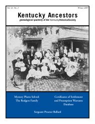
Kentucky Ancestors, Volume 44, Number 2 - Kentucky Historical ...
Kentucky Ancestors, Volume 44, Number 2 - Kentucky Historical ...
Kentucky Ancestors, Volume 44, Number 2 - Kentucky Historical ...

You also want an ePaper? Increase the reach of your titles
YUMPU automatically turns print PDFs into web optimized ePapers that Google loves.
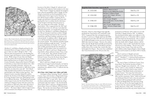
Figure 3. Map of Logan County, Ky., with the #1 indicator pointing to<br />
the location of the J. S. Baugh family home (where he lived in 1877).<br />
Map of western Simpson County, Ky., with the #2 indicator pointing to<br />
the location of the James Bowie family land (formerly Logan County at<br />
the time of Jim Bowie’s birth).<br />
Abraham G. and Rebecca Baugh purchased in the<br />
Schochoh District of Logan County in 1849 and<br />
gave to their son, John S. Baugh in 1867. 50 This<br />
100-acre farm was located next to the dividing line<br />
between Logan and Simpson counties along Terrapin<br />
Creek. While trying to locate where the Baughs<br />
lived, the authors discovered that the famous James<br />
Bowie had been born on 10 April 1796 in Logan<br />
County, <strong>Kentucky</strong>, along another branch of Terrapin<br />
Creek where it crosses Turnertown Road, nine miles<br />
northwest of Franklin, <strong>Kentucky</strong>. However, the<br />
Bowie family had left <strong>Kentucky</strong> in 1800 when young<br />
Jim Bowie was about four years old. 51 By 6 March<br />
1836, Jim Bowie had traveled to San Antonio, Texas,<br />
and had died at the Alamo at about age forty. The<br />
Simpson County researchers helped the authors<br />
pinpoint the locations of the Baugh and Bowie lands<br />
by tracing Terrapin Creek (now called Spring Creek)<br />
in two different directions. The Baugh land remained<br />
within Logan County, but the former Bowie land<br />
ended up in Simpson County when the county line<br />
was redrawn in 1869 and a three-mile wide strip of<br />
land from Logan County became part of Simpson<br />
County. 52 The map in Figure 3 shows Logan County<br />
with an extension into Simpson County with the<br />
62<br />
| <strong>Kentucky</strong> <strong>Ancestors</strong><br />
locations of the John S. Baugh (#1 indicator) and<br />
James Bowie (#2 indicator) lands marked on the map.<br />
When Verner S. Baugh was asked by his daughter,<br />
Janet, about his grandfather, John S. Baugh, the first<br />
thing he mentioned was that his grandfather was a<br />
wealthy farmer from Logan County, <strong>Kentucky</strong>. So<br />
how did he become wealthy? It appears that he<br />
bought and sold land in <strong>Kentucky</strong> and Texas with<br />
good profits, but it is evident that his inheritance<br />
of the Terrapin Creek farm from his parents in<br />
1867 was a large part of his wealth. (See land<br />
deeds below.) Also, it appeared that the 1867 land<br />
deed itself was in lieu of a will since it provided the<br />
following information: In consideration of their love<br />
for their son, Abraham G. and Rebecca Baugh gave<br />
the 100-acre Terrapin Creek farm to John S. Baugh<br />
in return for living in his home for the rest of their<br />
natural lives, plus food, clothing, medical care, and<br />
a decent burial. In addition, John S. Baugh agreed<br />
not to sell the land before his parents died without<br />
the consent of both. Then Abraham and John signed<br />
the deed and Rebecca made her mark. 53 So when<br />
his parents died before 22 October 1877, most of<br />
their worldly goods had already been distributed.<br />
Therefore, after his father’s estate was settled on 22<br />
October 1877, John S. and Lucy J. Baugh moved<br />
their family to Bono, Johnson County, Texas, in late<br />
1877 or early 1878. They sold the Terrapin Creek<br />
property on 23 March 1878, after they moved to<br />
Johnson County, Texas, but the buyer, James Rogers,<br />
was in Logan County, <strong>Kentucky</strong>, at the time he<br />
signed the land deed. 54<br />
John S. and Lucy J. Baugh’s real estate<br />
transactions in Logan County, <strong>Kentucky</strong>, are listed in<br />
the chart below. 55 (<strong>Number</strong>s 1 and 2 represent land<br />
acquisitions; the addition of the “S” indicates that the<br />
land was sold.)<br />
Life in Texas: John S. Baugh, Lucy J. Gillum, and Family<br />
Life began in Bono (meaning “friend”), Johnson<br />
County, Texas, with the John S. Baugh family being<br />
credited with being one of the first families to settle<br />
in Bono in late 1877 or early 1878. Also, in 1878,<br />
the Bono residents built the first school out of logs<br />
and boards made from timber. 56 Per the land deeds<br />
shown below, John S. and Lucy J. Baugh purchased<br />
land in Bono, Texas on 6 February 1878 from James<br />
Rogers. This was the same James Rogers who bought<br />
their Terrapin Creek property in Logan County,<br />
From <strong>Kentucky</strong> Roots to Texas Homesteads , continued<br />
Baugh Real Estate Transactions, Logan County, KY.<br />
Edward C. Watson to John S.<br />
#1. 24 Oct 1865<br />
Baugh, 56 acres, Muddy River, $1,456<br />
Abraham G. & Rebecca Baugh<br />
#2. 14 Oct 1867<br />
gave to John S. Baugh, 100 acres,<br />
Terrapin Creek<br />
John S. & Lucy J. Baugh to<br />
1S. 25 Nov 1871<br />
Benjamin McLemore, 56 acres, Muddy<br />
River, $1,699<br />
John S. & Lucy J. Baugh to James<br />
2S. 23 Mar 1878<br />
Rogers, 100 acres, Terrapin Creek,<br />
$1,600<br />
<strong>Kentucky</strong>. However, James Rogers had originally<br />
purchased the Texas land in 1873 and held it until<br />
1878. It appeared that they exchanged properties,<br />
but John S. and Lucy J. Baugh ended up with $800<br />
in their pocket since they sold 100 acres in <strong>Kentucky</strong><br />
for $1,600 and bought seventy-one acres in Texas for<br />
$800 where land was cheaper. However, the authors<br />
believe that the Baugh family probably purchased the<br />
Rogers’ land “sight unseen” and decided to purchase<br />
another farm to live on after they viewed what they<br />
had bought from Rogers. They must have established<br />
their Texas homestead on the 160 acres that they<br />
Figure 4. Plat map of Johnson County, Tx., about 1880 (with indicators<br />
#1 - #5 pointing to the locations of the J. S. Baugh land purchases).<br />
The #3 indicator points to the location of the J. S. Baugh family home<br />
at Bono, Tx., which is seven miles west of Cleburne, Tx.<br />
Book 39, p. 319<br />
Book 41, p. 191<br />
Book 45, p. 329<br />
Book 74, p. 617<br />
purchased on 8 February 1878, which was not sold<br />
until John S. Baugh retired in 1907. In addition,<br />
they purchased another eighty acres (adjacent to the<br />
original 160 acres) on 17 December 1883 to expand<br />
their farm land near the homestead. Also, to repeat<br />
the pattern of passing the family farm to the heirs<br />
before his death, John S. Baugh, widower, sold his<br />
land in Bono, Texas in 1907 and divided the money<br />
with all seven of his children. Then he went to live<br />
in Snyder, Scurry County, Texas with one of his<br />
older children (either Eugene Baugh or Nettie Baugh<br />
Wasson) until his death on 26 March 1909 in Snyder,<br />
Texas.<br />
John S. and Lucy J. Baugh’s real estate<br />
transactions in Johnson County, Texas are listed<br />
below. 57 (<strong>Number</strong>s 1 – 5 represent land acquisitions;<br />
the addition of the “S” indicates that the land was<br />
sold.)<br />
The map in Figure 4 of Johnson County, Texas<br />
shows Bono, Texas and the locations of John S.<br />
and Lucy J. Baugh’s tracts of land (#1 - #5). In the<br />
1870s, “Calvin L. Jones and Ben H. Williamson<br />
were the first permanent settlers in this vicinity,”<br />
according to Viola Block’s book on the history of<br />
Johnson County. 58 She wrote that Calvin Jones<br />
established the town in 1877 and named the post<br />
office and the community “Bono,” which was located<br />
near Robinson’s Branch Creek to the east and seven<br />
miles from Cleburne going generally eastward. 59<br />
In 1890, the Baugh family must have been living<br />
on the 160 acres (#3 on the map) bought from E.<br />
J. Parent when the cyclone (tornado) hit Bono on<br />
Sunday afternoon, 4 May 1890. Fortunately, the<br />
Baugh family survived with only minor injuries since<br />
Winter 2008 | 63