

Download - Coordinates
Download - Coordinates
Download - Coordinates

You also want an ePaper? Increase the reach of your titles
YUMPU automatically turns print PDFs into web optimized ePapers that Google loves.
The study area, Port Harcourt lies<br />
between latitude: 4°45’ and 5°02’N and<br />
between longitude: 6°52E and 7°09’E.<br />
Since suffi cient data were available to<br />
implement Equation 1.1, it is possible to<br />
derive a mathematical model such that,<br />
with GPS observation, we should be<br />
able to compute the geoidal undulation<br />
using any regression method, provided<br />
it satisfi es certain statistical criteria<br />
regarding the data and determining the<br />
best fi t to the observations (Younger;<br />
1985). In this case, the least squares<br />
approach was used to fi nd the best curve,<br />
that is, the one which is on average<br />
closest to all points, since blunders<br />
in the observations were removed.<br />
As a way of checking for arithmetic<br />
errors or blunders, the values of the<br />
coeffi cients were substituted into the<br />
original model and both equations must<br />
check. Problems were experienced with<br />
regard to the number of decimal places<br />
carried causing rounding errors. The<br />
new models combined the accuracy<br />
of orthometric height and ease of<br />
ellipsoidal height in geoid determination<br />
to develop the ‘Satlevel’ model.<br />
‘Satlevel’ method of<br />
geoid determination<br />
Satlevel method of geoid determination<br />
involves the use of both ellipsoidal<br />
and orthometric heights to develop a<br />
mathematical algorithm to determine<br />
the geoid. The methodology involves<br />
acquisition of data relating to<br />
ellipsoidal and orthometric heights,<br />
formulating the problems to develop<br />
the model and analysis of results.<br />
Field Operations<br />
The fi eld operations were carried out for<br />
the purposes of acquiring the ellipsoidal<br />
heights and orthometric heights for a<br />
number of well distributed points in<br />
the study area. Both spirit levelling and<br />
GPS fi eld exercises were carried out.<br />
Spirit levelling<br />
Every survey job must be planned to<br />
attain certain accuracy. In this research,<br />
fi rst order accuracy was planned and<br />
achieved in geodetic levelling. (Davis<br />
et al, 1981; SURCON, 2003).<br />
GPS observation<br />
Methodology of Differential Global<br />
Positioning System (DGPS) as given<br />
by Trimble (2007) was adopted. DGPS<br />
observations were made at the most<br />
suitable locations along the levelling<br />
routes using a dual frequency GPS<br />
receiver (Trimble 4700). The results of<br />
the fi eld operation were processed and<br />
used for the mathematical modelling.<br />
Mathematical model<br />
Physical evidence of the views of<br />
the surface of the earth supports the<br />
hypothesis that the totality of geoidal<br />
undulation at a geographic location<br />
is composed of two parts, namely:<br />
1) the constant part throughout<br />
the study area N m = X 0<br />
(independent of position) and<br />
2) the changing part N c = f(φ, λ) which<br />
depends on changes in geographic<br />
location within the study area.<br />
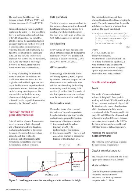
Mean Sea Level<br />
N = N m + N c (2.1)<br />
Direction<br />
of gravity<br />
Figure 3: Levelling procedure for acquiring data for orthometric height<br />
24 | <strong>Coordinates</strong> August 2012<br />
H<br />
The statistical signifi cance of these<br />
relationships is considered in developing the<br />
model. The model assumed that the geoidal<br />
undulation is a function of geographical<br />
location. The model was derived<br />
Where:<br />
x 1, x 2, x 3 , x 4 and x 5 are the<br />
unknown parameters.<br />
All other terms as earlier defi ned.The<br />
set of base functions for Equation 2.2<br />
were determined and the unknown<br />
parameters were estimated using least<br />
squares adjustment since suffi cient<br />
observation point were available.<br />
Results and analysis<br />
Result<br />
(2.2)<br />
The results of data acquisition of<br />
orthometric height (H) from geodetic<br />
levelling and that of GPS ellipsoidal heights<br />
(h) are presented as shown in fi gure 1. On<br />
the Y-axis are the values of undulations<br />
while X-axis contained the numbers<br />
given to each of the 76 points used for the<br />
study. Dh and DH are the ellipsoidal and<br />
orthometric heights differences between<br />
successive points respectivelly. DIFF is<br />
the height differences between Dh and<br />
DH Other terms as defi ned previuosly.<br />
Assessing the parametric<br />
model performance<br />
The following tests were used to assess<br />
the performance of parametric<br />
Classical empirical approach<br />
The residuals were computed. The mean<br />
square error obtained was 0.134mm<br />
Model validation<br />
Data for fi ve points were randomly<br />
selected as checks for model<br />
validation. The mean square error<br />
computed to be 0.159mm


