24.3 Solar Energy and Winds
24.3 Solar Energy and Winds
24.3 Solar Energy and Winds

You also want an ePaper? Increase the reach of your titles
YUMPU automatically turns print PDFs into web optimized ePapers that Google loves.
Section <strong>24.3</strong> (continued)<br />
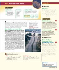
Global <strong>Winds</strong><br />
Use Visuals<br />
Figure 13 Identify 0, 30 S, 60 S,<br />
30 N, <strong>and</strong> 60 N. Explain that the global<br />
wind patterns shown in this figure remain<br />
fairly constant throughout the year,<br />
though the change of seasons does have<br />
some effect on the circulation of the<br />
atmosphere. Heating patterns change as<br />
the seasons change, <strong>and</strong> patterns of air<br />
pressure (<strong>and</strong> thus wind) change as a<br />
result. Point out that convection cells are<br />
vertical <strong>and</strong> reach to the top of the<br />
troposphere. Point to the convection cell<br />
between 0 <strong>and</strong> 30 S <strong>and</strong> ask, Which<br />
direction is this wind pattern felt on<br />
the ground? (Northwest) In which<br />
regions of Earth are the global winds<br />
moving generally from the east in a<br />
westerly direction? (0°–30° N, 0°–30° S,<br />
60° N–90° N, <strong>and</strong> 60° S–90° S) Why are<br />
the arrows in the 0–30 S region (over<br />
South America) curving to the left? (The<br />
northerly winds curve westward as the result<br />
of Earth’s rotation—or the Coriolis effect.)<br />
This figure can be used to help explain<br />
the movements of fronts <strong>and</strong> storms in<br />
Section 24.5 <strong>and</strong> global climate patterns<br />
in Section 24.7. Visual<br />
Convection Cells<br />
758 Chapter 24<br />
L1<br />
L2<br />
Purpose Students observe a convection<br />
cell produced in water.<br />
Materials 1-L beaker, water, hot plate<br />
or Bunsen burner, 5–10 drops of food<br />
coloring<br />
Procedure Fill the beaker with<br />
approximately 750 mL water. Place the<br />
beaker on a hot plate or Bunsen burner<br />
<strong>and</strong> heat water until some steam is rising,<br />
but before boiling. Turn off the heat<br />
source. Explain that convection cells are<br />
common phenomena in both air <strong>and</strong><br />
water on many scales, from global to<br />
local winds, <strong>and</strong> from ocean currents to<br />
coffee cups. Slowly add the drops of food<br />
coloring (they will spread quickly, so only<br />
add enough to make the convection cell<br />
visible). Ask students to explain what is<br />
causing the convection cell.<br />
Expected Outcome The food coloring<br />
will reveal the circulation of water in a<br />
convection cell before dissipating. This<br />
cell is produced when warm water<br />
touches surface air, cools, <strong>and</strong> sinks again<br />
to the bottom. Visual, Logical<br />
Warm air rises<br />
at the equator until<br />
it reaches the top<br />
of the troposphere.<br />
The circulating<br />
air patterns<br />
are called<br />
“convection cells.”<br />
Figure 13 Earth is surrounded by<br />
a set of global wind belts.<br />
Figure 14 For hundreds of years,<br />
sailing ships have relied on global<br />
winds to transport cargo across<br />
the oceans.<br />
Interpreting Visuals Which<br />
b<strong>and</strong> of global winds would a<br />
sailing ship use to move cargo<br />
from Canada to Europe?<br />
758<br />
Facts <strong>and</strong> Figures<br />
Dry air sinks<br />
over the world’s<br />
deserts.<br />
Where the Wind Dies While trade winds<br />
<strong>and</strong> westerlies occur where convection cells<br />
blow across the surface, there are also areas<br />
where the wind dies out. These occur where<br />
the convection cells produce areas of rising or<br />
sinking air, such as at the equator, at 30 north<br />
<strong>and</strong> south latitude, <strong>and</strong> at 60 north <strong>and</strong> south<br />
latitude. The area of low winds at the equator<br />
is referred to as the doldrums, <strong>and</strong> the low<br />
Trade winds<br />
Westerlies<br />
Westerlies<br />
Earth’s rotation<br />
Doldrums<br />
Trade winds<br />
Polar easterlies<br />
Very cold air sinks<br />
at the poles <strong>and</strong> flows<br />
outward, creating winds<br />
called polar easterlies.<br />
The area where<br />
the trade winds<br />
die out is known<br />
as the doldrums.<br />
Global <strong>Winds</strong><br />
<strong>Winds</strong> that blow over long distances from a specific direction are<br />
called global winds. These winds are part of a worldwide pattern of<br />
air circulation. Global winds are caused by the unequal heating of<br />
Earth’s surface across a large region.<br />
Convection Cells Global winds move in a series of huge b<strong>and</strong>s<br />
called convection cells. As you can see in Figure 13, these b<strong>and</strong>s look<br />
like loops from the side. These b<strong>and</strong>s are caused by temperature variations<br />
across Earth’s surface. At the equator, for example, temperatures<br />
tend to be warmer than at other latitudes. Warm air rises at the equator,<br />
creating a low-pressure region. This warm air is replaced by cooler<br />
air brought by global winds blowing near the surface. Higher in the<br />
atmosphere, air blows away from the equator toward the poles. Similar<br />
convection cells cover large b<strong>and</strong>s of latitude across Earth.<br />
The trade winds are wind belts just north <strong>and</strong> south of the equator.<br />
In the Northern Hemisphere, they blow from the northeast to the southwest.<br />
The prevailing westerlies occur between 30° <strong>and</strong> 60° latitude in<br />
both hemispheres. These winds generally blow from west to east over<br />
much of North America. The polar easterlies extend from 60° latitude to<br />
the poles in both hemispheres. Trade winds, westerlies, <strong>and</strong> polar<br />
easterlies are examples of global winds.<br />
wind regions at 30 north <strong>and</strong> south latitude<br />
are called the horse latitudes. This name has<br />
a gruesome historical origin. Colonial sailors<br />
traversing the Atlantic would frequently get<br />
stuck around 30 N when the wind died. To<br />
survive at sea with a limited supply of fresh<br />
water on board (<strong>and</strong> to lighten the ship’s<br />
weight) the sailors would throw a few horses