Cooperative Robot Teleoperation through Virtual Reality ... - VW
Cooperative Robot Teleoperation through Virtual Reality ... - VW
Cooperative Robot Teleoperation through Virtual Reality ... - VW

You also want an ePaper? Increase the reach of your titles
YUMPU automatically turns print PDFs into web optimized ePapers that Google loves.
) Obstacle Detection: Presentation of possible<br />
obstacles in the working trajectory directly in the<br />
image would be a useful feature, especially for<br />
new users.<br />
c) Tracking Route: Tracking activities would be<br />
better performed if the trajectory to be tracked<br />
were highlighted. In an automatic system, one can<br />
rely on the tracking algorithm; in some cases<br />
tracking is related to an inspection task -checking<br />
the status of underwater pipelines or<br />
communication lines.<br />
d) Reference Information about Other Users: In a<br />
collaborative environment where other users are<br />
performing other activities, the presence and<br />
activities of all concerned should be clearly<br />
described to everyone both to facilitate<br />
communication and prevent misunderstanding.<br />
e) Data Fusion. Information from multiple sensors<br />
like (sonar system, thermal image, and even the<br />
laser system) might be integrated in a single<br />
picture, showing the relevance of each information<br />
to the user. In some cases, multiple images in<br />
different windows may provide clues for specific<br />
tasks.<br />
f) Communication Latency. Working with<br />
teleoperated system involves in some cases to<br />
work with delayed data, but when a collaborative<br />
group is considered, the latency worsen the<br />
communication (and robots’ controllability) among<br />
the team and the robots. Information<br />
synchronization should be planned in the data<br />
exchange.<br />
4.3. <strong>Virtual</strong> <strong>Reality</strong> Issues<br />
a) Natural Landmarks: Certain natural landmarks<br />
are easily utilized as references for certain<br />
activities; not every underwater boulder, however,<br />
can be used to signal a specific point. Users must<br />
choose this option sparingly, considering other<br />
possible options in their immediate environment,<br />
and better yet, decide with the entire team about<br />
what would be the landmarks to be used.<br />
b) <strong>Virtual</strong> Route: <strong>Virtual</strong> reality allows the interface<br />
to highlight specific sections with pale colors<br />
(transparent information), offering a clear and<br />
unmistakable path to the target. Obviously, the<br />
task must permit this feature: in the case of a<br />
random searching task, there is no route to<br />
illuminate.<br />
c) Special Marks: Objects floating about in a virtual<br />
world have to provide additional information to the<br />
users. Imagine, for example, an object floating in<br />
the middle of a hall: what is its real position in<br />
relation to the ceiling? Since some users have<br />
difficulty with spatial problems, an additional<br />
object must be presented to simplify such inquiries.<br />
Our solution? <strong>Virtual</strong> shadow projection on both<br />
the surface and the bottom of the sea.<br />
d) <strong>Virtual</strong> – <strong>Reality</strong> Synchronization. Objects in the<br />
virtual world must be synchronized with the one in<br />
the real world, to provide a meaning interaction.<br />
Communication latency should be taken in account<br />
to avoid data misinterpretation.<br />
4.4. KISS: Keep it Simple and Short<br />
Useless data can quickly clutter the user’s screen.<br />
It is certainly tempting to present everything in every<br />
possible format. The data is there anyway, so why be<br />
stingy –or discriminating- with it? First of all,<br />
because distract the user. Nevertheless, there are other<br />
reasons as well:<br />
a) The more unnecessary data on the screen, the less<br />
space available for important data.<br />
b) Multiple formats, like alphanumerical data, can be<br />
hard to digest at critical moments.<br />
c) Excess information requires a good amount of time<br />
to understand and to use the interface correctly.<br />
d) If an element or graphic in the interface does not<br />
communicate anything meaning or significant, then<br />
delete it!<br />
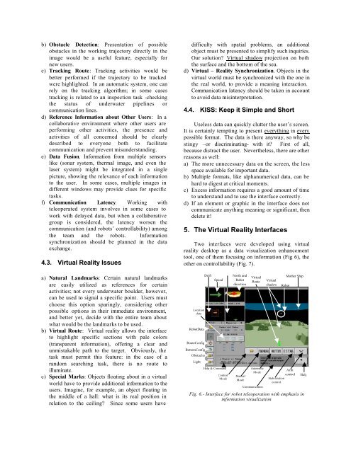
5. The <strong>Virtual</strong> <strong>Reality</strong> Interfaces<br />
Two interfaces were developed using virtual<br />
reality desktop as a data visualization enhancement<br />
tool, one of them focusing on information (Fig 6), the<br />
other on controllability (Fig. 7).<br />
Location<br />
data<br />
<strong>Robot</strong>Data<br />
RouteConfig<br />
BottomConfig<br />
Obstacles<br />
Light<br />
Drift<br />
Speed<br />
Help & Command<br />
Control<br />
Mode<br />
North and<br />
<strong>Robot</strong><br />
direction<br />
Manual<br />
Mode<br />
<strong>Virtual</strong><br />
Route<br />
Automatic<br />
Mode<br />
Communication<br />
<strong>Virtual</strong><br />
shadow<br />
Stabilization<br />
control<br />
<strong>Robot</strong><br />
Mother Ship<br />
Arm<br />
control Help<br />
Fig. 6.- Interface for robot teleoperation with emphasis in<br />
information visualization