Moffat Collection System Project - Mitigation Plan 6-9-11 - Colorado ...
Moffat Collection System Project - Mitigation Plan 6-9-11 - Colorado ...
Moffat Collection System Project - Mitigation Plan 6-9-11 - Colorado ...

Create successful ePaper yourself
Turn your PDF publications into a flip-book with our unique Google optimized e-Paper software.
Proposed <strong>Mitigation</strong> for the <strong>Moffat</strong> <strong>Collection</strong> <strong>System</strong> <strong>Project</strong> 06/09/20<strong>11</strong><br />
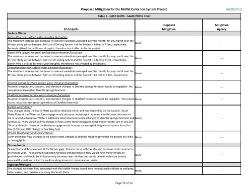
Table 7 - EAST SLOPE - South Platte River<br />
Proposed<br />
<strong>Mitigation</strong><br />
EIS Impacts<br />
Surface Water<br />
Antero Reservoir surface water elevation fluctuation :<br />
The maximum increase and decrease in reservoir elevation (averaged over the month) for any month over the<br />
45-year study period between Full Use of Existing <strong>System</strong> and the <strong>Project</strong> is 9 feet to 7 feet, respectively.<br />
Antero is utilized for multi-year droughts, therefore is not affected by the project.<br />
None ---<br />
Eleven Mile Canyon Reservoir surface water elevation fluctuation :<br />
The maximum increase and decrease in reservoir elevation (averaged over the month) for any month over the<br />
45-year study period between Full Use of Existing <strong>System</strong> and the <strong>Project</strong> is 4 feet to 3 feet, respectively.<br />
Eleven Mile is utilized for multi-year droughts, therefore is not affected by the project.<br />
Cheesman Reservoir surface water elevation fluctuation :<br />
The maximum increase and decrease in reservoir elevation (averaged over the month) for any month over the<br />
45-year study period between Full Use of Existing <strong>System</strong> and the <strong>Project</strong> is 61 feet to 6 feet, respectively.<br />
Strontia Springs Reservoir surface water elevation fluctuation :<br />
Reservoir evaporation, contents, and elevation changes to Strontia Springs Reservoir would be negligible. No<br />
recreation is allowed on Strontia Springs Reservoir.<br />
<strong>Mitigation</strong><br />
Agency<br />
None ---<br />
None ---<br />
None ---<br />
Chatfield Reservoir surface water elevation fluctuation :<br />
Reservoir evaporation, contents, and elevation changes to Chatfield Reservoir would be negligible. The project None --has<br />
no impact on storage or operations of Chatfield Reservoir.<br />
Surface water flows :<br />
Flow changes along the South Platte would be relatively minor and vary depending on the location. South<br />
Platte flows at the Waterton Canyon gage would decrease on average in summer months (max. decrease of<br />
5% in June) due to Denver Water's additional direct diversions and exchanges to Strontia Springs Reservoir and<br />
Conduit 20. There would be little change in flows at the Waterton gage in most winter months (1% in Dec and<br />
0% in Jan-March). Flows at the Henderson gage would increase on average during winter months from Oct-<br />
Nov (2-9%) and little change in flow May-Sept.<br />
Stream Morphology and Sedimentation :<br />
Given the minor flow changes to the South Platte, impacts to channel morphology under the project are likely<br />
to be negligible.<br />
Groundwater<br />
Below Chatfield Reservoir and at the Denver gage, flows increase in the winter and decrease in late summer in<br />
an average year. The maximum expected increases and decreases in flow would have minor effects on<br />
groundwater and would be limited to only the areas near the river and would be well within the normal<br />
seasonal fluctuations typical for aquifers along streams in mountainous terrain.<br />
Riparian/Wetland<br />
The changes in stream flow associated with the <strong>Moffat</strong> <strong>Project</strong> would have no measurable effects to wetlands,<br />
other waters, and riparian area along the South Platte.<br />
Page 13 of 14<br />
None ---<br />
None ---<br />
None ---<br />
None ---