IC06. Cambro-Ordovician stratigraphy of southwest Wisconsin.
IC06. Cambro-Ordovician stratigraphy of southwest Wisconsin.
IC06. Cambro-Ordovician stratigraphy of southwest Wisconsin.

Create successful ePaper yourself
Turn your PDF publications into a flip-book with our unique Google optimized e-Paper software.
University <strong>of</strong> <strong>Wisconsin</strong><br />
GEOLOGICAL AND NATURAL HISTORY SURVEY<br />
George F. Hanson, State Geologist and Director<br />
CAMBRO-ORDOVICIAN STRATIGRAPHY<br />
OF<br />
SOUTHWEST WISCONSIN<br />
by<br />
M. E. Ostrom<br />
Assistant State Geologist<br />
Prepared as a Guidebook<br />
for the<br />
29th Annual Tri-State Field Conference<br />
WISCONSIN<br />
October 9 and 10, 1965<br />
Information Circular<br />
Number 6<br />
Available from University <strong>of</strong> <strong>Wisconsin</strong>, Geological and Natural History<br />
Survey, 170 Science Hall, Madison, Wis. 53706. Price - 759.
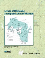
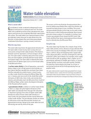
<strong>Ordovician</strong> System<br />
Cincinnatian Series<br />
Maquoketa Shale Formation<br />
Champlainian Series<br />
Sinnipee Group<br />
Galena Dolomite Formation<br />
Dubuque Member<br />
Stewartville Member<br />
Prosser Member<br />
Decorah Shale Formation<br />
Ion Member<br />
Guttenberg Member<br />
Spechts Ferry Member<br />
Generalized Geologic Column<br />
for Southwestern <strong>Wisconsin</strong><br />
Platteville Limestone Formation<br />
Quimby's Mill Member<br />
MacGregor Member<br />
Pecatonica Member<br />
1<br />
Ancell Group<br />
St. Peter Sandstone Formation<br />
Glenwood Member<br />
Tonti Member<br />
erosional unconformity<br />
Canadian Series<br />
Prairie du Chien Group<br />
Shakopee Formation<br />
Willow River Dolomite Member<br />
New Richmond Sandstone Member<br />
7---- erosional unconformity ----?<br />
Oneota Dolomite Formation<br />
-4-
Cambrian System<br />
St. Croixan Series<br />
Trempealeau Group<br />
Jordan Sandstone Formation<br />
Sunset Point Member<br />
Van Oser Member<br />
Norwalk Member<br />
7---- erosional unconformity ----7<br />
St. Lawrence Formation<br />
Lodi Siltstone i'Vlember<br />
Black Earth Dolomite Member<br />
Franconia Formation<br />
Reno Member<br />
Mazomanie Member<br />
Tomah Member<br />
Birkmose Membe!2<br />
Ironton Member<br />
Dresbach Group<br />
2<br />
Galesville Sandstone Formation<br />
?---- erosional unconformity ----?<br />
Eau Claire Formation<br />
Mt. Simon Sandstone Formation<br />
---- erosional unconformity ----<br />
1 Modified from classification proposed by Illinois Geological Survey<br />
(Templeton & Willman, 1963).<br />
2 Propose combining Ironton with Galesville as members <strong>of</strong> a single<br />
formation.<br />
-5-
TWENTY-NINTH ANNUAL TRI-STATE GEOLOGICAL<br />
FIELD CONFERENCE<br />
ACKNOWLEDGMENTS<br />
Arrangements for this trip would have been impossible were it not for<br />
the help <strong>of</strong> many persons. I am deeply grateful to George F. Hanson, State<br />
Geologist, for many discussions and a review <strong>of</strong> the trip.<br />
Adeline Colvin, Beth Czerwonka, and Sue Buchen <strong>of</strong> the Survey staff saw<br />
to the typing and final compilation <strong>of</strong> the field guide.<br />
Special thanks to operators <strong>of</strong> the Davis and Richardson Stone Quarry <strong>of</strong><br />
Spring Green for permission to visit their property.<br />
Saturday Morning, October 9, 1965<br />
GENERAL DISCUSSION<br />
The Cambrian and <strong>Ordovician</strong> rocks <strong>of</strong> the Upper Mississippi Valley area<br />
have been subjected to what at one time would have been considered !!exhaustive<br />
study". However, in the light <strong>of</strong> results <strong>of</strong> recent investigations<br />
<strong>of</strong> modern sediments and sedimentation the ITclassic" explanations for these<br />
rocks have had to be reexamined. The purpose <strong>of</strong> this year's field conference<br />
is to reexamine certain <strong>of</strong> these rocks, their large and small scale<br />
features and their interrelationships, to determine if the classical interpretations<br />
<strong>of</strong> geologic history and <strong>of</strong> the constitution and persistence <strong>of</strong><br />
rock units can still be held valid.<br />
The Cambrian and <strong>Ordovician</strong> rocks <strong>of</strong> this area have long been recognized<br />
as ITcyclic lT<br />
, that is they occur as a sequence <strong>of</strong> alternating layers <strong>of</strong><br />
orthoquartzitic sandstone and <strong>of</strong> carbonate rocks. However, the beginnings<br />
and ends <strong>of</strong> the cycles, their components, and their similarities and differences<br />
went unnoticed or at least unrecorded. It is these features that must<br />
now be examined.<br />
When selecting the beginning <strong>of</strong> a cycle one can go to the "beginning!!<br />
or base <strong>of</strong> the rock section to be studied. At the base <strong>of</strong> the rock section<br />
in the Upper Mississippi Valley area is an erosional surface developed on<br />
Precambrian rocks. It is believed that this surface formed during a time<br />
when the sea had withdrawn far from <strong>Wisconsin</strong>, possibly beyond or at least<br />
to the geographic vicinity <strong>of</strong> the modern Appalachian mountains on the southeast<br />
and equally as far to the south and <strong>southwest</strong>. The disposition <strong>of</strong> the<br />
sea in areas to the north is unknown for that time.<br />
Over the erosion surface there was deposited a layer <strong>of</strong> orthoquartzitic<br />
sandstone. This sandstone is evenly-bedded, may be medium- to massivebedded,<br />
is cross-bedded, is coarse- and medium-grained, and is moderately<br />
well-sorted to well-sorted. It is believed to have formed in the beachnearshore<br />
environment <strong>of</strong> an encroaching sea. The age <strong>of</strong> this layer <strong>of</strong> sand<br />
is given as Early Cambrian in Tennessee (the Erwin Sandstone) and as Late<br />
Cambrian in <strong>Wisconsin</strong> (the Mt. Simon Sandstone) which would tend to indicate<br />
-6-
transgression.<br />
In <strong>Wisconsin</strong> the basal sandstone unit, namely the Mt. Simon, consists<br />
in its upper 20' to 40' <strong>of</strong> alternating beds <strong>of</strong> poorly-sorted, argillaceous<br />
and silty sandstone with abundant vertical burrows and <strong>of</strong> moderately wellto<br />
well-sorted medium- to coarse-grained, medium- and thin-bedded sandstone.<br />
It is postulated that this lithology developed seaward <strong>of</strong> the beach-nearshore<br />
environment in an area where less sediment was in transport, where<br />
available wave and/or current energy was high, and where the bottom was reworked<br />
by either animals or by storms and/or currents. Modern deposits <strong>of</strong><br />
similar character are described as forming in the "nondepositional" environment<br />
<strong>of</strong> the shelf in the Gulf <strong>of</strong> Mexico (van Andel, 1960).<br />
These deposits are succeeded by argillaceous and calcareous, fossiliferous,<br />
fine- and very fine-grained generally thin-bedded and cross-bedded,<br />
sandstone that may be glauconitic, or by calcareous, fossiliferous, sandy<br />
and silty shale, namely the Eau Claire Formation. The Eau Claire Formation<br />
is thought to have formed in what van Andel (1960) referred to on the Gulf<br />
<strong>of</strong> Mexico shelf as the "depositional!! environment which is located generally<br />
seaward <strong>of</strong> the nondepositional environment in an area <strong>of</strong> relatively low<br />
available energy compared to more landward environments.<br />
In southern <strong>Wisconsin</strong> the Eau Claire contains a carbonate unit in its<br />
upper part which when traced southward to northeastern Illinois (Buschbach,<br />
1964) and into Missouri is considered to be at least in part the lithostratigraphic<br />
equivalent <strong>of</strong> the Bonneterre Dolomite Formation. The carbonate<br />
lithology is believed to have developed in areas <strong>of</strong> the shelf where<br />
conditions conducive to carbonate precipitation and animal and plant life<br />
existed. On the present shelf in the Gulf <strong>of</strong> Mexico these areaS are widely<br />
scattered in the nondepositional and depositional environments so that no<br />
continuous layer has as yet formed. However, where such deposits are permitted<br />
to grow and expand they would eventually coalesce and form such a<br />
layer <strong>of</strong> interrelated reef, <strong>of</strong>freef, and bank materials.<br />
We have so far established that in the broadest terms four major lithotopes<br />
can be recognized in these rocks, namely the basal orthoquartzitic<br />
sandstone lithotope succeeded by the poorly-sorted sandstone lithotope, the<br />
argillaceous lithotope, and finally the carbonate lithotope. Are there more?<br />
As we proceed upwards in the geologic section the next unit is the<br />
Galesville Sandstone Formation. The Galesville consists <strong>of</strong> moderately wellsorted<br />
to well-sorted, generally medium-grained, medium- to massive-bedded,<br />
cross-bedded, quartz sand. Except for the grain-size, which is generally<br />
finer than in the Mt. Simon, the Galesville and Mt. Simon sandstones are<br />
similar in all important aspects including texture, sedimentary structures<br />
and composition. They are dissimilar in that supposedly there is no erosion<br />
surface beneath the Galesville.<br />
Two thoughts need to be pursued at this point; namely, what does the<br />
Galesville represent in terms <strong>of</strong> geologic history, and is the Galesville<br />
unconformable with older rocks? In order to interpret the depositional<br />
history <strong>of</strong> the Galesville Sandstone it is helpful to refer first to the oldest<br />
lithologic unit in the sequence having similar textural) compositional,<br />
-7-
and structural properties, namely the Mt. Simon Sandstone.<br />
If the assumption is correct that the Mt. Simon Sandstone formed in the<br />
beach-nearshore environment, as is described above, then one can assume because<br />
<strong>of</strong> similarities <strong>of</strong> texture, composition, sedimentary structures, and<br />
stratigraphic relationships that the Galesville formed in a similar environment<br />
<strong>of</strong> deposition. What must then be determined is whether these deposits<br />
<strong>of</strong> the beach-nearshore environment were formed when the sea regressed or<br />
when it transgressed.<br />
One might expect that if the sea regressed,<br />
posited in the beach-nearshore environment would<br />
erosion with each new measure <strong>of</strong> regression. It<br />
then materials newly debe<br />
exposed to subaerial<br />
would be unusual if in this<br />
erosion process materials in the newly exposed beach-nearshore deposits<br />
would not be eroded and transported to the retreating shoreline. In fact,<br />
under conditions <strong>of</strong> regressions deposits <strong>of</strong> this environment would be expected<br />
to be thin when deposited and if preserved.<br />
If the Galesville Sandstone formed during transgression, then one<br />
could expect to find conditions similar to those which occur with the Mt.<br />
Simon Sandstone, namely a basal erosional unconformity, variable thickness<br />
due to irregularities <strong>of</strong> the basal contact surface, an even upper contact,<br />
and similar textural, compositional, and sedimentary structural features.<br />
Of all these characters the only one that has not been confirmed beyond a<br />
reasonable doubt is the basal erosional unconformity.<br />
The Galesville Formation can be shown to vary from about 20 feet to<br />
over 160 feet in thickness in <strong>Wisconsin</strong>. When one considers the basal contact<br />
<strong>of</strong> the Galesville and the relationship <strong>of</strong> the Galesville to older rock<br />
units there are certain peculiarities that are difficult to explain except<br />
by post-Eau Claire/pre-Galesville regression <strong>of</strong> the sea and erosion. For<br />
example, Twenh<strong>of</strong>el, Raasch, and Thwaites (1935) pointed out that as one proceeds<br />
from west to east across <strong>Wisconsin</strong> the Eau Claire lithology !!blends"<br />
into sandstones <strong>of</strong> the Mt. Simon and Galesville "aspect". They also point<br />
out that the Eau Claire can be divided into two faunal zones and that as<br />
one proceeds from west to east the Eau Claire thins and the upper fossil<br />
zone first disappearsknd then the lower fossil zone, which suggests progressively<br />
greater truncation from west to east. Add to this the observation<br />
that there is a coarse conglomerate about 10 feet thick at the base <strong>of</strong><br />
rocks considered to be the Galesville in the Northern Peninsula <strong>of</strong> Michigan<br />
(Chapel Rock Member <strong>of</strong> the Munising Formation: Hamblin, 1958) and that this<br />
is underlain by a quartz sandstone suspected <strong>of</strong> being equivalent to the Mt.<br />
Simon and there is even greater reason to consider the Galesville as having<br />
developed during transgression.<br />
There are four more cycles with lithotopes similar to and in the same<br />
order as those which occur in the basal cycle which contains the Mt. Simon<br />
Sandstone. This is important because it illustrates the fact that whether<br />
or not the history presented here is true or even approaches the truth there<br />
was a repetition <strong>of</strong> environments and events in the geologic history <strong>of</strong> this<br />
area.<br />
The discussion presented here applies equally to each <strong>of</strong> the cycles and<br />
their parts and is intended to provide food-fvr-thought.<br />
-8-
Mileage<br />
STOP #1<br />
0.0 Road cut at north side <strong>of</strong> County Trunk Highway K about 1 mile northeast<br />
<strong>of</strong> Genoa in the NEl, SW!, Sec. 22, T.13N., R.7W., Vernon County.<br />
Refer to Stoddard 15' quadrangle. Mileage is recorded beginning at the<br />
base <strong>of</strong> the Oneota Formation.<br />
This section is best studied from bottom to top. The lithologic<br />
changes which occur in this exposure are interpreted to indicate transgression<br />
- regression - transgression.<br />
The Franconia Formation outcrops at the base <strong>of</strong> the exposure. It<br />
consists <strong>of</strong> glauconitic fine-grained, calcareous, thin- to medium-bedded,<br />
cross-bedded sandstone. The Franconia is believed to have developed on an<br />
open and shallow shelf located seaward <strong>of</strong> the beach area, the depositional<br />
shelf area <strong>of</strong> van Andel (1960) and van Andel and Curray (1960).<br />
The Franconia is overlain by the St. Lawrence Formation which consist<br />
<strong>of</strong> two members, the Black Earth Member consisting <strong>of</strong> dolomite locally containing<br />
abundant cryptozoa, and the Lodi member which is a thin- to mediumbedded<br />
dolomitic, sandy siltstone. The Black Earth Member is conventionally<br />
described as the lowest member but Nelson (1956) has shown that it thins<br />
northward to a tongue that is enclosed by the Lodi Member. At this stop the<br />
Black Earth Member is covered. The environment <strong>of</strong> deposition <strong>of</strong> the St.<br />
Lawrence Formation is believed to have been an area <strong>of</strong> the shelf that received<br />
a minor amount <strong>of</strong> land derived sediment, to have been located seaward<br />
<strong>of</strong> the area <strong>of</strong> Franconia development and to have possessed the necessary<br />
conditions for development <strong>of</strong> carbonate deposits. The Franconia and<br />
St. Lawrence are believed to represent the close <strong>of</strong> the transgressive phase<br />
<strong>of</strong> a cycle. The lower part <strong>of</strong> the cycle will be seen at Stop 2.<br />
The Lodi is overlain by the Norwalk Member <strong>of</strong> the Jordan Sandstone<br />
Formation. The contact is selected at the upward change from calcareous<br />
siltstone or silty very fine-grained sandstone to a fine-grained slightly<br />
calcareous sandstone which contains only a trace or no silt. The basal 6<br />
inches consists <strong>of</strong> materials ranging in grain size from granules down to<br />
silt and is locally iron-enriched. The Norwalk and succeeding Van Oser members<br />
are believed to have developed in a beach-nearshore environment. This<br />
requires that the sea regressed after deposition <strong>of</strong> the St. Lawrence carbonates<br />
and readvanced to deposit the Norwalk and Van Oser.<br />
The Norwalk is succeeded by the Van Oser Member. The two members are<br />
distinguished on the basis <strong>of</strong> grain size and bedding character. The contact<br />
between them is selected at the upward change from thin and/or medium-bedded,<br />
fine-grained, sandstone to massive-bedded, medium- to coarse-grained, sandstone.<br />
Above the Norwalk is the Sunset Point Member (the Madison Sandstone<br />
<strong>of</strong> Wanenmacher, Twenh<strong>of</strong>el, and Raasch, 1934; Twenh<strong>of</strong>e1, Raasch, and Thwaites<br />
1935; Ulrich, 1936). The Sunset Point consists <strong>of</strong> argillaceous and dolomitic<br />
sandstone, <strong>of</strong> dolomite "conglomerate" J and <strong>of</strong> thin beds <strong>of</strong> dolomite.<br />
-10-
Raasch examined the overlying Oneota Formation in this area, subdivided<br />
the Oneota into 4 members, and described it as being unconformable with<br />
the Sunset Point. Maximum thickness assigned to the Sunset Point was 24<br />
feet. It is distinguished from the Oneota by its lack <strong>of</strong> chert, oolites,<br />
and cryptozoa. On this basis approximately 54 feet are assigned to the<br />
Sunset Point at this exposure. The Sunset Point is believed to have developed<br />
seaward <strong>of</strong> the beach-nearshore environment, in an area usually<br />
hospitable to life and development <strong>of</strong> carbonate deposits but into which<br />
neighboring environments <strong>of</strong>ten encroached at times <strong>of</strong> higher energy which<br />
caused shifts in sediment distribution patterns.<br />
The Sunset Point is succeeded by the Oneota Dolomite Formation <strong>of</strong><br />
<strong>Ordovician</strong> age. The contact is selected at the upward change from argillaceous<br />
and sandy dolomite having a "reworked!! appearance locally, to a dolomite<br />
that may be conglomeratic in its base and which contains oolites,<br />
chert, and cryptozoa. The Oneota is believed to be the product <strong>of</strong> an environment<br />
<strong>of</strong> carbonate deposition and local reef development.<br />
Portions <strong>of</strong> this same sequence <strong>of</strong> rocks will be seen at stops 5, 6,<br />
9, 10, and 11. It will be noted that each unit persists and that as we<br />
approach the <strong>Wisconsin</strong> arch each unit thins. Only the upper unit, the Sunset<br />
POint, shows any obvious tendency toward lithologic change, namely a<br />
decrease in clastic content,<br />
The subdivisions <strong>of</strong> the Jordan Formation noted here were recognized<br />
by Ulrich (1936) and more recently by Ahlen (1952) in a Master's thesis study<br />
<strong>of</strong> the Jordan Formation. Although Ahlen did not recognize the upper unit as<br />
the Sunset Point he did show each unit to thin toward the arch. The lower<br />
unit, the Norwalk, was shown to be irregular in thickness varying from 20 to<br />
60 feet, with some indication <strong>of</strong> thinning toward the arch, even to disappearance.<br />
The other units are all shown to thin in rather uniform manner<br />
onto the arch. Another significant point made by Ah1en is that the subdivisions<br />
<strong>of</strong> the Jordan overlap in the direction <strong>of</strong> the arch. It is unfortunate<br />
that he did not cross the arch in his study. If he had done so he<br />
might have recognized the position <strong>of</strong> the Sunset Point in his classification.<br />
The first stop Sunday morning, Stop #11, will be at the type section<br />
<strong>of</strong> Raasch's Sunset Point Member.<br />
Outcrop description for Stop #1<br />
<strong>Ordovician</strong> System<br />
Prairie du Chien Group<br />
Oneota Formation - +12.0 feet<br />
1. Dolomite, gray, slightly to very sandy, massive,<br />
locally conglomeratic in basal 6 1T<br />
• Cryptozoan<br />
beds<br />
+<br />
- 6' above base; oolites in bed 5' above<br />
base; first chert ± 12' above base<br />
-11-<br />
Thickness<br />
+12' 0'-12'
Cambrian System<br />
Trempealeau Group<br />
Jordan Formation<br />
Sunset Point Member - 53.6 feet<br />
2. Sandstone, light yellow brown, medium- and<br />
fine-grained, very dolomitic, cross-bedded,<br />
uneven base.<br />
3. Sandstone, light gray, coarse- and very<br />
coarse-grained with some clasts from<br />
underlying unit; uneven base.<br />
4. Sandstone, ledge, reddish brown, mediumto<br />
very fine-grained, very dolomitic,<br />
cross-bedded. Scattered fine grained<br />
dolomite clasts.<br />
5. Sandstone, light gray, coarse- and<br />
very coarse-grained.<br />
6. Same as #4.<br />
7. Sandstone, gray, fine- to coarse-grained,<br />
with dolomite and green clay. Very rough<br />
surface texture.<br />
8. Sandstone, light yellow gray, fine- and<br />
medium-grained, very dolomitic, with<br />
clasts.<br />
9. Sandstone, gray, fine- and very finegrained.<br />
1.5' -:t o. 5 '<br />
0.7' -:to.3 '<br />
1.2'<br />
0.3'<br />
1.3'<br />
1.5'<br />
1.0'<br />
0.5'<br />
10. Sandstone, light yellow brown, fine- and very<br />
fine-grained, very dolomitic. 0.4'<br />
COVERED INTERVAL<br />
11. Sandstone, light yellow brown, fine- and<br />
medium-grained, thoroughly reworked,<br />
appears massive.<br />
12. Sandstone, pale green, fine- and very finegrained<br />
with little medium, argillaceous,<br />
with dolomite stringers.<br />
13. Sandstone, same as #11, only medium-bedded<br />
with locally undulating beds.<br />
-12-<br />
3.0'<br />
0.8'<br />
Thickness<br />
12' -13.5'<br />
13.5'-14.2'<br />
14.2'-15.4'<br />
15.4'-15.7'<br />
15.7'-17.0'<br />
17.0'-18.5'<br />
18.5'-19.5'<br />
19.5'-20.0'<br />
20.0'-20.4'<br />
20.4'-30.4'<br />
30.4'-33.4'<br />
33.4'-34.2'<br />
34.2'-37.2'
14. Sandstone, reentrant, light green gray, mediumand<br />
fine-grained, argillaceous with green shale<br />
stringers.<br />
0.5'<br />
15. Sandstone, light yellow brown, fine- and mediumgrained,<br />
thoroughly reworked; appears massive.<br />
Beds in base locally appear stromatolitic. Some<br />
beds locally slightly sandy. 7.0'<br />
16. Sandstone, light green gray, medium- and fjnegrained,<br />
argillaceous, with thin green shale<br />
stringers, laterally discontinuous dolomite<br />
stringers up to 3" thick, and abundant clasts.<br />
17. Sandstone, light yellow gray to light yellow<br />
brown, fine- and very fine-grained with. little<br />
medium, medium-bedded to massive-bedded, very<br />
dolomitic. Few horizontally discontinuous<br />
silty partings.<br />
2.0 '<br />
3.0'<br />
18. Sandstone, light green gray, medium- and finegrained,<br />
argillaceous, with some thin green shale<br />
stringers and laterally discontinuous dolomite<br />
stringers up to 3 11<br />
thick. 0.9 '<br />
19. Sandstone, light yellow gray to light yellow<br />
brown, fine- and very fine-grained with little<br />
medium, medium-bedded at base to massivebedded<br />
at top, dolomitic, with few horizontally<br />
discontinuous silty stringers. Upper 6 11<br />
locally shows signs <strong>of</strong> reworking.<br />
20. Sandstone, very light green gray, medium- and<br />
fine-grained, with abundant thin green shale<br />
stringers, locally has clasts <strong>of</strong> dolomitic<br />
sandstone.<br />
21. Sandstone, light red brown, coarse- and<br />
medium-grained, very dolomitic, with abundant<br />
fine-crystalline dolomite pebbles in<br />
basal 10", medium- and thick-bedded, crossbedded,<br />
poorly sorted.<br />
22. Sandstone, very light yellow brown, poorly<br />
sorted, grains range in size from granules<br />
down to silt with abundant green clay stringers<br />
maSSive, cross-bedded. Basal 0' to I' lacks<br />
fines and weathers as reentrant.<br />
-13-<br />
4.0'<br />
1.3 '<br />
3.5'<br />
2.5'<br />
Thickness<br />
37.2'-37.7'<br />
37 .7' -44.7 '<br />
44.7'-46.7'<br />
46.7 '-49.7 '<br />
49.7'-50.6'<br />
50.6'-54.6'<br />
54.6'-55.9'<br />
55.9'-59.4'<br />
59.4'-61.9'
23. Sandstone, red brown, medium- and coarsegrained,<br />
very dolomitic, with steeply dipping<br />
cross-beds. Conglomeratic in some beds,<br />
notably in base, with ripclasts <strong>of</strong> finer<br />
texture and lighter color. Finer grained at<br />
top.<br />
24. Sandstone, slight reentrant, light yellow<br />
brown, medium-grained with clasts <strong>of</strong><br />
lighter color. Locally slightly argillaceous.<br />
Van Oser Member - 22.5 feet<br />
25. Sandstone, light gray, coarse- and mediumgrained,<br />
massive-bedded, cross-bedded,<br />
with numerous pea-sized sandstone concretions.<br />
Top even. Variable thickness.<br />
Grades laterally into top <strong>of</strong> unit #25.<br />
3.5'<br />
0.2'<br />
26. Sandstone, very light yellow gray, coarseand<br />
medium-grained with little very coarse,<br />
massive, cross-bedded, with some finer textured<br />
clasts in basal 4 feet. Some small pockets <strong>of</strong><br />
very coarse sand and granules. Upper 6 feet<br />
grades laterally into bed #25. 15':3'<br />
27. Sandstone, light yellow brown, medium- and<br />
coarse-grained with little fine and very<br />
coarse, massive- to medium-bedded, crossbedded,<br />
dolomite cement. Base irregular.<br />
Bed laterally discontinuous.<br />
28. Sandstone, white, medium- and fine-grained,<br />
massive, cross-bedded. Upper 6" dolomite<br />
cemented.<br />
Norwalk Member - 27.5 feet<br />
29. Sandstone, brown, medium- and fine-grained,<br />
cross-bedded, irregular medium beds. Locally<br />
has a ripclast at base. Some coarse sand in<br />
top.<br />
30. Mostly covered. Some hard ledges, but mostly<br />
slumped. Appears to be a medium- and finegrained,<br />
gray, friable sandstone.<br />
-14-<br />
3'<br />
3'<br />
4'<br />
Thickness<br />
61.9-65.4'<br />
65.4'-65.6'<br />
65.6'-68.6'<br />
68.6'-83.6'<br />
83.6'-85.1'<br />
85.1'-88.1'<br />
88.1'-91.1'<br />
91.1'-95.1'
Mileage<br />
1.3 STOP SIGN. Turn right (north), caution left.<br />
1.7 STOP SIGN. Junction with Highway 35. DANGER. Turn left (south).<br />
2.3 Outcrop <strong>of</strong> Franconia Formation on left. Dam on right.<br />
2.8 Outcrop <strong>of</strong> Franconia Formation on left behind historical monument.<br />
Monument recognizes dam as one <strong>of</strong> many on Mississippi River.<br />
3.1 Dairyland Power Cooperative nuclear power plant on right.<br />
4.2 Outcrop <strong>of</strong> Franconia Formation at road level and <strong>of</strong> the Jordan<br />
Sandstone Formation and the Oneota Dolomite Formation above.<br />
6.4 Cross Bad Axe River.<br />
STOP #2<br />
8.4 Pull <strong>of</strong>f as far as possible on right (west) side <strong>of</strong> highway. Exit<br />
from right side <strong>of</strong> vehicles. Use extreme caution when crossing<br />
highway to outcrop.<br />
Rock is exposed in roadcut and bluff located at left (east) side<br />
<strong>of</strong> Highway 35 at north edge <strong>of</strong> village <strong>of</strong> Victory in swi, NEi,<br />
Sec. 21, T.12N., R.7W., Vernon County. Refer to Ferryville 15' topographic<br />
quadrangle.<br />
At Stop #1 we saw the upper part <strong>of</strong> this section. For this reason we<br />
will examine only the lower portion <strong>of</strong> the section exposed in the road cut<br />
which includes portions <strong>of</strong> the Ironton Member and the Franconia Formation.<br />
The Ironton Member was originally assigned to the Franconia Formation<br />
by Thwaites (1923). Thwaites defined the Ironton as a few feet <strong>of</strong> hard calcareous<br />
coarse-grained sandstone forming the basal member <strong>of</strong> the Franconia<br />
in <strong>southwest</strong>ern <strong>Wisconsin</strong>. The next year Ulrich (1924) described it as<br />
being composed mainly <strong>of</strong> reworked, washed, and relatively coarse residual<br />
grains <strong>of</strong> Dresbach Sandstone the surface <strong>of</strong> which had been previously subjected<br />
to subaerial leaching and erosion. He further stated that the Ironton<br />
extends downward to the lowest plane indicating reworking and redeposition<br />
<strong>of</strong> the weather-loosened top sands <strong>of</strong> the underlying Dresbach and that<br />
to make sure <strong>of</strong> identification one should search for its characteristic<br />
fossils, namely the Camaraspis (Elvinia) fauna.<br />
Ulrich's definition stood until 1954 without change. In that year Berg<br />
made a detailed study <strong>of</strong> the Franconia lithology in <strong>southwest</strong>ern <strong>Wisconsin</strong><br />
and southeastern Minnesota and proposed a lithostratigraphic subdivision in<br />
which he replaced the name Ironton with Woodhill. Berg justifies the name<br />
change with the belief that the term Ironton Member has become synonymous<br />
with Elvinia zone in which case it is a biostratigraphic subdivision. The<br />
name Woodhill was thus proposed by Berg as one which has no faunal connotation. <br />
-16-
It is proposed here that the name Ironton Member as originally proposed<br />
and defined by Thwaites, who excluded mention <strong>of</strong> a fauna, be retained<br />
for this unit. It is believed that little or no benefit is gained by changing<br />
the name when the main part <strong>of</strong> the original definition refers specifically<br />
to lithology and when the name in its lithologic sense has been used<br />
for many years by field geologists. It is further suggested that there is<br />
justification for separating the Ironton from the overlying Franconia<br />
"greensands" on the basis <strong>of</strong> lithology and that the Ironton be placed in<br />
the same lithostratigraphic unit as the underlying Galesville Sandstone from<br />
which it can be separated only with difficulty on the outcrop and seldom in<br />
the subsurface. It is obvious at this Stop that the Ironton is markedly<br />
different from the overlying greensands in texture, composition, and outcrop<br />
expression. The contact <strong>of</strong> these two in the subsurface is one <strong>of</strong> the<br />
easiest to determine. Although we cannot see the Galesville-Ironton contact<br />
at this stop we will have the opportunity provided there is sufficient time<br />
to see it at Stop #7 this afternoon. At Stop #7 there is very little difference<br />
between the Ironton and Galesville.<br />
In support <strong>of</strong> this realignment <strong>of</strong> lithostratigraphic units there are<br />
the results <strong>of</strong> recent work done by Grover Emrich at the Illinois Geological<br />
Survey (1962) and by John Andrew <strong>of</strong> the University <strong>of</strong> <strong>Wisconsin</strong> (1965).<br />
Emrich studied the Ironton-Galesville in the Upper Mississippi valley area<br />
and concluded that the two could be separated only with difficulty in the<br />
outcrop and in the subsurface. Andrew made a detailed physical and heavy<br />
mineral study <strong>of</strong> six widely spaced exposures <strong>of</strong> this interval in <strong>southwest</strong>ern<br />
<strong>Wisconsin</strong> and reached the same conclusion with the suggestion that<br />
the Ironton and Galesville should be combined.<br />
Traced eastward onto the arch the Ironton thins. South <strong>of</strong> the <strong>Wisconsin</strong><br />
River, in Iowa County near Lone Rock, there is no or less than 6 inches<br />
<strong>of</strong> Ironton and near Lake Delton there is less than 1 foot <strong>of</strong> Ironton. There<br />
is some indication that the Ironton thickens east <strong>of</strong> the arch as, for example,<br />
near Tower Hill State Park where over 3 feet <strong>of</strong> Ironton is present<br />
and at the American-Marietta Quarry south <strong>of</strong> Portage, Columbia County,<br />
where about 6 feet <strong>of</strong> Ironton is present.<br />
Above the Ironton Member at Stop #2 are the Franconia "greensands".<br />
Berg subdivided this rock unit on the basis <strong>of</strong> litho<strong>stratigraphy</strong>, in<br />
ascending order, into the Birkmose, Tomah, Reno, and Mazomanie members.<br />
All but the Mazomanie, which is a facies member, are represented here. The<br />
Birkmose Member consists <strong>of</strong> 7.1 feet <strong>of</strong> glauconitic dolomite and dolomitic<br />
sandstone and <strong>of</strong> ripclast conglomerate with a glauconitic sand matrix.<br />
Traced eastward the Birkmose thins as, for example, near Lake Delton where<br />
it is about 1 foot thick and as will be seen at Stop #8 where it is only<br />
3 feet thick.<br />
The overlying Tomah and Reno members are not known to thin eastward<br />
nor does their lithologic character change markedly from what is seen at<br />
this exposure. Of particular note are the numerous intraformational<br />
conglomerates in the Reno. These are interpreted to indicate short periods<br />
<strong>of</strong> high energy as might result from storms over a broad shallow and open<br />
shelf area.<br />
-17-
The Mazomanie Member does not occur in <strong>southwest</strong>ern <strong>Wisconsin</strong>. It<br />
appears midway in the Reno Member at about Richland Center and thickens<br />
eastward until in the vicinity <strong>of</strong> Mazomanie it comprises the majority <strong>of</strong><br />
the Franconia. Berg (1954) reported it as a <strong>southwest</strong>ward pinching wedge.<br />
Driscoll (1959) and Hamblin (1961) also showed this to be the case.<br />
Investigation in progress at the <strong>Wisconsin</strong> Geological and Natural History<br />
Survey suggests that the Mazomanie is in reality a tongue that has a very<br />
irregular outer limit and which occurs within the greensands, that it is<br />
thickest over the <strong>Wisconsin</strong> dome and arch and thins outward, and that it<br />
has a southward extension <strong>of</strong>f <strong>of</strong> the <strong>Wisconsin</strong> dome into the Madison area.<br />
It is believed to represent deposits formed in a shallow water near-shore<br />
envlronment that shifted position in response to fluctuations <strong>of</strong> sea-level<br />
and, thus, indicates that there was a minor retreat <strong>of</strong> the sea from the<br />
<strong>Wisconsin</strong> dome during the Franconia depositional interval. We will see the<br />
Mazomanie at Stop #9.<br />
The description provided below is a composite <strong>of</strong> those made by G. O.<br />
Raasch(Kansas Geo1. Soc. Guidebook to 9th. Annual Field Conference, 1935,<br />
Stop #17, pp. 430-31), R. W. Tillman (M-:B. thesis, Uni v. Wisc., 1960,<br />
Section #37, pp. 175-176), and M.E. Ostrom (September 1961 and May 1965)<br />
with mOdifications by Ostrom. At the time <strong>of</strong> Raasch's description a<br />
complete section including the lower 93.5 feet <strong>of</strong> the Oneota Dolomite down<br />
to the base <strong>of</strong> the Birkmose Member <strong>of</strong> the Franconia Formation was exposed.<br />
All <strong>of</strong> the lower calcareous beds <strong>of</strong> the Trempealeau Group, namely the St.<br />
Lawrence Formation, and most <strong>of</strong> the upper part <strong>of</strong> the Franconia Formation<br />
is now covered. The Birkmose and underlying Ironton have since been<br />
exposed.<br />
Outcrop description for Stop 2.<br />
<strong>Ordovician</strong> System<br />
Prairie du Chien Group<br />
Oneota Formation - 93.5 feet.<br />
1. Dolomite, gray, crystalline, granular, porous, weathers<br />
rough, massive- and thick-bedded, irregular chert bodies<br />
at some horizons; cavities filled with calcite. lS.O'<br />
2. Dolomite, light buff, compact and finest in grain<br />
in lower part becoming coarser and porous above,<br />
undulatory laminations; thick-bedded, +4'<br />
3. Dolomite, white, fine-crystalline, compact, dull<br />
luster, thinly laminated, medium-bedded (3').<br />
Abundant dendrites and druses <strong>of</strong> quartz<br />
arranged in bands in lower part.<br />
4. Dolomite, buff, earthy, well-bedded, thinand<br />
medium-bedded (6"-12"), fucoids (overgrown<br />
with brush).<br />
-18-<br />
12.8'<br />
8.2'<br />
22.5'<br />
Thickness<br />
18.0'-30.8'<br />
30.8'-39.0'<br />
39.0'-61.5'
5. Exposed in steep bluff. Dolomite, light gray,<br />
sandy, with an oolitic zone a few feet above<br />
base. Near the top is a cryptozoochiton zone<br />
below which is about 1 foot <strong>of</strong> dense but<br />
rather fine-crystalline oolitic dolomite, thin<br />
layers <strong>of</strong> sandstone, and green-shale speckled<br />
beds. Lower 5 ft. is conglomeratic.<br />
Cambrian System<br />
Trempealeau Group - 166.2'<br />
Jordan Formation<br />
Sunset Point Member - 19.2'<br />
6. Sandstone, very light yellow gray, mediumgrained,<br />
dolomitic, rather thin-bedded; 4 ft.<br />
above base is a conglomerate with flat pebbles<br />
<strong>of</strong> fine-grained sandstone; horizontal<br />
borings in some layers.<br />
7. Sandstone, light yellow gray, cross-bedded,<br />
poorly-sorted, medium- to very fine-grained,<br />
with stringers <strong>of</strong> green shale.<br />
Van Oser Member - 26.0 1<br />
8. Sandstone, light yellow gray, numerous peasized<br />
sand concretions, coarse- to finegrained,<br />
cross-bedded, slightly calcareous.<br />
9. Sandstone, light yellow gray, medium-grained,<br />
massive-bedded, cross-bedded.<br />
10. Covered - Described by Raasch as sandstone,<br />
white and brown, medium- and coarse-grained,<br />
coarsest at top, friable, massive-bedded,<br />
cross-bedded in upper 20 feet.<br />
11. Sandstone, white to light yellow gray, mediumgrained,<br />
massive, cross-bedded in lenticular<br />
units <strong>of</strong> varied inclination, numerous borings.<br />
Norwalk Member - 34.2 feet<br />
12. Sandstone, very light yellow gray, fine-grained,<br />
horizontally laminated.<br />
Covered interval. Described by Raasch (1935) as<br />
a. Sandstone, light brown, fine-grained, horizontally<br />
and cross-laminated; 18" bed 0.5 1<br />
above this has great number <strong>of</strong> borings.<br />
-19-<br />
Thickness<br />
32.0' 61.5'-93.5'<br />
17.5' 93.5'-ll1.0'<br />
2.0' 111.0'-113.0'<br />
3.0' 113.0'-116.0'<br />
6.0' 116.0'-122.0'<br />
52.0' 122.0'-174.0'<br />
17.0' 174.0'-191.0'<br />
11.5' 191.0'-202.5'<br />
1.0' 202.5'-203.5'
. Dolomite, gray, sandy, maSSive, rough weathering;<br />
contains undulatory structures like<br />
cryptozoa.<br />
c. Sandstone and siltstone, interlaminated, finegrained,<br />
yellow to brown-gray, fucoidal markings,<br />
fragments <strong>of</strong> fossils.<br />
d. Sandstone, buff, dolomitic, very fine-grained,<br />
partings <strong>of</strong> siltstone, abundant Saukiella.<br />
e. Dolomite, sandy, gray, mostly thin-bedded.<br />
f. Dolomite, glauconitic, gray; conglomeratic with<br />
pebbles like bed below; Eurekia eos zone.<br />
St. Lawrence Formation<br />
Lodi Member - 29.4 feet.<br />
g. Sandstone, fine-grained, and siltstone, dolomitic<br />
yellow.<br />
h. Sandstone, fine-grained, micaceous, thin-bedded,<br />
marcasitic, few fossils including tlDikelocephalus<br />
5.8'<br />
8.8'<br />
13. I<br />
5.8'<br />
0.6'<br />
19.5'<br />
near norwalkensis. T! 6.0 I<br />
i. Siltstone, dolomitic, very fine-grained, dark<br />
gray, non-fissle with interlaminated fine sandstone<br />
bands toward top; meristomes.<br />
Black Earth Member - 8.0'<br />
j. Dolomite, firm, rather thin-bedded, gray,<br />
glauconitic.<br />
Franconia Formation - 131.2 feet<br />
Reno Member<br />
3.9'<br />
8.0'<br />
k. Conglomerate, pebbles ellipsoidal, <strong>of</strong> greensand<br />
and yellow dolomite like underlying beds; matriX,<br />
calcareous greensand; no pebbles in upper beds. 6.6'<br />
l. Greensand, much glauconite, somewhat micaceous,<br />
laminated. Dikelocephalus sp.<br />
3.8'<br />
m. Greensand, highly glauconitic, laminated,<br />
interlaminated with siltstone, dolomitic,<br />
yellow gray; contacts marked by large fucoids; a<br />
few bands <strong>of</strong> fine, yellow, micaceous, sandstone;<br />
a few inches <strong>of</strong> greensand conglomerate at base;<br />
silt mainly in upper part. Saukiella minor. 20.3'<br />
-20-<br />
Thickness<br />
203.5'-209.3'<br />
209.3'-218.1'<br />
218.1'-219.4'<br />
219.4'-225.2'<br />
225.2'-225.8'<br />
225.8'-245.3'<br />
245.3'-251.3'<br />
251.3'-255.2'<br />
255.2'-263.2'<br />
263.2'-269.8'<br />
269.8'-273.6'<br />
273.6' -293.9'
18. Dolomite, green gray, finely crystalline, much<br />
glauconite, little medium and fine sand, conglomeratic;<br />
contains abundant clasts <strong>of</strong> finergrained<br />
sandy material. Contains some structures<br />
that may be algal in origin. 1.4'<br />
19. Conglomerate with clasts <strong>of</strong> sandstone and dolomite<br />
in a matrix <strong>of</strong> greensand.<br />
20. Conglomeratic dolomite, green gray, finelycrystalline<br />
with abundant medium and fine<br />
sand grains, much glauconite, some algal<br />
structures, and sandstone clasts.<br />
21. Sandstone, yellow brown and red brown, fineand<br />
medium-grained with trace very fine.<br />
Abundant glauconite. Thin-bedded and irregularly-bedded.<br />
Locally conglomeratic.<br />
22. Conglomerate: varies in thickness from 3.0'<br />
down to 211. Consists <strong>of</strong> clasts <strong>of</strong> underlying<br />
sandstone in matrix <strong>of</strong> greensand.<br />
Where thin the lithology is that <strong>of</strong> thinlylaminated<br />
silty shale. Well-exposed about<br />
50 yards south <strong>of</strong> north end <strong>of</strong> exposure.<br />
Ironton Member - +19.7 feet<br />
0.8'<br />
0.7'<br />
2.5'<br />
3.0'<br />
23. Sandstone, red brown, medium-grained with trace<br />
<strong>of</strong> coarse, well-cemented with dolomite and limonite,<br />
massive- and medium-bedded, abundant brachiopods.<br />
2.4'<br />
24. Sandstone, yellow brown, medium- and coarsegrained<br />
with little fine, well-cemented with<br />
dolomite and limonite, uneven bedding planes,<br />
medium-bedded, abundant brachiopods. 2.0'<br />
25. Sandstone, light yellow brown, medium- and<br />
coarse-grained with little fine, massivebedded<br />
and cross-bedded. Note pinnacle<br />
weathering forms around vertical limonitecemented<br />
burrows. Scattered brachiopods.<br />
26. Sandstone, yellow gray, medium-grained with<br />
little coarse and fine, massive-bedded and<br />
cross-bedded, weathered surface moderately<br />
pitted. Few brachiopods, most abundant near<br />
top.<br />
-22-<br />
2.0'<br />
8.0'<br />
Thickness<br />
410.1'-411.5'<br />
411.5'-412.3'<br />
412.3'-413.0'<br />
413.0'-415.5'<br />
415.5'-418.5'<br />
418.5'-420.9'<br />
420.9'-422.9'<br />
422.9'-424.9'<br />
424.9'-432.9'
27. Sandstone, yellow gray, medium-grained with<br />
little coarse, fine and very fine, trace silt,<br />
poorly-sorted, massive; "burrowed" bed.<br />
28. Sandstone, yellow gray, coarse-grained with<br />
little medium and fine, trace silt, massivebedded,<br />
weathered surfaces pitted.<br />
29. Sandstone, light gray, medium-grained with<br />
coarse, fine and very fine, little silt,<br />
poorly-sorted, massive-bedded; "burrowed"<br />
bed.<br />
30. Sandstone, yellow gray, coarse-grained with<br />
little medium and fine, trace silt, massivebedded<br />
and cross-bedded, pitted in top.<br />
31. Sandstone, light gray, coarse-grained with<br />
much medium and fine, little very fine,<br />
little silt, massive; "burrowed lT<br />
bed.<br />
32. Sandstone, yellow gray, medium-grained with<br />
little coarse and fine, trace very coarse and<br />
very fine, massive-bedded, weathered surface<br />
pitted.<br />
BASE OF EXPOSURE AT ROAD LEVEL<br />
Mileage<br />
8.8 Enter village <strong>of</strong> Victory<br />
9.2 Turn left (east) on County Trunk "UU". DANGER.<br />
Thickness<br />
0.3' 432.9'-433.2'<br />
0.3' 433.2'-433.5'<br />
0.5' 433.5'-434.0'<br />
0.6' 434.0'-434.6'<br />
1.2 ' 434.6'-435.8'<br />
0.7 ' 437.5'-438.2'<br />
11.0 Roadcut in Sunset Point Member and quarry in overlying Oneota<br />
Dolomite.<br />
13.0 St. Peter Sandstone exposed in roadcut on left (north).<br />
13.8 STOP SIGN. Junction with Highway 82. Turn left (east).<br />
Caution.<br />
17.2 Stay left at "yn in road.<br />
17.7 Quarry in Oneota Dolomite.<br />
20.7 Enter village <strong>of</strong> West Prairie. Caution.<br />
22.6 St. Peter Sandstone exposed at left (north).<br />
24.6 STOP SIGN.<br />
(north) .<br />
Junction <strong>of</strong> highways 27 and 82 at Fargo.<br />
Danger from right.<br />
-23-<br />
Turn left
Outcrop description for Stop #3<br />
<strong>Ordovician</strong> System<br />
Platteville Formation<br />
pecatonica Member - +4 feet<br />
1. Dolomite .. light yellowish brown, fine- and mediumcrystalline,<br />
dense, thin- and medium-bedded.<br />
Sandy with phosphate pellets in base (Chana member<br />
<strong>of</strong> Templeton & Willman, 1963). 4'<br />
St. Peter Sandstone Formation<br />
Glenwood Member - 6.4 feet<br />
2. Shale, brownish green, slightly dolomitic,<br />
sil ty. 1.5'<br />
0' - 4'<br />
4' -5.5'<br />
3. Shale, greenish-gray. 4.5' 5.5' -10.0'<br />
4. Iron-cemented sandstone and/or iron-rich<br />
shale.<br />
5. Sandstone, poorly-sorted, with grains from<br />
very coarse sand down to silt.<br />
Tonti Member - +15 feet.<br />
6. Sandstone, light yellowish gray, mediumand<br />
fine-grained, massive-bedded, crossbedded.<br />
BASE OF EXPOSURE AT ROAD LEVEL<br />
Mileage<br />
0.2':0.2' 10.0'-10.2'<br />
0.2'±O.2' 10.2'-10.4'<br />
+15' 10.4'-25.4'+<br />
32.1 STOP SIGN. Junction with Highway 14. Turn right (south). Caution<br />
from left.<br />
33.4 Oneota Dolomite exposed in roadcut on left (east). Note that we are<br />
going down the rock section, that we are lOSing altitude and that we<br />
had St. Peter Sandstone at the top.<br />
34.4 Quarry in Oneota Dolomite on left (east).<br />
34.7 Stream cut on right in St. Peter Sandstone.<br />
-25-
2. Dolomite, gray, finely-crystalline, dense,<br />
thickness varies from 5" to 8"; locally<br />
appears to contain cryptozoa.<br />
3. Dolomite, massive, gray, medium- and<br />
coarsely-crystalline, dense, oolotic, little<br />
oolitic white chert 6" above base. Oolites<br />
abundant in base and rare in top.<br />
4. Dolomite, very light brownish gray, mediumand<br />
coarsely-crystalline, dense to slightly<br />
porous, medium- to thin-bedded and irregularly-bedded,<br />
otherwise massive.<br />
5. Dolomite, light gray, medium-crystalline,<br />
slightly sandy, massive, with porosity that<br />
may be due to fossils (first ledge below<br />
top <strong>of</strong> bluff west side <strong>of</strong> road). Upper surface<br />
has algal structures although this does<br />
not show at edges.<br />
6. Dolomite, light gray, medium-crystalline,<br />
very sandy, has white discontinuous chert<br />
bed through midportion. Very sandy 8 11<br />
below top.<br />
7. Dolomite, light gray, finely-crystalline,<br />
massive, very oolitic.<br />
8. Dolomite "breccia ll<br />
9. Algal dolomite.<br />
•<br />
10. Dolomite, brownish gray, medium-crystalline,<br />
dense, with much green clay in top.<br />
11. Sandstone, very dolomitic, few oolites, some<br />
"green speckled" beds (clay). Has some clay<br />
and finely-crystalline dolomite clasts.<br />
Locally much green clay.<br />
12. Sandstone, light gray streaked yellowish brown,<br />
poorly-sorted, predominantly medium-grained<br />
with much fine and very little coarse, silty,<br />
trace green clay.<br />
13. Dolomite, light gray, medium-crystalline,<br />
massive, slightly porous, appears to contain<br />
cryptozoa; clastic in upper 6 11<br />
•<br />
-27-<br />
Thickness<br />
0.7' 3.0'- 3.7'<br />
2.6' 3.7'- 6.3'<br />
3.0' 6.3'- 9.3'<br />
1. 8' 9.3'-11.1'<br />
2.8' 11.1 '-13.9'<br />
1.41 13.9'-J.5.3'<br />
0.3' 15.3'-15.6'<br />
0.8' 15.6'-16.4'<br />
0.6 1 16.4'-17.0'<br />
0.7 ' 17.0'-17.7'<br />
0.5' 17.7'-18.2'<br />
1. 5' 18.2'-19.7'
14. Dolomite, very light yellowish brown,<br />
medium-crystalline, dense, very oolitic,<br />
thin- and medium-bedded where weathered,<br />
horizontally streaked with thin brown<br />
closely spaced and crinkly partings.<br />
Lower 2TT no oolites.<br />
15. Sandstone ripclast, very light yellowish<br />
gray to light gray, poorly-sorted, very<br />
fine to very coarse clasts <strong>of</strong> finelycrystalline<br />
dolomite and <strong>of</strong> green Shale.<br />
16. Dolomite, light yellowish brown, mediumcrystalline,<br />
very sandy, contains oolitic<br />
chert, massive-bedded.<br />
17. Sandstone ripclast with clasts <strong>of</strong> dolomitic<br />
sandstone and <strong>of</strong> sandy oolitic dolomite.<br />
18. Sandstone, very pale light greenish gray,<br />
medium- and fine-grained, massive-bedded,<br />
many fucoidal (?) markings. Very argillaceous<br />
in basal 61!. Upper contact uneven<br />
and has very sandy dolomite deposited in<br />
depressions.<br />
19. Dolomite, light grayish brown, sublithographic<br />
to very finely-crystalline, dense, much very<br />
fine sand. Beds uneven.<br />
20. Sandstone, same as in #18.<br />
21. Dolomite, gray, massive- to thin-bedded, discontinuous<br />
beds, sandy (locally a dolomitic<br />
sandstone). Appears brecciated and has considerable<br />
distortion <strong>of</strong> bedding. Highly<br />
silicified and brecciated in basal 3!T to 121!.<br />
Laterally beds are even, medium- to thin-bedding,<br />
and continuous.<br />
(Top <strong>of</strong> lower ledge west side <strong>of</strong> road)<br />
Cambrian System<br />
Trempealeau Group<br />
Jordan Formation<br />
Sunset Point Member - 13.2 feet<br />
Thickness<br />
2.0' 19.7'-21.7'<br />
0.8' 21.7-22.5'<br />
2.0' 22.5'-24.5'<br />
0.8' 24.5'-25.3'<br />
0.8' 25.3'-26.1'<br />
1. 5' 26.1 '-27 .6'<br />
1.5' 27.6'-29.1 '<br />
3.5' 29.1'-32.6'<br />
22. Sandstone, light gray, medium-grained, massivebedded<br />
and cross-bedded with some green clay<br />
along cross beds, 12.' +0.2' 32.6'-33.8'<br />
-28-
Mileage<br />
35.4 Stream cut on right (west) exposing Oneota Dolomite, Sunset Point<br />
Member and Van Oser Member.<br />
35.7 Roadcut on left (east) in Sunset Point Member, Van Oser Member, and<br />
Norwalk Member. (Will be seen after lunch.)<br />
36.1 LUNCH STOP.<br />
STOP #6<br />
Junction with county Highway IIJII oppOSite rest stop. Park past<br />
junction at right side <strong>of</strong> Highway 14. Pull <strong>of</strong>f as far as possible to<br />
right (west).<br />
There are two exposures to be seen at this stop. The first was<br />
passed at mileage 35.7. The second is located just south <strong>of</strong> the rest stop<br />
on the left (east) side <strong>of</strong> Highway 14 oppOSite its junction with County<br />
Highway IIJII.<br />
The first outcrop is located at the east side <strong>of</strong> Highway 14 at trip<br />
mileage 35.7 about 0.4 miles north <strong>of</strong> rest stop in SE!, SE!I Sec. 27) T,12N.<br />
R.4W. Refer to Gays Mills 15' topographic quadrangle. Description begins<br />
at base <strong>of</strong> Sunset Point Member which forms prominent ledge at top <strong>of</strong> exposure.<br />
Outcrop description for Stop #6.<br />
Cambrian System<br />
Trempealeau Group<br />
Jordan Formation<br />
Van Oser Member - 23.5 feet<br />
1. Sandstone, light yellowish brown, medium- and<br />
coarse-grained, some poorly-sorted, especially<br />
in upper 011 to 8". Weathers as a reentrant.<br />
Cross-bedded.<br />
2. Sandstone, light gray, medium-grained with little<br />
coarse, massive-bedded. Upper I" contains<br />
rounded sandstone concretions that have both<br />
siliceous and calcareous cement. Commonly ironenriched<br />
in upper few inches. Shows evidence <strong>of</strong><br />
burrowing in upper part. Cross-bedded. Discontinuous<br />
shale partings throughout.<br />
3. Sandstone, pink, dolomitic, medium- and finegrained<br />
with little coarse; ledge former.<br />
4. Same as #3, with less cement and only a trace<br />
<strong>of</strong> coarse sand, massive, forms reentrant.<br />
-30-<br />
4.0'<br />
Thickness<br />
0'_ 4.0'<br />
12.0' 4.0'-16.0'<br />
0.5' 16.0'-16.5'<br />
7.0' 16.5'-23.5'
Mileage<br />
48.9 Oneota Formation exposed in roadcuts.<br />
50.3 Bosstown roadcut. Stratigraphic units exposed include the st. Peter<br />
Sandstone, Oneota Dolomite, Sunset Point Member, Van Oser Member and<br />
Norwalk Member.<br />
51.5 Enter village <strong>of</strong> Bosstown.<br />
53.5 St. Lawrence Formation exposed in roadcut on right (<strong>southwest</strong>).<br />
Bluffs in area all have an Oneota Dolomite cap.<br />
57.5 Enter village <strong>of</strong> Boaz.<br />
59.7 Quarry high in hill to left. Platteville Formation over St. Peter<br />
Sandstone.<br />
60.9 Franconia Formation exposed in roadcut on right (south).<br />
60.3 St. Peter Formation (?) exposed in roadcut on left (north).<br />
60.9 Jordan Sandstone exposed in roadcut on right (south).<br />
61.1 Roadcut on left in which Jordan Formation is believed to rest unconformably<br />
on the Franconia Formation. There is 1 foot <strong>of</strong> ripclast<br />
conglomerate in the base <strong>of</strong> what is believed to be the Jordan.<br />
61.3 Franconia Formation exposed in roadcut on right (south).<br />
61.6 Franconia Formation exposed in roadcut on right (south). Note green<br />
color imparted by glauconite.<br />
64.6 Enter city <strong>of</strong> Richland Center.<br />
through city.<br />
Use extreme caution while passing<br />
64.8 Cross Pine River bridge. Proceed two blocks past the bridge and turn<br />
right (south) on Orchard Street. Caution. Go south for 9 blocks to<br />
Stop Sign on Seminary Street.<br />
65.7 STOP SIGN on Seminary Street. Caution. Turn left (east) on Seminary<br />
Street and proceed two blocks to Stop Sign on Main Street.<br />
65.8 STOP SIGN on Main Street. Caution. Turn right (south)on Main Street<br />
(Truck Uoute 14) and proceed [) blocks to Gage Street (at railroad<br />
tracks).<br />
66.2 Turn left on Gage Street at railroad tracks.<br />
66.3 STOP SIGN. Junction with Highway 14. Caution. Turn right (south).<br />
70.3 Continue on Highway 14. Junction with Highway 58.<br />
-32-
even-bedded whereas the Galesville is massive, and the presence <strong>of</strong> "wormburrowed!!<br />
beds in the Ironton and their absence from the Galesville. In<br />
addition the Ironton may contain small to trace amounts <strong>of</strong> glauconite,<br />
pyrite, carbonate, or phosphatic brachiopod shell fragments, and in upper<br />
one foot molds <strong>of</strong> the trilobite Camaraspis.<br />
The problem to be considered is whether or not in a lithostratigraphic<br />
classification the Ironton should be combined with the glauconitic<br />
fine-grained shaly sandstones <strong>of</strong> the Franconia or if it should be combined<br />
with the Galesville, the two units to rank as members <strong>of</strong> a larger formation<br />
characterized by a quartz sand content <strong>of</strong> over 95 percent.<br />
Outcrop description for Stop #7.<br />
Cambrian System<br />
Franconia Formation<br />
Ironton Member - +7.0 feet<br />
1. Sandstone, light yellowish brown and light yellowish<br />
gray, grains range in size from granules down<br />
to very fine sand but predominantly coarse to fine;<br />
cross-bedded, medium-bedded. Contact fairly sharp.<br />
Some <strong>of</strong> the granules appear to be Baraboo Quartzite.<br />
Dresbach Group<br />
Galesville Formation - +25.0 feet<br />
2. Sandstone, very light yellowish gray and white,<br />
fine- and medium-grained, with abundant thin<br />
discontinuous green shale seams along cross beds<br />
and bedding planes, cross-bedded, massivebedded.<br />
Local concentrations <strong>of</strong> coarse sand<br />
grains.<br />
BASE OF EXPOSURE AT ROAD LEVEL<br />
Mileage<br />
+25'<br />
Thickness<br />
78.2 Sunset Point Member and Van Oser Member exposed in bluff to left<br />
(west) .<br />
78.5 St. Killians Church.<br />
80.2 Enter village <strong>of</strong> Bear Valley. Caution.<br />
81.2 Y-junction <strong>of</strong> Highway 130 with County Highway N. Take N to the<br />
right (east).<br />
82.4 Galesville Sandstone exposed in roadcut on left (north).<br />
82.7 Franconia/Ironton contact exposed behind barn on left (north).<br />
83.8 Franconia Formation exposed in !1shale pitT! on left (north).<br />
-34-<br />
+7'<br />
0'-7 I<br />
7'-32'
Mileage<br />
84.8 Oneota/Jordan contact exposed in road cut on left (north).<br />
85.2 STOP SIGN. Junction with County Highway G. Turn right (south)<br />
Caution to left.<br />
87.4 Bear Greek Town Hall.<br />
89.5 "Pre-St. Peter" conglomerate exposed in roadcut on right (west),<br />
89.7 Jordan Formation exposed on left.<br />
89.9 Jordan/St. Lawrence (Lodi Member) contact exposed on right (west).<br />
90.3 Franconia Formation exposed on left (east).<br />
STOP #8<br />
90.8 Pull <strong>of</strong>f road on right. Roadcut on right (west)side <strong>of</strong> County Highway<br />
G oPPosite farm house 0.8 miles north <strong>of</strong> junction with County<br />
Highway B in the NWi, NW!, Sec, 14, T.9N., R.3E., Bauk County.<br />
Refer to Plain 15' topographic quadrangle.<br />
At Stop #8 the contact between the Ironton Member and the glauconitic<br />
fine-grained sandstones <strong>of</strong> the Franconia Formation is well exposed. As was<br />
pointed out at Stop #7 this contact is easily identified in both surface<br />
exposures and in the subsurface.<br />
The problem <strong>of</strong> lithostratigraphic classification <strong>of</strong> these units should<br />
now be obvious. However before any reclassification can occur one <strong>of</strong> the<br />
important items that must be considered is the widely accepted name<br />
Franconia. Briefly the name Franconia has assumed biostratigraphic stature<br />
as a stage <strong>of</strong> the St. Croixan Series, a designation <strong>of</strong> international significance<br />
and acceptance. Unfortunately the biostratigraphie limits <strong>of</strong><br />
the Franconia do not coincide with easily recognized lithostratigraphic<br />
limits as we have seen. What, then, must be done with the name Franconia?<br />
It is suggested that the name Franconia be reserved for stage use in<br />
the biostratigraphic classification <strong>of</strong> the St. Croixan Series and that it<br />
be dropped from usage in lithostratigraphic classification. It is further<br />
suggested that the Ironton Member should be combined with the Galesville<br />
into a single formation.<br />
Outcrop description for Stop #8.<br />
Cambrian System<br />
Franconia Formation<br />
Reno Member - 15.0 feet (est.)<br />
-35-
1. Sandstone, very light yellowish brown, fineand<br />
very fine-grained, glauconitic, thin- and<br />
medium-bedded, cross-bedded.<br />
Tomah Member - 12.0 feet (est.)<br />
Thickness<br />
15'(est.) 0'-15'<br />
2. Sandstone, very light yellowish gray, very fineand<br />
fine-grained, very thin- and uneven-bedded,<br />
shaly, silty, micaceous, with abundant markings<br />
on bedding planes. Rare brachiopods. 12'(est.) 15'-27'<br />
Birkmose Member - 3.0 feet<br />
3. Ripclast; clasts <strong>of</strong> fine-grained sandstone<br />
and dolomitic fine-grained sandstone in<br />
matrix <strong>of</strong> glauconitic fine-grained sandstone.<br />
Thickness variable.<br />
4. Greensand with rare clasts, thin-bedded with<br />
glauconite concentrated along bedding planes;<br />
dolomitic.<br />
5. Ripclast; clasts <strong>of</strong> fine-grained sandstone<br />
and dolomitic fine-grained sandstone in matrix<br />
<strong>of</strong> glauconitic fine-grained sandstone.<br />
Locally has coarse-grained sandstone matrix<br />
in lower 6". Much iron cement and feldspar,<br />
especially in base. Dolomitic. Thickness<br />
variable. Locally has granules <strong>of</strong> Baraboo<br />
Quartzite in lower 6".<br />
Ironton Member - +12.0 feet<br />
6. Sandstone, very light gray weathers light<br />
yellowish brown, coarse- and medium-grained<br />
with little very coarse and scattered granules,<br />
appears maSSive, cross-bedded, with<br />
locally some pale green clay seams along<br />
cross beds and bedding planes.<br />
BASE OF EXPOSURE AT ROAD LEVEL<br />
Mileage<br />
0.4' 27'-27.4'<br />
l.6 ' 27.4'-29.0'<br />
l.0' 29.0'-30.0'<br />
+12.0' 30.0'-42.0'<br />
91.2 Roadcut and pit on right (west) exposing same section as was seen<br />
at Stop #8.<br />
91.6 STOP SIGN. Junction with County Highway B. Turn right (west) and<br />
follow County Highway G.<br />
91.7 Turn left (south) on County Highway G.<br />
93.9 Horseshoe Road. Turn left (east).<br />
-36-
St. Lawrence Formation<br />
Lodi Member - +13.0 feet<br />
5. Siltstone, dolomitic, much very fine sand,<br />
and dolomite, very silty, little very fine<br />
sand, light yellowish brown, thin-bedded.<br />
Beds even in lower 6'; above this beds are<br />
thin and discontinuous. Clay abundant as<br />
shale seams and coatings on bedding planes<br />
and as clay disseminated throughout rock.<br />
Black Earth Member - 6.0 feet<br />
6. Dolomite, reddish brown weathered pinkish brown<br />
sandy, glauconitic, finely-crystalline, slightly<br />
porous, medium- and thin-bedded, even-bedded.<br />
Grades upwards through upper l' to the Lodi<br />
Member.<br />
Franconia Formation<br />
Reno Member - +8.0 feet<br />
7. Ripclast; clasts <strong>of</strong> fine-grained sandstone and<br />
dolomite in matrix <strong>of</strong> dolomite and glauconitic<br />
sandstone.<br />
8. Sandstone, very glauconitic, fine-grained, with<br />
silty seams in upper 6 11<br />
•<br />
bedded.<br />
Thin-bedded and cross<br />
CONCEALED INTERVAL<br />
Mazomanie Member - +15 feet<br />
9. Sandstone, very light yellowish gray, very<br />
fine- and fine-grained with little medium, little<br />
glauconite, thin- and medium-bedded, cross-bedded<br />
locally has shale seams and may be dolomitic.<br />
Reno Member - +5.0 feet<br />
10. Sandstone, very light yellowish gray to light<br />
gray, fine- and very fine-grained, glauconitic,<br />
thin-bedded, some cross-bedded.<br />
BASE OF EXPOSURE OF ROAD LEVEL<br />
Mileage<br />
Thickness<br />
+13' 99'-112'<br />
6' 112' -118'<br />
l' 118' -119'<br />
+7 ' 119'-126'+<br />
:::10' 126'-136'<br />
+15' 136'-151 '<br />
+5' 151 '-155'+<br />
96.2 STOP SIGN. Junction with highway 23. Turn right (south). Caution<br />
from left.<br />
-38-
22. Dolomite, brownish gray, fine- and mediumcrystalline,<br />
dense, medium- and thin-bedded,<br />
regularly-bedded, very oolitic. Oolites<br />
light yellowish brown.<br />
BASE OF EXPOSURE AT QUARRY FLOOR.<br />
Mileage<br />
Thickness<br />
+1.0' 5l.5'-52.5'+<br />
98.4 Stop Sign. Gravel quarry road rejoins Highway 23. Turn left (west).<br />
CautiOri"left.<br />
98.5 Roadcut on left (south) exposes Oneota Formation down to Black<br />
Earth Member <strong>of</strong> St. Lawrence Formation.<br />
98.7 Franconia Formation exposed in roadcut on left (east).<br />
100.4 Stop Sign. Junction with Highway 14. Turn left east. Caution.<br />
PROCEED TO MADISON ON HIGHWAY 14.<br />
102.6 Cross <strong>Wisconsin</strong> River.<br />
116.8 Enter village <strong>of</strong> Mazomanie. Caution.<br />
117.4 Mazomanie Member <strong>of</strong> Franconia Formation exposed in roadcut on right<br />
(south) .<br />
120.6 Enter village <strong>of</strong> Black Earth. Caution. Note quarry north <strong>of</strong> town.<br />
Jordan Formation rests on Black Earth Dolomite Member. Black Earth<br />
from this quarry is used as a building stone.<br />
121.8 Oneota Formation down to Franconia Formation exposed in outcrop on<br />
left (north).<br />
122.7 Contact <strong>of</strong> St. Lawrence with Franconia in roadcut on left (north).<br />
124.6 Contact <strong>of</strong> Jordan with St. Lawrence in roadcut on left (north).<br />
124.8 Contact <strong>of</strong> St. Lawrence with Franconia in roadcut on left (north).<br />
126.0 Enter village <strong>of</strong> Cross Plains. Caution.<br />
128.2 Contact <strong>of</strong> Jordan with St. Lawrence (Lodi) in roadcut on left (north).<br />
128.9 Gravel pit on left is outwash deposit and marks eastern edge <strong>of</strong><br />
"Driftless" area.<br />
130.4 Contact <strong>of</strong> Oneota with Jordan in roadcut on left (north). Starke<br />
(1949) estimated that approximately 40 feet <strong>of</strong> Oneota and the<br />
Sunset Point is missing at this exposure.<br />
-42-
133.8 Highway crosses part <strong>of</strong> bed <strong>of</strong> Glacial Lake Middleton. Ice<br />
advanced from the northeast and blocked the channel <strong>of</strong> an eastward<br />
flowing tributary to the ancestral Yahara River. The tributary<br />
valley filled with water to form the lake which drained westward,<br />
up the valley, toward Black Earth.<br />
WARNING<br />
134.3 Turn left (north)before underpass (highway 14-East).<br />
From this point on follow the Madison City map for route to<br />
the Dane County Fairgrounds (See general instructions).<br />
-43-
Mileage<br />
ROAD LOG FOR SUNDAY<br />
October 10, 1965<br />
STOP #11<br />
0.0 Cars will form in caravan at the curb <strong>of</strong> Du Rose Terrace, South <strong>of</strong><br />
Bluff Street and at the northwest corner and below Hoyt Park in the<br />
city <strong>of</strong> Madison in the NE!, SE!, Sec. 20, T.7N., R.9E., Dane County.<br />
Refer to Madison 15' or Madison West 7.5' topographic quadrangle.<br />
This is the type section <strong>of</strong> the Sunset Point Member <strong>of</strong> the Jordan<br />
Formation, formerly the Madison Sandstone. The Madison Sandstone was initially<br />
believed to be limited in occurrence to the Madison area. Raasch<br />
was one <strong>of</strong> the early investigators who shared in this belief. In 1952 he<br />
described it as occurring in Vernon County, the area <strong>of</strong> Stops nos. 1 through<br />
5, and renamed it the Sunset Point Sandstone (1952). Recent subsurface and<br />
surface mapping done by the <strong>Wisconsin</strong> Geological and Natural History Survey<br />
indicates that the Sunset Point is widespread in occurrence and that it is<br />
absent in <strong>Wisconsin</strong> in the area <strong>of</strong> the <strong>Wisconsin</strong> arch. It is believed to be<br />
at least in part the lithostratigraphic equivalent <strong>of</strong> the Eminence Dolomite<br />
Formation <strong>of</strong> Missouri and Illinois.<br />
The contact <strong>of</strong> the Van Oser Member with the Sunset Point Member as exposed<br />
in this quarry was thought by Ulrich (1924) to be a major unconformity<br />
separating the Cambrian from his Ozarkian System. In truth the surface <strong>of</strong><br />
separation is mildly uneven and there is a quartz granule "conglomerate" in<br />
the base <strong>of</strong> the Sunset Point Member. However, this contact can as easily<br />
be explained as a lag deposit developed by subaqueous reworking <strong>of</strong> the under-lying<br />
sand in an environment receiving minor sand from the near shore and<br />
beach environment. It is interpreted as representing the change from the<br />
near-shore environment to one located further seaward.<br />
Fossils collected from the Sunset Point Member by Raasch are identified<br />
as Cambrian in age and include Tellurina, Saukia, and Scolithes.<br />
Outcrop description <strong>of</strong> Stop #11.<br />
<strong>Ordovician</strong> System<br />
Prairie du Chien Group<br />
Oneota Formation - 63.2 feet<br />
1. Dolomite, light gray mottled and streaked very<br />
light yellowish brown, fine- and mediumcrystalline,<br />
thin- and regularly-bedded, with<br />
abundant very fine sand and scattered very<br />
fine glauconite pellets in basal 1" to 12".<br />
Abundant dendrites on horizontal surfaces.<br />
Bedding planes locally coated with green<br />
clay. Uneven base.<br />
-44-<br />
Thickness<br />
+10' 0'-10'
2. Dolomite, gray mottled pale orange, in semiregular<br />
beds, fine- and medium-crystalline,<br />
alternating dense and porous beds. Red-cored<br />
non-oolitic, white chert occurs in basal<br />
portion scattered and along bedding planes. No<br />
algae. Has few beds <strong>of</strong> sublithographic, thinand<br />
medium-bedded dolomite near base. 12'<br />
3. Dolomite, very light yellowish brown, very finelycrystalline,<br />
dense, silty. Basal contact very<br />
irregular with relief <strong>of</strong> as much as 7" over<br />
lateral distance <strong>of</strong> 1 foot. Bedding is thin and<br />
regular. Fracture is blocky and imparts a yeastlike<br />
appearance. Contains abundant red cored<br />
white chert. No oolites detected. Dendrites on<br />
horizontal surfaces. l.O'±O.3'<br />
4. Dolomite, light gray mottled very light yellowish<br />
brown, gray is fine-grained and yellowish<br />
brown is medium- and coarse-grained; porous,<br />
conglomeratic, massive. Basal II! to 61! is<br />
dense, light gray, fine-grained, dolomite.<br />
No cryptozoa.<br />
5. Dolomite, maSSive, gray mottled pale orange,<br />
medium- and finely-crystalline, porous with<br />
laminae due to cryptozoa in upper 6". Has<br />
white chert in irregular masses along bedding<br />
planes. Much <strong>of</strong> chert is red-cored.<br />
Red chert contains angular fragments and<br />
appears to be oolitic. White chert is<br />
chalky. Upper part has less chert, is coarseand<br />
medium-crystalline, and has weathered<br />
surface due to intricate cryptozoa. Base is<br />
irregular and porous with reddish silty clay<br />
locally. No oolites. Beds colored gray on<br />
weathered surface.<br />
6. Dolomite, brownish gray, finely-crystalline,<br />
dense, irregular small bodies <strong>of</strong> oolitic<br />
white chert with gray centers and locally<br />
abundant oolitic white chert with red centers.<br />
Abundant cryptozoa. 0.8':0.2'<br />
7. Dolomite, light gray mottled pale orange,<br />
fine- and medium-crystalline, porous,<br />
especially toward top; appears to be conglomeratic.<br />
2.4'<br />
-45-<br />
4'<br />
4'<br />
Thickness<br />
10'-22'<br />
22'-23'<br />
23'-27'<br />
27'-31'<br />
31'-31.8'<br />
31.8'-34.2'
17. Dolomite, light gray, massive- or thickbedded,<br />
porous. Random pores in base and<br />
vertical pores in top. Medium-crystalline.<br />
Scattered oolites.<br />
18. Dolomite, gray mottled light yellowish brown<br />
pale green, fine- and very fine-crystalline,<br />
dense; locally all light yellowish brown<br />
dolomitic siltstone.<br />
19. Dolomite, very light reddish brown mottled<br />
gray and green, fine- and medium-crystalline,<br />
dense. "Green-speckled!! bed. Oolites present<br />
but indistinct. Locally is a very finelycrystalline<br />
and silty, glauconitic dolomite.<br />
20. Dolomite, grayish brown, very fine-crystalline,<br />
dense, very oolitic. Locally pink. Contains<br />
discontinuous beds <strong>of</strong> white, red-cored, oolitic<br />
chert. Somewhat shaly and green-colored near<br />
top which is marked by reentrant,<br />
21. Dolomite, grayish brown, very fine-crystalline,<br />
dense, very oolitic. Locally pink. Contains<br />
discontinuous beds <strong>of</strong> white, red-cored, oolitic<br />
chert. Somewhat shaly and green-colored near<br />
top which is marked by reentrant.<br />
22. Chert, white with reddish brown core, oolitic.<br />
23. Dolomite, conglomeratic and sandy. Sand is<br />
medium, coarse and very coarse. Contains<br />
pebbles up to t" consisting <strong>of</strong> very finelycrystalline<br />
dolomite. Thin-bedded. Base<br />
is well-marked reentrant. Oolitic in top.<br />
24. Dolomite, yellowish brown, very finelycrystalline,<br />
silty, thin- and even1ybedded<br />
to locally massive-bedded.<br />
25. Sandstone, yellowish gray, variable texture in<br />
different beds from l" to 12" thick and from<br />
dolomitic siltstone to dolomite pebble conglomerate<br />
with dolomitic sandstone matrix.<br />
Beds discontinuous. "White speckled bed lT<br />
, 10!!<br />
thick, in top. Upper part <strong>of</strong> this bed contains<br />
abundant coarse oolites. Top is marked by a<br />
discontinuous bed <strong>of</strong> gray oolitic chert with<br />
maximum thickness <strong>of</strong> 3".<br />
whitish reentrant.<br />
Top is well-marked<br />
-47-<br />
Thickness<br />
5' 45 .7 ' - 50 .7 '<br />
1.2 ' 50.7'-51.9'<br />
0.3' 51.9'-52.2'<br />
0,4' 52,2'-52,6'<br />
5.0' 52.6'-57.6'<br />
0.2' 57.6'-57.8'<br />
0.6' 57.8'-58.4'<br />
0.7' 58.4'-59.1'<br />
2.2' 59.1'-61.3'
26. Dolomite, light brown, very finely-crystalline,<br />
many !!pits!!, stromatolitic, conglomeratic;<br />
occurs as single, massive, persistent bed.<br />
27. Sandstone, very dolomitic, and dolomite, very<br />
sandy, grains very coarse, coarse and medium.<br />
Occurs as single well-defined bed. Locally<br />
consists <strong>of</strong> a carbonate pebble conglomerate.<br />
Little glauconite.<br />
Cambrian System<br />
Trempealeau Group<br />
Jordan Formation<br />
Sunset Point Member - 12.0 feet<br />
1.7 '<br />
0.2'<br />
2S. Sandstone, light yellowish brown, medium- and<br />
fine-grained, very dolomitic; and dolomite,<br />
finely-crystalline, with abundant medium and<br />
fine sand grains; medium- and thin-bedded,<br />
evenly-bedded. Locally beds may be "pitted!!.<br />
Some beds thinly and irregularly laminated<br />
and locally contains abundant thin horizontal<br />
green shale partings. Becomes more dolomitic<br />
and very fine-grained and silty and thicker-bedded<br />
toward top. Abundantly and irregularly burrowed.II.O'<br />
29. Sandstone, light greenish gray, very coarseand<br />
coarse-grained, !!conglomeratic!!, basal<br />
contact uneven with up to IS!! <strong>of</strong> relief over<br />
50 feet horizontal distance and a local variation<br />
<strong>of</strong> up to 12!!. Locally contains pebbles<br />
<strong>of</strong> siltstone and shale.<br />
Van Oser Member - +9.3 feet<br />
30. Sandstone, very light yellowish gray, very<br />
fine- and fine-grained, massive, with large<br />
scale and nearly horizontal cross-laminae.<br />
Interbedded with layers <strong>of</strong> sandstone, fineand<br />
very fine-grained, silty, light yellowish<br />
brown, with abundant orange-colored<br />
shale pebbles. These beds are wormburrowed,<br />
up to 14" thick, and interbedded<br />
with clean sand beds up to 7" thick. Burrows<br />
are filled with silty and/or dolomitic<br />
material. Clean sand beds are cross-bedded.<br />
Contacts between beds are gently irregular.<br />
-48-<br />
:!::l.O'<br />
4.0 '<br />
Thickness<br />
61.3'-63.0'<br />
63.0'-63.2'<br />
63.2'-74.2'<br />
74.2'-75.2'<br />
75.2'-79.2'
31. Sandstone, very light pale brown, massive,<br />
fine- and very fine-grained with trace<br />
medium; basal 6" coarse and medium-grained<br />
with abundant thin horizontal green shale<br />
partings. Whole <strong>of</strong> unit weathers yellowish<br />
brown. Silty in some layers with scattered<br />
shale pebbles.<br />
32. Sandstone, white, massive, cross-bedded,<br />
fine- and medium-grained with little coarse;<br />
few thin green shale partings. Found at<br />
street intersection.<br />
BASE OF EXPOSURE AT STREET LEVEL<br />
Mileage<br />
Thickness<br />
1.3 ' 79.2'-80.5'<br />
+4.0' 80.5'-84.5'+<br />
0.1 Stop. Junction with Blackhawk Drive. Turn left (south).<br />
0.2 Turn right (west) on Regent Street.<br />
0.25 Turn left (south) on Owen Drive.<br />
0.7 STOP SIGN. Junction with Mineral Point Road. Danger from left.<br />
Turn right (west).<br />
0.9 STOP LIGHT. Continue straight ahead (west).<br />
4.8 STOP SIGN. Junction with Be1tline Highway, routes 12 and 14.<br />
DANGER. Continue straight ahead (west) on Mineral Point Road.<br />
5.0 Turn left (south) on County Trunk M.<br />
8.4 Turn right (west) on County Trunk PD.<br />
9.8 Turn left (south) on Nine Mound Road.<br />
11.8 STOP SIGN. Junction with Highway 151 and 18. DANGER.<br />
13.0<br />
Turn right (west).<br />
Cross from Cary moraine to earlier drift.<br />
13.3 Turn left (south) on County Trunk G. DANGER.<br />
15.3 St. Peter Sandstone exposed in roadcut on right (north).<br />
16.8 Cross County Trunk J.<br />
17.7 St. Peter Sandstone exposed in roadcut on left (south).<br />
18.7 Oneota Dolomite exposed in roadcut on right (north).<br />
19.1 STOP SIGN. Junction with Highway 92. DANGER from right. Turn<br />
left (south) and enter Village <strong>of</strong> Mt. Vernon.<br />
19.3 Turn right (west) on County Trunk G.<br />
19.5 Quarry in Oneota Dolomite on right (north).<br />
19.7 STOP #12.<br />
STOP #12<br />
Roadcut on County Highway G, 0.2 miles west <strong>of</strong> village <strong>of</strong> Mt. Vernon<br />
in the NWl, NWl, Sec. 3, T.5N., R.7E., Dane County. Refer to New Glarus<br />
15' topographic quadrangle.<br />
This exposure presents an excellent opportunity for comparing the<br />
Oneota and Shakopee formations, for examining the contact <strong>of</strong> the New<br />
Richmond and Willow River members <strong>of</strong> the Shakopee Formation (Richard Davis,<br />
-49-
personal communication) for seeing the pre-St. Peter erosion surface, and<br />
for seeing a good example <strong>of</strong> faulting on the edge <strong>of</strong> the "stable" <strong>Wisconsin</strong><br />
dome.<br />
Generalized diagrams <strong>of</strong> exposures<br />
plan view, are shown on the next page.<br />
faults <strong>of</strong> minor displacement now shown<br />
on each side <strong>of</strong> the highway and a<br />
Close examination will reveal many<br />
on the diagram.<br />
Some <strong>of</strong> the characteristics which distinguish the Oneota Formation<br />
from the Shakopee Formation include:<br />
1. Bedding: Oneota is massive- or thick-bedded; Shakopee is thinor<br />
medium-bedded.<br />
2. Texture: Oneota is commonly medium-crystalline and coarser<br />
textured whereas the Shakopee is finely-crystalline.<br />
3. Impurities: Oneota has less sand and clay than the Shakopee,<br />
especially in its upper part.<br />
4. Sedimentary structures: bedding planes in the Shakopee are<br />
commonly marked with worm trails and shrinkage cracks.<br />
5. Fossils: With rare exception the only fossils noted in the<br />
Oneota are cryptozoa, whereas gastropods, algae, and locally<br />
brachiopods may be common in the Shakopee. Fossils are rare<br />
at this exposure.<br />
Although it cannot be seen clearly at this exposure the contact <strong>of</strong> the<br />
New Richmond Sandstone Member <strong>of</strong> the Shakopee Formation with the underlying<br />
Oneota Dolomite Formation is one <strong>of</strong> marked truncation. This truncation can<br />
be seen in the outcrop area <strong>of</strong> the Prairie du Chien Group between Bagley,<br />
Grant County, <strong>Wisconsin</strong>, and Hager City, Pierce County, <strong>Wisconsin</strong>. (Davis,<br />
1965). Ulrich (1924) considered this truncation sufficient to establish<br />
the existence <strong>of</strong> the Canadian System. Thus, the list <strong>of</strong> systems present in<br />
the Upper Mississippi Valley area according to Ulrich would include the<br />
Cambrian (Mt. Simon through Van Oser) , Ozarkian (Sunset Point through<br />
Oneota), Canadian (the Shakopee), and <strong>Ordovician</strong> (St. Peter through<br />
Maquoketa) .<br />
In <strong>Wisconsin</strong> the New Richmond Sandstone rarely approaches the<br />
"purity" <strong>of</strong> the Tonti Member <strong>of</strong> the St. Peter Formation or the Van Oser<br />
Member <strong>of</strong> the Jordan Formation and when it does it is very thin. However,<br />
in southeastern Minnesota the New Richmond Sandstone attains outcrop<br />
thicknesses <strong>of</strong> nearly 50 feet and consists <strong>of</strong> over 95 percent quartz<br />
sand. It commonly has a thin bed <strong>of</strong> green shale or argillaceous and silty<br />
sandstone on its top which is considered to be the approximate historical<br />
analogue <strong>of</strong> the Glenwood Shale or the Franconia "greensands".<br />
If the assumption is correct that the Tonti and Van Oser members which<br />
are moderately well-sorted massive quartz sandstones, were deposited in a<br />
beach-nearshore environment, then it can also be assumed that where the New<br />
Richmond has a similar character it was deposited in a similar environment.<br />
It also follows that because at this outcrop there is no "clean!! quartz<br />
sandstone in the New Richmond that the beach-nearshore environment did not<br />
extend into this area.<br />
-50-
Mileage<br />
20.1<br />
20.6<br />
20.9<br />
21.4<br />
21.8<br />
22.6<br />
Bear left (south) on Primrose Center Road.<br />
St. Peter Sandstone exposed in road cut.<br />
St. Peter Sandstone exposed in road cut.<br />
St. Peter Sandstone exposed in road cut.<br />
STOP SIGN. Caution. Turn left (east) on Oak Grove Road.<br />
STOP SIGN. Junction with County Trunk U. Caution. Turn right<br />
(south). Note St. Peter Sandstone exposed in road cut.<br />
23.5 Turn left on County Trunk A.<br />
25.1 STOP SIGN. Junction with Highway 92. Caution. Turn right (south).<br />
26.3 St. Peter Sandstone exposed in roadcut.<br />
28.2 STOP SIGN. Junction with Highway 69. Caution. Turn right<br />
28.6<br />
(<strong>southwest</strong>) .<br />
STOP #13.<br />
STOP #13<br />
Road cut on State Highway 69, 3.5 miles north <strong>of</strong> New Glarus and 4.5<br />
miles west <strong>of</strong> Brooklyn in the swi, SW!, Sec. 36, T. 5N., R. 8E., Green County.<br />
Refer to New Glarus 15' topographic quadrangle.<br />
This exposure shows the effect <strong>of</strong> the <strong>Wisconsin</strong> arch on the Glenwood<br />
Member and is an excellent place at which to observe the Platteville<br />
Formation.<br />
The Glenwood Member has been traced from near Beetown in <strong>southwest</strong>ern<br />
<strong>Wisconsin</strong> to New Glarus. It has an apparent truncation at the top from<br />
west to east. Throughout the area it is overlain by a sandy dolomite bed<br />
which is from 6" to 22" thick and which contains phosphate pellets in its<br />
base (The Chana Member <strong>of</strong> the Illinois Geological Survey) and which marks<br />
the base <strong>of</strong> the Pecatonica Member. This contact is even and there is no<br />
sign <strong>of</strong> reworking such as a conglomerate. The angular relationship is<br />
believed to be depositional in origin and the contact to represent a subaqueous<br />
diastem or cessation <strong>of</strong> deposition.<br />
The contact <strong>of</strong> the Glenwood Member with the pecatonica Member is<br />
easily recognized because <strong>of</strong> the basal phosphatic and sandy dolomite bed<br />
in the Pecatonica whereas that at the base <strong>of</strong> the Glenwood is very difficult<br />
to determine especially in the subsurface. Above the Glenwood Member<br />
individual thin stratigraphic units can be traced over broad areas<br />
(Templeton & Willman, 1963) whereas below it the units are limited in<br />
extent. Furthermore, the contact marks the change from rocks composed predominantly<br />
OI non-calcareous clastic material to rocks composed <strong>of</strong> carbonate.<br />
For this reason the <strong>Wisconsin</strong> Geological and Natural History Survey is<br />
considering removing the Glenwood Member from the Platteville Formation and<br />
assigning it instead to the St. Peter Formation. This would separate the<br />
predominantly non-calcareous clastic rocks from the carbonate rocks, it<br />
would provide for an easily recognizable and mappable contact on the outcrop<br />
as well as in the subsurface, and it would be a practical division<br />
for economic mapping purposes.<br />
-52-
parting at top: upper few feet have rougher<br />
texture than lower part.<br />
Spechts Ferry Member - 1.0 feet<br />
3. Dolomite, light yellowish brown a:1.d gray,<br />
medium-crystalline, appears massive but<br />
is thin-bedded. Upper 3" gray mottled light<br />
yellowish brown with abundant phosphate<br />
pellets and fragments. 0.7 '<br />
4. Dolomite, light yellowish<br />
medium-grained, thin- and<br />
argillaceous.<br />
Platteville Formation<br />
Quimby's Mill Member - 15.2 feet<br />
brown, fine- and<br />
irregularly-bedded,<br />
0.2':::0.1'<br />
5. Dolomite, light gray, very finely-crystalline,<br />
dense, medium- and thick-bedded,<br />
regularly-bedded, moderately fossiliferous<br />
(well exposed contact in mv cut 15 yards NE<br />
<strong>of</strong> warning sign at S. side <strong>of</strong> road). Few<br />
chert nodules.<br />
6. Dolomite, light yellowish brown, fine- and<br />
medium-crystalline, dense, thin- and irregularly-bedded,<br />
trace <strong>of</strong> green clay.<br />
McGregor Member - 46.0 feet<br />
7. Dolomite, light gray, fine- and mediumcrystalline,<br />
dense, medium-bedded, laterally<br />
persistent beds, fossiliferous, upper<br />
few feet appear to be burrowed. Locally<br />
quite vuggy.<br />
8. Dolomite, very light yellowish gray, fineand<br />
medium-crystalline, dense, very irregular<br />
and thin beds which appear nodular<br />
due to nonpersistence <strong>of</strong> beds. Locally<br />
reddish brown, thin and irregularly-bedded<br />
dolomi te in basal 6" to 1'. Fossils locally<br />
abundant, especially well-preserved on<br />
bedding planes.<br />
Pecatonica Member - 20.0 feet<br />
9. Dolomite, very light yellowish brown mottled<br />
yellowish brown, medium- and fine-crystalline<br />
medium- and thick-bedded, weathers to thin<br />
beds, dense with few fossil molds. Weathered<br />
surface appears to be shaly.<br />
-54-<br />
14.7 '<br />
0.5'<br />
11.5'<br />
34.5'<br />
19.2'<br />
15'-23.7'<br />
23.7'-24.4'<br />
24.4'-24.6'<br />
24.6'-39.3'<br />
39.3'-39.8'<br />
39.8'-51.3'<br />
51.3'-85.8'<br />
85.8'-105.0'
LIST OF REFERENCES<br />
Ahleu, J. L., 1952, "The Regional Stratigraphy <strong>of</strong> the Jordan Sandstone in<br />
West Central <strong>Wisconsin</strong>", unpub. M.S. thesis, Univ. <strong>of</strong> Wis.<br />
Andrew, John A., 1965, "Size Distribution <strong>of</strong> Sand and Heavy Minerals in<br />
Ironton Sandstone (Franconian Stage) <strong>of</strong> Western <strong>Wisconsin</strong>. Unpub.<br />
Master's Thesis, Univ. <strong>of</strong> Wis,<br />
Berg, R. R., 1954, "Franconia Formation <strong>of</strong> Minnesota and <strong>Wisconsin</strong>,!!<br />
Bull. Geol. Soc. Amer., Vol. 65, pp. 857-82.<br />
Buschbach, T. C., 1964, !1Cambrian and <strong>Ordovician</strong> Strata <strong>of</strong> Northeastern<br />
Illinois, " Ill. Geol. Survey Rept. Inv. 218. 90 pp.<br />
Calvert, Warren L., 1962, !lSub-Trenton Rocks From Lee County, Virginia, to<br />
Fayette County, Ohio,11 Ohio Geological Survey Report Invest. No. 45.<br />
57 pp.<br />
Driscoll, Egbert, G., 1959, lIEvidence <strong>of</strong> Transgressive-Regressive Cambrian<br />
Sandstones Bordering Lake Superior,11 Jour. Sed. Petrol., Vol. 29,<br />
No.1, pp. 5-15.<br />
Emrich, Grover H., 1962, "Geology <strong>of</strong> the Ironton and Galesville Sandstones<br />
<strong>of</strong> the Upper Mississippi Valley," unpub. Ph.D. Thesis, Univ. Illinois.<br />
109 pp.<br />
Hamblin, William K., 1961, "paleogeographic Evolution <strong>of</strong><br />
Region from Late Keweenawan to Late Cambrian Time,!!<br />
Bull., Vol. 72, pp. 1-18.<br />
the Lake Superior<br />
Geel. Soc. Amer.<br />
Nelson, C. A., 1956, "Upper Croixan Stratigraphy," Bull. Geol. Soc. Amer.,<br />
Vol. 67, No.2, pp. 165-84.<br />
Raasch, Gilbert 0., 1935, "Stratigraphy <strong>of</strong> the Cambrian Systems <strong>of</strong> the<br />
Upper Mississippi Valley,11 Kansas Geol. Soc. Guidebook 9th Ann.<br />
Field Coni., pp. 302-15.<br />
Raasch, Gilbert 0., 1952, "Oneota Formation, Stoddard Quadrangle, <strong>Wisconsin</strong>!!<br />
Ill. Acad. Science Trans., Vol. 45, pp. 85-95.<br />
Starke, G. W., 1949, "Persistent Lithologic Horizons <strong>of</strong> the Prairie du<br />
Chien Formation From the Type Section Eastward to the Crest <strong>of</strong><br />
the <strong>Wisconsin</strong> Arch," unpub. M.S. Thesis, Univ. <strong>of</strong> Wis.<br />
Swann, David H., and Willman, H. B., 1961, "Megagroups in Illinois, I!<br />
Bull. Amer. Assoc. Petrol. Geol., Vol. 45, No.4, pp. 471-83.<br />
Templeton, J. S., and Willman,<br />
<strong>Ordovician</strong>) in III inois, "<br />
H. B., 1963, !!Champlainian Series (Middle<br />
Ill. Geol. Survey Bull. 89. 260 pp.<br />
Thwaites, F. T., 1923, "The PaleOZOic Rocks Found in Deep Wells in<br />
<strong>Wisconsin</strong> and Northern Illinois, II Jour. Geol. Vol. 31, No.7,<br />
pp. 529-35.<br />
-56-
Tillman R. W., 1960, "The Stratigraphy and Areal Geology <strong>of</strong> the<br />
Ferryville Wuadrangle, <strong>Wisconsin</strong>,lI unpub. M.S. Thesis, Univ. <strong>of</strong><br />
Wis., 20 pp.<br />
Twenh<strong>of</strong> el, W. H., Raasch,<br />
Strata <strong>of</strong> <strong>Wisconsin</strong>,"<br />
1743.<br />
G. 0.,<br />
Bull.<br />
and Thwaites, F. T., 1935,<br />
Geol. Soc. Amer., Vol. 46,<br />
"Cambrian<br />
pp. 1687-<br />
Ulrich, E. 0.,1911, "Revision <strong>of</strong> the Paleozoic Systems," Geo1. Soc.<br />
Amer. Bull., Vol. 22, p. 281-680.<br />
Ulrich, E. 0., 1924, "Notes on New Names in the Table <strong>of</strong> Formations and<br />
on Physical Evidence <strong>of</strong> Breaks Between Paleozoic Systems in<br />
<strong>Wisconsin</strong>," Trans. Wis. Acad. SCi., Arts and Letters, Vol. 21,<br />
p. 106.<br />
van Andel, Tj. H., 1960, "Sources and Dispersion <strong>of</strong> Holocene Sediments,<br />
Northern Gulf <strong>of</strong> Mexico," in "Recent Sediments, Northwest Gulf <strong>of</strong><br />
Mexico", pp. 34-55. Amer. Assoc. Petrol. Geo1., Tulsa.<br />
van Andel, Tj. H., and Curray, Joseph R., 1960, "Regional Aspects <strong>of</strong><br />
Modern Sedimentation in Northern Gulf <strong>of</strong> Mexico and Similar Basins,<br />
and Paleogeographic Significance," in "Recent Sediments, Northwest<br />
Gulf <strong>of</strong> Mexico, II pp. 345-64. Amer-.-Assoc. Petrol. Geol., Tulsa.<br />
Wanenmacher, J. M., Twenh<strong>of</strong>el, W. H., and Raasch, G. 0., 1934, "The<br />
Paleozoic Strata <strong>of</strong> the Baraboo Area, <strong>Wisconsin</strong>,lI Amer. Jour. Sci.,<br />
Vol. 228, pp. 1-30.<br />
-57-