From digital image series to 3D models - Arctron
From digital image series to 3D models - Arctron
From digital image series to 3D models - Arctron

Create successful ePaper yourself
Turn your PDF publications into a flip-book with our unique Google optimized e-Paper software.
<strong>From</strong> <strong>digital</strong> <strong>image</strong> <strong>series</strong> <strong>to</strong> <strong>3D</strong> <strong>models</strong><br />
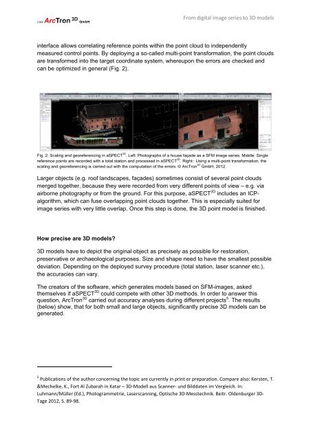
interface allows correlating reference points within the point cloud <strong>to</strong> independently<br />
measured control points. By deploying a so-called multi-point transformation, the point clouds<br />
are transformed in<strong>to</strong> the target coordinate system, whereupon the errors are checked and<br />
can be optimized in general (Fig. 2).<br />
Fig. 2: Scaling and georeferencing in aSPECT <strong>3D</strong> . Left: Pho<strong>to</strong>graphs of a house façade as a SFM <strong>image</strong> <strong>series</strong>. Middle: Single<br />
reference points are recorded with a <strong>to</strong>tal station and processed in aSPECT <strong>3D</strong> . Right:: Using a multi-point transformation, the<br />
scaling and georeferencing is carried out with the computation of the errors. © ArcTron <strong>3D</strong> GmbH, 2012.<br />
Larger objects (e.g. roof landscapes, façades) sometimes consist of several point clouds<br />
merged <strong>to</strong>gether, because they were recorded from very different points of view – e.g. via<br />
airborne pho<strong>to</strong>graphy or from the ground. For this purpose, aSPECT <strong>3D</strong> includes an ICPalgorithm,<br />
which can fuse overlapping point clouds <strong>to</strong>gether. This is especially suited for<br />
<strong>image</strong> <strong>series</strong> with very little overlap. Once this step is done, the <strong>3D</strong> point model is finished.<br />
How precise are <strong>3D</strong> <strong>models</strong>?<br />
<strong>3D</strong> <strong>models</strong> have <strong>to</strong> depict the original object as precisely as possible for res<strong>to</strong>ration,<br />
preservative or archaeological purposes. Size and shape need <strong>to</strong> have the smallest possible<br />
deviation. Depending on the deployed survey procedure (<strong>to</strong>tal station, laser scanner etc.),<br />
the accuracies can vary.<br />
The crea<strong>to</strong>rs of the software, which generates <strong>models</strong> based on SFM-<strong>image</strong>s, asked<br />
themselves if aSPECT <strong>3D</strong> could compete with other <strong>3D</strong> methods. In order <strong>to</strong> answer this<br />
question, ArcTron <strong>3D</strong> carried out accuracy analyses during different projects 5 . The results<br />
(below) show, that for both small and large objects, significantly precise <strong>3D</strong> <strong>models</strong> can be<br />
generated.<br />
5<br />
Publications of the author concerning the <strong>to</strong>pic are currently in print or preparation. Compare also: Kersten, T.<br />
&Mechelke, K., Fort Al Zubarah in Katar – <strong>3D</strong>-Modell aus Scanner- und Bilddaten im Vergleich. In:<br />
Luhmann/Müller (Ed.), Pho<strong>to</strong>grammetrie, Laserscanning, Optische <strong>3D</strong>-Messtechnik. Beitr. Oldenburger <strong>3D</strong>-<br />
Tage 2012, S. 89-98.