

Tauroa Point Dune Middens heritage assessement - Department of ...
Tauroa Point Dune Middens heritage assessement - Department of ...
Tauroa Point Dune Middens heritage assessement - Department of ...

Create successful ePaper yourself
Turn your PDF publications into a flip-book with our unique Google optimized e-Paper software.
<strong>Tauroa</strong> <strong>Point</strong> <strong>Dune</strong> <strong>Middens</strong><br />
Heritage Assessment<br />
1<br />
Jonathan Carpenter<br />
Geometria Ltd<br />
June 2012
2<br />
Contents<br />
Site Overview ......................................................................................................................................................................................... 3<br />
History Description .............................................................................................................................................................................7<br />
Fabric Description............................................................................................................................................................................... 8<br />
Cultural Connections ...................................................................................................................................................................... 14<br />
National Context Sources ............................................................................................................................................................ 14<br />
Historic Significance ....................................................................................................................................................................... 15<br />
Fabric Significance ........................................................................................................................................................................... 15<br />
Cultural Significance ....................................................................................................................................................................... 15<br />
Management Recommendations ............................................................................................................................................. 15<br />
Management Chronology ............................................................................................................................................................ 16<br />
Management Documentation .................................................................................................................................................... 17<br />
Sources ..................................................................................................................................................................................................... 17<br />
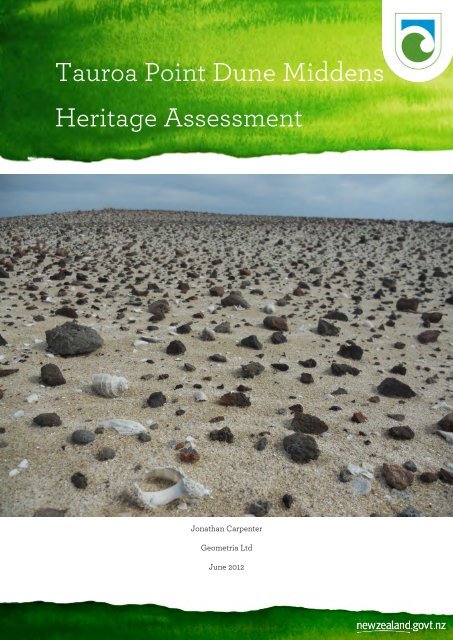
Cover Image: Completely deflated scatter <strong>of</strong> shell and oven stones, probably recorded as archaeological site N05/322<br />
or 223.
Site Overview<br />
3<br />
The <strong>Tauroa</strong> <strong>Point</strong> dune middens are located on the western side <strong>of</strong> the Ahipara Conservation<br />
Area, west <strong>of</strong> Ahipara at the southern end <strong>of</strong> 90 Mile Beach/Oneroa. The Conservation Area is<br />
3484ha in size and the midden are scattered around the foredunes between the coast and the<br />
higher ground which rises to the Ahipara Plateau. The reserve is accessible either side <strong>of</strong> low tide<br />
by 4WD vehicle across the 19 ha <strong>Tauroa</strong> <strong>Point</strong> Conservation Area (which also contains a number<br />
<strong>of</strong> midden). That Conservation Area consists <strong>of</strong> a narrow strip <strong>of</strong> land between the sea and the<br />
foredunes around the rocky wave platform <strong>of</strong> Shipwreck Bay and the beachfront to the southwest.<br />
The two conservation areas contain more than fifty recorded sites but due to the environment,<br />
shifting sands regularly cover and/or erode and destroy previously recorded sites and uncover<br />
new ones. Midden are also affected by ongoing erosion from streams and storm events, as well as<br />
stock trampling and 4WD vehicles. In addition to the midden there are several pa and terrace<br />
sites located on the two Conservation Areas, and several patches <strong>of</strong> taro and historic house sites.<br />
A map <strong>of</strong> the known site locations and the other sites in the Conservation Area has been<br />
produced by digitising marked up NZMS 260 metric topographic maps prepared by DOC<br />
Historic staff for sites on the DOC estate, based on the original site records. The locations shown<br />
here are more accurate than those in ArchSite (which require updating). They have been overlaid<br />
in a Geographic Information System along with recent aerial imagery and other geographic data;<br />
the location <strong>of</strong> features is approximate only but provides a picture <strong>of</strong> the archaeological features<br />
in the context <strong>of</strong> the surrounding landscape (Figure 1-3).
Figure 1: <strong>Tauroa</strong> <strong>Point</strong> Conservation Area (northern end).<br />
4
Figure 2: <strong>Tauroa</strong> <strong>Point</strong> Conservation Area (central part).<br />
5
Figure 3: <strong>Tauroa</strong> <strong>Point</strong> Conservation Area (southern end).<br />
6
History Description<br />
7<br />
Archaeological investigations indicate that the <strong>Tauroa</strong> dunes were occupied or at least visited as<br />
early as 1220-1390 AD based on radiocarbon dates from an earth oven at site N05/302. The<br />
Polynesian ancestors <strong>of</strong> the Maori probably made use <strong>of</strong> the area to collect seafood from the<br />
rocky shoreline and beyond, attracted by the fresh water available from the nearby stream and<br />
the break or channel in the rocks on the shore opposite. As well as fish and shellfish, seals, dogs,<br />
bird and whale were also represented in the food remains. The nearby environment was<br />
characterised by kanuka, pohutakawa, cassinia and akeake which provided fuels for the camp<br />
fires. As well as hunting and fishing, the inhabitants worked bone to make fish hooks. Obsidian<br />
flakes found in the site have been sourced to Mayor Island in the Bay <strong>of</strong> Plenty and other stone<br />
tools came from sources at Houhora and Herekino. Burials found on the other side <strong>of</strong> the stream<br />
at N05/301 suggested the occupation was long enough to necessitate the burial <strong>of</strong> several people<br />
nearby.<br />
The dates are as early as any in New Zealand suggesting the area may have been one <strong>of</strong> the first<br />
settled or otherwise utilised. At the same time, similar camps were established at Tom Bowling<br />
Bay/Kapowairua and Twilight Beach near Cape Reinga, and a substantial village was located at<br />
Mt Camel at Houhora.<br />
The area continued to be occupied or utilised after the original settlement with several major<br />
changes over time. After 1400 there was no tool or fish hook making on-site and few artefacts<br />
were left. There was more emphasis on collecting shellfish and less on fishing, suggesting more<br />
fleeting visits for the purpose <strong>of</strong> shellfish gathering rather than a longer term and/or more<br />
general occupation. After 1600 the large communal ovens vanish from the archaeological record,<br />
as does evidence for sea mammal and bird butchery. Pohutakawa disappears from the charcoal<br />
record, suggesting even this otherwise hardy and fire-tolerant species had become rare on the<br />
coast,<br />
Te Aupouri were the inhabitants <strong>of</strong> the area in the 17 th and early 18 th century. Te Aupouri, first<br />
known as Ngati Ruanui, originally landed at the Hokianga on the Mamari canoe. They settled on<br />
the north shore <strong>of</strong> the harbour and ultimately extended as far as Whangape. After coming into<br />
conflict with people already resident at Whangape and Mitimiti, a series <strong>of</strong> tragic events<br />
culminated in 1824 1 when Te Aupouri fought Ngapuhi, Te Rarawa and Ngati Kahu under Hongi<br />
Hika <strong>of</strong> Ngapuhi and Nopera Panakaraeo <strong>of</strong> Te Rarawa at Hukatere Hill on 90 Mile Beach. Te<br />
Aupouri were outnumbered and retreated east to Houhoura and then north to the centre <strong>of</strong> their<br />
rohe fighting a number <strong>of</strong> rear-guard actions. This led to the iwi taking on the name <strong>of</strong> Te<br />
Aupouri and moving north, via Herekino, Ahipara, and Pukepoto, to Te Kao. Here they were<br />
given the pa Tawhitirahi (Te Kao Pa) by their Ngai Takoto relatives and Te Kao, named after the<br />
local process used to dry and preserve kumara, is still the heart <strong>of</strong> Te Aupouri (Cloher 2002). Te<br />
Rarawa subsequently settled the land around <strong>Tauroa</strong> <strong>Point</strong>.<br />
Te Rarawa emphasise descent from the Tinana canoe, captained by Tūmoana. Tūmoana's<br />
descendants spread throughout the northern Hokianga and eastward to Maunga Taniwha.<br />
1<br />
Crosby (1999: 150-153) puts the battle in this year; Metge (2002) notes tribal experts putting it one to two<br />
years later.
8<br />
Tūmoana later returned to Hawaiki, leaving his son Tamahotu and daughter Kahutianui-o-terangi<br />
at <strong>Tauroa</strong>. Te Rarawa also trace descent from the canoes Matawhaorua, captained by Kupe,<br />
Kurahaupō, captained by Pōhurihanga, Ngātokimatawhaorua, captained by Nukutawhiti and<br />
Māhuhu-ki-te-rangi, captained by Rongomai and Whakatau.<br />
The Te Rarawa chief Panakaraeo who bested Te Aupouri at Hukatere Hill welcomed the first<br />
missionaries to the area and supported European settlement for the economic benefits to his<br />
lands and people. He signed the Treaty <strong>of</strong> Waitangi, although he became increasingly<br />
disillusioned as government purchases after the treaty saw the loss <strong>of</strong> 131,000ha between 1840<br />
and 1865 on top <strong>of</strong> the 60,000ha <strong>of</strong> pre-treaty purchases subsequently confirmed and granted by<br />
the Crown.<br />
By 1865, the land from Ahipara south to the Whangape Harbour and including <strong>Tauroa</strong> <strong>Point</strong> was<br />
the only Maori land in Muriwhenua untouched by European land purchases. From 1870 the<br />
purchase <strong>of</strong> land in the area was given impetus by Julius Vogel during the Fox Ministry, under<br />
the Immigration and Public Works Acts <strong>of</strong> 1870 and 1873, and the Native Land Act <strong>of</strong> 1873.<br />
Between 1872 and 1879 three government land agents purchased 64,000 acres including the<br />
10,500 acre Te <strong>Tauroa</strong> Block and the 1600 acre Epakauri Block in March 1877, for £175 and £27<br />
respectively.<br />
The Waitangi Tribunal’s Muriwhenua Land Report (1992: 312) states:<br />
“In the district from Ahipara to Herekino…what was left <strong>of</strong> Maori land from the 1877<br />
sale <strong>of</strong> the <strong>Tauroa</strong> and Epakauri Blocks was probably the poorest in Muriwhenua. The<br />
Waitaha native reserve on the coast 2 , and the northern aspects <strong>of</strong> Herekino Harbour,<br />
which were still in Maori lands, included large sand dune areas. The balance <strong>of</strong> the<br />
Maori land was hillyu, in forest and scrub. It was later to be devastated by gumdigging<br />
and the removal <strong>of</strong> the millable timber. Attempts to establish farms there in the 1930s<br />
were unsuccessful: they were abandoned by the 1960s and reverted to scrub.”<br />
The lands on the Ahipara Plateau and the coastal dunes were unsuited to farming, the latter<br />
previously being covered in kauri forest, leached <strong>of</strong> its nutrients then cut over by sawyers, and<br />
later thoroughly worked over by gum diggers. Farm development was possible only on the lower<br />
land in the immediate vicinity <strong>of</strong> Ahipara. In 1901 much <strong>of</strong> the crown land was gazetted as kauri<br />
gum reserves and the Ahipara Plateau became a thriving gum digging community for a time,<br />
before kauri gum was replaced as a valuable commodity (Ibid: 355, 379).<br />
Fabric Description<br />
Site recording at <strong>Tauroa</strong> <strong>Point</strong> began in the early 1970s when the first dune midden site there was<br />
recorded by L. Knott as part <strong>of</strong> her university coursework in 1974. However the earliest sites<br />
recorded in the area were four pa and a terrace complex recorded by C. and R. Lawn on the<br />
Ahipara Plateau between Shipwreck Bay and the Hukatere and Hanuhanu Streams in 1971. Leahy<br />
and Walsh (1979) undertook the earliest systematic survey in the area on behalf <strong>of</strong> the Historic<br />
Places Trust, focussing on the coast and hinterland between <strong>Tauroa</strong> <strong>Point</strong> and Herekino. The<br />
next major survey was undertaken by L. Johnson in 1989 for the <strong>Department</strong> <strong>of</strong> Conservation.<br />
2 At the southern end <strong>of</strong> the reserve at Waitaha Stream.
9<br />
The parlous state <strong>of</strong> a number <strong>of</strong> apparently early or otherwise significance sites identified by<br />
Johnson at <strong>Tauroa</strong> <strong>Point</strong> led to archaeological investigations by DOC staff in 1991 and DOC and<br />
a University <strong>of</strong> Auckland archaeology Field School in 2003. The excavations in the 1990s have<br />
only been partially reported (Johnson n.d.) while the most recent excavation results have been<br />
reported on or published in Allen (2006a and 2006b), Allen et. al. (2005), and Wichman 2006.<br />
There are eleven sites recorded on or in the immediate vicinity <strong>of</strong> the <strong>Tauroa</strong> <strong>Point</strong> Conservation<br />
Area including five midden, five taro patches and a historic house site. Between the northern end<br />
<strong>of</strong> the Ahipara Conservation Area where it abuts the <strong>Tauroa</strong> <strong>Point</strong> Conservation Area and the<br />
Okura Stream there are ten recorded midden and eight stone working areas, with a pa site and<br />
several stone working sites recorded on the adjacent privately owned farm.<br />
The dunes between the Okura and Tanutanu Streams have advanced up to 4km to the north-west<br />
from the west coast. There are eleven midden recorded along this section <strong>of</strong> the coast along with<br />
15 stone scatters and two terraces or house sites. There are also six pa or terraced ridgelines on<br />
the northern boundary <strong>of</strong> the Ahipara Conservation Area on high ground overlooking Ahipara,<br />
in areas not yet reclaimed by the sand.<br />
Between the Tanutanu Stream and the southern end <strong>of</strong> the Ahipara Conservation Area just north<br />
<strong>of</strong> the Hunahuna Stream there are eight midden (two <strong>of</strong> which lie in the Waitaha Maori land<br />
block which is surrounded by the Conservation Area) and a stone scatter. Two kilometres inland<br />
on the high ground above the Tanutanu Stream are two sites recorded as pits and terraces with<br />
Maungatapere Pa. Another three pa are recorded on the Conservation Area on the high ground<br />
above the Hunahuna Stream.<br />
The midden tend to be nearer the coast and the stone scatters are further inland. Most <strong>of</strong> the sites<br />
are within 500m <strong>of</strong> the coast although there are several further north towards the centre <strong>of</strong> the<br />
dunes. Sites cluster around the stream valleys, with midden, ovens and working floors on the<br />
foredunes 20-60m above the high tide line, and village and pa sites, represented by complexes <strong>of</strong><br />
terraces, pits and defensive works, further up the valleys on the higher ground. Cultivation<br />
probably occurred on the valley floors. In contrast the gum lands on the Ahipara Plateau contain<br />
few archaeological sites apart from those associated with more recent timber extraction and gum<br />
digging. This settlement pattern was noted by Mckay (1982) in her archaeological assessment for<br />
the Ahipara Land Use Study.<br />
Most <strong>of</strong> the midden are from the mid to late pre-historic or proto-historic “Classic” period <strong>of</strong><br />
Maori occupation and contain predominantly tuatua shell, fire cracked rock and charcoal with<br />
some fish bone. A few <strong>of</strong> the sites including those excavated by DOC staff in 1991-92 (sites<br />
N05/301 at the small stream north <strong>of</strong> Okura Creek) and DOC and the University <strong>of</strong> Auckland<br />
archaeology field school in 2003 (sites N05/302 opposite N05/301, and N05/314 at Okura Creek)<br />
contained material from the “Archaic” period <strong>of</strong> occupation by the Polynesian ancestors <strong>of</strong> the<br />
Maori. The archaic sites include fish and shellfish and oven material but also contain a range <strong>of</strong><br />
bird and mammal bone (whale, seal, dog) and a greater range <strong>of</strong> artefactual material including<br />
non-local stone tools and production waste. The stone scatters are areas where stone tools made<br />
from obsidian, chert or other usually exotic stones were worked, and/or collections <strong>of</strong> whole or<br />
fire-cracked cobbles from hearths where all the other associated archaeological material has been<br />
completely destroyed/dispersed and only the hardy oven stones remain.
Figure 4: N05/301, excavated in 2003.<br />
Figure 5: Excavated section <strong>of</strong> N05/301.<br />
10
Figure 6: N05/302, excavated in 2003.<br />
Figure 7: Partially deflated hearth on N05/302.<br />
11
Figure 8: Fencing and vehicle tracks, N05/302.<br />
Figure 9: Midden with servicable fencing, probably part <strong>of</strong> N03/322 or 323.<br />
12
Figure 10: Completely deflated scatter <strong>of</strong> shell and oven stones probably N05/322 or 223.<br />
Figure 11: Stratified midden in eroding dune.<br />
13
Cultural Connections<br />
The <strong>Tauroa</strong> <strong>Point</strong> dune middens are in the rohe <strong>of</strong> Te Rarawa.<br />
14<br />
Te Rarawa became the dominant iwi between Ahipara and Herekino after forcing Te Aupouri<br />
northwards in the late 18 th and early 19 th century. This culminated in the battle <strong>of</strong> Hukatere Hill<br />
north <strong>of</strong> Ahipara where Te Aupouri were comprehensively defeated by Te Rarawa who were<br />
allied with Ngapuhi.<br />
National Context Sources<br />
There is no national context source available in order to provide a comprehensive basis for<br />
assessing the national (representative) significance <strong>of</strong> the <strong>Tauroa</strong> <strong>Point</strong> dune middens. However<br />
there are general references for midden including those by Davidson (1982, 1984). Welsh (2008)<br />
has provided an overview <strong>of</strong> middens in dune sites which is a useful summary <strong>of</strong> their values,<br />
and the various reports on the Southland Coastal Heritage Inventory Project, undertaken by<br />
South Pacific Archaeological Research (SPAR) supported by the DOC Southland Conservancy,<br />
Environment Southland, the Murihiku rununga, NZ Historic Places Trust and NZ Archaeological<br />
Association, provides a useful approach to valuing and managing coastal midden sites (SPAR<br />
2007, 2008, 2011).<br />
L. Furey has also produced a Northland Archaeological Resource Statement which summarises<br />
the archaeology <strong>of</strong> the region, its values, and the threats that it faces, for the <strong>Department</strong> <strong>of</strong><br />
Conservation. This document remains in draft form and limited circulation, however section 10.2<br />
<strong>of</strong> the document discusses dune midden including the <strong>Tauroa</strong> <strong>Point</strong> sites in some detail and<br />
concludes the section by stating that:<br />
“dune areas indicates that an important site type is disappearing rapidly, with<br />
significant loss <strong>of</strong> information about how people used the coastal resources through<br />
time. These sites span the full period <strong>of</strong> Maori settlement, and into the historic period<br />
as European items such as clay pipes and bottle glass have been found in association<br />
with more traditional materials in some sites. The main emphasis has been on the<br />
large areas <strong>of</strong> dunefields, but other beaches and bays also have eroding sites which<br />
warrant attention, either in rescue archaeology or in protection. There needs to be a<br />
well-thought out and comprehensive research programme implemented to recover<br />
information from dunes in the very near future. It is apparent from archaeological<br />
assessments over 40 years, and from artefact collections made in the early part <strong>of</strong> the<br />
20th century, that some <strong>of</strong> these areas have been eroding for some time.<br />
Archaeological sites are a finite resource, and the amount <strong>of</strong> intact material left is<br />
reducing all the time” (Furey n.d.: Section 10.2).<br />
In her general conclusions, Furey states that:<br />
“A project <strong>of</strong> recording and recovering information from sand dunes in the north is a<br />
high priority, and is <strong>of</strong> national significance. The case study on dune sites has<br />
highlighted the vulnerability <strong>of</strong> these sites, and the destruction <strong>of</strong> information about<br />
the early period <strong>of</strong> settlement <strong>of</strong> New Zealand. A research project could address<br />
settlement in Northland in the early period with implications for understanding stone
15<br />
technology, trade, communication and resource use (discovery <strong>of</strong> geological resources)<br />
(Furey n.d.: Section 11.0).<br />
Historic Significance<br />
There are no historic events or personalities associated with <strong>Tauroa</strong> <strong>Point</strong> dune midden. While<br />
the late prehistoric or classic period midden are relatively ubiquitous the early or archaic midden,<br />
containing evidence for the earliest occupation <strong>of</strong> New Zealand, are highly significant for the<br />
information they can provide about the social organisation and subsistence strategies and<br />
material culture <strong>of</strong> New Zealands earliest inhabitants.<br />
Fabric Significance<br />
The <strong>Tauroa</strong> <strong>Point</strong> dune middens are largely late prehistoric and protohistoric midden consisting<br />
mainly <strong>of</strong> shellfish, fire-cracked rock and charcoal. Many <strong>of</strong> the midden are deflated or lagged<br />
deposits where the sand from beneath and around the archaeological material has been removed<br />
by the action <strong>of</strong> the wind leaving a scatter <strong>of</strong> archaeological material. Although this is out <strong>of</strong> its<br />
primary context and is potentially a palimpsest <strong>of</strong> material from different periods, it still contains<br />
information that can be retrieved by archaeological investigation.<br />
Cultural Significance<br />
The <strong>Tauroa</strong> <strong>Point</strong> dune middens are <strong>of</strong> high significance to Te Rarawa and Roma Marae, who are<br />
the kaitiaki <strong>of</strong> the sites. Given the early dates for some <strong>of</strong> the sites, other iwi formerly resident in<br />
the area such as Te Aupouri, or their ancestors, may also have connections with the sites.<br />
Management Recommendations<br />
The <strong>Tauroa</strong> <strong>Point</strong> dune middens exist in an exceedingly dynamic environment beset by coastal<br />
geomorphological forces which are exacerbated by human-induced impacts, chiefly 4WD activity<br />
and stock trampling via unserviceable farm fences.<br />
Monitoring and Re-survey<br />
Currently informal monitoring <strong>of</strong> the dune middens occurs during trips by Kaitaia Area historic<br />
staff three or four times a year. It would be appropriate to undertake more formal monitoring four<br />
times a year, including the establishment <strong>of</strong> photo points and photo monitoring on critical sites<br />
and recording new exposures as they are identified.<br />
Given that almost twenty years has elapsed since the last survey <strong>of</strong> sites in the dunes it would be<br />
useful to undertake another intensive survey to re-record known sites, identify recently exposed<br />
sites, make management recommendations and identify significant sites for further<br />
investigation, in the short to medium term. This also fits with the <strong>Department</strong> <strong>of</strong> Conservation’s<br />
undertaking to complete the NZ Archaeological Association Site Recording upgrade on the DOC<br />
estate.
16<br />
The results <strong>of</strong> the re-survey could be used to leverage a more intensive investigation as proposed<br />
by Furey and which is currently occurring with DOC support in Southland.<br />
Fencing and 4WD Management<br />
The Kaitaia Area has developed a good working relationship with members <strong>of</strong> the local 4WD<br />
club who, along with the Tangata Whenua, are the most regular users <strong>of</strong> dunes (and which, apart<br />
from natural erosion, have the greatest potential impact on the dune midden). The 4WD club<br />
members undertake ad-hoc repairs to the existing fencing and have undertaken several more<br />
formal fencing projects in 2001 and 2007.<br />
DOC should continue to support the fencing effort.<br />
Interpretation<br />
There is no detailed information about the dune middens available on the internet, apart from<br />
visitor information. On-site signage refers generally to the archaeological/historic sites present<br />
in the area, their fragility and significance. The signage does not talk about specific sites or site<br />
locations or contents in order to prevent fossicking. It would be appropriate to make the general<br />
results <strong>of</strong> the archaeological investigations available to the public along with general comments<br />
about dune midden.<br />
This Heritage Assessment and other public documents such as the results <strong>of</strong> the previous<br />
investigations should be made available on the DOC website.<br />
Management Chronology<br />
1877 <strong>Tauroa</strong> Block and Epakauri Block purchased by the Crown.<br />
1901 Ahipara Kauri Gum Reserve gazetted by the Crown.<br />
1989-90 Archaeological survey <strong>of</strong> <strong>Tauroa</strong> <strong>Point</strong> dunes records more than a dozen sites along<br />
10km coastline for the Ahipara Gumfields Stewardship Management Plan. Plane table<br />
and alidade drawing <strong>of</strong> N05/302 undertaken.<br />
1991-1992 First rescue excavation on the largest midden 7km south <strong>of</strong> Reef <strong>Point</strong>, at Tairua <strong>Point</strong>,<br />
N05/314 and N05/323.<br />
1998 Re-vegetation project in cooperation with Peter Woods <strong>of</strong> Ag Research begins.<br />
2001 HAMS costed remedial specification for dune midden developed. First protective fencing<br />
<strong>of</strong> midden established.<br />
2002 Burials noted at N05/301 exposed by stock.<br />
2003 University <strong>of</strong> Auckland archaeological field school excavation.<br />
2006-7 4WD Club repair fences. Discussion <strong>of</strong> sourcing funding for a management plan for the<br />
sites.
17<br />
2007 <strong>Tauroa</strong> <strong>Point</strong> Visitor Survey undertaken by DOC concludes that midden fencing has<br />
been effective in defining sites and reducing unintentional visitor impacts, although<br />
stock encroachment was still causing problems. Visitors also desired more information<br />
about the sites.<br />
Management Documentation<br />
<strong>Tauroa</strong> <strong>Point</strong> Midden. AMHP 15. HAMS costed specification.<br />
Sources<br />
HHA-01-01-12. <strong>Tauroa</strong> <strong>Point</strong>. <strong>Department</strong> <strong>of</strong> Conservation, Kaitaia Area Office.<br />
Allen., M. S., 2006a. Blowing in the Wind: Rescue Excavations at Site N05/302, <strong>Tauroa</strong> <strong>Point</strong>,<br />
Ahipara, Northland. Archaeology in New Zealand 49 (2): 105-119.<br />
Allen, M. S., 2006b. Periodicity, Duration, and Function <strong>of</strong> Occupation at <strong>Tauroa</strong> <strong>Point</strong>,<br />
Northland, New Zealand. New Zealand Journal <strong>of</strong> Archaeology Vol. 27: 19-62.<br />
Allen, M. S., R. Wallace, H. Bader and D. Parker, 2005. Archaeological investigations. <strong>Tauroa</strong><br />
<strong>Point</strong>, Ahipara, Northland: 2003 archaeological field school, University <strong>of</strong> Auckland.<br />
Unpublished report by the Anthropology <strong>Department</strong>, Univesrity <strong>of</strong> Auckland, Auckland.<br />
Beauchamp, T., R. Garrard, A. Gordon, S. Mathews, and C. Smith 2007. <strong>Tauroa</strong> <strong>Point</strong> visitors<br />
survey. <strong>Department</strong> <strong>of</strong> Conservation, Northland Conservancy, Whangarei.<br />
Davidson, J., 1982. Northland. In N. J. Prickett (ed.) The First Thousand Years: Regional<br />
Perspectives in New Zealand Archaeology. New Zealand Archaeological Association<br />
Monograph 13. Palmerston North: Dunmoore Press, pp. 11-27.<br />
Davidson, J., 1984. The Prehistory <strong>of</strong> New Zealand. Longman Paul, Auckland.<br />
Furey, L., n.d. Northland archaeological resource statement. Unpublished draft report for the<br />
<strong>Department</strong> <strong>of</strong> Conservation.<br />
Johnson, L. n.d.: Preliminary report on the excavation <strong>of</strong> site N5/301, <strong>Tauroa</strong> <strong>Point</strong> Ahipara.<br />
Unpublished report for the <strong>Department</strong> <strong>of</strong> Conservation, Whangarei.<br />
Littleton, J., 2003. <strong>Tauroa</strong> Bay, Ahipara – The burials at site 301. Unpublished report for Te Aroha<br />
and the <strong>Department</strong> <strong>of</strong> Conservation. Anthropology <strong>Department</strong>, University <strong>of</strong> Auckland,<br />
Auckland.<br />
McKay, J., 1982. Ahipara land use study. Archaeological Assessment. Unpublished report for the<br />
Lands and Survey <strong>Department</strong>.<br />
Phillips, R., 2003. Sourcing the lithics <strong>of</strong> <strong>Tauroa</strong> <strong>Point</strong>. Unpublished archaeology field school<br />
report for the Anthropology <strong>Department</strong>, University <strong>of</strong> Auckland.<br />
Slocombe., A., 1999-2001. Stabilisation <strong>of</strong> archaeological sites at <strong>Tauroa</strong> <strong>Point</strong>, Ahipara.<br />
Unpublished file note. <strong>Department</strong> <strong>of</strong> Conservation, Kaitaia Area Office.
18<br />
SPAR, 2007. Southland coastal <strong>heritage</strong> inventory project. Stage I: Waikawa to Omaui.<br />
Unpublished report for <strong>Department</strong> <strong>of</strong> Conservation, Environment Southland, Kaitiaki<br />
Runaka o Murihiku, NZ Historic Places Trust and New Zealand Archaeological<br />
Association. South Pacific Archaeological Research, <strong>Dune</strong>din.<br />
SPAR, 2008. Southland coastal <strong>heritage</strong> inventory project: Waiparau Head to Rowallan Burn.<br />
Unpublished report for <strong>Department</strong> <strong>of</strong> Conservation, Environment Southland, Kaitiaki<br />
Runaka o Murihiku, NZ Historic Places Trust and New Zealand Archaeological<br />
Association. South Pacific Archaeological Research, <strong>Dune</strong>din.<br />
SPAR, 2011. Interim report on archaeological investigations at the Tokanui River mouth (F47/11,<br />
F47/51, F47/53) carried out under Authority 2011-232. Unpublished report for <strong>Department</strong><br />
<strong>of</strong> Conservation, Environment Southland, Kaitiaki Runaka o Murihiku, NZ Historic<br />
Places Trust and New Zealand Archaeological Association. South Pacific Archaeological<br />
Research, <strong>Dune</strong>din.<br />
Welch, J., 2008. Where have all the moa bones gone. The archaeology <strong>of</strong> dune environments.<br />
Paper presented at the 2008 <strong>Dune</strong> Restoration Trust conference, Whanganui.<br />
http://www.dunestrust.org.nz/mar08conf/JonathanWelch.pdf.<br />
Wichman, V. L., 2006. Prehistoric fishing at <strong>Tauroa</strong> <strong>Point</strong>, New Zealand. Unpublished MA thesis.<br />
University <strong>of</strong> Auckland.


