Understanding weather - fronts, troughs and ridges - NSW ...
Understanding weather - fronts, troughs and ridges - NSW ...
Understanding weather - fronts, troughs and ridges - NSW ...
You also want an ePaper? Increase the reach of your titles
YUMPU automatically turns print PDFs into web optimized ePapers that Google loves.
MAY 2007 PRIMEFACT 608 (REPLACES AGNOTE ET-11) UNDERSTANDING WEATHER<br />
<strong>Underst<strong>and</strong>ing</strong> <strong>weather</strong> – <strong>fronts</strong>, <strong>troughs</strong><br />
<strong>and</strong> <strong>ridges</strong><br />
Paul Carberry<br />
Advisory Officer Climatology, Extensive Industries<br />
Development, Tamworth<br />
Fronts<br />
A front is the boundary between two air masses of<br />
different temperatures. It may be moving, in which<br />
case the front is named for the advancing air mass,<br />
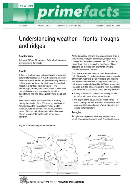
cold or warm, or it may be stationary. A simplified<br />
model of a front is shown in figure 1. The<br />
advancing air mass, cold in this case, pushes into<br />
the existing air mass, causing the air at the<br />
boundary to rise <strong>and</strong> consequently form cloud <strong>and</strong><br />
rain.<br />
This classic model was developed in Norway<br />
during the middle of the 20th century <strong>and</strong> is often<br />
referred to as the Norwegian Frontal Model.<br />
Although cold <strong>fronts</strong> often can be described in<br />
terms of this model, observational studies have<br />
shown many frontal systems to be far more<br />
complex.<br />
Figure 1. The Norwegian Frontal Model<br />
At the boundary, or front, there is a marked drop in<br />
temperature, increase in humidity, sudden wind<br />
change <strong>and</strong> a marked pressure rise. This marked<br />
discontinuity lends support to the theory of two<br />
separate air masses with the front being the<br />
boundary between the two.<br />
Cold <strong>fronts</strong> are more relevant over the southern<br />
half of Australia. This classic picture occurs in parts<br />
of Western Australia, South Australia <strong>and</strong> Victoria<br />
<strong>and</strong> in New South Wales during winter <strong>and</strong> spring<br />
but seldom applies in New South Wales in summer.<br />
Features that can cause variations from the classic<br />
case include the properties of the existing air mass:<br />
• it may not be moist or unstable enough to form<br />
cloud or rain even when forced to rise<br />
• the depth of the advancing air mass varies – in<br />
<strong>NSW</strong> during summer it is often very shallow <strong>and</strong><br />
can result in just a change of wind direction <strong>and</strong><br />
a drop in temperature.<br />
Troughs<br />
Troughs are regions of relatively low pressure<br />
which often precede a cold front. A dashed line on
Figure 2. Cold front, prefrontal trough <strong>and</strong> high pressure ridge<br />
the <strong>weather</strong> map indicates the location of a weak<br />
pressure trough. These <strong>troughs</strong> form during the<br />
warmer months of the year over the southern part<br />
of the Australian continent <strong>and</strong> waters to the south.<br />
Troughs have the potential to intensify rapidly,<br />
generally at the expense of the cold front, resulting<br />
in strengthening of the northerly winds ahead of a<br />
cool change. In summer the major significant wind<br />
change is associated with prefrontal <strong>troughs</strong>.<br />
Figure 2 shows a cold front <strong>and</strong> prefrontal trough<br />
through SA <strong>and</strong> Victoria. An easterly dip (not shown<br />
here – see What drives <strong>NSW</strong> <strong>weather</strong>?) is a<br />
specific type of inl<strong>and</strong> trough that extends into<br />
<strong>NSW</strong> from Queensl<strong>and</strong>. These areas of relatively<br />
low pressure are unstable <strong>and</strong> tend to have high<br />
moisture associated with them. Consequently, they<br />
are good sources of thunderstorms.<br />
Ridges<br />
A ridge is a line of relatively high pressure forming<br />
an arm out of a defined high, but not forming a<br />
closed loop. Figure 2 shows a ridge pushing out<br />
into South Australia from the high positioned below<br />
Perth.<br />
Ridges, being areas of high pressure, generally<br />
result in dry conditions in their immediate vicinity.<br />
A high pressure ridge may be associated with<br />
coastal showers when it brings onshore winds<br />
along the east coast in advance of the ridge itself.<br />
These onshore winds can produce widespread<br />
coastal showers.<br />
The zone of interaction of the ridge with nearby<br />
areas of low pressure or <strong>troughs</strong> can be unstable<br />
<strong>and</strong> produce storms or rain in any area.<br />
© State of New South Wales through <strong>NSW</strong> Department of<br />
Primary Industries 2007. You may copy, distribute <strong>and</strong><br />
otherwise freely deal with this publication for any purpose,<br />
provided that you attribute <strong>NSW</strong> Department of Primary<br />
Industries as the owner.<br />
ISSN 1832-6668<br />
Replaces Agnote ET-11<br />
Check for updates of this Primefact at:<br />
www.dpi.nsw.gov.au/primefacts<br />
Disclaimer: The information contained in this publication is<br />
based on knowledge <strong>and</strong> underst<strong>and</strong>ing at the time of writing<br />
(May 2007). However, because of advances in knowledge,<br />
users are reminded of the need to ensure that information<br />
upon which they rely is up to date <strong>and</strong> to check currency of<br />
the information with the appropriate officer of New South<br />
Wales Department of Primary Industries or the user’s<br />
independent adviser.<br />
Job number 7751<br />
PRIMEFACT 608, UNDERSTANDING WEATHER - FRONTS, TROUGHS AND RIDGES 2


