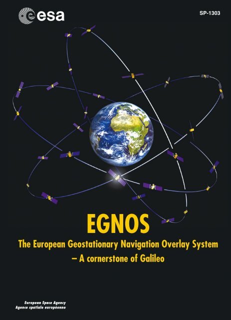
EGNOS The European Geostationary Navigation Overlay ... - ESA
EGNOS The European Geostationary Navigation Overlay ... - ESA
EGNOS The European Geostationary Navigation Overlay ... - ESA

You also want an ePaper? Increase the reach of your titles
YUMPU automatically turns print PDFs into web optimized ePapers that Google loves.
SP-1303<br />
<strong>EGNOS</strong><br />
<strong>The</strong> <strong>European</strong> <strong>Geostationary</strong> <strong>Navigation</strong> <strong>Overlay</strong> System<br />
– A cornerstone of Galileo
<strong>EGNOS</strong><br />
SP-1303<br />
December 2006<br />
<strong>The</strong> <strong>European</strong> <strong>Geostationary</strong> <strong>Navigation</strong> <strong>Overlay</strong> System<br />
– A cornerstone of Galileo<br />
Technical Editors:<br />
Javier Ventura-Traveset (<strong>ESA</strong>)<br />
Didier Flament (Alcatel Alenia Space)
This book is dedicated to the memory of Jean-Pierre Dupont, who worked in the <strong>ESA</strong><br />
<strong>EGNOS</strong> Project Office from 1996 to 2005, who was much respected by the <strong>EGNOS</strong> Project<br />
Team, and who contributed greatly to the consolidation of the <strong>EGNOS</strong> mission and its<br />
performance.<br />
Publication: <strong>The</strong> <strong>European</strong> <strong>EGNOS</strong> Project<br />
(<strong>ESA</strong> SP-1303)<br />
Published and distributed by: <strong>ESA</strong> Publications Division<br />
ESTEC, Postbus 299<br />
2200 AG Noordwijk<br />
<strong>The</strong> Netherlands<br />
Editors: Bruce Battrick & Dorothea Danesy<br />
Price: € 50<br />
Copyright: © 2006 <strong>European</strong> Space Agency<br />
ISBN: 92-9092-453-5<br />
ISSN: 0379-6566<br />
Printed in: <strong>The</strong> Netherlands<br />
ii
CONTENTS<br />
iii<br />
<strong>The</strong> <strong>European</strong> <strong>EGNOS</strong> Project<br />
Acknowledgements.......................................................................................................... vi<br />
Preface.............................................................................................................................. vii<br />
Introduction ...................................................................................................................... ix<br />
CHAPTER 1 – <strong>EGNOS</strong> Fundamentals<br />
1.1 <strong>The</strong> <strong>European</strong> <strong>EGNOS</strong> Project: Mission, Programme and System............. 3<br />
1.2 <strong>The</strong> Global Positioning System (GPS).......................................................... 21<br />
1.3 <strong>The</strong> GLONASS System: Current Status and Future Development ........... 35<br />
1.4 <strong>The</strong> SBAS Integrity Concept Standardised by ICAO: Application<br />
to <strong>EGNOS</strong>......................................................................................................... 43<br />
1.5 <strong>The</strong> Stanford - <strong>ESA</strong> Integrity Diagram: Focusing on SBAS Integrity .... 55<br />
1.6 <strong>The</strong> Challenge of the Ionosphere for <strong>EGNOS</strong> ............................................ 71<br />
1.7 <strong>The</strong> <strong>EGNOS</strong> Geodetic Reference Frame: Principles and Methodology .. 83<br />
1.8 GNSS Aeronautical International Standardisation: Bodies and<br />
Related Processes ...........................................................................................101<br />
1.9 <strong>The</strong> <strong>EGNOS</strong> SBAS Message Format Explained........................................115<br />
CHAPTER 2 – <strong>EGNOS</strong> System Architecture<br />
2.1 <strong>The</strong> <strong>EGNOS</strong> System Architecture Explained ............................................133<br />
2.2 <strong>The</strong> Inmarsat-3 Satellite <strong>Navigation</strong> Payload.............................................153<br />
2.3 <strong>The</strong> <strong>ESA</strong> Artemis Satellite-<strong>Navigation</strong> Mission: In-Orbit Testing<br />
and Use in <strong>EGNOS</strong>........................................................................................165<br />
2.4 <strong>The</strong> <strong>EGNOS</strong> Reference Stations and Associated Receivers Explained...179<br />
2.5 <strong>The</strong> <strong>EGNOS</strong> Central Processing Facility (CPF) Explained ......................193<br />
2.6 <strong>EGNOS</strong> Processing Set Algorithms and Performance .............................203<br />
2.7 <strong>The</strong> <strong>EGNOS</strong> Central Control Facility (CCF) Explained...........................215<br />
2.8 <strong>EGNOS</strong> <strong>Navigation</strong> Land Earth Stations Explained.................................221
CHAPTER 3 – <strong>EGNOS</strong> Performance and Applications<br />
3.1 <strong>EGNOS</strong> Performance at System Qualification ..........................................227<br />
3.2 <strong>EGNOS</strong> and WAAS Performance................................................................245<br />
3.3 Assessment of <strong>EGNOS</strong> Performance Under Worst-Case Ionospheric<br />
Conditions (Solar Storm of October/November 2003) ............................259<br />
3.4 <strong>EGNOS</strong> Initial Operations Phase .................................................................269<br />
3.5 <strong>The</strong> <strong>EGNOS</strong> User Interface Document Explained ...................................275<br />
3.6 APV <strong>EGNOS</strong> Procedures: An efficient and reliable answer to the<br />
need for vertical guidance for airport approaches....................................283<br />
3.7 <strong>EGNOS</strong> Performance and Benefits for Civil Aviation in Switzerland ....297<br />
3.8 <strong>EGNOS</strong> Railway Applications......................................................................305<br />
3.9 <strong>EGNOS</strong> at the Service of the Maritime Community.................................319<br />
3.10 <strong>The</strong> <strong>ESA</strong> SISNeT Project: Current Status and Future Plans ....................347<br />
3.11 SBAS Service Provision through Satellite Digital Radio<br />
Broadcasting: <strong>The</strong> RELY Project.................................................................359<br />
3.12 From Satellite to Silo: Precision Farming with <strong>EGNOS</strong> ...........................369<br />
3.13 Tracking the Tour de France Cyclists with <strong>EGNOS</strong> .................................375<br />
3.14 <strong>EGNOS</strong> and SISNeT <strong>Navigation</strong> Technologies Supporting Blind<br />
People..............................................................................................................381<br />
CHAPTER 4 – Other SBAS Systems<br />
4.1 <strong>The</strong> Wide-Area Augmentation System .......................................................395<br />
4.2 WAAS Deployment and Operations in Canada.........................................413<br />
4.3 MSAS Programme Overview .......................................................................417<br />
4.4 India’s Plans for Satellite-Based <strong>Navigation</strong> Systems:<br />
<strong>The</strong> GGAN System........................................................................................423<br />
iv
CHAPTER 5 – Future of GNSS<br />
v<br />
<strong>The</strong> <strong>European</strong> <strong>EGNOS</strong> Project<br />
5.1 <strong>The</strong> <strong>European</strong> Galileo Programme .............................................................435<br />
5.2 <strong>The</strong> Modernisation of GPS: Enlargements and New Capabilities of<br />
the Global Positioning System.....................................................................457<br />
5.3 <strong>EGNOS</strong> Start of Operations and Modernisation Programme<br />
(2006-2012)...................................................................................................485<br />
5.4 <strong>The</strong> <strong>EGNOS</strong> Data Access System (EDAS) Concept .................................497<br />
5.5 Provision of Emergency Communication Messages through<br />
SBAS: <strong>The</strong> <strong>ESA</strong> ALIVE Concept................................................................511<br />
5.6 <strong>The</strong> First Inmarsat-4 L1/L5 Satellite: Preparing for SBAS<br />
L5 Services .....................................................................................................523<br />
Appendices<br />
Appendix A: List of Acronyms .............................................................................543<br />
Appendix B: Frequently Asked Questions...........................................................551<br />
Appendix C: Useful Websites.................................................................................555<br />
Appendix D: <strong>EGNOS</strong> Disclaimer ..........................................................................557<br />
Appendix E: SISNeTlab – <strong>ESA</strong> Brings SBAS to the Classroom ......................559<br />
About the Technical Editors ........................................................................................563
Acknowledgements<br />
As an extensive technical overview of <strong>EGNOS</strong>, this book serves as a record of the efforts of<br />
the many engineers at the <strong>European</strong> Space Agency (<strong>ESA</strong>) and in <strong>European</strong> Industry who have<br />
worked so hard over the last 10 years to design and develop the <strong>EGNOS</strong> System and the<br />
related technology application demonstrations.<br />
<strong>The</strong> Technical Editors also wish to express their gratitude to the many GNSS engineering<br />
experts who have contributed to the book, including our international colleagues from the<br />
USA, Canada, Japan, Russia and India.<br />
Much appreciation is extended to Bruce Battrick and Dorothea Danesy of <strong>ESA</strong> Publications<br />
Division for their patience and kindness, and for their excellent editorial review and layout<br />
work.<br />
Last but not least, we wish to thank our managements at <strong>ESA</strong> and Alcatel Alenia Space for<br />
having supported us throughout this endeavour.<br />
vi
Preface<br />
vii<br />
<strong>The</strong> <strong>European</strong> <strong>EGNOS</strong> Project<br />
<strong>The</strong> <strong>European</strong> Space Agency’s (<strong>ESA</strong>) main mission is to shape the development of<br />
Europe’s space capability and to ensure that investment in space continues to deliver<br />
maximum benefit to the citizens of Europe. <strong>The</strong> <strong>European</strong> <strong>Geostationary</strong> <strong>Navigation</strong><br />
<strong>Overlay</strong> System (<strong>EGNOS</strong>) is yet another <strong>European</strong> success story of cooperation in space<br />
science and technology. In line with the <strong>ESA</strong> practice of “Shape and Share,” the Agency is<br />
proud to have shaped, together with the <strong>European</strong> Industry, the <strong>EGNOS</strong> technology and<br />
to share it now with the GNSS user community.<br />
<strong>EGNOS</strong> is the main <strong>European</strong> contribution to GNSS-1 to serve the needs of maritime,<br />
land transport, time and aeronautical applications in the <strong>European</strong> and neighbouring<br />
regions. <strong>EGNOS</strong> is the first-generation <strong>European</strong> GNSS System, and a first step towards<br />
Galileo, the second generation, based upon an independent <strong>European</strong> navigation-satellite<br />
constellation. <strong>EGNOS</strong> will be interoperable with equivalent US (WAAS) and Japanese<br />
(MSAS) SBAS systems, in addition to other emerging initiatives – as India’s GAGAN<br />
and China’s SNAS systems – aiming at contributing to a truly global navigation system.<br />
<strong>The</strong> <strong>EGNOS</strong> measured performances are excellent, providing the best SBAS performances<br />
worldwide today. Accuracies of the order of 1-2 metres and availabilities of better<br />
than 99% for APV are frequently measured in most of Europe. <strong>EGNOS</strong> services will start<br />
in 2007 with the declaration of the <strong>EGNOS</strong> Open Service, and the transfer of <strong>EGNOS</strong><br />
ownership from <strong>ESA</strong> to the recently created GNSS Supervisory Authority (GSA) in 2007.<br />
This book is technical in nature and presents a complete overview of the <strong>EGNOS</strong> mission,<br />
system and architecture. It has been written for those GNSS engineering professionals,<br />
applications developers, satellite-navigation users and university students wishing to have<br />
a complete picture of the <strong>EGNOS</strong> and Satellite-Based Augmentation System (SBAS)<br />
technologies, principles and related applications.<br />
Under the excellent guidance of its Technical Editors, Dr Javier Ventura-Traveset and Dr<br />
Didier Flament, the book has been co-authored by many hard-working people in the<br />
companies and organisations that have contributed so much to the success of <strong>EGNOS</strong>,<br />
during the 8 years of <strong>EGNOS</strong> development and qualification efforts. On behalf of <strong>ESA</strong>, the<br />
<strong>European</strong> organisation in charge of the <strong>EGNOS</strong> technical development effort, and Alcatel<br />
Alenia Space, the <strong>EGNOS</strong> Industry Prime Contractor, we wish to express our appreciation<br />
to the more than 40 <strong>European</strong> companies, all over Europe, who have participated.<br />
<strong>The</strong> <strong>EGNOS</strong> system is just a first step in an ambitious GNSS <strong>European</strong> strategy, which<br />
includes the implementation of Galileo, Europe’s Global Satellite <strong>Navigation</strong> System, for<br />
which <strong>ESA</strong> has already successfully launched and tested the first satellite, known as<br />
GIOVE-A, in December 2005.<br />
Didier Faivre, Head of the <strong>ESA</strong> <strong>Navigation</strong> Department<br />
Javier Benedicto Ruiz, <strong>ESA</strong> <strong>EGNOS</strong> Project Manager 1996-2000 and currently <strong>ESA</strong><br />
Galileo Project Manager<br />
Laurent Gauthier, <strong>ESA</strong> <strong>EGNOS</strong> Project Manager 2000-2005<br />
Philippe Michel, <strong>ESA</strong> <strong>EGNOS</strong> Project Manager since May 2006<br />
Sylvain Loddo, Alcatel Alenia Space <strong>EGNOS</strong> Project Manager 1996-1997 1<br />
Nicolas de Ledinghen, Alcatel Alenia Space <strong>EGNOS</strong> Project Manager 1997-2003<br />
Daniel Beaugnon, Alcatel Alenia Space <strong>EGNOS</strong> Project Manager 2003-2005<br />
Alain Julier, Alcatel Alenia Space <strong>EGNOS</strong> Project Manager since May 2005<br />
1 Sylvain Loddo now works at <strong>ESA</strong> as Galileo System and Ground Segment Manager.
viii
Introduction<br />
ix<br />
<strong>The</strong> <strong>European</strong> <strong>EGNOS</strong> Project<br />
Satellite navigation has already found a large number of applications in a wide variety of fields.<br />
Recognising the strategic importance of those applications, a <strong>European</strong> approach was developed<br />
in the early 1990s. <strong>The</strong> <strong>European</strong> strategy for satellite navigation is based on two fundamental<br />
steps, namely GNSS-1 and GNSS-2.<br />
<strong>The</strong> first-generation Global <strong>Navigation</strong> Satellite System, GNSS-1, is based on the existence of<br />
the current GPS and Glonass constellations and on the development of dedicated system<br />
augmentations, needed to achieve the level of performance required for certain applications, such<br />
as aviation. <strong>EGNOS</strong> is the <strong>European</strong> Satellite-Based Augmentation System (SBAS) and the<br />
main <strong>European</strong> contribution to GNSS-1. Similarly, other SBAS initiatives have been<br />
developed in the USA (the Wide-Area Augmentation System, WAAS) and Japan (the Multitransport<br />
Satellite-based Augmentation System, MSAS).<br />
<strong>The</strong> <strong>EGNOS</strong> programme has been managed through the <strong>European</strong> Tripartite Group (ETG) 2 ,<br />
composed of the <strong>European</strong> Space Agency (<strong>ESA</strong>), the <strong>European</strong> Commission and Eurocontrol.<br />
On behalf of this tripartite group, <strong>ESA</strong> has been responsible for the system design,<br />
development and qualification of an Advanced Operational Capability (AOC) of the <strong>EGNOS</strong><br />
system. <strong>EGNOS</strong> is the first <strong>European</strong> GNSS System, and also a first step towards Galileo,<br />
which together with GPS and Glonass modernisation, constitutes the core of GNSS-2. Galileo<br />
will be Europe’s independent global satellite-navigation constellation and will provide a<br />
worldwide service.<br />
<strong>EGNOS</strong> has been conceived to be a multimodal GNSS service, aimed at serving the needs of<br />
maritime, land-based, aeronautical and timing applications in the <strong>European</strong> region. <strong>EGNOS</strong><br />
services are planned to start in 2007 with the inauguration of the <strong>EGNOS</strong> Open Service, and the<br />
transfer of <strong>EGNOS</strong> ownership from <strong>ESA</strong> to the newly created GNSS Supervisory Authority<br />
(GSA), in charge of authorising and supervising future <strong>EGNOS</strong> service provision.<br />
This book on the <strong>EGNOS</strong> Programme and its GNSS context is aimed at providing a complete<br />
technical overview of the <strong>EGNOS</strong> and SBAS principles, technologies and related applications.<br />
More specifically, it: presents a thorough review of the <strong>EGNOS</strong> mission, system and<br />
architecture; provides a review of key related GNSS fundamental concepts; introduces other<br />
existing/planned SBAS systems; presents and discusses <strong>EGNOS</strong> performances and applications;<br />
and has a Chapter dedicated to the future GNSS systems, including Galileo and the planned<br />
GPS, Glonass and <strong>EGNOS</strong> modernisation programmes.<br />
<strong>The</strong> book is organised into five Chapters as follows: <strong>EGNOS</strong> Fundamentals (Chapter 1);<br />
<strong>EGNOS</strong> System Architecture (Chapter 2); <strong>EGNOS</strong> Performance and Applications (Chapter 3);<br />
Other SBAS Systems (Chapter 4); and the Future of GNSS (Chapter 5). It contains a total of<br />
41 articles, each dealing with a specific aspect of the <strong>EGNOS</strong> system. <strong>The</strong>se have been written<br />
by recognised GNSS engineering experts in each specific domain, from <strong>European</strong> Industry and<br />
<strong>ESA</strong>, and internationally recognised experts from the USA, Japan, Russia, Canada and India.<br />
Chapter 1: <strong>EGNOS</strong> Fundamentals includes a description the <strong>EGNOS</strong> System and Programme<br />
in the context of the overall GNSS Strategy (1.1); a basic review of the GPS (1.2) and<br />
GLONASS (1.3) systems; and a review of five fundamental aspects of <strong>EGNOS</strong>, namely: the<br />
GNSS standardisation process (1.8); an explanation of the <strong>EGNOS</strong> MOPS message format<br />
(1.9); the problems of the ionosphere (1.6); the concept of navigation integrity (1.4 and 1.5);<br />
and a general review of geodetic aspects relevant to <strong>EGNOS</strong> (1.7).<br />
Chapter 2: <strong>EGNOS</strong> System Architecture is devoted to a technical presentation of the <strong>EGNOS</strong><br />
system and its subsystems. Article 2.1 provides a complete engineering description of the<br />
2 A formal Agreement based on Article 228 of the EC treaty was concluded on 18 June 1996 between<br />
the <strong>European</strong> Community, Eurocontrol and <strong>ESA</strong>, for the development of the <strong>European</strong> Contribution<br />
to the first-generation Global <strong>Navigation</strong> Satellite System (GNSS-1).
system, presenting its three distinct segments – space, ground and users – and providing a<br />
global overview of all of the <strong>EGNOS</strong> subsystems. This is followed by seven articles covering<br />
each of the subsystems, including their functional role in <strong>EGNOS</strong>; how they work (e.g.<br />
architectural description); how they have been developed (programmatic aspects); and the<br />
physical structure after their implementation.<br />
Chapter 3: <strong>EGNOS</strong> Performance and Applications presents the <strong>EGNOS</strong> performances achieved<br />
during qualification (3.1) and under worst-case ionospheric conditions (3.3); a review of<br />
<strong>EGNOS</strong> and WAAS achieved performances (3.2); a synthesis of how the <strong>EGNOS</strong> system is<br />
operated today (3.4); a description of the <strong>EGNOS</strong> User Interface Document (3.5) produced by<br />
<strong>ESA</strong> to support the application developers and general users, and finally descriptions of nine<br />
different <strong>EGNOS</strong> GNSS applications, ranging over aviation (3.6 and 3.7), railways (3.8),<br />
maritime (3.9), Internet-based systems using the <strong>ESA</strong> SISNET technology (3.10), land mobile<br />
applications (3.11), agriculture (3.12) and sports (3.13), to guidance assistance for blind<br />
pedestrians (3.14). This wide variety of practical applications is a clear demonstration of the<br />
multi-modal role for which the <strong>EGNOS</strong> System has been conceived.<br />
Chapter 4: Other SBAS Systems briefly presents the US Wide-Area Augmentation System<br />
(4.1); the Canadian WAAS deployment element (4.2); the Japanese MSAS system (4.3); and<br />
the Indian GAGAN system (4.4). Here, we wish to express our appreciation to our American,<br />
Canadian, Japanese and Indian colleagues for their contributions to this Chapter of the book,<br />
and also for the excellent spirit of cooperation that their engineering teams have always shown<br />
in the international SBAS context, very much facilitating the end goal of achieving a truly<br />
seamless global worldwide system composed of several fully interoperable systems.<br />
<strong>The</strong> last part of this book, Chapter 5, is devoted to the future of GNSS, including Galileo (5.1),<br />
GPS modernisation plans (5.2), and four contributions (5.3 to 5.6) on current plans and ideas for<br />
<strong>EGNOS</strong> modernisation in the period 2006-2012. <strong>The</strong>se include the potential <strong>EGNOS</strong> service<br />
extension beyond Europe, the future introduction of the new GPS L5 civil frequency, the possible<br />
integration scenarios for <strong>EGNOS</strong> and Galileo, and the <strong>ESA</strong> ALIVE concept, which proposes the<br />
complementary use of <strong>EGNOS</strong> in support of disaster awareness and mitigation efforts.<br />
<strong>The</strong> book is complemented with five Appendixes: Appendix A is a complete list of Acronyms;<br />
Appendix B is a list of Frequently Asked Questions, including those most frequently posed to<br />
<strong>ESA</strong>’s <strong>EGNOS</strong> Helpdesk service (<strong>EGNOS</strong>@esa.int); Appendix C is a list of useful related<br />
websites; Appendix D * is a formal legal disclaimer regarding <strong>EGNOS</strong>; and Appendix E is a<br />
brief description of the SisNetLab education tool, developed by <strong>ESA</strong> engineers to support<br />
Universities and Small and Medium-sized Enterprises (SMEs), which may be downloaded from<br />
a dedicated <strong>ESA</strong> website (www.esa.int/navigation/sisnetlab).<br />
This book has been written for a wide readership, ranging from the GNSS engineering<br />
specialist to the final system users and applications developers. It should also be helpful for<br />
complementing GNSS graduate or undergraduate University courses, including specialised<br />
Masters Programmes, in which SBAS GNSS technology and related applications form part of<br />
the curriculum. Many recognised GNSS engineering experts have participated in the book’s<br />
preparation, providing contributions of very good quality and thereby very much simplifying<br />
our technical review/editorial work, for which we are extremely grateful.<br />
As noted in the Preface, the <strong>EGNOS</strong> System has been developed in harmony with the <strong>ESA</strong><br />
principle of “Shape and Share”, i.e. shaping space technology together with <strong>European</strong><br />
Industry, and sharing the benefits and knowledge with Europe’s citizens. This book follows the<br />
same principle, it being our strong and sincere wish to share our <strong>EGNOS</strong> and GNSS<br />
knowledge with all interested readers.<br />
x<br />
Dr. Javier Ventura-Traveset, <strong>ESA</strong><br />
Dr. Didier Flament, Alcatel Alenia Space<br />
* Note that <strong>EGNOS</strong> may not be used for safety-of-life applications until the corresponding <strong>European</strong><br />
and National certification authorities conclude that the system is sufficiently safe and authorise its<br />
use.