Global Monitoring for Environment and Security Global ... - ESA
Global Monitoring for Environment and Security Global ... - ESA
Global Monitoring for Environment and Security Global ... - ESA

Create successful ePaper yourself
Turn your PDF publications into a flip-book with our unique Google optimized e-Paper software.
<strong>Global</strong> <strong>Monitoring</strong><br />
<strong>for</strong> <strong>Environment</strong><br />
<strong>and</strong> <strong>Security</strong><br />
– Europe’s next space<br />
initiative takes shape<br />
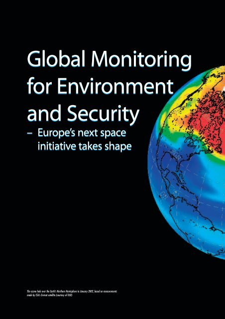
The ozone hole over the Earth’s Northern Hemisphere in January 2002, based on measurements<br />
made by <strong>ESA</strong>’s Envisat satellite (courtesy of DLR)
Volker Liebig<br />
<strong>ESA</strong> Directorate <strong>for</strong> Earth Observation<br />
Programmes, ESRIN, Frascati, Italy<br />
GMES<br />
Josef Aschbacher<br />
Programme Coordinator, Directorate <strong>for</strong> Earth<br />
Observation Programmes, <strong>ESA</strong>, Paris<br />
At the first Space Council in November<br />
2004, <strong>Global</strong> <strong>Monitoring</strong> <strong>for</strong> <strong>Environment</strong><br />
<strong>and</strong> <strong>Security</strong> (GMES) was proclaimed as<br />
the next flagship initiative <strong>for</strong> space in Europe,<br />
after Galileo. This underlines that GMES has<br />
come a long way since its beginnings in 1998.<br />
Initially conceived as a relatively loosely<br />
coordinated <strong>for</strong>um <strong>for</strong> cooperation among space<br />
agencies, GMES today st<strong>and</strong>s on firm ground.<br />
The European Commission has assumed political<br />
leadership <strong>for</strong> GMES, <strong>and</strong> the European Union’s<br />
policy priorities have been confirmed. A strong<br />
user base has been built up through numerous<br />
GMES projects funded since 2001 by <strong>ESA</strong> <strong>and</strong><br />
the Commission. Currently <strong>ESA</strong> is preparing,<br />
with its Member States, a firm proposal <strong>for</strong> the<br />
2005 Ministerial Council to start building up the<br />
space infrastructure necessary to sustain<br />
operational GMES services in the long term.<br />
Why GMES ?<br />
At their 2001 Summit in Gothenburg, the<br />
EU Heads of State <strong>and</strong> Government<br />
requested that: “the Community contribute<br />
to establishing by 2008 a European<br />
capacity <strong>for</strong> global monitoring <strong>for</strong><br />
environment <strong>and</strong> security (GMES)”.<br />
GMES serves two main policy<br />
requirements <strong>for</strong> Europe in terms of the<br />
need <strong>for</strong> geo-spatial in<strong>for</strong>mation services.<br />
Firstly, it provides independent access to<br />
in<strong>for</strong>mation <strong>for</strong> policy <strong>and</strong> decision makers<br />
to advance European <strong>and</strong> national agendas<br />
related to environment <strong>and</strong> security.<br />
Secondly, it federates European<br />
contributions to the international <strong>Global</strong><br />
Earth Observation System of Systems,<br />
esa bulletin 123 - august 2005 21
Earth Observation<br />
Map of global nitrogen-dioxide pollution, based on mesaurements made by Envisat between January 2003<br />
<strong>and</strong> June 2004. Inset: The pollution over Europe (courtesy University of Heidelberg, Germany)<br />
GEOSS, which was established at the<br />
Third Earth-Observation Summit in<br />
Brussels in February 2005.<br />
Europe’s Independent Access to <strong>Global</strong><br />
In<strong>for</strong>mation<br />
Access to in<strong>for</strong>mation has strategic value<br />
<strong>for</strong> the development of nations <strong>and</strong><br />
regions. GMES will contribute to Europe’s<br />
ability to fulfil its role as a global player.<br />
This entails the capacity to have<br />
independent access to reliable <strong>and</strong> timely<br />
in<strong>for</strong>mation on the status <strong>and</strong> evolution of<br />
the Earth’s environment at all scales, from<br />
global to regional <strong>and</strong> local. GMES must<br />
also ensure long-term, continuous<br />
monitoring based on space <strong>and</strong> in-situ<br />
observations on a time-scale of at least<br />
decades.<br />
Through GMES, Europe is now in the<br />
process of capitalising on its strengths by<br />
better coordinating its observation<br />
capacities, hence providing continuity of<br />
services to support the implementation of<br />
EU policies. These include policies in the<br />
domains of environment, agriculture,<br />
regional development, fisheries, transport,<br />
humanitarian aid <strong>and</strong> external relations, as<br />
well as the Common Foreign <strong>and</strong> <strong>Security</strong><br />
Policy <strong>and</strong> the European <strong>Security</strong> <strong>and</strong><br />
Defence Policy.<br />
The Third Earth Observation Summit in Brussels in February<br />
2005, at which the GEOSS 10-Year Implementation Plan was<br />
adopted<br />
GEOSS, the <strong>Global</strong> System of Systems<br />
The need <strong>for</strong> better-integrated observations<br />
has been recognised by different<br />
governments as a major pre-requisite to<br />
underst<strong>and</strong>ing global issues such as climate<br />
change <strong>and</strong> to tackling them appropriately<br />
at the political level. To advance the<br />
integration of these measurements, then US<br />
Secretary of State Colin Powell hosted the<br />
first Earth Observation Summit in<br />
Washington DC in July 2003. This was<br />
followed by intermediate <strong>and</strong> concluding<br />
Summits hosted by Japan’s Prime Minister<br />
Junichiro Koizumi in Tokyo in April 2004<br />
<strong>and</strong> EU Commissioners Verheugen <strong>and</strong><br />
Potocnik in Brussels in February 2005. A<br />
10-Year Implementation Plan <strong>for</strong> a <strong>Global</strong><br />
Earth Observation System of Systems,<br />
GEOSS, was adopted during the Brussels<br />
Summit, which asks <strong>for</strong> closer cooperation<br />
among the 60 governments <strong>and</strong> 40<br />
international organisations that constitute<br />
GEO today. Nine ‘Societal Benefit Areas’<br />
have been identified as the focus <strong>for</strong> the<br />
implementation of the 10-Year Plan: in<br />
short, disasters, health, energy, climate<br />
change, water, weather, coastal <strong>and</strong> marine<br />
ecosystems, desertification <strong>and</strong> biodiversity.<br />
The 10-Year Plan identifies 2-, 6<strong>and</strong><br />
10-year targets in terms of<br />
observational capabilities <strong>for</strong> the nine areas<br />
<strong>and</strong> indicates their benefits to society.<br />
Statements made by European governments<br />
<strong>and</strong> the European Commission have<br />
22 esa bulletin 123 - august 2005 www.esa.int
Variation in sea-surface temperature between March 2003 <strong>and</strong><br />
March 2004, based on measurements made by Envisat<br />
repeatedly underlined the intention to<br />
provide the European contribution to<br />
GEOSS via GMES. This will not include<br />
the totality of GMES, but rather those<br />
elements that are deemed appropriate to be<br />
shared at international level. Likewise,<br />
GMES will also act as recipient of data <strong>and</strong><br />
in<strong>for</strong>mation from external sources <strong>for</strong> the<br />
benefit of European users.<br />
Through GMES, Europe has established<br />
intellectual leadership in developing a<br />
holistic space <strong>and</strong> in-situ based<br />
observation system coupled with Earth<br />
system prediction models which is driven<br />
by policy needs identified by government<br />
authorities. Indeed, the GEOSS 10-Year<br />
Plan has taken advantage of GMES,<br />
translating some of Europe’s challenges to<br />
the global scale. In addition, a number of<br />
countries are establishing national<br />
systems, which serve their policy<br />
priorities. Examples are the USA, Japan,<br />
India, China or Morocco.<br />
IEOS – The US Equivalent of GMES<br />
The United States is developing the<br />
Integrated Earth Observation System,<br />
IEOS. A Strategic Plan <strong>for</strong> IEOS has been<br />
established over the past two years, which<br />
addresses the same nine societal benefit<br />
areas as GEOSS, hence allowing<br />
coherence between both systems from the<br />
outset. The Strategic Plan identifies six<br />
priority areas from the nine GEOSS<br />
domains that are to be tackled in the nearterm.<br />
These are: data management, disaster<br />
warning, global l<strong>and</strong> observations, sealevel<br />
observations, national drought<br />
in<strong>for</strong>mation, <strong>and</strong> air-quality <strong>for</strong>ecasts.<br />
The IEOS Strategic Plan was developed<br />
by 17 federal agencies that are part of the<br />
Interagency Working Group on Earth<br />
Observation, IWGEO. It reports to the<br />
National Science <strong>and</strong> Technology<br />
Council’s Committee on <strong>Environment</strong> <strong>and</strong><br />
Natural Resources, which advises the<br />
office of President George W. Bush on<br />
science <strong>and</strong> technology issues.<br />
The Content of GMES<br />
The overall GMES architecture comprises<br />
four major elements, as outlined in the EC<br />
Communication on GMES. These are<br />
services, space observations, in-situ<br />
observations, <strong>and</strong> data integration <strong>and</strong><br />
in<strong>for</strong>mation management. The establishment<br />
of a policy <strong>and</strong> regulatory<br />
framework, as well as the setting up of an<br />
institutional structure to govern, finance<br />
<strong>and</strong> operate GMES as a whole, are also<br />
required. They are dealt with in the GMES<br />
Programme Office at the working level,<br />
<strong>and</strong> by the GMES Advisory Committee at<br />
Member State level.<br />
From EU Policy Priorities to the GMES Space<br />
Component<br />
The definition of the GMES Space<br />
Component is based on a number of steps,<br />
such as: (i) the identification of EU policy<br />
priorities <strong>and</strong> the respective users within<br />
the EC <strong>and</strong> the EU/<strong>ESA</strong> Member States;<br />
(ii) the implementation of GMES service<br />
projects responding to these policy needs,<br />
such as those funded by the EC <strong>and</strong> <strong>ESA</strong><br />
over the past years; (iii) the retrieval of<br />
service requirements <strong>and</strong> spaceobservation<br />
requirements; <strong>and</strong> (iv) the<br />
identification of gaps in the continued<br />
provision of Earth Observation data <strong>for</strong><br />
European policies, after analysing the<br />
current <strong>and</strong> planned EO missions of <strong>ESA</strong>,<br />
EU/<strong>ESA</strong> Member States, Eumetsat <strong>and</strong><br />
third-party operators. The GMES<br />
‘Sentinel’ missions are defined as an<br />
output of these steps.<br />
Gathering requirements from these users<br />
has been a highly structured process<br />
conducted with their active participation.<br />
Within the framework of current GMES<br />
projects, the process has been based on<br />
policy review, traced down to the nature <strong>and</strong><br />
scope of responsibilities of legally<br />
m<strong>and</strong>ated organisations under the identified<br />
policies, followed by an assessment of their<br />
requirements <strong>for</strong> in<strong>for</strong>mation as well as the<br />
nature of their working practices <strong>and</strong><br />
applicable st<strong>and</strong>ards that place constraints<br />
to be met within such organisations.<br />
Data gaps are expected to occur in the<br />
near future. ERS-2 <strong>and</strong> Spot-4 have<br />
already exceeded their nominal lifetimes in<br />
2002, Envisat <strong>and</strong> Spot-5 have a nominal<br />
end-of-life in 2007, <strong>and</strong> the ETM imaging<br />
sensor on L<strong>and</strong>sat-7 has already failed a<br />
few years ago.<br />
Observation requirements <strong>for</strong> satellite<br />
instruments have been derived <strong>and</strong> the<br />
satellite elements aggregated into the<br />
definition of the space component of<br />
GMES, which is made up of components<br />
from <strong>ESA</strong>, Eumetsat <strong>and</strong> <strong>ESA</strong>/EU Member<br />
States.<br />
Who Are the GMES Users?<br />
GMES is user driven <strong>and</strong> responds directly<br />
to user requirements. In particular cases,<br />
requirements can come from users<br />
sufficiently expert in remote-sensing<br />
technologies. This is the case, <strong>for</strong> example,<br />
<strong>for</strong> the European <strong>Environment</strong> Agency<br />
requiring L<strong>and</strong>sat TM-class observations<br />
<strong>for</strong> operational updates to the Corine l<strong>and</strong>cover<br />
database, <strong>and</strong> <strong>for</strong> users involved in<br />
programmes such as <strong>Global</strong> L<strong>and</strong> Cover<br />
2000 (GLC2000) where there is a direct,<br />
demonstrated <strong>and</strong> endorsed requirement<br />
www.esa.int esa bulletin 123 - august 2005 23<br />
GMES
Earth Observation<br />
POLICIES→USERS→SERVICES→REQUIREMENTS→GAP ANALYSIS→SOLUTIONS<br />
<strong>for</strong> continuity of MERIS/vegetation-type<br />
measurements.<br />
In other cases, users have only recently<br />
been exposed to GMES services through<br />
dedicated GMES projects funded by <strong>ESA</strong>,<br />
the EC or Member States. The users<br />
comprise European, national <strong>and</strong> localgovernment<br />
level organisations, <strong>and</strong><br />
include environmental agencies, civil<br />
protection <strong>and</strong> safety agencies, city<br />
councils, coastguards, geological surveys,<br />
meteorological offices, fisherymanagement<br />
authorities, transport<br />
authorities, development <strong>and</strong> aid agencies,<br />
river-basin authorities, port authorities <strong>and</strong><br />
health departments.<br />
A recent survey identified some 330<br />
organisations as users of currently running<br />
GMES service projects. As these are<br />
organisations at European, national <strong>and</strong><br />
regional level, they have a multiplier effect<br />
in terms of the numbers of citizens<br />
benefiting from this in<strong>for</strong>mation. For<br />
example, the European <strong>Environment</strong><br />
Agency is using <strong>and</strong> redistributing<br />
satellite-based Corine l<strong>and</strong>-cover maps of<br />
the European territory at 1:50 000 scale to<br />
national environmental organisations <strong>for</strong><br />
further use <strong>and</strong> distribution.<br />
The 12 <strong>ESA</strong> GMES Service Element projects subscribed to at the<br />
<strong>ESA</strong> Ministerial Council in Edinburgh in 2001<br />
GMES Initial Services<br />
The GMES Advisory Council has<br />
endorsed a number of GMES Initial<br />
Services, which require immediate<br />
attention in terms of data provision <strong>and</strong><br />
service development. They have been<br />
derived from on-going GMES projects,<br />
<strong>and</strong> they satisfy EU policy priorities that<br />
are described in different documents. The<br />
identified GMES Initial Services cover:<br />
– Marine <strong>and</strong> coastal environment<br />
monitoring (including pollution, oil<br />
spills)<br />
– Risk management (floods <strong>and</strong> <strong>for</strong>est<br />
fires)<br />
– Risk management (subsidence <strong>and</strong><br />
l<strong>and</strong>slides)<br />
Analysis of the GMES space component based on EU policy<br />
priorities<br />
– Air-pollution monitoring (local to<br />
regional scales)<br />
– European water-quality monitoring<br />
– European l<strong>and</strong>-use / l<strong>and</strong>-cover state <strong>and</strong><br />
changes monitoring<br />
– Forest monitoring<br />
– Food security – early-warning systems<br />
– <strong>Global</strong>-change monitoring<br />
– Maritime security (marine transport,<br />
coastal-area surveillance, ice<br />
monitoring)<br />
– Humanitarian-aid support.<br />
All of these services are set to<br />
progressively enter the operational stage<br />
from 2010 onwards, provided that Earthobservation<br />
data are continuously available<br />
to users.<br />
GMES Pilot Services<br />
Among the Initial Services that the EC has<br />
identified are a limited number of early<br />
GMES pilot services to which it would<br />
give priority <strong>for</strong> operational implementation<br />
by 2008. These are:<br />
– Emergency management<br />
– L<strong>and</strong> monitoring<br />
– Ocean monitoring.<br />
It is planned to establish a fourth pilot<br />
service on atmospheric chemistry is in a<br />
second stage.<br />
The EC will engage in an intense userconsultation<br />
process through a series of<br />
three workshops at the end of 2005 in order<br />
24 esa bulletin 123 - august 2005 www.esa.int
to consolidate <strong>and</strong> update existing user<br />
requirements, develop an action plan <strong>for</strong><br />
2006-2008, <strong>and</strong> define criteria <strong>for</strong> the<br />
sustainability of the three GMES pilot<br />
services.<br />
The <strong>ESA</strong> GMES Space-Component Programme<br />
Proposal <strong>for</strong> the 2005 Ministerial Conference<br />
The <strong>ESA</strong> programme currently being<br />
negotiated with Member States in<br />
preparation <strong>for</strong> the 2005 Ministerial<br />
Council concentrates on the GMES space<br />
component, which comprises the space<br />
segment <strong>and</strong> the associated ground<br />
segment, including access to national,<br />
Eumetsat <strong>and</strong> third-party missions.<br />
In this context, it is worth recalling that<br />
<strong>ESA</strong>, several <strong>ESA</strong> Member States <strong>and</strong><br />
Eumetsat are funding a number of Earthobservation<br />
satellite programmes, which<br />
should become an integrated part of the<br />
overall architecture of the GMES space<br />
component. <strong>ESA</strong> has duly taken account of<br />
these missions <strong>and</strong> has designed the<br />
proposed satellite missions – the<br />
‘Sentinels’ – in a complementary manner.<br />
The following missions are c<strong>and</strong>idates<br />
<strong>for</strong> contributions to GMES:<br />
National<br />
– Spot-5 (operating)<br />
– TerraSAR-X (1 satellite, launch 2006)<br />
– Cosmo Skymed (3 satellites, launches<br />
2007, 2008, 2009)<br />
– Radarsat-2 (1 satellite, launch 2006); Cb<strong>and</strong><br />
constellation (tbc)<br />
– Pleiades (2 satellites, launches 2008,<br />
2009)<br />
– Other national missions (tbc).<br />
Eumetsat<br />
– Jason-2 (with CNES, 1 satellite, launch<br />
2006)<br />
– MSG (4 satellites, launches from 2002);<br />
MTG (launch 2015, tbc)<br />
– MetOp (3 satellites, launches from<br />
2006); Post-EPS (launch 2019, tbc).<br />
Privately funded or third-party missions<br />
– DMC-UK (constellation of satellites,<br />
launches from 2003)<br />
– RapidEye (5 satellites, launch 2007).<br />
The architecture of the GMES Space<br />
Component is designed in such a way that<br />
Flight models of MSG-2 <strong>and</strong> MSG-3 in the clean room at Alcatel Space in Cannes (F)<br />
a certain degree of dual-use capability can<br />
be achieved. This involves investments in<br />
the space segment, ground segment <strong>and</strong><br />
in<strong>for</strong>mation <strong>and</strong> service dissemination<br />
element. Details of security-related aspects<br />
will be defined during 2006-2007 <strong>and</strong><br />
proposed in a later phase (post-2008) of<br />
the GMES Space-Component Programme.<br />
GMES Sentinels<br />
The following five members of the<br />
Sentinel family have been identified as<br />
core elements of the GMES Space<br />
Component:<br />
Sentinel-1 a radar imaging mission<br />
with interferometric<br />
capability<br />
Sentinel-2 a multispectral optical<br />
imaging mission<br />
Sentinel-3 an ocean <strong>and</strong> global-l<strong>and</strong><br />
surface monitoring<br />
mission with altimeters<br />
<strong>and</strong> wide swath, low-to<br />
medium resolution radiometers<br />
Sentinel-4, -5 two families of atmospheric<br />
chemistry missions,<br />
on geostationary (Sentinel<br />
4) <strong>and</strong> low Earth orbit<br />
(Sentinel-5) spacecraft.<br />
GMES-1, the First GMES Mission<br />
The core element of the <strong>ESA</strong> programme<br />
proposal <strong>for</strong> the 2005 Ministerial<br />
Conference includes the development of a<br />
first GMES mission, GMES-1, planned <strong>for</strong><br />
launch in 2010/11. This mission’s<br />
definition is driven by three factors. Firstly,<br />
as mentioned above gaps in data will occur<br />
in the 2009-2011 time frame. Secondly, no<br />
definitive financial commitments are<br />
expected from the EC be<strong>for</strong>e 2007. And<br />
thirdly, the developments must be the basis<br />
<strong>for</strong> a robust <strong>and</strong> af<strong>for</strong>dable operational<br />
system, incorporating sufficient flexibility<br />
<strong>and</strong> modularity to allow <strong>for</strong> the anticipated<br />
evolution that will occur throughout the<br />
extended lifetime of the system.<br />
The GMES-1 mission will satisfy the<br />
most urgent data needs by combining<br />
selected instruments on one spacecraft, the<br />
design of which will allow <strong>for</strong> future<br />
payload growth. The envisaged instrument<br />
package <strong>for</strong>ms a coherent set of<br />
instruments, sharing similar constraints in<br />
terms of orbit requirements. It is<br />
anticipated that the instruments developed<br />
<strong>for</strong> GMES-1 will also be used on the future<br />
operational series of GMES satellites.<br />
Aimed at addressing the observational<br />
needs of Sentinel-1 <strong>and</strong> -3, as a starting<br />
point GMES-1 will include a C-b<strong>and</strong><br />
imaging radar capable of continuing the<br />
interferometric <strong>and</strong> ocean/ice/l<strong>and</strong><br />
measurements of ERS <strong>and</strong> Envisat, as well<br />
as an ocean-colour instrument providing<br />
continuity of MERIS-type measurements.<br />
An infrared instrument <strong>for</strong> fire monitoring<br />
www.esa.int esa bulletin 123 - august 2005 25<br />
GMES
Earth Observation<br />
will also be included to demonstrate its<br />
capabilities. The option of embarking an<br />
infrared radiometer (AATSR-type SST<br />
instrument) or a radar altimeter will also<br />
be investigated early in the programme.<br />
GMES Ground Segment<br />
The GMES ground segment related<br />
to space data comprises tasking, telecomm<strong>and</strong><br />
<strong>and</strong> tele-control, acquisition,<br />
archiving, processing up to appropriate<br />
product level <strong>and</strong> distribution of Earthobservation<br />
data according to GMES<br />
service needs. It includes the payload<br />
ground segment, flight-operations segment<br />
as well as access to historical data. The<br />
payload ground segment is based on<br />
existing national <strong>and</strong> commercial facilities<br />
in a fully distributed approach. In addition,<br />
access to <strong>and</strong> integration of Earthobservation<br />
data from Eumetsat, national<br />
<strong>and</strong> third-party missions are provided to<br />
users via the GMES ground segment.<br />
GMES Service Portfolio Extension<br />
GMES services must serve many diverse<br />
user communities in Europe <strong>and</strong><br />
worldwide, continuously integrate new<br />
techniques <strong>and</strong> research advances from<br />
many different fields, exploit spatial <strong>and</strong><br />
non-spatial data from a multitude of<br />
different sources including newly available<br />
satellite data, <strong>and</strong> evolve to deliver new<br />
<strong>for</strong>ecasting, prediction <strong>and</strong> early-warning<br />
capabilities. The service extension will<br />
contribute to bringing the current GMES<br />
services to full operational status <strong>and</strong> to<br />
developing new Earth-observation-based<br />
GMES services. It is understood that this<br />
element is to be funded through (future)<br />
European Commission budgets as part of<br />
the joint implementation of GMES by the<br />
Commission <strong>and</strong> <strong>ESA</strong>.<br />
GMES Operations<br />
The operation of the GMES space<br />
component covers the space, ground <strong>and</strong><br />
service segments. The different GMES<br />
missions (Sentinels, Eumetsat, national)<br />
<strong>and</strong> their related ground segments will be<br />
operated by different entities, with <strong>ESA</strong><br />
ensuring the integrity <strong>and</strong> coordination of<br />
the GMES space component.<br />
The operating entities <strong>for</strong> the GMES<br />
Sentinel family will emerge over the next<br />
years in parallel with an agreement on the<br />
governance of GMES as a whole.<br />
Cooperation with the European Commission<br />
GMES has, from the outset, been a<br />
cooperative ef<strong>for</strong>t involving all major<br />
stakeholders in Europe. Over the past<br />
years, the Commission <strong>and</strong> <strong>ESA</strong> have<br />
cooperated on GMES on behalf of their<br />
respective Member States. Investments so<br />
far have focused on the consolidation of<br />
the GMES user base <strong>and</strong> the provision of<br />
initial services. <strong>ESA</strong> <strong>and</strong> the Commission<br />
have each provided some 100 MEuro <strong>for</strong><br />
the development of services based on EC<br />
<strong>and</strong> EU/<strong>ESA</strong> Member State priorities. In<br />
2004, the <strong>ESA</strong> Member States have<br />
approved an additional 40 MEuro <strong>for</strong><br />
preparatory studies of the GMES space<br />
component.<br />
The GMES Advisory Council <strong>and</strong><br />
GMES Programme Office lead the GMES<br />
process. The GMES Advisory Council is<br />
chaired by the European Commission (DG<br />
<strong>Environment</strong>, to underline the user-driven<br />
aspect of GMES). The GMES Programme<br />
Office is co-led by the Commission <strong>and</strong><br />
<strong>ESA</strong>.<br />
The model of shared responsibility has<br />
been a successful means to continuously<br />
move GMES <strong>for</strong>ward. It has led to the<br />
consolidation of a significant user base<br />
across Europe <strong>and</strong> has raised the political<br />
awareness in the EC <strong>and</strong> the EU <strong>and</strong> <strong>ESA</strong><br />
Member States. On the international scale,<br />
GMES has been portrayed as a model <strong>for</strong><br />
establishing the <strong>Global</strong> Earth Observation<br />
System of Systems, GEOSS.<br />
Taking these considerations into<br />
account, <strong>and</strong> making use of existing coordination<br />
<strong>and</strong> consultation mechanisms,<br />
<strong>ESA</strong> continues to closely coordinate the<br />
definition of the GMES space component<br />
with the EC <strong>and</strong> the EU/<strong>ESA</strong> Member<br />
States using existing mechanisms, such as<br />
the GMES Advisory Council <strong>for</strong> the<br />
definition of the GMES Space-Component<br />
Programme.<br />
Implementation Approach<br />
The approach proposed has to be<br />
compatible with the fact that no definitive<br />
financial commitments will be available<br />
from user entities, represented through the<br />
European Commission, be<strong>for</strong>e 2007. The<br />
second programme imperative is to<br />
anticipate potential data gaps that might<br />
occur in the period 2008-2012, particularly<br />
in:<br />
– the C-b<strong>and</strong> radar imaging <strong>and</strong> interferometric<br />
capability<br />
– L<strong>and</strong>sat-Spot type data<br />
– wide-swath radiometer data.<br />
The implementation of the GMES Space-<br />
Component Programme is proposed to<br />
take place in two segments:<br />
– Segment-1 covering the period 2006<br />
2012, <strong>and</strong><br />
– Segment-2 covering the period 2008<br />
2013.<br />
Segment-1 will be funded through the <strong>ESA</strong><br />
Optional Programme, while Segment-2 is<br />
expected to be co-financed with the<br />
European Commission according to a<br />
financing model to be agreed in 2007.<br />
Outlook<br />
Data continuity over a period of decades is<br />
a key requirement <strong>for</strong> operational services.<br />
In order to prepare <strong>for</strong> the full<br />
implementation of GMES, the <strong>ESA</strong> Space-<br />
Component Programme assures data<br />
continuity <strong>for</strong> critical satellite observations<br />
from 2010/2011 onwards. The Ministerial<br />
Conference will be a decisive event, in<br />
particular <strong>for</strong> <strong>ESA</strong>, to ensure that GMES<br />
continues to move <strong>for</strong>ward.<br />
Only a well-funded <strong>and</strong> strongly<br />
implemented GMES can serve the<br />
ambitious goal of Europe becoming one of<br />
the most dynamic knowledge-based<br />
societies in the World. Furthermore,<br />
GMES has provided intellectual leadership<br />
in establishing the <strong>Global</strong> Earth<br />
Observation System of Systems, GEOSS.<br />
It is important that Europe continues to<br />
support this leadership through action,<br />
thus providing a favourable plat<strong>for</strong>m <strong>for</strong><br />
Europe’s industry, institutions, organisations<br />
<strong>and</strong> scientists to maintain a leading<br />
edge in preserving the global environment<br />
<strong>and</strong> ensuring security to Europe’s citizens<br />
<strong>and</strong> people everywhere. r<br />
26 esa bulletin 123 - august 2005 www.esa.int