R - City of Manteca
R - City of Manteca
R - City of Manteca

You also want an ePaper? Increase the reach of your titles
YUMPU automatically turns print PDFs into web optimized ePapers that Google loves.
DRAFT (As <strong>of</strong> 2/1//2013)<br />
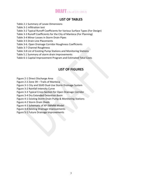
LIST OF TABLES<br />
Table 2.1 Summary <strong>of</strong> Levee Dimensions<br />
Table 3‐1 infiltration test<br />
Table 3‐2 Typical Run<strong>of</strong>f Coefficients for Various Surface Types (For Design)<br />
Table 3‐3 Run<strong>of</strong>f Coefficients for the <strong>City</strong> <strong>of</strong> <strong>Manteca</strong> (For Planning)<br />
Table 3‐4 Minor Losses in Storm Drain Pipes<br />
Table 3‐5 Drain Line Placements<br />
Table 3‐6. Open Drainage Corridor Roughness Coefficients<br />
Table 3‐7 Channel Roughness<br />
Table 3.8 List <strong>of</strong> Existing Pump Stations and Monitoring Stations<br />
Table 5.1 Summary <strong>of</strong> storm drain Improvements<br />
Table 6‐1 Capital Improvement Program and Estimated Total Costs<br />
LIST OF FIGURES<br />
Figure 2‐1 Direct Discharge Area<br />
Figure 2‐2 Zone 39 – Trails <strong>of</strong> <strong>Manteca</strong><br />
Figure 3‐1 <strong>City</strong> and SSJID Dual‐Use Storm Drainage System<br />
Figure 3‐2 Rainfall Intensity Curve<br />
Figure 3‐3 Typical Cross‐Section for Open Drainage Corridor<br />
Figure 3‐4 Dry Extended Detention Basin<br />
Figure 4‐1 Existing Storm Drain Pump & Monitoring Stations<br />
Figure 4‐2 Storm Drain Sheds<br />
Figure 4‐3 Schematic <strong>of</strong> XP‐SWMM Model<br />
Figure 4‐4 Existing Drainage Improvements<br />
Figure 5‐1 Future Drainage Improvements<br />
3