PUBLIC HEARING REPORT - City of Houston
PUBLIC HEARING REPORT - City of Houston
PUBLIC HEARING REPORT - City of Houston

Create successful ePaper yourself
Turn your PDF publications into a flip-book with our unique Google optimized e-Paper software.
2013 Major Thoroughfare and Freeway Plan CITY OF HOUSTON<br />
Amendment Request PLANNING AND DEVELOPMENT DEPARTMENT<br />
<strong>PUBLIC</strong> <strong>HEARING</strong> <strong>REPORT</strong><br />
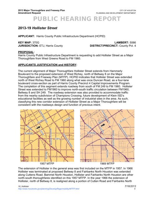
2013-19 Hollister Street<br />
APPLICANT: Harris County Public Infrastructure Department (HCPID)<br />
KEY MAP: 370G LAMBERT: 5066<br />
JURISDICTION: ETJ, Harris County DISTRICT/PRECINCT: County Pct. 4<br />
PROPOSAL:<br />
Harris County Public Infrastructure Department is requesting to add Hollister Street as a Major<br />
Thoroughfare from West Greens Road to FM 1960.<br />
APPLICANTS JUSTIFICATION and HISTORY:<br />
The current alignment <strong>of</strong> Major Thoroughfare Hollister Street extends from Hammerly<br />
Boulevard to the proposed extension <strong>of</strong> West Richey, north <strong>of</strong> Beltway 8 on the Major<br />
Thoroughfare and Freeway Plan (MTFP). HCPID indicates that Hollister Street was extended<br />
north <strong>of</strong> West Richey Road to FM 1960 along what was once Duncan Road, as a four-lane<br />
boulevard cross-section as part <strong>of</strong> Harris County Precinct 4 Capital Improvements Program.<br />
The completion <strong>of</strong> this segment extends roadway from south <strong>of</strong> FM 249 to FM 1960. Hollister<br />
Street was extended to FM1960 to improve north-south traffic circulation between FM1960,<br />
Beltway 8 and SH 249. The roadway extension was also provided to accommodate traffic<br />
from the nearby subdivision <strong>of</strong> Champions Crossing, future development <strong>of</strong> Klein ISD’s<br />
educational facilities as well as the growing number <strong>of</strong> industrial sites in the area. As such,<br />
classifying this new corridor extension <strong>of</strong> Hollister Street as a Major Thoroughfare will be<br />
consistent with the roadways design and function <strong>of</strong> previous intent.<br />
1957 MTFP 1969 MTFP<br />
The extension <strong>of</strong> Hollister in the general area was first included on the MTFP in 1957. In 1966<br />
Hollister was terminated at proposed Beltway 8 and Fairbanks North <strong>Houston</strong> was extended<br />
along Cuttens Road. Bammel North <strong>Houston</strong>, Hollister and Fairbanks North <strong>Houston</strong> are other<br />
north-south thoroughfares identified on this 1957 MTFP. In the year 1966 the extension <strong>of</strong><br />
Hollister, north <strong>of</strong> Beltway 8, is realigned along a portion <strong>of</strong> Cutten Road and Fairbanks North<br />
19_Hollister 7/16/2013<br />
http://www.houstontx.gov/planning/DevelopRegs/mobility/MTFP.html<br />
1
2013 Major Thoroughfare and Freeway Plan CITY OF HOUSTON<br />
Amendment Request PLANNING AND DEVELOPMENT DEPARTMENT<br />
<strong>PUBLIC</strong> <strong>HEARING</strong> <strong>REPORT</strong><br />
<strong>Houston</strong>. Greens Road is realigned to be tied into an existing east-west unnamed thoroughfare<br />
(Cypress N. <strong>Houston</strong>). In 1969 Fairbanks North <strong>Houston</strong> is realigned along an unnamed eastwest<br />
thoroughfare (Richey Road) south <strong>of</strong> FM 1960. Major thoroughfare Cutten Road is<br />
terminated at West Greens Road and is realigned from Greens Bayou to the Beltway 8 and<br />
Hollister Street. Between 1966 and 1980 there were a number <strong>of</strong> realignments to thoroughfares<br />
in the general area. The 1980 MTFP map identifies portion <strong>of</strong> Greens Road between Hollister<br />
and Stuebner Airline is realigned south <strong>of</strong> Greens Bayou. West Richey Road is realigned and<br />
terminates at Cutten Road. The map indicates Hollister Street realigned to terminate at West<br />
Richey Road. Fairbanks North <strong>Houston</strong> terminates at Beltway 8. Champion Forest is<br />
terminated at Bammel North <strong>Houston</strong> and Bammel North <strong>Houston</strong> is extended to FM 1960.<br />
In 2000 Greens Road, east <strong>of</strong> SH 249 to Cutten Road, was realigned along West Richey Road.<br />
In 2010 Greens Road was realigned from Cutten Road to the east side <strong>of</strong> its intersection with<br />
Bammel North <strong>Houston</strong> to allow for the direct extension <strong>of</strong> Cutten Road into West Greens Road<br />
away from Greens Bayou.<br />
1980 MTFP 2000 MTFP<br />
2010 MTFP 2012 MTFP<br />
19_Hollister 7/16/2013<br />
http://www.houstontx.gov/planning/DevelopRegs/mobility/MTFP.html<br />
2
2013 Major Thoroughfare and Freeway Plan CITY OF HOUSTON<br />
Amendment Request PLANNING AND DEVELOPMENT DEPARTMENT<br />
<strong>PUBLIC</strong> <strong>HEARING</strong> <strong>REPORT</strong><br />
Population & Employment Projections:<br />
According to 2010 Census, Texas grew by 20% in ten years, to over 25 million people,<br />
recording about a quarter <strong>of</strong> the nation’s overall growth. The rate <strong>of</strong> growth in Texas was twice<br />
the national average. Harris County is the most populous county (4 million) in Texas. Today, 2.1<br />
million people live within the <strong>City</strong> <strong>of</strong> <strong>Houston</strong> and another 2 million live in the <strong>City</strong>’s<br />
extraterritorial jurisdiction (ETJ). Since 2000, the <strong>City</strong> <strong>of</strong> <strong>Houston</strong> added 146,000 people (8 %) to<br />
its population. <strong>Houston</strong>’s ETJ however grew 35 % during the same time period.<br />
<strong>Houston</strong> and its ETJ’s rich employment sector are home to more than 1.8 million jobs, making it<br />
the state’s most populous and robust economic center. More than one million jobs are located<br />
within the <strong>City</strong> limits and are saturated within the <strong>City</strong>’s eight major activity centers.<br />
One <strong>of</strong> the greatest challenges to <strong>Houston</strong>’s mobility is that by 2035 significant numbers <strong>of</strong><br />
residents are projected to live outside the <strong>City</strong> limits in the ETJ; while the major employment<br />
growth is expected to occur within the <strong>City</strong> limits. This increase in distance between the<br />
population and employment centers will result in more travel, greater travel time, and longer<br />
travel delays.<br />
In addition to anticipated growth within the ETJ, an additional 550,000 new residents are<br />
expected within the current city limits. The most notable population growth is projected to occur<br />
inside Loop 610. It reflects efforts to create a dense urban core through mixed-use<br />
development strategies.<br />
To compare the result between 2000 and 2010 Census, the subject area’s population grew by<br />
11% from 14,645 to 16,280 which demonstrates a percent change less than that <strong>of</strong> Harris<br />
County’s growth (20%).<br />
Year<br />
Population<br />
(Persons/Acre)<br />
2010 5.4<br />
%<br />
Change<br />
Households<br />
(Households/Acre)<br />
%<br />
Change<br />
Jobs<br />
(Jobs/Acre)<br />
%<br />
Change<br />
2015 5.9 9.7% 2.3 7.1% 5.0 5.9%<br />
2020 6.3 6.3% 2.5 7.0% 5.3 5.0%<br />
2025 6.6 4.7% 2.6 5.8% 5.6 4.8%<br />
2030 6.8 2.8% 2.7 3.6% 5.6 0.9%<br />
2035 6.8 0.4% 2.7 0.9% 5.6 0.3%<br />
Change (2010 to 2035) 1.4 26.2% 0.6 26.6% 0.9 17.9%<br />
<strong>City</strong> <strong>of</strong> <strong>Houston</strong> Change<br />
(2010 to 2035)<br />
1.6 30.4% 0.6 32.4% 1.3 32.9%<br />
<strong>City</strong> <strong>of</strong> <strong>Houston</strong> ETJ<br />
Change (2010 to 2035)<br />
1.3 53.4% 0.6 73.7% 0.6 85.6%<br />
Source: H-GAC’s 2035 Regional Growth Forecast<br />
* Data represents population, jobs, and households in 2 Traffic Analysis Zones (TAZ) encompassing approximately 3,545 acres<br />
around the proposed amendment. Population projections do not include projections for group housing.<br />
The <strong>Houston</strong>-Galveston Area Council (H-GAC) projects that over the next 25 years (2010 –<br />
2035), the population within the study area* will increase from 16,814 to 29,119 (12,305<br />
persons), or 73%. The number <strong>of</strong> persons per acre is projected to increase from approximately<br />
19_Hollister 7/16/2013<br />
http://www.houstontx.gov/planning/DevelopRegs/mobility/MTFP.html<br />
3<br />
2.1<br />
4.8
2013 Major Thoroughfare and Freeway Plan CITY OF HOUSTON<br />
Amendment Request PLANNING AND DEVELOPMENT DEPARTMENT<br />
<strong>PUBLIC</strong> <strong>HEARING</strong> <strong>REPORT</strong><br />
5.4 to approximately 6.8. During the same period, H-GAC estimates that the total jobs in the<br />
subject area will increase from 7,439 to 10,922 (3,483 jobs), or 47%. The number <strong>of</strong> jobs per<br />
acre is projected to increase from approximately 2.1 to 3.1.<br />
Expressed in percentages, the subject area’s population growth is expected to be more than the<br />
<strong>Houston</strong> ETJ’s (73% vs. 53%), and the area’s job growth is less than the <strong>Houston</strong> ETJ’s (47%<br />
vs. 85%).<br />
Land Use and Platting Activity:<br />
Platting activity in the area surrounding the requested MTFP amendment has been commercial<br />
in nature. The Cutten Road Business and Industrial Park located west <strong>of</strong> the proposed<br />
amendment request encompasses 133 acres along the west side <strong>of</strong> Cutten Road, north <strong>of</strong><br />
Greens Bayou. The existing land use along FM 1960 and Cutten Road is predominantly<br />
commercial and industrial uses whereas Hollister and Champion Forest has large single-family<br />
residential uses along the roadway. The existing land use along the proposed extension <strong>of</strong><br />
Hollister is primarily industrial.<br />
Subdivision Plat Name Action Date Key Map Land Use<br />
Property<br />
Size (ac)<br />
Cutten Road Business & Industrial Park 19-Mar-09 370K Commercial 133.08<br />
Cutten Road Business & Industrial Park<br />
replat no. 1 & extension<br />
29-Nov-12 370K Commercial 85.49<br />
Right-Of-Way (ROW) Status:<br />
No. <strong>of</strong><br />
Lots<br />
All corridors, with the exception <strong>of</strong> local roads, are classified as 4-lane thoroughfares with 100’<br />
ROW. The segment <strong>of</strong> Hollister Drive/Duncan amendment is proposed as a Major<br />
Thoroughfare similar to those described in the table below. All surrounding corridors are<br />
classified as maintaining “sufficient width.”<br />
Street From To Classification Status Direction<br />
Hollister/Duncan FM 1960 W. Richey/Weeds Local 100’ NW-SE<br />
Hollister/Duncan W. Richey/Weeds Bourgeois Major Thoroughfare Sufficient width NW-SE<br />
Cutten FM 1960 Bourgeois Major Thoroughfare Sufficient width NW-SE<br />
Champion Forest FM 1960 Bourgeois Major Thoroughfare Sufficient width NW-SE<br />
FM 1960 Cutten Campion Forest Major Thoroughfare Sufficient width NE-SW<br />
Richey/Weeds Cutten Hollister/Duncan Major Thoroughfare Proposed NE-SW<br />
Richey/Weeds Hollister/Duncan Bourgeois Major Thoroughfare Proposed NE-SW<br />
W. Richey Bourgeois Champion Forest Major Thoroughfare Sufficient width NE-SW<br />
Bourgeois Cutten Campion Forest Local 60’ NE-SW<br />
Spacing:<br />
Hollister Drive/Duncan provides northwest-southeast access through the study area located<br />
mid-way between Champion Forest Drive and Cutten Road. Hollister Drive/Duncan currently<br />
19_Hollister 7/16/2013<br />
http://www.houstontx.gov/planning/DevelopRegs/mobility/MTFP.html<br />
4
2013 Major Thoroughfare and Freeway Plan CITY OF HOUSTON<br />
Amendment Request PLANNING AND DEVELOPMENT DEPARTMENT<br />
<strong>PUBLIC</strong> <strong>HEARING</strong> <strong>REPORT</strong><br />
terminate at the proposed alignment for Weeds Road which is spaced approximately 0.78 mile<br />
from Cutten Road. The proposed amendment <strong>of</strong> Hollister Drive/Duncan would extend the<br />
current roadway by approximately one mile to FM 1960.<br />
Street From To Classification Direction Spacing<br />
Hollister/Duncan FM 1960 W. Richey/Weeds Local NW-SE 1.00 mile<br />
Hollister/Duncan W. Richey/Weeds Bourgeois Major Thoroughfare NW-SE 0.50 mile<br />
Cutten FM 1960 Greens/Weeds Major Thoroughfare NW-SE 1.00 mile<br />
Cutten Greens/Weeds Bourgeois Major Thoroughfare NW-SE 0.50 mile<br />
Champion Forest FM 1960 Bourgeois Major Thoroughfare NW-SE 1.50 mile<br />
FM 1960 Cutten Hollister/Duncan Major Thoroughfare NE-SW 0.70 mile<br />
FM 1960 Hollister/Duncan Campion Forest Major Thoroughfare NE-SW 0.80 mile<br />
W. Richey/Weeds Cutten Hollister/Duncan Major Thoroughfare NE-SW 0.78 mile<br />
W. Richey/Weeds Hollister/Duncan Bourgeois Major Thoroughfare NE-SW 0.50 mile<br />
W. Richey Bourgeois Champion Forest Major Thoroughfare NE-SW 0.50 mile<br />
Bourgeois Cutten Hollister/Duncan Local NE-SW 0.80 mile<br />
Bourgeois Hollister/Duncan Campion Forest Local NE-SW 0.50 mile<br />
19_Hollister 7/16/2013<br />
http://www.houstontx.gov/planning/DevelopRegs/mobility/MTFP.html<br />
5
CUTTEN<br />
SCHROEDER SOLON<br />
MILLS<br />
GESSNER<br />
GREENS<br />
0 0.5<br />
Miles<br />
1<br />
[<br />
SH 249<br />
CUTTEN<br />
FM 1960<br />
!( !( !( !( !( !( !( !( !( !(<br />
HOLLISTER/DUNCAN<br />
HOLLISTER/DUNCAN<br />
WEEDS<br />
GREENS<br />
CHAMPION FOREST<br />
HOLLISTER<br />
HOLLISTER / DUNCAN 2013 MTFPA REQUESTS<br />
BW 8<br />
VETERANS MEMORIAL<br />
BAMMEL N HOUSTON<br />
RICHEY<br />
LEGEND<br />
2013 MTFPA Request<br />
! !<br />
2012 MTFP<br />
Proposed Freeway<br />
ANTOINE<br />
Realign Major Thoroughfare<br />
TBW Freeway<br />
Freeway<br />
Major Thoroughfare<br />
TBW Major Thoroughfare<br />
Proposed Major Thoroughfare<br />
Major Collector<br />
TBW Major Collector<br />
Proposed Major Collector<br />
Transit Corridor Street<br />
Proposed Grand Parkway<br />
Railroad<br />
<strong>Houston</strong> <strong>City</strong> Limits<br />
Limited Purpose Annexation<br />
<strong>Houston</strong> ETJ