Hergie® track Measurement system
Hergie® track Measurement system
Hergie® track Measurement system

You also want an ePaper? Increase the reach of your titles
YUMPU automatically turns print PDFs into web optimized ePapers that Google loves.
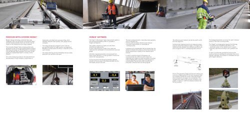
pREcisiOn witH a systEM: HERGiE ®<br />
Modern railway technology constantly faces new<br />
challenges: trains are becoming more powerful, faster<br />
and the intervals between them, ever shorter. The demands<br />
on the infrastructure are rising in parallel.<br />
The innovative Hergie ® <strong>track</strong> surveying <strong>system</strong> was<br />
developed as part of the high-speed Cologne-Frankfurt<br />
(Germany) rail project by Rhomberg Rail in cooperation<br />
with the Bahnbau Wels subsidiary. Since then its high<br />
quality has substantiated itself in a variety of other<br />
projects.<br />
This online measuring <strong>system</strong> for the adjustment and<br />
documentation of <strong>track</strong> condition, compromises of<br />
tachymeter-controlled <strong>track</strong> surveying trolley, which<br />
optimally measures <strong>track</strong> position, cant, gauge and rail<br />
inclination.<br />
The measured data are compared “online” with the<br />
pre-specified values for height, position and alignment.<br />
Deviations to these values are shown in real-time on the<br />
user’s monitor.<br />
This means that they can be immediately and accurately<br />
detected to be rectified on the spot.<br />
HERGiE ® sOftwaRE<br />
The “heart” of the Hergie ® <strong>track</strong> measurement <strong>system</strong> is<br />
the software developed by RTE. It is available in<br />
English and Spanish.<br />
The <strong>system</strong> is based on a highly accurate, three-<br />
dimensional single position.<br />
At each measuring point, a total of five values are<br />
measured: the coordinates in three dimensions, cant and<br />
gauge.<br />
All further required parameters can be derived from<br />
these values. Moreover, it is also possible to monitor the<br />
entire inner <strong>track</strong> geometry.<br />
As the precision of the derived parameters depends<br />
directly on the accuracy of the measured data, only the<br />
best quality sensors are used.<br />
The basic prerequirements in describing <strong>track</strong> geometry<br />
using coordinates are:<br />
• An accurate and stable reference-point network<br />
• Accurate measurements of coordinates at<br />
individual points<br />
Longwave errors (wavelengths that are greater than the<br />
distances between the positions of the instruments) are<br />
directly proportional to quality of the reference-point<br />
network.<br />
In order to avoid the impact of longwaves, we<br />
recommend that the reference-point network be<br />
measured with a highly accurate, tachymeter-controlled<br />
method. Mobile pillars containing a centring device is<br />
recommended. They are also used to position the<br />
tachymeter while the <strong>track</strong>s are being aligned.<br />
The reference-point network can also be used to verify<br />
the <strong>track</strong> alignment.<br />
Individual <strong>track</strong> alignment points are measured using a<br />
precision tachymeter (direction angle ≥ 0.3 mgon). The<br />
relative accuracy between two reference points at a distance<br />
of approx. 60 m is subsequently below 0.5 mm.<br />
Picture: The geometric height and direction relations are<br />
shown at a single position of the <strong>track</strong> surveying trolley.<br />
An inclination towards the centre of the <strong>track</strong> (longitudinal<br />
inclination) is not taken into consideration. For a<br />
standard <strong>track</strong> width (1.435 mm) the inclination in the<br />
graphic is based on 1.500 mm (distance between the<br />
two rail centres).<br />
The displayed parameters are shown for each individual<br />
position of the <strong>track</strong> surveying trolley.<br />
The Hergie ® surveying <strong>system</strong> requires the following:<br />
• a positioned and orientated total station in the<br />
coordinate <strong>system</strong> of the reference-point network<br />
• Geometry specified according to axis, gradients and<br />
cant<br />
In order to continuously provide the most accurate<br />
results, all sensors, including the tachymeter have to be<br />
regularly calibrated. The software is compatible and supports<br />
regular calibration.