Download information about Geiranger-Trollstigen - Fjord Norway
Download information about Geiranger-Trollstigen - Fjord Norway
Download information about Geiranger-Trollstigen - Fjord Norway

You also want an ePaper? Increase the reach of your titles
YUMPU automatically turns print PDFs into web optimized ePapers that Google loves.
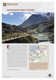
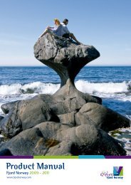
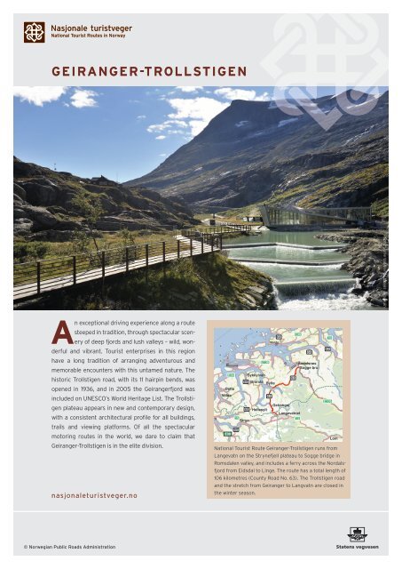
GEIRANGER-TROLLSTIGEN<br />
An exceptional driving experience along a route<br />
steeped in tradition, through spectacular scen-<br />
ery of deep fjords and lush valleys – wild, won-<br />
derful and vibrant. Tourist enterprises in this region<br />
have a long tradition of arranging adventurous and<br />
memorable encounters with this untamed nature. The<br />
historic <strong>Trollstigen</strong> road, with its 11 hairpin bends, was<br />
opened in 1936, and in 2005 the <strong>Geiranger</strong>fjord was<br />
included on UNESCO’s World Heritage List. The Trollsti-<br />
gen plateau appears in new and contemporary design,<br />
with a consistent architectural profile for all buildings,<br />
trails and viewing platforms. Of all the spectacular<br />
motoring routes in the world, we dare to claim that<br />
<strong>Geiranger</strong>-<strong>Trollstigen</strong> is in the elite division.<br />
nasjonaleturistveger.no<br />
© Norwegian Public Roads Administration<br />
Ålesund<br />
E39<br />
E39<br />
Ørsta<br />
Volda<br />
15<br />
Stryn<br />
60<br />
60<br />
E136<br />
Sykkylven<br />
60 Stranda Sylte<br />
Hellesylt<br />
63<br />
Molde<br />
64<br />
<strong>Geiranger</strong><br />
63<br />
E39<br />
Langevatnet<br />
15<br />
64<br />
Åndalsnes<br />
Sogge bru<br />
62<br />
70<br />
E136<br />
Lom<br />
National Tourist Route <strong>Geiranger</strong>-<strong>Trollstigen</strong> runs from<br />
Langevatn on the Strynefjell plateau to Sogge bridge in<br />
Romsdalen valley, and includes a ferry across the Nordalsfjord<br />
from Eidsdal to Linge. The route has a total length of<br />
106 kilometres (County Road No. 63). The <strong>Trollstigen</strong> road<br />
and the stretch from <strong>Geiranger</strong> to Langvatn are closed in<br />
the winter season.<br />
Photo: Jarle Wæhler / Statens vegvesen
18 NATIONAL TOURIST ROUTES. Each of these<br />
selected routes represents a unique motoring<br />
experience, and each offers its own special<br />
combination of road, scenery and history.<br />
Our job is to ensure that you have an<br />
enjoyable journey. We do this by<br />
constructing spectacular viewing<br />
platforms and by providing<br />
service facilities, car parks,<br />
picnic areas, walking trails<br />
and artworks.<br />
1 LINGE FERRY QUAY. Linge is the port for the ferry<br />
connection to Eidsdal on County Road No. 63. Service facilities<br />
and a waiting room are available. Architect: Knut Hjeltnes AS.<br />
2 ØRNESVINGEN. This viewing platform is located at the<br />
uppermost hairpin bend of the Ørnevegen road, and offers a<br />
breathtaking view. From here, you can see towards <strong>Geiranger</strong>, over<br />
the <strong>Geiranger</strong>fjord with its precipitous hillsides, the cascading<br />
waterfall The Seven Sisters and the mountain hamlet of Knivsflå.<br />
Architect: 3 RW arkitekter - Sixten Rahlff. Artist: May Eikås Bjerk.<br />
Landscape architect: Smedsvig landskapsarkitekter AS.<br />
3 FLYDALSJUVET GORGE. Viewing platform and rest<br />
area with service facilities. The Flydalsjuvet viewing platform is<br />
designed with an upper and a lower level connected by a walkway.<br />
Here, you can enjoy the majestic view over <strong>Geiranger</strong> or capture<br />
the scene in a cracking photo. Architect: 3 RW arkitekter – Sixten<br />
Rahlff. Landscape architect: Smedsvig landskapsarkitekter AS.<br />
4 GUDBRANDSJUVET GORGE. A circular-shaped viewing<br />
platform leads through the terrain up to the Gudbrandsjuvet<br />
Café, located at the very edge of the swirling Valldøla river. The<br />
café and viewing platform make an appealing contrast to the high-<br />
altitude scenery, and provide a vivid and close-up impression of the<br />
gorge and the river. Architect: Jensen & Skodvin Arkitektkontor AS.<br />
5 TROLLSTIGEN. On the <strong>Trollstigen</strong> plateau you can<br />
experience this overwhelming and majestic landscape at close<br />
range. The architectural design is adapted to the landscape, with<br />
materials that can withstand the force of the elements. The view-<br />
ing platforms hover above the <strong>Trollstigen</strong> road, which meanders<br />
along precipitous mountainsides and curves upwards on the<br />
near-vertical slopes. Architect: Reiulf Ramstad Arkitekter AS.<br />
Landscape architect: Multiconsult.<br />
Photos: Statens vegvesen<br />
Statens vegvesen<br />
Turistvegseksjonen<br />
Address:<br />
Industrigata 17<br />
N-2605 Lillehammer<br />
Gamle Strynefjellsvegen<br />
Gaularfjellet<br />
Hardanger<br />
Jæren<br />
Atlanterhavsvegen<br />
Rondane<br />
Sognefjellet<br />
Valdresflye<br />
Aurlandsfjellet<br />
Ryfylke<br />
<strong>Geiranger</strong>-<strong>Trollstigen</strong><br />
Hardangervidda<br />
Postal address:<br />
PO Box 1010<br />
N-2605 Lillehammer<br />
Lofoten<br />
Senja<br />
Andøya<br />
Helgelandskysten<br />
Phone:<br />
+47 815 22 000<br />
Havøysund<br />
1<br />
2<br />
3<br />
4<br />
5<br />
Varanger<br />
E-mail:<br />
turistvegkontoret@vegvesen.no<br />
Internet:<br />
nasjonaleturistveger.no<br />
vegvesen.no/nasjonaleturistveger<br />
0541-12 grafisk.senter@vegvesen.no