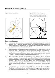
maori commercial aquaculture settlement - Ministry of Fisheries
maori commercial aquaculture settlement - Ministry of Fisheries
maori commercial aquaculture settlement - Ministry of Fisheries

You also want an ePaper? Increase the reach of your titles
YUMPU automatically turns print PDFs into web optimized ePapers that Google loves.
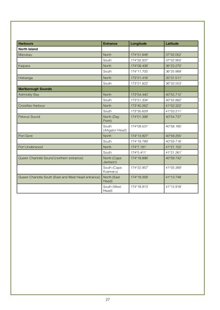
Harbours Entrance Longitude Latitude<br />
North Island<br />
Manukau North 174°31.848’ 37°02.052’<br />
South 174°32.507’ 37°02.950’<br />
Kaipara North 174°09.438’ 36°23.270’<br />
South 174°11.705’ 36°25.989’<br />
Hokianga North 173°21.416’ 35°31.511’<br />
Marlborough Sounds<br />
South 173°21.822’ 36°32.553’<br />
Admiralty Bay North 173°54.440’ 40°55.712’<br />
South 173°51.334’ 40°55.882’<br />
Croisilles Harbour North 173°40.262’ 41°02.322’<br />
South 173°35.629’ 41°03.211’<br />
Pelorus Sound North (Day<br />
Point)<br />
174°01.398’ 40°54.737’<br />
South<br />
(Alligator Head)<br />
174°09.531’ 40°58.180’<br />
Port Gore North 174°13.927’ 40°59.255’<br />
South 174°18.789’ 40°59.716’<br />
Port Underwood North 174°7.181’ 41°21.152’<br />
South 174°5.411’ 41°21.261’<br />
Queen Charlotte Sound (northern entrance) North (Cape<br />
Jackson)<br />
174°18.896’ 40°59.742’<br />
South (Cape<br />
Koamaru)<br />
174°22.957’ 41°05.389’<br />
Queen Charlotte South (East and West Head entrance) North (East<br />
Head)<br />
174°19.358’ 41°12.748’<br />
South (West<br />
Head)<br />
174°18.913’ 41°12.918’<br />
27