gdems - General Dynamics Itronix
gdems - General Dynamics Itronix
gdems - General Dynamics Itronix

You also want an ePaper? Increase the reach of your titles
YUMPU automatically turns print PDFs into web optimized ePapers that Google loves.
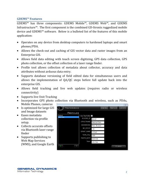
GDEMS Features<br />
GDEMS has three components: GDEMS Mobile, GDEMS Web, and GDEMS<br />
Infrastructure. The first component is the combined GD-<strong>Itronix</strong> ruggedized mobile<br />
device and GDEMS software. Below is a bulleted list of the features of this mobile<br />
application:<br />
Operates on any device from desktop computers to hardened laptops and smart<br />
phones/PDA.<br />
Allows the check-out and caching of GIS vector data and raster images from an<br />
Enterprise GIS.<br />
Allows field data editing with touch screen digitizing, GPS data collection, GPS<br />
photo collection, or the offset collection of a laser range finder.<br />
Profile tool allows collection of metadata about collector, accuracy and data<br />
attributes without arduous data entry.<br />
Supports database versioning of field edited data for simultaneous users and<br />
allows the implementation of QA/QC steps before full update back into the<br />
enterprise GIS.<br />
Allows field tracking and live web updates (requires radio or wireless<br />
connectivity)<br />
Supports live Unit Tracking<br />
Incorporates GPS photo collection via Bluetooth and wireless, such as PDAs,<br />
Mobile Phones, cameras<br />
Is optimized for large GIS<br />
and Image datasets<br />
Eases metadata<br />
collection via profile<br />
setup.<br />
Collects accurate offsets<br />
via Bluetooth laser range<br />
finder<br />
Supports publishing to<br />
Web Map Services<br />
(WMS), and Google Earth<br />
2