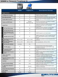
gdems - General Dynamics Itronix
gdems - General Dynamics Itronix
gdems - General Dynamics Itronix

You also want an ePaper? Increase the reach of your titles
YUMPU automatically turns print PDFs into web optimized ePapers that Google loves.
GENERAL DYNAMICS ENTERPRISE MAPPING SOLUTION (GDEMS)<br />
Introduction<br />
G<br />
eneral <strong>Dynamics</strong> Information Technology (GDIT) presents GDEMS, a<br />
Geographic Information System (GIS) hardware and software solution that<br />
simplifies data collection using best of breed hardware components, cuttingedge<br />
collection tools, and standardized Service Oriented Architecture (SOA) data<br />
support. GDEMS operates within an ESRI Enterprise GIS and <strong>General</strong> <strong>Dynamics</strong><br />
provides co-location and hosting to ensure that you have an integrated solution that<br />
does not require expensive software licensing, server hardware, or IT personnel.<br />
Background<br />
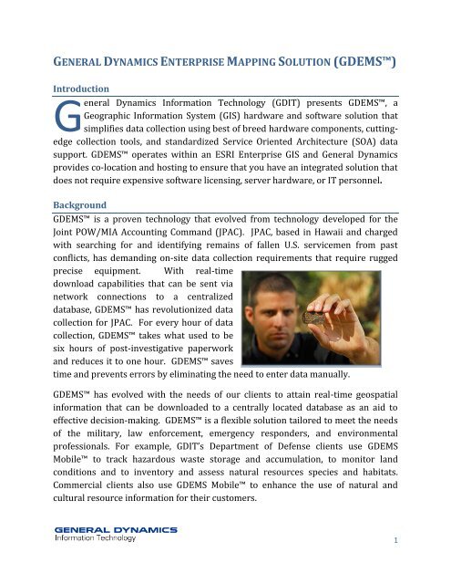
GDEMS is a proven technology that evolved from technology developed for the<br />
Joint POW/MIA Accounting Command (JPAC). JPAC, based in Hawaii and charged<br />
with searching for and identifying remains of fallen U.S. servicemen from past<br />
conflicts, has demanding on-site data collection requirements that require rugged<br />
precise equipment. With real-time<br />
download capabilities that can be sent via<br />
network connections to a centralized<br />
database, GDEMS has revolutionized data<br />
collection for JPAC. For every hour of data<br />
collection, GDEMS takes what used to be<br />
six hours of post-investigative paperwork<br />
and reduces it to one hour. GDEMS saves<br />
time and prevents errors by eliminating the need to enter data manually.<br />
GDEMS has evolved with the needs of our clients to attain real-time geospatial<br />
information that can be downloaded to a centrally located database as an aid to<br />
effective decision-making. GDEMS is a flexible solution tailored to meet the needs<br />
of the military, law enforcement, emergency responders, and environmental<br />
professionals. For example, GDIT’s Department of Defense clients use GDEMS<br />
Mobile to track hazardous waste storage and accumulation, to monitor land<br />
conditions and to inventory and assess natural resources species and habitats.<br />
Commercial clients also use GDEMS Mobile to enhance the use of natural and<br />
cultural resource information for their customers.<br />
1
GDEMS Features<br />
GDEMS has three components: GDEMS Mobile, GDEMS Web, and GDEMS<br />
Infrastructure. The first component is the combined GD-<strong>Itronix</strong> ruggedized mobile<br />
device and GDEMS software. Below is a bulleted list of the features of this mobile<br />
application:<br />
Operates on any device from desktop computers to hardened laptops and smart<br />
phones/PDA.<br />
Allows the check-out and caching of GIS vector data and raster images from an<br />
Enterprise GIS.<br />
Allows field data editing with touch screen digitizing, GPS data collection, GPS<br />
photo collection, or the offset collection of a laser range finder.<br />
Profile tool allows collection of metadata about collector, accuracy and data<br />
attributes without arduous data entry.<br />
Supports database versioning of field edited data for simultaneous users and<br />
allows the implementation of QA/QC steps before full update back into the<br />
enterprise GIS.<br />
Allows field tracking and live web updates (requires radio or wireless<br />
connectivity)<br />
Supports live Unit Tracking<br />
Incorporates GPS photo collection via Bluetooth and wireless, such as PDAs,<br />
Mobile Phones, cameras<br />
Is optimized for large GIS<br />
and Image datasets<br />
Eases metadata<br />
collection via profile<br />
setup.<br />
Collects accurate offsets<br />
via Bluetooth laser range<br />
finder<br />
Supports publishing to<br />
Web Map Services<br />
(WMS), and Google Earth<br />
2
The other two components of the mapping solution are the GDEMS Web and<br />
GDEMS Infrastructure that store the GIS database and server hardware<br />
components. If a client already has ArcGIS Server Enterprise Advanced with<br />
ARCSDE, the database already exists as a repository for GDEMS Mobile data.* If the<br />
client does not have these components or the local IT infrastructure or security does<br />
not allow these components, then the client can use remote servers to check-out and<br />
update GDEMS Mobile caches. GDIT hosts these servers and clients can check in or<br />
out data and view, report and query the data via GDEMS Web.<br />
*The client may need to acquire additional licensing to use the Mobile ADF if the client is not using GDEMS<br />
Infrastructure hosting.<br />
3
Field Data Collection<br />
GDEMS Mobile operates on any device from desktop computers to hardened<br />
laptops and smart phones/PDA. Using Satellite, Wi-Fi, Gobi, CDMA or GSM<br />
connectivity, users check-out and cache GIS vector data, raster images, documents,<br />
and photos from your Enterprise GIS or GDEMS Infrastructure.<br />
Integrated Collection Instruments<br />
Field data editing can be accomplished with touch screen digitizing, GPS data<br />
collection, GPS photo collection, or offset collection of a laser range finder. Our<br />
software architecture allows many other devices, both wireless and remote, to be<br />
easily integrated into GDEMS.<br />
4
Integrated Hardware<br />
When integrated with GDEMS, the TruPulse® 360B LASER Range Finder provides<br />
accurate direction and GPS location to GDEMS. The Ricoh® 500SE provides<br />
another element of the streamlined process when integrated with GDEMS, by<br />
providing real-time quality images that are downloadable to a centralized database.<br />
From the flood waters of New Orleans to the jungles of Vietnam, GDEMS has<br />
seamlessly operated with off-the-shelf hardware and has dramatically reduced<br />
time-consuming manual data collection and provided real-time access to decision<br />
makers.<br />
Customized Application Development<br />
GDEMS is a fully customized Visual Basic .NET application that is based on ESRI<br />
and Microsoft .NET framework components. Although GDEMS provides full<br />
featured field mapping out of the box, <strong>General</strong> <strong>Dynamics</strong> can customize GDEMS to<br />
meet client requirements such as:<br />
Checking out and<br />
editing third party<br />
enterprise databases<br />
Integrating<br />
proprietary client<br />
decision models<br />
Integrating real-time<br />
video feeds and<br />
processing for geo<br />
tagging<br />
Replaying of historical<br />
information from data<br />
warehouses through<br />
GDEMS Mobile in a<br />
timeline view.<br />
5
GDEMS is operated on<br />
<strong>General</strong> <strong>Dynamics</strong> Itronics’<br />
mobile and ruggedized<br />
hardware<br />
Cost-saving Applications<br />
GDEMS will reduce field crew man-hours and decrease training time for field crew<br />
members that are unfamiliar with the GDEMS hardware and database schemas.<br />
GDEMS automatically enforces Desktop GIS and enterprise database rules,<br />
ensuring that field personnel have the power and the permission to edit and create<br />
only data to which they have been given access. With GDEMS Infrastructure<br />
hosting, your analysts will be able to edit and produce mobile and web services<br />
remotely, ensuring that field crews and editing teams are using the correct data sets.<br />
6
GDEMS Solutions<br />
Department of Defense<br />
Environmental Analysis and Investigations<br />
Natural and Cultural Resource Surveys, Monitoring, and Analysis<br />
Range Management<br />
Intelligence Collection<br />
Battle Damage Assessment (BDA)<br />
Law Enforcement<br />
Tracking and dispatch<br />
Forensic data collection and<br />
management<br />
Department of Homeland Security<br />
Open Source Information (OSI)<br />
integration<br />
Integration with photo, video and<br />
ground sensor data<br />
Green Initiatives<br />
Solar Energy Siting Analysis<br />
Integration with Building Information Modeling (BIM)<br />
Construction<br />
Materials and supply management<br />
Site evaluation and information<br />
GDEMS Customers<br />
DoD Joint Services<br />
Department of the Army<br />
Department of the Navy<br />
Commercial Data Collection firms<br />
7
POINTS OF CONTACT:<br />
DAVE ZUBAK<br />
PROGRAM DIRECTOR, GIS/IT<br />
Email:<br />
David.Zubak@gdit.com<br />
Direct: (619) 881-2740<br />
Cell: (619) 922-9441<br />
BEN COLANDREO<br />
SENIOR MANAGER,<br />
BUSINESS DEVELOPMENT<br />
Email:<br />
Biagio.Colandreo@gdit.com<br />
Direct: (619) 881-8844<br />
Cell: (949) 378-5436<br />
TERI SHIRNIA<br />
SENIOR DIRECTOR,<br />
ENVIRONMENTAL & RANGE<br />
MANAGEMENT<br />
Email:<br />
Teri.Shirnia@gdit.com<br />
Direct: (619) 881-8848<br />
Cell: (619) 929-4721<br />
8