Cavity Monitoring System - geo-konzept GmbH
Cavity Monitoring System - geo-konzept GmbH
Cavity Monitoring System - geo-konzept GmbH

Create successful ePaper yourself
Turn your PDF publications into a flip-book with our unique Google optimized e-Paper software.
CMS<br />
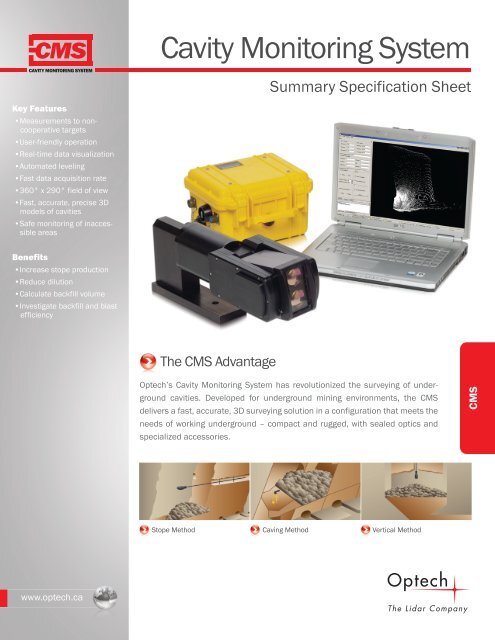
<strong>Cavity</strong> <strong>Monitoring</strong> <strong>System</strong><br />
CAVITY MONITORING SYSTEM<br />
Summary Specification Sheet<br />
Key Features<br />
•Measurements to noncooperative<br />
targets<br />
•User-friendly operation<br />
•Real-time data visualization<br />
•Automated leveling<br />
•Fast data acquisition rate<br />
•360° x 290° field of view<br />
•Fast, accurate, precise 3D<br />
models of cavities<br />
•Safe monitoring of inaccessible<br />
areas<br />
Benefits<br />
•Increase stope production<br />
•Reduce dilution<br />
•Calculate backfill volume<br />
•Investigate backfill and blast<br />
efficiency<br />
The CMS Advantage<br />
Optech’s <strong>Cavity</strong> <strong>Monitoring</strong> <strong>System</strong> has revolutionized the surveying of underground<br />
cavities. Developed for underground mining environments, the CMS<br />
delivers a fast, accurate, 3D surveying solution in a configuration that meets the<br />
needs of working underground – compact and rugged, with sealed optics and<br />
specialized accessories.<br />
CMS<br />
Stope Method Caving Method Vertical Method<br />
www.optech.ca
<strong>Cavity</strong> <strong>Monitoring</strong> <strong>System</strong><br />
CMS<br />
CAVITY MONITORING SYSTEM<br />
The CMS Advantage<br />
The CMS collects thousands of accurately located points that are used to determine a cavity's size, orientation and volume, and to<br />
create detailed engineering drawings. Universally accepted data formats ensure that CMS data can be used in any software workflow.<br />
Developed in the 1980s, and patent-protected since then, the Optech <strong>Cavity</strong> <strong>Monitoring</strong> <strong>System</strong> (CMS) has become synonymous<br />
with underground surveying. With hundreds of systems shipped worldwide, the CMS continues to provide fast, reliable and<br />
efficient scanning and monitoring of underground cavities.<br />
Parameter<br />
V400 Specification<br />
Range capability 200 m @ 20%; 500 m @ 90%<br />
Minimum range<br />
15 cm<br />
Ø 175 6.890<br />
CLEARANCE<br />
ENVELOPE<br />
Horizontal angular range 360°<br />
122<br />
Vertical angular range 290°<br />
Range accuracy<br />
Range resolution<br />
±2 cm<br />
1 mm<br />
Angular accuracy 0.1°<br />
Angular resolution 0.022°<br />
Min step size (azim and elev) 0.25°<br />
Scan time (1 x 1 degree)<br />
6 min<br />
Points per scan (360 x 290 degrees) 52200<br />
Operating temperature<br />
-10° to +50°C<br />
Weight, scanning head<br />
5.4 kg<br />
Weight, battery case<br />
7.6 kg<br />
Wireless connectivity<br />
Yes<br />
Operating power<br />
24 VDC<br />
Scanner diameter<br />
175 mm<br />
Water and dust protection<br />
1<br />
IP65<br />
2<br />
157<br />
Ø 203 7.992<br />
ELEVATION<br />
ENVELOPE<br />
ELEVATION AXIS<br />
319<br />
AZIMUTH AXIS<br />
Optional Accessories<br />
Vertical Insertion Package<br />
Volume Calculation Software<br />
Tripod Mounting Bracket<br />
PC/PDA<br />
Boom + Mast Sets<br />
Backpack<br />
241<br />
398<br />
522<br />
1 Performed under Optech test conditions<br />
2 Designed to meet IP65<br />
E&OE. All specifications subject to change without notice. Printed in Canada. 100329<br />
1 mW 650 nm<br />
Laser Pointer CLASS 2M<br />
2 mW 905 nm<br />
Range Finder CLASS 1<br />
Optech Incorporated<br />
300 Interchange Way, Vaughan, Ontario, L4K 5Z8, Canada<br />
www.optech.ca<br />
Tel: +1 905 660 0808 Fax: +1 905 660 0829<br />
www.optech.ca