Leica GeoMoS Brochure - Leica Geosystems
Leica GeoMoS Brochure - Leica Geosystems
Leica GeoMoS Brochure - Leica Geosystems

You also want an ePaper? Increase the reach of your titles
YUMPU automatically turns print PDFs into web optimized ePapers that Google loves.
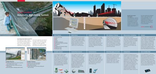
<strong>Leica</strong> <strong>GeoMoS</strong><br />
Automatic Monitoring System<br />
Numerous accidents and disasters in the past have shown the risks that<br />
are associated with large construction projects (e.g. dams, tunnels, bridges,<br />
high-rise buildings, etc.) or natural events (e.g. volcanoes, landslide and<br />
settlement areas). The monitoring of man made structures and dangerous<br />
areas is becoming increasingly important. Monitoring involves periodically and<br />
automatically measuring points in or around an active area to determine the<br />
deformation. It is often necessary to immediately analyze the measured data<br />
and to inform the responsible people when movements exceed set<br />
tolerances. Monitoring and deformation analysis present some of the most<br />
sophisticated challenges in the surveying industry today because they require<br />
the highest accuracy, maximum reliability, automatic measurements<br />
and advanced computation and analysis tools.<br />
Benefit from service<br />
and support<br />
<strong>Leica</strong> <strong>Geosystems</strong>' customers<br />
benefit from service and support<br />
that spans time zones<br />
and geography. Our Active<br />
Customer Care program has<br />
packages to suit your needs,<br />
whether you use our simplest<br />
distance measuring device or<br />
the most sophisticated integrated<br />
solution. Active Customer Care<br />
is a true partnership – it's our<br />
commitment to continue to<br />
provide the level of support and<br />
collaboration you have come to<br />
expect when you put your trust<br />
in <strong>Leica</strong> <strong>Geosystems</strong>.<br />
Multi-Purpose<br />
Multi-Sensor<br />
Scalable & Flexible<br />
SQL Database & Backup<br />
Measurement Scheduling<br />
Analysis<br />
<strong>Leica</strong> Monitoring Software Solutions<br />
<strong>Leica</strong> <strong>GeoMoS</strong> is an open, scalable<br />
and customizable software suitable for<br />
a wide range of monitoring applications.<br />
The <strong>Leica</strong> <strong>GeoMoS</strong> software is<br />
comprised of two main applications<br />
called Monitor and Analyzer. Monitor<br />
is the online application responsible for<br />
the sensor control, collection of data,<br />
computation and event management.<br />
Analyzer is the offline application<br />
responsible for the analysis, visualization<br />
and post-processing of the data.<br />
Construction sites<br />
Roads<br />
Dams<br />
Tunnels<br />
Bridges and Viaducts<br />
High-rise and historical buildings<br />
Foundations<br />
Mines<br />
Landslide and Volcanoes Slopes<br />
Settlement areas<br />
Earthquake areas<br />
Each monitoring project has specific<br />
measurement and accuracy requirements.<br />
The <strong>Leica</strong> <strong>GeoMoS</strong> software<br />
provides a highly flexible monitoring<br />
system that is able to combine<br />
geodetic, geotechnical and meteorological<br />
sensors to match the<br />
needs of your monitoring project.<br />
The <strong>Leica</strong> <strong>GeoMoS</strong> software is highly<br />
customizable allowing you to purchase<br />
only the functionality you require.<br />
The sensor license concept means<br />
that the software scales with the<br />
number and type of sensors you have<br />
connected. Additional functionality<br />
can easily be added later should your<br />
needs change.<br />
<strong>GeoMoS</strong> Monitor stores all measurements<br />
and results in an open SQL<br />
database. The data can be accessed<br />
both locally and remotely using either<br />
<strong>GeoMoS</strong> Analyzer or third party software.<br />
The SQL database is a scalable,<br />
secure and robust data storage system<br />
that supports multi-user access and<br />
automatic data backup.<br />
<strong>GeoMoS</strong> Monitor operates<br />
autonomously providing sophisticated<br />
multi-sensor measurement scheduling.<br />
A wide range of options are available<br />
for system optimization such as<br />
outlier detection, data validation,<br />
filtering and re-measurement to<br />
ensure accurate and reliable data<br />
acquisition.<br />
<strong>GeoMoS</strong> Analyzer can display graphically<br />
and numerically all measurements and<br />
results. Combine the data from multiple<br />
points or sensors in a singlegraph to<br />
check for correlations. The Site Map<br />
shows at a glance the status of your<br />
monitoring project using traffic light<br />
symbols overlaid on a photo or georeferenced<br />
map. <strong>GeoMoS</strong> Analyzer can<br />
also import and export data and be<br />
used for data editing and post processing.<br />
Geodetic Sensors<br />
Geotechnical Sensors<br />
Communication<br />
Event Messaging and Limits<br />
Computation<br />
<strong>Leica</strong> <strong>GeoMoS</strong> Web<br />
<strong>GeoMoS</strong> Monitor<br />
Central monitoring unit for data acquisition<br />
and multiple sensor control<br />
Engine for third party software with open<br />
SQL database<br />
Real-time graphics displaying system status<br />
<strong>GeoMoS</strong> Analyzer<br />
Graphical and numerical analysis<br />
Site map with status information<br />
Data import and export<br />
Quality improvements with data editing and<br />
post processing<br />
<strong>Leica</strong> <strong>Geosystems</strong> range of total<br />
stations, GNSS receivers and<br />
digital levels can be connected to<br />
<strong>Leica</strong> <strong>GeoMoS</strong>. <strong>Leica</strong> total stations are<br />
specially designed for the demanding<br />
requirements of continuous monitoring.<br />
<strong>Leica</strong> <strong>GeoMoS</strong> can be combined<br />
with <strong>Leica</strong> GNSS Spider, for advanced<br />
GNSS monitoring using the latest GPS<br />
and GLONASS technology.<br />
<strong>Leica</strong> <strong>GeoMoS</strong> can interface with<br />
dataloggers that support most<br />
commercially available geotechnical<br />
sensors to measure environmental<br />
effects and conditions. In addition<br />
direct connection to selected meteorological<br />
and geotechnical sensors<br />
is supported. Supplementing the<br />
geodetic measurements with<br />
geotechnical data can help to<br />
understand the reasons for any<br />
detected deformations.<br />
A wide-range of communication<br />
technologies are supported for<br />
sensor control and data acquisition<br />
including cable, bus system, radio,<br />
LAN, WLAN and GSM/GPRS, UMTS and<br />
WiMax. An email, SMS, command line<br />
or external device can inform you<br />
when defined test criteria fail or<br />
various events occur.<br />
<strong>GeoMoS</strong> Monitor computes deformations<br />
and limit checks in real time.<br />
Powerful event management and<br />
messaging capabilities can be used to<br />
notify responsible staff about<br />
important system events, e.g. limit<br />
exceeded, power failure, burglary,<br />
communication to sensor lost etc.<br />
Coordinates and displacements are<br />
computed in your local geodetic system<br />
and the output of one or more sensors<br />
can be modelled with constants,<br />
mathematical functions and/or logic<br />
operators as a so-called 'virtual sensor'.<br />
Measurements to reference points<br />
and/or meteorological data can be<br />
used to correct for atmospheric errors<br />
and changes in the position and<br />
orientation of the total station.<br />
Combine terrestrial and satellite<br />
positioning systems to overcome<br />
problems with unstable control points.<br />
<strong>Leica</strong> <strong>GeoMoS</strong> Web is a web based<br />
application for visualization and analysis<br />
of monitoring data collected by<br />
<strong>GeoMoS</strong> Monitor. Access your monitoring<br />
project anywhere, anytime and<br />
quickly get an overview of the system<br />
status or make detailed analysis of the<br />
data. Host <strong>Leica</strong> <strong>GeoMoS</strong> Web yourself<br />
or have IT and monitoring experts from<br />
<strong>Leica</strong> <strong>Geosystems</strong> host it for you.