Captain Vancouver - Global Bird Photos Collection
Captain Vancouver - Global Bird Photos Collection
Captain Vancouver - Global Bird Photos Collection

Create successful ePaper yourself
Turn your PDF publications into a flip-book with our unique Google optimized e-Paper software.
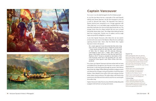
<strong>Captain</strong> <strong>Vancouver</strong><br />
For 10,000 years the land belonged to the First Nations people.<br />
In 1791 Don José María Narváez, commander of the small Spanish<br />
sailing vessel Santa Saturnina, was the first European to ever sail<br />
a vessel on Burrard Inlet waters. The Squamish First Nation at<br />
Elyamu (Jericho) were astounded to see a strange apparition with<br />
“three dead trees” on it, and elderly sages concluded that it was an<br />
island that had broken free from its fastenings beneath the sea. The<br />
younger braves from the village watched and saw men on board<br />
with pallid, almost white, faces. The village elders believed that the<br />
dead were coming back. Narváez was an explorer, and his rough<br />
maps were perfectly intelligible to a seaman.<br />
A year later <strong>Captain</strong> <strong>Vancouver</strong>, after whom the city was named,<br />
arrived on the west coast in His Majesty’s Ship Discovery and began<br />
exploring Burrard Inlet. Here’s what the British Navy <strong>Captain</strong><br />
<strong>Vancouver</strong> wrote in his journal:<br />
On a nearer approach it was discovered that they were a brig<br />
and a schooner, wearing the colours of Spanish vessels of war<br />
... these vessels proved to be the brig Sutil, under command<br />
of Señor Don D. Galiano, with the schooner Mexicana,<br />
commanded by Señor Don C. Valdés. Señor Galiano, who<br />
spoke a little English, informed me that they had sailed from<br />
Nootka on the 5 th of June to complete an examination of the<br />
Gulf of Georgia, which had, in the preceding year 1971, been<br />
surveyed by some Spanish naval officers whose chart they<br />
produced.<br />
On 13 June 1791 <strong>Captain</strong> <strong>Vancouver</strong> and some sailors took two boats<br />
and paddled them through the First Narrows to the eastern end of<br />
Burrad Inlet. As the boats passed through the narrows, First Nations<br />
braves from the village of Whoi-Whoi greeted them in dugout canoes<br />
and showered the strangers with great handfuls of soft white down<br />
feathers. These floated on the surface of the water and gave the first<br />
white visitors a hearty welcome. The sailors slept on the beach at the<br />
easternmost end of Burrard Inlet and left early the next morning for<br />
the mother ship.<br />
<strong>Captain</strong> <strong>Vancouver</strong>’s ship Discovery was a British warship adequately<br />
equipped with the finest surveying instruments.<br />
Opposite Top<br />
Before photography, there was painting.<br />
British Navy <strong>Captain</strong> George <strong>Vancouver</strong> is<br />
depicted on the deck of the Spanish Brig Sutil<br />
in conversation with Don. D. Galiano, off Point<br />
Grey. Distinguished Canadian historical artist<br />
John Innes was commissioned in the midtwentieth<br />
century to recreate this 1792 moment.<br />
Opposite Bottom<br />
Another John Innes oil painting shows<br />
<strong>Captain</strong> <strong>Vancouver</strong> and some sailors<br />
in two small skiffs, accompanied by<br />
friendly local First Nations men in<br />
dugout canoes exploring Burrard Inlet. The<br />
Lions can be seen in the background.<br />
Following Pages<br />
Today’s celebrated marine artist John<br />
Horton of Richmond depicts the same<br />
scene as <strong>Captain</strong> <strong>Vancouver</strong> and his crew<br />
entered the First Narrows to explore Burrard<br />
Inlet and are greeted by the locals.<br />
14 <strong>Vancouver</strong> Exposed: A History in Photographs Early Colonization 15
John 16 Horton <strong>Vancouver</strong> Exposed: A History in Photographs Early Colonization 17
Ustlawn •<br />
(Mission Reserve)<br />
Estahlohk •<br />
(Lonsdale)<br />
Kwahulcha • • Whawhlwry<br />
Uthkyme •<br />
Sahik •<br />
(Moodyville)<br />
• Huphahpai<br />
• Chetchailmun<br />
(Rogers Sugar)<br />
Tlathmahulk •<br />
• KumKumlay<br />
(Hastings Mill)<br />
Kiwahusks •<br />
(Main Street)<br />
• Paapeeak<br />
(Brockton Point)<br />
Squtsahs •<br />
(Deadman's Island)<br />
• Lucklucky<br />
(Gastown)<br />
• Puckahls<br />
(Burrard Street)<br />
• Aun-mayt-sut<br />
(Cambie Street)<br />
• Sahunz<br />
(Prospect Point)<br />
• Chay-thoos<br />
• Ahka-chu<br />
(Beaver Lake)<br />
Lost Lagoon<br />
Ay-tul-shun •<br />
Ay-ay-aul-shun •<br />
(Broughton Street)<br />
Smam-chuze •<br />
(Howe Street)<br />
Snauq •<br />
(Burrard Street)<br />
Chants •<br />
• Slah-Kay-Ulsh<br />
(Siwash Rock)<br />
Staitwouk •<br />
(Second Beach)<br />
• Skwa-yoos<br />
(Kitsilano Beach)<br />
Simsahmuls •<br />
(Bayswater Street)<br />
before the white man came. Burrard Inlet and English Bay were strewn with First Nation villages and<br />
landmarks at the arrival of <strong>Captain</strong> <strong>Vancouver</strong> in 1792. The familiar places were first recorded by City<br />
Archivist James Skitt Matthews in the mid-1930s and were overlaid in 2010 on artist Jim McKenzie’s oil<br />
interpretation of the ancient landscape, showing the continued use of the region’s major sites.<br />
N<br />
W<br />
E<br />
S
looking east from 10,000 feet. The aerial<br />
photographer and author attempted to recreate<br />
Jim McKenzie's oil painting of 1792 to show<br />
the dramatic changes to Greater <strong>Vancouver</strong> in<br />
just over two hundred years. This photograph,<br />
taken from 10,000 feet, shows the damage<br />
from storms. On 19 December 2006 a series<br />
of storms battered Vancovuer with nearhurricane<br />
worce winds that uprooted or simply<br />
snapped 1,000 of Stanley Park’s first growth<br />
Western Red Cedar and Douglas Fir trees in the<br />
vicinity of Prospect Point and Siwash Rock.<br />
Indian Arm<br />
Fraser River<br />
Moodyville<br />
(Sahik)<br />
Second<br />
Narrows<br />
New Brighton<br />
(Huphahpai)<br />
Rogers Sugar •<br />
(Chetchailmun)<br />
Mission Reserve<br />
(Ustlawn)<br />
Lonsdale<br />
(Estahlohk)<br />
Brockton Point<br />
(Paapeeak)<br />
Hastings Mill<br />
(Kumkumly)<br />
Deadman's Island<br />
(Squtsahs)<br />
Gastown<br />
(Luck-lucky)<br />
Burrard Street<br />
(Puckahls)<br />
Main Street<br />
(Kiwahusks)<br />
Cambie Street<br />
(Aun-mayt-sut)<br />
Lumberman's Arch<br />
(Whoi-Whoi / Xwayxway)<br />
First Narrows<br />
Beaver Lake<br />
(Ahka-chu)<br />
Prospect Point<br />
(Sahunz)<br />
Stanley Park<br />
(Slahkayulsh)<br />
Lost Lagoon<br />
Second Beach<br />
(Staitwouk)<br />
English Bay<br />
(Ay-tul-shun)<br />
Broughton Street<br />
(Ay-ay-aul-shun)<br />
Swiash Rock<br />
(Slah-Kay-Ulsh)<br />
N<br />
W<br />
E<br />
S