Eliza S. Bradley - University of California, Santa Barbara
Eliza S. Bradley - University of California, Santa Barbara
Eliza S. Bradley - University of California, Santa Barbara
Create successful ePaper yourself
Turn your PDF publications into a flip-book with our unique Google optimized e-Paper software.
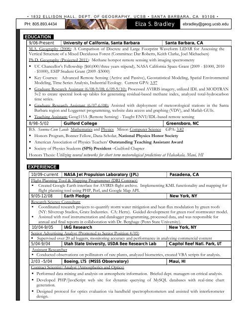
• 1832 ELLISON HALL, DEPT. OF GEOGRAPHY, UCSB • SANTA BARBARA, CA 93106 •<br />
PH: 805.893.4434<br />
<strong>Eliza</strong> S. <strong>Bradley</strong><br />
ebradley@geog.ucsb.edu<br />
EDUCATION..<br />
9/06-Present <strong>University</strong> <strong>of</strong> <strong>California</strong>, <strong>Santa</strong> <strong>Barbara</strong> <strong>Santa</strong> <strong>Barbara</strong>, CA<br />
M.A. Geography (2008): A Comparison <strong>of</strong> Discrete and Large Footprint Waveform LiDAR for Assessing the<br />
Vertical Structure <strong>of</strong> a Mixed Deciduous Forest (Committee: Dar Roberts, Keith Clarke, Joel Michaelsen)<br />
Ph.D. Geography (Projected 2011): Methane hotspot remote sensing with imaging spectrometry<br />
• UC Chancellor’s Fellowship ($60,000/three years stipend), NASA <strong>California</strong> Space Grant (2009 - $1000, 2010<br />
- $1000), ESIP Student Grant (2009 -$3000)<br />
• Key Courses: Advanced Remote Sensing (Active and Passive), Geostatistical Modeling, Spatial Environmental<br />
Modeling, Time Series Analysis, Industrial Ecology. Current GPA: 3.97<br />
• Graduate Research Assistant (6/08-9/08; 6/09-9/10): Processed AVIRIS imagery, utilized IDL and MODTRAN<br />
5v2 to create spectral look-up tables for generating residual-based methane index, analyzed total-hydrocarbon<br />
time series.<br />
• Graduate Research Assistant (6/07-6/08): Assisted with deployment <strong>of</strong> meteorological stations in the <strong>Santa</strong><br />
<strong>Barbara</strong> region and Loggernet programming, website data access and graphing (VDV), and Matlab GUIs.<br />
• Teaching Assistant: Geog115A (Remote Sensing) - Taught ENVI/IDL-based remote sensing<br />
8/98–5/02 Guilford College Greensboro, NC<br />
B.S. Summa Cum Laude Mathematics and Physics Minor: Computer Science GPA: 3.82<br />
• Honors Program, Bonner Fellow, Dana Scholar, National Physics Honor Society<br />
• American Association <strong>of</strong> Physics Teachers’ Outstanding Teaching Assistant Award<br />
• Society <strong>of</strong> Physics Students (SPS) President –Guilford Chapter<br />
Honors Thesis: Utilizing neural networks for short term meteorological predictions at Haleakala, Maui, HI<br />
EXPERIENCE..<br />
10/09-current NASA Jet Propulsion Laboratory (JPL) Pasadena, CA<br />
Flight Planning Tool & Mapping Programmer (DRI Contract)<br />
• Created Google Earth interface for AVIRIS flight archive. Implementing KML functionality and mapping for<br />
flight planning tool using PHP, Perl, and Google Map API.<br />
9/05-12/08 Earth Pledge New York, NY<br />
Research Science Consultant<br />
• Coordinated research projects to quantify storm water mitigation and heat-flux modulation by green ro<strong>of</strong>s<br />
(NY: Silvercup Studios, Gratz Industries. CA: Hertz). Guided development for green ro<strong>of</strong> stormwater model.<br />
• Assisted with ro<strong>of</strong> instrumentation and datalogger programming, processed data, and was responsible for<br />
annual and final reports in collaboration with Dr. Berghage (Penn State <strong>University</strong>).<br />
10/04-9/05 IAG Research New York, NY<br />
Senior Advertising Analyst (Promoted to Senior Position 4/05)<br />
• Supervised over 20 ad loggers, monitoring accuracy and performance in analyzing commercial content<br />
5/04-9/04 Utah State <strong>University</strong>, USDA Bee Research Lab Capitol Reef Natl. Park, UT<br />
Assistant Researcher<br />
• Conducted observations on pollinators <strong>of</strong> rare plants, analyzed biometrics, created VBA scripts for analysis.<br />
2/03 –5/04 Boeing, LTS (MSSS Observatory) Maui, HI<br />
Contract Scientist/Analyst (Atmospherics and Optics)<br />
• Performed data mining and analysis on atmospheric information. Briefed dept. managers on critical analysis.<br />
• Developed PHP/JavaScript web site for dynamic querying <strong>of</strong> MySQL databases with real-time chart<br />
generation.<br />
• Designed protocol for optics evaluation via handheld spectrophotometers and assisted with interferometer<br />
design.
• 1832 ELLISON HALL, DEPT. OF GEOGRAPHY, UCSB • SANTA BARBARA, CA 93106 •<br />
<strong>Eliza</strong> S. <strong>Bradley</strong><br />
TECHNICAL QUALIFICATIONS..<br />
Programming: MATLAB, IDL, PHP, Perl, Javascript, Processing, C++, HTML, Visual BASIC, SQL (MySQL)<br />
S<strong>of</strong>tware: ENVI, ArcGIS, Loggernet, MODTRAN 5.0, Vista Data Vision, DIRSIG, RSView, Labview, SPSS,<br />
AutoCAD, Flowmaster, HEC-RAS, MS: Word, Excel, Access, PowerPoint; Macromedia: Dreamweaver, Flash, and<br />
Fireworks<br />
Operating Systems: Unix, Mac, Windows<br />
PROFESSIONAL MEMBERSHIPS..<br />
American Geophysical Union<br />
American Society for Photogrammetry and Remote Sensing<br />
Association <strong>of</strong> American Geographers<br />
Green Ro<strong>of</strong>s for Healthy Cities<br />
WORKSHOPS..<br />
HyspIRI Science Workshop – 2009, 2010<br />
<strong>California</strong> Air Resources Board ARCTAS - 2009<br />
Digital Imaging and Remote Sensing Image Generation Training -2008<br />
Airborne Visible/Infrared Imaging Spectrometer Workshop -2007<br />
Green Ro<strong>of</strong> Design 101 Course -2006<br />
PUBLICATIONSS<br />
In Preparation<br />
<strong>Bradley</strong>, E. Roberts, D.A., & Roth, K.L. (In Prep.). A comparison <strong>of</strong> discrete and large footprint waveform LiDAR for<br />
assessing the vertical structure <strong>of</strong> a mixed deciduous forest.<br />
In Review<br />
<strong>Bradley</strong>, E. Roberts, D.A., Dennison, P., Green, R., Eastwood, M., Lundeen, S., McCubbin, I., & Leifer, I. (In Review).<br />
Google Earth and Google Fusion Tables in support <strong>of</strong> time-critical collaboration: Mapping the Deepwater Horizon<br />
oil spill with the AVIRIS airborne spectrometer.<br />
Accepted - Published<br />
<strong>Bradley</strong>, E., Leifer, I., Roberts, D.A., Dennison, P.E., & Washburn, L. (In Press). Detection <strong>of</strong> marine methane emissions<br />
with AVIRIS imaging spectrometer band ratios. Geophysical Research Letters<br />
<strong>Bradley</strong>, E., & Clarke, K. (2011). Outdoor webcams as geospatial sensor networks: Challenges, issues and opportunities.<br />
Cartography and Geographic Information Science, 38, 1, 5-22.<br />
Roberts, D.A., <strong>Bradley</strong>, E., Roth, K., Eckmann, T., & Still, C. (2010). Linking physical geography education and research<br />
through the development <strong>of</strong> an environmental sensing network. Journal <strong>of</strong> Geoscience Education, 58, 262-274.<br />
Clark, R.N., Swayze, G.A., Leifer, I. Livo, K.E., Kokaly, R., Hoefen, T., Lundeen, S., Eastwood, M., Green, R.O., Pearson,<br />
N., Sarture, C., McCubbin, I., Roberts, D., <strong>Bradley</strong>, E., Steele, D., Ryan, T., Dominguez, R., and the Airborne<br />
Visible/Infrared Imaging Spectrometer (AVIRIS) Team. (2010). A method for quantitative mapping <strong>of</strong> thick oil<br />
spills using imaging spectroscopy: U.S. Geological Survey Open-File Report 2010–1167, 51 p.<br />
<strong>Bradley</strong>, E., Toomey, M., Still, C., & Roberts, D. (2010). Multi-scale sensor fusion via online interface: Integrating GOES,<br />
MODIS, and webcam imagery for environmental monitoring. IEEE Journal <strong>of</strong> Selected Topics in Applied Earth<br />
Observations and Remote Sensing, 3, 497-506.<br />
<strong>Bradley</strong>, E., Leifer, I. & Roberts, D.A. (2010). Long-term monitoring <strong>of</strong> a marine geologic methane source by a coastal air<br />
pollution station in Southern <strong>California</strong>. Atmospheric Environment, 44, 4973-4981.<br />
Roberts, D.A., <strong>Bradley</strong>, E., Cheung, R., Leifer, I., Dennison, P.E., & Margolis, J. (2010). Mapping methane emissions from<br />
a marine geological seep source using imaging spectrometry. Remote Sensing <strong>of</strong> Environment, 114, 592-606.<br />
<strong>Bradley</strong>, E., Still, C., & Roberts, D. (2010). Design <strong>of</strong> an image analysis website for phenological and meteorological<br />
monitoring. Environmental Modelling & S<strong>of</strong>tware. 25, 107-116.<br />
<strong>Bradley</strong>, E., Roberts, J.L.C., Bradford, L.W., Skinner, M.A., Nahrstedt, D.A., Waterson, M.F., & Kuhn, J.R. (2006).<br />
Characterization <strong>of</strong> meteorological and seeing conditions at Haleakala. Publications <strong>of</strong> the Astronomical Society <strong>of</strong><br />
the Pacific, 118, 172-182.
• 1832 ELLISON HALL, DEPT. OF GEOGRAPHY, UCSB • SANTA BARBARA, CA 93106 •<br />
<strong>Eliza</strong> S. <strong>Bradley</strong><br />
PRESENTATIONS..<br />
Thorpe, A.K., <strong>Bradley</strong>, E.S., Funk, C., Roberts, D.A., Leifer, I., & Dennison, P.E. (2011). Mapping methane from<br />
terrestrial hydrocarbon seepage using AVIRIS. In, Association <strong>of</strong> American Geographers Annual Meeting. Seattle,<br />
WA<br />
<strong>Bradley</strong>, E., Toomey, M.P., Roberts, D.A., & Still, C.J. (2010). New tools for viewing spectrally and temporally-rich<br />
remote sensing imagery. In, American Geophysical Union Fall Meeting. San Francisco, CA<br />
Thorpe, A.K., <strong>Bradley</strong>, E.S., Funk, C., Roberts, D.A., Leifer, I., Dennison, P.E., & Margolis, J. (2010). Mapping methane<br />
from marine and terrestrial hydrocarbon seepage using AVIRIS. In, American Geophysical Union Fall Meeting.<br />
San Francisco, CA<br />
<strong>Bradley</strong>, E., Still, C., Roberts, D.A., & Toomey, M. (2010). PanOpt: An Interactive Website for GOES, MODIS, and<br />
Webcam Time-Series Imagery. In, ESIP Federation Winter Meeting, 5-7 January, 2010. Washington, DC<br />
<strong>Bradley</strong>, E., Leifer, I., Roberts, D., Dennison, P.E., Margolis, J., Moritsch, M., Diskin, G., & Sachse, G. (2009). Multi-scale<br />
monitoring <strong>of</strong> a marine geologic methane source in the <strong>Santa</strong> <strong>Barbara</strong> Channel using imaging spectrometry,<br />
ARCTAS-CARB in situ sampling and coastal hourly total hydrocarbon measurements. In, American Geophysical<br />
Union Fall Meeting. San Francisco, CA<br />
Carbone, M.S., Ambrose, A., <strong>Bradley</strong>, E., Boot, C.M., Dawson, T.E., Schimel, J.P., Schaeffer, S.M., Still, C.J., & Williams,<br />
A.P. (2009). Moisture controls on plant and microbial contributions to soil respiration. In, American Geophysical<br />
Union Fall Meeting. San Francisco, CA<br />
Roth, K.L., Haggerty, B.P., <strong>Bradley</strong>, E., Toomey, M.P., Mazer, S.J., & Roberts, D. (2009). Towards a Phenological<br />
Assessment <strong>of</strong> <strong>California</strong>: Integrating Multiple Data Sources and the Implications for Statewide Analyses. In,<br />
American Geophysical Union Fall Meeting. San Francisco, CA<br />
Carbone, M.S., Ambrose, A., <strong>Bradley</strong>, E., Boot, C.M., Dawson, T.E., Schimel, J.P., Schaeffer, S.M., Still, C.J., & Williams,<br />
A.P. (2009). Plant and microbial contributions to pine forest soil respiration: moisture controls in a Mediterranean<br />
climate. In, The 8th International Carbon Dioxide Conference. Jena, Germany<br />
Roth, K.L., <strong>Bradley</strong>, E., Toomey, M., Roberts, D., & Still, C. (2009). Using the PanOpt Interface for Linking Measures <strong>of</strong><br />
Seasonal Greenness Across Spatial Scales in a Mediterranean-climate Ecosystem. In, Phenology Research and<br />
Observations <strong>of</strong> Southwest Ecosystems Symposium (PROSE). Tucson, AZ<br />
Carbone, M.S., Ambrose, A., <strong>Bradley</strong>, E., Boot, C.M., Dawson, T.E., Schimel, J.P., Schaeffer, S.M., Still, C.J., & Williams,<br />
A.P. (2009). Moisture controls on plant and microbial contributions to soil respiration in coastal <strong>California</strong> pine<br />
forests. In, Ecological Society <strong>of</strong> America Annual Meeting. Albuquerque, New Mexico<br />
Leifer, I., Roberts, D., <strong>Bradley</strong>, E., Bovensmann, H., Buchwitz, M., Cheung, R., Diskin, G., Luyendyk, B., Dennison, P.E.,<br />
Margolis, J., Miller, C., Sachs, T., & Sachse, G. (2009). AVIRIS and MASTER Methane Remote Sensing <strong>of</strong><br />
Heterogeneous Marine Sources. In, HyspIRI Science Workshop. Pasadena, CA<br />
<strong>Bradley</strong>, E., Toomey, M., Still, C., Roberts, D. (2009). Web Services for Digital Repeat Photography: Integration with<br />
Satellite Imagery. ESIP Summer Conference 7-10 July 2009. <strong>Santa</strong> <strong>Barbara</strong>, CA.<br />
Leifer, I., <strong>Bradley</strong>, E., Roberts, D., Cheung, R., Margolis, J., & Miller, C. (2009). Methane Remote Sensing from Maritime<br />
Sources. In, Developing Long Term International Collaboration on Methane Hydrate Research and Monitoring in<br />
the Arctic Region. Texel, The Netherlands: Royal Netherlands Institute for Sea Research and Naval Research<br />
Laboratory.<br />
Leifer, I., <strong>Bradley</strong>, E., Roberts, D., Cheung, R., Margolis, J., & Miller, C. (2009). Remote Sensing and Validation <strong>of</strong><br />
Methane from Natural Marine Seeps, Feedlots, and Rice Paddies. In, ARCTAS Science Team Meeting. Virginia<br />
Beach, VA.<br />
<strong>Bradley</strong>, E., Still, C., & Roberts, D.A. (2009). Web-Based Image Analysis For Phenology and Meteorology<br />
Characterizations. In, Association <strong>of</strong> American Geographers Annual Meeting. Las Vegas, NV<br />
<strong>Bradley</strong>, E., Roberts, D.A., Roth, K.L., & Parker, G. (2008). Forest Vertical Structure from Discrete Lidar, LVIS, and the<br />
Ideal Tree Distribution Model. In, Eos Trans. AGU, 89(53), Fall Meeting Suppl. San Francisco, CA<br />
Roth, K.L., Roberts, D.A., <strong>Bradley</strong>, E., Parker, G., & Dennison, P.E. (2008). A Combined Hyperspectral and Lidar Remote<br />
Sensing Analysis <strong>of</strong> Forest Canopy Variations for Improving Carbon Balance Estimation. In, Eos Trans. AGU,<br />
89(53), Fall Meeting Supplement. San Francisco, CA<br />
Dennison, P.E., <strong>Bradley</strong>, E., & Roberts, D. (2008). Detecting Fire and Methane Using Hyperspectral Shortwave Infrared<br />
Remote Sensing Data. In, GEOINT Nashville, TN<br />
<strong>Bradley</strong>, E., Roberts, D.A., Roth, K.L., & Parker, G. (2008). A Comparison <strong>of</strong> Discrete and Large Footprint Waveform<br />
Lidar for Assessing the Vertical Structure <strong>of</strong> a Mixed Deciduous Forest In, Association <strong>of</strong> American Geographers<br />
Annual Meeting. Boston, MA
• 1832 ELLISON HALL, DEPT. OF GEOGRAPHY, UCSB • SANTA BARBARA, CA 93106 •<br />
<strong>Eliza</strong> S. <strong>Bradley</strong><br />
Roth, K.L., Roberts, D.A., <strong>Bradley</strong>, E., Dennison, P.E., Natour, B., & Parker, G. (2008). Combining Lidar and<br />
Hyperspectral Data for Improved Carbon Estimation in a Temperate Deciduous Forest. In, Association <strong>of</strong> American<br />
Geographers Annual Meeting. Boston, MA<br />
Roberts, D.A., Still, C., <strong>Bradley</strong>, E., & Eckmann, T. (2008). Innovative use <strong>of</strong> Environmental Data in Geographic<br />
Education. In, Association <strong>of</strong> American Geographers Annual Meeting. Boston, MA<br />
<strong>Bradley</strong>, E., & Adelberger, R. (2002). Utilizing Neural Networks for Meteorological Prediction and Risk Analysis at the<br />
AEOS Observatory. In, National Conference on Undergraduate Research Whitewater, WI


