The new seaman's guide and coaster's companion containing in I ...
The new seaman's guide and coaster's companion containing in I ...
The new seaman's guide and coaster's companion containing in I ...

Create successful ePaper yourself
Turn your PDF publications into a flip-book with our unique Google optimized e-Paper software.
t/<br />
ß . il<br />
vi<br />
8.37<br />
Tim<br />
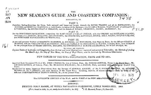
NEW SEAMAN'S GUIDE AND COASTER'S COMPANION:<br />
CONTAINING, IN<br />
PART 1.<br />
Complete Sail<strong>in</strong>g-Directions for Ships, both outward <strong>and</strong> homeward bound, throng« the RIVER THAMES und all its ENTRANCES; the<br />
Bl.'ITISH <strong>and</strong> 'BRISTOL CHANNELS, 01, both Coasts, <strong>in</strong>c-ludiiiK'all t ho Harbours; the- COAST of WALES; W.liST COAST of MNGLAKU W<br />
LIVERPOOL; the SOUTH COAST of IRELAND; aud the Isl<strong>and</strong>s of SCILLY, GUERNSEY, JERSEY, ALDERNEY, See. £~<br />
PART n.<br />
For the NORTHERN NAVIGATION : compris<strong>in</strong>g the EAST COAST e.f GREAT BRITAIN, with the ORKNEY <strong>and</strong> SHETLAND ISLANDS;<br />
IlH? Coasts »f H ANDERS, HOLLAND, aird GERMANY; the NOUTI1 SEA, KATTEGAT, SOUND, BELT, BALTIC, GULF of FINLAND,<br />
<strong>and</strong> NORTHERN NAVIGATION to the WHITE-SKA.<br />
PART III.<br />
Л <strong>new</strong> <strong>and</strong> accurate TABLE of MAGNETIC BKARINGS, or COURSES, <strong>and</strong> DISTANCES, from Place to Place, for the different COASTS of<br />
EUROPE, with the VARIATIONS of the NEEDLE: Also* a <strong>new</strong> TAULE «f the DISTANCES, by WATER, <strong>in</strong> Nautie Miles, from LONDON<br />
to the iiriueipal Ports of GREAT BRITAIN, IRELAND, the CONTINENTS of EUROPE <strong>and</strong> AMERICA, the WEST INDIES, &.e.<br />
• TO WHICH ЛКЕ SUBJ01NEP<br />
Copious Tables i>fLatitudes <strong>and</strong> Ijongit tides, f ra<strong>in</strong> t/ie liest und Ijittst Observai ions ; imprcrcfd <strong>and</strong> corrected Tide-tables; the Met/tods-uffliidii<br />
the ûïuoifs Age, the l<strong>in</strong>y of''New Moon, the Time iif Hi^ti Water, und tic Latitude by. Mcridiunal O.uscrw,tion.<br />
ALSO,<br />
NEW TABLES OF THE SUN's DECLINATION, FROM ISOG TO 1821..<br />
-j<br />
Improved from tive orip<strong>in</strong>al Work of Mr. JOHN CITANDI.F.Il, bte of Orfurd, Pilot; Mr. M UK DO DOWNIE, Master <strong>in</strong> .<br />
UEORGE EUNSON, of Orkney, Pilot; Mi. MURDOCH M'KENZIE; Mr. J.D1STON, Pilot; <strong>and</strong> many<br />
Pilots/<br />
Ausmenlprt Ъу many important Observations from the Surreys of ADMIRAL KNIGHT; of Mr. T. FOTH<br />
MORRISON, Mr. T. STOKES, <strong>and</strong> other Masters, of the Hoyal Navv. Includ<strong>in</strong>g, likewise, all ttccut Ai<br />
dififurcnt CORPORATIONS of TRINITY-HOUSE, &c., to the jircsent Ti.nc.<br />
вжв! 24эд\у ; Mr.<br />
' Waiters 'Und<br />
• • -<br />
<strong>The</strong> FIFTEENTH EDITION of the Work, <strong>and</strong> the FIRST of the NEW ARRANGEA<br />
LONDON:.<br />
PRINTED ГО11 P. MASON, AT STEEL's NAVIGATION-WAREHOUSE-, LITTLE TOWER-HILL. 180
National Oceanic <strong>and</strong> Atmospheric Adm<strong>in</strong>istration<br />
Rare Books from 1600-1800<br />
ERRATA NOTICE<br />
One or more conditions of the orig<strong>in</strong>al document may affect the quality of the<br />
image, such as:<br />
Discolored pages<br />
Faded or light <strong>in</strong>k<br />
Bid<strong>in</strong>g <strong>in</strong>trudes <strong>in</strong>to text<br />
This has been a co-operative project between NOAA central library, the Climate<br />
Database Modernization Program, National Climate Data Center (NCDC) <strong>and</strong> the<br />
NOAA 200th Celebration. To view the orig<strong>in</strong>al document, please contact the<br />
NOAA Central Library <strong>in</strong> Silver Spr<strong>in</strong>g, MD at (301) 713-2607 x 124 or at<br />
Library.Reference@noaa.gov<br />
HOV Services<br />
Imag<strong>in</strong>g Contractor<br />
12200 Kiln Court<br />
Beltsville,MD20704-1387<br />
April 8, 2009
U S.C. A ö SURVEY<br />
I 1 1 и ,(|Ч<br />
. .<br />
4111 1 f III III. I II »l i I tl| II II J<br />
*Ш& B0ök te the Property of ifte<br />
У, S/COAST AND"GEODETIC SURVEY,<br />
<strong>and</strong> rnust be carried on Bock Inventory .<br />
if not returned before tha Expiration.-.L c'<br />
•of the Calendar Year. ^Г ^
Cl
ГВО5ГТГ.ЧР1ЕГЕ ТО ТЛЕ XE<br />
4.УД TOASTERS<br />
Jtskar Ль/Л/. l
TO THE MASTERS OF TUE BRITISH NAVY,<br />
Л CLASS OF OFFICERS WHOSE LIBERALITY HAS PARTICULARLY CONTRIBUTED то ITS PRESENT STATE OF<br />
J M PRO V P. MF, NT, THIS NEW, .EN LAUG KD, AND CO IMl ЕСТ К I), 1ÍD IT! O N OF TU li ' SüAul A N's GUIDE' IS, AS<br />
A TESTIMONY OF G u AT n u IM-:, MOST IÍLSPECTFULLY DEDICATED.<br />
CONTENTS.<br />
<strong>The</strong> reader is particularly requested to correct with his pen, or attend to, the additions <strong>and</strong> corrections which are noticed at the conclusion<br />
of the work.<br />
PART I.—RIVER THAMES, BRITISH CHANNEL, Sec.<br />
NS /or the RIVER THAMES, /)-п;л London to the<br />
Е<br />
Л'ит<br />
KIVKR Ali.DWAY, from C/iallium to tlir Norc - -• - '- - - - 7<br />
J''/чш the Is 1 on F., through l<strong>in</strong>; Fiw Faihmii ana South Channels, to<br />
tkc A'lU'/A Foi-i'ff!llll - - - - - - - - - - ; - - - 10<br />
D<strong>in</strong>t-lions/or t<strong>in</strong>- EAST SVVUT.K - - - - - - - - - - - 1'j<br />
.i'Voi» //к. 1 NiiRE, through tht: УнЬ, Oa~i', <strong>and</strong> Queen's Channels, to<br />
Hit Nor!/i Fardnnd 13<br />
Pro;» lhe. No <strong>in</strong> ч FOÍÍEI.AÍÍD, t/iruugh Ihc Gull Sircam, <strong>in</strong>to the<br />
DOWNS, <strong>and</strong> to Hiuntgate - - - - - - - - - - - - IG<br />
DIRECTIONS for the КОПТИ SIDE of the BRITISH<br />
CHANNEL.<br />
Dowxs tu SrrririiAD - - - - - - - - - - - - - - 21<br />
&,>itkeu,i, the hie »f Wight, Needles, SfC. to Paale 26<br />
i'r'Kn HUXNO.-F, In St. Alduii'f Jit'afl, Portl<strong>and</strong>, Li/тс, Rtmouth,<br />
Toib::y, Dartmouth, <strong>and</strong> Hie. Start - - - - • - ' - .< - 34<br />
Fru'a Hie SI/.II.T i
CONTENTS.<br />
PART IL—CHANNELS of the RIVER THAMES, <strong>and</strong> the NORTHERN NAVIGATION.<br />
DIRECTIONS for lhe DIFFERENT CHANNELS,rf the RirER<br />
THAMES, nnd.bctwtxn ORFORD-NESÜ und the NORTH-<br />
FORELAND.<br />
PACT;<br />
From the Noimi FOHELAND, through the South Channel to the<br />
AW - - .----•- - _ - . - - - - 104<br />
From the North Forel<strong>and</strong>, through the Queers <strong>and</strong> Nob Channels,<br />
106<br />
to the 'Nore ----<br />
From the North Forel<strong>and</strong>, round the Long Sund-lifad, to the East<br />
Endof the Gunjlcet - - - - - 108<br />
From //fcNonr., through iAeSwiN <strong>and</strong> KING'S CHANNEL, to the<br />
East End of the Gunjlcet - .- - -.- - -.- - - - 10Í)<br />
From the East End of the GUNFT..EET, through the Sttdicny, to<br />
HoaLE-y ВЛУ tuid O'rford-ness; tlicnce to Harwich, und over the<br />
Naze, <strong>in</strong>to I he. Wallet - -'- - - - - -- --- -112<br />
Directions for sail<strong>in</strong>i! ont of lhe K<strong>in</strong>g's Channel, either with<strong>in</strong> or<br />
tothesout/iTfardofi/ieShipirash - - - - - - - - - - 1 1 8<br />
Fmiii Hnslci/ lim/, imdfnim the Gnnfleet liuoy, round the Long<br />
S<strong>and</strong>-head, to Ike DOMIIS. - - - - - - - - - - - - 1 1 8<br />
TAn EASTERN COASTS of GREAT BRITAIN, from ORVORD-<br />
' NEKS-<strong>in</strong> the PEXTLAA'D FRITH; <strong>and</strong> the ISLANDS
JT<br />
CONTENTS.<br />
DIRECTIONS/br SHIPS TlETUTïNTNO/row t„e NORTHWARD,<br />
<strong>and</strong> ùji the lUVEU THAMES.<br />
<strong>The</strong><br />
ГАОГ.'<br />
OBSERVATIONS on a CURRF.NT beta-ген Кагн-ву <strong>and</strong> the Orkneys,<br />
TA e NAZI; of NOJIWAY, t* the HJVEII I'IIAMES «ml BÄIIISII<br />
23G<br />
PAG?!<br />
Jîivcr Thames, from llie. Nore to T.ondon 242<br />
Т1ПE TABLE,/«/гЛе Ko<strong>in</strong>n S£A, .oil tlie Days of the Moon's<br />
Full imd Change 246<br />
LATJTUDKS <strong>and</strong> IX)NGITUDES of Places <strong>in</strong> the NORTH<br />
SI;AS, BALTIC, und Gui.t ')/' I'ISLAND 2)8<br />
PART III.—<strong>The</strong> MAGNETIC-BEAÍUNGS or COURSES, <strong>and</strong> the DISTANCES <strong>in</strong> NAUTIC MILES,<br />
from Place to Place, on the difrereut COASTS of EUROPE, with other TABLES, Sec.<br />
SECTION I,— THE BRITISH CHANNEL, BAY OF BISCAY,<br />
SPAIN, PORTUGAL, AND MEDITERRANEAN SKA.<br />
. 1>A6E<br />
Jitter Thèmes, Doœns, <strong>and</strong> British Channel . . . . : • • 249<br />
f<strong>in</strong>i/ of Biscay ................. 2.Î3<br />
ÍAipf Fiaislerrc, 4'-<br />
Ycar, the. Föntet, <strong>and</strong> M.tv<strong>in</strong>'s Ace s also the Moaif s South<strong>in</strong>g,<br />
<strong>and</strong> the .Tiae nf Hii'fi Wuttr on every Day <strong>in</strong> tiic Year . .<br />
RULE for f J iiJ)l Ml t /ic LATITUDE ,;f a Ship at Set,, or<br />
«/" ы 1'litcc on iS/iojr , from the observed Altitude of the Sun,<br />
rihcn on the Meridian ............<br />
TAULES- f J)J1> und KEFRACTTON .......<br />
«72<br />
TAltLES-.uf the SU'N'S DECLINATION f ют 1800 to 1U'>1373<br />
J'ariulivii f tile Sun's Decl<strong>in</strong>ation ........ . ,<br />
ofig<br />
309
GENERAL OBSERVATIONS.<br />
%* Throughout this Volume, unless where otherwise expressed, the COURSKS <strong>and</strong> BEARINGS are by the Compass. <strong>The</strong><br />
Variation, accord<strong>in</strong>g to the latest observations, is as follow :—1. In the BRITISH CHANNEL, from the Downs to Spithead,.<br />
24 degrees, West; from Spitheud to Plymouth, 24 to 20'degrees; from Plymouth to the South of Irel<strong>and</strong>, 26 to 28 degrees;<br />
from Irel<strong>and</strong> to Brest, 28 to 25 degrees; <strong>and</strong>, from Brest to Calais, 25 to 23 degrees.—2. In the NORTH SEA, &c. from the<br />
Thames Mouth to Whitby, 24 to 25 decrees; from Whitby to the Orkneys, 23 to 27 degrees; to the N. K. of the Orkneys,<br />
25 to 29 degrees: Downs to the Scheid, 22 degrees; Scheid to the Kattegat, 22 to 20 degrees; <strong>in</strong> the Kattegat, ]») to.IS<br />
degrees; Baltic, 18 to 15 degrees; <strong>and</strong>, Gulf of F<strong>in</strong>l<strong>and</strong>, from 14 to 10 degrees.<br />
<strong>The</strong> Sound<strong>in</strong>gs, generally, arc those at low water, spr<strong>in</strong>g tides.<br />
PART I.'<br />
RIVER THAMES, BRITISH CHANNEL, &c.<br />
DIRECTIONS far sail<strong>in</strong>s; down the RIVER THAMES,/?» LONDON to the NORE; <strong>and</strong> down the RIVER MEDWAY, from<br />
CHATHAM to the NoiiE; <strong>and</strong> t/tfnce, <strong>in</strong>clud<strong>in</strong>g the EAST SWALE, through the SOUTH <strong>and</strong> QUEEN's CHANNELS<br />
to the DOWNS.<br />
ГОПТ OF LONDON.<br />
ÏÏFORE we proceed to L'ivc directions for navigat<strong>in</strong>g the River<br />
Thames, it may not be improper to premise, that the jurisdiction<br />
ftir the conservancy of this river, with the waters of Medway, <strong>and</strong> the<br />
fisheries there<strong>in</strong>, is one of the most ant lent <strong>and</strong> honourable privileges<br />
of the. city 'if London: the property n f these rivers, mid of the rivu-<br />
Jt-ts which full <strong>in</strong>to them, their fish, <strong>and</strong> the soil beneath, with<strong>in</strong> certa<strong>in</strong><br />
boundaries 4 j hav<strong>in</strong>g been, from time immemorial, vested <strong>in</strong> its<br />
corporation, <strong>and</strong> confirmed to the same by royid d<strong>in</strong>ners <strong>and</strong> acts of<br />
parliament.<br />
In consequence of this right of jurisdiction, the legislature have<br />
• <strong>The</strong>se Louudariet are sliowti iu Steel's <strong>new</strong> Charts of the Thames <strong>and</strong> Meihvay.<br />
placed the shipp<strong>in</strong>g of the port of London, <strong>in</strong>clud<strong>in</strong>g the <strong>new</strong> canal at,<br />
the Islu of Dogs, under the regulations of harbour musters, appo<strong>in</strong>ted<br />
by the corporation. <strong>The</strong> dock masters of. the New London <strong>and</strong> West<br />
India docks arc also cmpowed to direct the moor<strong>in</strong>g, ixc. ai'all vessels<br />
with<strong>in</strong> 200 yards of the entrance of the docks, &rc. <strong>and</strong> mnv enforce<br />
their orders under certa<strong>in</strong> penalties. It is therefore requisite, that<br />
seamen should be acqua<strong>in</strong>ted with these particulars, as a yuidauce<br />
for their conduct whilst <strong>in</strong> the port.<br />
• Complete abstracts of t<strong>in</strong>; acts, regulat<strong>in</strong>g the. shipp<strong>in</strong>g <strong>in</strong> the jiew<br />
docks, with tables of the rates or dues payable there<strong>in</strong>, AÏC .conta<strong>in</strong>ed<br />
<strong>in</strong> the <strong>new</strong> edition of Steel's " Shipmuticr's Assistant <strong>and</strong> Owncr't Manna/."<br />
В<br />
VIKF.C-
DIRECTIONS FOR THE RIVER THAMES.<br />
DIRECTIONS for the RIVER THAMESfrom LONDON to the mud stretches from Cuckold'» Po<strong>in</strong>t, nearly half-river over, towards<br />
NORE.<br />
[Jmchouse-liole, <strong>The</strong> elib-tiilu sots very strongly from the Pool <strong>in</strong>to the<br />
Hole; just below which, at a short distance from the east shore, is á,<br />
f I "'IDE. <strong>The</strong> time of flow<strong>in</strong>g <strong>and</strong> the vertical ris<strong>in</strong>g of the ti3e, rock of 4 or5 feet\tater. In this reach are 10 or 11 -feet, <strong>and</strong> <strong>in</strong> L<strong>in</strong>ielouse-hole<br />
X on the full <strong>and</strong> change days of the moon, <strong>in</strong> the River Thames,<br />
16 feet, at low water. But there is u-'&liift<strong>in</strong>g bank near the<br />
are nearly as follow, viz. at London-bridge, three-quarters past two, luddle of фе reach. From the fifth mill, downwards, a hard shelf<br />
at Cuckold's Po<strong>in</strong>t hnlf past two ; ut Woolwich, a quarter past two ; stretches one-third over the river, which makes the channel very narrow<br />
at Purfleet, three-quarters past one; <strong>and</strong>, at Gravcsend, half past one.<br />
.As Put-fleet it rises 17, at Woolwich 18, <strong>and</strong> nt London about 10,<br />
feet; at Old or Holy Haven it flows at three-quarters past 12, <strong>and</strong><br />
between the east shore <strong>and</strong> the ships at the Red-house: on the.<br />
ipper part of it are б <strong>and</strong> 7 feet water; the lower-part is almost dry.<br />
To avoid it, keep Doptfovd <strong>new</strong>. Church just open to the westward of<br />
Al-<br />
the clock <strong>in</strong> the K<strong>in</strong>g's Yard. Off the K<strong>in</strong>g's Anchor-wharf, rather<br />
close <strong>in</strong> shore, is a shoal almost dry ; without it, <strong>and</strong> near the sheerlulk,<br />
is 16 <strong>and</strong> 17 feet water. Ships may he moored with the Kcdge<br />
Vom a birth above Greenl<strong>and</strong>-dock down to the moor<strong>in</strong>gs <strong>in</strong> 11 or 12<br />
eet ax low \vater.<br />
GREENWICH-REACH lies <strong>in</strong> aí semicircle from S. S. E. to E. by<br />
N. On the south shore, from just below Deptfoni-creck to the west<br />
rises lo feet; <strong>and</strong>, at the Nore, at half pnst 12, <strong>and</strong> rises 14 feet.<br />
lowance must always be made for easterly w<strong>in</strong>ds; because, with such<br />
w<strong>in</strong>ds, the tide /lows sooner, <strong>and</strong> vice versa.<br />
UPPER POOL <strong>The</strong> Upper Pool, from London-bridge to Wapp<strong>in</strong>g-ness<br />
lies nearly jSI.W. <strong>and</strong> S. E. about lj mile. Á shoal lies<br />
olf the Custom-house ; arid at Ilon-lydown is a hard shelf of 6 feet<br />
water. Л little above Founta<strong>in</strong>-stairs is a stioal, almost dry at low<br />
water, which ia avoided by keep<strong>in</strong>g well over towards the shijjs at end of Greenwich, is a shoal noarly dry. Without this shoal are 13<br />
Wappiiig-ness. If bound down from the Upper Pool with the w<strong>in</strong>d <strong>in</strong>d 14 feet. A shoal, called Greenwich Upper Shoal, lies with<br />
easterly, it is best to beg<strong>in</strong> at the first of the flood to warp down ; Greenwich church on with Öie Faggot-wharf; <strong>and</strong> the northernmost<br />
bur. with, the w<strong>in</strong>d more favourable, as at S, W. you may wait till end of the K<strong>in</strong>g's Store-house on with the end of the Isle of Dogs.<br />
near high water, so as to be down off Cuckold's Po<strong>in</strong>t ut the beg<strong>in</strong>n<strong>in</strong>g<br />
qf the ebb, ready to fall down, or work through, Limehouse-<br />
Mill<strong>in</strong>gton's, or lady Cvowley's, Wharf. Upon the north side, oft'<br />
<strong>The</strong> mark to go clear of it is, Woolwich church kept just open of<br />
reach, as may be most convenient.<br />
Mill<strong>in</strong>gton's Wharf, <strong>and</strong> close <strong>in</strong> shore, is another shoal: to avoid it,<br />
LOWER POOL. <strong>The</strong> Lower Pool, from Wapp<strong>in</strong>g-ncss to Rati<br />
liff-cross, lies E. N. E. <strong>and</strong> W. S. W. <strong>The</strong>re is a shelf off Pitcher's Isle of Doge till you open JBIackwall-reach. You may anchor oft?<br />
<strong>in</strong> go<strong>in</strong>g down, keep the clock-house, at Deptford-yard, open of the<br />
Po<strong>in</strong>t which must be avoided, by keep<strong>in</strong>g over towards the ships on the Isle of Dogs, from below the Ferry-house <strong>and</strong> upwards, <strong>in</strong> several<br />
the north side. A little below Limekiln-dock is a shoal of 4 feet berths, <strong>in</strong> from 14 to 18 feet water; but the best anchorage is, with the<br />
water extend<strong>in</strong>g down to Limehouse-IIole-stairs. <strong>The</strong> mark to sail Royal Observatory open to Greenwich-hospital, <strong>in</strong> 15 or 16 feet.<br />
DIRECTIONS FOR THE' RIVER THAMES,<br />
act, Masters, pilots, &c\ are, liowevtír, required to observe the follow<strong>in</strong>g<br />
BUGSBY'S-]IEACH, or Nell's Mope, Hes S S. E. <strong>and</strong> N. N. W.<br />
regulations, <strong>and</strong> all other directions that may be issued by the Л shelf beg<strong>in</strong>s nt Bow-creek, <strong>and</strong> extends downwards almost' to<br />
Isarbonr-masters. ' , Hook-ness. It stretches nearly one-third over the river, <strong>and</strong> has b<strong>in</strong><br />
A blue (lag, with a white dagger <strong>in</strong> the centre, is hoisted at each end 5 or 6 feet over it aí low water. To avoid it, keep Cliaricon-church<br />
of the canal nt ludf-flood, to signify that vessels may enter.<br />
on with a clump of trees, till Dcptr'ord, <strong>new</strong> church appear? 1 ou<br />
' No ship or vessel is, on any account, to enter the canal while under<br />
sail; <strong>and</strong> each is expected to be provided with proper <strong>and</strong> sufficient<br />
tn\v<strong>in</strong>j> l<strong>in</strong>es <strong>and</strong> warps,<br />
NV> transit rates will be required for pass<strong>in</strong>g through until December<br />
1Ü08; but, after that time, the follow<strong>in</strong>g will be payable:<br />
with -a high tree <strong>in</strong> á field at the upper, part of Blackwall-rhioh.<br />
Charlton-church on with the Sluice will lead clear o* (Jharltonshoal,<br />
a shoal of 4 or 5 feet at low water. <strong>The</strong> anchorage <strong>in</strong> Bugsby's<br />
Hole is oft"the south shore, <strong>in</strong> 13 or 13 feet at low water; or<br />
<strong>in</strong> 14 feet, just above the Orchard-Iiouse-causeway, upon the N >.]•!.<br />
For every ship, &c. if of 200 tons, or upw»rds, ad.^pcrton. shove. <strong>The</strong> best marks are, the two cupolas of Greemvich-hospitaf<br />
„ : too tons <strong>and</strong> under «00, i-Jd. per ton. open, or Greenwich-church just open of the Hospital, <strong>and</strong> Woolwich-'<br />
Vessels of . r )0 to 100 tons, 10s. euch.<br />
Vessrls carry<strong>in</strong>g sail, 'JO to 50 tons, 5s. each.<br />
reach just open,<br />
WOOLWietl-REACII. This reach lies IL. by S. <strong>and</strong> W. by N.<br />
!•'very lichter, bürge, or boat, rowed through, Is,<br />
<strong>and</strong> has but 8 or 9 toot at low watdr. <strong>The</strong>re is a siielt'of 4 or 5 reel:<br />
BLACkWALL-ltEACH lits N. by E. <strong>and</strong> S. by W. From the<br />
Folly-house, to the upper part of Blarkwall, vessels may anchor <strong>in</strong> 12,<br />
13, or 14, feet water, on (he west shore; <strong>and</strong>, on the east side, from<br />
the upper gibbet downwards, <strong>in</strong> 18 or IP. tcet nt low vnler ; <strong>and</strong> they<br />
may moor to the eastward with Alilliiigtoti's clock open of Saundersness.<br />
']'o anchor to ibe Westward, k top the clock on with the Ness.<br />
In enter<strong>in</strong>g t<strong>in</strong>s reach, cive Saunders-ness a good berth, to avoid the<br />
shoal which stretches from it nearly one third over the river; but<br />
thence lie cautious of a shift<strong>in</strong>g middle ground, near the middle of<br />
the reach, above the Folly-house. Ort' the Upper Jetty is a shoal of б<br />
or Î feet at low water; <strong>and</strong> there is ii flat on the west side'opposite<br />
the Folly-house; to avoid which, keop Mill<strong>in</strong>«toa's clock open of<br />
Saimders-ncss. J ust below Wells's or Perry's Yard lies Blackwall-rock, a (<br />
1агце dmiL'erous rock, hav<strong>in</strong>g only 2 or 3 feet water on it nt low water;<br />
wheu off ir, L<strong>in</strong>ii'house church will appear on the northernmost house<br />
to the eastward of the upper s<strong>and</strong>-wharf, which extends -downward:»<br />
almost to the upper moor<strong>in</strong>gs, <strong>and</strong> half a cable's length from shore.<br />
<strong>The</strong> thwarb-mark for the upper .und is» ã large house st<strong>and</strong><strong>in</strong>g on a<br />
hill on with lliy corner of the wharf. <strong>The</strong>re is also a shelf-of 3 fo".t<br />
water on the north shore, from Ham-creek to the place where Broad*<br />
street, <strong>in</strong> Woolwich, appears ope;i. It extends half a cable'*<br />
length from shore. <strong>The</strong> long mark for it is, a large house <strong>in</strong> Blackwqll<br />
open of Ilook-neïis. With the Hell Water-gate or Broad-street open,<br />
you ave below it.<br />
Vessels may anchor, with Broad-slreet open, <strong>in</strong> 18 foot watfr; <strong>in</strong><br />
15 or 16 feet upwards, <strong>and</strong> dowrtwards as low as the Po<strong>in</strong>t. lu n»<br />
part of this reach, between where the K<strong>in</strong>gs's ships lie <strong>and</strong> Iîugsb/s<br />
Hole, are more thnn 9 feet water.<br />
GAULIONS lie. N.E. <strong>and</strong> S.W. <strong>The</strong> upper poitit is flat; give it<br />
a pood berth; bnt, when below it, haul m towards the Uevj)'»<br />
tíouso, till you got Woolwich-chnrch a sail's breadth on with the<br />
<strong>in</strong> the yard. <strong>The</strong> long mark for tiiis rock is, the west cupola of<br />
Greenwich-hospital on with Lea-ness; or, the sheer-hulk at Deptford Po<strong>in</strong>t; bv keep<strong>in</strong>g these marks on, you -will avoid a shelf tlult lies<br />
on with n clump of trees <strong>in</strong> the Isle of DORS. <strong>The</strong> thwart-murk is the near the lower Po<strong>in</strong>t <strong>and</strong> rims »nearly half-river over. <strong>The</strong> best<br />
rtonk-yai-d clock-house on with Mr. Perry's old or upper dock-gate, am.-horage is with the Skiice open, or a berth below it, <strong>in</strong> 17 or IS feet<br />
the tide, especially tht ebbj îcts strongly ou this ruck.<br />
iviit
DIRECTIONS FOR THE RIVER THAMES.<br />
the upper Po<strong>in</strong>t, <strong>in</strong> 12 or 14 feet at low water. In pass<strong>in</strong>g. Margaret.'s-Ncss,<br />
be sure to give it a good berth.<br />
BARKING or TRIPCOCK-IIEACH lies nearly E. <strong>and</strong> W. In<br />
the middle is a dangerous shelf, tiie upper end of tliis shelf hav<strong>in</strong>g<br />
f> or 0 feet on it at low water, lies off the creek's mouth; the thwart<strong>in</strong>ark<br />
for it is, Bark<strong>in</strong>g-church <strong>and</strong> the Tower-house <strong>in</strong> one, or the<br />
creek open. For the lower end, on which is but Z or 3 feet at low<br />
water, the thwart-mark is, the Bell-tree which st<strong>and</strong>s on the White<br />
Heath, or the Tower-house on the corner just open of the Powderhouse<br />
on the south side. To sail to the northward of it, keep the.<br />
b.irn on the Devil's-IIouse on with Margaret's-Ness, until you are oft'<br />
the Sluice; then haul.over toward a gibber, on the Dagcnhani side,<br />
until the south edge,of Purftoet appears on with Jenn<strong>in</strong>g-Tree po<strong>in</strong>t ;<br />
which mark will also lead cltsir of a (hit that lies oft' the po<strong>in</strong>t<br />
above the Halt-way-house. Vessels may also go to the northward by<br />
keep<strong>in</strong>g the <strong>in</strong>nermost or southernmost tree <strong>in</strong> Gallious on with IVIarparet's-Ness.<br />
From 'th
DIRECTIONS FOR THE RIVER THAMES.<br />
Davtford-chnrclv open, till you open the creek, you will nearly W. N. W. <strong>and</strong> E. S. E. <strong>and</strong> thence to the Hope E. by S. <strong>and</strong><br />
avoid it. <strong>The</strong> tide out of tlie R<strong>and</strong>s sots strong upon die chalkvluirfs<br />
at Purflcct, <strong>and</strong> <strong>in</strong>cl<strong>in</strong>es towards the east shore half-ranch if you <strong>in</strong>tend to anchor here, <strong>and</strong> there are many ships, give youf :<br />
W. by N. In this reach is deep water <strong>and</strong> a rapid tide; therefore,<br />
down, when it sets over toward Greenhithe. You may anchor <strong>in</strong> ship в good scope of cable at once, lest your anchor come home, <strong>and</strong><br />
any part of this reach <strong>in</strong> G or 7 fathoms. In leav<strong>in</strong>g it, give the po<strong>in</strong>t you get athwart-hawse. But especially <strong>in</strong> the night, keep well Over<br />
at the lower end a good berth, as a shoal runs from oft" it. •<br />
towards the north shore. <strong>The</strong>re is a shelf oft" die second banvays,<br />
ST. CLEMENT'S or FIDLER'S REACH lies from N. E. by N. to downward, upon the north side, <strong>and</strong> another olf the New Tavern,<br />
East.. A shelf, half я cable's length broad, is on the cast side, hav<strong>in</strong>g which runs a mile down upon the south shore; another lies v>S the<br />
Coal-house, at half n cablcV'length distance from the shore, the<br />
Coal-house on with tlie cast end of' Tilbury-church. This shoal has<br />
about 10 or 12 feet at low water. <strong>The</strong> shoal on the south side is nearly<br />
a cable's length broad, <strong>and</strong> has but 4 or 5 feet-on it at low'water.<br />
Gravescnd church, open to the northward of the block-house, is the'<br />
\nark to keep clear of it.<br />
в or 7 feet water ; it beg<strong>in</strong>s half-reach down, <strong>and</strong> extends down to<br />
Broad-ness; if you keep Gray's Thurrock open of the po<strong>in</strong>t von<br />
will avoid it. Another mark to go clear of it is, a small red-tiled<br />
liousc near thc_causevvay, at the lower part of Gray's, just open of<br />
Broad-nosf.<br />
GRAY's-RF.ACH, or Nonhfk-et-hope, lies N. by W. <strong>and</strong> S. by<br />
ÎÎ. <strong>The</strong>re is a flat below Broad-ness ; <strong>and</strong>, on the opposite side, aga<strong>in</strong>st<br />
if, lies Black Shelf, a verv dangerous shelf, be<strong>in</strong>g steep-to, <strong>and</strong> the<br />
tide, both ebb <strong>and</strong> Hood, sett<strong>in</strong>g strong upon it. It beg<strong>in</strong>s at the<br />
treek below St. Clement's Church, <strong>and</strong> extends downward to the'<br />
house above Gray's. •<br />
<strong>The</strong> lead<strong>in</strong>g mark along this shelf is, n small rod-tiled liouse or cot<br />
on with West Tilbury-church. In go<strong>in</strong>g down, towards the lower<br />
fnd of this reach, you may make good allowance for the cbh-tidc,<br />
•which sets strongly m towards Bumboat-hall <strong>and</strong> upon the three up-'<br />
per chalk-wharfs at -Norlhileet. <strong>The</strong> ground from Northflcct to<br />
Gravescnd is hard <strong>and</strong> bad.<br />
Between Broad-ness <strong>and</strong> Black Shelf it is necessary to keep <strong>in</strong> the<br />
tide-way as much ns possible, as t<strong>in</strong>; tide <strong>in</strong> this reach runs narrow.<br />
On the east side, dur<strong>in</strong>g flood, there i* an eddy: <strong>in</strong> turn<strong>in</strong>g up,<br />
therefore, vessels must not st<strong>and</strong> far over to the eastward. Toward<br />
the lower part of the reach, nlotig the west shore, is n shual of 3 or<br />
4 feet water, я*&"я. cable's length broad, which extends about л<br />
quarter of a mile. A shoal also beg<strong>in</strong>s a liitle above the lower po<strong>in</strong>t,<br />
to which it extend? 1 , <strong>and</strong> stretches half a cable's length from shore,<br />
hav<strong>in</strong>g 5 or 0 feet at low water. • •<br />
GUAVKSEND-]»EACH lie*, from NnrthfleeUiope » tho town,<br />
BUOYS are fixed to large anchors, near Gravesend <strong>and</strong> Tilburyfoi-t,<br />
<strong>in</strong> the follow<strong>in</strong>g situations, viz. two off the New-Tavern-causeway,<br />
one-third the breadth of the river from the Gravesend side ;<br />
two off the Lower Causeway at ' Tilburv-foi't, one third the 'breadth<br />
of the river from the fort-; two off Gjtidwell's Hard,-tone-third lhe<br />
breadth of the river from the west end of Gravesend; two oft' tii«<br />
Upper Causeway near Tilbury-fort, one third the breadth of the river<br />
from the Essex shore. And, foi; the butter assist<strong>in</strong>g ships navigat<strong>in</strong>g<br />
<strong>in</strong> the nicht past the buoys, six lights are placed <strong>in</strong> the follow<strong>in</strong>g<br />
form, vi/..'one off the Upper Causeway; one off the' 1лт er<br />
Causeway; .one at each of the two upper buoys; one at each of the<br />
two lower buoys. Two guard-boats arc added, one to the upper<br />
buoys <strong>and</strong> one to the lower, to hail all ships approach<strong>in</strong>g before they<br />
drop anchor. And; it is .recommended to all .enter<strong>in</strong>g or depart<strong>in</strong>g<br />
to keep as near the middle of the river as possible, <strong>and</strong> not to con:e<br />
to anchor with<strong>in</strong> half a mile of the west end of Gravesend-town, or<br />
the same distance below the New Tavern ; which situations are<br />
marked by white nun-buovs, as well to avoid damage to their ships<br />
as to prevent the displac<strong>in</strong>g the buoys ; <strong>and</strong>, also, when <strong>in</strong>formed by<br />
the guard-boats that thé hawsers for the communication are stretch«<br />
od across the river, not to attempt pass<strong>in</strong>g them: <strong>and</strong> all pilots are<br />
В 8<br />
required
0 DIRECTIONS FQR THF. RIVER THAMES.<br />
-to fovcm themselves accord<strong>in</strong>gly, :is the expanse of re-lbank extends from Iloly Ilavcn to the Scar-houses. It is steep-to,<br />
uluc<strong>in</strong>g the buoys will lall on any person who may remove them out of 9 fathoms <strong>and</strong> then aground. <strong>The</strong> haven's mouth open will lead<br />
their pjutes.<br />
TILE HOPE lies N. E. by N. iujdS. W. by S. <strong>and</strong> is about 2 miles<br />
long. j-í<strong>The</strong>rtMire'two shelves <strong>in</strong> this reach, both on the N. \V. side.<br />
<strong>The</strong> uppermost, called the Ovens, a quarter of a mile <strong>in</strong> length, lies<br />
clear of it. <strong>The</strong> Chaptxan lies below the Scars, <strong>and</strong> is also steep-to.<br />
just bi-lu low the Caul-house or Upper Hope-po<strong>in</strong>t. Keep Gray Gravcscnii<br />
open of:'lhe Po<strong>in</strong>t till East Tilbury-church bears W. by N. f<strong>and</strong> it<br />
will lead you clear of <strong>and</strong> below it : the lower shelf is Muck<strong>in</strong>g-flat,<br />
••vliich entends abuut half a cable'» length from the west shore ia the<br />
bight, und stretclies down nearly to a creek tailed Shell-haven.<br />
Ships <strong>in</strong> work<strong>in</strong>g down may st<strong>and</strong> <strong>in</strong>to 5 fathoms on the Essex, <strong>and</strong><br />
6 fathoms .on the Kentish, side. <strong>The</strong> Hood tide is slack on the east<br />
side of this reach; <strong>and</strong>, close to the shore, no tide sets at all: ships,<br />
therefore, when work<strong>in</strong>g upwards, must not st<strong>and</strong> too far over to the<br />
«asi'.viird, because, if the head gets <strong>in</strong>to less tide than the stern, it<br />
may ocxiisiun their miss<strong>in</strong>g stay» <strong>and</strong> runn<strong>in</strong>g on-shore.<br />
SEA-REACH. <strong>The</strong> course down Sea-reach is E. S. F.. <strong>and</strong> S. E.<br />
<strong>The</strong> thwart-mark for the Chapman-head is, Hadleigh castle anil<br />
church <strong>in</strong> one, <strong>and</strong> on with the <strong>in</strong>iilddlc of a large square field. In<br />
work<strong>in</strong>g down, ships st<strong>and</strong> tu the Blythf-s.md <strong>in</strong>to ü or 5 fathom«,<br />
<strong>and</strong> to t<strong>in</strong>; Chapman f<strong>in</strong>d Scars <strong>in</strong>to 9 or 10 fathoms: they then<br />
put about. You will always see the edge of the tide, therefore tack<br />
before you come to it. ' '<br />
i'rem Uoli/ ifert't to the Xwe, the course is E. S. E. <strong>and</strong> S. E by E.<br />
11 or 12 miles. Thwart oft' Leigh <strong>and</strong> the upper part of the middle,<br />
down to Southcnd, is called Leigh-road, which is flat from sida<br />
to side, bav<strong>in</strong>s; 4 tmd 5 fathoms at low water. Vessels, st<strong>and</strong><strong>in</strong>g over<br />
to the Middle, <strong>and</strong> turn<strong>in</strong>g up with a flood tide, should tack so<br />
MIOM as they deopiMi their wutcr on the north side of it. This precaution<br />
is unnecessary with respect to the soulhshore, us that is very flat.<br />
In work<strong>in</strong>g down from lii^h-road to -the IVore, about two miles<br />
below the Chapman-head, you will f<strong>in</strong>d the Middle Ground, which<br />
by E. Incom<strong>in</strong>g out of the Hope, the tide sets strongly upon the. extends thence about 4 miles S. E. by E.. Upon it, towards the upper<br />
north shore; <strong>The</strong> upper part of this reach is flat a long way off lielow<br />
end, is not above 3 fathoms water; <strong>and</strong>, thwart the Nore, 4^. Some<br />
the Hope-po<strong>in</strong>t, so that the best tide <strong>and</strong> deepest water is near part of it is nearly dry at low water spr<strong>in</strong>g tides. <strong>The</strong> thwart mark<br />
the Essex shore. Upon the south shore, opposite Old or Holy Haven, tor the upper end i,s, Prittlewell-church, N. E. ou with a small house;<br />
iics the body of the Blythe-i<strong>and</strong>. This s<strong>and</strong> is a very extensive <strong>and</strong>, for the lower end, the mark is, Queenborough-chnrch open a little<br />
.shelf, which extends from the Lower Поре-po<strong>in</strong>t to Yaiitlet Creek. to the westward of Sheerness-po<strong>in</strong>t, Do not st<strong>and</strong> over the middle<br />
Athwart of Holy Haven, it stretches more than half-river over. In towards the upper end, as the channel to the northward is very<br />
ï lie channel, between this part <strong>and</strong> .Holy Haven, are 9 imd 10 fathoms narrow. In work<strong>in</strong>g dowai to the southward of it, st<strong>and</strong> to the_Nor«<br />
water.<br />
<strong>in</strong> 5 or б fathoms water ; <strong>and</strong> to Shoeburv-knock, on the nortîmdc,<br />
From the lower part of the Hope to Holy Haven, the courses are which is very steep, <strong>in</strong> 10 or 9 fathoms. Upon Shocbury-knock is i\<br />
ï'., by N.—E. <strong>and</strong> E. by S. <strong>The</strong> north shore from Shell-haven to black buoy,'from whioh the Nore-light bears S. by E. 2^ miles. <strong>The</strong><br />
Huly llnveu is sleep; hut.the edge of the Blyihc-s<strong>and</strong>, from the upper tïure-saju/, on the east or seaward end of which the light vessel is<br />
i'iiil <strong>in</strong> Holy Haven, is flat; so that you may, with a turn<strong>in</strong>g w<strong>in</strong>d, anchored, extends thence about ä miles W. N. W. <strong>and</strong> E.S. E. It<br />
stund touitnls it <strong>in</strong>to 5 fathonm.<br />
On t<strong>in</strong>; north sidr, opposite the lower part of the Blythe, lie the<br />
is nearly half a mile broad, <strong>and</strong> dry at low water, common tides. <strong>The</strong><br />
&•«/•:••, which streich to a considerable distance from shore. This<br />
mai-k for the west end is, Queenborough-church on with the sheer«<br />
hulk, near Sliceruess; <strong>and</strong> the murks fur the light, are, the sheerhulk
DIRECTIONS FOR THE RIVER MEDWAY.<br />
hulk a sml'b breadth on the Garrison-po<strong>in</strong>t, <strong>and</strong> M<strong>in</strong>ster-church on po<strong>in</strong>t: the north side is a gradual flat. In sail<strong>in</strong>g down this<br />
^vith фс easternmost pact of a triangular field called Mizen-hcdge, reach, borrow towards the East-po<strong>in</strong>t, (or F<strong>in</strong>sborough-ncss,) to<br />
bear<strong>in</strong>g S. S. W. l W.<br />
<strong>The</strong> lower end of the Middle hears from the Nore-li^ht about<br />
ivoid flat ground that beg<strong>in</strong>s a little above Hoo-creek on the east<br />
shore.<br />
N. N.W. | W. 3 miles. From abreast of Slioebury-buoy to Leigh-road SHORT or SOVERElGN's-REACH extends S. by E. ntid N. by<br />
the course is W. >í. W. 4 miles <strong>and</strong> a half.<br />
W. someth<strong>in</strong>g less than a mile. A little below F<strong>in</strong>sborough-ness beg<strong>in</strong>s<br />
aflat, which dries at low water, <strong>and</strong> runs down to F<strong>in</strong>sborough j •<br />
DIRECTIONS far the RIVER ZIEDWAY, from Chatham- to the<br />
Cunt <strong>and</strong> ^ore-Light.<br />
~TN the Medway the tide rises from 14 to 20 feet; the least rise beim.,<br />
JL at the entrance. At Slieerness, it is high-water, on the full anc<br />
change, nt hnlfpntt twelve; <strong>and</strong>, at Rochester, at one o'clock.<br />
Ships'draw<strong>in</strong>g 20 feet «'ater, <strong>and</strong> bound down the Medway from<br />
Chatham', must not pet undcr-wny unless the w<strong>in</strong>d be at West, *W<br />
by N.— : VV, N. W. or N. \V. by W. <strong>and</strong> at the last quarter-flood spr<strong>in</strong>g<br />
tides. •• -><br />
- CHATHAM-REACH lies N. N. E. <strong>and</strong> S. S. W. Between<br />
the sheer-hull; <strong>and</strong> the dock lies a flat, extend<strong>in</strong>g from side to sickwith<br />
only 10 feet water upon it; <strong>in</strong> the other parts of the ready<br />
bold-to. In mid-channel, at the moor<strong>in</strong>gs, nre 15 feet water ; <strong>and</strong><br />
a little below F<strong>in</strong>sborough-creek, on tlie west shore, are 3 liasys <strong>in</strong><br />
22 feet water. Here the three-deck ships are moored. In this reach<br />
is but little tide, the strength of which sets through F<strong>in</strong>sboroughcrcok.<br />
x<br />
GILLINGHAM-REACH. This reach lie» E. S. E. <strong>and</strong> W. N. \V.<br />
Flic north shore is bold all the way down to the Folly-po<strong>in</strong>t. Ou<br />
From Chatham-jetty to F<strong>in</strong>s-<br />
the south shore, a quarter of a mile below F<strong>in</strong>sborough-creek, iä a<br />
small creek, called St. Mary's creek. From this, all the way down<br />
at the buoys, arc 16 or 18 feet water.<br />
boroiiph-creck Й1С shore is flat <strong>and</strong> dry ; the north shore is pretty bold<br />
tmt observe not to st<strong>and</strong> with<strong>in</strong> the wnrp<strong>in</strong>g-bnoyjf.<br />
UPNOH-REACHliesN. E.by N. nndS.'W. by S. Close to the west<br />
po<strong>in</strong>t lies a causeway, called Midshipman's 'Hard ; it v.nns to some<br />
distance from shore; the enst shore is flat downwards to abreast of 1<br />
it lies about 80 yards" from the marsh-side. In the upper end of tiiii<br />
reach is a middle ground, 130 fathoms long, on which are 10 feet<br />
at low water. <strong>The</strong>re are several marks for it, but of little use to pilots;<br />
as, at, high water, there is sufficient water over it. Upon tljft<br />
east shore there is a flat oo/o stretch<strong>in</strong>g SO fathoms from the marsh<br />
<strong>in</strong>to the river; it beg<strong>in</strong>s at Hoo-crcek, <strong>and</strong> extends downwards to<br />
with<strong>in</strong> a cable's length of the east po<strong>in</strong>t, called Cats-ness, which is<br />
the south shore, by a place'called Digg's Hole, till you come down<br />
<strong>in</strong>to the highr, to the eastward of Gill<strong>in</strong>gham-crcck, the south shore<br />
is flat, hav<strong>in</strong>g not more; than 6 or 8 feet upon it. <strong>The</strong> marks for<br />
t<strong>in</strong>s bank are tho. <strong>new</strong> barracks that st<strong>and</strong> to the southward of IJp-<br />
a sail's breadth open of the N. W. po<strong>in</strong>t, (or Crtts-ness,')<br />
Upnor-castle. Off the -middle moor<strong>in</strong>gs, the cast shore is Hat down-nor-cnstle,<br />
•wards to the po<strong>in</strong>t, about ^0 'fathoms Above rfhich is a shoal of 7 or two-thirds from the/south shore. In this reach, the deepest water<br />
8 feet water. <strong>The</strong> еЪЬ-tide sets upon the eastern shore, <strong>and</strong> the flood above the Folly-po<strong>in</strong>t is IG or 18 feet, until you come doivn ne;ir<br />
u->on the opposite.<br />
COCKÍIAM-WOOD-REACH lief S. E. by E. :
8 DIRECTIONS FOR THE. RIVER'MEDWAY.<br />
FOLLY-REACH lies N.N.E. <strong>and</strong> S. S. W. i of a mile <strong>in</strong> length.' KITTVHOLE-HEACH is one mile <strong>and</strong> a half Ion*, <strong>and</strong> lies<br />
At the upper end is a middle ground about 200 fathoms long <strong>and</strong> 40 N. E. by N. <strong>and</strong> S. W. by S. .<strong>The</strong> bcacon-])o<strong>in</strong>t is bold; <strong>and</strong><br />
broad; the mark for die south end is, Upnor-castle just clear of Cats-] a quarter of a mile below it beg<strong>in</strong>s a large oaze, which lies <strong>in</strong> t<strong>in</strong>:<br />
ness. <strong>The</strong> mark for the north end is, Yantl<strong>and</strong>-creek on the po<strong>in</strong>f north bight of the reach down to East Hoo-|Cr( ;<br />
ek ; the sound<strong>in</strong>gs<br />
of the marsh on the same side of the water. All the marshes on the, towards it are gradual; J<strong>in</strong>d the mark for it is, Ra<strong>in</strong>ham-church on<br />
east, side of this reach are steep-to. Observe that the ebb-tide se,ts with a small house; but, so soon as you have passed the beacon, steer<br />
strongly <strong>in</strong>to Yantl<strong>and</strong>-crcek, as tlie tide runs through it <strong>in</strong>to Ra<strong>in</strong>- for the cast po<strong>in</strong>t called Sharp-ness or Shee-ness.<br />
ham creek. <strong>The</strong> depth of water between the east shore <strong>and</strong> the At thfl'-cast end of Bishop's Oa/,c is Ra<strong>in</strong>liam-crcck; on the east<br />
middle is from 3 to 5 fathoms, between the middle <strong>and</strong> und the tlie west side of ot this mis creek сгее.к beg<strong>in</strong>s Dcg<strong>in</strong>s Barbutt's juaroutt s Oazc, ua/c, which wnicn dries at half-ebb iiair-eub ; it<br />
bluii-e it is 5 or tifcet. <strong>The</strong> west shore is a long dry flat, wl" which ' ' be-, runs down the ' S. '" ^ E. shore ------- to with<strong>in</strong> '-• ' a quarter -- --' of a - mile --' - of -ss,) to.Bishop's-Ness, which. Abreast of Slice-ness, half-river over, beg<strong>in</strong>s an oistcr-gronnd,<br />
is the east po<strong>in</strong>t of t<strong>in</strong>s reach, the marshes are hold-to. Л little 1 called Stoakes's Shoal ; it runs down almost as low as Co.lemuuth-creek,<br />
below the ness kcg<strong>in</strong>s Bishop's ~ Cw.e, which is ' steep-to, <strong>and</strong> " dry att hav<strong>in</strong>g from 3 to 5 fathoms upon it. A little below this shoal, anil<br />
lialf-tidc?. <strong>The</strong> mark for it is, Hoo-cluirch, a h<strong>and</strong>spike's length near Colemouth, is Stoakc-s's Hole, <strong>in</strong> whjch are 10 fathoms 'water.<br />
upen of Bishop V Ness; but this mark is not to be-depended upon All the way from East-Hoo^creek, down the shore to Colemouth, is<br />
wlien Kitt's Hole is open with the beacon po<strong>in</strong>t. From West Hoo a dry oii/.c that extends to a good distance from the shore. <strong>The</strong> marl;<br />
crerk, down- to the beacon, is a flat onze, on -the upper part of for it is, the null at .the Sult-pans just open of the first black piles to<br />
which is only 4 or G feet water; the other part is dry. Between the the northwiird of Colfiuuiith. From Colemouth, nearly to llie Saltpans,<br />
the shore is bold; but just above thmn, 20 fathoms without low-.<br />
upper end of this oazc <strong>and</strong> the north shore is a small channel, but of<br />
lio Other use than as aii.oister-layer. <strong>The</strong> thwart-murk for the oazc wntfT-mnrk, lies a small shoal, the lead <strong>in</strong>g mark for \\jiich is, Westis,<br />
M<strong>in</strong>sicr-cliurch just open of the Ьечсоп-po<strong>in</strong>t. With Hoo-creek Hoo-c/nirch on the south side of East-Hoo-creek. Depth of water<br />
open of DoriuktVN'vss, is a jjood
ward of Qucenborough « ship's .length upon the west po<strong>in</strong>t of the<br />
Swale.<br />
SII'EERNESS-IIEACII.' This roach is 2 miles long, <strong>and</strong> licsN.<br />
E. byK. <strong>and</strong> 8. W. by W.—Near tlie west spit of Quccaboroitgh-swalr<br />
upon the cast shore, <strong>in</strong> S, 4, or 5 fathoms, is the common road foi<br />
bhips that ride here w<strong>in</strong>d-bound. From this road downwards arc several<br />
moor<strong>in</strong>gs; the two uppermost are rablc-mooriugs, <strong>and</strong> the rest<br />
cha<strong>in</strong>-moor<strong>in</strong>gs: the outer arms arc 90.fathoms long <strong>and</strong> lie to the \V.<br />
N. W. <strong>The</strong> <strong>in</strong>ner arms stretch K. S. K. <strong>and</strong> are 80 fntlioms long;<br />
they lie on the east shore <strong>in</strong> 2 or 3 fathoms; the ships lie <strong>in</strong> 6 or 8, <strong>and</strong><br />
tlio hulks <strong>in</strong> 10, fathoms.<br />
Ль типу ships com<strong>in</strong>g <strong>in</strong>to Shccrness for shelter, get foul of the<br />
cha<strong>in</strong>s with their anchors, <strong>and</strong> often lose them by break<strong>in</strong>g their<br />
buoy-ropes <strong>and</strong> cable, the best method a stranger can 'pursiio is, to go<br />
on-shore und make application to the forcmim-viggev of Shcurnossyarcl<br />
; wlio, tor a trille, will procure the loan of a launch, with w<strong>in</strong>ch<br />
they will be able to clear^onr anchor, the first low water, with little<br />
trouble.<br />
Sliccrncss Pier, From the town, at the south end of the K<strong>in</strong>g's<br />
Dock <strong>and</strong> mast-pond, nt Rhei-rnnss, is л pier or wharf) which jet* out<br />
300 feet westward <strong>in</strong>to the river; there is nlso <strong>in</strong> that part rolled the<br />
Lappcl, <strong>in</strong> the Imrbonr, a tide pier, 20 feet "wide, <strong>and</strong> of.the elevation<br />
of two feet above the oii7.e, which is attached to the wharf, <strong>and</strong> runt<br />
out 900 feet therefrom, <strong>in</strong> a western direction from the town, <strong>in</strong>to the<br />
river, dov.ii to low water-mark. It is therefore improper for any vesnel<br />
to sail over or »ear the tide pier, there be<strong>in</strong>g no depth of water for<br />
vessels of more than 4 feet draught, when the tide is over the tame.<br />
<strong>The</strong> pier oc whui'f, <strong>and</strong> nUn the parallel l<strong>in</strong>e a«d direction <strong>in</strong> which tht<br />
tide pivrliei, nmy be dist<strong>in</strong>ctly observed; <strong>and</strong> they may be known at<br />
night by a light on the eastern end, near the town, which is lixed at the<br />
extremity of the wliarf. ,<br />
<strong>The</strong> lira<strong>in</strong>-spit beg<strong>in</strong>* the Salt-pans, <strong>and</strong> runsdown till Queenborough<br />
church is sliut <strong>in</strong> with the garrison. <strong>The</strong> hnver part is steep-to. <strong>The</strong>-<br />
Jnark tocluurit, till you соши down tu thegan'isun is, the-La/.arutto<br />
DIRECTIONS FOR THE RIVER MKDWAV.<br />
at Stangntc'-creck a ship's length open of the Salt-Pan-no<strong>in</strong>t, which is a<br />
dry mud-bank. Upou this shore are no cha<strong>in</strong>s, the ships <strong>in</strong> ord<strong>in</strong>ary<br />
be<strong>in</strong>g moored with cables <strong>in</strong> 4 or 5 fathoms, water, except the upper<br />
our, which lies <strong>in</strong> lo or 18 feet. On the ebb a strong eddy is on the<br />
west shore., <strong>and</strong> at Shecrness a strong one on the ilood. <strong>The</strong> shore,<br />
from the garrison-po<strong>in</strong>t to the old ships, is steep-to.<br />
JV1 id-channel, abreast Shcerness, the depth is 14 fathoms; <strong>and</strong>,<br />
thence to lilackstakes, about !! fathoms. . :<br />
<strong>The</strong> NOHE-KKACII lies E. <strong>and</strong> W. <strong>and</strong> extends above 3 miles from.<br />
the Garrison-po<strong>in</strong>t to the Nore-Uglit, between the Cant <strong>and</strong> the Mure.<br />
<strong>The</strong> Can't beg<strong>in</strong>s on the'N. E. side of the Garrison, und dries OU íathoms<br />
off. Fi'om the east end of lhe garnsofl to the Uitth<strong>in</strong>g-Hous^oreek<br />
the .shore has gradual sound<strong>in</strong>gs, <strong>and</strong> hence down to Cliiimlloek-watch-house<br />
lie several dry banks, called the Thread-banks. XlA><br />
mark for avoid<strong>in</strong>g the. Cant is, the Sult-l'iui-houset a saUV Uvadth орл-ц<br />
of the uarrison-poiut; v.'itli tliis mark you may sail from Shecrncf 1 ;<br />
over the. bar to the More, und not have less than 1G -feet at low..water.<br />
<strong>The</strong> best niirhura«c at the. N ore is to the wtstw ard of the light ,ves,se),<br />
between the Spit <strong>and</strong> Middle Ground or bur <strong>in</strong> 6 or 1 fathoms. ; To g^<br />
thrncc<strong>in</strong>to the Aledway it is necessary to stuud to the oustsvavd, will<br />
lii'<strong>in</strong>g die marks on before bear<strong>in</strong>g up.<br />
'<br />
<strong>The</strong> Murk far tlir. Gntbi-tyit is, Queenborongli shut <strong>in</strong> with tha<br />
Garrison. <strong>The</strong> middle ground, or bur, extends from this spit; ttic<br />
mark for the east end uf which is, (-Jneenborough church on with the<br />
Swan, (a public-house to the eastward of the blue houses). Upou the<br />
middle ground is (Vom 14 to 18 feet at low water, spr<strong>in</strong>g-tides; end,<br />
between the middle.<strong>and</strong> the Nore-s<strong>and</strong>, u, 6, 4<strong>in</strong>d 7 fathoms,<br />
Ketween thtGra<strong>in</strong>-spit <strong>and</strong> Ihc AWe is a stvatcli 8 or 4 feet deep;<br />
which, on the ris<strong>in</strong>g of the tide, is a channel for boats <strong>and</strong> small<br />
vessels. <strong>The</strong> mark for it is, Queenborough church atid the Shter-.hullj.<br />
near the po<strong>in</strong>t of Sheerness <strong>in</strong> one.<br />
<strong>The</strong> lest MarhJ'or*anfhav<strong>in</strong>g at the Little Nurc is, the Lazarcuw<br />
open of the Gurnsoivpo<strong>in</strong>t.<br />
At t lie back of the urn mou i» я very strong coutrn-tide.<br />
'
THE FIVE-FATHOM CHANNEL AND NARROWS.<br />
DIRECTIONS from the XORA, through the Fife-Fathom Channel Cant <strong>in</strong> 8 fathoms, <strong>and</strong> off to the Wnrp <strong>in</strong> 6 or 5 fathoms ; <strong>in</strong> mid-channel<br />
are 9, 10, <strong>and</strong> 11 fathoms. Be careful to avoid a very steep shoal<br />
anil Ä'rimw-s, tu the Л'ОДГН FORELAND.<br />
on the Cant edge, which lies with Shottenden-mill on with the pitch<br />
Description of the BUOYS, &c. which po<strong>in</strong>t out the Track, zaith their of the high l<strong>and</strong> of Sheppey.<br />
depth of Water, und the. Hide they are to be kept on.<br />
<strong>The</strong> Course from the Spile Buoy to the White Euûy upon the West End<br />
of the. Spaniard is South; the latter buoy, lies <strong>in</strong> 2 fathoms water, with<br />
'•\TORK-Light — — — — 4 fms,starb. M<strong>in</strong>ster-church on with the red cliff bear<strong>in</strong>g W. by N. ï N. Graveney-church<br />
S. W. by S. |.S. open of Sheppey-isl<strong>and</strong>, <strong>and</strong> the east buoy<br />
J.\ Buoy of the Cant edge — while — 4 fnis, starb.<br />
•(Jaze west buoy — — — red — No. 27, 4 f<strong>in</strong>s, larb. ot'^lie Spaniard E. iS. near 4 miles distant.<br />
Spile-buoy — — — black , —No. a«, 'I f<strong>in</strong>s, larb. <strong>The</strong> Course through the Five-fat honi Channel is E. \ S. four miles.<br />
Buoy on the Middle Ground sqd. Ы.'сг white, (noNo.) Hi feet, larb. Tn the entrance is about 18 feet at low water; <strong>and</strong>, <strong>in</strong> the middle, from<br />
West buov of the Spaniard — white — No. 29, Ч f<strong>in</strong>s, starb. 12 to 15 feet. On the shoaiest part of the middle ground between the<br />
Gillmna buoy — — — red .— No. 30, 7 feet, larb. Spaniard <strong>and</strong> Spile-s<strong>and</strong> is not more tlian 5 or б feet water.<br />
Beacon on the Red S<strong>and</strong> - , 4 feet, birb. <strong>The</strong> Middle Ground, hav<strong>in</strong>g extended farther to the westward than<br />
•East buoy of the Spaniard •^- black —No.31, 10 feet,starb. formerly, a buoy, pa<strong>in</strong>ted black <strong>and</strong> white <strong>in</strong> squares, is laid down on<br />
Three buoys on the Last — black No. 3-1, 3o, 30, 2 f<strong>in</strong>s, starb. its west end, <strong>in</strong> about 10 feet at low water, with the follow<strong>in</strong>g marks<br />
.SpelJ-buqy — — — white —No. 32, 10 feet, larb. <strong>and</strong> bear<strong>in</strong>gs: the Spile-buoy about N. N. E. the west buoy of the Spaniard<br />
S. E. M<strong>in</strong>ster-church West, <strong>and</strong> the east part of Shottcnden-hill<br />
Woolpnck-buoy — — — red — No. SB, 2 f<strong>in</strong>s, larb.<br />
Scatti-bnoy — — — black ,— No. 37, 10 feet, larb. a sloop's length open to the westward of the Ham-houses, bear<strong>in</strong>"<br />
Jlook-Spit-buoy<br />
cheq. Ы. it white, No. 38, Saf<strong>in</strong>s, larb. S. S. W. westerly.<br />
East buoy of " "<br />
— black —No. 15, 4íf<strong>in</strong>s, larh. Upon the Gil/man, to the eastward of the middle ground, lies a red<br />
<strong>The</strong> Bhick Лит/ of the Spile lies <strong>in</strong> 2 fathoms -miter, S. E. JE. i buoy <strong>in</strong> 2 fathoms, with M<strong>in</strong>ster-çhurch W. í N. St. Nicholas's church<br />
Ï- niilcs from the N f orc-light; with Shottenden-<strong>in</strong>ill bear<strong>in</strong>g nea;irlv<br />
a sail's breadth open to the westward of the llcculvers; <strong>and</strong> the west<br />
S. -S. W. two sails breadth open of the ris<strong>in</strong>g h<strong>in</strong>d on die east part of buoy of the Spaniard W. ï S. 2 miles <strong>and</strong> a half distant.<br />
Mioppev, <strong>and</strong> the west buoy of the Spaniard S. i K.<br />
Jit work<strong>in</strong>g through the i'irc-juthoul Channel, put about on the first<br />
•titr n l<strong>in</strong><strong>in</strong>g rloicn from the. N<strong>in</strong>-c, steer Ji. S. K. about 3$ miles. Or, shoal-cast on cither side; the flood sett<strong>in</strong>g strongly over the Spaniard<br />
to го with<strong>in</strong> the buoy u pon the Cant edge, br<strong>in</strong>» the Noro-light л sail's towards the Eust-swalc, <strong>and</strong> the ebb the contrary. This channel, where<br />
•breadth open of Yi<strong>in</strong>tlf<strong>in</strong>d-po<strong>in</strong>t.<br />
Yi<strong>in</strong>tlf<strong>in</strong>-po<strong>in</strong>t. This mark will lend down along the narrowest, is more than ^ a mile over; <strong>and</strong>, below the red buoy<br />
•< , till Leisdon-church (commonly called Mouso-Hole-ctmrch) comes of the GiJIman, it is twice that breadth, where there is from 18 to 12<br />
oj)c:n with the L<strong>and</strong>'s end of Sheppey, Ьсагшц nearly S. S. W.; then feet at low war»T. <strong>The</strong> lead<strong>in</strong>g murk through it is, M<strong>in</strong>ster-church <strong>in</strong><br />
slecrS. byE, allow<strong>in</strong>g tor tide, for the Five-fathom Channel, the south Sheppey on with the middle of ßradiiato-bay.<br />
side of which is formed by the Spaniard-s<strong>and</strong>, <strong>and</strong> the north side by From lhe ßnui/ of the Spile, und extend<strong>in</strong>g six miles eastward, <strong>and</strong><br />
the Middle Ground <strong>and</strong> Gillman. If you are <strong>in</strong> a ship of 15 or 10 feet to the northward of the Middle ground <strong>and</strong> Gilhnan, is a narrow shoal,<br />
Avaler, wait till it is «car half flood upon the ahore^ before you go upon the western part of which is cnllod the Sj the middle part<br />
the Cunt. In- work<strong>in</strong>g down from clicNore lo'thg Spile, st<strong>and</strong> to the the lled-s<strong>and</strong>f «ad thu eastern part the S!iiver<strong>in</strong>g'scaul, On the<br />
western
THE FIVE-FATHOM CHANNEL AND NARROWS/ 11<br />
western extremity-of ил latter is a beacon (described here«!ter <strong>in</strong> the<br />
'directions for the Nob-channel), <strong>and</strong> on the eastern eMrc<strong>in</strong>ity а<br />
chequered black und white buoy, No. 21, is laid down <strong>in</strong> 3 fathoms.<br />
Helween this shoal <strong>and</strong> the Middle ground :iijd Oullman is a channel<br />
Í2 J- fathoms deep at low water, but so narrow аь to lie almost impracticable.<br />
<strong>The</strong> part to. the southward of the east cud of ihn Shiver<strong>in</strong>g is<br />
tailed FIJISX DUETS, where largo ships often ride <strong>in</strong> 7, 8, <strong>and</strong> y, futlio<strong>in</strong>s<br />
at low wator.<br />
<strong>The</strong> EMC Btwy nl~ the Spaniard, which is black) lies <strong>in</strong> 10 feet tit low<br />
writer, with St. Nicholas's church ч sail's breadth open to t<strong>in</strong>: eastward<br />
cf the Keculvcrs, bear<strong>in</strong>g S. S. K.-J E. <strong>and</strong> Uickmay-titc on<br />
the isle: ot Sheppcv. open to the sn .mthwarcl of the JMusrIe-houscs<br />
Ьга.! ng \V. S. \V. ï \V. <strong>and</strong> the wc^t buoy W. by N.<br />
<strong>The</strong> CunrseJ'raiu the }-мх( Ruoy of thf 'Spaniard to the white buoy of<br />
the Spell is S. K. <strong>and</strong> S. K. by S. (with a flood tide), between live<br />
<strong>and</strong> six miles. Depth of water ID, 1У,' <strong>and</strong> 14 feet, at low water.<br />
In work<strong>in</strong>g over, st<strong>and</strong> to the eastward till M<strong>in</strong>ster-mill, <strong>in</strong> the I-.le of<br />
Thanct, be on with the east end of St. Nicholas's wood, <strong>and</strong> to the<br />
westward till St. Nicholas's church comes nenr the east .->ide of the<br />
Keculvers. But, if the water be so far fallen that you cannot go over<br />
the bank, you may anchor ahrewtt. the buoy of the -Spaniard <strong>in</strong> 3 or<br />
8' fathoms, the buoy bear<strong>in</strong>g S. \\. a large mile distant.<br />
<strong>The</strong> course from the east buuy of lhe Spaniard to the White Buoy of<br />
the i'an-s<strong>and</strong> i? K. by S: 3,£ miles. Depth of water across the flats,<br />
12 feet. A't! the Nub-Channel, /)u$c 14.<br />
<strong>The</strong> \\'hitc 'Jiuoy of the S/ieli lies <strong>in</strong> 10 feet at low water. <strong>The</strong> mark<br />
In run for it if, the'village of Cleuve on with the boat-house <strong>in</strong> the<br />
orner of Hcculvcr church-yard, S. byW. on with Waldersharc-Bel-"<br />
iderc. <strong>The</strong> cast buoy is a mile S. Ê. from the middle buoy, with<br />
^hislct-niill, S. \V. by S. just open to the eastward of lleculver-churc)i.<br />
<strong>The</strong> Lust forms the south side of the Narrows, us the Spell, the Wool-<br />
Micli, <strong>and</strong> Searn, do the north side.<br />
In enter<strong>in</strong>g t/ic Narraics he careful not to leave the white buoy o.f<br />
he Spell too far to the eastward, as athwart from the two buoys, ut<br />
ibout two cables' length distance, lies a ledg« of only 5 feet at low<br />
,vater. . .<br />
From this lodge or knowl, St. Nicholas's church bears S. S. F. -j E.<br />
i ships' length open to the eastward of the Keculvers. Thtire are 9<br />
ect at low water, between this shoal und the Last.<br />
<strong>The</strong> course, between the Last <strong>and</strong> the Spell, is Hast; <strong>and</strong>. after you<br />
lave entered, you will have й£ <strong>and</strong>3 fathoms water.<br />
<strong>The</strong> lied liuoi/ of the Woutpack lies N. fi. -'- a mile from the elbow<br />
or middle- buoy of the Last. <strong>The</strong> s<strong>and</strong> uuleuds K. .<strong>and</strong> W. about a<br />
uric. <strong>The</strong> buoy is on its western end. <strong>The</strong> lead<strong>in</strong>g mark <strong>in</strong> tiiis p:irc<br />
is, St. Peter's church on with a swamp on. the east cliff of \Yestg:iteimv,<br />
or St. Peter's church nearly on with, the easternmost Ьциге <strong>in</strong> а<br />
village called Gtüe<strong>in</strong>gs, bear<strong>in</strong>g S. K. easterly.<br />
<strong>The</strong>. Course <strong>and</strong> Distance from the Бкиу nf (ht Wtiolpftc k, ;<strong>in</strong>. midchannel,<br />
between the cast buoy of the Last <strong>and</strong> the buoy of the .Searu,<br />
is S. Ë. 1 mile.<br />
In the channel, between the Spell mid Liistj aud : between . tliu . Last<br />
<strong>and</strong> Woolpaek, are about
DIRECTIONS FOR MARGATE ROADS, &c.<br />
Т»аг«?-Ъяу, steer<strong>in</strong>g S. E. ï E. until Bishopton trees appear open, to the <strong>The</strong> Anchorages most commonly ?/W, especially by large ships, arf,<br />
"soiitlnvard Of lleculver-church; then steer E. byS. for Margate-road the Hook, Westgate-bay; <strong>and</strong> Margate-road. For the Hook, the marks<br />
•or Westgate-bay.<br />
'<br />
arc, Monkton-mark, any where between the west side of Lower-<br />
<strong>The</strong> Gore-patch is less than half a mile long, <strong>and</strong> has on it but 7 Male-grove <strong>and</strong> tlic middle of Upper-Hale-grove; <strong>and</strong> St. Peter's<br />
feet at low water. <strong>The</strong> mark for the west end of it is, west part of<br />
Uppcr-TIulp-jrove S. 5 E. on with Monkton-mark. That for the East<br />
church, about S. E. on with the house on Wostgate-bay.<br />
arc about 5 fathoms at low wafer.<br />
In this part<br />
•end is Monkton-mark on with the middle of three trees at the east end<br />
of Upper-Halt-urovc, bear<strong>in</strong>g South.<br />
<strong>The</strong> Marks for Anchor<strong>in</strong>g <strong>in</strong> Westjate-bay are, Margate-church on<br />
with Nail<strong>and</strong>-po<strong>in</strong>t; <strong>and</strong> M<strong>in</strong>ster-mill, upon the barn <strong>in</strong> Westgate-bay,<br />
<strong>The</strong> Course from the' Narrows to the hook of Margate-s<strong>and</strong> is S. E.<br />
<strong>in</strong> 5 or o 6 liitnums fathoms water, goon good ground.<br />
Upon the hook are not above о fyet water. Mere, at about E. S. E. nearly T/is Course from Clift-end ~ to" Fare-ness ~ is • E. — \- S. - - b\ • miles. • In workihore,<br />
•n mile from the Gore-patch, lies a chequered buoy, the murks for which <strong>in</strong>g down, st<strong>and</strong> to Margate-s<strong>and</strong> <strong>in</strong> (5 or 5 fathoms, <strong>and</strong>, <strong>in</strong> shore<br />
are, St. Peter's church on with the east side of Wc.-.tgar.c-bay, <strong>and</strong> to 5. <strong>The</strong> marks for anclioriiV <strong>in</strong> Margate-road are Nail<strong>and</strong>-mill am <strong>and</strong><br />
Alonkton-beacon on with the west end of Lower-Halp-grove. But, to<br />
run from the Narrows to Cliff-end, keep St. Peter's church <strong>in</strong> the<br />
middle of Westsate-bay.<br />
• "Other Marks for the Hnok-buoy are, Mount-pleasant, nearly S. open<br />
to'the westward of Birch<strong>in</strong>gton-church, <strong>and</strong> George's Farm-house,<br />
W. by S. open to the westward of Keculver-church.<br />
<strong>in</strong> work<strong>in</strong>g Damn, st<strong>and</strong> each way until St. Peter's church conies<br />
upon either side of Westgate-bay.<br />
<strong>The</strong> best Mark for anchot-iiig <strong>in</strong> the Gore i=, St. Peter's church midway<br />
between the houee <strong>and</strong> barn <strong>in</strong> Westgate-bay, <strong>and</strong> Monktonbencon<br />
<strong>in</strong> a l<strong>in</strong>e with Upper-Hale-grovCi <strong>in</strong> 3 or 5'-fathoms. In the<br />
Gore, 'the tide runs till 12' o'clock, .but flows upon the shore at 114,<br />
full <strong>and</strong> change.<br />
C/iff-End-íank is n shoal <strong>in</strong> mid-channel of '.he Hook-spit, 1 mile<br />
long, <strong>and</strong> a cable's length brood, ly<strong>in</strong>g athwart of Cliff or Gore End.<br />
M<strong>in</strong>ster-mill <strong>in</strong> one, <strong>in</strong> (i or о'£ fatboiiis. Fore-ness S. by E. JE. <strong>and</strong><br />
the Noith-Porcl<strong>and</strong>-tight, S. S. E. <strong>in</strong> ö or 7 fathoms water, nearly 3<br />
iiiles from shore.<br />
<strong>The</strong> Murk to go.char of Lortgncifc is, to keep the, seed-mill that<br />
st<strong>and</strong>s to the northward of Birch<strong>in</strong>gton, just open of Ledge-po<strong>in</strong>t, l<strong>in</strong>n<br />
)nt with this marl; on till the Norlh-Forel<strong>and</strong>-Lighthouse bears S.S. \V.<br />
<strong>in</strong>tl von will be to the eastward of Ixmgnose; approach no nearer than<br />
0 or Т fathoms. Longnosc runs otïN. E. half a mile from Fore-ness.<br />
DIRECTIONS for the EAST SWALE.<br />
r T^HE East S№u/t; at the eastern end of Sheppey-isl<strong>and</strong>, is an ,cx-<br />
JL collent harbour, <strong>and</strong> a secure retreat for ships which havevbsn<br />
their anchors, &c. It is about 5 miles long from E. to W. <strong>and</strong>, (more'<br />
>r less,) nearly three quarters of a mile broad. As the shore is, <strong>in</strong> guicral,<br />
soft mud or oo/.e, ships may safely run a-grouml on any p'ai-t<br />
with<strong>in</strong> Shell-ness ; but the best place is Fevcrslmm-creek, If к ship require<br />
to be laid a-shore, there is a place snllicicntly hard at Ilarty-ferry.<br />
From Shell-ness, to about a mile above Harty-feriy, the ground is<br />
good for imchor<strong>in</strong>o;; <strong>and</strong> there are 3^', 4 <strong>and</strong> 5 fathoms, at low<br />
Upon its sh<strong>in</strong>iest part э.т not above 9 or 10 feet. <strong>The</strong> lead<strong>in</strong>g mark,<br />
to go to the southward of this bank, is, to keep a small grove, which<br />
1ms the appearance of a barn, open to the southward of the Reculvcrs,<br />
between the bank <strong>and</strong> the ma<strong>in</strong>. At the upper end of the channel are<br />
3| or 1 fathoms; towards thu lower end 7 or 8. When yon have water, spriri" tides :" at those tides the water rises from ÍT to 21 feet,<br />
Birch<strong>in</strong>gton-Vhurch S. by W. you nre below the bank. To-sail between<br />
the bank <strong>and</strong> Margate s<strong>and</strong>, keep the s<strong>in</strong>ull grove open to the<br />
•шс! at neap-tides from 12 to 14 feet. It flows, on full <strong>and</strong> change,' at<br />
northward of Reculver-stceple.<br />
ibout'hnlf past twelve o'clock, if the w<strong>in</strong>d bo not easterly ; but, with<br />
an cast w<strong>in</strong>d, at 10 o'clock,<br />
.From
DIRECTIONS .FOR THE EAST SWALE.<br />
From I fie East or Black Jivoy of Ле Spaniard, losuil <strong>in</strong>to the Swale, avoid the cross-banks. <strong>The</strong>nce run W. by N. — "West, or N". N. W. from<br />
sfeerS. W. or S.<br />
:\V. by S. until il rcmiirkahlc clump of trees, which the buoy of the Spell: a W. by N. course will then carry you sale between<br />
AVhitstablc-etreet <strong>and</strong> the Columb<strong>in</strong>e to Paul's houses.<br />
appears-like a saddlc-bmnmoc, abuut ton miles up the country, is on<br />
wjth Harty-church. From the l j an-5<strong>and</strong>, steer W. by S. until tht: To sail out of the Srcu/c you must have a lead<strong>in</strong>g w<strong>in</strong>d : <strong>and</strong> ships<br />
s;une mark .appears <strong>in</strong> ,a l<strong>in</strong>e,- which will carry you ш the deepest draw<strong>in</strong>g more than 14 feet water-must wait till the water reaches the<br />
water.<br />
foot of a beacon at the en trance of ïcvcrsham-creek, or about the 'first<br />
<strong>The</strong> Columb<strong>in</strong>e, л híird s<strong>and</strong>, half .a mile broad, und about two<br />
miles <strong>and</strong> a half long, extend? W. S. ft', <strong>and</strong> E. N. E. on the starboard<br />
side as you enter. <strong>The</strong> mark for the сны end of it is, VVhitstablcchurch<br />
third of flood, as, there iire, at that tifne, 3 fathoms m the shoalest part<br />
of the channel, which is at the Г.АЬТ END, between WhvÇatable-street<br />
<strong>and</strong> the eastern extremity of the Columb<strong>in</strong>e.<br />
on with the easternmost copperas-house, which is white. On lit thick weather, when the marks are <strong>in</strong>visible, if you can see the-<br />
the larboard h<strong>and</strong> is Whitstablc-street, a ridge ot pebbles, hav<strong>in</strong>g the Po<strong>in</strong>tof Shell-ness, steer <strong>in</strong> for it, <strong>and</strong> br<strong>in</strong>g it to bear W. by S. which<br />
iippearancc of a street, which runs out a considci able.distance from<br />
the po<strong>in</strong>t aga<strong>in</strong>st Whitstable, <strong>and</strong> is generally dry at low water. <strong>The</strong><br />
mark for this ridge is, the'easternmost copperas-house open a sail's<br />
breadth to the westward of Wbitstable-church.<br />
To anchor without SAell-ness <strong>in</strong> the Swale, br<strong>in</strong>e two houses on Shcllncss,<br />
called Paul's houses, on with East Church, pr Leisdon, <strong>and</strong><br />
Ore-mill on with Judd's Folly-housp. • <strong>The</strong>n drop anchor <strong>in</strong> five fnthoms<br />
at low water; thence you may anchor with Ore-mill on with<br />
Judd's Folly-house <strong>in</strong> 3% <strong>and</strong> 4 fathoms, all the way up to ч s<strong>and</strong><br />
called the Horse, which is about one mile <strong>and</strong>a quarter <strong>in</strong> length, <strong>and</strong><br />
lies one-third over the channel from the Isle of Shcppcy.<br />
low \vattr <strong>in</strong> 4, <strong>and</strong> at ЬщЬ water <strong>in</strong> 7, fathoms.<br />
Bhicktail-neacou — —<br />
i'rnn Aturgatc-rouu 1 , ar Wcst^atc-bui/, to sail <strong>in</strong>to the Swale with a I Buoy of the Mouse<br />
ship draw<strong>in</strong>g more than 1-1 feet waler. If you mean to go through I'.ast buoy oi the Onze<br />
tjie South Channel, with the w<strong>in</strong>d southerly, or so that it can lead all Buoy of the Nob ,— —<br />
flic way, get under.wiiv at half or last quarter of flood, <strong>and</strong> steer towurcls<br />
Buoy of the Shiver<strong>in</strong>g —<br />
tlie west buoy of the Last, tlieu a little to the northwurd to buoy of the Girdlw<br />
—<br />
will carry you <strong>in</strong> safely. Or, if Paul's houses can be ,secn, steer for<br />
them until they beai W.by N. <strong>and</strong> Shell-lies« W. by S. '<strong>The</strong>u proceed<br />
as before. '<br />
Be, always careful to keep the marks <strong>in</strong> one, as the flood-tide sets<br />
from thewestbuoy of the Spaniard, through the llam-uiit, over the<br />
Pollard, <strong>and</strong> the ebb the contrary.<br />
DIRECTIONS f ют the KORK, through the OAZB <strong>and</strong> NOB CHAN-<br />
M'.LS, awr the Flats, <strong>and</strong> through the QIT.EK'S- C'EASNEI,, to the<br />
ч<br />
XORT1L<br />
'<br />
<strong>The</strong> Horse is sometimes dry on neap-tides at high water. <strong>The</strong> channel<br />
for large ships is'on the south side of it : on its north side are but Description of the BUOY?, &c. which po<strong>in</strong>t ait. the Track, u-ith the<br />
six I f et at low water. Tho murk to sail between the Horse <strong>and</strong> .the<br />
litpth of Water <strong>and</strong> Side, they are tu le kept on..<br />
ma<strong>in</strong> is, я remarkable barn <strong>in</strong> the upper part of a field brought <strong>in</strong> one QIIOECUHY-Uuoy — . — black " ' — "' No." ' 1,.4 f<strong>in</strong>s, larb.<br />
with two trees <strong>in</strong> the lower part of the same field; which will br<strong>in</strong>g О More-light.:. —"<br />
— —, , 4 f<strong>in</strong>est» rb.'<br />
you <strong>in</strong> the deepest water near the entrance of Fevcrsham-crcek ; Buoy of the Cant edtre — — white ; , 4 fijis, starb.<br />
where, bear<strong>in</strong>g by your lead over to the Horse, you may anchor at West buoy of the Oa'/.e — — red — No. 27, 4 fms,slarb.<br />
— black — No. 2. 4 fms,' la/b.<br />
— white — No.ОС, 3 fms,st;uh. '<br />
— red — No. У5. 4 f<strong>in</strong>s, larb.<br />
cheq. black'& white, No. «4,3 izq^sturb.<br />
—- black . —N0.23,3 fms, Ulrb.<br />
Bauy
FROM THE NORE THROUGH THE OA2E AND NOB CHANNELS.<br />
eight miles <strong>and</strong> a half; <strong>and</strong>, from the white buoy at the cast end of the<br />
Oa/c-edge, N. W. by N. near Ü miles. -In this purt lhe channel is about<br />
1| mile wide, <strong>and</strong> <strong>in</strong> it are 3, 9, <strong>and</strong> 10 fathoms water.<br />
When abreast of the ^Inusc-Buoy, steer S. E. towards the buoy o)<br />
the Oazc ; <strong>and</strong>, <strong>in</strong> work<strong>in</strong>g, st<strong>and</strong> towards the Mouse <strong>in</strong>to G fathoms';<br />
the Nob <strong>in</strong>to 8 or o, ;,nd the Оаге <strong>in</strong>to 5 or 6, fathoms.<br />
<strong>The</strong> Bear<strong>in</strong>gs from I lie Eastern or White liuuuof the Оаге are, Mouse-<br />
... ЧГ 11Т I !- 14 .... я . •! í.l i »r »r -n<br />
' liuiiy» N. W. í>v N. near 2 miles; Shoe-beacon, N. N. E. 4 miles<br />
huoy of the Nob, S. E. 1 mile .<strong>and</strong> ±; <strong>and</strong> the Shiveriiig-Sund-buoy<br />
S. S. E. t E. near 2 miles.<br />
•]i'ht,n abreast yf tlm Mast Оаге-1/иоу steer past the red buoy on die<br />
Buoy on tlie North Knowl — red <strong>and</strong> white, Saf<strong>in</strong>s, larb. Nob, S. E. by S. or S. S. E. accord<strong>in</strong>g to w<strong>in</strong>d <strong>and</strong> tide, for the<br />
Buoy on the Pan-s<strong>and</strong> -r- — white<br />
• No. 22, U f<strong>in</strong>s, larb. Shiveriiig-S<strong>and</strong>-bmiy ; between these buoys are 6 <strong>and</strong> 7 fathoms. From<br />
Buoy-on the South Knowl — black — N o. 2 1, 9 fn:t,»tarb. the Shivenng-SHiitl-buov, to that .on the Girdler, steer S. S. \V. witji<br />
Pan-S<strong>and</strong>-bt-acou . т— —<br />
;<strong>in</strong>.ebb, <strong>and</strong>S. by E. with a flood, tide. In this channel are from 4 to<br />
Buoy on the Pirn p;itch — — white. •—No. W, gif<strong>in</strong>s, lurb. 11 fathoms. But observe that, from the Shivcr<strong>in</strong>g-S<strong>and</strong>-buoy through<br />
Buoy ou the AVedgo — — red — No. 19, 4. f<strong>in</strong>s,starb. the Nob-channel <strong>and</strong> over the flats, vou bave a beam-tide for which<br />
M'est buoy of the Tongue . — white — No. 18, 3 f<strong>in</strong>s, J:u-b- you mtist mrtke allowance, accord<strong>in</strong>g to the w<strong>in</strong>d <strong>and</strong> velocity of<br />
North spit-buoy on Margate-s<strong>and</strong>, black — No. 17, 4 frfts, starb. the stream. <strong>The</strong>re is u good anchorage between the buoy of the Nob<br />
Easi buoy of the Tongue — white — Nu. lu, 4 l ms, hub. ;uid the Shiver<strong>in</strong>g, <strong>in</strong> 7 or о futhoms.<br />
t buoy of Mnrgatc-siuid — black •— No. í í>, 4- f<strong>in</strong>s,starb. Oure Cliavnv/.-^-lt is now to be observed that, <strong>in</strong> the year 1795, the<br />
If you «re at the Norc, <strong>and</strong> bound down the Nob-channel, between corporation of Tr<strong>in</strong>ity House, for the convenience of navigat<strong>in</strong>g through<br />
the Oa/e-cdge mid the Mouse, with the w<strong>in</strong>d westerly, <strong>and</strong> <strong>in</strong> a forjje the OAZE DFKMS or CHAN мл., caused :i white buoy to be laid dmui<br />
sjiip, weigh at half-ebb, <strong>and</strong> steer E. bj S.9 miles, for the entrance :>n the Cant, edge ; which buoy lies <strong>in</strong> 4 fathoms, at low water, with tire<br />
of the channel, pass<strong>in</strong>g the buoys, &c. as above.<br />
follow<strong>in</strong>g marks <strong>and</strong> bear<strong>in</strong>gs ;<br />
'<br />
<strong>The</strong> Marks fur the lir.d Buoy он t<strong>in</strong>: West l<strong>in</strong>d «f thf: Oa:r, are, the Shottenden w<strong>in</strong>dmill just open of the enst end of the high l<strong>and</strong> of<br />
Nore-bght, W. by N. \ N. ; the Blacktail-bcacoiij N. E. * N. <strong>and</strong> the Sheppcy,' bear<strong>in</strong>g S. by VV.'i W.—Nore-light W. N. W. -J N.—West<br />
tuoy.of theSpileS. £ W.<br />
buoy of the Oa/e, E. by N.<br />
<strong>The</strong> Kluckta'd-bcncan st;uids with Lcisdon or Mouse-hole church, a Л beacon is also placed on the north side of the vest end of the<br />
ship's length open of the l<strong>and</strong>'send of Sheppey, or Shotteiuleu-mill, on Shiver<strong>in</strong>g-S<strong>and</strong>, <strong>in</strong> four feet at low water, with Hearn w<strong>in</strong>dmill bear<strong>in</strong>g<br />
with Hartyrferty, <strong>and</strong> the bcioy of Che Mouse, E. -byS. ^ S.<br />
south, Keculver church S. by E. { E. Sbiveririg-S<strong>and</strong> bnoy, E. | S.<br />
T<strong>in</strong> black Jiunyon.the West End of the Mouse is at the untrance of ;md west buoy of the. Onze W. N. AV. ,^ N.<br />
the- Nob-clianncl. This buoy lies with the Blacktail-beacon \V. by N. This beacon is dist<strong>in</strong>guished by two spars, branch<strong>in</strong>g from the mast,<br />
í N. <strong>and</strong> Kciiirigton-cliurch on with n small house on Voulncss isl<strong>and</strong>, which, with the mast, have a triangle. !it the head.<br />
bear<strong>in</strong>g about N. W. ^N. It benrs from the Nore-light East, distance It is recommended not to «<strong>and</strong>, with /arge ships, nearer than 8 fathoms<br />
oil either side of the channel.<br />
<strong>The</strong> course down, from about u quarter of a mile to the southward<br />
of the west buoy of tho Qa/e, is E. bv S.<br />
T/ie ]<strong>in</strong>l limit/ i>l' Uic Nob lies with the Shoe-beacon nearly N. by E.<br />
the buoy of the Úirdler, S. S. W. J W. und the buoy of the Pan-s<strong>and</strong><br />
S. £ E. <strong>The</strong> murks for the Shiver<strong>in</strong>g-fauni are, Ash-church, open to<br />
the eastward of the Heculvcrs, bear<strong>in</strong>g nearly S. \ E. the buoy of the<br />
Girdler, S. W. by S. !<strong>in</strong>d the buoy of the Pan-s<strong>and</strong> S, by E. \ E.<br />
<strong>The</strong>J<strong>in</strong>oi/, chcíiHcredrcdmtdifhite, mi the North K/ioa'i, is laid <strong>in</strong><br />
20 leet water; the marks for it are, the Heculvers, S. J W. the buoy of<br />
the Girdler, N. by \V. ; the Fi<strong>in</strong>-Saud-lwucon, S. 11,; the Pan-S<strong>and</strong>-<br />
Ьцоу,
FROM THE NORE THROUGH THE NOB-CHANNEL, «H-.<br />
buoy, S. Ъу W. JAV.: <strong>and</strong> the east buoy of the Spaniard W. £S. 3$ <strong>and</strong> the buoy of the Knowl, is"E. S. E. <strong>and</strong> S. E. by E. 2'- miles, Neur<br />
miles. On this shoa! are but 9 ice t at low water.<br />
a mile S. E. by E. J E. from the Pi<strong>in</strong>-s<strong>and</strong>-beacon, nncl Ц mile El bv<br />
From abreast tht Buoy of the Girdkr to the buoy of the Pan-s<strong>and</strong> N. from the South-Knowl-buoy, lies a suialj bhoal .called the 1'an-jmlcÍL,<br />
the course is S. by E. i E. Í miles <strong>and</strong> three quarters. When the w<strong>in</strong>d hav<strong>in</strong>g on it but 9 feet at low water, on which is a white buoy, ly<strong>in</strong>g.<br />
is to the southward of VV. keep to w<strong>in</strong>dward of this course, as the ebbtide<br />
with Monkton-bcacon bear<strong>in</strong>g south, on with Upper-fiale-grovc.<br />
sets strongly towards E. N. E. In this track are 4, 3^, 3, <strong>and</strong> a-J<br />
fathoms water.<br />
N. í E. l mile from the buoy on the Pan-patch, lies another small<br />
shoal, called the Pun-speck, from whicli the white buoy, ou thé west<br />
In June 1805, the Kuoy of l ht Fun-s<strong>and</strong> was removed from its former end of the Tongue, bears E. S. E. This shoal has not much more than<br />
situation to about two cables' length, <strong>in</strong> an E. S. E. direction, nearer to 1 foot upon it at low water. <strong>The</strong> marks for it arc, St. Peter's church,<br />
that part of the s<strong>and</strong> which dries at low water ; <strong>and</strong> it. now lies on the<br />
S. W. part of the edge of the s<strong>and</strong> (which runs about half a cable's<br />
length <strong>in</strong> u N. N. W. direction from it) <strong>in</strong> «J fathoms at low water<br />
spr<strong>in</strong>g-tides, with the follow<strong>in</strong>g marks <strong>and</strong> hear<strong>in</strong>gs.<br />
Pirn-s<strong>and</strong> beacon, E. S. E. :—Ileculvcrs church, South :—Buoy of<br />
•the South Knowl, S. E. -JS.:—North Knowl buoy, N. by E. f E.:—<br />
S. S. E. i E. a sail's breadth open to the westward of Margate-church,<br />
<strong>and</strong> Monkton-beacon, S. ^ W. on with the west part of Upper-Halcgrove.<br />
Between the Pan-patch <strong>and</strong> the Pun-speck are Z £ <strong>and</strong> 3 fathoms<br />
at low water, raid between the Pan-speck <strong>and</strong> Pan-saud about<br />
И j fathoms. Oft' the Pan-patch is '3£- <strong>and</strong> 4 fathums, <strong>and</strong> close to the<br />
buoy 2£ fathoms.<br />
'IheCi'urse from the Pun-patch, between the Wedge <strong>and</strong> Tongue,<br />
is E. bv S. better than Hale-grove, bear<strong>in</strong>g -S. by W.. -J W. This s;tnd js<br />
I of a mile broad, <strong>and</strong> extends 1 mile E. S. E. <strong>and</strong> \V. N . VV. It Ims<br />
on it but 1 foot water <strong>in</strong> spr<strong>in</strong>g-ebbs.<br />
One mile <strong>and</strong> a halt E. J S? from the Pan-Pntch-biioy, <strong>and</strong> n'cnrly at<br />
Nob buoy, N. £ VV. :—Shiver<strong>in</strong>c-Saud buoy, N. by W. £ W.—Girdlor<br />
buoy, N. N. W.<br />
t'he Pun-s<strong>and</strong> extends 2 miles E. S. E. <strong>and</strong> \V. N. W. <strong>and</strong> is f of a<br />
mile broad at the beacon, which is neiu- the broadesl part, where it is<br />
dry at spr<strong>in</strong>g tides.<br />
ou the middle 1 foot, <strong>and</strong>, on the east end, from 6 to 9 feet.<br />
After you are to the southward of the buoy, the water <strong>in</strong> the fair<br />
way gradually deepens fron; 2-£ to 4 fathoms, where it is called Рль-<br />
SASJD-UOI.I,. In the best anchorage there, <strong>in</strong> 4 fathoms, the beacon the _same disbínce N. E. by N. -i N. (Vom ttie Wedgií-Uuoy, lies tlie<br />
bears E. by N. about J of a mile, <strong>and</strong> a black buoy on the South white buoy on the west end of the Tongue. <strong>The</strong> marks for it are, St.<br />
Kuuwl, S. S. E. about 1 mile. <strong>The</strong> South Knowl, on which this buoy Peter's church on with Fort-po<strong>in</strong>t at JYlargiitc, bear<strong>in</strong>g S. by K. { E.<br />
.'s laid, is a very small s<strong>and</strong> ofiibout 10 feet water, but near it nrc 'i\ <strong>and</strong> Mount-pleasant on with Birch<strong>in</strong>titim-Church-stcepIe, S. by Mr'.<br />
fathoms. It lies S. S. W. £- of a mile from the Paii-S<strong>and</strong>-beacon, near <strong>The</strong> Tmigue-s<strong>and</strong> is about one-third of a mile broad, <strong>and</strong> 2£ miles<br />
which is also 2^ fathoms; but, <strong>in</strong> mid-channel, between it <strong>and</strong> the South long, extend<strong>in</strong>gE. by S. -J E. <strong>and</strong> W. by N. •'• N. On the west end the<br />
Knowl, we 4 <strong>and</strong> 4^ fathoms. From the Knowl-buoy M<strong>in</strong>ster-mill edptli is about 9 feet, on the middle äj fathoms, <strong>and</strong>, near tlie tnJ,~<br />
appears on with the Gore or Cliff-end, bear<strong>in</strong>g nearly S. by E. -£ E. ane about 3Î- fathoms, at low watcr.. s Л white buoy is laid on cacti<br />
<strong>The</strong> marks for the st<strong>and</strong><strong>in</strong>g beacon on the Pan-s<strong>and</strong> arc, the Pans<strong>and</strong><br />
end. <strong>The</strong> murks for that on the east end are, the b\;u:k buoy on the<br />
buoy W. N. W. Birch<strong>in</strong>gton-church, S. S.-E. i S. the Itecujvers<br />
S. by W. л w. <strong>and</strong> St. Peter's church, S. E. by S. i S.<br />
T/ic Course from the White Buuy of Им Pan-s<strong>and</strong>, between that s<strong>and</strong><br />
north spit of Margate-s<strong>and</strong>, S. W. ï S. 1 mile <strong>and</strong> J, the eiisibuoy qf<br />
S. E. by S. 3j miles, the pitch of the Forel<strong>and</strong> -S. by<br />
E. <strong>and</strong> the Pan-Smid-beacon VV. by N. J Î4 r .
NORTH FORELAND TO THE DOWNS.<br />
<strong>The</strong>. Course, from tht Ъиар of the Гип-patch to the. North-Spit-buoy After you are below the black buoy of the north spit, about a ï<br />
of Murjsale-s<strong>and</strong>, is E. S. E. J E. near 4 miles. With ;i turn<strong>in</strong>g you may st<strong>and</strong> to Margate-s<strong>and</strong>, <strong>in</strong> 5 or 4£' fathoms, <strong>and</strong> to the northw<strong>in</strong>d,<br />
st<strong>and</strong> to the northward imp 7 fathoms, und towards the Wedge ward, <strong>in</strong>to 10 or 9 fathoms.<br />
ii) to 9 or 10 fathoms water. After pass<strong>in</strong>g the Wedge-buoy, stund Tides. <strong>The</strong> first of the flood, near the cast buoy, sets south, the<br />
towards the Tongue <strong>in</strong>to 7 or 8 fathoms, <strong>and</strong> towards the Wedge ami middle S. W, the hist of the flood N r . .V W. <strong>and</strong> N. <strong>The</strong> first ebb<br />
north spit <strong>in</strong>to 9 fathoms. Between the Tongue <strong>and</strong> Wedgo, <strong>in</strong> Midchannd,<br />
\ r . N. E. the middle K. S. E. <strong>and</strong> the latter S. S. E. <strong>The</strong> tide rises<br />
ure 11 fadioms, <strong>and</strong> between the Tongue <strong>and</strong> North-Spit 34 about 15 feet.<br />
"fathoms, at low water.<br />
T/ir litack Hunt/ of (/IK North-Spit lies 2 miles K. l'-S. from the buoy<br />
i the NORTH FORKLAND, through the Gulb<br />
of tlic Werlge, <strong>and</strong> 2 miles S. K. by S. frocn tlic west buoy of the<br />
t<br />
<strong>in</strong>to t/if. JJtm'Jia,<br />
'<br />
und Io Itd<strong>in</strong>xgutc.<br />
о<br />
Tongue; the -marks for it are, M<strong>in</strong>ster-mill on with the barn <strong>in</strong> .Wcstgate-bav,<br />
<strong>and</strong> Ilcddiiig-mill on with North Down.<br />
T/if. Cuurtefrom the Nnrth-Sptt-biwy to the East Buoy of Mar gat e-<br />
FF the North Forel<strong>and</strong>, the. first half flood upon the aliorc seta<br />
S. S. W. then S. W. <strong>and</strong> soon after it is slack water; after which<br />
saiid, is E. S. E. ami S..E. by E. tanJ to ti frttJio<strong>in</strong>s; »к you conic down towards the north spit of contrary. <strong>The</strong> first of the flood sets strongly over the South .S<strong>and</strong>head<br />
Aj'argatc-s<strong>and</strong>/you'must not st<strong>and</strong> to the southward <strong>in</strong>to less dm u ÍO<br />
towards the Fork, or Hunthead, <strong>and</strong> outwards over the North<br />
«r y fathoms, <strong>and</strong> to the northward <strong>in</strong> 8 or 7; here, <strong>in</strong> naid-clmimcl, S<strong>and</strong>-head; the middle of the flood sets more oyer the saud fur the<br />
yuu HUlh»ve 11, VI, ami 14, fathoms water,<br />
Oull-strciuu; <strong>and</strong> the latter part'towards the .South-Forel<strong>and</strong>.<br />
<strong>The</strong><br />
fir4
first of the ebb sets much as the last of flood ; <strong>in</strong> the middle, more fo<br />
the ( >ull-3tream; <strong>and</strong> afterwards it sets over the North S<strong>and</strong>-head f<<br />
the lork or Bunthead, then outwards aga<strong>in</strong> over the South S<strong>and</strong>-head<br />
A FLOATING 1 -ic.<strong>in</strong> lies E. -.'- S. by compass, about -J of a mile fron<br />
til,<br />
e nearest part of the North S<strong>and</strong> head, <strong>in</strong> about 9 fathoms. It was<br />
'"'St laid S. S. E. { E. about 7{ miles from the North-Forelaud-light<br />
ftnd N. E. by E. J E. about 13% miles from the easternmost or lowcsi<br />
oou(h-Forelaii(i-light ; but it is now a quarter of a mile more west-<br />
*'ard. To dist<strong>in</strong>guish it from the two Forcl<strong>and</strong>-light-houscs, three<br />
dist<strong>in</strong>ct lights arc exhibited <strong>in</strong> such a manner, that the middle one ap-<br />
Pcars considerably higher than the 'two extreme lights, form<strong>in</strong>g an<br />
*-'rect triangle. In foggy or hazy weather, a large bell is kept constantly<br />
r<strong>in</strong>g<strong>in</strong>g, to warn ships that, they arc near the Norlh-Saud-head.<br />
^ he situation of this light renders it impossible for any vessel to<br />
Set upon the North-,Santl-hejid, or any part of'the Goodw<strong>in</strong>, if proper<br />
Attention be paid to the follow<strong>in</strong>g directions:<br />
1st. <strong>The</strong> gr<strong>and</strong> <strong>in</strong>tention of tiiis light be<strong>in</strong>g to keep vessels to the<br />
eastward of the Goodw<strong>in</strong>, those com<strong>in</strong>g from the North Sea towards<br />
*"CStraits of Dover must not br<strong>in</strong>g it to bear more southerly than<br />
"• S. \V. but should always keep the light rather to the westward than<br />
10<br />
the southward or eastward of that bear<strong>in</strong>g, while they are to the<br />
n<br />
°rthwanl of it: they will then pass far enough to the eastward of<br />
it <strong>and</strong> every part of the Goodw<strong>in</strong>, by steer<strong>in</strong>g a S. by W. course after<br />
thny have passed the.light.<br />
Sdly. Vessels, com<strong>in</strong>g from the Straits of Dover towards the North<br />
^Са<br />
> must not shape a northerly course until the light bears N. by E.<br />
|>ut thyy hbould keep the light rather to tlic northward of that bear<strong>in</strong>g<br />
.an to the ea.itw/ird of it, 'while r.hcy aro to the southward of it; <strong>and</strong><br />
l У ^'ill then pass far enough to the eastward of it, <strong>and</strong> every part of<br />
u<br />
>e Goodw<strong>in</strong>. And,<br />
-r^** f "y- Should any vessel, com<strong>in</strong>g from the North Sea towards<br />
over-Straits, be prevented, by necessity, on account of w<strong>in</strong>d or<br />
ld(1<br />
, -rom proceed<strong>in</strong>g to the southward at. the back'of the Goodw<strong>in</strong>,<br />
r to the eastward thereof; it may, by a s<strong>in</strong>gle bear<strong>in</strong>g of the Good-<br />
111<br />
Vght, anchor under the North-Sund-head <strong>in</strong> 0 ur 7 ia'.homs water, 1<br />
NORTH FORELAND TO THE DOWNS.<br />
clean ground, <strong>and</strong> ride there as safely a* the light vessel; <strong>in</strong> order to<br />
which, keep to the northward of lhe light; <strong>and</strong>, when it bears about<br />
south, iieur half a mile distant, it irfay anchor;—Or, should gett<strong>in</strong>g<br />
<strong>in</strong>to the westward of the Goodw<strong>in</strong> be preferred, so as to have the,.<br />
Gull-stream open, vessels may run <strong>in</strong>to the northward of the Goodw<strong>in</strong>,<br />
upon a N. W, course, about 2£ or three miles with<strong>in</strong>, or to the<br />
N. W. of the light, <strong>and</strong> anchor <strong>in</strong> 7 or 8 fathoms, the light bear<strong>in</strong>g<br />
S. E. from the vessel.<br />
Buoys are also laid down <strong>in</strong> the Downs <strong>in</strong> the follow<strong>in</strong>g situations,<br />
viz. 1. a white buoy on the Elbow, a small shoal bear<strong>in</strong>g S. K b\ E.<br />
ibout 1-f miles from the North-Forcl<strong>and</strong>-lighthouse, with the'"(blow<strong>in</strong>g<br />
marks : , Broadstairs mill on with a chimney <strong>in</strong> the centre of<br />
ï dark-coloured house, which st<strong>and</strong>s midway between Crow-hill <strong>and</strong><br />
he north end of Broudstairs town : <strong>and</strong> Harley's lower its own<br />
jrendth open of the west end of the Moro Castle.. it ц tp be left at<br />
two or three cables' length distance on the starboard side.<br />
2. A white buoy on the eastern part of the Gull-s<strong>and</strong>, at the<br />
lorthcrii entrance- of the Gull-stream, bear<strong>in</strong>g S. S. E. about li miles<br />
Vom Broadstairs, with the marks follow<strong>in</strong>g: Southwould House on<br />
die eastern end of Albion-place, <strong>and</strong> the flag-staif of Dover Cüstlc on<br />
vith the flag-Stan" of Deal Castle. This buoy is also to be left on the<br />
tarboard side at the distance of two cables' length.<br />
Ships that draw less than sixteen feet water, may sail between the<br />
wo last mentioned buoys <strong>and</strong> the North Brake buoy; but the passage<br />
s unsafe for l<strong>in</strong>e of battle ships at, or near, low water.<br />
3. A chequered black <strong>and</strong> white buoy lie? <strong>in</strong> 4 fathoms, near the<br />
nd of the Fork, a spit of sniitl extend<strong>in</strong>g from the western side of the<br />
ioodw<strong>in</strong>. Tiie buoy lies ivith. Wiil'dcrsliarc monument on with the<br />
Isxgstaff of Deal castle, <strong>and</strong> Hamsgate pier lighthouse just open to<br />
he westward of St. Lawrence's mill. This is to be left on the larboard<br />
idc. <strong>The</strong>. S. W..entrance of the Gull-stream is between this buoy<br />
nd the S. Л\ г . buoy on the Brake.<br />
In go<strong>in</strong>g rowúl the Kortli-'Fm-eh<strong>in</strong>A for flic T)mons, be careful to<br />
eep clear of a knowl of 2^ fathoms, <strong>and</strong> a quarter of a mile long,<br />
ailed H'widbtairs Knuwl. which lies between uie'North-Forelund <strong>and</strong>
1-S NORTH FORELAND TO THE DOWNS.<br />
•the north end of the Brake-s<strong>and</strong>, with the North-Forel<strong>and</strong> bear<strong>in</strong>g'<br />
N. N. W. J W. one mile <strong>and</strong> a quarter. <strong>The</strong> marks for it are, Broadstairs<br />
mill, N. \V. by W. £ W. on with the chimney of the middlemost<br />
house on Crow-hill; a ?mall hut N. by W. J W. near K<strong>in</strong>gsgate<br />
public-liou.se, just open of Icehouse-po<strong>in</strong>t; <strong>and</strong> the west corner of я<br />
remarkhble square field rather to the northward of Stonchousc, a<br />
liltJo to the westward of St. Peter's church. In sail<strong>in</strong>g along the east<br />
sido of this shotil, keep Foreness-po<strong>in</strong>t a sail's breadth open of the<br />
Po<strong>in</strong>t on the north side of K<strong>in</strong>gsgate-bay, until Redd<strong>in</strong>g-mill,. bear<strong>in</strong>g<br />
W. N. W. J N. comes on with two houses upon the cliff. You<br />
may then steer .S. by W. for the North-brake-buoy, which is red,<br />
!No. 14. On the north side of K<strong>in</strong>gsgate-bay, upon the Po<strong>in</strong>t, st<strong>and</strong>s<br />
a. rpmnrkablc build<strong>in</strong>g.<br />
To go through tkcG'M-strcam, from a-breast of Broadstairs-knowl,<br />
steer, S. by E. or S. S. E. accord<strong>in</strong>g to w<strong>in</strong>d <strong>and</strong> tide, keep<strong>in</strong>g <strong>in</strong> 6,<br />
7, <strong>and</strong> 8, fathoms, until tliw South-Forclnnd-lighthouse appears on<br />
with the middle of Old-Stairs-bay. With a large ship, be careful to<br />
avoid a knowj of 17 or 1 18 feet water, which bears from the North-<br />
Brake-buoy E. by N. three quarters of a mile. <strong>The</strong> marks for it are,<br />
Ilamsgate south mill on with Jacob's Ladder, ami the South-Forel<strong>and</strong>lighthousc<br />
on with the north end of the first cliff to the northward of<br />
Old-Stairs-Ьлу. From the North-Forel<strong>and</strong> to the Gull-stream are very<br />
irregular sound<strong>in</strong>gs: <strong>and</strong>, as the before-mentioned knowls lie right<br />
<strong>in</strong> the fair way from the Forel<strong>and</strong> to the Gull-stream, be careful to<br />
avoid them. <strong>The</strong> <strong>new</strong> white buoy of the Gull-s<strong>and</strong> on the starboard,<br />
<strong>and</strong> the float<strong>in</strong>g light on the larboard, side, will be a <strong>guide</strong> for the<br />
pntrance of the Gull-stream; be carefuTnot to approach too near the<br />
Goodw<strong>in</strong>.<br />
In thick weather, keep your lead constantly go<strong>in</strong>g when sail<strong>in</strong>g<br />
through the Gull-stream, <strong>and</strong> go no nearer the Brake than 5 orö,<br />
nor to the North-S<strong>and</strong>-licad than (3 or 7, fathoms; when advanced<br />
near the Bunt-hnad, which is strep-to, go not ,any nearer the Goodw<strong>in</strong><br />
than 10 or 11, fathoms. Towards the Brake the sound<strong>in</strong>gs are<br />
regular.<br />
<strong>The</strong>re is c. Buoy on each md of thç Jlrake; that on the north end is<br />
red, <strong>and</strong> that on the south end black. <strong>The</strong> north buoy was laid with<br />
the follow<strong>in</strong>g marks: St. Lawrence's church on with the north cliff of<br />
Itamsgate, or a little to the northward of Ramsgate-Pier-head; the<br />
North-Forel<strong>and</strong>-lighthoufe open to the northward of Slonc-stuirs;<br />
<strong>in</strong>d the pitch of the same Forel<strong>and</strong> N. by E. J E. : but it hns s<strong>in</strong>ce<br />
jeen removed about a cable's length farther out, with the same thwartnark<br />
as before, viz. St. Lawrence's church on thç north cliff of Itamsgate.<br />
<strong>The</strong> marks for the south buoy are, the North-Forel<strong>and</strong> lighthouse,<br />
on the north cliff of Broadstairs, <strong>and</strong> Waldershare-monu-<br />
;nent, about 3 times its breadth, on the left of the small w<strong>in</strong>dmill,<br />
nearest the north of Deal.<br />
Should the float<strong>in</strong>g light be gone, the marks for the North-S<strong>and</strong>lend<br />
are, St. Lawrence's church on with the hollow <strong>in</strong> the cliff to. the<br />
eastward of Ilamsgate; the North-Forel<strong>and</strong>-lighthouse, N. N. W.<br />
j W.; <strong>and</strong> St. Peter's church on with the mill. St. Lawrence's mill<br />
n with the north cliff of Itamsgate is the mark for the Bunthead.<br />
Know!. Nearly two miles <strong>and</strong> a half, N. by E. eastedy, from the<br />
Nbrth-S<strong>and</strong>-head, is a know), hav<strong>in</strong>g on its siioalest part not more<br />
than 3 fathoms, at low water,- spr<strong>in</strong>g-tides. <strong>The</strong> marks for it are,<br />
St. Peter's church, W. N. W.i N.; <strong>and</strong> the North Forel<strong>and</strong>, N. W.<br />
by W. J W.<br />
<strong>The</strong>jiigh lighthouse on the South Forel<strong>and</strong>, from the N. to the S.<br />
cliff of Old-Stairs-bay, is the turn<strong>in</strong>g-marl; through f he Cull-stream;<br />
but, as this mark will carry you near the Bunt-head, st<strong>and</strong> towards<br />
the Brake <strong>in</strong>to о or .7 fathoms water, <strong>and</strong> towards the GoooV<strong>in</strong> <strong>in</strong>to<br />
10 fathoms. A-breast of the Bunt-head, the channel is about a mile<br />
<strong>and</strong> three quarters wide.<br />
In the night, when runn<strong>in</strong>g through the Gull-stream, br<strong>in</strong>g the<br />
highest South-Forel<strong>and</strong> light S. W. J W. tak<strong>in</strong>g the sound<strong>in</strong>gs from tlus<br />
Brake <strong>in</strong> 6 fathoms.<br />
A Middle Ground, ly<strong>in</strong>g <strong>in</strong> the Gull-stream, parallel to the Brake,<br />
on which are 4 <strong>and</strong> 4% fathoms, is often mistaken for the Brake, <strong>in</strong><br />
turn<strong>in</strong>g to w<strong>in</strong>dward, from which it is about three quarters of a mile<br />
dibUnt ; between, are 5 (<br />
6, <strong>and</strong> 7, fathoms water.<br />
1'or
NORTH FORELAND TO THE DOWNS.<br />
For anchor<strong>in</strong>g <strong>in</strong> Me DOWNS, with a large ship, the, marks are, carry you to the southward of the s<strong>and</strong> <strong>in</strong> 6 or 7 fathoms,<br />
19<br />
Keep the<br />
the South-Fofel<strong>and</strong>-lighthouse, S. W. by W. on with the <strong>in</strong>ner cliff; South Forel<strong>and</strong>-lights <strong>in</strong> one <strong>in</strong> the night, bear<strong>in</strong>g W. JN. Between<br />
<strong>and</strong> Upper-Deal-mill on with Deal-castle, <strong>in</strong> 7, 8, or 0, fathoms, as the South S<strong>and</strong>-head <strong>and</strong> the South Forel<strong>and</strong> are from 10 to 39 fathoms;<br />
there the ground is good. To moor, lay your best bower so as to.have<br />
near the Forel<strong>and</strong> the water u deepest.<br />
an open hawse when the w<strong>in</strong>d is southerly. In the. night, if the w<strong>in</strong>d Off Deal-town lies Deal-s<strong>and</strong>, which vessels must very carefully<br />
blows hard from S. S. E. or S. so thut you part from your anchors, avoid ; it is about half a mile from shore, <strong>and</strong> on it arc hut 9 fett at<br />
br<strong>in</strong>g, if possible, the South Forel<strong>and</strong> to bear S. W. £ W. <strong>and</strong> steer low water, spr<strong>in</strong>g tules. Go no nearer to it than 7 fathoms. For the<br />
-V. E. J E. which will carry you through the Gull-streami between the<br />
Brake <strong>and</strong> Goodw<strong>in</strong>; <strong>in</strong> go<strong>in</strong>g through which, keep your lead go<strong>in</strong>g,<br />
<strong>and</strong> approach no nearer the Goodw<strong>in</strong> than 10 oc 11 fathoms, nor to<br />
south end of it the mark is, Deal-church on with the K<strong>in</strong>g's build<strong>in</strong>gs<br />
at the soul h end of the town-; for the north end the mark is, Lower-<br />
Deal-mill on with a. boat-house to the northward of Deal.<br />
the Brake than 7 fathoms, water. When the North-Forel<strong>and</strong>-light<br />
bears N. W. l>v N. steer<strong>in</strong>g out E. S, E. or E. will carry you clear oi<br />
the North-Saiul-hcad. On the flat, off the Forel<strong>and</strong>, are but 6 or 7<br />
fathoms; but, when you f<strong>in</strong>d it deepen to 18 or 20 fathoms, you are<br />
clear of all the snuils.<br />
S/ion/d t/ifßoat<strong>in</strong>g light be gone, when bound from the Downs from<br />
the North Forel<strong>and</strong>, <strong>in</strong> the night, with the w<strong>in</strong>d S. or S. S. \V. if the<br />
tides fall out too late <strong>in</strong> the; even<strong>in</strong>g, or too early <strong>in</strong> the morn<strong>in</strong>g, endeavour<br />
to get to ihe North S<strong>and</strong>-head aga<strong>in</strong>st the time when the tide<br />
beg<strong>in</strong>s to run southerly; then you may steer out E. S. E. or S. E. by<br />
E. keep<strong>in</strong>g the North Forel<strong>and</strong>-lighthouse N. W. byN. which bearirii;<br />
'will carry you clear of the North S<strong>and</strong>-licad ; but keep your lead<br />
Su<strong>in</strong>g, <strong>and</strong> approach no nearer to that s<strong>and</strong> than 7 fathoms. When<br />
you have deepened your water to J8 or 20 fathoms, <strong>and</strong> are without<br />
the North-S<strong>and</strong>-head, you may haul up to the southward along t<strong>in</strong><br />
back ot' ., the —_ Goodw<strong>in</strong> ;, the cast side of ivhich, from the North-s<strong>and</strong>' Inner Channel. Between the Brake f<strong>in</strong>d Ramsgnte, to the northward<br />
of the Small Downs,'is the Inner Channel, <strong>in</strong> which is the depth<br />
fcead to the S,wash, lies nearly S. S. W. { W. <strong>and</strong>, to the southward ot<br />
tiie Swash, about S. W. | W. In go<strong>in</strong>g along the east side of it, ofbuto go feet at low water. In this channel are several shoals, viz. tlu:<br />
4ot any nearer than 14 fathoms water. <strong>The</strong> lead<strong>in</strong>g mark for the east Cross-ledge, near the Brake, on which are but 8 fret at low water;<br />
fide of the Goodw<strong>in</strong> is, Folkstone high-l<strong>and</strong>, open of Dover,, or of thi the Querns, on which are 6 feet; the. Fore-foot; <strong>and</strong> theColbournes;<br />
South Forel<strong>and</strong>. That l<strong>and</strong>, however, cannot be seen further to the on which, at low water, are but 4 feet. <strong>The</strong> north part of this elimi-<br />
northward than the Swash-wav.<br />
•Vper-Deal-mill, a ship's length open to die southward of Walmcr-<br />
--..,ule, is the common Mark t'a clear the Soutii-S<strong>and</strong>-hcad; but the<br />
best mark is, Ujjper-Deal-chiwch on with W^lmer-caitk-, which wil;<br />
Ships baciiilfrom the Doiais io the wcsticartl, with the w<strong>in</strong>d southerly,<br />
should weigh at high-water slnck, <strong>and</strong> cast their head toward*<br />
the shore, by which they would get the tide sooner <strong>in</strong> their favour. Be<br />
careful, <strong>in</strong> turn<strong>in</strong>g out of the Dow-ns, to avoid those s<strong>and</strong>s which lie <strong>in</strong><br />
the way; an rl st<strong>and</strong> no nearer to the shore,- between Walmer-castlf<br />
<strong>and</strong> the cliff, than í!or 9 fathoms; or to the pitch of the Forel<strong>and</strong>, of<br />
Goodw<strong>in</strong>-s<strong>and</strong>, which is steep, than 10 or 11 fathoms.<br />
Si»«// Doiiws, About 2 miles N. by W. from the Downs, extend<strong>in</strong>g<br />
about 2 miles from Saudown towards Itamsgate, <strong>and</strong> between the<br />
south cud of the Brake <strong>and</strong> the shore, is called the Small Doans, <strong>in</strong><br />
which is good anchorage <strong>in</strong> б fathoms, about three quarters of a mile<br />
from the south buoy of tjie Brake. <strong>The</strong> mark is, Deal-mill <strong>and</strong> Saildown<br />
castle <strong>in</strong> one ; but, southward of this, about half a mile from<br />
shore, S<strong>and</strong>own castle bear<strong>in</strong>g W. or W. by N, is the best anchoruge<br />
far small ships.<br />
nei, near the shore, is dangerous, <strong>and</strong> only navigable by small vessels:<br />
the course through it js about N. E. by N. or N. K. accord<strong>in</strong>g<br />
to w<strong>in</strong>d <strong>and</strong> tide ; <strong>and</strong> the lead<strong>in</strong>g-mark is, St. Margaret's church он<br />
will» the north end of Deal, or the North Fovelaud-Jightliouse two<br />
С 2<br />
»nil«
50 NORTH FORELAND TO THE DOWNS.<br />
sails' breadth open without Broad-Stairs Pier-head. Either of these<br />
jmirks kept on, until W<strong>in</strong>sborough-stecple Hppears between the two<br />
churches of S<strong>and</strong>wich, will curry you clear to the northward of the<br />
Cross-lerige. ' ' . •<br />
<strong>The</strong> Murk for s<strong>in</strong>l<strong>in</strong>g between Ihc Querns ana Cr»is-fedge is, W<strong>in</strong>s^<br />
borough-steeple, W. by S. between the two S<strong>and</strong>wich churches. This<br />
mark-will also carry you between the Br;ike <strong>and</strong> the Querns. To the<br />
north-eastward of the Querns, tlie Nortli Forel<strong>and</strong>-lighthouse appeal's<br />
right on with the north cliff of Broadstairs. <strong>The</strong> mark for the south<br />
end
DOWNS TO RAMSGATE, AND DOVER TO DUNGE-NESS.<br />
21<br />
APPEARANCE OF.XAMSGATF..<br />
Sail<strong>in</strong>g for Ramsgate, from the north end of the Brake, steer W.<br />
by S. £ S. till .llarasgate-mill comes nearly on \\ith the Pier-head ; run<br />
<strong>in</strong>, with this mark on, until with<strong>in</strong> a quarter ot' a mile of the Pier. To<br />
the northward of the Querns,, about half u mile from the Pier, is the<br />
White-dyke, or Four-foot; to sail clear of which, br<strong>in</strong>g the mill on<br />
with the Pier-head.<br />
•A. <strong>The</strong> Lighthouse. B. <strong>The</strong> Committee-Room $ Cupola. C. C. <strong>The</strong> Pier.<br />
DIRECTIONS for the North Side of the BRITISH CHANNEL, from the DOWNS to SCILLY.<br />
"f "F you are m the Downs, anil bound down Channel, with the w<strong>in</strong>d<br />
.JL westerly, weigh at high-water slack, <strong>and</strong> work down round the<br />
•rorehmd, staudiiiï t;> the ma<strong>in</strong> <strong>in</strong> 8 or 7 fathoms water, und off to the<br />
Goodw<strong>in</strong> <strong>in</strong> 12. When you have the lights <strong>in</strong> one, then bear<strong>in</strong>g W.<br />
I N. you ave below the Goodw<strong>in</strong>-s<strong>and</strong>. After you are below Dover,<br />
do not st<strong>and</strong> too far over towards the French coast ; for, nearly <strong>in</strong><br />
the midway, <strong>in</strong> the Straits, lie two s<strong>and</strong>s, called the llidgc <strong>and</strong><br />
Vimie, over which the spr<strong>in</strong>g-tides set at the rate of two <strong>in</strong>iles <strong>and</strong> a<br />
itaJfun hour.<br />
<strong>The</strong> Varne lies S. W. by W. '\ W. It is 5 miles <strong>and</strong> three-quarters<br />
Jonp, <strong>and</strong> InJi' a mile broad; tlie cast end has 4 fathoms upon it, at<br />
Tlit Ridge lies S. W. -I W. <strong>and</strong> N. E. i E. It is near 9 miles iu<br />
length <strong>and</strong> half я mile-<strong>in</strong> breadth. <strong>The</strong> eastern end, upon which a<br />
red buoy is placed, has 3 fathoms <strong>and</strong> a half upon it, at low water.<br />
This end lies lH miles s - by W. from Dover castle, <strong>and</strong> W. N. W.<br />
from Calais Cliff. <strong>The</strong> west end hns 6 fathoms on it, lies S. E. 12Jmiles<br />
from Ui<strong>in</strong>gcncss lighthouse ; S.S. W. л \V. 17£ miles from Dover<br />
castle; <strong>and</strong> W. | N. from Blancucz. On this end a blnck buoy is<br />
placed, close to 4 fathoms of water. With<strong>in</strong> the extremities there is,<br />
generally, a greater depth. <strong>The</strong> shoalest part is, however, shewn by<br />
a float<strong>in</strong>g beacon, situated <strong>in</strong> 3 fathoms, at low water, at about a ca--<br />
ble <strong>and</strong> a half distant from the north side of the bank,' whereon there<br />
low water; bears S. S. W.lW. rather ^nore thixn 6 miles <strong>and</strong> three are only 12 tcet water : this small depth is an the, very br<strong>in</strong>k of the<br />
quarters from Uie South-Forcl<strong>and</strong>-lighthouse, 6J miles S.'by W. from .hoal ; thence, to the northward, the depth suddenly <strong>in</strong>creases to 5, JO,<br />
Dover-castle, ;»id 71 miles S. R. Í- S. from I'olkstoiie-chnVch. <strong>The</strong> <strong>and</strong> IT fathoms.<br />
"est «nid lias 7 •fathoms on it, lies'S. W..J S, lui<br />
m i' cs fr°Jn Dover <strong>The</strong> depth from 14 to 16 feet on the north edge of the bank, extends<br />
about a. mile <strong>and</strong> a half to the N. E. of the beacon, <strong>and</strong> nearly the<br />
Castle, south 7 £ miles from Folkstone-churcli, <strong>and</strong> E. by S. 11 miles<br />
í<strong>in</strong>cl a half from Dunge-ness-li^lithouse. On the other pans of the same distance to the S. W. <strong>The</strong>nce, to the term<strong>in</strong>ation of each end<br />
d are from two fathoms <strong>and</strong> three quarters to three fathoms <strong>and</strong> a of the sliqal, is from 3^ to 7 fathoms, very irrcpular.<br />
f, uud «ear it, on each side, arc 12 <strong>and</strong> 13 fathoms.<br />
From the beacon, the follow<strong>in</strong>g bear<strong>in</strong>gs .have been taken by compass :<br />
С 3<br />
TclcgrapU
22 DOVER TO DUNGE-NESS.<br />
BOL'. M<strong>in</strong>.<br />
I of the pier. On spr<strong>in</strong>g-tides, the water rise* about 10, feet, wlíich<br />
Telegraph Hill, ever Boulogne, S. 36 30 E. or, nearly S. E. £ S. depth is on the bar at half-flood.<br />
<strong>The</strong> Signal-house on Cape Grisnez S. 72 00 E. -E.S.E. * E. On the west pier-head of Dover are two flag-staffs; on the longest<br />
Blancnez — — . — • S. 83 00 E. E. -| S. a red (lag is hoisted by day, <strong>and</strong> a lantern-light on each by night, when<br />
South Forel<strong>and</strong> Lighthouse N. 3l 00 K. N.N.E. £E. there are more than 9 feet water <strong>in</strong> the harbour.<br />
Dover Custle — — N. '25 00 E. N.N.E.iE. <strong>The</strong> entrance, of Dover-pier is narrow, kud lies S. S. E. <strong>and</strong> N. N, W,<br />
FoUistone Church — N. 3 30 E. N. ' E. <strong>The</strong> head of the west pier is farther out than that of the east pier.<br />
Dimsie-iiess Lighthouse — N.' 52 80 W. N. W. J W. Southward of (he pier, on a rocky bottom, is an erection nearly similar<br />
to it. With a w<strong>in</strong>d, <strong>and</strong> after the counter-tide is made, come close<br />
<strong>The</strong> West Btioy, distant two nylcs S. 48 ÜO W. S. W. -J- W.<br />
Tlic channel between the Ridge <strong>and</strong> Varne, is 3 miles broad, <strong>and</strong> to this erection, und steer towards the castle until the gates of the bason<br />
are <strong>in</strong> sight, dien haul <strong>in</strong>.<br />
about 20 fathoms deep. Between the Vrwue mid shore, tlierc is nearly<br />
the same .irpih.<br />
<strong>The</strong> harbour is a good tide harbour ; <strong>and</strong> has, at spr<strong>in</strong>g-tides, nearly<br />
Tn work<strong>in</strong>g (loicii, between Dorer <strong>and</strong> U<strong>in</strong>me.iicss, while you are to 20 feel at high water.<br />
the eastward of Folkstoiic, between" tlie shore iiiul the Varne, you IDHV DU.NGE-NICSS is alow, steep, beachy po<strong>in</strong>t, with an excellent lighthouse<br />
upon it, lighted with Arg<strong>and</strong> lamps <strong>and</strong> reflectors, which st<strong>and</strong> <strong>in</strong> to 11 or 12, <strong>and</strong> nil' to 10, fathoms. Beyond 16 fathoms, to<br />
may<br />
the southward, the strength of the tide is lost. To t<strong>in</strong>; westward of<br />
.Volkstout 1 , a ledge of rocks stretches off to a full mile from shore, hav<strong>in</strong>g<br />
12 fathoms elosc-ttf. St<strong>and</strong> therefore no nearer to the shore than<br />
13 or li fathoms; nor farther oft'than 18 fathoms.<br />
1<br />
You may anchor <strong>in</strong> Нотису Bay, with il westerly w<strong>in</strong>d, <strong>in</strong> 8, 10, or<br />
1C! fathom«, with Dimgeiiess hear<strong>in</strong>g S. \V. hy• W. or W. S. W. observ<strong>in</strong>g<br />
to kern the llopc'laud to the eastward of Dover open.<br />
DOVER ROAD. Dover lies nearly West, 3 miles from the South<br />
Forel<strong>and</strong>; <strong>and</strong> Duiigeness from the latter is W. S. W.-JW. 20 miles.<br />
Гп Dover Koad you may anchor <strong>in</strong> from 8 to 16 fathoms, with St.<br />
James's church <strong>in</strong> the valley, which has a flat steeple, bear<strong>in</strong>g N. W. Î<br />
N. Or, with the lower end of the while way, to the N. W. of"the cnsf!e,.rieht<br />
over the hill, or between the hill <strong>and</strong> St. James's church.<br />
Kcaivuu mny stop a tide, but n great swell generally causes loaded<br />
fihipsio roll. It is supposed to be occasioned by u counter-current sett<strong>in</strong>g<br />
strongly westward, <strong>and</strong> athwart the entrance of the harbour, from<br />
the last-quarter flood to the end of the first-quarter ebb. This current<br />
is apt to sheer vessels, especially <strong>in</strong> a gale, aga<strong>in</strong>st the south-pier-head ;<br />
ic is however but narrow, <strong>and</strong> is about a cable's length from-the head<br />
be seen from u Very considerable distance. You may go round the<br />
pitch of the Ness <strong>in</strong> from 9 to 12 fathoms, steep-to. <strong>The</strong> water here,<br />
rises <strong>in</strong> spr<strong>in</strong>g-tides, about ibtitk. N. E. -'- E. about 3J miles from the pitch of Dungeness,<br />
lies the middle of ,1 bank, called the Swallow Bank, hav<strong>in</strong>g en<br />
it, <strong>in</strong> that part, about three fathoms water, but deepen<strong>in</strong>g gradually off<br />
to each end ; which are marked by white buoys. A small vidge extends<br />
towards the shore from the <strong>in</strong>ner part oi' the bank, hav<strong>in</strong>g also<br />
upon it but 3 fathoms. It was surveyed <strong>in</strong> 1805, by Mr, Fother<strong>in</strong>phame,<br />
assisted by another master of the royal navy, who laid a ship's<br />
buoy upon each end.<br />
To the northward of the: Swallow Bank, nad extend<strong>in</strong>g E. N. E. £<br />
K. towards Folkstone, i« u long mirrow bank, culled the Roar oi'<br />
Rear. It is about 4 miles <strong>in</strong> length, und ha» from 3 to 3 <strong>and</strong> 4 fathoms,<br />
deepen<strong>in</strong>g off to the northward. Between it <strong>and</strong> the shore, arc<br />
3, 4, <strong>and</strong> 5 fathoms. <strong>The</strong> southern part, -which is nearly <strong>in</strong> a l<strong>in</strong>e<br />
with tho north end of thé Swallow Bank, but with<strong>in</strong> it, is po<strong>in</strong>ted out<br />
by a black buoy.<br />
Watu-arii
1<br />
fficsfward of Dunge->iess, about 2 miles from shore, is a shoal, hav<strong>in</strong>g<br />
on it but 3 fathoms, at low water, spr<strong>in</strong>g-tides. Between it <strong>and</strong><br />
Uie shore, arc from 8 to 3 fathoms. In 5 fathoms, is f<strong>in</strong>e soft ground<br />
Rnd good anchor<strong>in</strong>g. This shoal is abouti a mile broad, it extends<br />
. -J N. <strong>and</strong> E. by S. { S. about 2 miles, <strong>and</strong> has a black buoy<br />
Vipon each end. For the middle of it the thwart-mark is, the square<br />
tower of Lyd-church, N. E. by N. on with the ru<strong>in</strong>s of an old monastery,<br />
about 11 miles up the country. <strong>The</strong> marks for the east end<br />
of it are, Lyd-church N. N. E. \ E. <strong>and</strong> the " lighthouse, E. N. E. i<br />
E. l league distant. For the west end, the marks arc, the lighthouse,<br />
ÏÎ. £ N. 4f mHcs, <strong>and</strong> Lyd-church, N. E. northerly, just open to the<br />
eastward of Lyd-mill.<br />
With the church <strong>and</strong> mill <strong>in</strong> one, you are to the westward .of the<br />
Shoal, without <strong>and</strong> near to which are 12 fathoms water.<br />
4<br />
Anchorage, Merchanl-ships, to anchor westward of Dungc-ness,<br />
Should br<strong>in</strong>" the lighthouse E. by S. <strong>and</strong> Lyd-church N. E. <strong>in</strong> 5 fathoms,<br />
good hold<strong>in</strong>g ground, out of the way of the tide.<br />
TIDES. Between Rye-bny <strong>and</strong> Dunge-ness the North Sea <strong>and</strong><br />
Channel tides meet;, <strong>and</strong> the North-sea tide, prevail<strong>in</strong>g over that of<br />
the Channel, forces its way to the westward, runs 1 hour longer, <strong>and</strong><br />
rises several feet higher. When the flood to the eastward has run .'!<br />
hours, it sets to the westward for about Si hours ; <strong>and</strong> aga<strong>in</strong> turns <strong>and</strong><br />
Sets for (i-J hours to the eastward. Four hours before the flood has<br />
(lone runniii" at Pungc-ness, the ebb-t<strong>in</strong>e to the westward beg<strong>in</strong>s to<br />
run down channel; so that the flood at Dunge-ness, jo<strong>in</strong>s the channel<br />
DUNGE-NESS TO BEACHY-HEAD. 23<br />
<strong>in</strong> the anchorage. Л flag is hoisted <strong>in</strong> the day-time, at the mouth of<br />
the harbour, so soon as there are 10 feet flow of water there ; <strong>and</strong><br />
2 lights are shewn by night when there is the same dtpt.li of water.<br />
<strong>The</strong> po<strong>in</strong>t <strong>and</strong> high-l<strong>and</strong> of ï'airteigli is 5 miles westward of Hyv.<br />
About5 miles N. E. of Beachy-head, is East Bourn, to the southward<br />
of \thich, vessels may anchor <strong>in</strong> о or 7 fathoms, <strong>and</strong> be sheltered<br />
rom westerly w<strong>in</strong>ds ; hut go not so fur to the northward as the town,<br />
лпс1 you will avoid foul ground ly<strong>in</strong>g to the eastward o( it.<br />
From Kaslbourn ta Heac/iy-ituad, the shore is foul <strong>and</strong> rocky a<br />
mile off shore; but, at u greater distance from shore, is ihn-, clear,<br />
s<strong>and</strong>y ground.<br />
Eastward, 7 miles from Beachy-head,..is also a rocky shoal, called<br />
Pn-eiisty-shoal. It lies 'I miles from the shore oft' Peycnscy, <strong>and</strong> has<br />
I'.l or 1-i feet on it at low water. <strong>The</strong> sound<strong>in</strong>gs round it are irregular,<br />
but near the south side are from 7 to 9 fathoms ; <strong>and</strong>, on the north<br />
side, 6 <strong>and</strong> 7 fathoms. <strong>The</strong> marks are, Pevcnsey-church N. N. W.<br />
aud Beachy-head W. Go no nearer this part of the coast tiuiu 15<br />
fathoms.<br />
lioyal-Sovereign-slioul. About Cí miles E. S. E. { E. from Beachy-«<br />
licad, is the Royal-Sovereign-shoal, of 14 feet at low water, spr<strong>in</strong>gtides.<br />
<strong>The</strong> marks are, Pevensey-church, N. by W. J W. 5 or 6 miles,<br />
<strong>and</strong> Fairleigh-po<strong>in</strong>t, E. by N. 11 or 12 miles. <strong>The</strong> westernmost of<br />
the sc;:eii cliffs, kept a sail's breadth open of Beachy-head, .will слугу<br />
you on it.. This shoal is roeky, stretches N. by £. <strong>and</strong>' S. by W,;<br />
it is 60 fathoms lonij;, <strong>and</strong> 10 broad, <strong>and</strong> is shoaiest near the south end.<br />
In the year 1801, the Lascelles, West Indiaman, struck upon hard<br />
tbb <strong>in</strong> the last I hours, dur<strong>in</strong>g which they both run westward. When<br />
lhe clb at Dun"e-ness has run eastward 2 hours, it is jo<strong>in</strong>ed by the round of s<strong>and</strong> <strong>and</strong> stones, <strong>and</strong> lay thus for a considerable time, with<br />
Channel /Ami/, aiid they run through Dover-strait together for 4{- hours die follow<strong>in</strong>g bear<strong>in</strong>gs, viz. Beachy-head W. N. W. <strong>and</strong> a chalk-pit N.<br />
longer. About Uunge-ness, the water rises 7 feet higher than cither W. byN. about 7 miles distant; Eastbourn, N. W. J W. nearly attlio<br />
to the eastward or westward.<br />
same distance. <strong>The</strong> sound<strong>in</strong>gs upon the bank only 15 foot, but close'<br />
RYE-HARBOUR. This harbour lies about В miles westward of along shore ti fathoms.<br />
Dunge-ness. <strong>The</strong>re are two white beacons on the stony beach on the Another dangerous shoal lies б miles S. S. E. easterly, from Beachyhead,<br />
<strong>and</strong> 9 leagues from Dungc-ness. It is called the Horse of Wil-<br />
cast side, which, <strong>in</strong> runn<strong>in</strong>g for the harbour, keep <strong>in</strong> one, till you<br />
br<strong>in</strong>g two others on the west side <strong>in</strong> one, which are die lead<strong>in</strong>g marks l<strong>in</strong>gdon, with 10 feet on it at low water; there are 15 fathoms at low<br />
iiiso the harbour. <strong>The</strong>re is lj> £c9t; water at low water, spr<strong>in</strong>g-tides,<br />
water near the south sidoi<br />
C4<br />
Appearance
BEACHY-HEAD TO THE OWERS.<br />
Appearance of BEACHY-UEAD, <strong>and</strong> the SEVEN GLUTS, when (he Head bears E. N. E. 3 leagues distant.<br />
BEACHY-HEAD is a high chalk cliff, <strong>and</strong> lies 29 miles W. J N. there arc 18 feet <strong>in</strong> it at high water, spr<strong>in</strong>g-tide:; ; <strong>and</strong> 3*fect at low<br />
from Dunce-lies.«. You пулу anchor before the town, <strong>in</strong> Jiustbournbuv,<br />
v.-ati.-r. T!ie town is. almost a mile with<strong>in</strong> the haven, aucl vessels<br />
<strong>in</strong> o, 7, or 8, fathoms wafer. Go<strong>in</strong>g round Beachy-head, you draw<strong>in</strong>gs or f> feet water, may lie a-tioat a little below'the town.<br />
may with safety st<strong>and</strong> to the shore <strong>in</strong> î'-i or 10 fathoms ; with a southerly<br />
w<strong>in</strong>d, st<strong>and</strong> not too far <strong>in</strong>, as both ebb <strong>and</strong> flood, between<br />
Com<strong>in</strong>g from the eastward you will open lhe haven before you are<br />
opposite to it; but, com<strong>in</strong>g from the'wcstward, you will not open it<br />
Beachy-head .<strong>and</strong> Seaford-head, have a great <strong>in</strong>set. From the Head until yon are nearly a-breast of it, because the west po<strong>in</strong>t, at the entrance,<br />
out to sea 2 or 3 leagues is a flat, with 10 fathoms water.<br />
lies farther out to the southward than the east po<strong>in</strong>t. From<br />
SEAFORD-KOAD. Alter yon are below the Seven Cliffs <strong>and</strong> [the latter po<strong>in</strong>t runs a small spit, over which small vessels may go nt<br />
Scatord-head, you may st<strong>and</strong> to what water you please, towards the high water. On the east po<strong>in</strong>t are two beacons, which br<strong>in</strong>g <strong>in</strong> one,<br />
shore, as low as Shoreham or Little Hampton ; <strong>and</strong> anchor any where <strong>and</strong> then steer right for them until you come near the north shore,<br />
upon the toast <strong>in</strong> 9 or ÏO fathoms. In Scaford-road, anchor a-brcast along which you may run <strong>in</strong>to the harbour.<br />
the town, <strong>in</strong> 7 fathoms, then you will have 5 of the 7 cliffs opeii ; but, <strong>in</strong><br />
10 fathoms the- middle of the westernmost cliff is open ; <strong>and</strong> the Head<br />
lirig/it/tulmstune is abou 14 miles to the eastward of New Shoreham.<br />
Л1;щу small vessels--belong to this place, which they heave up by cnibs<br />
will then bear S. E. by E. This is an exceed<strong>in</strong>g good berth' <strong>in</strong> an on the beach.<br />
easterly or N. t'. w<strong>in</strong>d.<br />
Arundclties about 10} miles W. N. W. westerly, from the entrtvice<br />
From lirachy-fiead to the south-east po<strong>in</strong>t of the Oiccrt, the course of New Shoreha<strong>in</strong>, <strong>and</strong> 30 miles N. W. by W. westerly, from Bcachyis<br />
vy. N. W. i W. distance 1Q leagues; to Dunnosf, on the same head. This harbour has a good pier: <strong>in</strong> the entrance are 'ï fathoms at<br />
course, 18J leagues ; to the Start, W. N. W. J W. 50-'- leagues ; <strong>and</strong>, halt-flood ; <strong>and</strong> at high water, there are upwards of 3 fathoms, <strong>The</strong><br />
to-the .Lizard, 75 leagues.<br />
haibour is 4 <strong>and</strong> 5 fathoms deep at low water.<br />
Four miles westward of Bcacliv-lieud lies Cuckmore-hirocn ; <strong>in</strong> which<br />
arc but G feet at low water, spr<strong>in</strong>g-tides, <strong>and</strong> 13 or 14 feet at high water.<br />
Boffnor-rocks. Half-way between Arundel <strong>and</strong> Pagliam, is a ledge<br />
This place is sometimes much stopped up by the wash<strong>in</strong>g <strong>in</strong> of<br />
the .Beach <strong>in</strong> stormy weather ; but it is opened aga<strong>in</strong> by great l<strong>and</strong><br />
floods. Between Cuckmore <strong>and</strong> Bcachy-hend the shore is steep-to,<br />
<strong>and</strong> the sound<strong>in</strong>gs along it are regular.<br />
Nem/unem lies about 5 miles farther to the westward, <strong>and</strong> is much<br />
like Cuckmore-haveii.<br />
N<br />
„ NEW SHOREHAM lies nearly 7 leagues N. W. by W. £ W. from<br />
-BcacJiv-liead; this place is much better than Cuckmore or Newhaven;<br />
of rocks, which run off a mile <strong>and</strong> u half from the shore ; as they, are<br />
dangerous, ships turn<strong>in</strong>g <strong>in</strong>to the Park must be careful to avoid them.<br />
<strong>The</strong>y run off S. E. by S. from Bognor, <strong>and</strong> are qallcd Bognor-rocks.<br />
<strong>The</strong> mafk-to clear them is, Culver-cliff open of Selsey-bill ; go no nearer<br />
to thern than 4 fathoms.<br />
'File East Barrotc-liead on the Otoers, bears from Arundel-htwen S.<br />
S. W. 8 miles. In runn<strong>in</strong>g from Ute latter to the former, you will<br />
have 0, 7, 8, 9, <strong>and</strong> 10, fathoms. In 10 fathoms you will be half a,<br />
mile from the Barrow-head.
THE OWERS TO SP'ITMEAD.<br />
ITic narks fur runn<strong>in</strong>g <strong>in</strong> toward the s/iori, clear of the Kast End of t is not safe, especially <strong>in</strong> foggy wr.nther, or when there is little w<strong>in</strong>d,<br />
tic Un-ers, arc, thi j grove of trees at Pngliam, <strong>and</strong> a vvliite way on a to approach any nearer to it than 20 fathoms water. When Selscypo<strong>in</strong>t<br />
bill above Chiclicster, <strong>in</strong> öuc. When you ure a-brenst of the East<br />
boars N. you are a-brcast of the narrowest part of them, 1<br />
<strong>and</strong><br />
Harrow-head, Scl»->y-bi!l «ill bear N. W. { N. 5 í miles. <strong>The</strong> East vill, <strong>in</strong> clear weather, see the white way on the hill to the westward<br />
BajTow-head is I miles from shore. Between the Barrow-bead <strong>and</strong> the f Chicester-chur.-Ji, bear<strong>in</strong>g N. £ E. <strong>The</strong> west end of the Owers<br />
<strong>in</strong>ner-shoal rocks, is a narrow channel, of 5 or ü fathoms at low water.<br />
ure punt the Rial Bnrruai-heail, the lead<strong>in</strong>g mark <strong>in</strong>to t!ic<br />
Park is, a tufl of trees, at I'a^liaui, <strong>and</strong> Chicester church iu one,<br />
bears from Culver-cliff S. E. by E. J E. about 1.04 miles distant. TU»<br />
:nark for £o<strong>in</strong>g <strong>in</strong> towards the pliure, clear of the west end, is, Medmery<br />
house, Cliiche^ter-churcb, <strong>and</strong> St. llooke's hill, on with each<br />
licai <strong>in</strong>g nearly nortli*.<br />
v here yon may anchor between the barrow-lit ad <strong>and</strong> Selsev-bill, <strong>in</strong><br />
4£ or 5 fathoms water, pood tround, 2 miles from shore. This is by<br />
t<strong>in</strong> a lie'tL'r place lor anchor<strong>in</strong>i; «ith southerly w<strong>in</strong>ds than the Downs,<br />
tiT the c-ust end of tlie East Burro«' is nearly dry at low water, »jiri<br />
This mark «ill curry you safe <strong>in</strong>to the 1'urk, other, bear<strong>in</strong>g then N. Ei"J N. This eitd of the Owers is called the<br />
1'uller. When you are to the westward of it, steer N. \V. for Si,<br />
Helen's, or N. \V. by N. for Spithead.<br />
Aßouliiif* light is placed near the east part of tlie OwcrsJ S. S. F„<br />
l E. 6 miles from Selsev-bill, N. E. J K, nearly 1 mile from the south-,<br />
crmnost end or elbow of tlie Uwers, li. S. E. rather more than onr-third<br />
of a mile from the Shoal of-the Lead, <strong>and</strong> S. J E. rather more than a<br />
mile <strong>and</strong> three quartéis from the East Barrow-head; so „that all ships<br />
ïo<strong>in</strong>e down.channel should be careful to keep oiie mile <strong>and</strong> a liait' to<br />
tides.<br />
'<br />
Tusttilvut vf the Park t/irnuitii the Lm-slreai», kwp the westernmost<br />
po<strong>in</strong>t of the bench, oif ÍSebcy-harboiir, <strong>in</strong> one will) I'aijhamchii^.-h,<br />
until the Card<strong>in</strong>al's Cap, on the Isle of \Vi«lit, (oiliei-wire<br />
CHllod Semi <strong>and</strong> Seiii<strong>in</strong>ot^appears just open lotbe southward uf'Culvcrclitf.<br />
T<strong>in</strong>s mark will curry you ih'rongh the Loo-strea<strong>in</strong>, <strong>in</strong> 5, 6, titid 7,<br />
ialhom>; <strong>and</strong>, when yon rlei-pcn your \vuter to 10 fiitlio<strong>in</strong>s, you lu:i\<br />
Safely htfi'i 1 lor St. Helen's.<br />
Jf'f<strong>in</strong><strong>in</strong>f tiumi iuit/u,ut the Oiofrs, kcrp'Dunnosc W. N. \V. northerly,<br />
which will carry you clciir without them. <strong>The</strong> (Juwí ar6-bitr4<br />
lilück rocks, ly<strong>in</strong>g to tliu" southward <strong>and</strong> the westwavH of thé East<br />
li.imnv-head, ami have only 7 or 8 feet on them at low waler. Th.c <strong>in</strong>to SpitheaH, thty must be caruful not to steer more northerly than<br />
iliiddle part of them e\trnds abonf 0 miles N. W. by VV. <strong>and</strong> S. ,K. b'y \V. N. W. by compass, for fear of gett<strong>in</strong>g upon the west end of tlw<br />
J' 1 .. <strong>The</strong>y are not. more thuu u cable's length broad. ,' .• • .'-<br />
" \Vlien butiiiii iifi иг dm<strong>in</strong>t (*/1ннпг/, be careful not- to come too neai<br />
tlie Owers, especially <strong>in</strong> lipht w<strong>in</strong>ds or thick we;itljer; because f ho<br />
Udc, dui<strong>in</strong>s; the last quarter-Hood, <strong>and</strong> the whole of the ebb, sets right<br />
over them, wii.h gn-at velocity, for St. Helen's Rouil. As with<strong>in</strong> a<br />
mile mid a half of the east end of this Uniigerou-s bank are IS.fathu<strong>in</strong>s,<br />
* Tiiii, n*r\ nil t<strong>in</strong>- (Uliev puiiripul murks лгс.тоЧ clearly exhibited iu the<br />
1-4U cliailoitlie Islt ot'Wi(jht, &.-r. fclr]> jmbli.-ilii-ij )ij P. Sl«vJ.<br />
the southward of it; which, that they may moris" easily do, they must<br />
observe, <strong>in</strong> approach<strong>in</strong>g it from the eastward, .the'y should nul tir<strong>in</strong>g<br />
the lisbt more westerly tlrni N. W. by W. by compass;, <strong>and</strong>, sfitir<br />
pass<strong>in</strong>g it to the above distance, they should be particular! y careful n H<br />
lo shape a course tu the westward until ilic light heurs N. E. by lv<br />
by compass of them; <strong>and</strong> then, <strong>and</strong> not till then, should they steer I»<br />
the westward; <strong>and</strong>, when to the westward of the light, <strong>and</strong> bound<br />
УЧУСГЗ, called the llouldor-bank.<br />
lu ïo/ii<strong>in</strong>g 2/i> Channel, vessels will f<strong>in</strong>d no difficulty iu observ<strong>in</strong>g the<br />
above direction; <strong>in</strong> a contrary order.<br />
Tf it be necessary to run <strong>in</strong>to Stlsey-park for shelter, with contrary<br />
w<strong>in</strong>ds, pass, to the eastward of the liglifvesscl, <strong>and</strong> afterwards be<br />
sure not to. br<strong>in</strong>g it to the southward of 6. S. W. : keep your leal<br />
<strong>and</strong> when ££ miles N<br />
herице <strong>in</strong> the park.<br />
(Cancel.)<br />
N. E. uf it, you may steer for the au-<br />
Г*
20* DIRECTIONS FOR SPITHEAD, ice.<br />
To go over tie bar <strong>in</strong>te Chickestcr harbour, you must, whilst morel <strong>The</strong> Second or Middle Bucy, which is called the Dtan Buoy, lies <strong>in</strong><br />
than 3 miles from the shore» by the harbour's mouth, br<strong>in</strong>g ВокЬая) 41 feet water, over s<strong>and</strong>y ground, with the follow<strong>in</strong>g marks.—1.<br />
church a little to the westward of the middle, between tlie two po<strong>in</strong>ts Ashey-down tower between, the two clumps of trees to the southof<br />
the harbour. This mark will carry you iuto tlie West Deeps, îps, where wnere ward waru of or the tue Priory-house, rriory-nousc, hear<strong>in</strong>g ueanng west, a little mue nortlierly.—2. nortneriy.—2. <strong>The</strong> lhe<br />
you may anchor <strong>in</strong> 5, 6, or 7 fathoms. In proceed<strong>in</strong>g up to :o Chicester,<br />
Cliices- six clumps of trees on the eastern part of Fortsdown Hill just open<br />
be careful to avoui the Gurdenfrs, which lie, <strong>in</strong> the way, f, <strong>and</strong> are of the S. E. angle of Cumberl<strong>and</strong> 1'ort, <strong>and</strong> bear<strong>in</strong>g N. by E J E.—•<br />
dry at low waier, spr<strong>in</strong>g-tides. To go round their head, steer :r ïdirectly 13. <strong>The</strong> bank of Portsmouth on with South-Sea castle, <strong>and</strong> hear<strong>in</strong>g N.<br />
un- the- middle ot'Thoniey-isle, until-the chimney of a house at Snowhill<br />
by W. í W.<br />
comes on with West AYitter<strong>in</strong>t; church. To go through the T/ic Third Buoy, called the First Buoy af the Denn, lies <strong>in</strong> 26 feet<br />
Steed-way at tide-time, br<strong>in</strong>g Bosham church on with the mill upon water, gravelly bottom, with Clerk Jervoise's 1'olly, or summer-house,<br />
H'.iok's Hill, <strong>and</strong>'2 fathom» at hulf-tUxul. <strong>The</strong> bar of this harbour is on with the S. E. angle of Cumberl<strong>and</strong> Fort, bear<strong>in</strong>g nearly N. E. by<br />
often shift<strong>in</strong>g.<br />
N. <strong>The</strong> summer-house appear* as a high white tower on the east end<br />
DIRECTIONS for SPITHEAD, Ce.<br />
<strong>The</strong> channels to Spithead are bounded on cither side, by shoals, rcof<br />
Portsdown Hill,—Steoatl »itii-A, the w<strong>in</strong>dmill on Portsdown on the<br />
western part of Eastney fort, beni-<strong>in</strong>g N. by E. J E.<br />
<strong>The</strong> Fount li, or Elbow Buoy, lies <strong>in</strong> 2-1 feet, gravelly bottom, with<br />
'liulariy buoyed. <strong>The</strong> bhoul part on tlic cast or starboard side, ia tlie South-Sea castle on the ea>tern part of tlie trees on Portsmouth l<strong>in</strong>es,<br />
l'.>ciiii S<strong>and</strong>, ah extensive flat of s<strong>and</strong>, of more than 2 mi!«_s <strong>and</strong> a half, N. | E. <strong>and</strong> tlie six clumps, of trees upon Porudow» hill on Eaituev<br />
shoal<strong>in</strong>g gradually from ita outer cdl. Helen's mark. <strong>The</strong> <strong>in</strong>arks are,—1. Tlie hiali<br />
l<strong>and</strong> •ni Ou'.n ise on i e po ; .it of Culver oliff, bear<strong>in</strong>g VV. S. \V.—2.<br />
'flic'N. VV. <strong>and</strong> latest cnalk-pit of Brad<strong>in</strong>c Down mi with St. Helen'«<br />
та»'л,ЛУобГ, So.irhcri..— 3. TSie w<strong>in</strong>dmill ou l'ortsdown Hill on tlic<br />
N. W. ui!j;ie ofCumbcrl<strong>and</strong> Fort, N. ^ E.<br />
the N. E. angle of Fort Monkton, N. N. VV. -í VV.—2. St. John's<br />
chapel <strong>in</strong> Portsea, on the western brickhouse upon South-sea beuch<br />
N.N.E. JE.<br />
'<br />
_ From t he. First, от S.E. Buoy, the second buoy hears W. N; W ;<br />
the ihirel from the second N. \V. £ YV.; tiie fourth'iVom the thiulN.<br />
W. i \V.; <strong>and</strong> the fifth from the fourth N. by W. -} W.<br />
N. L E. nearly half a mile from tlic Horse buoy, !i s a white buoy,<br />
<strong>in</strong> 30 feet water on the west side of t!io ro<strong>in</strong>aiïib .of his Majest/s<br />
ship Boyne, <strong>and</strong> <strong>in</strong> the fairway to Piirts,mnuth harbour. <strong>The</strong> niarks<br />
for it arc, the eastern beacon upon Soutiî-sea he:irli ou the eastern<br />
part of the trees upon Portsmouth l<strong>in</strong>es; <strong>and</strong> the gap, or LoiHon<br />
road, on Portsdowu hill, on the S. £. unde of Suuth-sea castle, bear<strong>in</strong>g<br />
N. E. IN. .<br />
;<br />
T/ic
DIRECTIONS FOR<br />
<strong>The</strong> JJuoy of the Spit, which is black, bears from the buoy of the<br />
SPITHEAD, &c. 27<br />
To avoid the Pr<strong>in</strong>cessa Shoal, by go<strong>in</strong>g to the southward of it, suppos<strong>in</strong>g<br />
the buoy to be removed, steer from Dun nose E. by N. or E.<br />
accord<strong>in</strong>g to the w<strong>in</strong>d <strong>and</strong> tide; <strong>and</strong> the red clay-cliff will appear bo-<br />
Horse N. í \V. distance one large mile. It lies <strong>in</strong> -76 feet, l<strong>in</strong>e<br />
s<strong>and</strong>y bottom, with the large chalk-pit upon Portsdown-liill on the<br />
eastern part of tlie trees upon Portsmouth l<strong>in</strong>es N. by K. i E. <strong>and</strong> twcen the S. VV. extremity of the wliitç chalky part of Culver-cliff<br />
K<strong>in</strong>gston church on tiie S. E. angle of .Soutli-sea castle N. K. a little <strong>and</strong> S<strong>and</strong>own castle, lie sure to keep the red cliff about a quarter of<br />
Easterly.<br />
a cable's length open to the southward nf the S. W. extremity of the<br />
<strong>The</strong> Sfivuls, fyc. icliich tire buoyed on t lie isl<strong>and</strong> or trestrrn aide of lhe while part of Cul\er-cliff, until the westernmost <strong>and</strong> smallest, chalklit<br />
Ch/ii<strong>in</strong>e/ to Spitliead, are:—1. Tl:e Pr<strong>in</strong>ecsiM Shoa/, hav<strong>in</strong>g a buoy<br />
Upon each end; the <strong>in</strong>ner one while, tlic outer Uack.—2. Himbriiigr.<br />
Leili>c, bav<strong>in</strong>-; л black buoy.—3. <strong>The</strong> К nab, with a retl buoy.—4.<br />
T\ic Warner, with a white buoy.—5. Nimiait'it Laut/, wiih a white<br />
buoy.—6. <strong>The</strong> Sturbridge, with u white buoy on each uni.—Я. Wrecks<br />
on Portsdown-hill appears to the eastward of South-sea caule:<br />
•ou will then certa<strong>in</strong>ly be to the south-eaj-tward of the shoal, <strong>and</strong> may<br />
,lecr N. N. E. for the red buoy on th«' Knali roc/,-.<br />
<strong>The</strong>re is a channel bcltcecu the N. W. t<strong>in</strong>t of the Pr<strong>in</strong>cessa <strong>and</strong> the<br />
шоу on Btmbriilge or Betty's Ledge, which may be used with northerly<br />
of the Royal George, <strong>and</strong> N. W. w<strong>in</strong>ds, <strong>in</strong> proceed<strong>in</strong>g for Spitliead ; because ships, ami of the Edgar, near tach of «Inch is a<br />
by<br />
buoy.<br />
<strong>The</strong> Pi <strong>in</strong>cessa is a rocky shoal ly<strong>in</strong>g <strong>in</strong> the way of ships bound from<br />
the westward, round Dimnose, for Spithead. As the 1'r<strong>in</strong>cessu <strong>and</strong><br />
several other ships of the hue have struck upon it, care must be taken<br />
for lunie ships to avoid it. <strong>The</strong> least water on it is a quarter less four<br />
futho'.ns. It is more than three quarters of a mile <strong>in</strong> length, extend<strong>in</strong>g<br />
nearly N. W. <strong>and</strong> S. E. <strong>and</strong> about one qnurtcr <strong>in</strong> breadth.<br />
<strong>The</strong> Slack Биоу чп lhe S. E. e.rtremiti/, lies <strong>in</strong> 28 feet, s<strong>and</strong>y bottom,<br />
<strong>and</strong> bears from Diumose K. J N. about 8 milts «listant. It lies<br />
with the hi^li square tower on South-sea castle, N. £ K. <strong>in</strong> one with<br />
the westernmost <strong>and</strong> smallest chalk-pit on Portsdown-hill (this chalkpit<br />
is above half a mile to the westward of the great chalk-pit;; <strong>and</strong><br />
the red clay-cliff, which is a little way to the westward of the white<br />
chalky part of Culver-cliff, \V. N. \V. jubt open to the southward ot<br />
the S. \V. extremity of Culver-cliff.<br />
<strong>The</strong> ichite bum/ on t/ie Л 1 . W. extremity of l/ie Pr<strong>in</strong>tout, lies <strong>in</strong> 31<br />
fed, oiizv bottom, with the follow<strong>in</strong>g marks:—1. <strong>The</strong> N. E. corner ot<br />
the north-easternmost bastion of Sundown caille, VV. by N. just opei<br />
cf the hish-watcr mark oil' the S. W. extreiV.ity of Culver-cliff.—'2<br />
Nettlestone po<strong>in</strong>t on BeiuLridge po<strong>in</strong>t, N. by W. J VV.<br />
;o<strong>in</strong>g through this channel, will be a mile tiud a half to w<strong>in</strong>dward uf<br />
he other track. In sail<strong>in</strong>g through, steer for the N. W. buoy Ы' the.<br />
"r<strong>in</strong>cessa, <strong>and</strong> br<strong>in</strong>g S<strong>and</strong>own castle on with .Culver-cliff; cont<strong>in</strong>ue<br />
his mark on, until Clerk Jervoise's Folly appear» on the S. E. rtugle<br />
)t Cumberl<strong>and</strong> fort. Now steer with the latter mark, until the New<br />
[nn (the easternmost brick house) at St. Helen's appears open to the<br />
northward of the red clay cliff with<strong>in</strong> ljcmhrid[!c po<strong>in</strong>t; joij Will<br />
then be with<strong>in</strong> the buoy of Beuibndgc ledige, <strong>and</strong> may Lheu Mcer for<br />
the Warner, N £ W.<br />
<strong>The</strong> Murks J'ui- the V/ack ftuoy vu Bfn/bridge Ledge, arc—1. <strong>The</strong><br />
New <strong>in</strong>n at St. Helen's N. \V. \"N. on w-ith Ked-clift po<strong>in</strong>t.—2. <strong>The</strong><br />
small chalk-pit on the high l<strong>and</strong> of Dunnose, W. by S. just open to.<br />
t!ie southward of Culver-cliff. This buoy lies <strong>in</strong> £M ftet, gravelly<br />
bottom, mid bears from the N. W. buoy oi' tb.e Pr<strong>in</strong>cessa, N. by E.<br />
distance tliree quarters *>f a mile.<br />
<strong>The</strong> Knub-Euoif, which is red, lies <strong>in</strong> 23 feet water, upun n «ick<br />
B. by N. £ N. about three quarters of a mile trom ihn Buoy of Lunbriclpe<br />
ledge, <strong>and</strong> N. N. E. one mile <strong>and</strong> a half irnra the S. E. buoy<br />
of tlit Pr<strong>in</strong>tcssa, Its marks urc—1. Athcy-ilown tower, \V..N. \V,<br />
n the N. W, <strong>and</strong> largest clmJk-pit ou Btaiiiiig-dvwu.—3. Tie iiisiern<br />
Hill
28 DIRECTIONS FOR SPJTIIEAD, &c.<br />
end of the large chalk-pit on Portsdown-hill, N. by E. on thé western South-sea beach, N. F. by E. ï E. on with K<strong>in</strong>gston church. Those<br />
side of Lump fort. ' for the west buoy ure, C:erk Jervoisu's Folly up'jn Pnrtsdowh, 13. N.<br />
Long Rock. About two-thirds of a mile N. by E. from the buoy E. "ii t!ie b.-ithmg-'ioii-e upon South-sea beach ; <strong>and</strong> the west end of<br />
of Bembridge ledge, <strong>and</strong> nearly <strong>in</strong> tru) direction of the Warner buoy, t'ie fir-garden upon 1'ortadown, N. E. by N. on the N. W. angle<br />
is a rocky shoal, called Long Hock, on which, <strong>in</strong> very iow spr<strong>in</strong>g; of Fort Mon 1 .ton.<br />
ebbs, there are only 23 feet water. To avoid it, keep Uunnose open; Ktyul Urmyr, I'.iluiir, ftc. We have now to observe, that there<br />
of Uemhridge po<strong>in</strong>t until Portchnster, castle is open to the eastward ; arc buovs ly<strong>in</strong>g upo.i. or near, the- wrecks of' his majesty's ships the<br />
of the square tower on Sourh-sca castle. iRocai George <strong>and</strong> the Edi^a;. J\iat of dip Rovd George is red, <strong>and</strong><br />
<strong>The</strong> ne.ct danger is the Warner Sunil,' which extends rather more'lies <strong>in</strong> 1-1 fathoms, about "iic-fo<strong>in</strong>ti of a cable's length to tlie eastthau<br />
a quarter of a mile from N. VV. to S. li. <strong>and</strong> has but 14 fret '.m war.l ui" the wreck, upon wln-'b r n re arc -41 fathoms. <strong>The</strong> marks<br />
it with 12 fathoms very near it. Oil, the eastern ?iiie i.-> a '.\nite buov, for tue buoy arc, 1'ortsdown w<strong>in</strong>dmill N. E. i N. on with tho сгыегп<br />
<strong>in</strong> 30 f^-et water, s<strong>and</strong>y bottom. <strong>The</strong> marks for it arc, M. Joim's side o.' tie treason Portsdown hues; <strong>and</strong> the wharf <strong>in</strong> Store's bay,<br />
chapel <strong>in</strong> Portsca, f<strong>in</strong> the eastern side of tne trees upon Portsmouth IN. N. \V. -|- W. on Aioniiton po<strong>in</strong>r.<br />
l<strong>in</strong>es, bear<strong>in</strong>g N. J- E. <strong>and</strong> Portnd.nvn w<strong>in</strong>dmill, N. N. E. J I'., jn.iti <strong>The</strong> J'nn-.j iif the litigar is also rtd, <strong>and</strong> lies <strong>in</strong> V.! fathoms, with the<br />
epen to the westward of Lump furl ; also, St. Helen's mark just ooeu'six rlumps of trees MI the eastern part of HoilsdnvMi-'.iill, N. E \ r',.<br />
of St. Helen's po<strong>in</strong>t.<br />
,-on liu;. 1 ?. li. iiiii'ir: of South-tea' ca-'Jr; an'' the lir-jîiiriVii on P.irfs-<br />
<strong>The</strong> ne.it bvtal is Nmnarís L<strong>and</strong>, the N. E. part of the shoal- down, N. by K. -]- E. on wii!i tiie pi-.itfurs.i Hag-staff. Tue buoy of tlje<br />
ground stretch<strong>in</strong>g from Neltlestone po<strong>in</strong>t. On the N. 1C. po<strong>in</strong>t ь a liori-c (xrars !ie.ire S. r'.. di.-ranee оме чиг'е.<br />
white, buoy, <strong>in</strong> 39 feet water, travel bottom, <strong>and</strong> beuriii;;. tVom r.h.;i When suiliiif: i>t.lt> S,.'Uht;...i, shodld-any of the buoys on the Dean<br />
buoy of the Warner, N. N. VV. J W. distance one uiiln. <strong>The</strong> s<strong>and</strong> he gom.-, tl.e г..л\ег О'.' A-ni-y--n *hn\il 1 not I e brouslit open to<br />
marks for it are,—•!. Л red farm-house by the »ater side, to lhe ivest-.t/je iiurc<strong>in</strong>rui-J of .St. (Wen's mark until the six clumps of tree.-, upon<br />
луага of Nettlestone po<strong>in</strong>t, S. VV. by W. J VV. on with the N T . \V. <strong>and</strong> the eastern part ot' PorUilowii-hill be brought 01; with Cuniberlaiid<br />
largest chalk-pit on TJrad<strong>in</strong>g-down.— thick thatyoucanm.it<br />
lies <strong>in</strong> 20 feet, <strong>and</strong> bears from the tonner nearly N. VV. by W. half л see the marks, which is frei|uently the case, bt<strong>in</strong>g fie two westenmi >4<br />
mile. <strong>The</strong> marks fpr the east buoy are, thu west end of the lir-ibrick-kilns <strong>in</strong> Stoke's bay N. N. VV. -J- W. on with a mnarkable<br />
garden, (on the western p;trt of Portsdown hill,) N. N. E. £ E. on the!chimp of trees to the N. VV. of them, aud situated to tiie westward<br />
governor's ' house of Haslar hospital; <strong>and</strong> .the eastern beacon on', of Herry-honse.<br />
I<br />
Should
DIRECTIONS' FOR SPITHEAD, &c.<br />
Should the w<strong>in</strong>d be easterly, <strong>and</strong> an ebb-tide, go no nearer to the<br />
\Varner than to have Ashcv-down tower <strong>in</strong> sight above the trees to the<br />
N. W. of St. Helen's, caliccl Priory trees. This mark will keep you<br />
to the eastward of the Warner, but not to the eastward of Neman's<br />
l<strong>and</strong> ; for, you may be aground on Nomim's l<strong>and</strong>, <strong>and</strong> still have Ashey-<br />
«lojvn tower above the trees.<br />
If obliged to turn <strong>in</strong>to SpUheud, you may turn Kickergill tower on<br />
each side of ,the barracks of fort Monkton;- but approach no nearer<br />
to the Warner than 12 fathoms ; to the Dean, than 9 or 10 fathoms ;<br />
nor to the Horse-buoy, than 11 fathoms. In st<strong>and</strong><strong>in</strong>g towards Noman's<br />
l<strong>and</strong>, you will have 16, 17, <strong>and</strong> 18, fathoms, close to the s<strong>and</strong>, therefore<br />
you must tack the moment that the water shonlens.<br />
To go <strong>in</strong>to Portsmouth Jiirbonr, (from the fifth, or Horse buoy,)<br />
br<strong>in</strong>g the beacon erected <strong>in</strong> Gosport, on with Blockhouse po<strong>in</strong>t. This<br />
mark will lead you <strong>in</strong>, leav<strong>in</strong>g the two buoys on the outer spit on the<br />
larboard side.<br />
<strong>The</strong> Murks for anchor<strong>in</strong>g at Spithcad are, South-sea castle, N. E.<br />
by K. <strong>and</strong> the Kicker or Monkton po<strong>in</strong>t, N.'W. <strong>in</strong> Í4 fathoms.<br />
Ships from Dun-nose, or the. westward, <strong>in</strong> proceed<strong>in</strong>g for Spithcad,<br />
29<br />
In -go<strong>in</strong>g from St. Hclc/t's<br />
tu Spit/it'ad, ships generally<br />
keep to the eastward of<br />
the buoy on the Warner,<br />
tn'u<strong>in</strong>g cure to approach uu<br />
nearer to the s<strong>and</strong> than 11<br />
or l!i fathoms; bill they<br />
may go lo the westward of<br />
it,*by br<strong>in</strong>g<strong>in</strong>g the easternmost<br />
trees on 'Portsmouth<br />
platform on with the trees<br />
on Portsdown, as exhibited<br />
<strong>in</strong> ibi.s figure. Another<br />
murk is, to st<strong>and</strong> <strong>in</strong>to St.<br />
Helen's road, until the<br />
large chalk-pit on Portsdown<br />
appears on with South-sea castle, bear<strong>in</strong>g N. by E. £ E. which<br />
will also lead to the westward of the buoy of the Horse.<br />
<strong>The</strong> course from the po<strong>in</strong>t of.Dunnose to the S. E. buoy of the<br />
may proceed by the forego<strong>in</strong>g directions; but'it is also to be observed, j Pr<strong>in</strong>ccssa is Ji'£ N. distune.» H miles. In st<strong>and</strong><strong>in</strong>g towards the latter,<br />
that, <strong>in</strong> Sundown bai/, ships frequently stop a tide <strong>in</strong> 8 or P fathoms ; 'should the buoys be gone, keep the red clay clifl', which is the clitf next<br />
'but the bottom is rocky, <strong>and</strong> is therefore not a safe anchorage for;Sundown castle, open of the \\hitc part of Culver cliff, until the six<br />
large ships. jchmips of trees upon the eastern part of Porisdowli, bear<strong>in</strong>g N. N. E.<br />
From D impose to the fíuoy on Bt'.mbriilgc Lcdgt, the course is E.'appear on Cumberl<strong>and</strong> 1'ort. This will he half a mile to the eastward of<br />
N. E. <strong>and</strong> the distance 7 miles. To go clear of Bembridge ledge,'the buoy. Keep this mark on, until Ashey-do\vn tower lie on wilh tlie<br />
keep Sundown castle open, conformably with the preced<strong>in</strong>g directions ; ' red cliff with<strong>in</strong> Bombnóge po<strong>in</strong>t, which wil! be with<strong>in</strong> the buoy ot the !<br />
or, until the soil-mark at St. Hdcn's appears a large ship's length open Knah, whence you proceed accord<strong>in</strong>g to the forego<strong>in</strong>g directions,<br />
'of the-red cliff with<strong>in</strong> Bembridge po<strong>in</strong>t; <strong>and</strong> may then steer N. J. W.! ^' - 1 !<br />
OllH that, -" <strong>in</strong> all " cases, allowance " must ï be 1 ...l.i.. made л... for .1 the .••.: tide.<br />
awards the Warner, or anchor <strong>in</strong> St. Helen s roiul.<br />
<strong>The</strong> iku>d scU<strong>in</strong>g strongly to the eastward, over the Horse, <strong>and</strong> the<br />
<strong>The</strong> Marks for unchm-<strong>in</strong>g <strong>in</strong> St. he/en's lload are, Bembr-idgc po<strong>in</strong>t ebb to the westward, over the Warner <strong>and</strong> Noiuau's J<strong>and</strong>.<br />
S, . S. .W. or S. W. by S. <strong>and</strong> the mark on Ashey-down ou with the sea- i S/i/)i>osi/tg a ship was bui<strong>in</strong>d l SjiilhcndJ'ruiii //it narlhicaril of llfmmark<br />
>ark atSt. lIcÍÉi)'í, nearly W. -J N. <strong>in</strong> 8 or 10 fathoms'.<br />
bridge pu<strong>in</strong>t, und the bitoi/s ntl. gone, k
SO<br />
DIRECTIONS FOR SPITIIEAD, &c.<br />
clear of the Warner, the courses <strong>and</strong> dangers above which have already<br />
young ebb is mak<strong>in</strong>g out of the harbour. Here the tide runs westward<br />
been (li-scribcd.<br />
f/tf Mallier-bunk, where merchants' 'hips generally anchor, is to 1 hours, <strong>and</strong> eastward little more than five.<br />
In Ute Harbour it flows at 40 m<strong>in</strong>utes past eleven; <strong>and</strong>, when highwater<br />
the westward of the Sturhridgc. there, it is half-ebb at Spithend, Of course, the first 3 hoars<br />
On the east end are only 2 fathoms;,<br />
but off the outer edge arc? fathoms. Vessels generally anchor <strong>in</strong> 5 or! ebb from the harbour sets to the westward through Spithcad, <strong>and</strong> the<br />
6 fathoms, mostly out.of the stream of the tide. <strong>The</strong> ground is clear,! last 3 hours ebb through St. Helen's.<br />
very good for hold<strong>in</strong>g, <strong>and</strong> ships are here quite sheltered from southerly <strong>The</strong> SOLENT; or PASSAGE WITHIN the ISLE of WIGHT. To<br />
w<strong>in</strong>ds.<br />
i the westward of the Kicker or Monkum-po<strong>in</strong>t is Stake's .Boy, the place,<br />
WHEN TVISMNG OVT FROM SPITIIEAD u'itk large Ships,- he careful generally used by merchants' ships, especially <strong>in</strong> time of war.<br />
not to shoalcn vuur water, when st<strong>and</strong><strong>in</strong>g towards Noman's l<strong>and</strong>, or ' 'To the N. W. of Stake's Bui/ fe> the. Middle S<strong>and</strong>; <strong>and</strong>, to the<br />
the Warner, as they arc both very steep. In the Channel between the N. W. of thelVJiddle, lies Ùw.Br/t<strong>in</strong>llc. <strong>The</strong>re are two black buoys on<br />
buoys is 17, 16, <strong>and</strong> 15 fathoms, to without the buoy of the Warner. the Middle, bt-ar<strong>in</strong>g nearly N. W. by W. <strong>and</strong> S. E. by E. about two<br />
In turn<strong>in</strong>g out, when you are the length of the buoy on the Warner, miles from eac,h other. <strong>The</strong> buoy °n the north end lies <strong>in</strong> 15. feet at<br />
the valley of St. Helen's appears open: when Culver cliff bears west, low water. <strong>The</strong> marks for it arc, the high tower of South-sea castle,<br />
Vîui are without Bembridge ledge; <strong>and</strong>, when the water deepens to on with the north extremity of the northernmost bastion of Monkton<br />
'20 fathoms, you may steer a channel course, either to the eastward or<br />
the westward.<br />
fort, <strong>and</strong> the south gable of the large double house near the water<br />
side, between West Cowes <strong>and</strong> the wooden storehouse, ..where the<br />
J ftni<strong>in</strong>g Spithead with a fuir W<strong>in</strong>d, the. course between the buoys road to Newport turns up the hill, on with the high-waier-mark of the<br />
is about S. E. by S. ; but, as the flood tide sets E. S. E. over the Horse losv Vieacby po<strong>in</strong>t by the rape-walk, a little to the westward of Old<br />
<strong>and</strong> the. Dean, "<strong>and</strong> the tide- of ebb N. W. by W. over Noman's l<strong>and</strong> Castle po<strong>in</strong>t, bear<strong>in</strong>g W. by S. ><br />
<strong>and</strong>. the Vv'anier, it i? necessary, when go<strong>in</strong>* out with a flood tide <strong>and</strong> On t/tc cust end uf t/ic Bramble is a white buoy <strong>in</strong> 3-J fatlioms. ;<strong>The</strong><br />
Jittlc w<strong>in</strong>d, to steer S. by E.—South, or S. by W. <strong>and</strong> to make, with' marks for which are, the west side of- Humble church-tower N. ç W.<br />
цп ebb tide, a contrary-allowance.<br />
on with Hook's summer-house, <strong>and</strong> the south side of the Hospital<br />
• TIDE at. SPITIIEAD, occ. <strong>The</strong> last quarter of the Channel flood water-eng<strong>in</strong>e, E. S. E. J- S. just open to the northward of the north<br />
sets from the Owers <strong>in</strong>to Spithead, which makes the lidc run to the side of Kickcrgill tower. About a mile und half W. by N. from'the<br />
westward at Spilhead, one hour <strong>and</strong> a half sooner than it does round east buoy of-the Bramble, lies its west buoy, which is rer 1 ,'<strong>in</strong>» 4 fa-<br />
v<br />
Duunose.<br />
In'tit. Ife/eiiV Rourt, the flood, on ihn full <strong>and</strong> change, .runs to the<br />
pnstward until :\ quarterpasr n<strong>in</strong>e A. M. but it is not high water bv the<br />
shore until half past eleven. It-runs through the road to Spithead<br />
near 8 hours, which <strong>in</strong>cludes the two last hours of Channel flood, <strong>and</strong><br />
the whole of the ebb.<br />
At Sj>itltatd it runs to the- eastward, until half past n<strong>in</strong>e, but it is<br />
not high.,water by th« shore until 35 m<strong>in</strong>utes past eleven, when the<br />
thoms at low wator. <strong>The</strong>. marks for this buoy are, Eawley churchsteeple<br />
on with the red house near (Jalshot castle, the Tim's Farm<br />
(or Saltern), about half a cable's length open of the blulT part of<br />
Stone po<strong>in</strong>t, <strong>and</strong> tfie Chapel trees open to the westward of Cowc»<br />
castle.<br />
'1'hc. liraiable is.nearly dry at low water: along its south edge from<br />
buoy to buoy,'are :j fathoms ; about a ship's length off, G fathoms; at<br />
half a cable's length, T fathoms; iit a cubic'« length, 9 fathoms; at two<br />
cable« 1
cables'length, 12 fat.hpms: <strong>and</strong>, <strong>in</strong> the mid-channel, are 11 fathoms<br />
aud a quarter at low water.<br />
SOUTHAMPTON WATER.—Edwccnthe cast buoyof the Briimblc<br />
<strong>and</strong> the N. W. buoy (if the. Middle, is the channel for sail<strong>in</strong>g <strong>in</strong>to<br />
DIRECTIONS FOR SPITHEAD, 31<br />
THE ISLE OF WIGHT.— From<br />
a flat; which, <strong>in</strong>creas<strong>in</strong>g <strong>in</strong> breadth<br />
SOUTHAMPTON W.vrcn. When the w<strong>in</strong>d is between south <strong>and</strong> west, to the westward, extends for some distance, nearly one-third of the<br />
it is fair for go<strong>in</strong>g up this place. <strong>The</strong>re should be no north<strong>in</strong>g <strong>in</strong> the channel over, from the ma<strong>in</strong> towards the isl<strong>and</strong>.<br />
w<strong>in</strong>d for go<strong>in</strong>g up to, nor any south<strong>in</strong>g <strong>in</strong> it for co<strong>in</strong><strong>in</strong>g down from, At the entrance of Lym<strong>in</strong>gton-crcek, on the edge of the flat, st<strong>and</strong>s<br />
Southampton. If bound for Southampton, with the w<strong>in</strong>d northerly, :i pole pa<strong>in</strong>ted white, with я basket on its top. This is ended Jack <strong>in</strong><br />
st<strong>and</strong> <strong>in</strong>to Stoke's Bay to 3 fathoms water, <strong>and</strong> off to the westward as the basket : a mile to the eastward or westward of which, is the best anchorage.<br />
Between Calshot <strong>and</strong> Jack <strong>in</strong> the basket, the flat dries ut<br />
yon please, until yon got abreast of Titchiield trees. S,t<strong>and</strong> no farther<br />
to tlic eastward than to br<strong>in</strong>g St. Michael's church-steeple (<strong>in</strong><br />
Southampton) on with the po<strong>in</strong>t abreast of Calshot castle, called Bald-<br />
Ilead po<strong>in</strong>t; nor st<strong>and</strong> any farther to the westward, alter 1 loath po<strong>in</strong>t<br />
just touches Calshot castle. <strong>The</strong> lead<strong>in</strong>g mark up Hierher is, theKonnii<br />
Tower midway between the two churches of Southampton. With a<br />
turn<strong>in</strong>g w<strong>in</strong>d, yon may st<strong>and</strong> to the westward till the lower trmclies .St.<br />
Michael's, <strong>and</strong> to the eastward until it touches Holyrood chapel.<br />
To go clear of t/it', liramlilc, zuhcn sail<strong>in</strong>g from Southampton to/ounh<br />
Ctwes, keep Netley abbey open of Calshot castle, which will carry<br />
you clear of the easicnd.of it. Between Calshot castle <strong>and</strong> the Bramble<br />
Hrefrom Ч í- to 5 fathoms water; <strong>and</strong>, between the east buoy of the<br />
east buoy of the Bramble.<br />
thoms.<br />
WESTERN PASSAGE OF<br />
Calshot castle to Hurst castle<br />
Approach no nearer this s<strong>and</strong> than 8 fa-<br />
half-tide.<br />
/7i Cones road is an anchorage of from 10 to 12 fathoms.<br />
From West-Cwcs po<strong>in</strong>t to Yarmouth, the course is west northerly,<br />
about n<strong>in</strong>e miles; the shore on the isl<strong>and</strong> side is quite clear, except<strong>in</strong>g<br />
Wcst-Cowes, Gurnet, <strong>and</strong> llampstead, ponilsi off v, hich aro<br />
ledges of rocks, c\tend<strong>in</strong>g near a quarter of a mile from the shore.<br />
In turn<strong>in</strong>g to w<strong>in</strong>dward, you may stixnd for the isl<strong>and</strong> <strong>in</strong>to 8 fathoms;<br />
<strong>and</strong>, towards the ma<strong>in</strong>, to б or 7 fathoms. Vessels may stop a tide<br />
any where between \Vest-Cowes <strong>and</strong> Yarmouth. <strong>The</strong> strength of the<br />
tide is least near the isl<strong>and</strong>.<br />
<strong>The</strong>. Places most used for anchor<strong>in</strong>g are С owes <strong>and</strong> Yarmouth. In<br />
Yarmouth road is good hold<strong>in</strong>g ground, but the best anchorage is near<br />
Brambli üble <strong>and</strong> the west buoy of the middle, from I!;} to 0 fathoms at low<br />
water, т. <strong>The</strong> middle."of the Bramble bears from Calshot castle, S. 5 W. the shore, on the east side, <strong>in</strong> 6 or 7 fathoms, out of the strength of<br />
about it two miles.<br />
the tide. As the tide runs strong <strong>and</strong>, irregular <strong>in</strong> both Yarmouth <strong>and</strong><br />
SPITHEAU<br />
PITHEAD TO COWES.—From Spithead to Cowes po<strong>in</strong>t t<strong>in</strong> Cowes roads, care should be taken to prevent ships rid<strong>in</strong>g at s<strong>in</strong>gle<br />
rse is N. W. by W. 7 or 8 miles. <strong>The</strong> mark to carry von clear о anchor from break<strong>in</strong>g their sheer, <strong>and</strong> dragg<strong>in</strong>g their anchors.<br />
.the Middle is, South-sea castle a ship's length open to the southward of<br />
the Kicker po<strong>in</strong>t; with these marks proceed until you open \Vcst-( 'owe:<br />
If bound out from Yarmoiii/i roads, HirungJi the Needles, first steer<br />
for'Sconce po<strong>in</strong>t, which is bold; you may approach it to about half a<br />
castle off East-Cowes po<strong>in</strong>t: then steer for West-Cowcs po<strong>in</strong>t, ... giv<strong>in</strong>ç »g cable's length. From Sconce po<strong>in</strong>t steer towards Hurst castle. In<br />
it a good berth, In the lair-way are 10, 9, 1U, 11, <strong>and</strong> 1У, fathoms mid-channel is from 15 to Qo fathoms, the deepest water nearest tlie<br />
ivalnr.<br />
ma<strong>in</strong>. When abreast of the castle, steer for the Needles' po<strong>in</strong>t, <strong>in</strong><br />
ll'/ien bound to Cotées from the. Mother-bunk, von may run alone the from 1C to 5 fathoms. To run through this, channel, br<strong>in</strong>g Hiirst<br />
edge ot the bank <strong>in</strong> ü or 7 fathoms, ne the sound<strong>in</strong>gs are regular nil. llic castle N. E. by E. \ E. it will then be <strong>in</strong> one with a cupola-house, to<br />
way. About two miles N".E. by M. from liist-Cowcs'po<strong>in</strong>t, lies the the eastward
DIRECTIONS FOR THE ISLE OF WIGHT, &c.<br />
will carry you over the bridge, clear out to sea. In rt<strong>and</strong><strong>in</strong>» off iron<br />
Гана of the mill. Hurst castle* for the Needles' Po<strong>in</strong>t, be<br />
careful to keep the vanes of the w<strong>in</strong>dmill,<br />
which st<strong>and</strong>s on the Isle of Wight<br />
<strong>in</strong> sight above the bud; or, keep<strong>in</strong>g<br />
the Needles'lighthouse open oflletherwood<br />
Po<strong>in</strong>t, is a better mark, to avoid the Warden-ledge.<br />
<strong>The</strong> thwart-mark for \Varden-ledgc is, the cupola он Hurst castle<br />
<strong>in</strong> one with the (lag-stall"; but, the best <strong>in</strong>ark is, a salthousc, that<br />
st<strong>and</strong>s on the beach just with<strong>in</strong> Hurst castle, <strong>in</strong> one with Milton tower.<br />
This ledge of, rocks runs oft" about a quarter of a mile from Warden<br />
po<strong>in</strong>t; on its extremity is a buoy, ly<strong>in</strong>g with the w<strong>in</strong>dmill about nearer the Sh<strong>in</strong>gles than 4 fathoms, but y
DIRECTIONS FOR THE ISLE OF WIGHT, &c.<br />
crpt small ceaitçrs. <strong>The</strong> lead<strong>in</strong>g mark through it is, Sconce-po<strong>in</strong>t from the hbad, it'sets right up the channel.<br />
just touch<strong>in</strong>g Hurst castle; which will carry you to the northward<br />
of the Sh<strong>in</strong>gles, <strong>in</strong>to Christ-church bav, <strong>in</strong><br />
5i <strong>and</strong> С fathoms water.<br />
CHRIST-CHURCÍÍ lÍARBOUR lies about 8 miles N, W. by W.<br />
fromilur.'-tcubtlc. <strong>The</strong>re is very good anchor<strong>in</strong>g <strong>in</strong> the bay, to the<br />
fiiujtward of the harbour's mouth, about n mile <strong>and</strong> н liait" or two miles<br />
from the shore, <strong>in</strong> 5\ or 6 fathoms. This is á bar-harbour, <strong>and</strong> accessible<br />
to small vessels only at high water.<br />
POOLE-BAR.lies about IS miles N. W. by W. { W. from the<br />
Needles' po<strong>in</strong>t, <strong>and</strong> about 2 mi'es to the northward of H<strong>and</strong>fust<br />
po<strong>in</strong>t: on it are only 15 fret at high water. This place should not bt<br />
attempt« d by a stranger without a pilot. • Vessels bound <strong>in</strong>to it, gencnlly<br />
take a plot ut Stuiil<strong>and</strong> bay, which lies between the bnr <strong>and</strong> off<strong>in</strong>g.<br />
H<strong>and</strong>tnst po<strong>in</strong>t. Ships, <strong>in</strong> any 01 the branches of its harbour, may-Laugstoue, <strong>and</strong> Portsmouth.<br />
^<br />
ride safely. <strong>The</strong> harbour enjoys an uncommon advantage, namely,<br />
tKV of the ffcb<strong>in</strong>g <strong>and</strong> flow<strong>in</strong>g of the tide twice <strong>in</strong> 1$ hours. It first<br />
flows regularly 6 hours, <strong>and</strong> ebbs tor an hour <strong>and</strong> a, half; it then flows<br />
aga<strong>in</strong> for un hour und a half, <strong>and</strong> ebbs dur<strong>in</strong>g the rema<strong>in</strong><strong>in</strong>g 3 hours.<br />
It flows <strong>in</strong> all these harbours about 7 hours, <strong>and</strong> ebbs about 5. <strong>The</strong><br />
spr<strong>in</strong>g-tides rise about 18 feet, <strong>and</strong> the iieaprjtides 18; except about<br />
С owes <strong>and</strong> Btauley, where it rises 15 at spr<strong>in</strong>g-tides, ,»nd at neap-tides,<br />
10. At Lym<strong>in</strong>gton, Yarmouth, anty the place's adjacent, the spr<strong>in</strong>g-<br />
<strong>The</strong> sec-olid sec-c- J flood " ' seems -'' to be ow<strong>in</strong>g ' - to - the -^ situation - • • of - - the • mouth •- otltidcrs • flow 12 feet, :md the neap-tides 8 feet; but, at the Needles, the<br />
the river, iver. By its be<strong>in</strong>g <strong>in</strong> a bay towards the enst, the tide of ebb, spr<strong>in</strong>grtidos flow only 9, <strong>and</strong> the neap-tides ü fcut.<br />
from IrtwecB the Isle of-Wight <strong>and</strong> the maio, falls <strong>in</strong>to that bay, <strong>and</strong> About tvo niitci to-'lht southward of Poolr-bar, is H<strong>and</strong>fast po<strong>in</strong>t;<br />
forces its way <strong>in</strong>to the river, to as to raise the water for au hour •' nd a before which is Studhmd bay, where is cood anchorage <strong>in</strong> 5. or о fa-<br />
half; at whkh ( criod, the water without the bur, by its fall<strong>in</strong>g below<br />
the livci of that with<strong>in</strong>, produces a' second ebb for the space of S<br />
hour.', or until it is low water.<br />
TlPFS, fif. «tout the JSIE flf WIGHT, anil some Dlrectiansfor<br />
/Aí.-Ниш/K<strong>in</strong> Sitie of tke Isl<strong>and</strong>, <strong>and</strong> the Cotitt tictu-tcn the Wat<br />
Po<strong>in</strong>t t?;rf Si. Aldan's Head.<br />
ßcod-tide near the short, sets from Durleftone head to Christel.urch'<br />
h€ad; und thrncr over rtir Sh<strong>in</strong>gles to Sconce po<strong>in</strong>t. Frnm<br />
one or two lepoues without Dnrli-sfonehead, the flood sets <strong>in</strong>to Freshwater<br />
bay; ant! theme through lirixton <strong>and</strong> ChaVbuys, over the fnul<br />
ground off St. Cather<strong>in</strong>e's po<strong>in</strong>t. In the uffiug, further than 3 leagues<br />
From the NewUes to St.<br />
Cather<strong>in</strong>e's po<strong>in</strong>t, the ground is foul, <strong>and</strong> there is no safe anchor<strong>in</strong>g<br />
with<strong>in</strong> 2 or 3 miles of the shore ; without that distance you may nnchor<br />
<strong>in</strong> 8 or 9 fathoms water, clear s<strong>and</strong>y ground.<br />
About 3 leagues S. S. E. \ E. from Dunnosc, there is a small l<strong>and</strong>bank,<br />
with 10 fathoms water on some parts of it, on which ships,<br />
bound up or down channel, may stop a tide <strong>in</strong> light w<strong>in</strong>d« : the ground<br />
is clear from rockt. <strong>The</strong> 'ebb-tide sets strait from tlus bank to St.<br />
Cather<strong>in</strong>e's po<strong>in</strong>t, <strong>and</strong> thence round to Freshwater bay.<br />
<strong>The</strong>. Tides of Flood <strong>in</strong> the harbours of Selsey, Chirhnstcr, Langstone,<br />
<strong>and</strong> Porttmouth; <strong>and</strong> <strong>in</strong> the rivers of Southampton, Btaulcy, <strong>and</strong> Lymiiigton,<br />
run <strong>in</strong> slowly, until the western tide is mude without, or <strong>in</strong> the<br />
It then flows very fast <strong>in</strong>to them, particularly <strong>in</strong>to Chichestcr,<br />
thom;, Il<strong>and</strong>fast po<strong>in</strong>t bear<strong>in</strong>g S. by E; or S. S. K. In 4 <strong>and</strong> 4{ fathoms<br />
at low water, ships lie sheltered from ull w<strong>in</strong>ds but those from<br />
S. <strong>and</strong> S. E.<br />
About two miles <strong>and</strong> a half to thí southauird of H<strong>and</strong>fatt po<strong>in</strong>t, is<br />
Pcverel po<strong>in</strong>t. Between which is S<strong>and</strong>wich or Kwonage bay, where,<br />
the ground is rather foul, or ships might ride very well <strong>in</strong> westerly<br />
w<strong>in</strong>ds. 1'he mark for the best anchorage <strong>in</strong> this bay., is, the south<br />
side of a round hiimrnor, a little to the northward of Swanagc, on<br />
with a wiridmill farther up from the shore; run <strong>in</strong> with this mark, <strong>and</strong>)<br />
anchor <strong>in</strong> 4 or 3 fathoms at low water, From Pewirel pjHDt runs a<br />
ledge of rocks uboiit t mile S. E. by E. From the extremity of this<br />
ledjio, Dnrlcstonc head lies abou t a mile <strong>and</strong> a half W. by S.<br />
i. Jtldun'i Head lies about 4 milou Wi $ N. from- Durlestone-heud ;<br />
D<br />
the
FROM DUNNOSE, &c. TO THE START.<br />
the ground between is foul, with great overfalls, but tlicve is no danger etty, st<strong>and</strong>s Portl<strong>and</strong>' cattle; ab'out 1 mile N. E. from the castle, is<br />
Cvcn from the ïhoalest of them, unless by anchor<strong>in</strong>g.<br />
Portl<strong>and</strong> road, <strong>and</strong> from 7 to 9 fathoms water.<br />
PORTLAND. Гп Portl<strong>and</strong> road is excellent anclior<strong>in</strong>o; with westerly<br />
<strong>and</strong> southerly w<strong>in</strong>ds. In go<strong>in</strong>g <strong>in</strong>, -pass'either to thé'eastward or<br />
' Exmouth Bar, Torbuy, Dartmouth Harbour, <strong>and</strong> the the westward of the Shambles, accord<strong>in</strong>g as is most convcuic'nt; togo<br />
Irom pUNNOSE to St. Aldan's Hcarl; PORTLAND ROAD, Lyme<br />
START.<br />
to the eastward of them,' the mark is, the north-cast po<strong>in</strong>t of Portl<strong>and</strong><br />
T7ROM -Dunnose to St. Cather<strong>in</strong>e's po<strong>in</strong>t is about б miles W. i N.';<br />
.JP from St. Cather<strong>in</strong>e's po<strong>in</strong>t to the Needles, is N. W. by N. 12<br />
miles; from St. Cather<strong>in</strong>e's to Poole bar, N. VV. i W. Й4 miles; to<br />
St.- Aldan's heiwt, N. W. by-W. A W. 28^- miles; to tlie bill of Portmiles;<br />
<strong>and</strong> may easily be "known. You may edge towards the'north-east<br />
lanH, W: N. W. 44 miles; to Berry head, W. N. W. J W. 84-<br />
nnd, from St. Cather<strong>in</strong>e's po<strong>in</strong>t to the Start, is W. N. W. £ W. 92 jo<strong>in</strong>t of'Portl<strong>and</strong>, <strong>in</strong>to 5 fathoms; when with<strong>in</strong> this po<strong>in</strong>t, you may<br />
mik's. . • '<br />
laul closer to 'the south shore. <strong>The</strong> anchor<strong>in</strong>g-marks for this road<br />
Jf/wB St. Cather<strong>in</strong>es Po<strong>in</strong>t, foul ground extends \V. by N, about ire, Portl<strong>and</strong> castle S. W. the north-east po<strong>in</strong>t of Portl<strong>and</strong> S.'by<br />
3 miles. <strong>The</strong> ground between St. Cather<strong>in</strong>e's po<strong>in</strong>t <strong>and</strong> the Needles, VV. <strong>and</strong> •Weymouth castle N. W. hy N. ;* here arc б or 7 fathoms<br />
is rocky <strong>and</strong> foul; <strong>and</strong>'pitends, <strong>in</strong> some places, more than 1 milch off water.<br />
»гош shore. About three -quarters "of a mile, W. S. W. from Atherfield<br />
po<strong>in</strong>t, <strong>and</strong> a mile <strong>and</strong> st hrtlf west from Bull-place po<strong>in</strong>t, the roc^s ies about Iji miles,'W. by N. '<strong>and</strong> 4-J" miles, E. S. 1^ from the<br />
<strong>The</strong> Shambles. From St. Aldan's head, thceastcnd of the Shambles<br />
are nlmost dry at low'water, spr<strong>in</strong>g-tides: the outermost part of those Bill of Portl<strong>and</strong>; thence they'extend W. by N. ï?£ miles. This is<br />
off Atherfield po<strong>in</strong>t lies about 3 miles N. W. by N. from St.. Cather<strong>in</strong>e's ï dangerous shoal of coiirse s<strong>and</strong> <strong>and</strong> sh<strong>in</strong>gles, <strong>and</strong> steep all round,<br />
po<strong>in</strong>t; <strong>and</strong> those off'Bull-place'po<strong>in</strong>t,'are S. E. above 4 miles from which always shews itself by a'break or rip'plcl "(,)n the'cast ci\d are<br />
Lhe Needles.<br />
from 3 to 5 fathoms; <strong>and</strong> j on 1 the' west enilj 'i'rpm G to 7 fathoms;<br />
<strong>The</strong> ground off St, Aldan's-Head is foul: to the southward, • orbut, on the shoalest part, nearly the middle of it, are only 12'fect'V<br />
abreast'of. the heart, it exttínds îxbout three quarters of a mile : about low wuter, spr<strong>in</strong>g-tides/ 'Thé mark for the east end of this slioii/'is,<br />
«est from the hcad r n narrow part of the foul ground runs off above VVcymouth castle on with the north-east po<strong>in</strong>t of Portl<strong>and</strong>; which<br />
miles.<br />
will carry you on it <strong>in</strong> 4 fathoms. <strong>The</strong> Mark jar the west end is,<br />
W1ÎYMOUTH. <strong>The</strong> entrance of Wcymouth harbour lies 5 leagues Portl<strong>and</strong> old church on with thé Hope, or south pier ; -which will<br />
N. W. h'y W'. from St. Aldmi's head. On the bar are no more than о carry you on-it <strong>in</strong> 9 fathoms. Ï7,с »ляг/с fur the s/ioalest part-is, the<br />
fônt at loi» water; with<strong>in</strong> it is a small place, <strong>in</strong> which arc 9 feet n t low Folly barn, a little to the southward -of WcymoiUh, on with the<br />
water; the spr<strong>in</strong>g-tides rise only б or 7 feet. <strong>The</strong> channel <strong>in</strong>to the<br />
harbour is narrow, anil the deepest water is nearest the north shore.<br />
E. f?. K. from the flag-staff, about ä /jiiavter of a mile from the shore,<br />
is a small rocky shoal, called thp Mixon. '<strong>The</strong>re is very good rid<strong>in</strong>g<br />
m Wcymouth road, half'a'mile from Hie Jetty hend, <strong>in</strong> 7 or 8 fathoms.<br />
Alrout two irfiles anil t We quvírtcrs, S, S.W. westerly, from Wcyniòuth<br />
orth-east po<strong>in</strong>t of Portl<strong>and</strong>. This mark will carry yon over the<br />
hoal iii 2 fathoms. Nearly half way, between the Shambles arid the<br />
shore, are from, 15 to 17 fathoms; <strong>and</strong> close <strong>in</strong> shore 6, 7, 8, <strong>and</strong> 9,<br />
fathoms.<br />
<strong>The</strong> l<strong>in</strong>cc iif*Portl<strong>and</strong> is a great rippl<strong>in</strong>g, about S. S. W. from the<br />
Bill, or the southernmost po<strong>in</strong>t of Porthuid; it is about í J mile <strong>in</strong><br />
length
DIRECTIONS ÏO11 PORTLAND,<br />
35<br />
tcngtli from cast to west, extend<strong>in</strong>g about 1 mile to the eastward of, light appears open to the eastward of the low light, you are to the<br />
the po<strong>in</strong>t, <strong>and</strong> three quarters of u mile to the westward of it. <strong>The</strong> eastward of the llace, <strong>and</strong> may proceed lor Portl<strong>and</strong> road, agrecablr<br />
Race is caused by the unevej<strong>in</strong>esa of the ground over which they pass. to the former directions.<br />
I» the Пасс the water shoalens from 18 to 7, Hiid quickly deepens | WEST-BAY. Of this bay, ly<strong>in</strong>g to the north-west of the Bill of<br />
aga<strong>in</strong> to 10 <strong>and</strong> 15 fathoms ; <strong>and</strong>.it cont<strong>in</strong>ues to do so until you aro I Portl<strong>and</strong>, lhe advantages, until very recently, have been Ihllu known;<br />
through it. At spr<strong>in</strong>g-tides, arid when the sea is high, it breaks exceed<strong>in</strong>gly,<br />
<strong>and</strong> the follow<strong>in</strong>g,observations, by that very, accurate :iud <strong>in</strong>genious<br />
which makes it very dangerous for small, laden, mtrchant observer, Admiral KNIGHT, are the first which have appeared upon the<br />
ships. <strong>The</strong> distance of the Race from the Bill, varies, as the subject:<br />
w<strong>in</strong>ds arc northerly or southerly ; with northerly w<strong>in</strong>ds it is li mile<br />
from the Bill ;. <strong>and</strong>, with southerly, not more than three quarters of<br />
" West bay has hitherto been an unfrequented place of anchorage,<br />
on the supposition, from its south-westernmost exposure.» to be unsafe:<br />
a mile. <strong>The</strong> mark for the eabt end of the Race is, the two lights on <strong>The</strong> ground is, however, clear, <strong>and</strong> the l<strong>and</strong> affords an admirable<br />
the Bill <strong>in</strong> one 1 . <strong>The</strong> lead<strong>in</strong>g mark-, to carry you between the Itace shelter from northerly <strong>and</strong> easterly to south w<strong>in</strong>ds; <strong>and</strong> is the only<br />
mid the Shambles, is, Portl<strong>and</strong> now church <strong>and</strong> the Poor-house <strong>in</strong> shelter on the English coast, <strong>in</strong> the Channel, from the effects of thoMi<br />
oiie. Small ships may sail safely between the Race <strong>and</strong> the Bill, <strong>in</strong> w<strong>in</strong>ds. <strong>The</strong>se advantages, it is presumed, mark this bay as a valuable<br />
10, 11, <strong>and</strong> 1? fathoms. With<strong>in</strong> a cable's length of the Bill, are 3] roadstead fora Fie ct of any magnitude.<br />
fathoms at low water; except<strong>in</strong>g l.lwt,on the south-east side, there is " As the tide, n<strong>in</strong>o hours <strong>in</strong> twelve, sweeps strong along the clifl's to<br />
« Dar ground of about two cables' length, which may be known by the the eastward <strong>and</strong> southward, this circumstance will, on the event of a<br />
ripple.<br />
Between the Bill <strong>and</strong> the Shambles, is a fair work<strong>in</strong>g channel from<br />
С to 10 fathoms <strong>in</strong> depth.<br />
sudden shift of w<strong>in</strong>d, enable ships, to clear the Bill ; which, be<strong>in</strong>g<br />
steep-to, may be approached with safety.<br />
" At the anchorage, on s<strong>and</strong>y ground, <strong>in</strong> from 16. to 20 fathoms, die'<br />
<strong>The</strong> teudhig Murlisjor sail<strong>in</strong>g between the Racr. <strong>and</strong> the Shambles are, Bill bears 8. toS. by E. by compass, <strong>and</strong> the village of Chcsil, K. N. ]•',.<br />
the lighthouses <strong>in</strong>-one, or N. N. W.i W. by compass, or the : easl east part to S. K. Here the eastern tide runs, on'the days of full <strong>and</strong> change,'<br />
of Portl<strong>and</strong> N. N. E. -J E. which will lead ships clear between them, itill 10 o'clock."<br />
This passage should ш ;..be attempted at flood-tide with little w<strong>in</strong>d, o&j Some, to whom the advantages of West bay were unknown, formerlythe<br />
tide sets right on the-Shambles, at now <strong>and</strong> full moon, at the rate!recommended to such vessels as were embayed here, witli the w<strong>in</strong>d<br />
of 6-f knots an hour. <strong>The</strong> time of high waiter, at the lighthouse po<strong>in</strong>t, <strong>and</strong> sea high, <strong>and</strong> especially at the beg<strong>in</strong>n<strong>in</strong>g of an ebb-tide, to run<br />
KJ' OJ hours, at. full <strong>and</strong> change.<br />
In sail<strong>in</strong>g far Partl<strong>and</strong> lioudj from the wKslicard, so soon as the<br />
aground upon the C'hesil-bank ; but, as tfmt bank is very hard, be<strong>in</strong>g'<br />
composed of stones, loose sh<strong>in</strong>gle, &e. this expedient is attended with<br />
lights on the. Bill appear, keep weil out to the ^southward, <strong>and</strong> on with imm<strong>in</strong>ent dangr.r, <strong>and</strong>. has, <strong>in</strong> many cases, ofxn fatal. In сакс
зб<br />
DIRECTIONS FOR TORBAY, ЦДПТМОиТН, &ç.<br />
Chesil Bank, or Beach, extends from Chesil, <strong>in</strong> Portl<strong>and</strong>, to Burton- 1 small isl<strong>and</strong>s, or rocks; the easternmost is called, the Alew-stono or<br />
cliff; the stones which/ cover it lessen gradually <strong>in</strong> size from Portl<strong>and</strong> Great-rock; the next the Load-stone, or Flat-rock, which lies close<br />
to the westward. At Chesil they are about -the size of an egg ; but to the po<strong>in</strong>t. Between tliis rork <strong>and</strong> the Mew-stone is a passage of 5<br />
opposite Fleet <strong>and</strong> Langstone much smaller; at Becks<strong>in</strong>gton they are fathoms water: the next is the Thatcher-rock; mid the westernmost<br />
•little larger than peas; <strong>and</strong> between Svvyre <strong>and</strong> Burton-cliff, at the the Shag or While-rock. Close to those rocks are from 5 to 19 fathoms<br />
beach end, it is f<strong>in</strong>e s<strong>and</strong>. Beneath the stones, &c. is sh<strong>in</strong>gle <strong>and</strong> a<br />
water: the ground between them und the shore. is rocky, <strong>and</strong><br />
Arm black clay; <strong>and</strong> strong S. E. w<strong>in</strong>ds blow the stones otf the beach bad for anchor<strong>in</strong>g. <strong>The</strong> entrance <strong>in</strong>to this bny, formed by Bob's<br />
from one end of it to the. other, so that noth<strong>in</strong>g but clay rema<strong>in</strong>s, until<br />
the sea, agitated by strong S. W. w<strong>in</strong>ds, throws them up, <strong>and</strong> covers<br />
Nose <strong>and</strong> Brrrv-head, is about 4 miles wide, <strong>and</strong> the ground all over<br />
it is clear-<strong>and</strong> good for hold<strong>in</strong>g: <strong>in</strong> sail<strong>in</strong>g <strong>in</strong>, you may. if ne.cessury,<br />
the beach aga<strong>in</strong>. .<br />
keep close either to Berry-head or the Me\v->lone. To go between<br />
In Burton-bay, <strong>and</strong> along Chcsil-beach, the flood-tide runs 9, <strong>and</strong><br />
die ebb runs 3, hours; very near the shore art: 10 fathoms water.<br />
the Mew-stone <strong>and</strong> Flab-rock, keep about mirl-channel, <strong>and</strong> do not<br />
approach too near the west side \of the Alow-stone, as the, water is<br />
Lyitte-Regit is about 22 miles N. N. W. % W. from the Bill of Portl<strong>and</strong><br />
shoal half a cable's length from the rock on that side. About S. U*.<br />
: it is a small bar-harbour, quite dry at low water. An artificial by S. a little more than a cable's length from the Mew-stoue, lies :i<br />
»laud, called the Gobi«, dcfcn.is this piace from all w<strong>in</strong>ds, except<strong>in</strong>g sunken rock with no more than б or 8 feet on it at low water. Yon<br />
I hose which qrc easterly.<br />
may anchor <strong>in</strong> Torbay <strong>in</strong> 0, 7, P, <strong>and</strong> 9, fathoms, as the ground is<br />
Eimoutli-lfur lies about 12* leagues N. W. by VV. from the Bill of strong clay, <strong>and</strong> remarkably good for hold<strong>in</strong>g. <strong>The</strong> usual marks for<br />
Portl<strong>and</strong>. As this bar is dangerous, it must not be attempted by anchor<strong>in</strong>g here are, Berry-head S.—S. by E. or S. S. E. :md Brixhamchnrch<br />
on with thcipicr'-hcud; but the best anchorage is about a nlilc<br />
those unacqua<strong>in</strong>ted with it; it is narrow <strong>and</strong> <strong>in</strong>tricate at the entrance,<br />
hav<strong>in</strong>g rocks on the east, <strong>and</strong> s<strong>and</strong> on the west, side. Six or 7 <strong>and</strong> a half from Brixham pier-head, <strong>in</strong> 7 fathoms. Ships may ride on<br />
feet areou the bar at low, <strong>and</strong> 16 or 17 feet at high, water. Vessels, the north shore well sheltered. A great swell is forced <strong>in</strong>to this hay by<br />
withiii the baç, generally anchor off Starcross, <strong>in</strong> 10 or 12 feet tit low<br />
water. Those whp go up to Topsham, lie along-side the quay, where<br />
easterly w<strong>in</strong>ds; but,about a mile, <strong>and</strong> a half from Hrixham pier-head is<br />
an underset to w<strong>in</strong>dward, by which you will ride easier th;m <strong>in</strong> other<br />
they ground at low water. From Topsham the goods are carried up parts of the bay. At lirixham on t^e soutir bide, <strong>and</strong> Tor-quay on<br />
<strong>in</strong> lighters, -through sluices, to Exettr. Without Exmouth-bar, the north side, «if Torbay, small vessels lie aground*.<br />
about a mile from the west shore, i* good anchor<strong>in</strong>g <strong>in</strong> 6 or 7 fathoms,<br />
In general, the. deeper <strong>in</strong> the bny that you anchor, the better is the<br />
Strait-puhit bear<strong>in</strong>g E. by N. or E. N. E. und Langstone-rock rid<strong>in</strong>g, be<strong>in</strong>g more out of the stream. Ships of war commonly ride<br />
IV. N. W.<br />
too far out.<br />
Four <strong>and</strong> a | mSes, S. W. by W. from Exmouth bar, <strong>and</strong> 13 leagues It is high water, on the full <strong>and</strong>'change, at about six o'clr.c'i. <strong>The</strong>.<br />
N. W. by W. i W. from the Bill of Portl<strong>and</strong>, is Ttigtimout/t, a Imrharbour,<br />
perpendicular rise of the tide is about lli feet on the spr<strong>in</strong>g, <strong>and</strong> 10<br />
frequented only by coasters, <strong>and</strong> a few Newfoundl<strong>and</strong><br />
vessels.<br />
1<br />
TOJftBAV. About б miles to the southward of Tcignmoutli bar <strong>The</strong>se ll<strong>in</strong>-ctioris will be found to COITOisponrt with the <strong>new</strong> Chart of Torbay,<br />
ciigi-uvrd from t<strong>in</strong>- Survry of Mr, 3. Dessiouï, <strong>and</strong> published aljSttcl's h'avigniiu'nfect<br />
«Bpb'sNose, the easternmost po<strong>in</strong>t of Torbay; near which urefour' Wtu-ebousc, Little Той çr-IliU,
P.ct on the neap, tides, <strong>The</strong> eastern stream ends <strong>in</strong> the bay at about<br />
$ o'clock, but <strong>in</strong> the oil<strong>in</strong>g at n<strong>in</strong>e.<br />
On the south side of the bay there is an eddy with all the eastern<br />
"ream, <strong>and</strong> on the north side with all the western stream.<br />
Both streams round the bay, but the western stream, not far without<br />
the Mew-stone, sets fur the Berry-head.<br />
DARTMOUTH HARBOUR is about Ц league S. W. of Berrybead,<br />
mid й^ l< a^M-sN. li. from the Start. <strong>The</strong> entrance is between<br />
two high l<strong>and</strong>s, <strong>and</strong> the harbour is capacious enough to conta<strong>in</strong> 300<br />
s<br />
ail, <strong>in</strong> from 7 to .15 fathoms, quite secure from all w<strong>in</strong>ds. Ships,<br />
com<strong>in</strong>g from sea, <strong>and</strong> obliged to waij for an opportunity to enter,<br />
frequently anchor without the harbour, <strong>in</strong> what is called the Hange, <strong>in</strong><br />
from Ч to 10 fathoms. It is я safe place to anchor when the w<strong>in</strong>d<br />
;bes not blow <strong>in</strong> ; <strong>and</strong> when it is unsafe, there is always a lead<strong>in</strong>g w<strong>in</strong>d<br />
'»to the harbour.<br />
<strong>The</strong> w<strong>in</strong>d from Я W. to E. blows true <strong>in</strong>, <strong>and</strong> from N. W. to X. E.<br />
tr<br />
ue out; all other w<strong>in</strong>ds blow hi 'flaws. <strong>The</strong>re are always pilots ready,<br />
w<br />
'hose boats attend to tow whenever wanted.<br />
On the cast side of the Range; are several sunken rocks, extend<strong>in</strong>g<br />
150 fathoms from the shore. VTlje jnark for the outermost is, a house<br />
u<br />
|th a bijcony near the north end of -the" Custom-house Quay, on<br />
w<br />
'th the easternmost end of Dartmouth castle bear<strong>in</strong>g N. N. W. This<br />
•nark will carry you 4>teav of all die others. On the west side is the<br />
" • • • • • • * • - • • •• , S5ÍOO<br />
DARTMOUTH TO THE ËDDYSTONE. 37<br />
Cornbes-rocks a good berth, <strong>and</strong> steer to the eastward, until you br<strong>in</strong>g<br />
K<strong>in</strong>gswear castle open to the eastward of the UJack-stotie; steer<strong>in</strong>g <strong>in</strong><br />
with this mark on, will carry you clear of the Home-stone: ami<br />
when you have shut <strong>in</strong> Stoke church, you are past the Home-stone,<br />
<strong>and</strong> may steer for the Black-stone, which is steep-to. Hav<strong>in</strong>g passed<br />
the Black-stone, keep Dartmouth castle on the larboard bow, as 'before<br />
directed. ,<br />
Tu a »certa<strong>in</strong> when you are athwart the sunken Rocks on the cast Side,<br />
observe • the follow<strong>in</strong>g mark : to the eastward of Dartmouth Is a red<br />
po<strong>in</strong>t, the lower part of which, near the water, is black ; when awhile<br />
stone, <strong>in</strong> the red part above, comes directly over the black part below,<br />
you arc abreast of the rocks on the casf. side. <strong>The</strong> town-key, if you<br />
can see it, kept on with, the middle of the entrance of the harbour,<br />
will lead you <strong>in</strong> clear of these rocks. Ships bound to Dartmouth should<br />
hoist a signal for a pilot when they come near the Hange, as pilots are<br />
idways ready.<br />
i'rom BKIUIY-HEAD to the START is S. W. by W. 12 miles. <strong>The</strong><br />
shore is rocky between the bend <strong>and</strong> entrance <strong>in</strong>to Dartmouthliarboiir ;<br />
but the rocks are not more than three quarters of a mile off. Between<br />
Dartmouth <strong>and</strong> the Start-po<strong>in</strong>t, is Start-bay. About Smiles cast from<br />
the Start-po<strong>in</strong>t, are the Skerry-rocks, op which are only 9 feet at low<br />
water. Upon this shoal, the Lennox ship of war grounded <strong>in</strong> th
THE START TO THE RAME-HEAD, AKD PLYMOUTH SOUND.<br />
N. by W. i W. £ of a mile from the Mew-stoneF, <strong>and</strong> nearly one<br />
quarter of a mile from the coast. • .<br />
In the Sound are several dangers ; the first <strong>and</strong> chief of which, <strong>in</strong><br />
the lower part of it, are named the T<strong>in</strong>ker, the Shovel, the Knap, <strong>and</strong><br />
the Panther; the T<strong>in</strong>ker <strong>and</strong> Shovel be<strong>in</strong>g on the eastern, <strong>and</strong> the<br />
To these rocks give a good berth, .leav<strong>in</strong>g Knap und Panther on the western, side of mid-channel. Oil each is a<br />
:<br />
ov.<br />
part of the harbour called the Bag, are 3 <strong>and</strong> 4 fathoms at low water.<br />
Com<strong>in</strong>g from the westward, the harbour appears open, the l<strong>and</strong> on<br />
the west side of it is rugged, <strong>and</strong> that on the east side gradually slopes.<br />
On the west side of the entrance is a small isl<strong>and</strong> called the iVlewstone:<br />
<strong>and</strong> without it, about half u cable's length, is a ledge of rocks,<br />
over which lhe sea breaks.<br />
them on the larboard side.<br />
<strong>The</strong> Holt-tail lies about 3| miles N. W, £ N. from the Bolt-head ;<br />
all the shore., between the Start-po<strong>in</strong>t <strong>and</strong>'the Bolt-tail, is very- steep<br />
<strong>and</strong> rocky, <strong>and</strong> must be carefully avoided. Indeed, the coast, all the<br />
way from the Start to Stoke-po<strong>in</strong>t, isfouj; but none of the rocks lie<br />
further from the shore than half a mile, <strong>and</strong> a ship mny sail with<strong>in</strong> a<br />
large' half mile of the shore, except<strong>in</strong>g <strong>in</strong> Bigbury-bay. From the<br />
Holt-head to llame-hcad, the, course is N. W. 17 miles. <strong>The</strong> JZddyttonc<br />
is iiliout 18 miles, W. N. W. J VV. from the Bolt-head.<br />
<strong>The</strong> Eust llutts, a ledge of sunken rock?, lie with the Mew-stone nearly<br />
N. i W. the Bolt-head E. by S, $ S. <strong>and</strong> the Bolt-tail, E. \ N. distance<br />
from the Bolt-head nearly 7£ miles; <strong>and</strong>, from the Bolt-tail,<br />
4-J miles. <strong>The</strong>re is only a depth of about 2Г or 38 feet on- them at<br />
low w.afcv <strong>in</strong> moderate spr<strong>in</strong>g-tides; thence it deepens suddenly to 7<br />
<strong>and</strong> 10 fathoms, from w<strong>in</strong>ch the sound<strong>in</strong>gs are more regular, <strong>and</strong> <strong>in</strong>crease<br />
at a little distaticeto 20 fathoms. <strong>The</strong>se rocks are nearly <strong>in</strong> the<br />
fair-way of ships com<strong>in</strong>g round the Bolt-head, <strong>and</strong> bourid for Plymouthfcoimd.<br />
That part where the shoalest water is, appears to be fiat; <strong>and</strong><br />
there is generally a heavy ground-swell upon it. <strong>The</strong> marks are, a<br />
a. sudden-rise <strong>in</strong> the^bnd with<strong>in</strong> Praul-po<strong>in</strong>t touch<strong>in</strong>g the Bolt-head,<br />
und the easternmost part of Moorend-hills on with the highest part ol<br />
Salcombe grey cliffs.<br />
On the ris<strong>in</strong>g l<strong>and</strong>, called the Hoa, at 'the head of the Sound, <strong>and</strong><br />
to the westward o'f Plymouth citadel, st<strong>and</strong> three stone beacons pa<strong>in</strong>ted<br />
red, white, und black, which are the pr<strong>in</strong>cipal mark-objects for sail<strong>in</strong>g<br />
<strong>in</strong>to, <strong>and</strong> out of, the Sound. <strong>The</strong>ir situation <strong>and</strong> colour, with thç<br />
Icodius <strong>and</strong> turn<strong>in</strong>g marks, are shewn by the annexed figure.<br />
Plymouth OW mi Church.<br />
PLYMOUTH-SOUND. Vessels from the eastward, turn<strong>in</strong>g up to<br />
the northward <strong>in</strong>to Plymouth-sound, will make, on thc starboard side A. the Itad<strong>in</strong>g-mark. B. B. Turn<strong>in</strong>g marki, bttoun 'the Panther <strong>and</strong><br />
two remarkable large rocks, which lie witliout reefa stretch<strong>in</strong>g from<br />
Shovel:<br />
ehore. <strong>The</strong> first, called the Great Mac-stone, lies off the eastern<br />
po<strong>in</strong>t of the Sound, <strong>and</strong> has just without it a small one, called the T/m T<strong>in</strong>ker is the outermost danger <strong>in</strong> the Sound; this is a rocky<br />
Little jMcu'-sfone ; pfl'which a shoal stretches itself S.
DIRECTIONS. ГОВ. PLIQIQUTH SOUND.<br />
water. <strong>The</strong> shoalestpart of its western end, on which, <strong>in</strong> 14 <strong>The</strong>_Ramc-ticfiil <strong>and</strong>'ATcie-sfone form the .entrance, bearjiig.E. S. E.<br />
is a red buoy, lies''with the follow<strong>in</strong>g marks : Penlec-po<strong>in</strong>t : S.arid "NY. ft. "W. JN. 4j miles distant. <strong>The</strong> beariiii; ;wd distance,<br />
(the western po<strong>in</strong>t of the entrance <strong>in</strong>to the Sound), on with a square jctween Pcnlce-pon|t <strong>and</strong> the Sl<strong>in</strong>g-stone, is" nearly E. S. Ë. <strong>and</strong> \V,<br />
*r spot n the valley to the rtorthwavd of líauvc-ucad, bear<strong>in</strong>g N.'W. 2'i miles. • " . • ' , .<br />
W/N. Vf. ;" ami the Sbag-stonc:, bear<strong>in</strong>g S. E. by E.<br />
<strong>The</strong> Marks by 'which (he Entrance may le. known <strong>in</strong> the day on a,<br />
<strong>The</strong> SKiKcl. <strong>The</strong> buoy on the Shovel is white, <strong>and</strong> Jics N. by E. icarc'r approach nrp, lîaiiie church open to the northward of liame r<br />
*- E. 1 mile'"from the T<strong>in</strong>ker buoy, <strong>and</strong> 17 feet water. <strong>The</strong> long lead ; <strong>and</strong> a square tower st<strong>and</strong><strong>in</strong>g upon the highest part of the l<strong>and</strong><br />
'nark is, Plymouth old church, 'just touch<strong>in</strong>g the eastern part of the<br />
Red Obelisk on the Iloa, bear<strong>in</strong>g N. E. i N 1 , j the thwart-mark is, the<br />
"west end of'the Shag-stone'on with the east end of the Little Mcw-<br />
«toue, -bear<strong>in</strong>g S. by E. í E. <strong>The</strong> Shovel is a ledge of rocks, extend-<br />
?ng abo u t'a'cable's length 'to the south-eastward of the beacon.<br />
<strong>The</strong> Pa>it/tei-' : is a small rocky bboal, hav<strong>in</strong>g, on its north-eastern<br />
s 'de, a black buoy, which lies <strong>in</strong> 4 fathoms, N. W. by W. about half<br />
"Trrilc'fvo'm that o'n the Sho'yel, wi,th tlie follow<strong>in</strong>g"marks: .Plymouth<br />
'°ld church, jiist touch<strong>in</strong>g the western part of the/Black Obelisk on<br />
the Hoa,' bear<strong>in</strong>g N. E. -J E.: the spire of the,<strong>new</strong> steeple <strong>in</strong> Dock,<br />
just open of the trees over Kcdd<strong>in</strong>g-ponit.<br />
,,Akayi. About S. W. '£ W.''nearly half a mile from tlie Panther<br />
«uoy; ii'•'*! similar black'buoy, o'n the southrwest side of the shoal<br />
Called the Knap. This shoal TXtends ahout a cable's length towards<br />
the Panther, <strong>and</strong> has 21 feet over it at low water. <strong>The</strong> buoy lies about S.'W. <strong>and</strong> tlie battery at Caws<strong>and</strong> N. N. W. about 1 mile from<br />
^ith thc'flag-staff on prakc's Isl<strong>and</strong> '<strong>in</strong> К l<strong>in</strong>e with a wliite .bouse, <strong>in</strong> a<br />
grove of'trees,' on the'high ridge of back' l<strong>and</strong> <strong>in</strong> the country, bear<strong>in</strong>g<br />
ÎJ- E. JN,—the small liouse near the \vater. side at the south partol<br />
J-dgecumbe-park, <strong>in</strong> a l<strong>in</strong>e with the house next west of JVIaker church,<br />
ng N; W. by N.—<strong>and</strong> the Shag-stoae just touch<strong>in</strong>g the southernpo<strong>in</strong>t<br />
of the Ycalme-l<strong>and</strong>,<br />
ГСЕ QftkcElfTRAIfCE ofPLYUfOVTlTSOVlTDfromthcSouthwará<br />
iver Penlec-po<strong>in</strong>t. ...<br />
Slii/is com<strong>in</strong>gJ'roni the reestward'for tlie Sound, with westerly w<strong>in</strong>ds,<br />
generally go to the westward of the beacons, on the Knap und thu<br />
Panther, which is by far the best channel. If they are obliged to turn<br />
n, or have the w<strong>in</strong>d scant to the north-westward,, they .may safcly<br />
•ound Penlee-pomt <strong>in</strong> 6 or 7 fathoms water, tak<strong>in</strong>g care not to ap-<br />
>roach it nrarcr tliun one-third of a mile, until they have ope«e4<br />
L'or-House off Rcdd<strong>in</strong>g-po<strong>in</strong>t, which mark .will carry them clear of a<br />
ocky shoal with oply 12 or 13 feet water, which runs oft S..8; E.<br />
iibout 130 fathoms from the Po<strong>in</strong>t. <strong>The</strong> lend<strong>in</strong>g nmrk is, the whole<br />
of the citadel open to the. eastward of Drake's Isl<strong>and</strong>. Here it is<br />
necessary to observe, that, as the ground near to Penlec-po<strong>in</strong>t is rpcky f<br />
mchOr<strong>in</strong>g there ought, if possible, ,to be avoided. <strong>The</strong>re is good<br />
mchor<strong>in</strong>g <strong>in</strong> .Caw-s<strong>and</strong> Bay, <strong>in</strong>.6 or 7 fathoms, Penlee-poiut bear<strong>in</strong>g<br />
the shoVe*.<br />
When bound .<strong>in</strong>to the Sound from' the -westward, give .therefore<br />
Penlce-po<strong>in</strong>t a berth of near half a mile', <strong>and</strong> br<strong>in</strong>g .tlie red stone<br />
beacon on the Iloa <strong>in</strong> a l<strong>in</strong>e with Plymouth <strong>new</strong> оЦгсЬ, which, has a<br />
spire-steeple : keep <strong>in</strong> that direction till you open. Cuws<strong>and</strong> ; dien sail<br />
easterly till that steeple appears between the red ]beacon <strong>and</strong> west part<br />
of the citadel, <strong>and</strong> till the Shag-stone is shut ip with the eastern part<br />
of the Mew-stone ; you will then be to the northward of the Panther,<br />
<strong>and</strong> may steer E. N.jE. for the anchorage.<br />
Vfsselsfrom the eastward may run up the channel to the eastward<br />
of the T<strong>in</strong>ker <strong>and</strong> the Shovel. <strong>The</strong> passage, between the T<strong>in</strong>ker anjl<br />
• By order of the Admiralty, the larger ships of war only are <strong>in</strong> fiitart to anchor<br />
iu'Caw.saitii-bay ; frigate» <strong>and</strong> smaller vessels proceed to lUe Sauud.<br />
D 4<br />
the
*» DIRECTIONS FOR<br />
lhe Shng-etone, и len than liai f a mile wide,, <strong>and</strong> is therefore seldom<br />
used, except<strong>in</strong>g by small vessels. <strong>The</strong> lead<strong>in</strong>g mark is, Plymouth o<br />
church oil with the west cn><strong>in</strong>g out of, ihe Sound, may weather. lie careful to keep your lead go<strong>in</strong>p, <strong>and</strong> »о до no ucarcv<br />
st<strong>and</strong> to the eastward til! the ivd or eastern beacon on the iloa appears<br />
nearly to touch the old church, <strong>and</strong> to tlie westward till t'ie black m.TTe than half л mile from shore.<br />
•<br />
the Po<strong>in</strong>t tluu 8tir 9 fathoms; for, <strong>in</strong> this'depth; you wiji be but little<br />
or western beacon appears nearly tp touch the same. <strong>The</strong>se marks UIMT.R PART op THE SOUND. From the north side of Cawsanrl<br />
be<strong>in</strong>g for the narrow part of the c'laiuief, heivvctM the Panther ;iii;/ O.iy-, mid thence to я considerable distance round Drake's .W<strong>and</strong>, is<br />
Shovel; <strong>and</strong> will serve ns a sure <strong>guide</strong> should the buoys ou the shoab a rocky shoal. <strong>The</strong> greatest de|ith between thé isl<strong>and</strong> <strong>and</strong>VRedd<strong>in</strong>gpo<strong>in</strong>t,<br />
on the part called the Bridge, is Icss than two fathoms. <strong>The</strong><br />
happcn to he removed.<br />
To the southward of the )ast-mrmir>t)e.-l shoal«, while the Bolt-head entrance of this »:isicon appears on with tile middle of" touch<strong>in</strong>g the cx.tre:uity of tlie Devil's Po<strong>in</strong>t; <strong>and</strong> t!>o house next<br />
the Old Church; anil to the eastward till the white stone beacon <strong>and</strong> east of Mount Wise on with the platform on Devil's Po<strong>in</strong>t,- bear<strong>in</strong>g<br />
Tor-house* are <strong>in</strong> one. When the Bolt-head is open to the southwurd<br />
of the Meiv-smne, or hid hehiml it, you will he to the southward To.sail.axr the Bridge, keep to tiie westernmost of the two chimneys<br />
about north,<br />
of the Knnp, <strong>and</strong> T<strong>in</strong>ker, <strong>and</strong> птлу s^<strong>and</strong> farther either to the east- of the above-mentioned hout>e on with the westernmost side of the<br />
•ward or westward. ,<br />
Devil's tíóusr, which stund/undo? Devil's or UJuckhniisc Poirit. Tho<br />
When arrived tciiA<strong>in</strong> all the "Beacons, you should haul to the ca&t- channel is narrow; <strong>and</strong> sometimes, on low spr<strong>in</strong>g-tides, 1ms but 9 feet<br />
• <strong>The</strong> Tor-house is a rrmark'jblf builUjng/ surrounded by tree«» <strong>and</strong> bean У -,<br />
water.<br />
X. Ъу N. of the white stonv bcttcoiu '•<br />
О.Ч
PLYMOUTH SOUND', HAMÖAZE, AND CATWATER.<br />
On fAc titremity of the shoal, $tr*tt!lúng ._. -.. fr<br />
r 0 ^ _____ n»/n Drakefs _______________ Isl<strong>and</strong>; , is ___ a To go to'the toestuiard of t/té W<strong>in</strong>ter-rock, r<strong>in</strong>ng Stoke-house, which<br />
buoy, called the buoy of the hü Spile, which wlii lies with the flag-staff appears to the westward of the hospital <strong>in</strong> Stone-house, to touch the<br />
*n the isl<strong>and</strong> about N. N. W. '| \V. one third of a mile distant. <strong>The</strong>re po<strong>in</strong>t on the east side of Mill Bay, which will lead you through be-<br />
* also a red buoy orv.a rock called die W<strong>in</strong>ter-rock, which extends<br />
»bout a cable's length N. W. by W. <strong>and</strong> S. E. by 'E. hav<strong>in</strong>g only И<br />
tween it <strong>and</strong> Drake's bl<strong>and</strong>. When <strong>in</strong> the faii-wuv, between the<br />
W<strong>in</strong>ter-rock <strong>and</strong> Drake's Isl<strong>and</strong>, <strong>and</strong> -abreast of the float<strong>in</strong>g beaconon<br />
the Africa, you will have onc-Iialf of a large low build<strong>in</strong>g; without<br />
To the eastward of it. are 12 anl 14 fatlipms;<br />
chimneys, which st<strong>and</strong>s with<strong>in</strong> (he po<strong>in</strong>t on the oast side of Mill Bay,<br />
open ot'that po<strong>in</strong>t. Run <strong>in</strong>, with Stokchouse on with the east side of<br />
feet ou it ut low water.<br />
but 'betwixt' it <strong>and</strong> Drake's isl<strong>and</strong> only 4 fathoms. <strong>The</strong> marks for<br />
the buoy arc, the obelisk to the northward of Mount Edgt-cumbe<br />
V>useon with Blockhouse-po<strong>in</strong>t; <strong>and</strong> the nearest po<strong>in</strong>t to the south-<br />
}v?shva)-»i of Drake'* Inl<strong>and</strong>, a little open to the southward of that<br />
*buid. . <strong>The</strong>re is aUo'a float<strong>in</strong>g white beacon ou n rock, called the<br />
-Africa-ruffe, which lies a little more than a cable's length tVom the<br />
W<strong>in</strong>ter-rock, <strong>in</strong> the direction of Mill-bay. <strong>The</strong> marks for it are,<br />
*he stairs from the dead wall to the sea-shore, at the back of the<br />
bnrrncks (or Jong build<strong>in</strong>gs at the bottom of Mill-bay), on ui.h<br />
icr-nmr'ii. at the west side of Mill-bay, <strong>and</strong> the obolisk on<br />
with the onibrasuree of the buttery on Blockhouse-po<strong>in</strong>t. : Thfi Ger-<br />
'-rock is a rock ly<strong>in</strong>g ab< >ut half a cable's length from shore j on the<br />
iti'eidcofthe Devil's or Blockhouse Co<strong>in</strong>t, with the stone wall on<br />
Hoa <strong>and</strong> phe Pi)<strong>in</strong>t on the oust sido of Mill-buy <strong>in</strong> one. It is niöhtly<br />
at low вргтд-ebbp ; without it is another, hav<strong>in</strong>g a white buoy*on<br />
called the Vanguard. • • • '<br />
To §ail <strong>in</strong>to Hamonzo with a lahre s!iip, go to the<br />
of the W<strong>in</strong>ter-rock, <strong>and</strong> to the northward of the Africa-<br />
Mill Bay, as aforesaid, until the obelisk comes on with Bloekhousepoi<strong>in</strong>;<br />
then run, with the latter mark on, -till the easternmost summer-house<br />
on Mount Edgecumbe side cemes open of the po<strong>in</strong>t with<strong>in</strong><br />
which it st<strong>and</strong>s: keep this mark оль uutit the east side of Mount Wise<br />
comes open of Blockhouse-po<strong>in</strong>t; then steer iu the middle of the channels<br />
torг Stoiietiouse-poo), till Drake's Isl<strong>and</strong> is shut with<strong>in</strong> Blockhouse-<br />
po<strong>in</strong>t, tak<strong>in</strong>g care not to open the isl<strong>and</strong> aga<strong>in</strong>, until Southdown comes<br />
open of the obelisk-po<strong>in</strong>t. Yuu may í ken t teer -up <strong>in</strong>to (he harbour,<br />
observ<strong>in</strong>g, -that the couth side -of.Drake's Isl<strong>and</strong> kept just touch<strong>in</strong>g,<br />
Passage-po<strong>in</strong>t, will lend you to the southward of the harbour-shoal on<br />
the eastern side т on the outer part of this shoal is a rock of 16 feet<br />
water; but, on every other part of it, are not less than 3J[ fathoms.<br />
. Off Passage-po<strong>in</strong>t, <strong>in</strong> the Crimble-passUge, is a rock with a buoy on<br />
it, which will bo avoided by observ<strong>in</strong>g the forego<strong>in</strong>g directions.<br />
WitA iittle w<strong>in</strong>d) let go yournnchor <strong>in</strong> time, if the ïhip will l not steft<br />
<strong>in</strong> Bare<strong>in</strong>g-pool ; as the tide, which is rapid, seu right upon Mount<br />
In this place arc 17 <strong>and</strong> 18 fathoms water.<br />
Tuc ki Run <strong>in</strong> towards the stone wail upon tiic Hoa, until you have<br />
a<br />
-iair view of tlic three holes <strong>in</strong> the ro
ТО THE .Eí>D:YSTONE.<br />
on tíiç sjdey ^п.ргДеЫо avpiddjie. shoiil irpcks are,', tfre eagdcrnmost pajrt, .of Moor-End-hill <strong>in</strong> a l<strong>in</strong>e with the<br />
\jt»íe)'pff f.LourvÇ liattoii. Jn thç faic-way is-.-ahptber.rock, t\ip.,Mallard, Mew-stone,; apd a white: house, which st<strong>and</strong>s on thedçcïivity, under<br />
.tuet water, 'ly<strong>in</strong>g qui tho .ci'tadftl, ,wj(h the oldcliurgh .steeple,' die highest part of the JVIoor-End-hills, just <strong>in</strong> sight to the eastward of<br />
v'! th$il;iud, t^uphjng the vr.esjjsi.ito . . oil. it» , By keep<strong>in</strong>g ;thp decl<strong>in</strong><strong>in</strong>g l<strong>and</strong> fiver P«nlee-poiti{;,.jf appear^, qne-third ujj the hilj,<br />
t,ljo,9ld:diu?eb. shut jn \vith 4> e garrison,. yoij yilJ,ayQÍd jt»<br />
fron\ Penlee-poim to 'Maker church, <strong>and</strong> is very remarkable by an arcri,<br />
,ití.(tvúig.tJjÀtt;cd Ç((iu;a-tgr x cp»tiu,ue çp give .Í$;>ttpl>/.<br />
:i .geod <strong>in</strong> the centre of it,i<br />
oi-ritfr. U); íiví>ijd a, <strong>in</strong>idillc ground .of Jop^e saut)', ' on .wliidi is <strong>The</strong> follow<strong>in</strong>g are the be£iriugs : from the shoalestipart of the H<strong>and</strong>-*<br />
n(jt (iiurc tlum li? tieetrw:attíf i to tliq eastward. are-) í falhpws. '.Avoid deeps:<br />
-.; anchor on tlio, loose '^iid;..fpr, should your nuclior come <strong>The</strong> Eddystone, S. E. by S.—Ranie-head, N. E. Ьу-É. £ E.—<strong>and</strong>;<br />
vyit|i.rt;Sou(hur)y .or southrwcst w<strong>in</strong>d, it will not take bold agüiii;, 'the. Mcvy-stonc, E. i N.<br />
<strong>and</strong>, so Jittle, rooni, the Ài.ip. must <strong>in</strong>pvitsibly ^o.on -shore <strong>in</strong> . Least depth of water about 24- feet.<br />
i-bar<strong>in</strong>g. .5; or G ,fat|muis, withi'little<br />
l.'Qpert, <strong>in</strong>TOJd-d).iii<strong>in</strong>,el<br />
.<br />
4ífii,í Go<strong>in</strong>g out of PlymouJbStJiHjdbth.ei .<br />
by. S, „tbç. %id\rs,tont, bears from 1ЪшадЦис1 S./W. j -8;<br />
,8^. mues. . 'Ji'b.e.bpudi^eiist.iiidc of this rock iajfoul for .about<br />
]iajf a :,-several; of, ;<br />
tjto rocks íhciv theriispJvv.aieA .<br />
У|) (lie \vust side. it. is clfiir.; .aiiii asfiip<strong>in</strong>ay sail. withiu,,a cable's iert^th<br />
ot' it <strong>in</strong> ly.aud Í.3 fathui|is,< .ДЬ'оШг í-ofa jnilc, N. ßi by E. fvorn the.<br />
%htlwusrj;is a. roqk.wfiich appears i}t. low water, spriiig-tidcs. , "Between<br />
'lvHmc-!;ci»d-:aod. the ^ЭДузСопе thcre.t>rcS5 <strong>and</strong>:36 tiitlioius watcr;<br />
ami close to Jjlaifle-head 'are .80 fatuo<strong>in</strong>s. .In .die, stream of the<br />
Eadysto.iif/ nff> -Щ futlïoïïvs, as far to.the-.westward as the Liw^d.<br />
From RAME-HEAD to the Dodwun, Faftnoiitb-Harbour,<br />
Bfij;, <strong>and</strong> LAHD's-EXD.<br />
TT'JIQM Tlame-hcad to the Dodniau, the coursq is W. by N. 2o<br />
JT -тЦеа; Го Tnl<strong>in</strong>oueh-harbour, ,W. | N. S3 miles; <strong>and</strong>, to the<br />
[iiznrd,. W-.-JS..44 miles. . /<br />
. Nearly, 3 leagues >N. ЛУ. -J W. from Ra<strong>in</strong>e-head is Loo-harbo>ur,<br />
vhich is/srpaH, dry at low water, <strong>and</strong> frequented onlj by a few small<br />
esseli). , Athwart of.,West Loo, near Tall-po<strong>in</strong>t, is a smalr islnud,<br />
called Loo-l&l<strong>and</strong>; to the eastward of which is an anchorage of 5 or 6.<br />
fatboms." , ' . : ' > , .<br />
Tit«' Udder. Three miles, W. £ S. from the north-west port of LOOT<br />
<strong>and</strong> Si miles from the centre of-Lontach-baV) is,a sunken<br />
rock called, the Udder, about 80 feet lonç <strong>and</strong> 9,0 broad; it has only<br />
9 feet oil it at lo\v water, spr<strong>in</strong>g-tides; 8 fathoms water are with<strong>in</strong> it;<br />
<strong>and</strong>, near it, without, are 9 fathoms. Por this rock, the marks are,<br />
,a farm-house by the shore, <strong>in</strong> a l<strong>in</strong>e with л stone wall, which runs up<br />
Ji<strong>and</strong>-deeps. About 3J miles, N. V/. byN. from the Eddystone,<br />
au'd^S <strong>in</strong>ilQ?$.,W", bv W/ froni Цате-head,' is thé H<strong>and</strong>-deeps, a bed<br />
оД' eunko» rocks,. ly<strong>in</strong>g, to the N. aud W. ;<br />
of tlic Eddystone, <strong>and</strong> immeííiaíely<br />
<strong>in</strong> ,tl)e,i'air;\yay of ships from the westward,. bound <strong>in</strong>to Ply-<br />
nearly N. N. E. 5 E, <strong>and</strong> the high laud, above Pollparre, on with the<br />
mouth-Sound. In the shoalest part is n po<strong>in</strong>ted rock, (asifiir as .can be north-webt part of Loo-isl<strong>and</strong>. <strong>The</strong> mark,to clear it-is, the abovementioned<br />
judged by the lead), on which areabowt.24 feet at low wafer, moderate<br />
high h<strong>in</strong>d open of tlio uorth-west part of Loo-isl<strong>and</strong>.<br />
spr<strong>in</strong>g-tides.; Th ; s sjwij lias commonly, ti ground-swell on it; <strong>and</strong>, FOVVEY. . About 8 miles westward of Loo <strong>and</strong> nbout 3| leagues<br />
•with, a sQutli-wçst ga!e <strong>and</strong> ebb4ido, the sea runs very lufth, so that я<br />
liir^o »uiji.iriay. depress (or !<br />
s«i
FOWEY, PÖLKERRIES, AND MEVAGïZEY.<br />
4iis harbour lies about N .E. by E. , W. by W. it has a better out-<br />
at to the westward than cither Plymouth or Falmouth. <strong>The</strong> tide flows<br />
here, on the ' change <strong>and</strong> full days of the moon, at half past live<br />
Ç clock ; <strong>and</strong> the water rises, on the spr<strong>in</strong>g-tides, 1(3 or 17- feet. <strong>The</strong>re<br />
J s good anchoi-<strong>in</strong>g-ground without the harbour <strong>in</strong> from 5 to 10 fa-<br />
'nonis. With. tlie tower of Fowey church over St. Saviour's Po<strong>in</strong>t,<br />
^nd the Three Po<strong>in</strong>ts to the'castwurd open, is good anchorage <strong>in</strong> 7 or<br />
fathoms. In deeper water than "10 fathoms is foul ground. <strong>The</strong><br />
gcr to be avoided,' when go<strong>in</strong>g to Fowey, is a ledge of rocks called<br />
Conies, which lie about a quarter of a mile, 8. by W, £ W. ftom<br />
* r edmouth-po<strong>in</strong>t, <strong>and</strong> may be seen at half-ebb. Between these rocks<br />
the po<strong>in</strong>t are only 10 fctet water, <strong>and</strong> the ground is foul. <strong>The</strong><br />
•"ftrk to clear ' the Conies is the Dodnian Po<strong>in</strong>t open without the W<strong>in</strong>d-<br />
«cad-rock. ' ;<br />
<strong>The</strong> Dodnian Po<strong>in</strong>t is high <strong>and</strong> bluff: the l<strong>and</strong> appears double, with<br />
* round hill, which slopes to the westward. <strong>The</strong> W<strong>in</strong>d-head or Guihea-rock,<br />
lies about 2 miles <strong>and</strong> n J, E. by N. from Dodmari Po<strong>in</strong>t,<br />
''fid J of -a mile from the shore. It is a black stone always above water<br />
- Small vessels, if well acqua<strong>in</strong>ted, go between it<strong>and</strong> the shore,- . '<br />
. Between -Foxey <strong>and</strong> the Vodman arc two large bays called Pol-<br />
•^rris <strong>and</strong> Mevagizev. Polkerris-bay is just pound Predmoutli-po<strong>in</strong>t<br />
î° the ne)rth-west ; it is large, deep, <strong>and</strong> s<strong>and</strong>y, with regular soun'cl-<br />
'JI'Ss from 12 too fathoms; the latter depth is near the shore. <strong>The</strong><br />
í* 6 . 8 ' anchorage is on the western side, <strong>in</strong> Kopeborn-road, This pUv<br />
J w cll sheltered from westerly <strong>and</strong> southerly w<strong>in</strong>ds. To anchor of)<br />
fwpeborn-pier, <strong>in</strong> 11 or 12 fathoms water, br<strong>in</strong>g the Blackhead, which<br />
to the northward of Mevagizc-y, S. by W.<br />
da<br />
. > <strong>and</strong> good for hold<strong>in</strong>g. ong. •<br />
w, •"> the sout/ircard of Blackhead the ground is foul <strong>and</strong> b<br />
"•tev&gizey, a little to the E. by S. from Gorsm-hftven, lie two ad.<br />
rocks;<br />
Off<br />
*ntrancc is little more than n cable's. length <strong>in</strong> breadth: on the \vcsti one is called the Gu<strong>in</strong>eas-rock,- <strong>and</strong> is always above water. A little<br />
^*de of it st<strong>and</strong>s the castle, <strong>and</strong> on the east side the ru<strong>in</strong>s of an old) to the eastward of it lies the Jaw-rock, -which appears at low wuter,<br />
church; <strong>and</strong> there at not less than 3'fathoms at low water. You may spr<strong>in</strong>g-tides. To the northward of the Gu<strong>in</strong>eas-rock "is Chapui-<br />
^"chor opposite to the town <strong>in</strong> 8 fathoms at low water, spr<strong>in</strong>gtides;<br />
"Ut near to Polruan, on the east shore, arc only 12 <strong>and</strong> 15 feet. As<br />
po<strong>in</strong>t; for about a'Quarter of a mile to the eastward of .which die<br />
ground is foul. Between the po<strong>in</strong>t, <strong>and</strong> the Gu<strong>in</strong>eas-rock, are 10<br />
fathoms water. Nt-ither Polkerris-bay nor Mivagizcy-bay are much<br />
frequented, unless by small vessels.<br />
On the east side of the entrance lof Falmouth harbour, about $f<br />
mile,s,'W. ï S. from the.Dodmap, is St. Anne's Po<strong>in</strong>t.<br />
: Thc coast between<br />
these places is steep ; but the bottom, near tiic.shore^1is-rocky<br />
<strong>and</strong> unfit for anchor<strong>in</strong>g:<br />
FALMOUTH UA.UBOUH. Falmouth has an' excellent harbour,<br />
situated'on á very convenient part ,of the coasit,i.sv.ith respect to the<br />
western ocean, <strong>and</strong> so capackius that a hundred 'sail -may commodiously<br />
ride <strong>in</strong> it. <strong>The</strong> entrance may be readily ascerta<strong>in</strong>ed from Pendunnis<br />
castle, which st<strong>and</strong>s on'thé po<strong>in</strong>t, .on itsAvebtertbsidiu<br />
Nearly <strong>in</strong> the middle of the entrance, almost opposite' to Pendennis<br />
castle, is a rock, called Falmouth-rock, or Black-rock. It appears<br />
at hall-tide, <strong>and</strong> has a perch on it, to shew where it lies when overflowed'by<br />
the tide. You may go onjeither sido of it ; but the.east side<br />
is the best, <strong>in</strong> 3 fathoms water, with<strong>in</strong> a cable's' lenglh of the shore.<br />
<strong>The</strong> channel to the westward of the rock, is both narrower <strong>and</strong> shoalur<br />
than that to the eastward of it.<br />
••To'sail <strong>in</strong>to Carrtg-rvcul the east channel is the best; ril<strong>in</strong>diog to<br />
ive .the Shag-rock, oft' St. Anue's po<strong>in</strong>t, a good berth; because there<br />
arc soiua rocks ly<strong>in</strong>g off about a cable's length from 'it. may<br />
keep townuls St. Maw's castle <strong>in</strong> 5 or б fathoms; but itiis bust to<br />
steer <strong>in</strong> mid-channel, <strong>in</strong> 16 'or 17 fathoms. Ruu <strong>in</strong> until the Manacles<br />
appear just on with Pendcnnis castle po<strong>in</strong>t; <strong>and</strong> keep this mark<br />
on, midi the church to the westward of Pendennis be on -with the<br />
east side of the. valley» called the Sroithic: then st<strong>and</strong> over for St.<br />
Maw's, <strong>and</strong> anchor with the castle S. E. by S. To moor <strong>in</strong> this road,<br />
let go your westernmost auenor <strong>in</strong> 6 or 7 fathoms, aod be brisk <strong>in</strong><br />
veer<strong>in</strong>g away cable, fur otherwise the ship wilttrirag her. anchor olf<br />
the bank.<br />
If you let go your westernmost anchor <strong>in</strong> 6 or 7 fathoms,<br />
your
4» DIRECTIONS FOU FALMOUTH HARBOUR.<br />
•yeur easternmost'one, asyou-mnst moor athwart the tide, will be <strong>in</strong> V6 lar>e w<strong>in</strong>d, south, for »bout leagues: from the entrance «f<br />
or IT fathoms. To the northward of St. Maw's coitle, tlirre runs mouth, they bear about S. "vV". by iv S. four or live miles. When<br />
a bank or flat from the shore, called St. MHW'S bank, which extend.-<br />
almost half way towards the western side. This bunk is steep, hsv<strong>in</strong>i:<br />
J4 or 15 fathoms very near it, <strong>and</strong> it must be curef-nlly «voided'<br />
<strong>The</strong> Manncles, just open of Pendc-nnis castle po<strong>in</strong>t, will carry you<br />
clear to the westward of St. Maw's bank; this is the best mark Yor<br />
anchor<strong>in</strong>g with large ships. Small vessels niav go up <strong>and</strong> anchor before<br />
cut of Fsihuouth w ilh h an ebb-íirlc end little, w<strong>in</strong>d, you may anchor<br />
<strong>in</strong> 12 or 13 fathoms water. S. S. E. from St, Anne's po<strong>in</strong>t, <strong>and</strong>, about<br />
a mile <strong>and</strong> a half from the shore, ií a t<strong>in</strong>e Siuidy bank. <strong>The</strong> «lib-tide<br />
sets out of Falmouth directly S. S. U. until it Rets to the southward<br />
of this bank ; it then sets towards the Manacles on the western<br />
shore.<br />
Falmouth ; but they mast wait for a proper time of the tiQe, be- •»HELVOHD is about 4 miics westward of Falmouth. When go<strong>in</strong>g<br />
•Ciiusc a bar runs right athwart from Trefussis-poiut towards the l<strong>and</strong><br />
of Pendennis castle. Before the town arc only 12 feet at low water.<br />
<strong>in</strong>to, or out of, this harbour, keep <strong>in</strong> mid-channel, or ruthcr ncurcst<br />
the south shore; because the ground, to a little distance from the north<br />
<strong>The</strong> packets alwnys'lie before the town.<br />
ihore, is fuul. On the south side is л steep po<strong>in</strong>t, <strong>and</strong>, on the iiurth<br />
Between St. Anil's po<strong>in</strong>t,<strong>and</strong> St. Maw's castle is Matidil's creek, side, u low flat one. With<strong>in</strong> Muwnan-po<strong>in</strong>t, you may anchor by brilig<strong>in</strong>;j<br />
where small vessels ride before St. Maw's fort, <strong>in</strong> 2 or 3 fathoms at<br />
aiawnan church N. N. W. or N. W. ÍH 3 or Я\ fathoms at low wa-<br />
low water. <strong>The</strong> Castle po<strong>in</strong>t is rocky.<br />
ter. <strong>The</strong> town of Helfonl lies about 3 miles, VV. N. W. from the<br />
'lb the northward of Carres-road is St. Just's Pool, which is the host entrang*of the harbour. A lirile to the eastward of the town is a bar<br />
placé <strong>in</strong> the harbour for anchor<strong>in</strong>g; but ships cannot sail from it su of only 0 feetat low water. ,Tlie deepest water over, it is nearest the<br />
•conveniently as from Carreg-road. Tu' ^o up tp this pool, keap near<br />
to the west shore, or Trcfussis-hmd, until you are near to the northeast<br />
po<strong>in</strong>t of this, l<strong>and</strong>; then steer over-between4he north end of St.<br />
Maw's bank, <strong>and</strong> the south end-of the-middle bank, <strong>in</strong>to the Pool.<br />
Vou may run all the way by your lead, tak<strong>in</strong>g care not to approach<br />
nearer to either side than 6 fathoms water.<br />
. From.St. Just's Paul to Turner-Wure-po<strong>in</strong>t, keop close along by the<br />
cast side, <strong>in</strong> Й fathoms at low wattr. When you get up to the po<strong>in</strong>t,<br />
give it a good berth, to avoid в shoal or flat which runs oft'it. When<br />
above Ttrnjr-Ware-po<strong>in</strong>t, you may anchor any where from thence to<br />
Mopas. Xo go to Truro, proceed with a flood-tide. At Truru it is dry<br />
at low wate*<br />
<strong>The</strong> tide*flows here, on the <strong>new</strong> <strong>and</strong> full days of the moon, at three<br />
quarters past five o'clock. ..<strong>The</strong> spr<strong>in</strong>g-tide rises .10 <strong>and</strong> 20 feet, <strong>and</strong><br />
the heap-tides la <strong>and</strong> 11 feet.<br />
Bound out of Fa/mouth tu the westward, the course to clear the Manacles<br />
with eu ebk-ti
''CUTS E. S. K. <strong>and</strong> the latter beurs E. from St. Paul's church. <strong>The</strong>y<br />
ye nearly N. nnd S.ubunt a quarter of a mile from each other. <strong>The</strong><br />
«m-lca has but 5 feet water on it, <strong>and</strong> the Curn-bnsc б feet : between<br />
Ve 10 fathoms, Low-lec-rock is about one-third of u mile fromPcalca-<br />
FALMOUTH HARBOUR ícc. TO THE LIZARD. 45-<br />
'p. lies lii miles N. W. \ W. <strong>and</strong> the Wolf-rock, N. W. by W. J W. po<strong>in</strong>t, l'or anchòr<strong>in</strong>i; <strong>in</strong> Guavas-lakc the mark is, St, ClcmontV<br />
•.••ч dicrly, distance Й8 mile.«. <strong>The</strong> tide floivs here, on the <strong>new</strong> aim isl<strong>and</strong>, just shut <strong>in</strong> with Penlea-po<strong>in</strong>t, <strong>in</strong> б /athonis. Large ships^'ge*<br />
'"Udays of the moon, at 4 hours 55 m<strong>in</strong>utes.<br />
14io, Li/ard is u hold l<strong>and</strong>;, several rocks lie nenr it, called the<br />
Stilus; some of them, about a quarter of a mile without the Po<strong>in</strong>t<br />
i'Ppear at half-tide. <strong>The</strong>nuirk to clear them is, Bluck-hciid-po<strong>in</strong>t kepi<br />
tiendly anchor without the Low-lea nnd Cam-base rocks, between Su<br />
.Michiitl's .Mount mid St. Clement's Isl<strong>and</strong>, <strong>in</strong> 12 or í3 fathomei,<br />
Com<strong>in</strong>g from t/ie custtcardfor Guavat Lake, with a westerly w<strong>in</strong>d,<br />
haul <strong>in</strong> for the westernmost l<strong>and</strong>, until vou come near the isl<strong>and</strong> off<br />
1'istopen of the Lunrd-po<strong>in</strong>t, until the'two lighthouses on the Lizarc<br />
a<br />
|)pear <strong>in</strong> one, or until Godolph<strong>in</strong> hill appears above the, l<strong>and</strong> to the<br />
4<br />
estwiird of tl:cLiz»rd.<br />
MOUNT'S ll.A У lies to the westward of the Lizard-po<strong>in</strong>t; »n the<br />
ei<br />
*st iide of it, about -1 miles from the Lizard, li«s the Gull-rock, at<br />
51<br />
»malldistance from shore. Ships bound,up channel, <strong>and</strong> meet<strong>in</strong>g<br />
w<br />
ith strong easterly w<strong>in</strong>ds, may run <strong>in</strong> on the north side of this rock,<br />
""d anchor near the shore hi 8 fathoms, .sheltered from easterly <strong>and</strong><br />
*°Htb-fast w<strong>in</strong>ds.—Several places are fit for anchor<strong>in</strong>g on the east side<br />
°f this bay; vu. To the northward of Gunwalloc's Cove, <strong>in</strong> 7 fathoms;<br />
a<br />
nd about a mile to the southward of Loo-bar. Northward of which<br />
t<strong>in</strong>? ground is also good <strong>and</strong> clear. Oft' Port Leva» is good anchor<strong>in</strong>g<br />
"' H fathoms, hard s<strong>and</strong>.—<strong>The</strong> marks arc, Hclstone church N. E. or<br />
"• H-by E. nnd St. Michael's Mount N. W. In all these places you<br />
n<br />
'Hy anchor with easterly w<strong>in</strong>ds; From Port Levnn battery to St. Mi-<br />
^ЛадГа Mount., г1к,- coast is so rocky, that large ships must not go <strong>in</strong>to<br />
' l 'S!i than 1-t fathom«. 'On thé north side of "this bay is St. Michiu'l's<br />
"m<strong>in</strong>t; on the north-west side of die Mount, is a pier for small \essi Is;<br />
*"«• which you may anchor <strong>in</strong> 4 fathoms. Near the Mount is the best<br />
P. r °und; toward-* the shore it is rocky. On the east side of this bay the<br />
tides rim <strong>in</strong> différent directions. /<br />
•"hipsbound to the westward, with strong gales of w<strong>in</strong>d from that<br />
14rirt»T, generally go <strong>in</strong>to Guavaf-lake,- oft' Ncwlyn, where they ride<br />
S! if-hieti,. the upper water, forced <strong>in</strong>to the bay by the'violence of the<br />
w<strong>in</strong>ds
DIRECTIONS FOR MOUNT'S BAY, Sec.<br />
*nd waves, <strong>and</strong> .meet<strong>in</strong>g 'with the sqlid shore, returns under-'<br />
nauth, where there is least .resistance; <strong>The</strong> ; harder the w<strong>in</strong>d blows,<br />
tf)S ípaoce will .tlm upper water be forced upon the shore, <strong>and</strong> the<br />
stronger-«'il 1; bo hs return below,, щ order to restore the equilibrium;<br />
hbneo ship:, whose'bottoms ï reach to a considerable depth, must foel<br />
its.<strong>in</strong>nucncn; <strong>and</strong> those which draw most water will receive most benefit.<br />
; But unless; .the .w<strong>in</strong>d-blows right <strong>in</strong>to the bay, or nearly so, ships<br />
rid<strong>in</strong>g <strong>in</strong> it will: Jiot be j-o much benc/itterl ; -because the underset to<br />
w<strong>in</strong>dward will, ato.thfv times, go out on die lee sido of the bay, or<br />
from that side to Avliich the upper water is driven. :<br />
<strong>The</strong>re is very littlo tide <strong>in</strong> Mount's Bay, <strong>and</strong> ships may always lie<br />
with their beads, to .die w<strong>in</strong>d; if their ground-tackle be good, they will<br />
ride Nifely, unless the w<strong>in</strong>d should come i:auhd. to tlic N. VV. or N. und<br />
blow, hard'; <strong>in</strong>. that case, the anchors may come home, because the<br />
ground has a little descent to the leeward.<br />
lit Penzance pier are 13 /cet wtiter on spr<strong>in</strong>g-tides, <strong>and</strong> 9 feet on<br />
oo?p-rid«.'S.-T7At the Pior of Su MichaelVMouut there is rather more<br />
water tiiari q-V L'onzimce. <strong>The</strong> tido flows <strong>in</strong> Mount's Bay, on the change<br />
tu.id fiill days of thi' moon, at 55 m<strong>in</strong>utes after four o'clock.<br />
... 'Ruittiehtone. .Near Uie shore, between Mount's Bay <strong>and</strong> the L<strong>and</strong>'s very smooth sea.<br />
End,, arc .seveial dsjigerous rocks. <strong>The</strong> ijrst is the' Pumdelstone, a<br />
»null rock, about, four yard*-long- <strong>and</strong>-two. broad: its base is dry at work.<br />
low water, und is covered before half flood. .Upon this rock a beacon<br />
is t'rccKid, formed of. four, cyl<strong>in</strong>ders of cast iron, about iwelye feet<br />
high, bolted together <strong>and</strong> to the top.of the rock, witli a pole <strong>in</strong> die<br />
. 1 * W. near 1 mile; <strong>and</strong> from that po<strong>in</strong>t J of a mile.- <strong>The</strong> ground<br />
without the Kundelslone is clear, but thtirg are rocks <strong>and</strong> foul ground to<br />
the eastward.iiuid northward of it; 'therefore u passuge with<strong>in</strong>'it cannot<br />
lit- reconunmided to strangers.<br />
fMHs-mean. About a table's, length Д т . F.. by N. from the Ilimdel-<br />
Atonc, -is...a rock, cnllcd the Leaw-mean, which appears at Jialf-ebb.<br />
Títere is -u.passage between tb.ese rucks ^<strong>in</strong>d tlie uiu<strong>in</strong>, <strong>in</strong> which there<br />
are 12 fathoms water; but it is seldom used, To go clear without t1ietn (<br />
teep the w<strong>in</strong>dows of St. Levan'a church open above the l<strong>and</strong> ; <strong>and</strong> thé<br />
mark to go with<strong>in</strong> them is, the same church shut <strong>in</strong> with the l<strong>and</strong>;<br />
y this mark you may sail through the <strong>in</strong>side channel, without fdar<strong>in</strong>g<br />
my danger.<br />
Abuut half a mile N. N. W.from tlic Runddstanc lies the extremity<br />
of abed of sunken rocks, which extend thence toward the Rundclstone<br />
<strong>and</strong> Leaw-mean, hav<strong>in</strong>g only 4 tect on them at low water. This<br />
bed of rocks is not more than a cable's length over each way.<br />
<strong>The</strong> \Volf-rock bears from the L<strong>and</strong>'s-Knd,.or the westernmost po<strong>in</strong>t<br />
of l<strong>and</strong>, S. W. J W. distance ÍJ miles; W» by S. distance 8 miles.<br />
Between the Uundelstone <strong>and</strong> this 'rock there are from '20 to 3(i fathoms<br />
water. It is on all'sides steep, <strong>and</strong> has, with<strong>in</strong> a cable's leng.h<br />
of it, from 30 to 40 fathoms all round.<br />
<strong>The</strong> sea generally makes such a roar<strong>in</strong>g on it, tha,t die Boise may, <strong>in</strong><br />
moderate weather, be heard a great way off.<br />
<strong>The</strong> Wolf-rock is 5u yards long, <strong>and</strong> 38 yards broad, at low water,<br />
bold all romul, <strong>and</strong> is barely covered at high water <strong>in</strong> neap-tides; it<br />
therefore always shews itself, except, at high water, spr<strong>in</strong>g-tides, <strong>and</strong>a<br />
Л pole, ОД feet-long, with a small wooden basket<br />
upon its head, is erected upon this rock, <strong>and</strong> secured to it by iron<br />
From this rock the lighthouse appears,a little .with<strong>in</strong> the Brissons<br />
(about one-third of the distance to Cape Cornwall), bear<strong>in</strong>g N.<br />
44° K. distant 1-L miles; <strong>and</strong> the '\Yolf bears from;Tol-Pouau-Pen\\ith<br />
S. 68° l \V. or \V. S. \V.-distant nearly 7i-miles..<br />
LONGSUIPS. About 8 miles N. N. W. i W. from the S. W. po<strong>in</strong>t<br />
of the L<strong>and</strong>'s F.nd, <strong>and</strong> one mile VV. N.Vv". from the westernmost<br />
po<strong>in</strong>t, lie the high rucks called the Longships. <strong>The</strong>y extend -.ibout half<br />
a mile north <strong>and</strong> south.<br />
A lighthouse st<strong>and</strong>s upon die largest of the Longships, the lantern<br />
of which is so lighted with Arg<strong>and</strong> lamps <strong>and</strong> reflectors avto be clearly<br />
seen .from ,P :<br />
p<strong>in</strong>t Tol-Pcdun-1'eiiwith to Cape Cornwall. <strong>The</strong> light<br />
hears from Po<strong>in</strong>t Tol-Pedan-Ponwith N. N. VV. -'• W. distant 3-J miles;<br />
from Cape Cornwall, S. W. J ;\V. 4 miles; from the Brissons, f>, \V.<br />
i S. .is miles;, from Ihu. Uitudvlstoiie, N. N
THE ULAN IVss;<br />
from the Wolf* rocie, N. E. northerly, 7-| milts; und froiirthe'<br />
lighthouse of St. Agnes, E. southerly, 25 miles.<br />
Appearance of the 'Longships, from tlie<br />
Lighthouse.<br />
LONGS-HIPS,, fcc.-.í . g*<br />
tlie westernmost po<strong>in</strong>t -df tho bmd's-End; 'HeS'o Shórrt/ cuWéfl %i& ](с$tMottaty<br />
oh'tiiö north part of which .tUCTe^í-fe ^«тр'^Кай'бЧШ.<br />
at low water. '.i'* îittlo to-the soutliivaiiiïbf the ; т¥Й«е*пйА''аьС^ьт V)f<br />
'-Lnnd's-Èndvis'à srtirtH 'isl<strong>and</strong> iicBi-'ilic sliofci'iiirfr-ia'ttfls^sJttW'<br />
on« tile west Йий,' Kb Some föcks, • wlrich : <strong>in</strong>hke the^pftssiire^btWiiot. Уй<br />
slnnd'Riid 'Hííttle-bòttom^ldtittgepons, so: dtef.it ía'éeldbrt ! 4ií,td by Shj<br />
- ' ' '<br />
, 'l5-ft'- -^biJu'tllsflf a mue' Е.^гЙ' fi«m :<br />
most rook' ; 4P *e-'Iièilgship's,cííi№Í6oWe rocks 'cuffed the Sltûi'Ff» Pifts 1 .<br />
^Sfiips tail<strong>in</strong>g thjron f he British Channel, <strong>and</strong> bound round tUe L<strong>and</strong>'t<br />
End, cannot make the light till it bears N. N. W. ^ W. or opcri'Uf<br />
"o<strong>in</strong>t Ttíl-Pedaii-Ecnwith, on account of the'high h<strong>in</strong>d'which covers<br />
H from this po<strong>in</strong>t to Cape Cornwall ; but, havjng seen if ancbliroiifcht<br />
it to-hearN. 2Í° f Wr wilj hiwe the Rundblstone <strong>in</strong>"tlietfiréctio^of<br />
tbc'ligflt; arid, by-br<strong>in</strong>giiig the liglit to bear TÏ. by W. 'hi- N. may<br />
steer eftíèly for thrt light,' clear of' the" Tluhdelstone, anffJalTdniigev,<br />
<strong>and</strong> <strong>in</strong>ayjrii-c'the light-t<strong>in</strong>y convenient berth- as the vestcrnmost rock<br />
of the'borigships lids r orily'about'-Ja cable's IcAi^th'from'th'e Ijghtliouse.<br />
h 'certa<strong>in</strong>ty -avoid, ïtV ; <strong>The</strong> same observations will hold good, if'bqtfhd<br />
to tho southward, 1 for both tnesc rooks.<br />
'" Ships bound'eltltcf tot/ie nort'liwurdor soul/trütird, \vhen to the northward<br />
of the Lidit, ought'to keep if a po<strong>in</strong>t or two to the 5outhvrt\rd : of<br />
S.'W. -ï S. <strong>in</strong>oi'dei' ro'gO to tHe wcs'rwnifl of thr lirissoiis.'Vifiiirli'itrt<br />
t\vo high <strong>and</strong> bold rocks, .or s<strong>in</strong>nll'isln'nds; but there is-a ú safe passage<br />
betwccn4liej»«rid Cape Cornwall'. '.. '<br />
T/ifreisa P\iísagèbçtKCCti'tliçi Ijongxlùps <strong>and</strong> tfié Sfivrr.f foi' sbips O!<br />
uny draught 'of tviiterï it is, : 1iowcve'r; vGry.riàn-iw<strong>and</strong> iutVjcntc,; ai|<br />
-.tuerefm:e feeldom usnd, e,xccptni£;'.by coasters ':\t'nl'^<strong>in</strong>ncgiers. ,Frojc<br />
«»e noi'ihcrnmost part of'Й1Е Loncsbip?,'to iitíoui hiiu*\viiy<br />
none ; should attcrrtptf'to<br />
qiia<strong>in</strong>teclí-<br />
THE'L<br />
round hummocs, on the highest of which is a suire-sleeple : -iipOrl hííffrVr<br />
approach, on uv, outermost po<strong>in</strong>t, which is low, anotJier spire will<br />
appear. ' ву'ЛНеаРji^-ks^tlié^LAud^rJiedjsV.éwiry^iipjYtíiYVláófciàJíí:<br />
seen <strong>in</strong> clear weather, 'o,or-9 lengoesoi 1 ..!-. :-'\,<br />
Abogta mile to the Northward pf the L<strong>and</strong>'s-ErAl,, <strong>in</strong> WhitesauJjhy?<br />
j'ou-may ride <strong>in</strong>' ! Fro<strong>in</strong> 10 to 25 fathbms:- Ttife Ш'\ wpH;|Iî'eltcif<br />
<strong>in</strong>,aY be considered,as beg<strong>in</strong>n<strong>in</strong>g.,at .the LanifsT.Cnd^ .near thp'Х'ап'с;-<br />
ficrfe the streíím lUvides*, one part^itfa£jt;o .ibc^iovthivrml,<br />
<strong>and</strong>.fhe other to the Southward'; Sííuthwaru': '4»d '<strong>and</strong> it'ffowa; itftóVt-á; 'on'tliu'i 'on'fliu'cliclhueAnrf.Jua<br />
«fnyS jjf thé iriòbn, пезДу"Д.'1Ч.;Е. an'ä.'W.-Sf'W''oï.<br />
nlilfék i'ïfstts njhê''Ъоига'Чо'Пш 1<br />
nrJrtriw^àVH! . apA !' Via Шу tl|íeç-tt}, t<br />
sbutli&arcl'. 'At-Uic Uíc Rnndélstbrie' lU<strong>in</strong>dèlstorie' aiio! aiici :;: №e" %e" wblf rock': ròcU, it' j flAvs"fóiir"<br />
thrèd^qúartcrs. >VithÍJUt' the' fttk',' <strong>in</strong> tiie'-'-
48 DIRECTIONS FOR THE LAND's-ENDl Ac.<br />
the tide rune,И» the eastward, until it is half-ebb by the,shore; <strong>and</strong> these rocks, are 52 fathoms ; on the north from 30 to 48 fathoms; <strong>and</strong><br />
when it is half-ebb <strong>in</strong> Д? punt's bay, the stream at the L<strong>and</strong>'*-End beg<strong>in</strong>s on the south side 50 fathoms.<br />
to run to the northward, At first it runeN. W. <strong>and</strong> cont<strong>in</strong>ues to alter, Tide. Between the L<strong>and</strong>'s-End <strong>and</strong> the Seven Stones, <strong>and</strong> between<br />
until jt, comes to the N. E. ; it is tliea high water by tlje .shore. Dur<strong>in</strong>g<br />
the flood,, the stream, at, the Lajvl's-EnH, st-ts from the southward but S hours to the southward.<br />
the Seven Stones <strong>and</strong> Scilly, the tide runs 9 hours to die noftlxjvard,<br />
nearly 9 hours; <strong>and</strong> <strong>in</strong> most places it cont<strong>in</strong>ue« to.run about 8'hours.<br />
Betwixt the L<strong>and</strong>VEud <strong>and</strong> Scilly, the ebb-tide runs only bf tween<br />
3 <strong>and</strong> 4 hours; tliis, 'if not attended, to,'may prove, dangerous.<br />
Southward of the Wolk rock, UIB flood,..dur<strong>in</strong>g the first three hours,<br />
stts south-eair. When it is half-ebb by the shore, <strong>in</strong> Mount'? bay,<br />
'the ebbtide at tlie Wolf rock begiïï to set to .the W. S. W. <strong>and</strong><br />
cont<strong>in</strong>ues to ran for 6 .hours, or uiitil ie .is half-flood by the shore.<br />
South-west w<strong>in</strong>ds <strong>and</strong> stormy weather generally raise the "tide» to the<br />
height of.30 feet; common spr<strong>in</strong>g-tides only about 90 feet; <strong>and</strong><br />
heap-tides r'se only 10 or 13 feet. Northerly w<strong>in</strong>ds soiuet<strong>in</strong>ics keep<br />
the tiJe hack an hour or mere; <strong>and</strong> south-ivjjst w<strong>in</strong>ds make it flow<br />
an hour longer: It is therefore highly necessary that proper allowance<br />
be mude far. such .w<strong>in</strong>ds, especially at -their beg<strong>in</strong>n<strong>in</strong>g, ai|d ' when they<br />
blow stronr<br />
<strong>and</strong> New Grimsby, St. gap, Тели sound, &c. ThcsL- isl<strong>and</strong>s.<br />
are.surroun'led by 'a vast number of duogers, to avoid which, the utmost<br />
care is required.<br />
A Lighthouse is erected on St. Agnes' Isl<strong>and</strong>, <strong>in</strong> which ore exhibited<br />
a number of Arg<strong>and</strong> lamps, fixed m a r<strong>in</strong>s;, mov<strong>in</strong>g <strong>in</strong> a circular revolution<br />
; <strong>and</strong> и bright <strong>and</strong> conspicuous 1 light, <strong>in</strong> every directbny once <strong>in</strong><br />
a m<strong>in</strong>ute.<br />
Sr. M^RY's SOUND ANU ROAD -- St. Ally's sound,<br />
which lies <strong>in</strong> W. N. W. between St. Mary's <strong>and</strong> St. Agues' (sbndt,<br />
is the safest chamiel, <strong>and</strong> St. Mary's road is the best roaV. about ha!i<br />
'lhe Seven Stones, dangerous.rocXs, over which the sea brca';s, lie 5} a mile from the Stevaf. Observe tl.at Spanish "f<strong>in</strong>:! !)iirtholomcw<br />
leat'Ufs N. ЛУ. by' W,.frp<strong>in</strong> the Laiid'orEhtl. <strong>The</strong>y estend near 2 miles .edges must be always left on the larboard side. Whe.i а-!.1" ;<br />
мг1 (Л<br />
Ti.W. <strong>and</strong>.S. E. <strong>and</strong> art Hbout » mile broai.1. 'ihe bruaktrsj '<strong>in</strong> cleiir<br />
vcatlier, may be seen 3 or 4 leagues off. On the cast <strong>and</strong> west side ol<br />
the Steval, steer away N, by W. At near i.v;: n 'nulo, ,ou wi I meet<br />
Broad sound» <strong>and</strong> open the Little-Crow rock -with Bantsj.tncm puiut ;<br />
then
DIRECTIONS FOR THE SCILLY ISLANDS.<br />
then stund over N. N. E. or N, E. by N. for the road, till you br<strong>in</strong>g gerous with easterly <strong>and</strong> S. E. w<strong>in</strong>ds.<br />
e Nut rock N. W. or N. W. by W. oi' you, about ^ or'3 cables'<br />
j en gth distance ; or, br<strong>in</strong>g the castle S. S. E. <strong>and</strong> anchor ; you will<br />
lave clean hold<strong>in</strong>g ground <strong>in</strong> 5 or 6 fathoms at low water, <strong>and</strong> ride<br />
We U sheltered from all w<strong>in</strong>ds.but those from the S. W. which br<strong>in</strong>g <strong>in</strong><br />
»great sea,<br />
Somç ships com<strong>in</strong>g <strong>in</strong> from St. Mary's sound, without a pilot, used water.<br />
10 observe, to deep one-third of the vanes of the mill <strong>in</strong> the garrison<br />
above l<strong>and</strong>j as a mark to go clear of the Spanish <strong>and</strong> Bartholomew<br />
ledge^ as wcu as the Woolpnck : but the vanes of this лш! have been of Bryer) on. with the Great Smith, another<br />
blown down long ago : 'notwithst<strong>and</strong><strong>in</strong>g, the two houses or mills, much<br />
r<br />
esernblms; dove-houses, are yet rema<strong>in</strong><strong>in</strong>g. It is farther to be ob-<br />
Ser<br />
ved, that there is a w<strong>in</strong>d-mill built on Penn<strong>in</strong>is po<strong>in</strong>t, which is no<br />
tor the sound.<br />
S. E. at 4 hours flood, <strong>and</strong> cont<strong>in</strong>ues' til] 2 hours ebb, runn<strong>in</strong>g'pretty<br />
CROW SOUND lies at the north end of St. Mary's; <strong>and</strong>, close nigh the same all through the western rieclrt <strong>and</strong> rocks', as far äs the.<br />
°У it, is a bar-channel, hav<strong>in</strong>g no more than 4 feet on the bar at low Bishop; but, to the northward of that,' you will meet with the harbour-tide<br />
<strong>in</strong>.<br />
Be careful of attempt<strong>in</strong>g an entrance too far to the northas<br />
a long rocky flat extends from the isl<strong>and</strong> of St. Mart<strong>in</strong>'s. <strong>The</strong> •BROAD SOUND. This sound is dangerous to those who are unacqua<strong>in</strong>ted<br />
with the sett<strong>in</strong>g of the tides. <strong>The</strong>re are two passages lead-<br />
'ere sets out S. E- at three quarters flood, <strong>and</strong> coutumes till three<br />
^rtcrs ebb, it flieu i'uns back N.-W. from the entrance of the sound <strong>in</strong>g '<strong>in</strong>to it, viz. the S. W. <strong>and</strong> N. W. channels. Ta go -.through thf.<br />
" the bar, where you will meet -with the tide, which sets, <strong>in</strong>to St. А И". channel, which is the best of the two, sail <strong>in</strong> between the bishop<br />
* Ia «ys road W. S. W. '. To enter <strong>in</strong>to St. Mary's by Crow sound, <strong>and</strong> the Crira, the two westernmost rocks of Scully, which are mostly<br />
tctr<br />
<strong>in</strong> about N. W. ••- | W. v<br />
keep<strong>in</strong>g nearly mid-way between Littleabove water, about one mile <strong>and</strong> a half asunder, <strong>and</strong> 'about N. <strong>and</strong><br />
:k<strong>and</strong> St. Mary's isl<strong>and</strong>, until you br<strong>in</strong>g the Nut rock, which<br />
"*' r °und, on with the south part of Smupson, boar<strong>in</strong>g about W. by N.<br />
'"'^ mark will carry you close by the Crow rock, leav<strong>in</strong>g it on your<br />
Ird side. This-rock is above water at hall-tide, <strong>and</strong> between<br />
'the shore, are no more than fi'or 7 feet at low water. When<br />
g" u *re a little past the Crow rock, steer over to the southward, to<br />
°ja runn<strong>in</strong>g upon the Pots. Let Nut rock boar N. W.. about two<br />
. 'es'length from von, <strong>and</strong> then you may anchor <strong>in</strong> clean good hpldt-<br />
8 ground, where vou will have 5 or б fathoms at low water, spi
CO-<br />
N. W..; <strong>and</strong>, if you st<strong>and</strong> to the northward, that the tide trims round'<br />
till you leave all the isl<strong>and</strong>s on your starboard side ; then you will have,<br />
about a mile from shore, a true tide, sett<strong>in</strong>g E. N. E. as on the other<br />
side of the isl<strong>and</strong>s away to the eastward.' At lhe Bishop, at this halfhour's<br />
Wood, you will have an east stream all the way to St. Mary's<br />
road, <strong>and</strong> also as far as St. Mart<strong>in</strong>'s head ; but then m<strong>in</strong>d not to go<br />
too far to the southward near the rocks ; for, as the tide flpws, it parts,<br />
turn<strong>in</strong>g, awny to the southward ; <strong>and</strong>, if you run too far to the north-.<br />
. ward, it does the same.<br />
To tail <strong>in</strong>to the N. W. Channel of Broad Sound, keep the lighthouse<br />
on St. Agnes a sail's breadth open to die westward of the Great Smith;<br />
run <strong>in</strong> on that mark till you are .with<strong>in</strong> a mile of the rock, und then<br />
steer for St. Mary's road.<br />
<strong>The</strong> Nun Dcept are a ledgo of rocks which shew themselves .just at<br />
1o\v water, <strong>and</strong> lie from the Crim N. E : by N.. about 1 mile <strong>and</strong> a %.<br />
Should you falf<strong>in</strong>to the northward of the Grim, they are exceed<strong>in</strong>gly<br />
dangerous, unless you arc well acqua<strong>in</strong>ted with the N. W. channel ; imt<br />
this channel ought never to be attempted .without hay<strong>in</strong>g a good pilot<br />
on board.<br />
NEW GRIMSBY. New Gr<strong>in</strong>zey, or New Grimsbv, is an excellent<br />
harbour, but small <strong>and</strong> narrow. <strong>The</strong> entrance from the northward,<br />
is between t'ie isl<strong>and</strong>s of Tresco <strong>and</strong> Brytr. <strong>The</strong>re are two<br />
rocks, cal!e8 the Kettle <strong>and</strong> Kettle-bottom, .just off, the po<strong>in</strong>t of<br />
Tresco, which shew themselves always above water.: sail <strong>in</strong> by them,<br />
keep<strong>in</strong>g the starboard Jicad-l<strong>and</strong> close on hoard. You may anchor<br />
opposite the round pecked isl<strong>and</strong>, called Hangman's isl<strong>and</strong>, with<strong>in</strong><br />
the hnrbour, close over to the Bryer, <strong>in</strong> 5 fathoms. It is very narrow<br />
here, <strong>and</strong> you ought to moor ; or, furtlier <strong>in</strong>, you may lie aground at<br />
low water.<br />
Ivi this harbour the tide runs as follow:—From the northward, at<br />
: v water, it sets <strong>in</strong> an hour <strong>and</strong> a half, then sets out N. W. three<br />
• :•,.'.-., turns <strong>and</strong> sets <strong>in</strong> four hours <strong>and</strong> a half, till it is half-ebb ; <strong>and</strong><br />
"'•''• 's il íurns <strong>and</strong> runs out the other three hours, till low water. But,<br />
<strong>and</strong> Bryer isl<strong>and</strong>s, the tide sets <strong>in</strong> в hours from the<br />
DIRECTIONS FOR THE SCILLY ISLANDS.<br />
westward, from low -water till 2. hours ebb, <strong>and</strong> then Tuns over to the<br />
westward till low water.<br />
OLD GRIMSBY, &c. Old Grimsby, St. Helen's gap, <strong>and</strong> Tearisound,<br />
are tolerably good anchorages, pretty_ safe, but narrow <strong>and</strong> <strong>in</strong>tricate,<br />
<strong>and</strong> nut to be used, by a stranger without a pilot. Old Grimsby<br />
<strong>and</strong> St. Helen's pool are both good places for small coast<strong>in</strong>g vessels,<br />
or such as will lie aground; there are 1У or 18 feet <strong>in</strong> Old Grimsby, at<br />
low water, spr<strong>in</strong>g-tides. <strong>The</strong> entrance from the northward is deep ;<br />
<strong>and</strong>, when your ships are <strong>in</strong>, you are all l<strong>and</strong>-locked, aiid may go to<br />
sea with all w<strong>in</strong>ds. In these sounds, the tide runs alike ; at low water<br />
it sets <strong>in</strong>,from the northward, runn<strong>in</strong>g away S. E. 9 hours, until it is<br />
half-ebb by the shore ; thçn it tufns back for the other three hours,<br />
till low water. '<br />
Si. MAllTIN's HEAD. St. Mart<strong>in</strong>'s head is the westernmost po<strong>in</strong>t<br />
of the isiuiuls, on which there is a l<strong>and</strong>-mark, <strong>in</strong> the form of a steeple,<br />
40 feet high. Between this isl<strong>and</strong> <strong>and</strong> those to the eastward of it,<br />
there is a sound, through which small vessels may come <strong>in</strong>; but few<br />
enter that way, be<strong>in</strong>g unacqua<strong>in</strong>ted with the marks <strong>and</strong> sett<strong>in</strong>g of the<br />
tides, which are as follow,:<br />
<strong>The</strong> Tide that comes <strong>in</strong> front P.roud. Sound, sets east through St.<br />
Mary's road,' for the east end of St. Mart<strong>in</strong>'s isl<strong>and</strong>, where it meets the<br />
tide at 4 hours flood, com<strong>in</strong>g round St. Mart<strong>in</strong>'s head, which makes<br />
the Race of H<strong>in</strong>geg or ïl<strong>in</strong>jack ; this prevail<strong>in</strong>g, sets away southward<br />
as far as Menawethen isl<strong>and</strong> ; where, meet<strong>in</strong>g Crow sound tide, which<br />
sets out S. E. it makes a great race at spr<strong>in</strong>g-tides, <strong>and</strong> both go off<br />
to the southward together.<br />
'<br />
It is high wuter at all tlie Isl<strong>and</strong>s of Scillj/, on the full <strong>and</strong> change,-<br />
at 40 m<strong>in</strong>utes past four, that is E. N. E. anilЛУ. S. W. ; <strong>and</strong> it rises<br />
at ord<strong>in</strong>ary tides 18 or 20,feet. With moderate weather, <strong>in</strong> <strong>and</strong> about<br />
the 'isl<strong>and</strong>s, it flows E. N. E. ; <strong>and</strong>, at neap-tides, with a northerly<br />
w<strong>in</strong>d, N. E. But when it blows hard, or has done so, <strong>and</strong> the w<strong>in</strong>d,<br />
is.out to the southward, it flows about an hour longer, while a northerly<br />
w<strong>in</strong>d puts it as much back.<br />
. <strong>The</strong> POOL BANK, &c. lies 5 miles south-westward from' Gorreg-
TIDES ABOUT SCILLY: AND DIRECTIONS FOR THE LAND'S-END, &c.<br />
SI'<br />
S an >(ouc uf lhe small southernmost isl<strong>and</strong>s,) <strong>and</strong> has 15 fathoms water <strong>in</strong>equalities. <strong>The</strong> flood, <strong>in</strong> "Broad Sound, sets .east through St. Mary's<br />
° v *r it. Its mark is, St. Agues' lighthouse on with the N.,\V. po<strong>in</strong>t of harbour, <strong>and</strong> thence S. E. by E. through Crow sound. Another branch<br />
Millegan, through the middle of the Gorreggan.<br />
of the tide goes east from St. Mary's'harbour, between the rock H<strong>in</strong>jack-<strong>and</strong><br />
St. Mart<strong>in</strong>'s isl<strong>and</strong>. 'This br<strong>and</strong>i, after runn<strong>in</strong>g about 4<br />
In the stream of Scilly, 10 leagues to the w<strong>in</strong>dward, there is a small<br />
" a nk, on which are 30, 35, <strong>and</strong> 40 fathocns.<br />
hours, is jo<strong>in</strong>ed by the tide from thé northward, which junction makes<br />
Another bank lies 20 or 22 leagues W. by N. <strong>and</strong> W. N. W. from<br />
'%. On this there are 50, 51, <strong>and</strong> 53 fathoms; <strong>and</strong>, between it<br />
ai 'd Scilly, 60 fathoms.<br />
what is called the Race of H<strong>in</strong>jack; <strong>The</strong> tide from the north, as before<br />
observed 1 , prevail<strong>in</strong>g over die other, carries it away S. \V. by S.<br />
as far as Menawctheu isl<strong>and</strong> ; where, meet<strong>in</strong>g with Crow-sound tide,<br />
they set S. S. E. a little way, <strong>and</strong> then more easterly, until they joiit<br />
farther Observations on the flum<strong>in</strong>g <strong>and</strong> sett<strong>in</strong>g of the TIDES, <strong>in</strong> the east tide, which runs at the distance of two leagues to the eouthward<br />
of the isl<strong>and</strong>s.<br />
general, among the Inl<strong>and</strong>s of Scilly.<br />
. <strong>The</strong> tides, about two leagues to the southward of Solly, set straight, Between the isl<strong>and</strong>s Bryer <strong>and</strong> Sampson/ the ride sets 8 hours to<br />
a fid run for equal space* of time ; the flood sets E. for 6' hours, <strong>and</strong> the eastward; that is, dur<strong>in</strong>g the ; whole of the flood, <strong>and</strong> the first two<br />
t"e ebb sets W. dur<strong>in</strong>g the other 6 hours ; but nearer to <strong>and</strong> among hours of the ebb; it then, turns <strong>and</strong> runs'to the. westward until low<br />
'ne isl<strong>and</strong>s <strong>and</strong> rocks, they are subject to a variety of <strong>in</strong>flections <strong>and</strong> wi; uter.<br />
DIRECTIONS for the COAST, %с. from the LAND'S-END to BRISTOL, Part of the coast
THE LAND's-END TO PADSTOW.<br />
four leagues. St. Ives lies upon the \vj?st po<strong>in</strong>t of a great bay, which rocks, is a po<strong>in</strong>t with another rocky isl<strong>and</strong>, which po<strong>in</strong>t is Called Ketsey-poiut,<br />
is about 3 miles brood. <strong>and</strong> the isl<strong>and</strong> Gull-rock. Here you will see fonr po<strong>in</strong>t» ;<br />
At the castrant of the bay is a little isl<strong>and</strong>,<br />
called Godrevy, <strong>and</strong> from it extends a great ledge of rocks 2 miles to<br />
the north-west, many of which,- at half-ebb, are above water; therefore,<br />
the westernmost called as before mentioned ; the second, Peritire-po<strong>in</strong>t ;<br />
the third, Pentire-vean, or Little 1'entire-po<strong>in</strong>t ; <strong>and</strong> the easternmost,<br />
<strong>in</strong> sail<strong>in</strong>g from Cape Cornwall to St. Ives, keep along the shore, Toman-po<strong>in</strong>t. Betwixt the two Pentire-po<strong>in</strong>ts is a bay, or haven,<br />
colled<br />
<strong>and</strong> suit <strong>in</strong> due \V. In go<strong>in</strong>g up this channel, you must keep a good<br />
4>ft<strong>in</strong>g,. these rocks be<strong>in</strong>g very dangerpns; for, betwixt Godrevy isl<strong>and</strong>,<br />
at the east po<strong>in</strong>t of the bny, <strong>and</strong> the rocks, the ground is <strong>in</strong> many places<br />
rocky <strong>and</strong> foul ; but, <strong>in</strong> St. Ives bay, there is, on both sides, good s<strong>and</strong>y<br />
ground, where you may anchor, <strong>and</strong> approach аз near the shore as you<br />
please. , '<br />
St, IVliS. At the west entrance of its bay, is the town of St. Ives,<br />
at the north po<strong>in</strong>t is the head with a pier, where small ships <strong>and</strong> barks<br />
lie aground, secured from all w<strong>in</strong>ds; but great ships nnchor without <strong>in</strong><br />
б or 7 iathoma. At the bottom of the bay you will see an open<strong>in</strong>g between<br />
two s<strong>and</strong>y po<strong>in</strong>ts; on the west po<strong>in</strong>t st<strong>and</strong>s n church, called<br />
Lovart church ; you may run betwixt them at high water, where there<br />
i* 10 or 12 kulf, the westernmost side is the deepest. As soon as you<br />
are <strong>in</strong>, you wil) see n deep bay or creek ; steer due E. <strong>in</strong>to that creek ;<br />
you may secure your ship upon a smooth 'flat s<strong>and</strong> from a northerly<br />
w<strong>in</strong>d, which makes a grown sea <strong>in</strong> the hay.<br />
from St. Ives to Hurtl<strong>and</strong> Po<strong>in</strong>t the course is N. E. by E. \ E. 20<br />
leagues.<br />
from St. Ives to Trenargon Po<strong>in</strong>t is N. E. by E. £ E. 25 miles; the<br />
po<strong>in</strong>t is 3-or 4 roilei to the Westward of Padstow, <strong>and</strong> may be well<br />
known by four high rocks, which are called the Cow <strong>and</strong> Calf; or, by<br />
some, the South rocks. <strong>The</strong>se four rocks lie about a mile <strong>and</strong> a half<br />
directly W. from this po<strong>in</strong>t, <strong>in</strong> a quadrangular form ; there is another<br />
rock lies nearer the shore to the S. E. from diese. All the shore, from<br />
•St. Ives to this place, is full of bays <strong>and</strong> high clift's, <strong>and</strong> <strong>in</strong> many places<br />
there are stuid-hills »xs <strong>in</strong> the shore on the enst of St. Ives' ifty, for<br />
some miles to the eastward of the great highl<strong>and</strong>, called, <strong>in</strong> the Cornish<br />
dialect, Keon-bnrij<strong>in</strong>ack, or St. Agnes' Ball ; oft' which lie two rocks,<br />
called the Master <strong>and</strong> Man. Two leagues N. N, E. from these<br />
the Gunnel, fit only for small ships, which go <strong>in</strong> at high vrater, <strong>and</strong> lie<br />
salt! aground upon the s<strong>and</strong>. To the east nf Towan-po<strong>in</strong>t is a bay,<br />
which takes its name from tliis po<strong>in</strong>t, <strong>in</strong> which a ship may ride safely<br />
<strong>in</strong> 10, 12, or 8 fathoms, free from n S. or E. w<strong>in</strong>d. About three<br />
leagues N. by E. northerly from Tqwan-po<strong>in</strong>t, is the rock called the<br />
Cow <strong>and</strong> Calf, mentioned before, ly<strong>in</strong>g off to the westward of Trevose-head,<br />
to the eastward of which is a bay, where ships may ride <strong>in</strong><br />
T OF 8 fathoms water.<br />
All along the coast from Godrevy isl<strong>and</strong>, which -is upon<br />
po<strong>in</strong>t of St. Ives' bay, the coast is bold, <strong>and</strong> there is no da<br />
what shews itself.<br />
From Trevose-head, 4 miles eastward, is the harbour of Padstow:<br />
<strong>in</strong> the way lies a high rock, called the Gull rock, <strong>and</strong> beyond it, off<br />
the harbour's mouth, another, called the Ncwl<strong>and</strong>, or Black-rock.<br />
From the west part of Trevose-head, the Gull rock bears E. by N.<br />
i N. 9.\ miles distant; <strong>and</strong>, from Stepper-po<strong>in</strong>t, the west po<strong>in</strong>t of<br />
Pndstow harbour, N. W. by W. nearly the same distance. With<strong>in</strong> it,<br />
<strong>and</strong> nearly mid-way between it <strong>and</strong> tlie shore, is a sunken rock, called<br />
the Gulley, hav<strong>in</strong>g but 6 feet on it at low ebbs.<br />
<strong>The</strong> New/<strong>and</strong> bears N. E. by N. ^ N. 2 miles <strong>and</strong> a quarter from<br />
Stepper-po<strong>in</strong>t, <strong>and</strong> N. W. by N. one mile from Pentire-po<strong>in</strong>t, on the.<br />
cast side of the bay. It tms with<strong>in</strong> it, to the E. S. E. a sunken rock<br />
of only '> feet, at one-third of the distance between it <strong>and</strong> the laud.<br />
PADSTOVV. In gales nt N. W. <strong>and</strong> N. N. W. Patlstow harbour<br />
affords a good shelter. <strong>The</strong> entrance is a mile wide, but a bar, caliça<br />
the Dunkur, which dries with the last quarter of the ebb, stretches<br />
from the eastern side more than three-fourths over, leav<strong>in</strong>g a passage<br />
of only 70 fathoms Jn breadth, close to the western side, which is<br />
bold <strong>and</strong> steejHo, Pilots arc generally wait<strong>in</strong>g under the Po<strong>in</strong>t.<br />
Tlie
PADSTOW TO LUNDY ISLAND. 53<br />
<strong>The</strong> harbour тяу Ъе used at all times of the tide, with the w<strong>in</strong>d lies Lundy Isl<strong>and</strong>. This isl<strong>and</strong> is high, <strong>and</strong> extends N. N. E. <strong>and</strong> S.<br />
from N. by W. to E. S. E,—Large ships had better, however, S. W. about Й miles. On the east side is but <strong>in</strong>different anchor<strong>in</strong>g <strong>in</strong><br />
w<br />
ait until near half-flood.<br />
6 or 7 fathoms ; <strong>and</strong> it is the more unsafe, as the tide, dur<strong>in</strong>g the last<br />
When go<strong>in</strong>g <strong>in</strong>, keep towards Stepper-po<strong>in</strong>t, the western po<strong>in</strong>t, quarter flood, runs upon all po<strong>in</strong>ts of the compass. Ships should not<br />
*bere you will f<strong>in</strong>d 3 <strong>and</strong> í fathoms at low water. At a mile with<strong>in</strong>,<br />
5!" that side, there is a cove, called Harbour-cove, where you may<br />
' l * safe from all w<strong>in</strong>ds, on soft mud, or afloat, at low water, ns most<br />
therefore lie here at s<strong>in</strong>gle anchor. Should they .happen to fall to the<br />
convenient. <strong>The</strong> haven is a mile higher on the same side. It is dry<br />
at<br />
low water, but good soft oazy ground. Spr<strong>in</strong>g-tides rise from 22<br />
to -Q4 feet; ebbs from 12 to 14 feet. In com<strong>in</strong>g <strong>in</strong> from the westward,<br />
- 1 fevose-head will appear like an isl<strong>and</strong>. You may go close to the Gull<br />
°ck <strong>in</strong> proceed<strong>in</strong>g for the harbour.<br />
. Tile best time to enter, with rough weather, is from half-flood to<br />
southward of this isl<strong>and</strong>, they must also be very careful to avoid gett<strong>in</strong>g<br />
'nto Barnstaple bay, especially with northerly w<strong>in</strong>ds.<br />
Barnstaple. Eleven miles E. byS. from Hartltmrt-po<strong>in</strong>t, <strong>and</strong> 6|<br />
leagues S. E. from the south end of the isle of Lundy, lies Bidefordsound,<br />
or the bay of .Barnstaple, which is n bar-harbour, but with<br />
water enough for a ship of 300 tons at half-t^idc. . To this harbour belongs<br />
a great number of ships, trad<strong>in</strong>g to most parts of Europe <strong>and</strong><br />
America. <strong>The</strong>re is good anchor<strong>in</strong>g without the bar; und, when with<strong>in</strong>,<br />
a very goud road oft'the the town of Appledore, 'which is situated<br />
{u'' water. With a scant w<strong>in</strong>d, between N. N. W. <strong>and</strong> W. N. W.<br />
.W ; P good after-sail ; i»s, at such times, there are flows from the high a little with<strong>in</strong> on the starboard side. Here the harbour divides itself<br />
d on the west, which may take you aback. In this case, drop an <strong>in</strong>to two branches; the easternmost goes up to Barnstaple, the other<br />
*nchnr ; <strong>and</strong>, if requisite, send a rope on shore, to be fastened to theto Bideford. A ship of 300 ton:;, or more, may lie at the quay. <strong>The</strong><br />
^"òr<strong>in</strong>c-riims<br />
, í« go<strong>in</strong>g out of Padstoia Harbour, you may, without danger, sail<br />
jl'wixt the Newl<strong>and</strong> <strong>and</strong> the cast, po<strong>in</strong>t, called Pentire, to the east<br />
tide rises 23 feet upon the spr<strong>in</strong>gs.<br />
<strong>The</strong> west side of this bay is tree from rocks, <strong>and</strong> the ground is good.<br />
On the east side is a rocky shoal, called the Crumbles, almost dry at<br />
.which, lies another isl<strong>and</strong> <strong>and</strong> rock, called the Mold. You may low warer. <strong>The</strong> marks for the bar, when sail<strong>in</strong>g for the harbour,are,<br />
•"I between it <strong>and</strong> the shore, if there be occasion, <strong>and</strong> come to an a summer-house <strong>and</strong> Westrecot trees beg<strong>in</strong>n<strong>in</strong>g to shut <strong>in</strong> with the l<strong>and</strong>.<br />
"chor 111 the bay. At the easternmost po<strong>in</strong>t of this bay is a tish<strong>in</strong>g-<strong>The</strong> summer-house is near the water-side, to die westward of Northam<br />
F° V C, called Port Queen, where you may have a pilot to carry you church; <strong>and</strong> the latter near tlie shore, a little to the southward of a<br />
rock called Smit/i'a Rock. <strong>The</strong>n look out for a field <strong>in</strong> form of a<br />
°rt Isaac. Five miles to the eastward of Pentire-po<strong>in</strong>t, <strong>and</strong> 2 shoulder of mutton, <strong>and</strong> br<strong>in</strong>g it just on with, or a little open of,<br />
«»les f rom i. urt Q uecili i s t i ic haven of " IPort Isaac. Here a vessel of Hairy-po<strong>in</strong>t, on the north side. This field is just above a smalt wood,<br />
• f. '°'is may go iri at high water, <strong>and</strong> runu on shore upon the s<strong>and</strong> out <strong>and</strong> exactly under the lowest dent, or saddle, of the <strong>in</strong>ner l<strong>and</strong>. Run<br />
of<br />
thenage of the sea. :it is a fish<strong>in</strong>g town, to which belong several <strong>in</strong>, witli this murk on, until a house, now Mr. Clevel<strong>and</strong>'s, comes on<br />
s that trade to Bristol, Wales, <strong>and</strong> Irel<strong>and</strong>.<br />
with the easternmost house: <strong>in</strong> Appledore; steer with this mark on,<br />
Pa<strong>in</strong>t lies 9* leagues N. E. £ E. from Port Isaac, <strong>and</strong>E. until you br<strong>in</strong>g a summer-house, southward of Appledore, <strong>in</strong> one<br />
24 leagues from Cape Cornwall.<br />
with another between the former <strong>and</strong> the same place. Keep these<br />
STOL CHANNEL. About 14 miles N. $ W. from Hartl<strong>and</strong>-<br />
,, N. E. by E. 2.Ï leagues .from Cape Cornwall, N. W.by W.i W.<br />
marks on until Instow church comes on with the middle of alargeAeld<br />
just above that church ; <strong>and</strong> steer with the last mark on, until Insfrtw-<br />
Mort-jio<strong>in</strong>t, <strong>and</strong> ;n tho eiitrunoç of Biistol" Channel,<br />
quay <strong>and</strong> the mill appear on with each other. <strong>The</strong>n anchor <strong>in</strong> the Pool,<br />
E 3<br />
well
5-1 LUNDY ISLAND TO BRISTOL<br />
well over towards Skill's Houk-s<strong>and</strong>, with the best bower, <strong>and</strong> lay the from the westward, with<strong>in</strong> Lundy isl<strong>and</strong>, you may see the l<strong>and</strong> on both<br />
small bovver to the southward.<br />
sides of the Channel.<br />
From Barnsta/ili to the Bur, or Bag-po<strong>in</strong>t, is N. easterly, 4 miles,<br />
but <strong>The</strong> Const from Hartl<strong>and</strong> Po<strong>in</strong>t to the Holms, : is 'altogi;bthcr clean :<br />
<strong>and</strong> thence to Mort-po<strong>in</strong>t, (the .south-westernmost po<strong>in</strong>t of Bristol t the coast'of \V:iles is almost as foul ancb shoal v from fron the isl<strong>and</strong><br />
channel,) isN. E. by E. 4 miles; from Mort-po<strong>in</strong>t, to Ilford-comb, the Caldy to Bristol, hav<strong>in</strong>g many banks, s<strong>and</strong>s, arid reefs!, ly<strong>in</strong>g oft' it.<br />
course is E. northerly, about 4 miles. In the haven of tífordc-omb T/ic -Flat-Halm <strong>and</strong> Lundi/ Isl<strong>and</strong> bear from each /other, E. by S.<br />
there are, at low water, 3 or 4 fathoms. Before the haven, is also a <strong>and</strong> W.'byN. about lílj leagues. Upon the Holm a light is kept <strong>in</strong><br />
the night.<br />
GENERAL DIRECTION'S Г11ОЛТ LUNBY ISLAND TO BRIS-<br />
TOL. <strong>The</strong> isl<strong>and</strong> of Lundy has a free <strong>and</strong> large, passage, on either<br />
good road, with 8 or 9 fathoms at half-flood, <strong>and</strong> on its western side is<br />
a lighthouse.<br />
To wit <strong>in</strong>to lirislol Channel <strong>in</strong> foggji Weather, or <strong>in</strong> the Night, keep<br />
along the English co-.:st ? from Lundy to Hurstoiie-po<strong>in</strong>t, <strong>in</strong> 12 or 1-1<br />
faiho<strong>in</strong>s. Between Hurstone-po<strong>in</strong>t <strong>and</strong> Flat-holm are from 15 to 11<br />
fathoms.<br />
sido of it ; that betwixt the isl<strong>and</strong> <strong>and</strong> the English shore be<strong>in</strong>g bold,<br />
und without any danger; but the other, towards the Wrlsh shore, is /<br />
more difficult ; as this coast is full of s<strong>and</strong>s . so keep not above three<br />
ï When runn<strong>in</strong>g up <strong>in</strong> the night, you «ill perceive a light on the leagues, at most, to, the north of Lundy"isl<strong>and</strong>,'<strong>and</strong> pass between<br />
larboard side. This light emanates from ix lighthouse on Mumblepo<strong>in</strong>r,<br />
the two isl<strong>and</strong>s called the Holms, accord<strong>in</strong>g to the follow<strong>in</strong>g directended<br />
which is furnished with Arg<strong>and</strong> lamps <strong>and</strong> reflectors, <strong>and</strong> <strong>in</strong>tions:—<br />
as a "<strong>guide</strong> for avoid<strong>in</strong>g the shoal-grounds on the north side of 2
NORTH SIDE OF THE BRISTOL CHANNEL.<br />
Тле Tide rises here 1 or'8 fathoms at full <strong>and</strong> change, so that you<br />
by then run boldly towards the English shore, <strong>and</strong> as close along<br />
"У it as you please towards Portshead or Portsliut-po<strong>in</strong>t.<br />
from the Flat-holm to Portshnt-pu<strong>in</strong>t, <strong>in</strong> the fair-way, you will ha»e<br />
may nearly approach. ,<br />
Cardiff, About 3 leagues to the northward of the Flat-holm fie»<br />
1й<br />
> 12, 10, <strong>and</strong> 8> fathoms. You must be careful not to до too near the town of Cardiff,'<strong>in</strong> Wales,'which has a tide-haven; <strong>and</strong> before it<br />
the Welsh shore, because it is very uneven, <strong>and</strong> full of banks th,at are is a good road, where you may lie l<strong>and</strong>-locked from almost all w<strong>in</strong>ds.<br />
stec-p, und <strong>in</strong> many places dry at low water. You must not, therefvre,<br />
To the eastward <strong>and</strong> northward of it lie many banks <strong>and</strong> s<strong>and</strong>s which<br />
approach nearer'..that coast than <strong>in</strong> 12 fathoms; for, <strong>in</strong> sail<strong>in</strong>g<br />
towards it, you shall have at one cast 10 fathoms ; <strong>and</strong>, before you can<br />
are dry at low water, so that they secure you from thu N. E. to the<br />
S. 1Í. To sail <strong>in</strong>to this road, com<strong>in</strong>g from the west, you must run <strong>in</strong><br />
recover the next, be aground, It is so all along from the Flat-holm Between the Flat-holm <strong>and</strong> the po<strong>in</strong>t,of Cardiff, which lies to the<br />
until yon come to Bristol.<br />
southward of the haven; <strong>and</strong>, be<strong>in</strong>g come about the po<strong>in</strong>t, then steer<br />
In K<strong>in</strong>g-Road, which is between Portshut-po<strong>in</strong>t <strong>and</strong> the river of<br />
SristoJ, is : good anchorage <strong>in</strong> clay ground, <strong>and</strong> from 8 or 9 to 3 fathoms,<br />
particularly <strong>in</strong> 6 or 7 fathoms, <strong>and</strong> as near the river us is con-<br />
to the northward, up along by the shore, <strong>in</strong>to the road. About a mile<br />
venient, when brought <strong>in</strong> by pilots.<br />
'<br />
You may thence also sail idong by the coast up the River Severn,<br />
Jj/'ich is also, like the Avon, or Bristol, river, a t'air river to sail <strong>in</strong>to.<br />
Those who go farther, cither to Bristol or .up thft Severn, must take<br />
pilot at K<strong>in</strong>g-road.<br />
Wat-holm.<br />
It is, however, more usual to tftke a pilot ;it<br />
ш SAILING FOR BRISTOL CHANNEL FROM THE NORTHy<br />
ARD, leave the Small's Lighthouse on the larboard side, <strong>and</strong> steer<br />
S. E. by S. or S. E until Caldy-isl<strong>and</strong> iu Carmarthen-bay be opi.-n of<br />
*>'• Gowan's-po<strong>in</strong>t, iu order to avoid the Craw-rucki. Care must also<br />
be taken to avoid the the Jielwich, the Scurwcat/ur, aud Na.t/i, s<strong>and</strong>s ;<br />
*nd the sunken rocks, called the Wolves, near Flat-holm. Thus« dangers<br />
are described <strong>in</strong> the succeed<strong>in</strong>g directions for the coast of<br />
Wales.<br />
DIRECTIONS то SAIL FROM KING-ROAD то LUNDY.<br />
To sail from Kiii"-road to Lundv, you must steer away from 1'ort-slmtpo<strong>in</strong>t<br />
W.. N.W/<strong>and</strong> VV. by N."until the Flat-holm "bears W. S. W.;<br />
then steer directly for, the Flat-holm, <strong>and</strong> keep very close along to the<br />
Southward of it; when you are past, steer VV. by N. <strong>and</strong> VV. to the<br />
»l<strong>and</strong> of Lundy.<br />
About ä miles \V. by У. front Flut-holm Islimd, is a H<strong>and</strong> bauk of<br />
S5<br />
:)iie fathom at low wateí. <strong>The</strong> mark to keep clear of it is, Poftshoad,<br />
w Portshut-po<strong>in</strong>t, open to the southward of Flat-holm, to which you<br />
N. W. from the Flat-holm, lio some sunken rocks, cabled the Waives,<br />
of which you must be cartful.<br />
A little, off'l.hi Po<strong>in</strong>t o/' Curiliff, to the westward of it, lie two \itt\e<br />
isl<strong>and</strong>s ; the easternmost, or that next the po<strong>in</strong>t, is called Scil/y ; the<br />
westernmost Barry :' betwixt Scilly nnd the Flat-holm lie the aforesaid<br />
rocks, called the Wolves, S. E. <strong>and</strong> S. E. by S. from the po<strong>in</strong>t. If you<br />
pass through Cardiff-road at high water, you may sail over all those s<strong>and</strong>s<br />
which n re covered at half-flood.<br />
About 4 Y leagues W!N. W. from Canliff-poiift lies Nasli-po<strong>in</strong>t ; to<br />
the westward of which the l<strong>and</strong> falls away, lirst about N. by W. i W.<br />
to Nvatii, afterwards W. <strong>and</strong> S. W. <strong>and</strong> S. S. E. <strong>and</strong> makes a great bay<br />
between Nash <strong>and</strong> Oxwich-po<strong>in</strong>ts, where there are very good roads for<br />
West, N. N. V.'. <strong>and</strong> ]£. w<strong>in</strong>ds. I'rum the Nash-po<strong>in</strong>t, with<strong>in</strong> the Nashs<strong>and</strong>,<br />
is a good channel, of live or six fathoms water. <strong>The</strong> shore stretches:<br />
\.byW.i\V. Be careful, however, to avoid the rocks of Tuskar,<br />
which lie midway <strong>in</strong> the channel, S. S. \V. of Nowtown. Here you may<br />
ridu <strong>in</strong> smooth water, when the"w<strong>in</strong>d is between theN. <strong>and</strong> E.<br />
<strong>The</strong> flash-s<strong>and</strong> is a great bank, which stretches from with<strong>in</strong> three<br />
quarters of a mile S. W. by S. from Niish-po<strong>in</strong>t, 5 or ti miles N.-W.<br />
About two miles <strong>and</strong> a half N.N. W. from the W. end of this s<strong>and</strong>,<br />
<strong>and</strong> S. \y. by W. one league from Scat-po<strong>in</strong>t, lies the E. end of tliu<br />
Sf*rnieatlifr-sund, the \V. eud of which is about У leagues S. E. by E.<br />
from Onwich-pomt. <strong>The</strong> SciirwoutUer is ti miles long, <strong>and</strong> partly'dry<br />
К 4<br />
nt
56<br />
NORTH SIDE OF THE BRISTOL CHANNEL.<br />
at low water. Between it <strong>and</strong> the shore are from 5 to 8 fathoms. Between<br />
Nash-po<strong>in</strong>t <strong>and</strong> Wormshcad, you may'run along shore between Nash-<br />
the Nash <strong>and</strong> Scurweather is a channel of 6 fathoms. With po<strong>in</strong>t <strong>and</strong> the Nash-s<strong>and</strong>. When you come J'rom the westward, <strong>and</strong><br />
Scar-po<strong>in</strong>t N. N. 1Î. this channel ia fairly open. Barry isl<strong>and</strong> kept open<br />
will carry you to the southward of these s<strong>and</strong>s.<br />
are bound <strong>in</strong> there, fall <strong>in</strong> close along between the po<strong>in</strong>ts of Wormshead<br />
<strong>and</strong> the llelwick, the channel between be<strong>in</strong>g nearly a mile broad.<br />
I'runi, the Nash-po<strong>in</strong>t to Neuth is 6 leagues, <strong>and</strong> thence to Swansea, Those that come from seaward may sail between the aforesaid banks, or<br />
(which, us well as Neath, is a haven for small vessels), the course is W. s<strong>and</strong>s, for it is there wide <strong>and</strong> deep : but it is to be observed, that off Porthayhon-po<strong>in</strong>t<br />
the ground is foul. by N. 3 or 4 miles. From Swansea (w.hichis a pier-harbour) to'Mumhlepoiat<br />
•<br />
is a league <strong>and</strong> a half S. W. by W. — Between is a deep bay, Wornmhtad is a po<strong>in</strong>t ly<strong>in</strong>g far out, <strong>in</strong> two islets, appear<strong>in</strong>g at a great<br />
where you may ride safe from a west <strong>and</strong> northerly w<strong>in</strong>d <strong>in</strong> 3, 4, or 5, distance almost like Old-head, near K<strong>in</strong>sale; it goes slop<strong>in</strong>g towards<br />
fathoms.<br />
the North, <strong>and</strong> has <strong>in</strong> many places chalky-spots, whereby it is very<br />
About the, year 1797 the western pier of Swansea, extend<strong>in</strong>g: 228 easily known.<br />
yards <strong>in</strong>to che sea, was completed; which had the effect of conf<strong>in</strong><strong>in</strong>g Buny Harbour. <strong>The</strong> harbour of Burry, 1 to the northward of<br />
the current of the Itive.r Tave, <strong>and</strong> deepen<strong>in</strong>g the mouth of the harbour<br />
Wormsiiead, is a good liarbour, hav<strong>in</strong>g about б feet on the bar at low<br />
2 feet. This pier has s<strong>in</strong>ce been extended 57 yard» farther out; water, <strong>and</strong> from 3 to 5 fathoms with<strong>in</strong> it; but it is very open to N. W.<br />
<strong>and</strong>, <strong>in</strong> 1804, a jetty thereto was! completed. In 1805 a <strong>new</strong> pier was w<strong>in</strong>ds, <strong>and</strong> the banks are frequently shift<strong>in</strong>g, especially the' Hooper-<br />
begun on die eastern side of the harbour, .which is to be cont<strong>in</strong>ued mid s<strong>and</strong>, which extends without from the north side, <strong>and</strong> renders the passage<br />
with<strong>in</strong> very narrow, It Hows here on the full <strong>and</strong> change at halt"<br />
brought round westwardly, with<strong>in</strong> 70 yards of the other pier, for effectually<br />
secur<strong>in</strong>g <strong>and</strong> scour<strong>in</strong>g the mouth of the harbour. Dry <strong>and</strong> wet past six, <strong>and</strong> rises about Í4 feet. In Kosesilly bay, to the southward,<br />
docks are also <strong>in</strong>tended ; <strong>and</strong>, by embank<strong>in</strong>g the river, a most spacious between the harbour an 1 Wormshead, there are great eddies <strong>and</strong> counter-tides,<br />
which make the place very dangerous <strong>in</strong> rough water.<br />
quay is to be formed. <strong>The</strong> harbour formerly was entirely dry at low<br />
wat
DIRECTIONS FOR MILFORD-HAVEN.<br />
•57<br />
<strong>The</strong> Drift Eock is"another rocky shoal, which lies about 2-| miles at about four hours flood. It is encompassed by several sunken<br />
.• -S. E. J È. from the south cud of Caldy ; the least water on it. is 4Although but a mile from shore, yet, be<strong>in</strong>g upon-a, head-l<strong>and</strong>, it is very<br />
'"thorns; but, with fresh w<strong>in</strong>ds from the West or S. W. there is a great dangerous <strong>in</strong> thick weather.<br />
bank<strong>in</strong>g sea upon it.<br />
Hence N.by W. westerly, about 4 miles, is the entrance of the famous<br />
Tenby. To sail to the eastward of Caldy isl<strong>and</strong> up' to Tenby, run<br />
-harbour.of Milford. In this part jt is high water on the full <strong>and</strong><br />
close to the east side of the isl<strong>and</strong>, leav<strong>in</strong>g the rocks on the 'starboard<br />
or else run alone; to the tastward, <strong>and</strong> to the northward of the<br />
lliouse, leav<strong>in</strong>g them OB the larboard side: thence steer for<br />
chance, at about six o'clock, <strong>and</strong> spr<strong>in</strong>g-tides rise from ao to 24 feet. :<br />
Tu full <strong>in</strong> with Milfard-Haven, keep Lundy isl<strong>and</strong> S. £ E. or, the<br />
top of t he highest <strong>and</strong> .most remarkable hill tu be seen <strong>in</strong> Pembrokeshire<br />
nby, <strong>and</strong> anchor there before the town, <strong>in</strong> Г> or 6 fathoms.<br />
To avoid the Wool home-rocks, <strong>in</strong> sail<strong>in</strong>g for Tenby round die E. end N. li. i E. until you make Lenny-po<strong>in</strong>t.<br />
N. E. you may st<strong>and</strong> for the haven.<br />
When the latter bears<br />
°' Calciy isl<strong>and</strong>, run <strong>in</strong>, until you br<strong>in</strong>g n round build<strong>in</strong>g on the west- MJLFORD-HAVKN is the most capacious <strong>and</strong> best harbour <strong>in</strong> Brita<strong>in</strong>.<br />
^fnrnost.po<strong>in</strong>t of Caldy haven open of the easternmost po<strong>in</strong>t of the<br />
You have here no occasion for a pilot, either by day or night<br />
'even. This mark will lead you westward of the rocks, <strong>and</strong> between (tak<strong>in</strong>g the tide), even with contrary w<strong>in</strong>ds. <strong>The</strong> height of the l<strong>and</strong><br />
"'em <strong>and</strong> the Cathar<strong>in</strong>es <strong>in</strong>to Tenby road. To sail to the eastward of here is about the height of that near Plymouth. On the west po<strong>in</strong>t,<br />
the Woplhouse, keep the spire over the easternmost l<strong>and</strong> of Caldy <strong>in</strong> at the entrance, called St. Annu's Po<strong>in</strong>t, st<strong>and</strong> two lighthouses, hereafter<br />
s 'iht: until,you open the White-s<strong>and</strong>, which lies between the castle <strong>and</strong><br />
described. Tliis po<strong>in</strong>t is N. E. \ N. 33 leagues from Cape Corn-<br />
г<br />
s " е<br />
Cathar<strong>in</strong>es; then haul <strong>in</strong> for Tenby road, <strong>and</strong> anchor <strong>in</strong> 3 fathoms wall; N. i W. lui leagues from Hartl<strong>and</strong> po<strong>in</strong>t; <strong>and</strong> N. ^ W. ia<br />
a<br />
' low water. To the eastward <strong>and</strong> northward of the Wallox rocks is leagues from Lundy isl<strong>and</strong>. <strong>The</strong> entrance is deep, <strong>and</strong> near 1% mile<br />
£°od anchorage, <strong>in</strong> ü, 7, or 8, fathoms; it is there all clean ground, wide. Two little isl<strong>and</strong>s are near the shore oil the east side: 'the first,<br />
?nd farther oft' shoal-water. You may also sail <strong>in</strong> to the westward of or Sheep isl<strong>and</strong>, lies about two miles'E. S. E. southerly from St. Anne'spo<strong>in</strong>t;<br />
<strong>and</strong> the second, or Hat isl<strong>and</strong>, is a little to the northward 01"<br />
w here it is narrow, yet clean <strong>and</strong> deep water.<br />
Sheep isl<strong>and</strong>.<br />
* j aldy isl<strong>and</strong>, between the isl<strong>and</strong> <strong>and</strong> the po<strong>in</strong>t of thema<strong>in</strong>, toTenhy,<br />
<strong>The</strong> Harbour of Carmarthen lies from the isl<strong>and</strong> of Caldy E. north- <strong>The</strong> mill/Dangers <strong>in</strong> the. Entrance arc, a sunken rock about three<br />
Pr 'ySi leagues, arid the channel lead<strong>in</strong>g <strong>in</strong> lies <strong>in</strong> E. by N. on the cast quarters of a mile \V. N. W. from liât isl<strong>and</strong>, which lias 17'feeton it<br />
'''dc. On the south side of the entrance is a great bank, which extends<br />
' a great distance from shore, the outer side go<strong>in</strong>g oft" fiat. To sail <strong>in</strong><br />
"*''*:, you may sound it <strong>in</strong> along by the east <strong>and</strong> north shores, until<br />
at low water, spr<strong>in</strong>g-tides; <strong>and</strong> a sunken rock, round which ate 5 <strong>and</strong><br />
^ fiithoms, about £ a mile VV. by S. from N angle-po<strong>in</strong>t, the <strong>in</strong>ner<br />
eastern po<strong>in</strong>t of the entrance.<br />
J° u are over the shoalest part of the bar, wkere there is, at half flood, <strong>The</strong> courte <strong>in</strong> to abreast of Nannie-po<strong>in</strong>t, is about N. E. by E.<br />
""От 14 j ee<br />
t water; over the „bar there is 4 fathoms; you may run <strong>in</strong> Near tlii-) po<strong>in</strong>t is a little isl<strong>and</strong>, called Thorn isl<strong>and</strong>, which lies nbont<br />
У >'Qur Vad ulung the south shore, until you come with<strong>in</strong> the river.<br />
I'hree leagues to the westward of the isl<strong>and</strong> of Caldy lies St. Gowa<br />
mile N. E. of К at isl<strong>and</strong>; <strong>and</strong> about a mile E. by N. .from Thorn<br />
isl<strong>and</strong> is another large rock called the Stack, which is always above<br />
K<br />
" s-pu<strong>in</strong>t, the soutli po<strong>in</strong>t of Wales, by some called the White-po<strong>in</strong>t. watpi-, <strong>and</strong> steep on all sides. <strong>The</strong> channel to the southward of the<br />
•About a leagucj<strong>in</strong>d a half wcitward of Si. Gowen's-po<strong>in</strong>t lies LennV<br />
Or<br />
Crow-po<strong>in</strong>t, :<br />
by some called St. Patrick ; a mile from which is a rock<br />
* i( |led the Crow. ' ТЫ» rock lie» exactly <strong>in</strong> the trade-way, <strong>and</strong> is covered<br />
Stack is mostly used. <strong>The</strong> Stack <strong>and</strong> Thorn <strong>in</strong> one is the mark for the<br />
<strong>in</strong>ner sunken nick above-mentioned.<br />
After you ure <strong>in</strong>, pu the larbaurd, to thcN. of Dale castle, is the<br />
road
DIRECTIONS FOR MILFORD-HAVEN.<br />
-road crilled TJaïe-mad, ï ready outlet, where you may lie l<strong>and</strong>-locked<br />
from all but easterly; w<strong>in</strong>ds <strong>in</strong> 3 fathoms at low water, çood ground. In<br />
sail<strong>in</strong>g <strong>in</strong>, be cautious to avoid a bay on tlic larboard side, sometimes<br />
mistufcerj for the Road, as it is dangerous.<br />
Tltt. Channel to the southward of (he Stack is mostly used; between<br />
which <strong>and</strong> the south shore is an excellent anchorage of 9 to 13 fathoms.<br />
About ]i mile S.' R. E. from Stack, isl<strong>and</strong> is Nunqlc bay, where the<br />
pround is-good <strong>and</strong> clear, <strong>and</strong> where ships may safely run aground on<br />
sou oaze. Observe that, the deepest water is <strong>in</strong> mid-channel, <strong>and</strong> it<br />
bhoalens towards the shores. . .<br />
'<strong>The</strong>. usual <strong>and</strong> most contentent Anchorage here is Hubberstonc-road,<br />
or Nannie-road. -Tofcail for it, keep <strong>in</strong> mid-channel, until Hubberstone<br />
town, on the north side, bears !S r . by E. ; then anchor <strong>in</strong> 10 or 11<br />
fathoms.<br />
Nangle-oaze, or Slutch, on the south .side, is all covered over at<br />
about half flood. About the middle of it there are some irregular<br />
stones called the Oyster-rocks, about 4 feet high, which, as they do<br />
not appear at low water neap-tides, make the plnre very dangerous to<br />
vessels runn<strong>in</strong>g <strong>in</strong> there when the w<strong>in</strong>d blows hard <strong>in</strong> the road.<br />
.You will avoid s/iw/f-n'uicr, <strong>and</strong> a s<strong>and</strong>-hank on the north side, with<br />
a fum<strong>in</strong>g w<strong>in</strong>d, by not br<strong>in</strong>g<strong>in</strong>g St. Anne's lighthouses open to the<br />
northward of Thorn isl<strong>and</strong>. To avoid the. suiul haul; on the south side<br />
bcCU'ec».Nau«le bay <strong>and</strong> I'ennermouth, 50 no nearer than a cable <strong>and</strong><br />
a half's -length of the shore on that side, or no nearer than till the Stack<br />
uppfcateon with a remarkable gap <strong>in</strong> the hills above Dale, to the westward<br />
ofi'Dale rood, called Dale valley.<br />
In sail<strong>in</strong>g higher up the Haven, you will avoid the above-mentioned<br />
bank on the south side, by keep<strong>in</strong>g the Stack on With, or a little sout'i-<br />
Iluhberstûne.<br />
About a quarter of a mile north from the Turret o;- Watch-house, on<br />
the fort on the south sido, below Nailwud, lie the Cur-rflcks, which be :<br />
g<strong>in</strong> to dry at •! hours *bb. . <strong>The</strong>se rocks form purtut' a ridg« of fucky<br />
ground, stretch<strong>in</strong>g Tilmost Across the haven, from Pater chureh towards<br />
Lltmstadwel, which makes the channel narrow <strong>and</strong> dilficnlt.<br />
To avoid them <strong>and</strong> a shoal which lies to the northward of them, of<br />
only 9 feet at low water, keep Ware-po<strong>in</strong>t just en with, or a little<br />
open to the eastward of, the. Bluff-head at Bullwell on the south side.<br />
You are abreast of them when the west end of the fort is <strong>in</strong> a l<strong>in</strong>e<br />
with the east end of Pater church near the fort.<br />
East, about U quarter of a mile from the Car-rocks, is a s<strong>and</strong>-bank,<br />
about a cable <strong>and</strong> a half long, of 9 feet at low water. As there arc<br />
no marks to lead along the north side of it, nor of that of the Carroclis,<br />
be sure to-lravc water enough over it.<br />
<strong>The</strong> me best oesc Aitcnorage Aiicltorage near jncuutna Naiit<strong>in</strong>d jor for large аягум, Ships, aoout about 8 miles<br />
from St. Annc's-po<strong>in</strong>t, is with Ware-po<strong>in</strong>t about a s.iil's hrea ' ireadth open<br />
of Nail<strong>and</strong>-po<strong>in</strong>t, Niûruiid-quay beuriuR W. N. W. J W. ai <strong>and</strong> Burniiuldy<br />
ground <strong>and</strong> 8 fa- -<br />
lake, to tl»e. eastward of Nail<strong>and</strong>, N. J W. muddy<br />
thorns water. Between this anchorage <strong>and</strong> the shore is some foul<br />
ground, which lits about hull' a cable's length from Barnlake, Nail<strong>and</strong>quay<br />
bear<strong>in</strong>g W. i S. <strong>and</strong> a lime-kiln at Barnlake, N, \ W,<br />
Í« the Kay opposite Nail<strong>and</strong>, about a cable's length from shore, is a<br />
gf>v
MILF0RD-HAVEN<br />
plenty of water; but, ns there are several sunken rocks, no one should<br />
Attempt these chniiuelb but such as are well acqua<strong>in</strong>ted with the<br />
dangers.<br />
St. Aimés Head-lights. <strong>The</strong> present lighthouses on St. Annb's-head<br />
w erc first lighted <strong>in</strong> June, 1800. <strong>The</strong> lights are on the improved<br />
Pr<strong>in</strong>ciple, with Argund lamps <strong>and</strong> reflectors. ,<br />
<strong>The</strong> low lighthouse, which is situated upon the extremity of the<br />
''Pad, is J5 feet high, has its lantern elevated 1GO feet above the level<br />
°f the sea, <strong>and</strong> exhibits a strong cont<strong>in</strong>ued light from the isl<strong>and</strong> of<br />
&komar to tl'ic northward, round to seaward, <strong>and</strong> up the harbour iis<br />
far as Hubberstonc.<br />
1'he high lighthouse is 45 feet high ; it is elevated 10S feet above<br />
the level of the sea, <strong>and</strong> hears from the low light N. -1Л 0 YV. by the<br />
tr<br />
ue meridiim, or about N. by W. í W. by compass, <strong>and</strong> is distant<br />
from the low light 203 yards: no light is exhibited up the harbour from<br />
the lighthouse, hut it appears equally as strong as the low light from<br />
the isl<strong>and</strong> of Sko<strong>in</strong>or to Lcnnv-po<strong>in</strong>t.<br />
When the lights are <strong>in</strong> one, or the lower Jight directly under the<br />
upper one, this l<strong>in</strong>e of direction will lead about one-third of a mile<br />
without the Crow-nick, <strong>and</strong> thereby ships may round Lenny-po<strong>in</strong>t <strong>in</strong><br />
s nlety, provided the low light be not brought to the westward of the<br />
"i|ih light ; which, <strong>in</strong> work<strong>in</strong>g oft' that po<strong>in</strong>t, must be. attended to.<br />
Sr. HlUDK's BAY. About two leagues north from Skomar, lies<br />
the isl<strong>and</strong> Ramsey. Between these isl<strong>and</strong>s .is и great bay, calledSt.<br />
Orfsholm. About 6 miles W. N. W. off the islnnci of Skotimr lies Uride'sbav, arid, by some, the Broad Bav. Hirnisev li(?s at tfieVliiVth<br />
^e little isl<strong>and</strong> Gresbobn, which is a high steep round rock, <strong>and</strong> the jw<strong>in</strong>t, anil Slioimir at the south po<strong>in</strong>t, of the bay. <strong>The</strong>re is safe rid'<br />
' lr st l<strong>and</strong> seen <strong>in</strong> com<strong>in</strong>g towards the haven from the we-tw'ard. About <strong>in</strong>g from any w<strong>in</strong>ds from t|ic N. K. aliout to the -south <strong>in</strong> 7, 8,'<strong>and</strong>'f>,<br />
' w o leagues W. N. W. from it lie the rocks called the Smalls, an which fathom^. Upon the nurlh po<strong>in</strong>t of tliib bay st<strong>and</strong>s the , town of-St.<br />
a lighthouse is erected.<br />
David.<br />
<strong>The</strong> ma<strong>in</strong> rock,; upon which the lighthouse st<strong>and</strong>s, is about 50 van,, <strong>The</strong> Risbiip f<strong>in</strong>d Clerks лге four rpmarkahle rocks to the westward<br />
' On g, stretches b. E. <strong>and</strong> N. \V. To the S. E. are four smaller rocks, of liamsey, always above water. In sail<strong>in</strong>g between thesë : fàcks : <strong>and</strong><br />
'"at appear <strong>in</strong> n l<strong>in</strong>e before low water, extend<strong>in</strong>g about 100 yards, <strong>and</strong><br />
* a 4iikeu rock still further, 1 <strong>and</strong> almost at once from 30 to -10 falïf.lween<br />
Gresholm <strong>and</strong> the Smalls lie two ledges of rocks called the<br />
•""is <strong>and</strong> Barrels, that appear at low water for ubout a mile. Part<br />
TO LIVERPOOL. 5(J<br />
of the Barrel is seen.at h.ilf tide. Thcv bear from the,Smalls light"<br />
louse S, E. by E. between 3 <strong>and</strong> -1 miles. You must, however, be<br />
•cry careful how to sail between <strong>in</strong> a cnliu, or <strong>in</strong> the night, for the<br />
tide runs yery strong, und there is a great overfall with dreadful whirls<br />
to the southward.<br />
•<br />
tween the* Hats <strong>and</strong> Barrels <strong>and</strong> Gresholm, near a league from<br />
the latter, are soma other rockb, called the Skirtlc, or Kettle Bottom,<br />
vhich dry with some low ebbs, <strong>and</strong> arc very dangerous. In a l<strong>in</strong>e be-<br />
-ween Gresholm <strong>and</strong> Uamscy, at the distance of a league from the<br />
or<strong>in</strong>er, is a sunken rock, called the Pope; <strong>and</strong>, to the northward of<br />
Gn'sholm, at the distance of ubout 3 leagues, lies the southern part of<br />
the Auger Ban I:, with a patch of foul ground, called the Mascus, which<br />
's nearly dry at low еЫ«!. • ,<br />
<strong>The</strong> Flunil-tiilc, or .southerly stream here, is opposed by the isl<strong>and</strong>s<br />
mil rocks; <strong>and</strong>, ow<strong>in</strong>g to the great pressure of water from the southward,<br />
rims from two to thriie <strong>and</strong> four hours later than when it IB high<br />
water on hlioiT, accord<strong>in</strong>g' to the distniico from shore <strong>and</strong> the stream jri<br />
hochs<strong>in</strong>nrt. which must be particularly observed <strong>and</strong> allowed 1 for.<br />
<strong>The</strong>. Smalls heur from Cupu Cornwall N. N. E. i E. distance 33|<br />
CilgUPS.<br />
iimscv'islaiid, ktcp with<strong>in</strong> half a mile of llamscv, to '• clear three<br />
ther rocks tliiit lie about halfway, <strong>and</strong> dry before--low-water'; <strong>and</strong>,<br />
to auil .between Ka<strong>in</strong>svv <strong>and</strong> the ma<strong>in</strong>, Uei.'p with<strong>in</strong> a'ftlile : <strong>and</strong> a<br />
half of St. David's Head, to oloiwr two other rocks thftt lie about'throe<br />
quarters of a milr cuscwurd of thu Bishop anj Clerks, tlwl dry hb$(it
60<br />
MILFORD-HAVEN TO LIVERPOOL.<br />
half ebb. In st<strong>and</strong><strong>in</strong>g towards the Strumble Head, keep three of the<br />
Bishop <strong>and</strong> Clerks <strong>in</strong> sight without St. David's He'ad, to avoid several<br />
rocks that lie off the shore of Aberpool. ,<br />
<strong>The</strong>re is a Channel for small Vessels between the isl<strong>and</strong> of Ramsey<br />
<strong>and</strong> St. David's Head, of 10 fathoms, but very narrow to the northward,<br />
through which runs a great tide.<br />
In Goldtoj) rond, or Litlle-haven, vessels, draw<strong>in</strong>g 14 or 15 feel<br />
water, may ride safely with the w<strong>in</strong>d from \V. S. W. to E. anchor E.<br />
£ N. a quarter of a mile from Goldtop-head, <strong>in</strong> 3 or 4 fathoms, s<strong>and</strong>y<br />
ground. A current on the south side of the bay sets with the ebb to<br />
the westward for n<strong>in</strong>e hours, <strong>and</strong> turns two hours before high water.<br />
Vessels, draw<strong>in</strong>g 10 or 1Q feet, may lie safe aground near the quay,<br />
<strong>in</strong> Sohmclt-crcek, o» the north side of St. Bride's Bay. In the mouth<br />
of this .creek, vessels may ride <strong>in</strong> 3 fathoms; but, wlu'ii it blows between<br />
the S. <strong>and</strong> W. a heavy sea sets <strong>in</strong>: keep on the east side of<br />
Skeriasivhcu go<strong>in</strong>g <strong>in</strong>, to clear a shoal of б feet at low water, that lies<br />
half a mile to the westward from it.<br />
T/ic Entry.of Subuclt is two cables'length wide; the highest part of<br />
Skcnli <strong>and</strong> Skerlas rocks <strong>in</strong> one, will lead you to it : on each side, near<br />
the shore, is a small rock always above water; between the rock on<br />
thi) east .side, <strong>and</strong> the shore, it dries at low water. To go <strong>in</strong>, leave<br />
the westernmost rock on the starboard '-.<strong>and</strong>, <strong>and</strong> keep a little nearer<br />
the shore than the rock : <strong>in</strong> the channel arc 3 fathoms water: the .channel,<br />
between the two rocks, is a little nearer to the westernmost, with<br />
2 fathoiu^ water <strong>in</strong> it.<br />
. In Rumsvy-somiçl, a vessel may stop a tide; but, <strong>in</strong> many places,<br />
the ground is foul, <strong>and</strong> the stream irregular: the best anchorage is a<br />
cable's Ipngth.ffom the shore, <strong>and</strong> one-third of a mile N. off the<br />
Bitches *nd.Whelps, <strong>in</strong> 7 fathoms, s<strong>and</strong>y bottom. In Ramsey-sound<br />
the stream, гнив to the northward, from half-flood to half-ebb; but,<br />
цеа>' thqshore. r<br />
,on each side, the stream,sets directly contrary.<br />
. TJ^e Great anci Little Horse-rocks lie N. by E. £ E. half a mile from<br />
Penmanmillau-jjomt: to clear them, keep the west po<strong>in</strong>t of Scomar<br />
bl<strong>and</strong> ,«ut by Jr'cmnuniuiUan-poiot, or keep near mid-channel. <strong>The</strong><br />
Great-horse dries with spr<strong>in</strong>g-tides, but the Little-horse has и\ fathoms<br />
on it, at low water.<br />
<strong>The</strong> Bass-bank lies N. 3 miles from St. David's Head; on it is an<br />
overfall, <strong>and</strong> a break<strong>in</strong>g sea <strong>in</strong> blow<strong>in</strong>g weather; it is about 4 miles <strong>in</strong><br />
length from W. S. W. to E. N.E. <strong>and</strong> a,quarter of a mile broad; on<br />
the south end is 3J fathoms, <strong>and</strong> to the northward 5 or 6 fathoms. To<br />
sail between the Bass <strong>and</strong> the Bishop <strong>and</strong> Clerks, keep St. David's<br />
Head S. E.<br />
<strong>The</strong> bl<strong>and</strong> of Ramsey, on the S. W. po<strong>in</strong>t of Wales, <strong>and</strong> Cacnsorepo<strong>in</strong>t<br />
the Ç. E. po<strong>in</strong>t of Irel<strong>and</strong>, bear from each other S. E. i S. <strong>and</strong><br />
X. W. l N. distant 13 or 14 It-agues.<br />
Carrii(0iian-bni/, at the extremity of Strumble-head, is a convenient<br />
pluce to stop a tide <strong>in</strong> when the w<strong>in</strong>d is to the eastward of N. ; anchor<br />
a cable's iength southward of the isl<strong>and</strong>, when the sound is open, <strong>in</strong> 7<br />
fathoms, as <strong>in</strong> most other parts the bottom is foul.<br />
CARDIGAN-BAY. In Fisgard-road, vessels may ride safe from any<br />
w<strong>in</strong>ds, except from the N. to the E.; anchor with Cow-rock'(which is<br />
always above water) N. W. i N. distant a quatcr of a mile, <strong>and</strong> a while<br />
house to the eastward of jtusgard S. S. E. i K. <strong>in</strong> 3 fathoms water.<br />
V'i'.ssels of 11 feet water may go up to Fisgard with spr<strong>in</strong>g-tides, but, at<br />
neap-tides, vessels of 6 or 7 ieet only. •<br />
In Abcrdiitas-roud, vessels may stop, with westerly w<strong>in</strong>ds, on the<br />
east side of D<strong>in</strong>as-head, <strong>in</strong> 3 or 4 fathoms, s<strong>and</strong>y ground.<br />
., Ncwaort-lmrbour lies half a cable's length from the shore, just below<br />
die village; there arc 13 feet water on the bar with spr<strong>in</strong>g-tides,<br />
<strong>and</strong>, at neap-tides, 7 feet. When a vessel ,is over the bar, she may take<br />
the ground on clean s<strong>and</strong>, <strong>and</strong> lie sheltered <strong>in</strong> all weathers. <strong>The</strong>re<br />
are no marks for this channel, but it may be dist<strong>in</strong>guished, <strong>in</strong> general,<br />
by the appearance of the water.<br />
Cardigun-liurbaiir. In moderate weather, a ship may stop ahnosl<br />
any where <strong>in</strong> Cardigan-road, <strong>in</strong> б fathoms water. <strong>The</strong> harbour is only<br />
tit for vessels of 9 or 10 feet, <strong>and</strong> can take the ground easily. <strong>The</strong><br />
channel is nearest tue east side of the bay, <strong>and</strong> is liable to shift; <strong>in</strong> it<br />
are 14 feet water ivith spr<strong>in</strong>g-tides, Bll .d 0 feet at high water, neap-tides.<br />
A lead<strong>in</strong>g
MlLFOim-HÄVEN TO LIVERPOOL.<br />
-^ lead<strong>in</strong>g mark over the bar is, Pcnrcgid-po<strong>in</strong>t S. by E. | E.. <strong>and</strong> marks a <strong>in</strong> one will lead over the bar.- In the night, when any vessel is<br />
small hedge, 3 miles off, just open with the po<strong>in</strong>t, till you are ov-i •er the seen, care is taken to place two lights, one on the perch <strong>and</strong> the other<br />
bar <strong>and</strong> <strong>in</strong> smooth water; then br<strong>in</strong>g the po<strong>in</strong>t a little on'the : cas. east end on the white board, foc a direction over the bay. Aberistwith may be<br />
of the hedge. When you are a little westward of that po<strong>in</strong>t, you may<br />
br<strong>in</strong>g to for a pilot,<br />
CARDIGAN-BAY. Along the seuth coast of Cardigan-bay are<br />
'everal ledges, or rocky flats, which dry every ebb-tide, but none<br />
without the Headl<strong>and</strong>s, except the Patches, the east end of which<br />
hears from Newkey-head N. E. by E. <strong>and</strong> from the smelt<strong>in</strong>g-house S.<br />
>V. by W. í W. ; they extend about 7 miles westward : on the N. W.<br />
c ndjs dry at low ebbs, <strong>and</strong> thence to near the cast end keep from 6 to<br />
jJS teet water. To clear the west or outer end of the Patches, keep<br />
^ewkey-head S. W. by S. ; or keep Sarnbnh-poiut on with the north top<br />
°« Snowdon-hill, bear<strong>in</strong>g N. E. by E.—Snowdon-hill is the most re-<br />
^arkable mounta<strong>in</strong> at the east'end of Caernarvonshire.<br />
At the N. E. end of the Patches, is a Swatchway, J of a-mile broad,<br />
to Stiroilgan-sfioal, which shoal extends to the ma<strong>in</strong>, <strong>and</strong> has from 4<br />
t° 13 feet water on it, till with<strong>in</strong> a mile of the shore, where it dries.<br />
To sail through tiit Swatch, <strong>in</strong> which are 3 fathoms at low water, keep<br />
the custom-house at the west end of Aberistwith, just open with Pengu<strong>in</strong>-Jngan-po<strong>in</strong>t,<br />
which is at the north side of the castle. <strong>The</strong> stream<br />
flood sets north arid the ebb south on lhe Patches, <strong>and</strong> both comnear<br />
2 hours later than the stream along shore.<br />
little Port of Aberaeran lies 3| miles SÍ"E, by E. i E. from New<br />
d. With<strong>in</strong> this l<strong>in</strong>e of bear<strong>in</strong>g are several patches of foul<br />
<strong>and</strong>, to thu eastward uf the port, is a shoal, of from 1 to (5<br />
t stretches a mile from the coast to the W. N. W.—<strong>The</strong>re is<br />
;J; s o a rocky spot, nearly tlry at W water, half a mile to the W. N. W. <<br />
•two lights <strong>in</strong> one are the mark for the entrance. It is high water here 1<br />
98 . w ell as at Aberistwith <strong>and</strong> Aberdovçy at half past seven, <strong>and</strong><br />
*P r mg-tides about 10 feet. , j<br />
•Aberislwith-hurbour is fit for vessels of 9 or 10 feet water oiilv, <strong>and</strong><br />
such must wait spr<strong>in</strong>g-tides to go over the bar, which lies near tfic<br />
s 'wro across the entry. A cable's length with<strong>in</strong> the bar is placed a<br />
Perch; ami beyond it^ on the laud, is a white moveable board ; these I<br />
dist<strong>in</strong>guished nt some distance by Diuas-hill, which rises remarkably<br />
steep at the south end; also by the ru<strong>in</strong>ous castle at the N. Vf. tnd of<br />
the town.<br />
Abcrdovy-htirliour is a safe harbour for vessels of 8 or9-feet water,<br />
when von are once <strong>in</strong> it; such may anchor off the town, half a cable's<br />
length from the shore; but, as the bar <strong>and</strong> channel are liable'to shift,<br />
it is not advisable to attempt pass<strong>in</strong>g over the bar without a pilot.<br />
Aberdovy may be dist<strong>in</strong>guished at a distance, by be<strong>in</strong>g the first remarkable<br />
open<strong>in</strong>g <strong>in</strong> the l<strong>and</strong> to the southward of Caderidrish-hHI.<br />
Sarnbuh-slioul extends about S miles westward of Sarnbuh-poiut; .it<br />
dries with spr<strong>in</strong>g-tides near a mile from the shore; the resfnever diies,<br />
but has from 2 to 8 feet water over it; to avoid the west end, sail<strong>in</strong>g<br />
•northward or southward, keep Aberdovy-po<strong>in</strong>t S. E.<br />
Barmoiil/i-harlmiir is only fit for vessels of 9 or 10 feet water, <strong>and</strong><br />
»uch must not attempt to go over thv bar till high water; spr<strong>in</strong>g-tides,<br />
nor even then if the sea is/very rough. <strong>The</strong>re are twovbars to this harbour,<br />
but the south bar is by iar the best, as the north one is very subject<br />
to shift, so that it should not be attempted but by it pilot. Fur<br />
the south bar, wait thé last quarter flood, <strong>and</strong> keep the perch, which<br />
is half a mile with<strong>in</strong> the bar, on the beach-po<strong>in</strong>t; when over the bar,<br />
cave the perch one-third of a cable's length on the larboard h<strong>and</strong>,<br />
•xnd st<strong>and</strong> between Penrh<strong>in</strong>-po<strong>in</strong>t <strong>and</strong> the small isl<strong>and</strong> near it; sail<br />
round the east end of that isl<strong>and</strong> for Barmouth, <strong>and</strong> anchor close under<br />
the houses, out of the stream of the tide. Spr<strong>in</strong>g-tides flow here<br />
it three quarters past seven, <strong>and</strong> rise 14 feet.<br />
Surnbadrig-sliottl, or Patricias Causeway,, a long serpent<strong>in</strong>e shoal,<br />
stretches 5 leagues out to sea W. J S. fi'Oiii the po<strong>in</strong>t which lies near<br />
6 miles N. by E. of Barmouth. It is reeky; <strong>and</strong>, towards the outer<br />
extremity are sixteen large stones, dry at low water. <strong>The</strong> eastern<br />
)iivt is also dry with spr<strong>in</strong>g-tides; but, elsewhere, there is on it from 1<br />
о 3 feet water.—Aberdaron church about N.£ E. open on the eastern<br />
>oiut of Aberdaron-road, will lead clear of its west end <strong>in</strong> 3 fathoms..<br />
Sanibadrig
MILFORD,HAVEN TO LIVERPOOL.<br />
Sanibadríg is very magactical; <strong>and</strong>, at the distance of a cable's length, ' may He aground under the shelter of .Porthd<strong>in</strong>lle.yn-plcr; at spr<strong>in</strong>gtides<br />
there are 2 feet more water <strong>in</strong> the pier at high water th<strong>in</strong>» at neap-<br />
aflccts the compass ; but, at the distance of two cables' length, it is,<br />
not sensible.<br />
tides. <strong>The</strong>re is a small rock, which lies a quarter of a mile eastward<br />
Tralltimutr und Trathback harbours lie with<strong>in</strong> one entry, <strong>and</strong> are<br />
only tit for -vessels of' о or 7 feet water; it is dangerous for strangers<br />
to attempt these harbours, as the channels are subject to shift; <strong>and</strong>,<br />
with<strong>in</strong> the bar, lies я shoal of only 2 feet; vessels of 7 feet water<br />
of the po<strong>in</strong>t, which dries at three quarters ebb.<br />
№1.i/H-harbour is fit for vessels of б feet Water only; it dries at halfebb;<br />
when Nevyn-po<strong>in</strong>t is on with Porthd<strong>in</strong>lleyn houses, you may<br />
anchor <strong>in</strong> Я or 4 fathoms, J- a mile, from shore ; but the ground does<br />
should'wait till the last quarter of the flood, before they attempt togo <strong>in</strong>. not hold well <strong>in</strong> hard gales of w<strong>in</strong>d. It is high water here at three<br />
Pivlllteli-harboiir is only fit for vessels' of Ç) or 10 feet watery the<br />
entry to it may be dist<strong>in</strong>guished from Sti Tudwal's-road, by the Gimblet,<br />
n rocky pen<strong>in</strong>sula, that forms the south side of lhe entry; take three<br />
quarters flood to sail <strong>in</strong>to this harbour, awl keep the Gimblet half a<br />
cable's length on your larboard h<strong>and</strong>, <strong>and</strong> anchor <strong>in</strong> the bight, milk<strong>in</strong>g<br />
fust, to a под; on the rock;-there are never lcs> tlv.m Ч feet water on<br />
the bar, at the pn<strong>in</strong>t of the Gimblet; voxels f<strong>in</strong>d<strong>in</strong>g it hurd rid<strong>in</strong>g <strong>in</strong><br />
St. Tu'clwiirVrnacl, may, after half flood, run for IVllhcli. It is high<br />
water here at 8 o'clock on the full ana change-, <strong>and</strong> spr<strong>in</strong>g-tides rise<br />
20 feet. .<br />
Si. Tuilwari-road is ea«y f accosi. und fit for any vossel ; <strong>in</strong> sail<strong>in</strong>g<br />
()<br />
<strong>in</strong>, there isix rook to be avoided, which lies'about ;i quarter of ;i mile<br />
K.S. K. from St. Tmlwal's isl<strong>and</strong>s; wiiei» there is any w<strong>in</strong>d,'it is easily<br />
perceived by the breakers. In цош« between St. Tudwal's isl<strong>and</strong>s ami<br />
the ma<strong>in</strong>, keep half á cable's length from the ma<strong>in</strong> side; the best anchorage<br />
<strong>in</strong> this road is, when the westernmost isl<strong>and</strong> bears S. by W.<br />
:HK! the black po<strong>in</strong>t of Penrhyn-du \V. 8. W. <strong>in</strong> -I or 5 fathoms;<br />
small vessels may ride nearer the shore <strong>in</strong> 3 or'U{ (atliom 1 .<br />
lu Aberda.r'411-i/a;/ л vessel may stop a tide ; but the ground dues not<br />
hold well with strong w<strong>in</strong>ds; the best anchorage is i- a mile from the<br />
head of the bay, when, Aberduron church bears N. <strong>in</strong> 4 fathoms near<br />
the middle of the liav. •<br />
About S. 2 miles from Bardscy isl<strong>and</strong> arc some overfall-, which<br />
extend 2 or 3 miles b. on which are never loss than 4 ov 5 fathoms; to<br />
dear the rough sen, which is frequently on them, keep with<strong>in</strong> 2 miles<br />
of Uardsey, or 4 or ;~> from it. . -<br />
ferthd<strong>in</strong>Ufya-liarbour is fit for vessels of 9 or 10 feet water, which<br />
quarters past 8, <strong>and</strong> spr<strong>in</strong>g-tide's rise 20 feet.<br />
CAERNARVON-BAY', '<strong>in</strong> Caernarvon-harbour, vessels of 13<br />
fett water may, at high water neap-tides, go <strong>in</strong>, a:id anchor on good<br />
ground, <strong>in</strong> 4 or Л fathoms, about one-third of a mile above Aber-'<br />
mcny-po<strong>in</strong>t; there are not above Ч feet water on the bar, at low wa-<br />
.U-r. About ;x cable's length <strong>and</strong> a half S. S. W. from the extremity<br />
of Chlawthu<strong>in</strong>-po<strong>in</strong>t, lies a small rock; ou which are 2 feet at low water :<br />
there is likewise a small rocky shoal, hall i\ay between ChUiwthu<strong>in</strong>po<strong>in</strong>t<br />
<strong>and</strong> the west extremity of the south bank, or Aliddle-patch, on'<br />
which are 4 feet at low water ; as it lies <strong>in</strong> the channel, do not sail <strong>in</strong><br />
till halt flood. <strong>The</strong>. north bank extends northward neavlv ns far as<br />
Abcrmony-po<strong>in</strong>t, forms the north side of the channel, <strong>and</strong> dries with<br />
spr<strong>in</strong>g-tide-* only : the south bank is never dry, except<strong>in</strong>g a small part<br />
at the N. E. end, which dries with spr<strong>in</strong>g-tides, aud commonly has a<br />
break<strong>in</strong>g sea on it ; the <strong>in</strong>ner side is steep-to. In sail<strong>in</strong>g <strong>in</strong> or out,<br />
with little w<strong>in</strong>d, observe that the stream of flood sets northward, und<br />
the ebb southward, over it.<br />
To suit over t/ic Bar, wait till half flood, mid kuop Й cables' length<br />
from Chlawthum-poiot till past it, to clear lhe rocks; then steer<br />
S. S. E. till the east end of Holyhead-bill is on with Chlawthu<strong>in</strong>po<strong>in</strong>t<br />
: keep that mark on till you br<strong>in</strong>g the lime-house two-thirds from<br />
3f!lon-(jo<strong>in</strong>t ; then steer N. N. E. br<strong>in</strong>g<strong>in</strong>g the limehouse nearer by<br />
degrees to Bellon-po<strong>in</strong>t, till it is hid by it; then ?t<strong>and</strong> on to Belloupo<strong>in</strong>t.<br />
To clear the Mussel-bank, keep ДЬеппепу-pomt open of the<br />
east house of Caernarvon : you are abreast of this bank, when D<strong>in</strong>asdiiichlc',1<br />
<strong>and</strong> thé s<strong>and</strong>-hillocks of Dmchlamas are <strong>in</strong> one; anchor when,<br />
the lime-house bears S. E. <strong>in</strong> 4, fathoms water, У cables' length from<br />
the
the<br />
po<strong>in</strong>t, or below ttie ferryhouse of ЛЪеггаспу, on the east side of<br />
po<strong>in</strong>t, with one anchor on shore.<br />
MILFORD-HAVEN TO LIVERPOOL.<br />
In Abcrffraw, or Aberfru^ay, vessels may .anchor, iu moderate<br />
feather, on the north side of the bay,^n 4 or 5 fathoms, about 2 cables'<br />
from shore.<br />
Vessels may stop, almost any whore, ;i mile from shore, <strong>in</strong> Caern!<br />
}rvon-bay, with the w<strong>in</strong>d off the l<strong>and</strong>; but, with W. or N. W.<br />
-^mds, it is dangerous anchor<strong>in</strong>g <strong>in</strong> . any of the .bays on the coast of<br />
^uérnarvon.<br />
HOLYHEAD is a dry well-sheltered harbour, with soft ground to<br />
"C on ; N. W. w<strong>in</strong>ds, however, render it dangerous to large shipp<strong>in</strong>g.<br />
Cesseis draw<strong>in</strong>g 15 or 16 feet water may go <strong>in</strong> at high water,<br />
spr<strong>in</strong>g-tides; those draw<strong>in</strong>g 11 feet may go <strong>in</strong> with neap-tides. In<br />
sail<strong>in</strong>g for this harbour, keep the N. Stack-head open of the low<br />
P°<strong>in</strong>t of Ineswelt, to clear the Platters, which lie N. J E. a quarter<br />
°* a mile from Inishgybi, <strong>and</strong> on which are only 4 feet at low water.<br />
<strong>The</strong>re is another rock, half a cable's length northward from the middle<br />
°f Inishgybi, that dries with spr<strong>in</strong>g-tides : vessels, when wait<strong>in</strong>g for<br />
*ater to go <strong>in</strong>, may anchor <strong>in</strong> ã fathoms, 2 cables' length from the<br />
Sn ore, when the mouth of the harbour is a little open.—À packet sails<br />
r figularly from this place to Dubl<strong>in</strong>.<br />
. Itis nigh water here at 10 o'clock, on the full <strong>and</strong> change,<strong>and</strong> spr<strong>in</strong>gtl<br />
des rise 24 feet.<br />
Skerries. <strong>The</strong> isl<strong>and</strong> mid rocks called the Skerries lie about 3 leagues<br />
*° the northward of Holyhead harbour, <strong>and</strong>.about half a league from<br />
'he ma<strong>in</strong>. <strong>The</strong> light may be seen 7 or 8 leagues off', <strong>and</strong> is of great<br />
u ?e to the navigation oft the coast, which is here, <strong>in</strong> general, rocky.<br />
<strong>The</strong> Harbour of Ctcmli/n, <strong>in</strong> which vessels may ride <strong>in</strong> 3 fathoms at<br />
° w water, lies two leagues to the eastward of the Skerries. On the<br />
<strong>in</strong>tern side of its bay is'a. dangerous ledge of foul ground, called<br />
arry's Furlong, stretch<strong>in</strong>g one-third of a mile from the po<strong>in</strong>t. Here,<br />
* b d upon n roek called Y Garreg Allen, or the Coal Rock, many<br />
"ssels have been lost. <strong>The</strong> latter lies directly <strong>in</strong> the trade way, at the<br />
Bailee of 2 jnilce N. í K. from the East-po<strong>in</strong>t, it has tm overfall with<br />
dreadful whirl, <strong>and</strong> is iuid to appear on etju<strong>in</strong>octia] spr<strong>in</strong>g-tides. '<br />
It is high water here at half past ten, on the full <strong>and</strong> change, when<br />
spr<strong>in</strong>g-tides rise 34 feet.<br />
In the vric<strong>in</strong>ity of the coast hence to the eastward are three remarkable<br />
little isl<strong>and</strong>s, called the Western, the Middle, <strong>and</strong> the Eastern,<br />
Mouse. <strong>The</strong> two first lie about half a mile, <strong>and</strong> the latter on«'<br />
quarter f>f a mile, from shore. <strong>The</strong> western one bears nearlv \V<br />
S. W. from the Coal Hock, <strong>and</strong> has with<strong>in</strong> it 11 fathoms. <strong>The</strong> latter<br />
are also steep-to.<br />
GENERAL REMARKS. It is to be observed, generally, that<br />
vessels navigat<strong>in</strong>g off the western coast of Wale*, ought to make particular<br />
allowance for lee-way <strong>in</strong> form<strong>in</strong>g their course. For, it has been<br />
remarked, that ten vessels have been lost upon the const of Wales,<br />
for one that has been lost upon the opposite coast of Irel<strong>and</strong>»—<strong>The</strong><br />
reason is, that the w<strong>in</strong>d bJoivs for about /l<strong>in</strong>e months of the year from<br />
the S. W, <strong>and</strong> West) while the tides ot ebb <strong>and</strong> flood, comb<strong>in</strong>ed with<br />
various <strong>in</strong>-draughty run strongly S. W. byS. <strong>and</strong> N. E.. by N. <strong>and</strong><br />
make a heavy swell that always falls upon the Welsh coast, between<br />
Holyhead <strong>and</strong> St. David's Head, the ill c-ftéct of which is felt with<br />
easterly w<strong>in</strong>ds: for the coasters have frequently experienced, that,<br />
<strong>in</strong> sail<strong>in</strong>g with a fair gale hence to the westward, they could nut make<br />
so much way as <strong>in</strong> sail<strong>in</strong>g from the west. Hence it is, that some have<br />
found themselves upon a lee-shore when they supposed themselves considerably<br />
to the westward.—<strong>The</strong> coiwt is generally steep, unlike the<br />
adjo<strong>in</strong><strong>in</strong>g l<strong>and</strong>, with very uneven ground, <strong>and</strong> great variety of sound<strong>in</strong>ss,<br />
which are not <strong>in</strong> the least to be depended upon.<br />
AiULWCH PORT, formed by a small creek between two steep<br />
rocks, lies two miles to the west of Lynos or Elian-po<strong>in</strong>t, upon which<br />
is a lighthouse, <strong>and</strong> near half a mile to the eastward ot ttie Eastern<br />
Mouse. It is difficult for a stranger to f<strong>in</strong>d' the entrance; but there<br />
are two small white houses, one on each side of the dock, which have<br />
lights <strong>in</strong> them at night, that make it the more conspicuous. <strong>The</strong><br />
Eastern Mouse-is a good direction until you approach the shorç.<br />
Near Amlwch is Pwt Elian, where" the Liverpool pilot-boats lie<br />
afloat <strong>in</strong> 8 fathoms, ready to meet any ve.-sel ^<strong>in</strong> the оНтц,<br />
To the southward of I.vnuf-po<strong>in</strong>t lies the harbour of Dulas, <strong>in</strong>to
MILFORD-IIAVEN TO LIVERPOOL.<br />
which an <strong>in</strong>-drau!;ht of the tide sets with great rapidity. <strong>The</strong> entrance<br />
is »arrow, <strong>and</strong> full of large stones. It is, however, considerably frequented.<br />
Vessels anchor without the bar <strong>in</strong> 3 fathoms. Spr<strong>in</strong>g-tides<br />
rise 24 feet<br />
In liedaharf-baij, a vessel may stop a tide, :i mile from shore, when<br />
the w<strong>in</strong>d is off the'l<strong>and</strong> ; but, when the w<strong>in</strong>d is westward, the best part<br />
to anchor <strong>in</strong> is off the south side of JVIalvro isl<strong>and</strong>, <strong>in</strong> 3 or 3f fathoms,<br />
»' cables' length from the isl<strong>and</strong>.<br />
<strong>The</strong> Harbour of Becmmaris is large <strong>and</strong> safe ; <strong>in</strong> moderate weather,<br />
vessels may enter at any time of the tide by the western passage ; the<br />
ground is <strong>in</strong> general clean. <strong>The</strong>re is a small s<strong>and</strong>y shoal which lies<br />
half a mile to the northward of Priestholtn, with 10 feet on it at low<br />
water; the west end of Priestholm, just with<strong>in</strong> die lowest part of the<br />
east side of Penmanmaiir mounta<strong>in</strong>) clears it on the west side; <strong>and</strong><br />
the east end of Penmamnaur, shut <strong>in</strong> to the top with the east end of<br />
Priestholm, clears it on the cast side. U1Ï the -west end of Priestliolm,<br />
lies a ledge of rocks, called the Causeway, extend<strong>in</strong>g 2 cables'<br />
•length S. S. W. which dries every tide ; from thence, as far as S. E.<br />
by S. it dries with spr<strong>in</strong>g-tides only. On the extremity úf the first<br />
jiiurt, is n perch on a rock, which dries at low water; keep this perch<br />
;i cable's length'on your larboard h<strong>and</strong> go<strong>in</strong>g <strong>in</strong>, aixl at the perch st<strong>and</strong><br />
S. W. to clear that part of the Causeway that dries with spr<strong>in</strong>g-tides;<br />
frive Triundi-po<strong>in</strong>t .near a cable'» length berth at low water. To su il<br />
длю I'Viavs-road from the perch, keep Beuumaris steeple <strong>in</strong> one with<br />
the shoulder'of Lodge-hill (where it bcgius to slope downwards), till<br />
past Рвпт»н-Ьяу; then keep the steeple about the middle of the<br />
shoulder ; \cef> the lead likewise go<strong>in</strong>g, Ko avoid the shoal water on<br />
e«ch side; author oft" the Friar, when Friars-house bears N. by W.<br />
nr N. N. W. <strong>in</strong> 5 or 6 fathoms or more out of the tides way, nearer<br />
the Friars, <strong>in</strong> 'i fathoms, ^t low water, the Friars bear<strong>in</strong>g N. by W.<br />
<strong>and</strong> a lane at the summer-house open ; vessels may anchor off the<br />
town <strong>in</strong> 4 or 5 fathoms. Thé stream of flood nuis up Ч hours after<br />
high water, <strong>and</strong> the ebb runs out 1 hours «ifter low water. It flows<br />
he«' on the full <strong>and</strong> change, at a ^uurter past Ю, when the tide rises<br />
it'feet.<br />
Comedy-harbour is only, fit for small vessels, which must lie aground<br />
below the houses; the channel is difficult, <strong>and</strong> dries with spr<strong>in</strong>g-tides<br />
at the entry; it should not be attempted before three-quarters flood,<br />
when there is sufficient depth for small vessels.<br />
CHESTER <strong>and</strong> LIVERPOOL. Hav<strong>in</strong>g heretofore given <strong>in</strong> the<br />
former editions of this work, sail<strong>in</strong>g directions for the harbours of<br />
Chester <strong>and</strong> Liverpool, we now repeat them here; but th<strong>in</strong>k it proper<br />
to premise that they are not entirely to be depended on ; because a\-<br />
tcrations <strong>in</strong> the Hoylc <strong>and</strong> other s<strong>and</strong>s which form the boundary of the<br />
channels, very frequently occur; <strong>and</strong> the best channels will sometimes<br />
be blown up <strong>in</strong> the course of a week. No vessel should therefore attempt<br />
.to enter without a piloi, <strong>and</strong> those who will be found here are<br />
famous for their skill mid attention.<br />
<strong>The</strong>re arc, however, numerous lights <strong>and</strong> неа-marks for the different<br />
passages; particularly the Bidestone <strong>and</strong> Mockbeggar lights, commonly<br />
called the Sea Lights, for the southern channel to Liverpool ;<br />
the Lake lights for Hoyle Lake; Bootle marks, or beacons, for the<br />
Uar; with the Formbv <strong>and</strong> N. E. marks for the Northern or Formby<br />
Channel. <strong>The</strong>re is also a good lighthouse upon t<strong>in</strong>; po<strong>in</strong>t of Air, which<br />
is <strong>in</strong>tended for the use of ships puss<strong>in</strong>g over Chester bar; <strong>and</strong> care<br />
must be taken tha,t it be not mistaken for the bidfstuuc or Mockbeggar<br />
lights.<br />
<strong>The</strong> time of tide <strong>and</strong> ship's draught ave the particulars to be considered,<br />
chiefly when-go<strong>in</strong>g <strong>in</strong>to Hoyle Lake or Chester; as, on the<br />
bars, there is but one fathom at low ebbs, <strong>and</strong> not above 1Й feet at<br />
half tide-<br />
It is high water upon the bnnfo, on the full <strong>and</strong> change, at about<br />
half past ten; spr<strong>in</strong>g-tides rise nearly 26' feet, <strong>and</strong> neaps about 14<br />
feet.<br />
Observe, generally, that all the. can-end buoys me to be left on the<br />
itarhoard, <strong>and</strong> all the cask-end buoys on the larboard liund.<br />
CHFJiTEH BAH. To sail ovei- the bar from the westward, <strong>in</strong><br />
vessels of 1" or 14 feet water, the directions hitherto given have beeo,<br />
to wait till half flood ; then br<strong>in</strong>g Crag-disart lull to form an «
MILFORD-HAVEN TO LIVER-POOL.<br />
head» shut below, nml a little-open above, you will then clear all dangtrs-on<br />
the south side ; to clear the banks on the north side, open<br />
Ormes-heads below, near a ship's length. To go between Middlepatch<br />
<strong>and</strong> Karwick, k"ecp Ormes-heads a little open below; <strong>and</strong>, when<br />
Çragdisart-lúl! <strong>and</strong> Middle-hill arc <strong>in</strong> a l<strong>in</strong>e, then steer N. E. till you<br />
deepen your water to 4 fathoms at low water; then sail along Hoyle,<br />
for the po<strong>in</strong>t ot" Air, on which is a good lighthouse, givjng that po<strong>in</strong>t<br />
a berth of 2 cables' length. To clear that po<strong>in</strong>t of Hoyle opposite to<br />
Air, keep Bidston w<strong>in</strong>dmill out to the south of Helbry summer-house;<br />
Hnclior a mile eastward of Air-po<strong>in</strong>t, <strong>in</strong> Wild-road, <strong>in</strong> 5 fathoms:<br />
wbei the tide meets the w<strong>in</strong>d, there is averv rough sea from half ebb<br />
*„ I. -U* а~~л jl.- ï ь :^т i- -i* i ' ''- > • ^ TV ï<br />
Daito<br />
h ilf flood, the ban.ks without are dry; the best anchor<strong>in</strong>g off<br />
pool, at such time, is <strong>in</strong> 3| fathomá.<br />
Off Pai-Kgatc the stream is strong, <strong>and</strong> the anchor<strong>in</strong>g ground bad,<br />
vessels to be safe must therefore lie aground ; take the ground í hours<br />
before high water, below the houses of Parkgatc.<br />
To sail from Dalpool <strong>in</strong>to lloylc-lake, keep Hesvivell church on the<br />
south end of Cliff, till yon perceive an opeu<strong>in</strong>g betweenn thesonth end<br />
of Great llelliry <strong>and</strong> a rock near it; then steer N. i E. till the summer-house<br />
on Ilrlbry bears E. N. E. ; give the north end of that isl<strong>and</strong><br />
» good bcrlh, <strong>and</strong> steer E. for the. lake.<br />
Between the Ormes-heads, ships may stop a tide,' a mile from the<br />
shore <strong>in</strong> 4 or 5 fathoms. ,<br />
ín Vorid crock small vessels may lie aground ; <strong>in</strong> go<strong>in</strong>g <strong>in</strong>, wait till<br />
after "three quarters flood; keep the two perches on the west side of<br />
'he channel just open on the starboard side, <strong>and</strong> give each a berth<br />
of a ship'» length; anchor on the west side of the river, just with<strong>in</strong><br />
'he first po<strong>in</strong>t.<br />
LIVERPOOL. To sail <strong>in</strong>to Hoyle-lake road from the westward,<br />
«eep Great Ormes-head West till you arc abreast the N. W. buoy of<br />
Jloyle-s<strong>and</strong>, when the sea-lights will be <strong>in</strong> one, besu'<strong>in</strong>g S. E. { E. <strong>and</strong><br />
il<br />
w<strong>in</strong>dmill-above Parkgute, bear<strong>in</strong>g S. S. E. a h<strong>and</strong>spike's length open<br />
to tlic \V. of Dalpool-po<strong>in</strong>t; keep the lights on till you cometo the<br />
^- K. buoy, <strong>and</strong> br<strong>in</strong>g the two .Lake-lights <strong>in</strong> one; steer with the<br />
Lake-lights on <strong>in</strong>to the Lake, <strong>and</strong> auchor iii 3 fathoms; or you may<br />
ride safer further up the lake, with the great light S. S. E. <strong>in</strong> 4 or 5<br />
fathoms. ,It is hard rid<strong>in</strong>g m, this anchorage wjth spr<strong>in</strong>g-tides <strong>and</strong><br />
N. VV. w<strong>in</strong>ds, when Hoyle-s<strong>and</strong> is quite covered.<br />
At all times, when the w<strong>in</strong>d <strong>and</strong> tide will not permit an entrance<br />
<strong>in</strong>to Hoyle-lake, vessels may. stop a tide without the N. E. buoy of the<br />
s<strong>and</strong>.<br />
When at anchor at the N. E. buoy, observe that, when the tide<br />
flows to the Turbury or Black Ground near Dove-po<strong>in</strong>t, there is abouL<br />
12 feet water on the bar, <strong>in</strong> the Rock-channel ; <strong>and</strong>, when the Turburyground<br />
are almost covered, there are 18. — When near the rock-perch<br />
observe that, when the tide flows up to the perch you have 8 feet water,<br />
when it covers the lower boards 13, when it just covers the upper<br />
boards 17, <strong>and</strong>, when it is up to the shores, there are 24, feet on the<br />
bar<br />
Ṫo sai t from Hoyle-lake to the anchorage off Liverpool, take hallflood,<br />
<strong>and</strong> keep the N. E. buoy of Hoyle, Beggar's-Patch-buoy (a cask \<br />
<strong>and</strong> Brazicl-buoy (a cask), on the larboard h<strong>and</strong>; then,. to sail through<br />
the Rock-channel, keep the l<strong>and</strong>-marks <strong>in</strong> one, <strong>and</strong> the Rock-perch<br />
half n cable's length on 1 the starboard h<strong>and</strong>; anchor £ of a mile above<br />
Hock-po<strong>in</strong>t,- 2 cables' length from high water-murk, <strong>in</strong> 7 to 13 fathoms,<br />
at low water-; or sail up to Sloyn, where the ground is good,<br />
<strong>and</strong> little stream; anchor Scabies' length from the-shorc^ <strong>in</strong> 8 or 9<br />
fathoms. Off the town of Liverpool the ground, <strong>in</strong> midrchanncl, is<br />
rocky, <strong>and</strong> the stream very rapid.<br />
To suit through Vortnby-channd to Liverpool, first br<strong>in</strong>g J-'ormby.<br />
l<strong>and</strong>-marks <strong>in</strong> one; keep them so until you see the cask-buoy on Madwharf,<br />
which leave on your larboard h<strong>and</strong> imtil you be<strong>in</strong>g the Norlhcnd<br />
l<strong>and</strong>-marks <strong>in</strong> a l<strong>in</strong>e, which will lead to another cask-buoy off the<br />
Middle-patch.<br />
Liverpool will then be open • of flu: l<strong>and</strong> of the Rockpo<strong>in</strong>t.<br />
. Now steer Der 1Î. by S. <strong>and</strong> South fur another buoy on, the. same<br />
side, oil' ' Crosby-po<strong>in</strong>t, distance about a miles; <strong>and</strong> ui'M for the buoy<br />
of the New Deep, on the starboard side. <strong>The</strong> course <strong>and</strong><br />
hence to the Hock-perch will be S..by . E. У miles ami я half, g »ta<br />
berth of, at least 2 ships' length, ami anchor as jjefure directed.<br />
In sail<strong>in</strong>g through I'oniiby-channel with little w<strong>in</strong>d, be curcfal<br />
of
66 THE SOUTHERN COAST OF IRELAND.<br />
nr 6 fathoms. Littte Saltcc !s/antl'\ies about 2 mile» S. by VV. from<br />
Balliluig castle-po<strong>in</strong>t; between are 4 <strong>and</strong> 5 fathoms, Kunnymorc*<br />
rod;, a rock always above water, "lies a mile <strong>and</strong> a half S. S. \V. £ VV.<br />
from the S. \V. po<strong>in</strong>t of Great Saltee isl<strong>and</strong>. Kumii/lieg-rock, a rock<br />
which appears at half ebb, lies nbovc л mile S. VV. by W. from Kvmnynore<br />
; <strong>and</strong>, from the south-west po<strong>in</strong>t of Great Saltee, S. W. by S.<br />
í í miles. When Ivunnynioiv-rock is on witii the middle of the sound<br />
DIRECTIONS for the Southern 'Coast of IRELAND. or open<strong>in</strong>g between the Saltee isl<strong>and</strong>s, you are to the eastward ot<br />
HE Tiuskur, л remarkable high rock, which should be always Kunnybeu-ruck : when the'sound is quite shut <strong>in</strong>, you arc a little to<br />
Т seen before ships sail to the northward, lies tVom the Lcmd's- he westward of it. Jir<strong>and</strong>y-riicks, two rocks which appear at halt<br />
End, N. by E. | li. 43-Ï leagues; from the Smalls lighthouse, N. •bh, i lie 2 miles ]•'. by S. from rCunnymore; <strong>and</strong>, from the south-west<br />
AV. 11 leagues; <strong>and</strong>, from Carnsore-po<strong>in</strong>t, E. by S. -£ 8. G or 7 miles. po<strong>in</strong>t of Great Saltee, S. K. {- S. Ij mile. To .go clear of them, on<br />
About half a mile 8. VV, of Tuskar, are some sunken rucks of live :hc east side, keep the castle of Iv.vlliuug open of thu m»vtli end of<br />
feet water; to uvoid which, keep near a mile from the south-west side Little S.ilteo: to go clear of them, on the south side, keep Kunnymoreoçk<br />
W. N. \\. J N. ; <strong>and</strong>, on the west siile, keep lîallJtaig castle just<br />
of Tuskar. Nearly midway between the Tuskar <strong>and</strong> the mam, is u<br />
long, narrow, s<strong>and</strong>, called the Baillirs, of б fert water; the south ipen of the south end of Little Sahee; or keep the north end of Great<br />
end of which bears \V. from that rock, <strong>and</strong> L'. by S. from Carnsorcpo<strong>in</strong>t:<br />
it thence extends N. S miles.<br />
\ narrow ridge of large stones, called Si. Patrick's Bridge, ex-<br />
Saltee N.N. E.<br />
To avoid the Buillics, on the cast side, keep nearer to the Tuskar tends northward <strong>in</strong> a curve from Little Saltee lo the ma<strong>in</strong>, with only<br />
than lo the ma<strong>in</strong>: near the s<strong>and</strong> <strong>in</strong> this channel are lõ fathoms. J from 7 to 10 feet on it at low water.<br />
ot" the tide, as the strçam of Hood sets strongly eastward through<br />
Burbo-swashcs, tow.udi the laml, <strong>and</strong> die ebb on Uie Burbo-banks.<br />
prom Forrnby to Wier-water, the coast is shallow, hav<strong>in</strong>g; not more<br />
than 3 fathoms at 2 <strong>in</strong>ilcS'from shore.<br />
For the Tides <strong>in</strong> Hrislat-chaniicl, Caasl of Wales, $c. see. (hegeneral<br />
Tide-Table for the British-channel subjo<strong>in</strong>ed to the Directions.<br />
the bay opposite to it, about three quarters of a mile (Vom the shore,<br />
you may anchor <strong>in</strong> 6 or 7 fathoms.<br />
Black Ror I:. Three leagues, \V. \ N. from Tuskar, <strong>and</strong> 4 miles<br />
W. i S. from Carnsorc-po<strong>in</strong>t, lies Black Rock, always above water.<br />
Between Black llock <strong>and</strong> the shore, to the westward of Carnsorcpoiut,<br />
is an anchorage i» ü <strong>and</strong> 7 fathoms.<br />
from the Black Rock, arc two small rocks called the ]}urrc/s, which<br />
appear at half ebb: togo to die southward of them, when sail<strong>in</strong>g to<br />
the westward, keep Grcenorc-po<strong>in</strong>t open of Canisore-poiut, uuti<br />
Black Rock hears N. N. \V. or until it is on with Bullahele caîtlc<br />
you may then steer W. S. W. past rocks that lie to the southward о<br />
Great Saltcc isl<strong>and</strong>. Oo<strong>in</strong>g to the eastward, keep above a mile to<br />
the southward of the Black Rock.<br />
Great Suttee Isl<strong>and</strong> lies about 2^ leagues \\. * N. from the. Black<br />
Bock, Off the north-west po<strong>in</strong>t of this isl<strong>and</strong>, you may anchor iu 5<br />
Half a mile to the northward of the south-wpst pa<strong>in</strong>t of Little<br />
Saltee, lies a small rock of only 3 feet. A cable's length S. \V. from<br />
the same po<strong>in</strong>t is another small rock, which appear? at half ebb..<br />
Two rocky shoals, of (i feel water, extend<strong>in</strong>g northwards, lie about<br />
.a quarter of" a mile from the north-east of Great Saltee isl<strong>and</strong>. Between<br />
these shouls yon mav anchor, with moderate ?i>nthi:rly Nearly 1 mile U.S. E.,<br />
<strong>and</strong><br />
south-east w<strong>in</strong>ds, by br<strong>in</strong>g<strong>in</strong>g ti small house, which is seen there, to<br />
bear .S. or S. by W. about a cable <strong>and</strong> a half's length from the shore:<br />
the ground is clea'i. To go clear of these shoals, <strong>and</strong> between the<br />
Saltee isl<strong>and</strong>s, keep nearer to Little Saltee than to the great one. With<br />
moderate westerly w<strong>in</strong>ds, you may anchor along the east side of Little<br />
Saltee, Ч cables' length from the vshorc, <strong>in</strong> 0 fathoms, clean but not<br />
good ground.<br />
Half a mile eastward from Uie entrance of Feathard-croek, is a •<br />
rocky- shoal, of only 4 feet.<br />
From Ingard-po<strong>in</strong>t, a ledge extends<br />
near)/
"early halfw.1v to this shoal: <strong>and</strong> a shoal of û feet, called the .Bw/gc of<br />
•"racreit, extends ahoul J r.f n mill S. S. К. nom the po<strong>in</strong>t next to the<br />
"flrtliwiml of Sladr-huvbour. iTo »void this shoal, keep any pure of<br />
J" e mounta<strong>in</strong> of Fori, above Wexi'jrd, опт of, or willioul, ISiican-<br />
THE SOUTHERN COAST OF IRELAND.<br />
it a berth of at least half a cable's length. From Credcn-head, steer<br />
N. Ii. by N. for Duncannon-fort, carefully avoid<strong>in</strong>g s<strong>and</strong>-banks<br />
which extend from both shores; that on the smrboard side beg<strong>in</strong>s<br />
at lîlutl'-hcad, «xtctids more than half a mile from shore,- <strong>and</strong> term<strong>in</strong>ates<br />
at Duncannon-fort. Between Ulnft-head <strong>and</strong> Duncannon-<br />
feat hard, on lho north siiic of In^ircî-po<strong>in</strong>t", aud about 10 roilcs fort is Bullisuaw-hay. <strong>The</strong> s<strong>and</strong> on the other side, called Dramroehank,<br />
extends more than aimfe from shore, <strong>and</strong> narrows the passage<br />
N. W. of SalN'f iílund, 'is a ni'.ai! fli'V liailifuir. Ui-tnixt the piiu 1 -<br />
•Jcuds are8 or Я t'r.'t ;it li<strong>in</strong>'n \\iiHr, ^uiiiir-i.idps; aiid 6 or 7 fc-irt wítfi off. liuncannon-fort to about a cable's length. <strong>The</strong> thwart-mark <strong>in</strong><br />
^Pap-tide-:. From the ponii. 'a rut-.ky !od::c rxtoi'ds c:i.-t'.iai4l anotil the narrowest part of the channel .is, Fîuher llojzan's house on with<br />
^'o ('abh-b' JciiL^tSt : to a'.'OKJ it uij rï.r üM'ib :-idc, \vht'ii Cfo<strong>in</strong>i: <strong>in</strong> or out, Newton trees; <strong>and</strong> the lead<strong>in</strong>g mark through it is, two lights <strong>in</strong> Duncimnon-tori<br />
<strong>in</strong> a l<strong>in</strong>e with t ach other. About three quarters of a mile<br />
^''op s<strong>in</strong> old crt^tlo at. the >iii\th cud
""THE SOUTHERN COAST OF IRELAND.<br />
•ncl to \\'ulcrford i» on lhe north side of Little isl<strong>and</strong> : the channel high water, spr<strong>in</strong>g-tides.. In the shoalest part of lhe channel) are У<br />
on the other side is deeper, but it is narrow, w<strong>in</strong>d<strong>in</strong>g) <strong>and</strong> subject to feet at low water. At Dungarvon-quay, are S feet at high water»<br />
eddy tides, which make it dangerous.<br />
spr<strong>in</strong>g-tides ; <strong>and</strong> 7 feet at neap-tides : at u short distance from the<br />
Sw<strong>in</strong>y-head is opposite to Hook-po<strong>in</strong>tj nu the west side of the en-, quay the water is 3 or 8 feet dec-pur.<br />
»ratice of Waterl'ord. ' To the southward of tliis'liewd, ' there are To fall <strong>in</strong>. with JJttHgarvon Hui/, keep Craucli-hill the wcs 'cstcri<strong>in</strong>iost<br />
three small isl<strong>and</strong>s, called the Filis Kirt. which are steep-to.<br />
<strong>and</strong> most taper<strong>in</strong>g of thu Duiijrarvun-nmuntams, N. ç E. lu tlie<br />
TRAMOU K BAY, ul>ont 4 milos westward of Sw<strong>in</strong>v-head, <strong>and</strong> mouth of t<strong>in</strong>s bay are two ro< always above water; the largest.<br />
two leagues to the westward of Hook lighthouse, is notorious for called Currickapaic,]'ici nearly <strong>in</strong> the middle : you may pass on either<br />
shipwrecks, ond must he carefully avoided. Jn ha*y weather, when side of it, giv<strong>in</strong>g it a berth of half n. cable's length. J'Yum tlie other<br />
Hook tower cannot be seen, this bay lias frequently been mistaken rock runs a ledge, which extends tu the shore of Bal<strong>in</strong>acourtv. <strong>The</strong><br />
lor the entrance of Waterford; <strong>and</strong> many ships have thereby been rock, called the Ga<strong>in</strong>ers, lies about half a mile to the northward of<br />
lost. Hard southerly w<strong>in</strong>ds drive u heavy sea <strong>in</strong>to it, und the flood Helvvick-head, extends about a quarter of a mile from east to west,<br />
tide sets with great velocity towards lune^hurk harbour; which, operat<strong>in</strong>g<br />
jo<strong>in</strong>tly, render it almost impossible for a ship, ы> caught <strong>in</strong> the To avoid this rock on the north side, keep the castle, at the Abbey<br />
<strong>and</strong> has on it, with ord<strong>in</strong>ary spr<strong>in</strong>g-lides, about 3 feet at low water.<br />
hay, to get out öl il by plv<strong>in</strong>g to w<strong>in</strong>dward. <strong>The</strong> ground isso foul of Dunnarvon, N. bv \V. or keep the abbey on with the highest part<br />
«nd rocky that ciibles are frequently cut, <strong>and</strong> ships lost: <strong>The</strong> north*- of л hill situated aliout t miles N. by \V. t'rom IH<strong>in</strong>garvon ; or, by<br />
west part of the bay is the only place where there is any possibility j keep<strong>in</strong>g with<strong>in</strong> a cable's length of Carrir.kapenc, or giv<strong>in</strong>g Helwirkof<br />
escape; the east side be<strong>in</strong>g so shoal <strong>and</strong> full of rocks, that ships,'head a berth of about two^thirds of the distance between it <strong>and</strong> Car--<br />
unfortunately forced on that side, become <strong>in</strong>volved <strong>in</strong> terrible breakers rickapenc.<br />
at a considerable distance from shore.<br />
A dangerous Ridge of S<strong>and</strong> extends southward along Ballmaconrtypo<strong>in</strong>t,<br />
dries <strong>in</strong> low' spr<strong>in</strong>g-ebbs, <strong>and</strong> mates the channel there vcrv<br />
Ki<strong>in</strong>eshark-lutrbour may. be entered by small vessels that have a<br />
pilot: <strong>in</strong> the shallowest, part of the channel is 9 or 10 feet water at narrow, To po between this ridge <strong>and</strong> the shore, keep about half<br />
half tide: but it is narrow, without either perches or buoys: <strong>and</strong> the a cable's length from higlpwater-mark ; or keep Uyl<strong>and</strong>'s turret<br />
rlangf r of gett<strong>in</strong>g aground on the po<strong>in</strong>t of a s<strong>and</strong> which lies at the entrance<br />
is great ; no stranger should then-fore attempt togo <strong>in</strong> unless<br />
Nv by W. <strong>in</strong> a l<strong>in</strong>e with the sharpest top of Krmi-kmcldown mounta<strong>in</strong>.<br />
To wait for the Tii/v to sa up tu IJititgarvaiij anchor oiï the house<br />
absolute necessity require. In that case, endeavour to hnvc four of Ball<strong>in</strong>acourtv, about Imll n cable's length from the shove ; because<br />
hours flood, <strong>and</strong> to keep with<strong>in</strong> a cable's length of the starboard shore, there the ground is,best. About halWlood, attempt not to proceed<br />
notwithst<strong>and</strong><strong>in</strong>g the appearance of breakers on that side, until you are sooner, steer for BaH<strong>in</strong>acourty-po<strong>in</strong>t; <strong>and</strong>, when you arc near the<br />
nearly a mile up, whom the; water is smoother.<br />
when the w<strong>in</strong>d renders it impossible to beextricated, run omshore any<br />
where iifar the west side of the bay, rather than attempt the harbour,<br />
which will nfïord the beat mean's of safety.<br />
Di<strong>in</strong>garvnn-lItirlMur. 'Vessels, draw<strong>in</strong>g not more than 10 fert<br />
water, may here have good shelter, '<strong>and</strong> lie on clean s<strong>and</strong> when left<br />
by the tide: but vessels that draw more should not go <strong>in</strong> until near)<br />
But, if embayed here house j keep about half a cable's length from that shore; or keep Hyl<strong>and</strong>'s<br />
turret on with the sharpest po<strong>in</strong>t of Knockmcldown, until you<br />
pass the po<strong>in</strong>t; then steer N. VV. by W. till Kyl<strong>and</strong>'s turret appears <strong>in</strong><br />
al<strong>in</strong>e with the summit of (.'roach-hill; then steer N. by VV. for (_'one j<br />
gar-po<strong>in</strong>t ; or proceed with the old cn?tle, at Dungarvon-quay, on with '<br />
the highest top of KnockiiitUlown-mounta<strong>in</strong>) <strong>and</strong> come to anchor oft<br />
the town.<br />
YOUG1IAI.L-
THE HARBOURS OF YOUGMALL AND CORK.<br />
YOUfïïIALL-HAUTOUR lies ahont' 15 miles westward f r ..m presented <strong>in</strong> the most picturesque anil strik<strong>in</strong>g manner. From the<br />
'lehvick-head. Ships draw<strong>in</strong>g not more than 1C feet may go <strong>in</strong>, <strong>and</strong> Admiral's chart*, <strong>and</strong> the observations engraven upon it, many of the<br />
'"le afloat off the middle of tiie town. Across the mouth of the har- follow<strong>in</strong>g remarks have been extracted :<br />
"Our is a bar which extends above a mill! southward from the entrance, " <strong>The</strong> entrance of the harbour is <strong>in</strong> latitude 51° 46'N. nnd <strong>in</strong><br />
•'-"d has •) feet on it at low water. On this bar the sea is rough when longitude t!° t'2'\\. from Greenwich. It <strong>in</strong> (except<strong>in</strong>g Bantry-bay,)<br />
''e w<strong>in</strong>d blows'on the shore, or aga<strong>in</strong>st tide: 13 feet are on it at high<br />
v 'utrr, /leap-tides. When Cable isbnd bears W. S. W. you arc,on the<br />
outer edge of the bar. When sail<strong>in</strong>g for YoughalUbay from the southw<br />
'ird, keep Knock<strong>in</strong>cldown-nionntu<strong>in</strong> N. by W. To nnchor when<br />
Bait<strong>in</strong>g to go over the bar, the best places are on the south sjdc of the<br />
Ь'т, the harbour's mouth bear<strong>in</strong>g N. N. E. <strong>in</strong> 3 or 4 fathom»; off<br />
" hit<strong>in</strong>jT-bay. <strong>in</strong> j at(> fathom?; or on the north hide of Cable isl<strong>and</strong>,'<br />
"ï 4 or 5 fathoms, about Ч cables' length from the shore.<br />
tiu/licott.4tt Isl<strong>and</strong>s lie 6 miles W, { S. from Cable isl<strong>and</strong>.<br />
" Roche's tower-po<strong>in</strong>t at the entrance, on the eastern side, is bold ;<br />
In theas ii Dog's Nose, a high po<strong>in</strong>t on the same shore farther <strong>in</strong>, on which<br />
"midie, between the two Ballieotton isl<strong>and</strong>s, is a small rock, dry at is a remarkable white Avail on lhe face, of the cliff, to the southward ,<br />
î"|Ty low spr<strong>in</strong>g-ebbs. About a mile \V. N. \Y. (Vom Ballieotton of the fort, that may be seen some leagues off.<br />
'"l<strong>and</strong>s, lies another small rock, called the Smiths, which is dry at " <strong>The</strong> western shore is pretty bold, until you draw up with the Rampo<strong>in</strong>t,<br />
THE HARBOURS OF CORK, KINSALE,<br />
As a alionl runs from the west, side of Keneda-p'o<strong>in</strong>t, nearly half ow water, spr<strong>in</strong>g-tides ; :<strong>in</strong>d ships Unit arrive at low water, ,spviug<strong>and</strong><br />
a cable's, length without high-watermark, give it a moderate berth,<br />
draw mure than 11 feet, must stop there until the water<br />
i'he best place for anchor<strong>in</strong>g is on the west side, <strong>in</strong> tlic mouth of that<br />
branch which runs to the westward.<br />
iJanl's Rucl:, about *)j miles S.W. from the entrance of Cork<br />
"arbour, a mile <strong>and</strong> a .half S. S. W. from Cork-head, <strong>and</strong> three<br />
quarters of a mile from shore, is about half a cable's lcngi.li long, <strong>and</strong><br />
•iscs a. little, before they proceed. You arc over the bar, when go<strong>in</strong>g<br />
"as 11 feet on it at low »ater, s-priim-tidc«.<br />
; At this rock,.Roberta's<br />
'lead hears N. by W. nad Roberts's dive N. bv .1",. To avoid it<br />
"n the south side, keep Flat-head a ship's length without Hams-head.<br />
J o ç;o clear of it on tnc e:-s; side, l-.n-p Cork-head N. by E. -j ]',.<br />
To'iivoiri it on the north siiie, keep Roherts's Head N. N. \V. <strong>and</strong>,<br />
to sail between it anri the l<strong>and</strong>, kn-ep with<strong>in</strong> half a mile of the<br />
''lore. From -Dant's-rock, the Old-head of Kiiiiale hears W. \ S. 9<br />
or 10 miles.<br />
KINSAEE-HAIIBOUR. Kiusale is a very safe harbour for all<br />
"bips: <strong>in</strong> sail<strong>in</strong>g towards it from the southward, keep Knockmeldown-<br />
'"H N. E. until you see the Old-head of K<strong>in</strong>salc; after mak<strong>in</strong>g the<br />
Old-head, which is about 4 miles S. S. W. A W. from the entrance of<br />
*he harbour, run <strong>in</strong> until the lighthouse on it hears W. N. \\ .about Ü<br />
"nies: then run <strong>in</strong> N. \V. by N. until the lighthouse hears S. VV. by<br />
&• ; <strong>and</strong> then steer N. E. by N. until you are a-breast of the lower<br />
c
?e HARBOUR OF GLANDOItE, CASTLEIIAVE N, &c.<br />
Cl
THE SOUTH-WEST COAST OF IRELAND.<br />
73<br />
TULTIMORlv-HARBOUR lies about 6| miles K. by N. from the CAPE CLEAR, DUNAIANUS 1JAY, ПЛКТПУ BAY, &c. О»<br />
part of Cape Clear isl<strong>and</strong>*; <strong>and</strong> is convenient for ships (he north side of Cape-clear isl<strong>and</strong>, above ft mile from shore, vessels<br />
bound either eastward or westward. Small vessels may ride 2 or 3 may anchor <strong>in</strong> moderate weather. About 4 miles <strong>and</strong> a quarter W.<br />
Cables' length to the north-west of Baltimore town, <strong>in</strong> 10 or 11 feet by S. from Cape Clear lies the Fastnct-rock, which is small <strong>and</strong> steepto.<br />
Between this rock <strong>and</strong> Cape Clear isl<strong>and</strong>, are from 12 to SU<br />
ll<br />
t low water, quite sheltered from all w<strong>in</strong>ds. Large ships must lie off<br />
*"« old castle OB Sherk<strong>in</strong> isl<strong>and</strong>, m 3 or 4 fathoms, where the harbour's fathoms : close to the former there are 12, to the latter ',>•! fathoms.<br />
ll<br />
'outh is open.<br />
From 1'astnet-rock, Mi/cn-head lies N. W. У miles ; <strong>and</strong> the entrance<br />
<strong>The</strong> rocks <strong>in</strong> this harbour arc, the Loo <strong>and</strong> the Perch ; the Loo|ot"Crook-haven N. liy W. nearly "y 7"<br />
miles. ï<br />
"cs about half a cable's length N. W. from the hii>;h cliff with the tur-| Crnuk Haven entrance lies 7 miles Л ; . VV. from Cape Clear. <strong>The</strong><br />
from the 1'errh. . j two po<strong>in</strong>ts of l<strong>and</strong> on the north side of the entrance, or rather ou<br />
In the entrance of Baltimore-harbour, are from 12 to 19 fathoms ;' with the easternmost of the two, until you open the haven, which lies<br />
«H'twecn it <strong>and</strong> C;\pe Clear, are from 18 to 31 fathoms, clear s<strong>and</strong>y nearly east <strong>and</strong> west. <strong>The</strong> best anchorage, is opposite the houses on.<br />
P'ound; <strong>and</strong> about 2 leagues from the l<strong>and</strong> are 50 fathoms.<br />
the south side, <strong>and</strong> about a mile <strong>and</strong> a half fro;n the entrance. Ships,<br />
Iji>if;-l$laHcl-Hurimiri* well sheltered, of easy access, <strong>and</strong> capable draw<strong>in</strong>g above sixteen feet, may anchor about half a mile up from<br />
°f receiv<strong>in</strong>g large ships, which may enter at either end of the isl<strong>and</strong>,, tlie mouth of the harbour. <strong>The</strong>re cannot be anv sea <strong>in</strong> this haven,<br />
a<br />
nd anchor anywhere <strong>in</strong> good ground. Hut be careful to avoid a but with easterly w<strong>in</strong>ds ; it will he therefore proper for ships that do<br />
H"t ot s<strong>and</strong> which runs off nbout half a mile with<strong>in</strong> the- cast end of not uo above the pen<strong>in</strong>sula, to moor north <strong>and</strong> south, that they mav,<br />
l<br />
' lc ' isl<strong>and</strong>, mid extends northward more than half way over the rhaii-'when the w<strong>in</strong>d is easterly, ride by both anchors. <strong>The</strong> north anchor<br />
*"-'1. <strong>The</strong> least water on it is 3 feet. In enter<strong>in</strong>g this harbour, at 1 should lie on the shore, or very near it. <strong>The</strong> ground, all mi'rthe<br />
NIC west end of Long isl<strong>and</strong>, only give the north-west po<strong>in</strong>t, opposite harbour, i-i soft-mud, <strong>and</strong> vessels that lie above t<strong>in</strong>-, houses of CrooL-<br />
"oat isl<strong>and</strong>, a berth of about haif a cable's length. haven, may take the ground, about half-ebb, without risque of da-<br />
&ull-Har1<strong>in</strong>ur к prc-tty well sheltered, the »round »nnd,' <strong>and</strong> the magt 1 . Southward of Crook-haven, ships may anchor <strong>in</strong> from ÜO Г»<br />
"utcr <strong>in</strong> the anchorage frnvn 2 to 3 fathoms <strong>and</strong> a half. <strong>The</strong>re is only .fathoms.<br />
°ne rock to 1« avoided, which lies <strong>in</strong> the middle of the entry, <strong>and</strong> is Mizcn lltad lies 12 miles N. \V. -J \V. from Capo Clear ; <strong>and</strong> the<br />
at и hours ebb.<br />
castle-head two miles <strong>and</strong> three quarters N. í K. tro<strong>in</strong> Mi/eu-htad;<br />
Tlкто are several other places among the isl<strong>and</strong>s near Capo Clear, this head is remarkable by a ensile on it. with three towers. .Sheep'shead<br />
hos N. N. K. 5 E. -t miles from Castle-hrad. <strong>The</strong> С licud« luit,<br />
which vessels may run <strong>and</strong> f<strong>in</strong>d safe anchorage, <strong>in</strong> times of di*-<br />
tress.<br />
mentioned form the entrance nf Dunmaims-bav.<br />
DUNAIANl'S BAY has deej) water <strong>and</strong> clean ground nearly as<br />
Им ? < ' HI ''A'l'Hii-!il Knight has asrertn<strong>in</strong>cil the silnntion of Oa;ir Clear, <strong>in</strong> his far up as Mun<strong>in</strong> isl<strong>and</strong> at. the head of it; but it is quite exuofed tu<br />
Hii'l • - V<br />
•''«'"''" ' ' ' ""d scii'litific manner. 11-, l.uilmk' is 51 dcfifi-e. S-t lliiliutcs N.<br />
ï ils loii^i<strong>in</strong> cj в degrees ЛО пишись fre<strong>in</strong> tirve<strong>in</strong>vicli.<br />
westerly w<strong>in</strong>d?, <strong>and</strong> little frequented, except by small vesn-U f-hat can 1<br />
tide
THE SOUTH-WEST COAST OF IRELAND.<br />
ride <strong>in</strong> Dunmenus-crcek, or above Maniit W<strong>and</strong>. In. Dunmauuscreck,<br />
GIcnfftiriif Hat'lmur is on the north sido of Bantry-bay, opposite to<br />
anchor nearest the west side, <strong>in</strong> 3 or 4 fathoms. At Muii<strong>in</strong> Whiddy isJ<strong>and</strong>; it is small, <strong>and</strong> thn entrance narrow. Without tive<br />
isl<strong>and</strong>, anchor about.a cable's length E. by S. from the bUmd, <strong>in</strong> ; 9 •harbour is an isl<strong>and</strong>, on the east side ot w!;ich.is the passage <strong>in</strong> j<br />
feet at low water, spr<strong>in</strong>g-tides, <strong>and</strong> soft mud. In summer, large ships abreast ot\the isl<strong>and</strong>, the passage is a quarter of a mile wide, <strong>and</strong> has<br />
may ride on^ood ground, any where above Carberry mlaud,<br />
о fathoms» To go <strong>in</strong> here keep near the cast, shore, <strong>in</strong> order to avoid<br />
on the south side near CaMlian-hill.<br />
some rocks which . lie off the isl<strong>and</strong>. When past this isl<strong>and</strong>, anchor<br />
• ' About a quarter.of a mile W. N. W. from the north-west po<strong>in</strong>t of<br />
Carbcrry isl<strong>and</strong> is a rocky shoal of 8 feet water, very narrow from<br />
oft" the town, <strong>in</strong> from 3 to 5 fathoms. This place is very small, <strong>and</strong><br />
the ground <strong>in</strong>different; it is seldom used by any but coasters <strong>and</strong><br />
north to south, <strong>and</strong> generally 'discernible hy the swell of the son, fishermen. In summer, the largest ships may ride without the<br />
which, <strong>in</strong> strong westerly w<strong>in</strong>ds, breaks violently. <strong>The</strong> top of Casilean-hill<br />
isl<strong>and</strong>, <strong>in</strong> the mouth of the harbour, m 7'or 8 fathoms, good hold<strong>in</strong>g<br />
on with t.hp north-west po<strong>in</strong>t -of Carbcrry isl<strong>and</strong> will carry ground. ,<br />
you to the northward of it. Another shoal extends from the .small Haven is a good harbour, l^rgc, <strong>and</strong> «ell sheltcrpd, <strong>and</strong> good<br />
isl<strong>and</strong> to the eastward of Carborry, • above half way to Carbcrryground; the water is sufficiently .deep for the largest ships <strong>in</strong> the<br />
isl<strong>and</strong> ; on this shoal are only 5 or 6 fept at low water. On, the north navy. It has two entrances ; one at tlu^ east end of jjvar isl<strong>and</strong>, <strong>and</strong><br />
side of Four-mile water-creek, is Carriguaroiiky-rock, dry at lowthe other at its west end. <strong>The</strong> western entrance is the mo=t convenient<br />
water. for ships from the westward, but the other is safest for stran-<br />
Between F,ur/,c isl<strong>and</strong> <strong>and</strong> Horse isl<strong>and</strong>, is a rocky ledge,<br />
extend<strong>in</strong>g almost over, <strong>and</strong> is covered only about an hour before gers. . You may anchor every where on the north side of the bl<strong>and</strong>,<br />
high water. Sugach is a rock, about a cable's length from the siiore., <strong>in</strong> from 5 to 11 fathoms; о if Halmakilly is the best place. Ships that<br />
below Dunkelly houses, on which are but б feet at low water, spr<strong>in</strong>gtides.<br />
wait fora w<strong>in</strong>d, will f<strong>in</strong>d the west cud of thcdiarbour most convenient..<br />
In the w.est entrance are 2 rocks ; one on the south side, always, under..<br />
BANTRY BAY, to the northward of Dumnanus-bay, is large, water ; the other on. the north sid.e, 01Г t)imbui-hav, dry at low water.<br />
„safe, <strong>and</strong> commodious, for ships of any size. <strong>The</strong> stream of title is <strong>The</strong> former lies with<strong>in</strong> half a cable's length of the^shore, a little past<br />
scarcely sensible <strong>in</strong> any part of it;, the water is deep almost close to<br />
both the shores ; <strong>and</strong> there are no rocks or shoals <strong>in</strong> the way but siu:h<br />
the narrowest part of the entrance, <strong>and</strong> has G feet on it at low water,:<br />
<strong>The</strong> other, called the Colt-rock, which lies about one-third of the.<br />
as may be easily avoided, even <strong>in</strong> the night. Ships may stop any channel from Dunhiii, <strong>and</strong> two-thirds from Bear isl<strong>and</strong>; bears from!<br />
where <strong>in</strong> the middle of-the bay, on good ground ; or <strong>in</strong> <strong>in</strong>oit parts<br />
near the sides.<br />
In the bottom of the bay are two anchorages ; one on the south,<br />
Dunbui-housr, E. 3- .£• It is also to be observed that, nearly <strong>in</strong> the<br />
middle of the channel, to the southward of the former, there is a ledge<br />
of rocks, of only 1Í feet at low water, stretch<strong>in</strong>g from the western<br />
<strong>and</strong> the other on the north side. That on the south shore is with<strong>in</strong><br />
WhWdy isl<strong>and</strong>, to the northward of Bantrv town, commonly called<br />
Saritry llurliour; the westernmost entrance is not more than-a cable's<br />
length wide, <strong>and</strong> the shore is steep-to on both sides. In the narrowest<br />
part are from 3 to 4 fathoms^ <strong>and</strong> farther <strong>in</strong> from 5 to C faílloms.<br />
Along the east-side of Whiddy bl<strong>and</strong> are 5 small isl<strong>and</strong>s ; the best anchorage<br />
is to the northward (if the 4 southernmost one«, <strong>in</strong> Ь<br />
fathoms, quite laud-locked, <strong>and</strong> secure from all w<strong>in</strong>d«.<br />
side, which you must be direful to leave on the larboard halid. To<br />
go clear to. the southward, keep tliu Turret-house on with Br<strong>and</strong>yhall,<br />
or steer <strong>in</strong> mid-channel, <strong>and</strong> you will go clear of the rocks on<br />
both side?. ' , • '<br />
Go<strong>in</strong>g <strong>in</strong> at the east end of the isl<strong>and</strong>, the Caranamadry rocks are<br />
the greatest danger ; the easternmost of which lies about half a mile<br />
oi- С У. F.. from the «wt poiut of ;he isl<strong>and</strong>, aud, i» never quite covered<br />
Luc
V ut at high water, spr<strong>in</strong>g-tides. <strong>The</strong>se rocks are avoided by keep<strong>in</strong>g |<br />
^' lhe middle, or rather nearer to the little isl<strong>and</strong> Hoanharrik than to<br />
•|he po<strong>in</strong>t of Bear i.l<strong>and</strong>. Ducalln-rock lies nearly J of a mile K.<br />
''VS. from lloanharrik isl<strong>and</strong>,'<strong>and</strong> is dry about low water. To .avoid<br />
this rock on tlio south side, keep the po<strong>in</strong>t of Kimorc on with the<br />
sharpest topped distant hill eastward of the head of the bay. About<br />
'"ill a mile to the northward of Roauhariik isl<strong>and</strong>, is a rock always<br />
ïibo'vc water, from the south side of which, a ledge extends south*<br />
^nrd about one-third over towards the isl<strong>and</strong> : part of this ledge is<br />
'dry at low water. <strong>The</strong> northern shore is steep-to, <strong>and</strong> the best way<br />
*°r strangers is to go ю the eastward of all the rocks ; then proceed <strong>in</strong><br />
'X'Uvecn the little isl<strong>and</strong> Hoanharrik <strong>and</strong> the ma<strong>in</strong>, close to the latter,<br />
i here is a passage of 18 fathoms between the third <strong>and</strong> fourth rocks<br />
'•'oui the isl<strong>and</strong>, which are steep.<br />
'be channel is clear on both sides, <strong>and</strong> you may anchor on gootr<br />
found <strong>in</strong> from u to 9 fathoms.<br />
Generitl Observations он Вплп HAVE v <strong>and</strong> BANTHY Нлппогп, by<br />
Kcur-Adiuiral Knight.<br />
" Heur Haven, by its proximity to the sea, <strong>and</strong> situation on the<br />
western coast of IiVhuid, at 5 leagues from Hantry, must be esteemed<br />
•'"1 excellent rcndemuis for a Fleet ; it hav'Hig two entrances, great<br />
?p!ice, <strong>and</strong> a mode-rate depth of w'ater on good hold<strong>in</strong>g ground, [t.<br />
l!<br />
= easy of access, <strong>and</strong> well sheltered from ail w<strong>in</strong>ds, und <strong>in</strong> a country<br />
''•hound<strong>in</strong>g with many necessary refreshments.<br />
" Its western entrance, be<strong>in</strong>g narrow bct\ve
DIRECTIONS FOR THE COAST OF FRANCE.<br />
not run above a mile <strong>and</strong> a half <strong>in</strong> nn hour. With<strong>in</strong> a mile of Mi/.cnheatl,<br />
the tide of ebb, or westward stream, runs 3£ miles afi hour, <strong>and</strong> sensible. ; •<br />
unless the w<strong>in</strong>d blows hard. In the bays, tlie stream of tide is scarcely<br />
comuiuiily iimki'S a rou^h sea there. <strong>The</strong> tide of flood, Or eastward From Watcrford to Cape Clear, the tide <strong>in</strong> (he off<strong>in</strong>g runs about<br />
stream, dues aot appear to be any rougher there than <strong>in</strong> other parts, three hours longer than on shore.<br />
DIRECTIONS for the South Side of the BRITISH CHANNEL, from Calais to Utbcmt ; <strong>in</strong>clud<strong>in</strong>g the blonds of<br />
Guernsey, Jersey, Aldcniey, #c,<br />
<strong>and</strong> is sheltered by л s<strong>and</strong> bank. 5?liips may anchor near this bank, <strong>in</strong> <<br />
I'rom 10 to 10 fathoms. <strong>The</strong> best marks are, the great steeple on<br />
with the westernmost fort, arid Ulancncz two sail's breadth open of<br />
Calais l<strong>and</strong>, <strong>in</strong> 16 or 17 fathoms. <strong>The</strong> ground, composed of gravel<br />
mixed with mud,'" is excellent. ,<br />
TS bears S. E. J S. Q3 muée from Dover, <strong>and</strong> appears from<br />
sen, like un isl<strong>and</strong>, with three spire steeples <strong>and</strong> several w<strong>in</strong>dmills<br />
л» it; one of the "steeples is larger than the others. Go<strong>in</strong>g <strong>in</strong>to<br />
Calais harbour, which is rallier dangerous with northerly w<strong>in</strong>ds,<br />
keep the mill, at the cast end of the town, on-with the eastern Jettybead,<br />
<strong>and</strong> run <strong>in</strong> cluse by this Jetty. AVheu with<strong>in</strong> the Jetties, keep Cape B/anrne«, or Calais Cliff, lies two leagues westof Calais; <strong>and</strong><br />
to the eastward for 4<br />
l?aradise--bason, which is dry at low wutcr. <strong>The</strong> Cape Grisuez W. i S. 4 leagues. Dluncnez, so called from its whiteness,<br />
tides run strong here, <strong>and</strong> as several ships' anchors lio <strong>in</strong> the way, it<br />
may be dist<strong>in</strong>guished (i or 7 leagues off. With<strong>in</strong> pistoí-shot of<br />
is hazardous to outer until near hi*h water. <strong>The</strong> water at the Jetryheads,<br />
it avo some rocks, which must be carefully avoided. Uctween Blanc-<br />
rises «bout'/1 feet; <strong>and</strong>, with<strong>in</strong> the entrance, from 15.to 11} nez <strong>and</strong> Grisnez the l<strong>and</strong> is hilly.<br />
feet, accord<strong>in</strong>g to the w<strong>in</strong>ds, bo soon as there are 8 or 9 feet water К early north, a large mile from Blancnez, lies the <strong>in</strong>ner end of „я<br />
<strong>in</strong> the harbour, notice is given thereof, by n flav<strong>in</strong> the dav, <strong>and</strong> by a bunk, culled the Quenois Bank, extend<strong>in</strong>g thence for some distance,<br />
light ш the night, on the jetty-head. This signal if gradually hoisted N. W. by N. <strong>and</strong>, lengthwise, to the W. N. VV, It has, on its shoalcst<br />
accord<strong>in</strong>g to the progressive rifiiiig of lhe water, mid ь kept up until<br />
the water has fallen to the .sumc depth.<br />
part, near the end, but Й fathoms.<br />
Witliiii Cn/ic Grisnc:, to the W. N. W. is a flat, 2 miles <strong>in</strong> length,<br />
Tt may-be observed, generally, that the run from Dover to Calais called the Anclim Hank, or Uanc la Ligne, hav<strong>in</strong>g from one to live<br />
will always he found shorter than from Calai» to Dover, because tho fathoms on it at low water. In proceed<strong>in</strong>g towards the cape, vessels<br />
tide is always more favourable.<br />
ТЛ« Rouit ц)' Culms lies considerably to ibc N. W, of the harbour,<br />
mny stop a tide near the bnuk <strong>in</strong> from }0 ю 17 fathoms good ground.<br />
I'rom Cape Grisuez the east end of the Uitlge bears N. N. W. J VV.<br />
mill*
DtUËCtlONS ЮП THE<br />
?í mues, fctul the west end nearly W. by N. 12 miles. Between the<br />
ftidge <strong>and</strong> the shore are 25 fathoms i the deepest water nearest the<br />
Hidge: "you may st<strong>and</strong> ' towards the shore <strong>in</strong>to 7 fathoms, without<br />
danger. Here, as at Dungencss, the Xorth Sea <strong>and</strong> Channel tides<br />
niect. See page 23,<br />
From Cape Grisncz to the Enti-ancc of Boulogne is S. S. W. neatly<br />
leagues. About a mile <strong>and</strong> a half to the southward of the cape, <strong>in</strong><br />
"t. John*s Road, is an anchorage of 9 to 15 fathoim, where ships lie<br />
Secure from N: E. East, <strong>and</strong> S. E. w<strong>in</strong>ds ; but with the w<strong>in</strong>d strong<br />
from S. W. West, or N. W. it is dangerous ; <strong>and</strong>, as the ground, tor<br />
^bout a quarter of a mile from the shore, is foul <strong>and</strong> rocky, be careful<br />
!j*>tto come with<strong>in</strong> that distance, nor <strong>in</strong>to less than !) or 10 fathoms,<br />
"etwccn this road <strong>and</strong> a po<strong>in</strong>t to the westward of Boulogne are several<br />
Dünken rocks, some of which lie nearly half a mile from shore.<br />
Boulogne Hiirlimtr was formerly dYy at low water, <strong>and</strong> obstructed<br />
®У a shoal which nearly barred the harbour; but, s<strong>in</strong>ce the <strong>new</strong> bason<br />
has been formed*, for the admission of shipp<strong>in</strong>g, its depth has been<br />
Beater, <strong>and</strong> the obstruction to its entrance reduced, Vessels may,<br />
Anchor off the harbour at half or three quarters of a mile from shore,<br />
111<br />
6 to 9 fathoms.<br />
About a league without the harbour lies the long bank, called the<br />
Cassure de Baas, which.stretchcs, lengthwise, <strong>in</strong> a curve from Amblo-<br />
«?use to the & S. W. <strong>and</strong> S. W. It is half á mile broad, <strong>and</strong> has upon<br />
"ï generally, from 4| to 7 futhoms. Its slioalest part has but 17 feet<br />
Jj r 3 fathoms upon it, <strong>and</strong> l!esi\jith the entrance of Boulogne nearly<br />
?• S. E. distance 3 miles. Herifcírtó the southward the depth gradually<br />
^creases. Close to the sides v( the bank are from 11 to 18 fathoms.<br />
About С leagues W. 8ъ \V. \ W. from the entrance of Boulogne lies<br />
COAST ,OF I-ftANCE. 77<br />
theltidgeN. N. E,—On the south side-of it there are from 13 to 19<br />
futhoms i near the north .side 50 fathoms ; <strong>and</strong>, between it <strong>and</strong> the<br />
Bassuré de Buas, from 2C to 30 fathoms. Spr<strong>in</strong>g-tides flow at Boulogne<br />
at 40 m<strong>in</strong>utes past 10, <strong>and</strong> rise about 10 feet.<br />
From lioiilogne ta the. River Canc/te, or,Harbour of Etapks, the<br />
distance is 4 leagues. <strong>The</strong> l<strong>and</strong> between is high, <strong>and</strong> iias a white appearance<br />
from a distance. <strong>The</strong> harbour is dry at low water, <strong>and</strong> liai»<br />
several sliit't<strong>in</strong>g1)iU)ks at its entrance.<br />
.From JStaples lo the River Somme, upon which the town of St. Vakry<br />
is situated, the distance js б leagues. <strong>The</strong>'harbour is capable of<br />
receiv<strong>in</strong>g merchant vessels ; but its entrance is difficult, beiiig bnrrod .<br />
by a large s<strong>and</strong>'-bnnk extend<strong>in</strong>g 2 miles to seaward, <strong>and</strong> on which the<br />
title rises but 8 or 9 feet, although the vertical rises of the tide without<br />
is from 25 to 30 feet. <strong>The</strong> best passage <strong>in</strong> is along the southern shore,<br />
the depth of which is about 2 fathoms at low water. It is generaJiy<br />
buoyed.<br />
Un the Bouth side of tl\c entrance is á lighthouse, west, from w<strong>in</strong>ch<br />
vessels bound <strong>in</strong>to the harbour generally anchor iu 5ч)г б fxlhums,<br />
good ground. "<strong>The</strong> flood-tide'runs <strong>in</strong> the off<strong>in</strong>g until eleven o'clock,<br />
<strong>and</strong> liic stream sets about E; N. E.<br />
Off the coast, at unequal distances from the l<strong>and</strong>, between Etaples<br />
<strong>and</strong> St. Valéry, lie three long banks,;namely the Ratteur, Qucmer,<br />
<strong>and</strong> Jiassurelle, <strong>in</strong> a N. E. <strong>and</strong> S. W." direction, nearly parallel with<br />
each other; neither of them,is dangerous. .<strong>The</strong>. depth over them,<br />
from 0 to 8 fathoms, be<strong>in</strong>g nearly equal. Betwe«! are from 10 to 90<br />
fathoms, gradual saundiii^s. <strong>The</strong> : liattcttr is the outer one; it liée<br />
nearly 4 leagues from the'l<strong>and</strong>. <strong>The</strong> middle one is the Qucnicr, und<br />
the <strong>in</strong>ner one the Bassurclle* <strong>The</strong>* lutter is 8 miles <strong>in</strong> length, extend<strong>in</strong>g<br />
directly athwart thu entrance of St. Valéry, tit the distance of<br />
a<br />
smid bank, called Le Vcgqyer, on the slioalest part of which there<br />
Urc<br />
but IT feet, or 3 futhoms, at low water. . I'rom this part <strong>in</strong> thn live miles. <strong>The</strong> -sound<strong>in</strong>gs.upon it Arc grey smul <strong>and</strong> brokeu shells.<br />
Jfai- 1805, Cape Grisnez bore N> 55 fc<br />
E. <strong>and</strong> Dungcness N. 11° \Г. In this part the ride on the full <strong>and</strong> change flows at 10 o'cToc.k; the<br />
* r °m the west end Dungcness bore N. 9°< E. <strong>and</strong> the west end of first two hoars of the flood sets upon the.laud, afterwards N. N. E..<strong>and</strong><br />
N. E. <strong>The</strong> ebb directly contrary.<br />
j.* Л plAitof the <strong>new</strong> bason <strong>and</strong> piers may be seen b'y rclVrrlug tq the draught of<br />
> %<br />
Jv"°.u<strong>and</strong> Isl<strong>and</strong>e iu the Brilhh elim<strong>in</strong>ei, -which ncconiiiuuieb the ЦпргоуЫ<br />
"*''t
DIRECTIONS FOU THE COAST OF FRANCE.<br />
downs, <strong>and</strong> the laud of a moderate height. <strong>The</strong> river at Trepwt is of Dieppe; the whole height of the lighthouse, measur<strong>in</strong>g from lhe<br />
only capable of receiv<strong>in</strong>g small coasters, &c. Its entrance is narrow, ground, be<strong>in</strong>g 56 feet, -<strong>and</strong> that of the lantern 15 fi-et. *<br />
<strong>and</strong>-very difficult. ' ,<br />
St. Valï.ry-ciï-Ctmx lies about, 10 miles W. by N. from Cape Lailly;<br />
Front-Trcporl to. Dieppe the. const st<strong>and</strong>s.,W. by S. 4 leagues <strong>and</strong> a as the coast between these fUiices is foul, 110 not any nearer to it thait<br />
hnlt'. <strong>The</strong> l<strong>and</strong> is almost entirely white cliff.—Sound<strong>in</strong>gs from G to 14 fathoms. <strong>The</strong> coast between the same, is a high white cliff, <strong>in</strong><br />
10 fathoms, saud <strong>and</strong>-mail, with<strong>in</strong> 5 or ti miles of the coast.— : It is, 'which thpre'are but two open<strong>in</strong>gsI; St. Valéry st<strong>and</strong>s <strong>in</strong> a third op'enhowcver,'to<br />
be observedjííhnt atabont four miles W. bv N. Iro<strong>in</strong> Tre-l<strong>in</strong>sr, <strong>and</strong> its harbour will conta<strong>in</strong> about 30 s<strong>in</strong>all vessels, 5 or (3 of<br />
port, lies a ledge of rocks, of T or 8 feet, which extends to nearly "2 • which may always lie afloat. <strong>The</strong> spr<strong>in</strong>g-tide rises here, ns at Dieppe,<br />
miles from the shore. Nearly 5 loasues to the westward of Trepurt, ! about 19 feet. L ' '<br />
:..•_- is a —..j road ...ï. where ships, 1.:__ ... wVitiug t^:.._ r_i for .^ the i;.i_ tidi; ^ to run <strong>in</strong>to •_.. «•-__. Dieppe, ._.!..... anchor ftrnm/» lies abont 4 leagues <strong>and</strong> a half 'W. J N. from St. Valcryen-Caux;<br />
<strong>in</strong> б or 7 fathoms good ground, <strong>and</strong> well sheltered from easterly <strong>and</strong><br />
the high white cHt] cont<strong>in</strong>ues between these places, with<br />
southerly w<strong>in</strong>ds, but exposed to those from W. N. \V. to N. E. This several woods upon it. <strong>The</strong>re appear, <strong>in</strong>l<strong>and</strong>, a number of steeples, '<br />
road is westward of. Dieppe, <strong>and</strong> ' opposite to a small chu'fuh on the<br />
cliff, with a remarkable steeple, f<strong>in</strong>d the only one <strong>in</strong> that part.<br />
<strong>and</strong> 3 values, which extend nearly to the shore.' Fecamp is situated<br />
<strong>in</strong> á wide valley, <strong>and</strong> may be known by a .church upon tlic edge of<br />
Wlicncom<strong>in</strong>g <strong>in</strong> from the Seit towards J)i?ppr, which is situate/:! <strong>in</strong> the shore, N. E. of the town. <strong>The</strong> entrance of the har.bo'ur; lies<br />
the bottom of a valley between two cliffs, two high steeples <strong>and</strong> a large nearly S. E. <strong>and</strong> N. W. end vessels (i<strong>in</strong>i easy access <strong>in</strong>to il, unless<br />
castle will appear to the westward of the'towp. On the N. E. side'of will» fresh w<strong>in</strong>ds from S. W. or \V. <strong>The</strong>re are two roads before Fecamp,<br />
.., /Уш I/if Crfitl С Road lies oppssite Criquebivuf, about У niilus from<br />
the town is the suburb du Paulet, aad two stone 1<br />
jetóes, one on each<br />
side of the entrance to the harbour. This harbour is rendered difficult'the shore, <strong>and</strong> has 13 fathoms, day bottom, mixed with s'aiul, <strong>and</strong><br />
of access by the rrrprdity of the current, both <strong>in</strong>wards <strong>and</strong> outwards. ; exceed<strong>in</strong>gly good. <strong>The</strong> Little, liiiad lies over aga<strong>in</strong>st the west side of<br />
As soon as yuu have anchored <strong>in</strong> the road, if not before, you are the harbour, <strong>and</strong> has from 10 to 7 fathoms water. On any part of<br />
;<br />
visited by'pilots, <strong>and</strong> a signal is made on shore when yon may ven-ltlie coast, between St. Vult>ry-en-Caux <strong>and</strong> Fecamp, vessels njay stop<br />
ture to enter die harbour. But do not stay until the ebb makes out, 'a tide <strong>in</strong> 9 or 10 fathoms; the ground, a mixture of clay <strong>and</strong> s<strong>and</strong>, is<br />
as the rapidity of the current outward would render an attempt to ^ood. . •<br />
enter extremely hazardous, it not impossible: a sicnal is made by the Fruía Fcráiiiu to the north-westernmost Pitch of Cape d'Antifer, or<br />
pilots on shore for that purpose. In the -hurbmtr, which is dry at \oni\Cepe
DIRECTIONS FOR THE COAST OF FRANCE.<br />
'°clis, called L'Eclat, ou which, <strong>in</strong> common tides, are no more than<br />
• or 8 feet water.<br />
^<strong>The</strong>'lighthouses on the cape are of freestone, placed on a level, <strong>and</strong><br />
J 1 ' equal height/ Each tower is 56 feet high from the ground; <strong>and</strong> the<br />
'^nterns 15 feet, <strong>The</strong>y are so placed as not to be seen, <strong>in</strong> a l<strong>in</strong>e, by<br />
* n y vessels; from the north, N. W. <strong>and</strong> West, <strong>in</strong> order -that, wbtn<br />
D<strong>in</strong><strong>in</strong>g <strong>in</strong> for Havre, they may never be mistaken for the lighthouses<br />
°f Lailly or Cape Barfleur, which st<strong>and</strong> s<strong>in</strong>gly.<br />
<strong>The</strong> tower nearest lo Havre is at the dislance of 50 fathoms from j<br />
'"e edge of thecliff ; <strong>and</strong> the other bears from it exactly N. E. by<br />
^O'iipass, 50 fathoms from it; hence it follows,4hut ships, mak<strong>in</strong>g for<br />
•4;ivre, will br<strong>in</strong>g the. 'towc,rs <strong>in</strong> a. l<strong>in</strong>e only from one po<strong>in</strong>t, which it<br />
.<br />
Xv 'll be very hazardous to do before halt-flood, especially when near<br />
"te coast. '<br />
with<strong>in</strong>, <strong>and</strong> outer one without., these banks.<br />
HAVRE lies two miles <strong>and</strong> a h-.df S. S. E, from Ctipe 1л llbve; In the outer rnfid are f) <strong>and</strong> 10, fathoms at low water. <strong>The</strong> <strong>in</strong>ner<br />
n<br />
с l<strong>and</strong>, all the way between, is.low <strong>and</strong> full of w<strong>in</strong>dmills. This one extends :
so<br />
«re frequently shift<strong>in</strong>g; the largest is the Amfar, the west end ot<br />
which lice about a mile to the S. W. bv S. from the entrance of Havre ;<br />
it extends nearly E. S. E. <strong>and</strong> W. N.\V. about С miles <strong>in</strong> length; <strong>and</strong>,<br />
lil half way between lu TIfcvo anil Havre, where you, may anchor <strong>in</strong><br />
from 3 to 4 fathomvat low \\ater, but <strong>in</strong> clanger ot' hav<strong>in</strong>g the cables<br />
<strong>in</strong>jured a» before mentioned.<br />
If a w<strong>in</strong>d prevail<strong>in</strong>g from between S. S. W. <strong>and</strong> W.-S. W. shoulc<br />
prevent и vessel's go<strong>in</strong>g with<strong>in</strong> l'Eclat, from the Great Hoad, she may<br />
siiil <strong>in</strong> to the southward, by keep<strong>in</strong>g the castle of Orcher <strong>in</strong>" one with<br />
the two towers of the gate of Ingouvillc, which Hppears jo<strong>in</strong><strong>in</strong>g to the.<br />
northern part of the town ; <strong>and</strong>, steer<strong>in</strong>g thus until the l<strong>and</strong> to the<br />
northward of Cape la Ileve be shut <strong>in</strong> with the cape, as before described.<br />
Without these precautions, ships may generally, between<br />
two-thirds flood <strong>and</strong> high water, pass without danger.<br />
In any Р Л1< * of the channel with<strong>in</strong> l'Eclat, vessels may anchor for a<br />
tide <strong>in</strong> from 3 to 4 fathoms.<br />
Honfleur, on the opposite side of the Se<strong>in</strong>e, lies two.leagues S. S. E.<br />
from Havre. • Between these places are several banks, some of which<br />
near the east end, it is half a mile broad. Tire other banks lie nearer<br />
to the south shore ; one of them, called the Ratier, has its west end<br />
nbout 5 miles N. W. by W. from Honfleur. This bank, <strong>and</strong> also the<br />
.A<strong>in</strong>far, is <strong>in</strong> parts dry at low water. Between the Ratier <strong>and</strong> the along the coast <strong>and</strong> parallel to it, to the distance of a mile ;*nd a half<br />
jittte river of Touque, which i* two leagues <strong>and</strong> n half to the W. S. W. from it, for nearly three leagues. <strong>The</strong>y arc partly uncovered with<br />
of Hunflclir, are several other banks, also dry at low water. Between<br />
these banks <strong>and</strong> the l<strong>and</strong>, <strong>and</strong> also between them <strong>and</strong> the Amfar,<br />
is a passage; but 'those who arc not well acqua<strong>in</strong>ted, should not<br />
attempt pass<strong>in</strong>g wítliout-ti pilot : because the danger aris<strong>in</strong>g from the<br />
banks is much'<strong>in</strong>creased by the rapidity.of the tides. <strong>The</strong> ships bcthis<br />
river without<br />
long<strong>in</strong>g to Havre, Honflcur, or Rouen, noyer enter t<strong>in</strong>;<br />
a ('ili)t. <strong>The</strong> tide flow:; Lere on change <strong>and</strong> full days, r, at half past ten<br />
o'clock. From Havre to lli>ven,jnne of the most considerable cities of is a fish<strong>in</strong>g town named'Port au Bess<strong>in</strong>, where a number of boats mnV<br />
.France, the distance up the river Se<strong>in</strong>e is about 22 leagues: small<br />
vereis go to Hourn.<br />
be seen, hauled up on the bench. Above it, with<strong>in</strong> l<strong>and</strong>, .are t\vi><br />
<strong>The</strong> river r>f Touque is frequented by no vessels larger than large<br />
boa^i. Before ils entrance lies the great bank called the Touville,<br />
DIRECTIONS FOR THE COAST OF FRANCE.<br />
which lies nearly <strong>in</strong> the direction' of the const, <strong>and</strong> tlrics /or асгггГу я<br />
league. <strong>The</strong>re -are several small ones about the entrance of the<br />
river. * . ' '<br />
From Cape la Hive to Cape Barßcur, on which is a high lighthouse,<br />
the course is N. W. ~ W. about 17 leagues; <strong>and</strong>, from Cape de<br />
Cívux to Cape Barfleur, the conrse is N. W. by W £ W. nearly 19<br />
leagues. <strong>The</strong> shore all along between Cape la Hfcve ami Cape Bar-r<br />
fleur is rocky <strong>and</strong> full of s<strong>and</strong>s. <strong>The</strong> bay, formed by Cape de'Caux<br />
<strong>and</strong> Cape Barfleur, is about? leagues deep: on the south <strong>and</strong> west<br />
parts of it are several small harbours, of which the most particular arc-,<br />
Dive, 7 miles from Touque; the River of Caen, & miles westward of<br />
Dive ; <strong>and</strong> Isigny, to the southward of Cape Barfleur. <strong>The</strong>se are<br />
only capable of admitt<strong>in</strong>g vessels draw<strong>in</strong>g but 7- or 8 feet water.<br />
<strong>The</strong> l<strong>and</strong> from Honfleur to Dive is very high; but between arc<br />
three values by which it may be easily known. From Dive .to the<br />
west of Caen is all s<strong>and</strong>y downs; at the extremity of these are three<br />
high steeples, by which it may be readily known.<br />
Better than 2 leiigues N. \V. from the western po<strong>in</strong>t «f Caen rivtr,<br />
<strong>and</strong> two jnilcs from l<strong>and</strong>, lio the dangerous rocks called the S/iurs ac.<br />
Langmnc. Between are other rocks, equally dangerous, called the<br />
Lion Hucks; <strong>and</strong>, to the west, lie the rocks ot'Calvados, which stretch<br />
spr<strong>in</strong>g tides.—Approach no nearer to them than <strong>in</strong> 14 or 15 fathoms?<br />
i\s there arc 10 <strong>and</strong> 12 fathoms close to.<br />
It is big!) water here by the ground at n<strong>in</strong>e, but, <strong>in</strong> the off<strong>in</strong>g, at<br />
ml f past ten, o'clock.<br />
From two leagues west of Caen river to that of Isigny, die l<strong>and</strong> is'<br />
of moderate height, <strong>and</strong> may be seen 0 or 7 leagues ofl".<br />
About seven leagues westward of Ctien, <strong>and</strong> nearly 5 from IsignV,<br />
lofty woods, appear<strong>in</strong>g like little moimiai<strong>in</strong>, which dist<strong>in</strong>guish this<br />
coast.<br />
Un the eastern sjde of the entrance to Isigny is a ledge of rocks<br />
stretch<strong>in</strong>g
DIRECTIONS FOR THE COAST OF -FRANCE.<br />
t - — 4iui(; îi'mile <strong>and</strong> a half to sea, with from 7 too fathoms close to.<br />
•* hey must, of course, be carefully avoided.<br />
long bank extends would be very dangerous, it will be improper to stcör your course before<br />
vou have sounded, to ascerta<strong>in</strong> your situation.<br />
, •<br />
nm cither end. <strong>The</strong> southern one, named Cnrdoimet, extends tn<br />
Í,. ^ '''• lor nearly 6 miles, <strong>and</strong> has, upon it from 2 to 5 fathoms,<br />
northern one extends nearly N. by \V. 4 miles <strong>and</strong> á half, <strong>and</strong><br />
"«s upon 'it from 3 to 4$ fathoms.<br />
. CAP!'. •rUlU'LEUK,— <strong>The</strong> l<strong>and</strong> of Cape Barfleiirís low, '<strong>and</strong> has<br />
? Ге so situated, that thuse com<strong>in</strong>g from the \iurth for Havre, will set<br />
1n<br />
nu-d lately the fire of-Сиро Lailly, which, <strong>in</strong> l<strong>in</strong>e weather, can be<br />
^en till ilip fires or' Lalievc appear; sliips go<strong>in</strong>g out of Havre down<br />
"mriiiol, will nut.-be long, after they lusé- the sight of the fires of<br />
•?* Uevc, before they perceive that of Barllcur: <strong>and</strong> sflips com<strong>in</strong>g<br />
^'u-sea, tor Havre or Dieppe, after they see the\liree lights of the<br />
'bkebi, wjll soon perceive (lie fire of the Barflenr, \vhich will direct<br />
Jwn to the s'ghtof the two fires of La Hcve, if tbey are go<strong>in</strong>g to<br />
4 "*vr
DIRECTIONS FOR THE COAST OF FRANCE.<br />
•ward of Cape Barfleur. It is dry every tide, but will admit ships<br />
draw<strong>in</strong>g 12 or -14 feet, <strong>and</strong> shelter them from all w<strong>in</strong>ds, except<strong>in</strong>g<br />
from E, S.E. to S. S. E. to which it isexposedi <strong>The</strong> bottom is clay,<br />
<strong>and</strong> the passage both <strong>in</strong> nnd out is easy. <strong>The</strong> entrance is along the<br />
l<strong>and</strong> on the north side, which is preferred, because on the other bide<br />
there are several rocks.<br />
<strong>The</strong> road of La Hogue lies to the southward of the harbour, <strong>and</strong><br />
is said to be the best of any on the coast: you may anchor <strong>in</strong> from 5<br />
to 9 fathoms at low water; the ground, a mixture of stiud <strong>and</strong> cluy,<br />
is very gnod. Ships may ride here secure from w<strong>in</strong>ds at north, N. W.<br />
West, S. W. South, <strong>and</strong>'S. S. E. as the sea is never so tempestuous as<br />
to force them from their anchorage, if their ground-tackle be good.<br />
<strong>The</strong> tide flows here, on the change <strong>and</strong> full-da3'S, at three quarters<br />
pusto o'clock, <strong>and</strong> the water commonly rises ahrnit 16 feet,<br />
In cant<strong>in</strong>g cU/ierfrom the Eastward or from the Westward, do not<br />
approach nearer to Cape .Barfleur, than from 25 or 22 fathoms, É. N. E.<br />
frcîm the'lighthouse, abouè 2 leagues, li^s a sunken rock, called the<br />
the rocks, except<strong>in</strong>g only Le Pierre Noire, which lies N. X. E.'a miTc.<br />
id я half from Cape Levy, <strong>and</strong> has a suuken rock on its north side.<br />
-In the bight, on the western lide of Cape Levy, is good s<strong>and</strong>y<br />
ground, where vessels may anchor, <strong>and</strong> be sheltered from all w<strong>in</strong>ds,,<br />
between E. S, E. <strong>and</strong> S. W. ;<br />
CHERBOURG is two leagues West i South from Cape Levy : two<br />
miles E. N. E. from the town lies the rocky <strong>and</strong> sunken isl<strong>and</strong>, called<br />
Isle Pelée. Two heads of this isle are always aboVe water. <strong>The</strong>re is<br />
no pass<strong>in</strong>g betwixt it <strong>and</strong> the laud to the eastward, except at high<br />
water, <strong>and</strong> then only with small vessels; but it may be safely passed<br />
on „ the- side next the sea. <strong>The</strong> Road of Cherbourg lies directly before<br />
the towi\; the best anchor<strong>in</strong>g is on the west side, <strong>in</strong> 3 or 9 fathoms<br />
at low water. <strong>The</strong> bottom be<strong>in</strong>g f<strong>in</strong>e s<strong>and</strong>, is good l'or hold<strong>in</strong>g.<br />
From the Isle Pelée to Po<strong>in</strong>t Qiu-rqueville, the distance is about 4<br />
miles; <strong>and</strong>, between, is a dyke or mole, 2 miles <strong>and</strong> three quarters<br />
<strong>in</strong> length, leav<strong>in</strong>g an open<strong>in</strong>g or passage at.each end, of more thnu<br />
*~ '<br />
1000 yards.<br />
•" i-ll .1' 1 1 ' • ,v .L._ll_ ,.l_î ] í\<br />
13y"this dyke the harbour is effectually sheltered from<br />
GranvUle,<br />
tides,<br />
ever,<br />
so very Гари round :Cape'Barfleur, that the violence of their current by ï<br />
causes grcat spout<strong>in</strong>gs, sometimes taken for breakers, <strong>and</strong>,called the on full <strong>and</strong> change days, about 20 feet,,.<br />
Race, of ííarjkur. • ' ' .__ fram the Po<strong>in</strong>t of HoHimet, N. W. of Cherbourg, to, Cape La Hoguc,<br />
Half way between Cape Barfleur/<strong>and</strong> the isl<strong>and</strong>s of St. Йагсои, nt the coast stretches about N. А г . 4 leagues. <strong>The</strong> l<strong>and</strong> is low near<br />
the dîstarice of 4 miles nearly from the nearest coast, lies a small the coast; but about half a league from sl)ore;it rises. Off Cape 1л<br />
bank, calitil tlie pane de Fir, or Iron Bank, which has only, a i'athoms Ilogue, <strong>and</strong> along the coast to the eastward of it, are a number of<br />
' Oíer itíiífow wafer, spr<strong>in</strong>g-tides/ , !siuallisl<strong>and</strong>s, .with several.sunken rocks; somo of them more than u<br />
Cape Levy is. ubout 0 miles 'N.W. by \V. ï W. from Cape Baiv mile from the l<strong>and</strong>, which renders it dangerous to ujiproath with<strong>in</strong>'j<br />
fliur; the coast betweon rounds to the northward, anil is so foul, tlmt or 3 miles of the shore, .Capo La Hoguc lies about9 leagues N.<br />
(Ira<br />
of the co,4st, you must keep the mounta<strong>in</strong> above Cherbourg clear of N. W.<br />
Cape Levy, which will curry you considerably to the nortlnvard of all
DIRECTIONS FOR ALDERNEY, GUERNSEY, JERSEY,<br />
Directions fir ALDERNEY, GUERNSEY, JERßEY,$c.<br />
Д LÍJEHNEY.—<strong>The</strong> south-east po<strong>in</strong>t of'this isl<strong>and</strong> is Similes<br />
W. N. W. from Cape 1л Hoguc. Tliis isl<strong>and</strong> is 5 miles long,<br />
2 iriiltï broad. On tlic N. W. <strong>and</strong> S. sides are »number of rocks;<br />
the cast side is pretty clean,<br />
l ue little port of Longy.<br />
On this side is a battery that comm<strong>and</strong>s<br />
Between this isl<strong>and</strong> <strong>and</strong> Cape La Hogue, is the Race of Aldernf.y,<br />
—с current of which is supposed to run, <strong>in</strong> spr<strong>in</strong>g-tides, 6 or 7 miles<br />
*и hour. <strong>The</strong>re arc some sunken rocks off. the N. E, po<strong>in</strong>t of the<br />
•'b<strong>in</strong>d, as well as oil' Cape La Hogne, nearer the isl<strong>and</strong> than the Cape,<br />
"Ut it is best te steer nearly <strong>in</strong> mid-channel, when you go through<br />
the Race.<br />
...Two leagues to the south from the east end of Alderney, is the<br />
V- E. end of-a bank, called Лапе de Ia Chulé, or shoal-bank; it thence<br />
extends W. S. W. about 5,miles, <strong>and</strong> lies nearly <strong>in</strong> a l<strong>in</strong>e from the<br />
'(Hddle of the Uace, <strong>and</strong> has only 12 feet on it at low water, spr<strong>in</strong>gtides.<br />
<strong>The</strong> middle part of this bank bears, from the Caskets S. S. Ë.<br />
г E. 6 leagues ; from the east end of Alderney, S. by W. 5 W. near<br />
8<br />
leagues ; <strong>and</strong> from Sark, E. N. E. 3^ leagues.<br />
About a mile <strong>and</strong> a half N. N. W. from tUe north-westernmost<br />
po<strong>in</strong>t,of Alderney, lies the little isl<strong>and</strong> Burhou. Two miles west<br />
from Burhou, und nearly 3 N. W. £ W. from the north-western po<strong>in</strong>t<br />
°f Alderncy, lies Ortac, -a remarkable large rock, which makes like<br />
* hay-ricli, <strong>and</strong> is clean to the westward. You may go between this<br />
io ck <strong>and</strong> the
.84.<br />
DIRECTIONS FOR THE ISLAND OF GL'KRNSEY.<br />
ther-tije, when Ac sea breaks dangerously; for, upon the spr<strong>in</strong>: maitirbav ; then steer for Guernsey, until you have brought the jsle of<br />
the tide runs here from six to eight miles au hour.<br />
Bréliúu N. X. E. -J- E.; or br<strong>in</strong>;; the Watch-house, on the South-pierhead,<br />
open to'the south-west of 0:istle-Cornel; either of these<br />
, . GUERNSEY. This isl<strong>and</strong> lies 13 tuiles \V. S. W. from Alderney.<br />
<strong>The</strong> l<strong>and</strong> on the south side is hi^h, <strong>and</strong> it lowers cradually towards die marks will carry you clear of the rocks called La Sardiere ami Les<br />
north sido. Guernsey is almost encompassed with rocks;, the most Teles d'Aval, <strong>and</strong> you may then steer N. by E. for Guernsey-road.<br />
jtemarkable of which arc the^Jpllowiug; namely, the Hunuvaur, on In suit<strong>in</strong>g through the Great Mussel, you may approach with<strong>in</strong> a<br />
the west side;, the fíraj/cs, with <strong>in</strong>nny others, on the north side; mid, quarter of a mile of Sark-isl<strong>and</strong>, without dnwgor; for, there are no<br />
tn the .eastward, are the isles of Herrn, Jcthou, Sark, <strong>and</strong> others; rocks but those which are seen above water, until you get near to the<br />
these »sa<strong>in</strong> arc surrounded with 'a number o!' rocks. <strong>The</strong> pr<strong>in</strong>cipal west po<strong>in</strong>t of the isl<strong>and</strong> of Brecqhon, or Brehou, on the west side of<br />
town Si. Pierre, or Si. Peter, is situated on the east' side : the entrance<br />
of it? port is formed by,two stone piers, <strong>and</strong> it is 100 feet more than ti quarter of a milu from the isl<strong>and</strong>, you may safely turn<br />
which are «)me rocks, called La Givausc; but, as they do not lie<br />
wide at the top of- lhe'piers, <strong>and</strong> 68 feet wide at the surface of the them, should the w<strong>in</strong>d be contrary. Tl}e passage is quite clear for<br />
wnter. <strong>The</strong> roadsteads are also, on the east side of the Isl<strong>and</strong>; <strong>and</strong><br />
there are two channels by which ships may come <strong>in</strong>to them from the<br />
northward, called the Grmt Russe/, <strong>and</strong> the Little Itiiucl.<br />
<strong>The</strong> Great Jitistft. '\Vben po<strong>in</strong>g .through the Rare, for the Great<br />
Russe!, .which is the easternmost pacage to Guernsey, steer YV.by S.<br />
' S. leav<strong>in</strong>g the isl<strong>and</strong> Herrn on your starboard h<strong>and</strong>. If you <strong>in</strong>tend<br />
to pass through the Déroute, between Sark nnd Jersey, steer t<strong>in</strong><br />
same course through the Race ae before ; <strong>and</strong>, leav<strong>in</strong>g Sark on youi<br />
starboard side, keep about a league from it, <strong>in</strong> order ю avoid ;<br />
sunken rock, called the lîlanchard; which bears S. E..by E. fron<br />
the'w<strong>in</strong>dmill on Sark-jsl<strong>and</strong>j <strong>and</strong> is seen at low water spriug-tides<br />
only.<br />
<strong>The</strong> Great-Riissel-thannel lies between, the isl<strong>and</strong> of Sark, on the<br />
south side, <strong>and</strong> the isl<strong>and</strong>s Herrn <strong>and</strong> Jcthou, on the north side.<br />
When through the Race, steer W. by S. £ S. until almost a-hrenst ol<br />
the Great-Russel-liead. You will then see a rock about a mile to the<br />
eastward of Herrn, called Noire Pute, which you must leave about a<br />
cAuirter.of a mile on your starboard side. When you have passed<br />
this rock, br<strong>in</strong>g St. Mart<strong>in</strong>'s Poipt, the southernmost po<strong>in</strong>t of Guernsey,<br />
on with a rock which lica S. S. W. about a mile from JcthoUj<br />
called La Goub<strong>in</strong>iere. This mark will carry you clear of all the<br />
dangers on the side of Herrn <strong>and</strong> Jethon. Cont<strong>in</strong>ue the same coursi<br />
till you have brought St. Mart<strong>in</strong>'s Ckurch on with the middle of Fer-<br />
near 3 miles.<br />
<strong>The</strong> Litt/v HHSSC!. From 1л Hague to tlie Little Rüssel, the course<br />
is more westerly than it is to the Great Rüssel; it is more difficult<br />
ot access to strangurs than the other. In proeeod<strong>in</strong>g from the Race,<br />
leave tlie Amfnicks to the eastward, tak<strong>in</strong>g care not to come nearer to<br />
them than a mile <strong>and</strong> a half, <strong>in</strong> ortler to .avoid foul ground that runs<br />
oiF to the N. E. from the Petite A<strong>in</strong>f'roclis. About half a mile<br />
N. N. W. from the Gr<strong>and</strong> Amfocks,, lies a sunken rock, called Les.<br />
tíoujrtssei. On the west side of t<strong>in</strong>e entrance of this channel are<br />
small isl<strong>and</strong>s, or rocks, called ics Rraye,s, which leave on your starboard<br />
h<strong>and</strong>. <strong>The</strong> mark to go just clear of tljem is, tlie north po<strong>in</strong>t<br />
of Herni-isl<strong>and</strong>, (a low s<strong>and</strong>y po<strong>in</strong>t) about a h<strong>and</strong>spike's length open<br />
of the south end of Sark-ijl<strong>and</strong>. When you are <strong>in</strong> the fair way;,<br />
between the Amfrocks <strong>and</strong> tlie Braycs, steer <strong>in</strong> until you br<strong>in</strong>" St.<br />
Mart<strong>in</strong>'s Po<strong>in</strong>t a sail's breadth open of the Vi/est side of Brehonrock<br />
; this mark will carry you through, between Roustel-rock <strong>and</strong><br />
Roussc. <strong>The</strong> marks to know when you are a-breast of thé former<br />
are, tlie Tower, to the southward of Vale-castle, <strong>and</strong> the W<strong>in</strong>dmill<br />
<strong>in</strong> one; <strong>and</strong> the north bluft" of Herni just on with the north end ,of<br />
Sark. When with<strong>in</strong> Rousse-rock, which you leave on the 1агЬоагД<br />
side, br<strong>in</strong>g Loiiguç Pierre open to tlie S, W, of Rousse, or keep the<br />
lowest part of St. Mart<strong>in</strong>is Po<strong>in</strong>t open to the westward of Brehou^<br />
by which you will avoid a sunken rock, seldom, seen, above water,<br />
called
DIRECTIONS FOR THE ISLAND OF GUERNSEY, &e/ 85<br />
Cont<strong>in</strong>ue to rUü witli the former markj above water,) <strong>and</strong> may run <strong>in</strong>to the Rüssel till St. Mart<strong>in</strong>'s Po<strong>in</strong>t is<br />
with<strong>in</strong>- a sail's breadth of Brehoii, <strong>and</strong> then proceed as before. But<br />
you may go to the westward of the Roustel <strong>and</strong> the Grune an Rouge,<br />
between them <strong>and</strong> the flat rock. In go<strong>in</strong>g through, you will observe<br />
a small wood upon the highl<strong>and</strong> of St. Mart<strong>in</strong>'s, the cast side of<br />
ta Grüne ац Rouge.<br />
tiú pien-c open to south-west of Housse, until you have brought<br />
on on with Crevichon, vou are then clear of the Grunc au llouge ;<br />
steer <strong>in</strong> tlie same direction towards Castle-Cornet, by which you will<br />
av oid sunken rocks, called Le llefecs, or Bòucees Agenor, on the<br />
.starboard side. :<br />
Sltmilti a Ship, after hav<strong>in</strong>g entered iht Little Russet, between Rousse<br />
a 'id Roitstcl, be obliged td turn tu tc<strong>in</strong>daiard, <strong>in</strong> order to get <strong>in</strong>to the<br />
which, if brought- upon the cupola àt thé custlc, tyill lead you<br />
through; but, if you br<strong>in</strong>g it on wit^t the middle of the wood, it<br />
will run you directly upon the Roustel-rock, which lies a-brcnst of<br />
Rousse ; <strong>and</strong>, when you have that rock on with the house upon Herrn,<br />
I'Oad,. care must be taken, when st<strong>and</strong><strong>in</strong>g to thu'westward, not to<br />
br<strong>in</strong>g Brehpnnet on with St. Mart<strong>in</strong>'s Po<strong>in</strong>t ; or, <strong>in</strong> st<strong>and</strong><strong>in</strong>g to the<br />
"estward, not to far<strong>in</strong>g Hruhori, on wliich is an obelisk, on with the<br />
Same; the former will keep you clear of Koustel, <strong>and</strong> the latter pre-<br />
you arc a-breast of the former. But,, <strong>in</strong> go<strong>in</strong>g <strong>in</strong> through this side<br />
of the Rüssel, do not br<strong>in</strong>g Longue PJerre on with the Rousse, tillthe<br />
house upon Jctheu be on with Crevichon, by which you will<br />
vent your gell<strong>in</strong>g upon the Gmcttt:s rocks. <strong>The</strong>se rocks lie between avoid the Grüne au Rutige, aiid go the westward of it. You must<br />
gousse <strong>and</strong> Brelion, <strong>and</strong> may be avoided by- _, keep<strong>in</strong>g r___„ St. __. Mart<strong>in</strong>'s .. be careful not to go-too near the shore, after you have past the<br />
'o<strong>in</strong>t a sail's breadth open to the westward of Brehou. <strong>The</strong> An- Brchon-rock, to avoid the rocks that lie lialf a mile fnnn the shore,<br />
ef'ows, or Flafougrcs, He a little more than a mile to the S. by E. of/ between St. Sampson's <strong>and</strong> the'Pier, called Boucees Agenor, or Les<br />
the B'rayes. <strong>The</strong> mark to avoid them is, 'the town-church open to Rcfecs.<br />
v<br />
tlie eastward of Yale-castle. This church st<strong>and</strong>s nearly mirth 8| GUERNSEY ROAD is off the open<strong>in</strong>g bctvyoon Castle-Cornet<br />
_--.-i from the castle. Roustel \ч the most, dangerous roi'k <strong>in</strong> thcKnul the rocks called La Blanche <strong>and</strong> Surdrette. To muurj drop one<br />
Little Rüssel ; it lies about a quarter of a mile N."N.\V. from Rousse, )uf your anchors near the rocks off Castle-po<strong>in</strong>t, <strong>and</strong> the other near<br />
Й11<<br />
1 is never seen until half-ebb. About half a cable's length N. E. the Blanche-rock; this .last is generally a sti'va<strong>in</strong>'-anchur. In com<strong>in</strong>g<br />
' r om l{(justcl, is a small sunken rock, which пшч be carefully to anchor <strong>in</strong> this road, be brisk <strong>in</strong> veer<strong>in</strong>g a» ay «able, otherwise your<br />
•"voided. Longue Picri-i-, or Long Sturic, a rock always above wa-i anchor will be apt to (:ome ho<strong>in</strong>tí' 1 , for, although the ground be.good,<br />
**'', lies about two miles east from Ronsse, <strong>and</strong> its south-east po<strong>in</strong>tj thé anchors are often choaked with long weeds, which prevent their'<br />
a ppnai's like a sail.<br />
(tak<strong>in</strong>g hold of the ground.<br />
In tliefuir Channel of the. . Little Rtijsc.1, ., are 5 or 6 fathoms at low) But, if bound <strong>in</strong>to the Piers, it would be most advisable, to take a<br />
} v jiter, spr<strong>in</strong>g-tides; the first of the flood-tide runs towards Herrn- 1 pilot. <strong>The</strong> tide rises here õ fathoms upon spr<strong>in</strong>gs <strong>and</strong> G upon the<br />
'»<strong>and</strong>, <strong>and</strong> the bcL'<strong>in</strong>n<strong>in</strong>g of t<strong>in</strong>! ebb sets to the N. N, W. .<br />
пиара.<br />
COURSE FROM THE CASKETS TO ТНК. LITTLE RÜSSEL. com<strong>in</strong>gfrom the norlltwurdfor Guernsey, nnd round the west.<br />
if bound to the Little Rüssel from the west of the Caskets, the course end of the isl<strong>and</strong>, must not a; ipproach nearer to it than 3 miles; as<br />
" neirly south, distance 4 leagues. Гп com<strong>in</strong>g <strong>in</strong>, observe that you Rocks, called the Grünes ahd the Si Sambulc, t lie most dangerous of<br />
5J* Cr towards the AmiVocks,- leav<strong>in</strong>g the Bnues (which lie N. E, by<br />
~S г a lengue-from the Vale-po<strong>in</strong>t) n mile to the southward of you,<br />
''" yon open the town-church with the Vale-castle; then yuu are to<br />
№<br />
.ь «wuvnfil of the ílafougres, or AiigloisCs l-otiks, (which iicvur appear<br />
any <strong>in</strong> this passage, lie to the E. N. K. of the Hanovaux, off the weitem<br />
po<strong>in</strong>t of the isl<strong>and</strong>, <strong>and</strong> about a league from the isle of Lihou:<br />
they are covered nt high water. <strong>The</strong> mark to go clear of them on'<br />
the vvr=t side is, а liuuge pu Lihou-ibluiid, whiéh lice to the north-east<br />
C S<br />
of
86' DIRECTIONS FOR THE ISLAND OF JERSEY, &c.<br />
of Pla<strong>in</strong> Mont, on with a Watch-house oii the Mount. <strong>The</strong> Grünes Wit ft the w<strong>in</strong>d at S. IV. st<strong>and</strong> to the westward towards Herrn <strong>and</strong><br />
lie with Catel-church «early on with Du Guet, n. high mounta<strong>in</strong>, <strong>and</strong> Jethou, the Noire Pute on with t]ie Goub<strong>in</strong>ierre, till you have past<br />
bear<strong>in</strong>g from .the rock nearly south. When to the westward of the the former; then br<strong>in</strong>g the latter on with St. Mart<strong>in</strong>'s Po<strong>in</strong>t. But<br />
Grünes <strong>and</strong> the Sarabule, steer west towards the Hauovaus, observ<strong>in</strong>g<br />
to keep at the distance of n mile from their west end, <strong>in</strong> round<strong>in</strong>g<br />
towards Sark you may st<strong>and</strong> to -J of a mile, it be<strong>in</strong>g all clear of<br />
rocks, except<strong>in</strong>g t liât which lies off tlife. po<strong>in</strong>t of the-isle Brecqhou,.<br />
them. When past the Hnh'ovaus, steer S, by E. until the south po<strong>in</strong>t called Givaude,<br />
of ••'••• Sark is open -- of -- Guernsey; " then -•-- steer •' for - -L that - po<strong>in</strong>t ----- of -si;l, which very often bappebs,<br />
when not properly guarded aga<strong>in</strong>st.<br />
* Hetwrcu St. Mart<strong>in</strong>'s Po<strong>in</strong>t anil firehon-rook no'ballast I.« lo breakout<br />
mulcra ]м-1ш1|у. In iialil dl ihr. Oiisih-, hüllt y y lu' culuun, ul >uu will b« l<strong>in</strong>ed<br />
ÍQr every suo! üixd<br />
<strong>and</strong> two miles from the shore, is a bank on which you may anchor <strong>in</strong>j<br />
or о fathoms.<br />
In round<strong>in</strong>g Sti Clement's Po<strong>in</strong>t, the south-cast po<strong>in</strong>t of the. isl<strong>and</strong>,<br />
take care not to approach any nearer to it than 3 or 4 miles, <strong>in</strong> order,<br />
to avoid a ledge of rocks which runs o'ff'S. S, E, from it, culled the<br />
Bank do'Viukti bei c the tide run» very '
DIRECTIONS FOR THE COAST OF FRANCE, & c .<br />
"To the northward, <strong>and</strong> the north-eastward oP*Jersey, are 3 long Sark, <strong>and</strong> which i-hicli never appears but upon low spr<strong>in</strong>g-tides'. You may<br />
*£'dges~of rocks, called the Paternosters, the DironiUes, <strong>and</strong> Echreho.<br />
»he west end of the Paternosters lies 2 miles N. E. by E. í E. from<br />
1. W..V>y S. to go without die Paternosters, the west end of<br />
which lies from Sark, nearly S. by E. 8 miles, <strong>and</strong> from uros Ne^,<br />
the >f. \v. po<strong>in</strong>t of Jersey; they thence extend three miles S. E. | E. upon the isl<strong>and</strong> of Jersey,. <strong>and</strong> the whole extend 3 miles east <strong>and</strong> west.<br />
-y buuiidio Jersey from t lie Писк of Alderney, through the Déroute,<br />
leagues S. by \V. from Cape Cartéret,<br />
«•er f or t „ c Great' Rüssel till you 'are to the westward of the Bane south from CapeCarterct is PortbaU-road, where tliere i^ good.rid<strong>in</strong>g<br />
6 <strong>in</strong> Cliule; tlien S. S. W. leav<strong>in</strong>g the Jsl<strong>and</strong> of Sark Co the westward with N. E. East, <strong>and</strong> S. E. w<strong>in</strong>ds, <strong>in</strong> 15 or '!& fathoms. Between<br />
_áhout n league distance ; then you will go one mile to the eastward this part, of the coast <strong>and</strong> Jersey are many ifjcks, among which _the<br />
~* «ic Blunc/ictfd Roclif which lies S. E. by E. from the mill upon О 4<br />
tides
•where the ground is good. GranvjUe <strong>and</strong> Cancullc-po<strong>in</strong>t form the Toad-rock <strong>and</strong> the little-Bay-rock, <strong>and</strong> anchor off the town, <strong>in</strong> six<br />
entrance of a bay, called Monnt St. Michael's bay : tl<strong>in</strong> po<strong>in</strong>t of Caucalle'lies'noariy<br />
or seven fathoms. <strong>The</strong> Greal-Buy-rock lies ab,uut u quarter of a<br />
4 leagues W. S. W. ^ W. from urnnvillr.<br />
mile N. N. \V. from the north-west corner of the city;.<strong>and</strong> the Lit-<br />
hl(s of' (.'.tiausey. <strong>The</strong> pr<strong>in</strong>cipal of tho isles of Chauscy, lies 3 tle-Bay-rock a little way to the N. W. of the great one. <strong>The</strong> Toadrock<br />
leagues N. W. by Î4. of Granville. Upon its bonthern side !» anchorage,<br />
has a beacon on it, <strong>and</strong> lies about north, hear .a mile from., the<br />
pff the ru<strong>in</strong>s of a fort. <strong>The</strong> range of rocks, by which this <strong>and</strong> Little-Bny-rock.<br />
the lesser isles are nearly surrounded, extend for 4 or 5 miles from La Grunde Porte, or the Great Gato, is the name of the next channel.<br />
«äst to west.<br />
In proceed<strong>in</strong>g for this channel from the westward, stec-r.fur<br />
Attfunt St: Michel. <strong>The</strong> remarkable isle or rook called Mount St. the south-west end of Sozcuibrc-isl<strong>and</strong>, tak<strong>in</strong>ir care not to conje' any<br />
îdiebel, hav<strong>in</strong>g upon it a little fortified town, with an abbey, lies 4 nearer, to it than one mile, ntitil a remarkable large black rock, to<br />
leagues S. J W. from Grnuville. It is <strong>in</strong>acccssiblu'to shipp<strong>in</strong>g, <strong>and</strong> the N. K. of the town, buars S. E. \ E. <strong>and</strong> is on with a steeple, <strong>in</strong> a<br />
small craft alone'can pass near it.<br />
village 2 miles to the eastward of St. Maio, called Piira<strong>in</strong>e, bear<strong>in</strong>g<br />
GuivaUc, 4c. Two miles <strong>and</strong> a half to the E. N. E. of Cnucalle- then S. E. -J E, Steer with these murks on, until you arc with<strong>in</strong> u<br />
• po<strong>in</strong>t, are three large rocks, .under which you may anchor <strong>in</strong> 8 or 10 beacon on the Jard<strong>in</strong>, a sunken rock at the end of Isle Sezembre,<br />
fathoms ; .<strong>and</strong>, east of the town, are two other rocks, with<strong>in</strong> which<br />
Vbiunay anchor <strong>in</strong>'5 oif б fathoms. When'you come from ecu for С;ш-<br />
which must be left on the larboard side. Thun br<strong>in</strong>g a little tovvei'i<br />
«S .DIRECTIONS FOR ST. MÄL,Q, &с.<br />
tides render the navigation dangerous : some of the rucks arc always callc, you go between the three first rocks <strong>and</strong> the po<strong>in</strong>t : <strong>in</strong> this channel<br />
above, <strong>and</strong> others under, water,<br />
иге not less than 8 yr 9 fathoms. From Caucallc-po<strong>in</strong>t, the po<strong>in</strong>t<br />
Between Jobourg-uess, which is one league to the southward of on the ea=t side of the entrance of St. Malo-Ьцу, bears \V. by N.<br />
Cape la Hague, <strong>and</strong> Cape Flamanville, /lies Vautille Kay, <strong>in</strong> any part about two longues. Between these places arc several po<strong>in</strong>ts of laud;<br />
of which,' vessels may anchor <strong>in</strong> from 6 to 14 fathoms, sheltered<br />
ftom all w<strong>in</strong>ds between N. E. a'id S. S. li. only observ<strong>in</strong>g tliat die<br />
also several rocks, some of which arc above water.<br />
ST. M ALO st<strong>and</strong>s on a rocky isl<strong>and</strong>, now jo<strong>in</strong>ed to the contiiK;at<br />
VocJia called the Trcpieils, or .Wcqueft, ly<strong>in</strong>g 2 miles S. S.W. from by. n'caui-eway. Its harbour is one of thubcst<strong>in</strong> France, but of difficult<br />
Jobourg-ncss, must be carefully avoided.<br />
access, situated at the bottom of a deep bay, which is full of<br />
Port Ditlctle. Seven miles <strong>and</strong> a half from Jobourg-ncfcs, <strong>and</strong> 2 rocks, some above, anrl others under, water: they lie scattered<br />
miles to the N. F.. of Plarnaiivillc, is-PortDiclcttu, a small harbour, throughout the bay, <strong>and</strong> sonic arc above three ' miles from shore.<br />
Imder the shelter of high hills. Л pier from the south side, 360 feet <strong>The</strong>re are, however, three passages to this port, for which the follow-<br />
•long, protects vessels from westerly w<strong>in</strong>ds. <strong>The</strong> entranceis between !цц are the marks <strong>and</strong> directions.<br />
two ledges, _ stretch<strong>in</strong>g two cables'length outwards, <strong>and</strong> leav<strong>in</strong>g a Conclicc.-I'tissage. <strong>The</strong> easternmost of the tlirec is called ihc'Conchtc-passage,<br />
channel of about 70 fathoms <strong>in</strong> breadth ;• the bottom is s<strong>and</strong>v.<br />
<strong>and</strong> takes its na<strong>in</strong>e from a very high white rock, which<br />
Between Cape Flamanville <strong>and</strong> Cape Carteret, the l<strong>and</strong> is high <strong>and</strong> serves as a.,mark for it. This rock is to the eastward, ot'. Sezcmbreisl<strong>and</strong>,<br />
nppt-ars double, with several churches <strong>and</strong> mills upon if.<br />
• Grunvil/c is on the top of a steep rock, on the south side of which<br />
•the harbour lies ea*t ima west, <strong>and</strong> is formed bv a jetty built of loose<br />
<strong>and</strong> must be left on the starboard side. '.Hav<strong>in</strong>g passed about<br />
a quarter of a mile to the eastward of this rock, steer.for the N. W.<br />
corner of the citv, ubout S. by \V. until you are with<strong>in</strong> » large half<br />
stones: <strong>The</strong>re is ho road, <strong>and</strong> ships generally anchor at Cape Lihnii, mile of it; <strong>and</strong> tliea steer about W. S. W. between rocks called the<br />
on the «outh-wcst corner of the city, un with the steeple of, St. -Servnud<br />
J
THE ISLE DE BAS, MORLAIX, &t.<br />
v Hnt); steer, with this mark on, about S. S. E. •£ E. which will lead out to the distance of 3 miles ; <strong>and</strong>, about 2 leagues .E. N. E. from<br />
УОЦ to the eastward of the -Buron-rock, <strong>and</strong> to the eastward of the the north end of ,thu isl<strong>and</strong>, is a dttngernus rock called La Hora<strong>in</strong>e. '<br />
J-ittle-Bay-rock. You may then proceed,- <strong>and</strong> anchor off the town as J'/ic Isle de Баз is about 14 leagues from Brehat; all the coast between,<br />
.before directe?!. On the Buron-rock st<strong>and</strong>s a -braço». Sczembre-<br />
for about 2 leagues from shore, is full of little isl<strong>and</strong>s ana.<br />
'sluiid is pretty.high, <strong>and</strong> lies about three miles N. N. W. from the rocks, so<strong>in</strong>e above, nnd others under, water. About 2 leagues from<br />
t<br />
Чопп-wcst corner of the city. . , Brelmt, N. N". K. lies Rnc Afbcl, a sunken rock, -which you may pass<br />
<strong>The</strong> Decole€'e f the passage' along tlie shore, is very difficult, <strong>and</strong><br />
; frequented only by such small vessels as are well acqua<strong>in</strong>ted.<br />
over sit high water. Two leagues N. N. W. from Brehat, lie the Hcau.rrorks;<br />
nnd CJ mi\es N. W. i N. from Brehat, lie the Pierres Noires.<br />
In tkt Afouth of liuncc, or IJ<strong>in</strong>an-rircr, is a rock under'water, About 4 leagues W. N. W. frnm'the Pierres Noires, are the Seven<br />
^hich lies <strong>in</strong> the' middle of the channel, <strong>and</strong> muy be left on cither lileiuls; add-5 miles W. N. W. from the Seven Isl<strong>and</strong>s, is the east<br />
s *de; bat, to go to Solidore, or to anchor close to the city, you should end of the Triapmis, л rooky bank, extend<strong>in</strong>g nearly a league aiid a<br />
'ake a pilot. Ship«, ly<strong>in</strong>g close to the town, are '-sheltered iro<strong>in</strong> all half, East <strong>and</strong> West, <strong>and</strong> above n mile broad; some of its rocks are<br />
*<strong>in</strong>ds; but they lie dry at low water.<br />
above, <strong>and</strong> others under, the water. On the l<strong>and</strong>, opposite to the<br />
•. CAPE FRKtIEL. About-4 leagues N. W. by W. from .St. Malo, Seven Isl<strong>and</strong>s, is a high spire-steeple ; <strong>and</strong> the laud opposite to the<br />
•'** Cape 'Frehel, a high-rape, an which is a remarkable lighthouse; Triugons is known by a high tower. You meysail wit/iiti the Triaguns,<br />
betwtea are several creeks, off which you may ,anchor. About a between them <strong>and</strong> the Pongaro-rocks ; rocks which lie •!£ miles S. W/<br />
^ague to. the south-e istward of Cape Frehel, is Po<strong>in</strong>t La Latte ; '<strong>and</strong>, by W. £ W. from the west end of the Triagons, <strong>and</strong> 9 miles E. £ N.<br />
to<br />
the southward of this po<strong>in</strong>t, is the Bay de la Frrsnaye. Ships from the Ые de Has. <strong>The</strong> Isle de lias is about 3 miles long, <strong>and</strong> one<br />
miles'N. W.<br />
. 'J°n> lie about-3 leagues <strong>and</strong> i\ half from Cape Frehel, <strong>and</strong> almost from the Seven Isle's. Its top is said by some to appear at low water;<br />
' n others on the contrary assert, that it is not dangerous, although<br />
a.dlrcci l<strong>in</strong>e between it <strong>and</strong> the northeast eju
several rocks <strong>and</strong> dangers. .When com<strong>in</strong>g from the westward or the<br />
Jiorthwiird, <strong>and</strong> bound to Morlaix, steer for the cast end of the Lsle<br />
ri« Bas; <strong>and</strong>, when you have brought the Horned-rock, or Horse'ssaddle,<br />
which lies to the eastward of the isl<strong>and</strong>, W. N, W. about 3<br />
miles, steer for die northernmost po<strong>in</strong>t of l<strong>and</strong> on the east of the<br />
.outrance of the Bay, bear<strong>in</strong>g then about S.TL. by S.. until you are<br />
with<strong>in</strong> 2 miles of the rocks which lie off that po<strong>in</strong>t; then steer S. W.<br />
by S. for a little isl<strong>and</strong> which lies oft' the po<strong>in</strong>t on the east side of the<br />
entrance of the river; you must leave all the beaconed rocks on the<br />
larboard, <strong>and</strong> the Kaguel-isl<strong>and</strong>s,^<strong>and</strong> Women's Isl<strong>and</strong>s, on the starboprd<br />
s^de. From the little isl<strong>and</strong>, off the eastern po<strong>in</strong>t, you may<br />
proceed up, until you get above the po<strong>in</strong>t on die other side of the<br />
river, <strong>and</strong> then anchor <strong>in</strong> б or 7 fathoms.<br />
St. Pol dc Leon is a small harbour on the west side of Morliux-bay.<br />
In com<strong>in</strong>g from sea from this harbour, steer for the Great Horned Rod;,<br />
at the east end of Bas-islantl ; when you come nem- it, steer for Btisse-<br />
Ha.itan-r
USIfANT, PASSAGE DU FOUR, &c.<br />
N. W. £ W. 4 miles <strong>and</strong> a half, from the lighthouse, <strong>and</strong> nearly N.<br />
Í E. 31 miles from the western part of the isl<strong>and</strong>, lies a dangerous<br />
bed of sunken rocks, called the Basse Calais, which must therefore<br />
be carefully avoided. <strong>The</strong>re is also; at the distance of a mile from<br />
t'io S. W. po<strong>in</strong>t, a rock named the Jument, equally dangerous, be<strong>in</strong>g<br />
a 'teraately covered <strong>and</strong> uncovered with every tide.<br />
, ST. VINCENT'S CHANNEL, Sic. . Between Ushant <strong>and</strong> the<br />
isl<strong>and</strong>s to the southward, is a channel of more than cue niiie<br />
111<br />
breadth, colled by the. French the Cltenal du Froliicur, n.<strong>in</strong>d by us<br />
^''. f<strong>in</strong>ceni's Channel, <strong>in</strong> hono.ui" of Ечг! St. V<strong>in</strong>cent, uml< lev whose<br />
orders it was surveyed, by Capta<strong>in</strong>, now Vice-Admiral Knight. <strong>The</strong><br />
''de run's through very rapidly, gone-rally exceed<strong>in</strong>g 4 knots. <strong>The</strong><br />
c °ursc through is East ; but a passage should not be attempted'aga<strong>in</strong>st<br />
"te tide» <strong>The</strong> dangers on the uurth side, do not extend half a mile<br />
down on the coast, kept open to the westward of a house, called<br />
Maison de Remar, will lead clear of it to the westward.<br />
Tides. In the Passage du Four, the tides run very strongly. It<br />
flows here on the change <strong>and</strong> full days, at half past four; but<strong>in</strong> tliei<br />
off<strong>in</strong>g, the stream cont<strong>in</strong>ues ГО run for 3 hours longer. Between the<br />
Isle de Bas <strong>and</strong> Ushant, the ilood-tide sets'- East, <strong>and</strong> the ebb West;<br />
<strong>in</strong> the Passage du Four, the flood runs to the northward, nud-thc ebb<br />
to the southward. Spr<strong>in</strong>g-tides rise at Ushant 21 feet; <strong>and</strong> upoiuthe<br />
coast to t he eastward, from 34 to uo'feet. ,<br />
From the Fuur liucfc fo the Po<strong>in</strong>t vf Conquit, the distance is S<br />
leagues <strong>and</strong> a quarter to'the southward; between are a number of<br />
rocks, particularly the Platresses, which lie near 2 leagues S. W. £<br />
W. from the Four'Rock, with the Po<strong>in</strong>t of Conquet S. J E. distant<br />
4i miles. To the southward of the Platresscs, is a Bank culled the<br />
Porccaux Bank. <strong>The</strong>re are also several other roclts m the vic<strong>in</strong>ity.<br />
<strong>The</strong> marks for go<strong>in</strong>g clear of all which arc, the old iuonasteYy, called<br />
"°m (.lie shove.<br />
<strong>The</strong> range af Isl<strong>and</strong>s <strong>and</strong> Dangers to the S. S. E. of Wiant, extend<br />
'° the distance of 4 leagues. <strong>The</strong> westernmost of the dangers are, St. Matthew's Abbey, which st<strong>and</strong>s on the l<strong>and</strong> ai. the southern ex»<br />
" 1( î Pirrrc Verte, a bank of sunken rocks,-which appcar'atlow wa- tremity of tlie passage, <strong>and</strong>* is now converted <strong>in</strong>to a lighthouse;<br />
' tr > spr<strong>in</strong>g-tides; <strong>and</strong> the Buffalo, a rock on which his Majesty's ship V<strong>in</strong>ticr Po<strong>in</strong>t, at the entrance of Conquet, &c.<br />
"^gnificent was wrecked <strong>in</strong> 1804. <strong>The</strong> former lies .5 miles S. S. E. By keep<strong>in</strong>g St. Matthew's Abbey qn with die Great Valley, 4 -just<br />
*,E. from the S. W, po<strong>in</strong>t of Ushant; the latter, or Buft'alo, lies S. S. ith<strong>in</strong> V<strong>in</strong>tiur-pomt, you will .go <strong>in</strong> mid-channel: <strong>and</strong>, when you<br />
~"- 10J miles from the same po<strong>in</strong>t, nnd has 8 fathoms close to it, have brought Triezion-mill E, S. E.-the Platresses will be N. W. by<br />
"ente to the ВЦЛ Hocks, upon the westernmost part of the general W. from you. With<strong>in</strong> V<strong>in</strong>tier-po<strong>in</strong>t are two valleys; the largest,<br />
? atl ge of dangers, the bear<strong>in</strong>g <strong>and</strong> distance are S. S. E J E. distance above-mentioned, is near to the po<strong>in</strong>t; that to the eastward of it is<br />
Oilier more than one mile <strong>and</strong> a quarter. Between are from 10 to small. In turn<strong>in</strong>g to w<strong>in</strong>dward here, you may st<strong>and</strong> to the eastward<br />
*2 fathoms.<br />
until St. Matthew's'Abbey comes a capstan-bar's length open to the<br />
DU FOUR. <strong>The</strong> Passage du Four is that channel, eastward of the little valley ; <strong>and</strong>, to the westward, until St. Ma^thew's<br />
Po<strong>in</strong>t comes'u little open of the po<strong>in</strong>t of Conquet-haven. Were<br />
11 lies between Ushant <strong>and</strong> t<strong>in</strong>: mäh». It tv.kcí its name from the<br />
, — rkahle rock, called the Four or Oven, heretofore mentioned. you to brni4 the former two ships' length open of the latter po<strong>in</strong>t,<br />
' 1( - J distance from the Four to the south Po<strong>in</strong>t, called St. Matthews, you would be 'close to rocks <strong>and</strong> bonks which lie to the westward<br />
'it tht entrance of thc^bay of Brest, is 10 miles. " i. You must give the of the channel. To the eastward itf the Platresses, there are two<br />
*°Hr a good a berth <strong>in</strong> r pass<strong>in</strong>g, ,, to avoid __ a danger .... e ,., called c Basse Bonreau,<br />
tht Bourcnu Bank, which is shonl, mid extends a bvp;e mile'to the<br />
Л rcit'iai'knbl« Juill» called Tnoziou Mill, «Lout hull' \vuv<br />
smidl shoals; to go to the eastward of them, keep St. Matthew's<br />
Po<strong>in</strong>t shut <strong>in</strong> with Po<strong>in</strong>t V<strong>in</strong>tiw> Between Ushant afld Sd Matthew'*<br />
Po<strong>in</strong>t, arc -tcviTul small isluwls mid fuck»,<br />
About
Qî<br />
THE ENVIRONS OF BREST, &c,<br />
About three cables' length from V<strong>in</strong>tier-pomt, is the YMicr-rock, care to keep the north end of Bcnoquct-isle open of it, until the mill<br />
Ivlikh appears at low water, spr<strong>in</strong>g-tides. To avoid this rock, proceed<br />
upon the IXorth laud comes to the westward of the trocs. To sail to<br />
with St. Matthew's Abbey on with the Great Valley, until you<br />
pet close to the shore j then run along with<strong>in</strong> a cable's length of it:<br />
the northward of the Coq, proceed from St. Matthew's Po<strong>in</strong>t along<br />
liv the North l<strong>and</strong>; aud, when the before-mentioned mill bears M•<br />
when the little church upon 14><strong>in</strong>t V<strong>in</strong>tier bears li. S. E. the V<strong>in</strong>tiertock<br />
will be W. N. W. about 2 cables' length distant.<br />
'.Co tail <strong>in</strong>to Conquct-haven,'nn\ round with<strong>in</strong> a cable's length of<br />
by West, <strong>and</strong> the trees North, y«u ard past the Coq. <strong>The</strong> safest<br />
V<strong>in</strong>tier-po<strong>in</strong>t, as betöre directed, until you open the haven. Avoid<br />
the sunken rocks called the I'<strong>in</strong>istei res, by runn<strong>in</strong>g along close to<br />
the shore, until you get with<strong>in</strong> the haven. <strong>The</strong> harbour is dry, <strong>and</strong><br />
has a suiatl tort on each side of the entrance, of which the northern<br />
one comm<strong>and</strong>s the entrance of the Passage du Four,<br />
Besides the V<strong>in</strong>otiers above-mentioned, there are other rocks called<br />
Les Renards, which make the approach to this placé dangerous ; <strong>and</strong><br />
a great sea tumbles <strong>in</strong>to with westerly w<strong>in</strong>ds; as also <strong>in</strong> the little bay,<br />
called le Vie do Boussille, which is between the south Po<strong>in</strong>t of' Coiiquet<br />
<strong>and</strong> St. Matthew's Po<strong>in</strong>t, form<strong>in</strong>g a road <strong>in</strong> which small vessels<br />
may stop a tide with the w<strong>in</strong>d oft" the l<strong>and</strong>, or from a scant w<strong>in</strong>d<br />
through the passage either way.<br />
From Conquet Po<strong>in</strong>t to that of St. Matthew, the distance is 2 miles<br />
channel is to the southward of thib rock.<br />
About 1 a mile <strong>and</strong> a quarter E. S. K. from the Coq, <strong>and</strong> S. by \V.<br />
from Crabmear-pomt, is Jiuzcc Htick ; you may go on either side ol<br />
it; but the best way, after pass<strong>in</strong>g the Coq is, to run along the north<br />
shore, at the distance of two cables' length. When vou come <strong>in</strong>to<br />
the Gullet, be careful to avoid the Fillettes, the M<strong>in</strong>gun, <strong>and</strong> other<br />
rocks, which lie oil' Camarct-po<strong>in</strong>t, nearly <strong>in</strong> mid-channel. Carefully<br />
avoid also the K/ig<strong>in</strong>n or Kcrgufio livcks, which lie near ihc mouth of*<br />
ßiest, water, <strong>and</strong> about two cables' length off the north shore ; you<br />
may go on (Cither side with safety, but it ii usual ro run to the northward<br />
of them; <strong>and</strong>, when Brest appears open of Por/ic-po<strong>in</strong>t, steer<br />
directly for it, <strong>and</strong> anchor there <strong>in</strong> 8 or 9 fathoms. . You 1 may also anchor<br />
before the rivev Laiidúniuu, or go to the southward <strong>and</strong> anchor<br />
before Lüunno, <strong>in</strong> 1 from 13 to ID fathoms. In the latter case, take<br />
care to keep clear of the Renart-bank, which lies about a mile N. \V.<br />
<strong>and</strong> a half. Off the latter are several, rocks above water, called by \V. i \V. from HoUgcstel-poiiit, <strong>and</strong> about У miles S, by VV. from<br />
Les Mo<strong>in</strong>es or die Monks; <strong>and</strong>, to the S. W. of Les Mo<strong>in</strong>es, are Brest.<br />
outers which stretch outwards for nearly a mile. *<br />
In Bcrtheaumc Bay, about 4 miles to the eastward of St. Matthew's<br />
BREST. In sail<strong>in</strong>g hence <strong>in</strong>to Brest-water, take care to avoid the Po<strong>in</strong>t, is good aiichoriiiu, with northerly <strong>and</strong> N. E. w<strong>in</strong>ds, <strong>in</strong> 10 or<br />
Sunken rock, called the Coq, which lios half a gun-shot from shore, 11 fathoms. Opposite liertheiimc Bay, <strong>and</strong> about 4 leasués S. S. E;<br />
about two miles to the eastward of St. Matthew's Po<strong>in</strong>t, with the from St. Matthew's Po<strong>in</strong>t, is the great bay called Uovernúnc/ or Pol-«<br />
south end of Bcnequet-ЬЛс on with that po<strong>in</strong>t. To go to the southward<br />
rtavid Bay. Between those bays lie niaiiy rocks, which mu« be (.'arcfully<br />
of this rock, steer about S. E, freiu St, Matthew's Poiut ;<br />
tak<strong>in</strong>g avoided.<br />
REMAUK3
REMARKS он the БАГ of BREST <strong>and</strong> on DOVARNENEZ E AY; pr<strong>in</strong>cipally from the Observations of Mr, George<br />
Morrison, Master of /as Majesty's Ship the Edgar.<br />
f ROM.of the Jument Rack, which lies off the S.W. po<strong>in</strong>t of<br />
has bad ground, <strong>and</strong> is- dangerous to anchor <strong>in</strong>, although<br />
UshaHt, the course to abreast the westernmost of the Black there are from б to 12 fathoms water,<br />
'ks, ..iu about S. S. E. { K. nearly 4 leagues. With a northerly <strong>The</strong> most dangerous rocks tm the .Voui/t side of the entrance to Brcstd<br />
you may range all the rocks'<strong>and</strong> isl<strong>and</strong>s, pretty close to, havln<br />
»ater, arc the Parquette, the Gocmnnt, <strong>and</strong> the V<strong>and</strong>rée. <strong>The</strong> first<br />
g noth<strong>in</strong>g to tear hut what is described <strong>in</strong> the forego<strong>in</strong>g directions, here<strong>in</strong> mentioned, namely the Parquette, discovers itself nt about<br />
•41 d what the breakers will warn yon of.<br />
half ebb; it generally has breaker» over it when covered, <strong>and</strong> lii'S<br />
Many of the nicks, called generally the Black Rocks, are above between 4 <strong>and</strong> õ.mill's nearly South from St. Matthew's Po<strong>in</strong>t. <strong>The</strong><br />
jv:iter; but the sound<strong>in</strong>gs along them are from 40 to 40, Ü8, ЗЛ, <strong>and</strong> ground to tlie eastward is foul, quite up to the Toul<strong>in</strong>gnct liocks,<br />
3<br />
'^ fathoms; with lu or 17 fathoms close to. About 11 or 4 miles to which lie off the West po<strong>in</strong>t of Camari-t, <strong>and</strong> render the shore very<br />
?''e southward of them, liiert is good anchorage, with easterly w<strong>in</strong>ds, (iattgcrous. <strong>The</strong> pr<strong>in</strong>cipal Tonl<strong>in</strong>gnet is larsre <strong>and</strong> 'high. Of the<br />
j n 35 fathoms, f<strong>in</strong>e s<strong>and</strong> ; two leagues from them are -10, 43, <strong>and</strong> 45<br />
"Hhorns, s<strong>and</strong>; <strong>and</strong> tlicnce to the'southward, to the isl<strong>and</strong> of Sa<strong>in</strong>tes,<br />
4o to -It! fathoms,' from s<strong>and</strong> to stones, <strong>and</strong> (rum stones to rocks,<br />
nicks between some have but one fathom, or a fathom <strong>and</strong> a half at<br />
low water, with vcrv deep wafer close to them, <strong>and</strong> no breakers.<br />
Thore are two pas'sascs between the rocks of Toulimpjct, that vessels<br />
may rnn through with a fair w<strong>in</strong>d; but they are very narrow,<br />
v 'ith very uneven ground, <strong>and</strong> very deep water close to the rocks of<br />
'"e Sa<strong>in</strong>tes.<br />
<strong>and</strong> consequently, the tide very strong. <strong>The</strong> dancers may, however,<br />
.1'imn the Southern filack Rock to the Abbey of St. Matt/iot's, is be seen. <strong>The</strong> liai/ uf D<strong>in</strong>a/i lies just to the southward of these passages,<br />
"bom 2 leagues E. by N. i X. <strong>The</strong>re is noth<strong>in</strong>g to take yon up hul<br />
where coasters frequently stop <strong>in</strong> their passages from the Pass<br />
Jy' lat<br />
may be seen, with regular sound<strong>in</strong>gs close up to tlie rocks off du Uaz. - "<br />
ll<br />
'c po<strong>in</strong>t. Uence to the entrance of Brest, the course <strong>and</strong> distance <strong>The</strong> Goc<strong>in</strong>ant lies 2 miles to the westward of the Parquette. This<br />
ar<br />
c about E.N.E. 3 leagues. But it is all pilotage, <strong>and</strong> recourse shoal has only 10 or 11 feet ,on it at low water, sprjng-iides. <strong>The</strong><br />
"lust therefore be had to the different l<strong>and</strong>-marks, for the dangers<br />
ll<br />
'at lie about the coast..<br />
Of the islnjids<strong>in</strong> the vic<strong>in</strong>ity, those of Qucmenes <strong>and</strong> Bcniquet arc<br />
"Jjjeiiccluss. <strong>The</strong> Great Malaie is little better, although a large<br />
il läge is on it; <strong>and</strong>, <strong>in</strong> peace, many vessels trade to it. '<strong>The</strong>'<br />
whole<br />
r o Miri-ot<strong>in</strong>ded with rocks <strong>and</strong> shoals, <strong>and</strong> are to be approached only<br />
У boats <strong>and</strong> very small vessels. <strong>The</strong> bay betwceri Beniauet anil<br />
V<strong>and</strong>rce lies 3 cables,' length to the West of the ucenmiit. It has<br />
only 15 feet-ou it at low water. <strong>The</strong> marks for these shoals are Crodoii<br />
Church Tower, a boat's length, or its own apparent breadth, open<br />
to the northward of a small peeked rock, which lies half way between<br />
the two outer islets of those called Les Pezcaux, or tluxllaystacks ; <strong>and</strong><br />
the spire of Locrist Church on the easternmost end of the signal house<br />
on St.Matthew's Po<strong>in</strong>t. Л close mark will be the centre flagstaff of the<br />
signal
3*'<br />
REMARKS ON THE BAY OF BREST AND ON DOVARNENEZ BAY.<br />
«igual house on the tower. <strong>The</strong> easternmost <strong>and</strong> westernmost may be vhich lie off Po<strong>in</strong>t Chèvre, <strong>and</strong> bear<strong>in</strong>g E. by N. i N. <strong>and</strong> a village<br />
seen on either side of the house. <strong>The</strong> Parquette Rock 'will then rest on with the N.W, cliff of Po<strong>in</strong>t Chèvre, bear<strong>in</strong>g N. E. by E. "it<br />
h.llt" way between the bluff of Camaret, <strong>and</strong> the southernmost bluff ics a mile <strong>and</strong> a lialf W £ S. from Chèvre Po<strong>in</strong>t, breaks with a wes*<br />
po<strong>in</strong>t of the entrance <strong>in</strong>to Brest,<br />
tern swell, <strong>and</strong> appears at low water. St. Lawrence's Church kept<br />
<strong>The</strong> bear<strong>in</strong>gs hence will be, St. Matthew's Lighthouse, or Abbey, on with the outer po<strong>in</strong>t of the rocks, will lead clear of it><br />
N. E. by. N. v <strong>The</strong> Parquette, E. { S. Croilou Church E. S, E. J ix<br />
<strong>and</strong> the'Bec du Raz S. by.W. * W.<br />
Between these shoals <strong>and</strong> the ma<strong>in</strong>l<strong>and</strong> of St. Matthew's, should<br />
be the anchorage <strong>in</strong> summer, <strong>in</strong> 14 <strong>and</strong> Id fathoms; hut the Ground<br />
is rather coarse <strong>and</strong> hard, with some rocks,<br />
(laniard -Bay has jiood hold<strong>in</strong>g ground, <strong>in</strong> from 8 to 10 fathoms,<br />
muddy bottom, <strong>and</strong> s"ufc from K.S. È, South, <strong>and</strong> S, W. w<strong>in</strong>ds.<br />
TJic Dangers on the. \Nortk side of' the Passage to J<strong>in</strong>m!, arc those<br />
only which have btcn mentioned <strong>in</strong> the preced<strong>in</strong>g directions, viz. the<br />
Cöq, the Bi.izcc, &c. <strong>The</strong> coast is bold, <strong>and</strong> ships of war may approach<br />
as near as the' batteries, which st<strong>and</strong> on every em<strong>in</strong>ence,<br />
will admit.<br />
CAMARET to DOUARNENKZ or POLDAVID BAY. Between<br />
the Toul<strong>in</strong>guet liocks <strong>and</strong>'the po<strong>in</strong>t called the Bee de Ja Сhevrc, or<br />
Chèvre Po<strong>in</strong>t, the northern po<strong>in</strong>t of Douanieiicz Bay, there are ma-<br />
'ny large'<strong>and</strong> small rocks »hove water: among those are particularly<br />
the Menjan, <strong>and</strong> more to the xvesr, the Basso du Lis, both under water.<br />
<strong>The</strong>ir position is generally shewn on the charts. _ rocks, It is almost steep-to. In go<strong>in</strong>g <strong>in</strong>to the bay, to the south-<br />
\Vidi<strong>in</strong> u mile of the Po<strong>in</strong>t do la Chcvroj the ground is sfrlliv, witlf<br />
<strong>The</strong> Course <strong>and</strong> Distance from Ushant, tu the fuir way of ihr ciiward<br />
of the Basso Vielle, you must sail with<strong>in</strong> a or 2£ miles of the<br />
truiici: of Uouartii'nez Buy, arc- S. S. E. J- E. 10 leagues. By giv<strong>in</strong>g South shore.<br />
an lift<strong>in</strong>g to Chevi-e Po<strong>in</strong>t, there is noth<strong>in</strong>g to take you up, except<strong>in</strong>g<br />
:i rock called Le Basse Vicllf, about one third over from that po<strong>in</strong>t,<br />
<strong>and</strong> which is just above water at two-thirds ebb. It is about a ship's<br />
length <strong>in</strong> size, <strong>and</strong> steep-to, hav<strong>in</strong>g 17, 12, <strong>and</strong> 11 fathoms perpen-<br />
«liculnr close to it, with regular sound<strong>in</strong>g, <strong>and</strong> mostly s<strong>and</strong> on each<br />
side of it <strong>in</strong>to the bay, which is the f<strong>in</strong>est <strong>in</strong> this part of the world ;<br />
s<strong>in</strong>d where the whole ilect may lie secure from w<strong>in</strong>ds, <strong>and</strong> out of cannon<br />
shot from shore.<br />
with<strong>in</strong> the bay.<br />
<strong>The</strong> marks for the Basse Vielle are, a mill to the westward of St.<br />
Lawrence's Church, on with die middle of a reef of dry rocks,<br />
<strong>The</strong> best lead<strong>in</strong>g mark is, the high mounta<strong>in</strong> Locornan,<br />
just shut <strong>in</strong> to the southward of Po<strong>in</strong>t l.edie, or Po<strong>in</strong>t do Bochetane,<br />
a blackish rock that makes the little bay of Poldavid; this mark will<br />
carry you <strong>in</strong> the direct course clear to the southward of the Basse<br />
Vielle.<br />
You will have regular sound<strong>in</strong>g <strong>in</strong>, from abreast the Bec du Kaz,<br />
from 35 fathoms rocky to $ti, '-M-, <strong>and</strong> 22, f<strong>in</strong>e s<strong>and</strong> all the way till<br />
When the little rocks Le Bouc, which lie to the<br />
N T . W. of Chcvre Po<strong>in</strong>t, appear on with the Pc/eaux or iïayi-Çack<br />
Rocks, von will be near abreast of the Basse Vielle.<br />
<strong>The</strong>re is a clump of trees, with a little chapel <strong>in</strong> the midst of them,<br />
ou
REMARKS ON THE BAY OF BREST AND ON DOVARNENEZ BAY.<br />
"ч the north side of the bay to the eastward of Po<strong>in</strong>t Chèvre, (the<br />
y one remarkable on that ridge of hills) with a w<strong>in</strong>d-mill to the<br />
<strong>and</strong> two to the eastward of them. When you leave the<br />
w<strong>in</strong>d-mill that is next to the eastward of these trees just open with<br />
ro Po<strong>in</strong>t, you are pust the Basse Vielle, <strong>and</strong> may steer for what<br />
part of the bay you please, be<strong>in</strong>g nil clear <strong>and</strong> fair, except<strong>in</strong>g what<br />
tti^y be seen above water, f<strong>in</strong>d what may be close to the shore, with<br />
most regular sound<strong>in</strong>gs from 24 to IB, 16, 14, 13, 12, 10, 8, <strong>and</strong> 6<br />
homs. <strong>The</strong>-hottnm on the north side is mostly, f<strong>in</strong>e .s<strong>and</strong>, as is the<br />
^pper part of- tile bay, but the former appears to he farther best for<br />
Anchorage.<br />
<strong>The</strong> onli/ Rocks at a distance from shore, are on the northern, about<br />
belec <strong>and</strong> Po<strong>in</strong>t Talgrith, is a large s<strong>and</strong>y bay, will» a small town.<br />
Po<strong>in</strong>t Talgrith ia a sort of double cape, <strong>and</strong> has a k<strong>in</strong>d of little look-out<br />
house on each po<strong>in</strong>t of it, with two or three guns on the soutliermuost.<br />
Between Po<strong>in</strong>t Talgrith <strong>and</strong> 1'o<strong>in</strong>t St. Sebastian, is a s<strong>and</strong>y beach ;<br />
<strong>and</strong> there is another from Po<strong>in</strong>t Sebastian to Po<strong>in</strong>t Agaret, over whieh<br />
is the mounta<strong>in</strong> of Locornan, with a regular ascent. This mounta<strong>in</strong><br />
appears well cultivated, <strong>and</strong> has a large village on the side of it, with<br />
many trees about it.<br />
<strong>The</strong>re is a little bay between Po<strong>in</strong>t Sebastian <strong>and</strong> Po<strong>in</strong>t de la Due, or<br />
TBochelane, <strong>in</strong> the bottom of which is the haven of Dommenez. This<br />
ia a dry harbour for small coasters, <strong>and</strong> has the little isl<strong>and</strong> Tristan<br />
just at the mouth of it, on which there are two' or three guns. This<br />
*.mile und a half from the coast to the S. E. of St. Lawrence. Those <strong>in</strong>l<strong>and</strong> at a distance appears like a bee-hive, <strong>and</strong> you can scarcely dist<strong>in</strong>guish<br />
it from the ma<strong>in</strong> l<strong>and</strong>. Over the isl<strong>and</strong>, to the eastward, you.<br />
: >bove water, are called the Pierre Profonde, or Le Taureau, <strong>and</strong> Les<br />
Berres. <strong>The</strong>y, arc useful as pilot<strong>in</strong>g mark?.<br />
may see a large straggl<strong>in</strong>g village, with a large church-steeple situated<br />
You will see the town of Crudun, on the- hill, open with Morgat under many trees, <strong>and</strong> шипу cultivated fields all about it. This is<br />
i'o<strong>in</strong>t. It is easily known by a remarkable high black tower upon it. called Pouldrngat or Poldavid, <strong>and</strong> by others Dovarnencz. It is the<br />
•I he town is. to the westward of the before-mentioned climip of trees: most remarkable village cri" all, as the l<strong>and</strong> is mostly cultivated about<br />
51 -w<strong>in</strong>d-mill is'bctwcen them, which serves, with the village of Buzec it; <strong>and</strong> it has most houses, witli many dispersed down to the water<br />
i general is so fair <strong>and</strong> clean, <strong>and</strong> its sound<strong>in</strong>gs are so<br />
to<br />
its church. .It is the most remarkable place on that side, until even <strong>and</strong> regular, that no lead<strong>in</strong>g mark is required.<br />
the Poldavids. '<br />
. '^Vhen MoTgat iü just open with the southern part of its l<strong>in</strong>y, , the<br />
J a Ucr appears s<strong>and</strong>y, with a village on the coast, but small straggl<strong>in</strong>g<br />
.<br />
'<br />
'Pa<strong>in</strong>t du Ottern is '.ï bluff rocky po<strong>in</strong>t, about -t miles to the caslwim<br />
<strong>The</strong> upper port<br />
shoalcns reanliirly to ti <strong>and</strong> 6 fathoms, with<strong>in</strong> huit' a mile of the beach,<br />
with l<strong>in</strong>e s<strong>and</strong> <strong>and</strong> a sort of oazc. Л large 1 fli'el may lie with as.much<br />
safety <strong>in</strong> k as <strong>in</strong> Portsmouth-harbour, be<strong>in</strong>g almost l<strong>and</strong>-locked at<br />
such distance fra<strong>in</strong> shore, that no >heils can reach you.<br />
It niay also be observed, that the strong w<strong>in</strong>ds which could deta<strong>in</strong><br />
°f Morgat l'o<strong>in</strong>t. Between it <strong>and</strong> the rock Les Verres, liiere appear* ships here, <strong>in</strong>u«t equally keep <strong>in</strong> all the Brest fleet; <strong>and</strong>, with wcs>ta<br />
'baridy <strong>in</strong>let. : - erly w<strong>in</strong>ds! ships can. turn out from the buy when none could move<br />
•íVí/JÍ de Pcntbekc is another such po<strong>in</strong>t; the l<strong>and</strong> hereabouts hus from Brest, -bo that-it may be Umked upon as a most useful one for<br />
a<br />
very regular ascent up to the Mount of Mencham, which is the<br />
n °rthernmost height at. the upper end of the buy, <strong>and</strong> which seems to<br />
welter all the lower l<strong>and</strong> 'from the N. Ji. . , ".. ' ' •<br />
Where there are some vilbges dispersed between Po<strong>in</strong>t tie Pemhis<br />
Majesty's ships <strong>in</strong> time of ivar; <strong>and</strong> a ileet here would be.a sure<br />
<strong>and</strong> coiisla'ut cheek upon the enemy's mov<strong>in</strong>g out of Brest; hav<strong>in</strong>g:,<br />
at the same- time, frigates off the the Bladcvkocks aad St.<br />
Po<strong>in</strong>t, to watch their motions <strong>in</strong> Brest-water.
Г 96 ]<br />
DIRECTIONS for sail<strong>in</strong>g from the ATLANTIC OCEAN <strong>in</strong>to <strong>and</strong> vp the URITISH CHANNEL.<br />
SOUNDING, 1 ? off the entrance of die Cfuunol, are not en- (yellow flonos or red s<strong>and</strong>, you may conclude that you nre a-brcnst of<br />
tircly :to be deluded upon, although su<strong>in</strong>c pretend to knowlScilly; it' yon have G8 fathoms, f<strong>in</strong>e saud with groy or black specks,<br />
stonv, a ship will b« to the southward of the usual tiiir-w'ay. I lies Jonqs's Hank, on 36, <strong>and</strong> 40 to 43, fathoms ;<br />
In approach<strong>in</strong>g the Channel, trv for sound<strong>in</strong>gs <strong>in</strong> time, <strong>and</strong> run,|<strong>and</strong>, a little to the southward of it, 72 <strong>and</strong> 75 tathoms. <strong>The</strong> soundif<br />
possible, if thfew<strong>in</strong>d has not prevailed from the westward or S.W. near Scillv "''-" arc: i: diri'rrcnt ' v ' •' from all " "'' others *~ to the *' northward — u - J or — south-<br />
"-- 1 -<br />
!<br />
<strong>in</strong> the latitude of 49° 25'. In this parallel, with sonnd<strong>in</strong>cs of 84 ward; pieced of rotten rocks, as broad us small bonus, <strong>and</strong> of a. stone<br />
_ fathoms, t<strong>in</strong>e white s<strong>and</strong> with black <strong>and</strong> yellow specks, you will be colour, «ill come up with the loud, which is not t<strong>in</strong>; case any' where<br />
upon the bank, <strong>and</strong> abeut 50 leagues to the westward of Stilly. Six-<br />
else <strong>in</strong> tiie samb parallel. More to the southward is deeper water,<br />
teC4i or 17 leagues farther to the eastward, <strong>in</strong> the same parallel, araifme s<strong>and</strong> <strong>in</strong>terspersed with black specks, like ground pepper. In<br />
BO fathoms, f<strong>in</strong>e s<strong>and</strong> <strong>and</strong> shells; 4 leajrucs more to the eastward, 7o!the night, or <strong>in</strong> foggy weather, come no nearer to Scillj than o'O fafathoms;<br />
<strong>and</strong>, a little more Co the eastward, 72 <strong>and</strong> 75 fathoms,! thorns; for, iu that depth, you will nob be more than -1 or 5 leagues<br />
white s<strong>and</strong>, with sometimes a mixture of green; <strong>and</strong>, <strong>in</strong> the space from it. Abreast of Scilly.'<strong>in</strong> the latitude of 49° 20', you will have<br />
of Hi or 17 leagues farther to the eastward, iu this latitude, are 72, 70 fathoms, yellow or grey s<strong>and</strong>. To the eastward of Scilly, <strong>in</strong> the<br />
75, 77, <strong>and</strong> 70, fathoms. <strong>The</strong> sound<strong>in</strong>gs are, for the most part, latitude of 44° 8, there are- 60 or 511 fathom«, coarse s<strong>and</strong>. Should<br />
f<strong>in</strong>e s<strong>and</strong>, but different <strong>in</strong> colour: some will be f<strong>in</strong>e white s<strong>and</strong>, with these be met with, steer more to the northward, <strong>and</strong> endeavour<br />
specks;<br />
<strong>and</strong> others f<strong>in</strong>e green s<strong>and</strong>, with soi some mud.<br />
to make the l<strong>and</strong> about the Li/ard. Yuu may safely make it <strong>in</strong> the<br />
In the latitude of 48° '23' north, longitude 8° 5ü' \V. <strong>and</strong> 50 leagues night, as wi-ll as <strong>in</strong> the'day, if the weather be .clear; for the lighthouses<br />
st<strong>and</strong> so high, <strong>and</strong> tîie coast is so clear, that you may, with-<br />
to the westward of UsMnt, lies the southern part of • the Sole Bank;<br />
a bank which stretches thence to the N. N. W. 12 leagues. It is out danger, come with<strong>in</strong> half a mile of the po<strong>in</strong>t. If the'weather<br />
about 4 leagues <strong>in</strong> breadth,' <strong>and</strong> has from C'2 to 70 fathoms on it, unebe so thick that you cannot safely make the h<strong>in</strong>d, go no nearer to the<br />
grcv saud.<br />
Lizard than 45 Aithoms; for, <strong>in</strong> that depth, von will not be more<br />
When you have run <strong>in</strong> the above-mentioned latitude so far to the than'3 leagues off the po<strong>in</strong>t: your sound<strong>in</strong>gs there will be pebblestones<br />
<strong>and</strong> scollop-shells.<br />
eastward as to 67 or 70 fathoms, <strong>and</strong> the sound<strong>in</strong>gs are shells <strong>and</strong> small<br />
SOUND
DIRECTIONS FOR SAILING UP THE BRITISH CHANNEL.<br />
IN LATITUDE 49°.. In the latitude 4po, arc<br />
"Û fathoms, f<strong>in</strong>e white s<strong>and</strong>, 6u leagues from the' Lizard: but, <strong>in</strong> 1<br />
Runn<strong>in</strong>g up <strong>in</strong> that latitude you will possibly shoàlen your water 5 or <br />
'"thorns, then deepen to 87 or Pu fathoms; <strong>and</strong> <strong>in</strong> 3,or 4 leagues run,<br />
J. v ul shoal the wiiter nga<strong>in</strong> : but, it' you f<strong>in</strong>d t<strong>in</strong>e s<strong>and</strong> with black specks,<br />
'foni 90 to 64 fathom', you may bq certa<strong>in</strong> you have the Channel<br />
( 'pt«; <strong>and</strong>, with this ground, you may approach to. about 14 leagues<br />
"• ^ . from Scilly. No such sound<strong>in</strong>gs are to he found elsewhere.<br />
.SOUNDING'S IN THE LATITUDE OF USHANT. <strong>in</strong> sail<strong>in</strong>g<br />
to the ca^vard, <strong>in</strong> the latitude of Ushant, you will have 87 fathoms,<br />
<strong>in</strong> d are then So leagues from the isl<strong>and</strong>: if you have but 70 fathoms,<br />
'hen y 0m - distance is la leagues. In these depths of water, you will<br />
'live grey s<strong>and</strong> with 'many pieces of shells: by. coarse reddish s<strong>and</strong><br />
У°и may know tlmt-you are not <strong>in</strong> a fair-way, as no sucii sound<strong>in</strong>gs<br />
a<br />
'e to he found <strong>in</strong> the Channel.<br />
. COUKSEIN THICK WEATHER. In dark thick weather, come<br />
*«> nearer to Ushant thnn 63 fathoms, or to the Sa<strong>in</strong>tes than 65 fa-<br />
ms; as 60 lathiuus is between 3 <strong>and</strong> 5 leagues unly distant from<br />
"> e isl<strong>and</strong> of Ushant. Here you meet with different sound<strong>in</strong>gs, but<br />
*Чом1у <strong>in</strong>terspersed with smu'll shells, resembl<strong>in</strong>g (<strong>and</strong> called) hakes-<br />
* c tli, <strong>and</strong> between 7 <strong>and</strong> 9 leagues from Ushant vou will have from<br />
b5<br />
to 68 fa thorns.<br />
. SOUMUIN OS TO THE NOItTHWAHD,OH IN THE STREAM<br />
."• SCILLV. To the northward, or <strong>in</strong> the stream of Scilly, <strong>in</strong> the<br />
"titude A0° (У, or between it <strong>and</strong> 00° 10, you will have, for lhe most<br />
^? rt i f<strong>in</strong>e s<strong>and</strong>, with oazy ground, <strong>and</strong> perhaps may fall upon a bank<br />
. . Qitte that has only 50 fathoms water upon it; but, !>etwecn it <strong>and</strong><br />
lle<br />
's>hmds, you will have 60 fathoms; <strong>and</strong>, to the northward oïthem,<br />
У 0 ' 1 will liiwr from 53 to 57 fathoms, oa/y ground. In clear .wordier<br />
U1<br />
" may be seen о or 7 leagues olf.<br />
i fiuvt: entered i/ic Channel, it is not safe to keep over to the<br />
, 'V'leh hliorc. You will.'eabily know when you are Ю thv southward<br />
3 "10 coarse ground, <strong>and</strong> the overwhelm<strong>in</strong>g of the tide, which whirl?<br />
i After you are patt Scilly, cont<strong>in</strong>ue runn<strong>in</strong>g eastward, for 10 or 11 .<br />
leagues, com<strong>in</strong>g no nearer the English bhore than 53 or 54 fathoms,<br />
or farther to the southward thnn 60. After you have run this distance,<br />
the Lizrtrd will bear N; E. orN. E. by N. about 8 leagues, <strong>and</strong><br />
you will have 55 or 56 fathoms, with various coloured shells <strong>and</strong><br />
stones.<br />
• Ships com<strong>in</strong>g <strong>in</strong>to the Channel ought always, if possible, to mnhe<br />
the l<strong>and</strong> about the Lizard; for, should they afterwards have thick<br />
weather, they will know how to steer, <strong>and</strong> how they advance, np the<br />
Channel. Some, by neglect<strong>in</strong>g this precaution, have, contrnry to<br />
their expectation, go'ttcn on the south side of the Channel. This error<br />
is greatly ow<strong>in</strong>g to the strong <strong>in</strong>draught between lhe isl<strong>and</strong>s of Uuerusev<br />
<strong>and</strong> Jersey <strong>and</strong> the coast of. Brilannv, or i'<strong>in</strong>isterre, which ortght<br />
nlwiivs to he guarded aiia<strong>in</strong>st, especially <strong>in</strong> thick weather. It frequently<br />
happens, that ships, co<strong>in</strong><strong>in</strong>g <strong>in</strong>to the Channel, have not had au<br />
observation foi; some da}s back; which, together with .tue operation<br />
of scant <strong>and</strong> contrary w<strong>in</strong>ds, <strong>and</strong> the sott<strong>in</strong>g of the tides, tend to perplex<br />
<strong>and</strong> bewilder the most expemer.rod mar<strong>in</strong>er, when thick weather<br />
prevents his gett<strong>in</strong>g a sightof tho b<strong>in</strong>d.<br />
Ship?, when com<strong>in</strong>g from the southward <strong>in</strong>to the English Channel,<br />
<strong>in</strong> thick weather <strong>and</strong> light w<strong>in</strong>ds, frequrntly get much to the northward<br />
uf. account, <strong>and</strong> T;iH either <strong>in</strong>to the Bristol .Channel, («hirh<br />
may he ow<strong>in</strong>g to the tide's runn<strong>in</strong>g (> hours to the northward mid only<br />
3 to the southward,) o.r to. the Л. VV. of Scilly, ow<strong>in</strong>g to и current<br />
hereafter-mentioned. <strong>The</strong> .tmef|ii:d stream of tide beg<strong>in</strong>s about 14<br />
leagues v. est .from Scilly. It lir>t runs N. N. W. <strong>and</strong> cont<strong>in</strong>ues to alter<br />
until it. romes U» the'E. N. E. ; the {fond-tide-then r.eascs ti> run.<br />
<strong>The</strong> flood runs here, on the full nnd change days, until forty m<strong>in</strong>utes<br />
after seven o'clock, at which time it is nearly hulf-ebb at the Scillyheu<br />
co<strong>in</strong><strong>in</strong>g i<br />
°4iul ;,, severa! places with, breiikets. Kerp upon the English coast, von should not at any tune ro<strong>in</strong>e nearer to Scilly thnn 60 fathoms,<br />
to 7 leagues distant, till you are a» high as Pprtlaud.<br />
nor tc/ the Lizard tluiii 45 fathoms. Off the* Lizard, <strong>in</strong> mid-channel,<br />
H<br />
the
is therefore supposed to po oft" to the K T .\V. <strong>in</strong> the l» parallel 11 '; of 51 dc-<br />
obliquely, that, fac<strong>in</strong>g "<strong>in</strong> it a luii£ time; sbe was driven ne<strong>in</strong>- .40 kagut-s to llie<br />
wustward, und lh;iut w-hcn \'"»-<br />
11 a fchip crosses (he current obliquely, steer<strong>in</strong>g a true 15. by S. course, IIMU gulrs Li'gau ntbuulli, ami, fur lour (lays, cont<strong>in</strong>ued bclwi4-n H<strong>in</strong>t )i«<strong>in</strong>t iii"|<br />
>V. by.S. il<strong>in</strong>-iiit; which шпс tlic ship w-a» ly<strong>in</strong>g-to, im- llii- itl> rliiy ill« ,»'<br />
or more southerly, she will cont<strong>in</strong>ue <strong>in</strong> it longer, <strong>and</strong> be.more affected<br />
111 ''<br />
;ibau*'(l, but \vii.s S. \V'. Sloiluy weulhci- tltull ull^ued Air H<strong>in</strong>t; tlii\>; till' v <strong>in</strong>"<br />
(»'.it, than if she's'eercd more directly across it. It will be the. same bliiiriug fioiii nil po<strong>in</strong>ts bclvveen S. anil S.'S. V. but chiclly <strong>and</strong> <strong>in</strong>nst viiik-nllytVò<strong>in</strong><br />
\V. S. w. nntl S. w.; <strong>and</strong>, WÎICH thf sbip tlicu^roi'tLHicd buuthu'tn'd on b l ' r<br />
i: s<strong>in</strong>- crosses it with light w<strong>in</strong>ds. Allowance must also bo made for<br />
voyiiuc, ;.he-wiis, by lhe ruukiiii<strong>in</strong>g. only s itrgrew ""it u quartor «f lonnilM<br />
the more northerly direction of lhe eastern border.<br />
1115<br />
\V. ot C'stpe r<strong>in</strong>isturrc; but, liy litnu-Ui'i-pfrs, niorf UntH -i dfijrces mut ;i iuilf. f<br />
Attar a coiitiuunuce of westerly pales, even should a good observa- USrri-1 On till) l<strong>in</strong>y llu- gill« ron<strong>in</strong>u-iir't:'!, «lie rcckoii<strong>in</strong>ir \viis with<strong>in</strong> 11 <strong>in</strong><strong>in</strong>nu-í "j<br />
=<br />
..;„ , .• i ,-,„,] i i • • '. , ,' - ,<br />
Г Lhut liv "ч 1 liiiir-kvcpiM-s; the liiitcr bi-iiigmori 1 «csUMly, which js Hijipi?*''' 1 -<br />
tlOli 01 hltltuKc be mude, It would be imprudent to run eastward,<br />
owius<br />
t,, ц а<br />
. current. Onlheih<strong>in</strong>l duy ulU-r, lhe difference wns bul SHiiiimt'-- 1 ':
DIRECTIONS FOR SAILING UP THE BRITISH CHANNEL. 99<br />
ABREAST OF SCILLY. After you are abreast of'eastward, on the full <strong>and</strong> change duys, until 15 m<strong>in</strong>utes after ten<br />
<strong>and</strong> to thu suulhwsird 5 or ({leagues, the course to the same<br />
off*he Lizard is E. S. E. 15 leagues; then liiml <strong>in</strong> <strong>and</strong> make<br />
«be Jaiid.<br />
o'clock.<br />
FROM THE START TO DUNN OSE the course 'is E. S. E. J E.<br />
32 leagues; where you will have 35 to 40 fathoms, as high as Portl<strong>and</strong><br />
ПЮМ THE LIZARD TO THE STAUT.<br />
Lizard to the Start is E. by S. 20| leagues.<br />
<strong>The</strong> course from the<br />
In runn<strong>in</strong>g up, go ; after which approach no nearer to the shore than 25 fathoms,<br />
especially when vou are above the high l<strong>and</strong> of St, Alban's, as with<br />
<strong>in</strong>to less \yatur than 45 fathoms ; .for 40 fathoms is <strong>in</strong> the stream of strong w<strong>in</strong>ds somberly, or <strong>in</strong> little w<strong>in</strong>ds, the tide of flood acts directly<br />
*he Eddystone. Neither go without the depth of 50; <strong>in</strong> this depth <strong>in</strong> for Christ-church, theNeedles> <strong>and</strong> Freshwater-bay, as described<br />
°f Water, you will have s<strong>and</strong> .with small brown stones <strong>and</strong> shells <strong>in</strong> the particular directions for the harbours <strong>in</strong> the Channel,<br />
abreast of the Start.<br />
DUNXOSETO 13EACI1Y-I1EAD. <strong>The</strong> course from Portl<strong>and</strong> is<br />
FROM TUE START TO PORTLAND. From the Start to Portl<strong>and</strong>,<br />
the course is E. i S, distance 16' leagues. Here vou may run In.numiiig up from Dunnose to Bencliy-hcad, keep with<strong>in</strong> to 20<br />
E. S, E. lo leagues lo Diii<strong>in</strong>o.sc,<br />
fathoms water, <strong>and</strong> without to no m'orc than 23; but, otf the Heud, you<br />
will have 11 <strong>and</strong> 18 fathoms, live or six miles from the shore, Tliu<br />
up between 30 fathoms <strong>in</strong>-shorn to 35 or 38 fathoms water to the<br />
southward,, mos^t part s<strong>and</strong> with shell.-; but, if' you ant <strong>in</strong>wardly, <strong>in</strong><br />
20 or 25 futhoms, you will have oaze <strong>and</strong> s<strong>and</strong>.<br />
. J3ittici'u the ].iz<br />
s the course is E. •' S. 9^ leagues. Here, <strong>in</strong> u fair-way, you<br />
sh.ore <strong>in</strong> 4У fathoms, <strong>and</strong> oft" to 50. As thcrt: are 40 fathoms <strong>in</strong> the<br />
strcnm of the Eddystone, you will, by keep<strong>in</strong>g without that depth, go<br />
quite clear of that'(langer. Abrciist of the Kdclystouc, щ niid-clian- will have 'JO or 22 fathoms water.<br />
"el, the flood runs to the eastward, on full <strong>and</strong> change days, until 5 DUXGENKSS TO THE SOUTH-FORELAND. From Duuge-<br />
»limites after 9 o'clock.<br />
l ness to the South-Forel<strong>and</strong> the course is nearly ]•'.. N. E. i K. between<br />
i'ro<strong>in</strong> the Jiddi/stone to the Start, you may st<strong>and</strong> towards the shore >(> <strong>and</strong> 7' leagues. Keep no further off than Iti, nor closer <strong>in</strong> than<br />
•<strong>in</strong>to ЗУ fathoms, <strong>and</strong> oil to 46. With<strong>in</strong> half a mile of liio Start-1 fathoms.<br />
po<strong>in</strong>t nre 15 fathoms water. Between the Start rtnd Portl<strong>and</strong>, you In Ciii/t<strong>in</strong>g up the Channel. 'tunnel, after yon are as high as the Start, endca-<br />
'чау st<strong>and</strong> towards the shore <strong>in</strong>to 30 futhoms, <strong>and</strong> oft' tn 36. llv vour .„ to make _ th« coast „ t оoi'Engl<strong>and</strong>, to avoid the Isl<strong>and</strong> of Aldernev,<br />
!\ut st<strong>and</strong><strong>in</strong>g farther to the southward than 3(3 fathoms, yon will the Cobkrts, Sec, but .if you cftnnot safely, with u scant southerly<br />
avoid.the strons; <strong>in</strong>draught l.etwccn the isl<strong>and</strong>s of Guernsey, Jersey, w<strong>in</strong>d, when the tide, both ebb <strong>and</strong> ' flood", has an <strong>in</strong>cl<strong>in</strong>ation <strong>in</strong>to<br />
&c. f&cc/iagc Ü1.J Off (.he Bill of Portl<strong>and</strong>, the flood rails to the every bay upon the coast, then lieep your lead go<strong>in</strong>g; <strong>and</strong>, if you fall<br />
]Jfhon Un- >>hïj> w-ач is leagues S. V. from Rcjlly.'<strong>in</strong> xnnirt<strong>in</strong>g« at 10 fathoms. w. S. W. of Spilly, to near l.dcgrce* of longitude Wcsl of Слре Clear, ,4'hcre<br />
,'ue ship <strong>in</strong> Jung. B° 3W, had nowentereil <strong>in</strong>to the stream of thu current; <strong>and</strong>, its efl'eet-' \vcrc imperceptible; <strong>and</strong>" it is therefore <strong>in</strong>ferred, that the Hrrani A» 1 '"<br />
_'« eou»c briiie; opposite to tliat of the Hector, it ucililated hrr jilogress <strong>and</strong> oil' to the N. W. <strong>in</strong> the parallel of M° between lonj;. l
DIRECTIONS FOR SAILING UP THE BRITISH CHANNEL.<br />
. Btticcen the East Barrow-heud'<strong>and</strong>Btachy, you may. stam<br />
the shore <strong>in</strong>to 38 fadioms, <strong>and</strong> oil' to 28. <strong>The</strong> foriuor depth will<br />
carry you without the shoals, which lie off the latter place. Here<br />
the stream runs to the eastward, on full <strong>and</strong> change days, until 49<br />
4<br />
m<strong>in</strong>utes after 11 o'clock.<br />
Between the shoals whichrlic off Beachy-heud <strong>and</strong> Dungeness t<br />
you<br />
may st<strong>and</strong> towards the shore <strong>in</strong>to 12 fathoms; <strong>and</strong> off to 20. By not<br />
approach<strong>in</strong>g nearer to tlie shore than 12 futlióms, yon will po :cle»r of<br />
the shonis which lie to the westward <strong>and</strong> eastward of the Ness-pomf-<br />
Htre the stream runs to the eastward on full <strong>and</strong> change days until 9<br />
o'clock. • •<br />
Between Dungeness <strong>and</strong> the South-Fotelund, after you are to the<br />
eastward of the rocky shoal which lies to the westward of Fnlkstom 1 ,<br />
100<br />
<strong>in</strong>to 50, 55, or «О fathoms, coarse ground, then you are <strong>in</strong> the<br />
•stream of the Caskets, -<strong>and</strong> must run to the northward, <strong>in</strong> 40 nr 35<br />
fathoms, s<strong>and</strong> <strong>and</strong> shells. You will then be to the northward of them»<br />
<strong>and</strong> <strong>in</strong> a fair way.<br />
CASKETS. Thé Caskets bear from the Start S. S. E. -JE. 18<br />
leagues, <strong>and</strong> from the Bill of Portl<strong>and</strong> S. S. W.-ncarly -J W. 15<br />
leagues.<br />
Be<strong>in</strong>g too far f> the southward, <strong>and</strong> mistak<strong>in</strong>g the Casket-lights, at<br />
first sight, for those of Portl<strong>and</strong>, has often proved fatal, <strong>and</strong> occasioned<br />
the loss of many ships upon the dangers adjacent.<br />
Betuecn the Rill tf Portlnnd <strong>and</strong> Dunnosej you may st<strong>and</strong> towards<br />
the shore <strong>in</strong>to 25, nnd off to 35, fathoms. By not st<strong>and</strong><strong>in</strong>g <strong>in</strong>to Jess<br />
than 25 fathoms you will keep without the <strong>in</strong>draughts of the Needles<br />
<strong>and</strong> Freshwater-bay. When you st<strong>and</strong> towards the Isle of Wight,<br />
iu thick weather <strong>and</strong> light w<strong>in</strong>ds, you should keep your lead go<strong>in</strong>g;<br />
Mhe neglect<strong>in</strong>g of this precaution has been the loss of many a ship.<br />
Off-Dunnose, <strong>in</strong> mid-channel, the stream or flood runs to the eastward,<br />
on the fuU <strong>and</strong> .change days, until 45 m<strong>in</strong>utes after 10 o'clock.<br />
Between Jlxnnoie' und the East Barrmc-head, you may stund to-<br />
irards the shore <strong>in</strong>to 20 fathoms; <strong>and</strong> oft' ' to 33 fathoms. In light<br />
w<strong>in</strong>ds »nd thick we\thev it will be necessary to keep your lead go<strong>in</strong>g<br />
'yftien you st<strong>and</strong> towards the Owers ; because the tides, dur<strong>in</strong>g the last<br />
"quarter flood <strong>and</strong> the whole of the ebb, set strongly over that danger-<br />
«us bank, for St. Helen's road.<br />
In approach<strong>in</strong>g the Ouiersfloat<strong>in</strong>g Light, br<strong>in</strong>g it to bear not farther<br />
to the south-westward than S. by VV. nor nearer to it, <strong>in</strong> pass<strong>in</strong>g, than<br />
уоц may st:»iid.towards tlie siwe <strong>in</strong>to 10 fathoms, <strong>and</strong> off to W-<br />
By not st<strong>and</strong><strong>in</strong>g farther off than 18 fathoms, yon will keep cleiW<br />
oi the Varne, which, with the Ridge, is descried <strong>in</strong> this book <strong>in</strong><br />
mge 21.<br />
When go<strong>in</strong>g between Dover <strong>and</strong> the Downs, observe, that 17 Л»*<br />
thorns will carry you without the south S<strong>and</strong>-head ; that 13 fathom'<br />
will lend vou with<strong>in</strong> it; <strong>and</strong> that 15 fathoms is <strong>in</strong> the stream of it.<br />
TIDEa. From the Lizard to the Isle of Wight, the flood sets E. by<br />
S. <strong>and</strong> tie ebb W. by N. from the Isle of Wight to Benchy-head, the<br />
flaod sets S. E. by E. <strong>and</strong> the ebb N. W. by W. From Beachy-head to<br />
Oungeness, thcjlood sets E. aud iAe ebb W.<br />
OBSEHrATIONS on STORMS <strong>in</strong> the BRITISH CHANNEL.<br />
a mile <strong>and</strong>'a half. When .the light-vessel bears N. E J E. the Elbow,<br />
о south-easternmost part of the Owers, is then right between it ПГ^НЕ most dangerous storms are those from S. S. E. to S/S. W»<br />
<strong>and</strong> yeur ship; <strong>and</strong>, when it hears N. N. E. you are a-breast of the JL Those from West, N. E. <strong>and</strong> E. N. E. are not so destructive-'<br />
Elbow. A description of' the situation of this light-vessel is conta<strong>in</strong>ed for, if a storm suddenly- arise »t N. E. the ships <strong>in</strong> the Dotons can nlj<br />
'<br />
get under way <strong>and</strong> proceed down Channel : or, if homeward-boui"?,<br />
fit be necessary to run <strong>in</strong>to Selsey-park for shelter, with, contrary <strong>and</strong> they do not chusc to ride it out, they may run with<strong>in</strong> the Isle °'<br />
w<strong>in</strong>ds ;<br />
pass to the eastward of the light-vessel, <strong>and</strong> afterwards be sure Wight or to Portsmouth.<br />
not to br<strong>in</strong>g it to the southward of S. S.W.; keep your lend go<strong>in</strong>g, Ships, <strong>in</strong> the same Time at Margate-Roitd may either purchase therf,<br />
<strong>and</strong>, when two miles <strong>and</strong> a half N. N. E. of it, you may steer for the anchor nhnr or hr slip sl<strong>in</strong> their thpir cables, rabies, aad <strong>and</strong> run <strong>in</strong>to the flip. Thames or Medway. Mp.flwav. I'<br />
anchorage iu the pork.<br />
the/
cannot weather tlie fair-way buoy, they may run up <strong>in</strong>to the East<br />
Swale, uud anchor <strong>in</strong> safety. See page 12.<br />
Storms blow<strong>in</strong>g from S. E. to S. S. W. are particularly dangerous<br />
'°r ships rid<strong>in</strong>g <strong>in</strong> the Downs, as a great sea is forced <strong>in</strong> there Ъу those<br />
^<strong>in</strong>ds. <strong>The</strong> ships often ride very, near each other, <strong>and</strong> the greatest<br />
î'rength of tirfe, ow<strong>in</strong>g to its flow<strong>in</strong>g-tide f\nd half-tide, happens at<br />
"gh water, \»Ьеп there is moit sea. Besides, the anchorage <strong>in</strong> the<br />
OBSERVATIONS Oti STORMS IN THE CHANNEL.<br />
A TIDE-TABLE, for the South <strong>and</strong> South-west<br />
Coasts <<br />
the AH oon's fu 1 <strong>and</strong> Change.<br />
Vertical<br />
JIÍM- Ti m í- of<br />
Place? Names.<br />
^TORTH FORELAND<br />
* } ек1<br />
;<br />
" ilh<strong>in</strong> the Goodw<strong>in</strong> S<strong>and</strong>s, the stream runs to the<br />
}v N'.Ii. till 45 m<strong>in</strong>utes uftér Ч o'clock. (Scep.W.)<br />
J, "'ei 1 I'iev<br />
ViiEerip«<br />
Q "IF Duii|;eiiess the stream runs eastward, till 3 h. o'<br />
0^<br />
•fl^'y-lieiul, -Seaiord, nnd Mcwhavcn . . . .<br />
-Heachv-'.iciid, the st ream runs eastward, till<br />
"^i ícíwv Bill <strong>and</strong> Hurbour<br />
""'oOwore the eastern stream is done at 0. П6.; it<br />
"Su runs Q dourv ncntnnrd t'ueSt. Ufrkn'n ICuuci,<br />
II. f I.<br />
10 7<br />
18 12<br />
1!) 12<br />
20 14<br />
IQ 11<br />
28 10<br />
W 15<br />
41 11<br />
ao м<br />
16 10<br />
lu 10<br />
15 10<br />
15 '10<br />
li. 111.<br />
11 15<br />
И 'JO<br />
11 20<br />
11 ti<br />
It 16<br />
10 51<br />
10 51<br />
2 CO<br />
10 5V<br />
10 36<br />
10 lü<br />
10 16<br />
9 ai<br />
1Í 15<br />
11 20<br />
Downs has been so eut up by anchors, that the ground is not very<br />
goed for hold<strong>in</strong>g,<br />
Ships to t lie westward f the Isle of Wight may run <strong>in</strong>to Portl<strong>and</strong>road,<br />
<strong>and</strong> lie <strong>in</strong> safety.<br />
•<br />
When a ship cannot safely run to a place of shelter, she had betler<br />
lie-to. <strong>The</strong> sea will seldom hurt a good ship, when a-toucli ои a rock<br />
or a s<strong>and</strong> might prove-destruction.<br />
if GRI ; <strong>and</strong> thn)u»h the Noi-dlos<br />
till J past 9.; off the Needles, <strong>in</strong> the Ohi<strong>in</strong>neJ, the<br />
flood runs t ill i pu« 10. (íiwpugcaS.)<br />
Christchurch <strong>and</strong>. Toole Harbours.<br />
First Flood<br />
St'toud Flood (See hfiffc 33 )<br />
Bill of Portl<strong>and</strong> ... .<br />
on the Days of<br />
Vertical<br />
Spr.U us.<br />
H. ft.<br />
18 10<br />
18 13<br />
18 }'2<br />
18 1Й<br />
15 10<br />
9 С<br />
Time of<br />
h. <strong>in</strong>.<br />
11 50<br />
1Í ЛЛ<br />
1 1 i!i)<br />
11 -t.')<br />
1.1 15<br />
9 Sft<br />
U , r »<br />
6 4 9 ' 0<br />
k' l ia O<br />
7 6 45<br />
S
102 TIDE-TABLE FOR THE BRITISH CHANNEL.<br />
Vertical<br />
.s' Rames.<br />
Riw Time of<br />
Spr.Nps. 1<br />
jllighWnter<br />
Flutes' Names.<br />
It. ft. h. m.<br />
18 10] 6 О<br />
Torhay <strong>and</strong> Dartmouth<br />
<strong>The</strong> stream off'Portl<strong>and</strong> runs eastward, till 15 m<strong>in</strong>.<br />
after 10.<br />
Start Poijjt : . , : . ,<br />
Start Bay ' '.<br />
Salcombe Harbonr, Bolt Head, <strong>and</strong> Bigbnry Bay<br />
Plymouth-Sound, llamoazc, <strong>and</strong> Catwattr . .<br />
Jvddystone<br />
Before the flood at tl^e liddystone runs eastward,<br />
it is half flood <strong>in</strong> Plymouth-Sound; <strong>and</strong> oil" the<br />
Eddystonc, <strong>in</strong> the Channel, the stream runs till<br />
5 m<strong>in</strong>. afteï 9 o'clock.<br />
Palmouth . . ....... . . ."<br />
Lizard ....", :<br />
Oft'the Lizard the stream rims eastward, till 55<br />
m<strong>in</strong>. after 7.<br />
Mount's Bay. . . . . . ." . .<br />
ч . •. . ' . .<br />
Scilly Isl<strong>and</strong>s (See page 51. ) . . .'<br />
Near Scilly Isl<strong>and</strong>s the tide is sakl to run 9 hours]<br />
northerly, <strong>and</strong> only 3 southerly.<br />
Cape Cornwall f Sec pages 47 laid 4Я.) . . .<br />
St. ives<br />
Padstow<br />
•<br />
Barnstaple<br />
Lnncly Isl<strong>and</strong><br />
aU<strong>in</strong>ehead (Sec pages 54 <strong>and</strong> 55.) . ... . .<br />
Flatholm Isl<strong>and</strong> ~* . . . "<br />
K<strong>in</strong>g's Hoad<br />
20 U<br />
20 í 4<br />
11<br />
18 12<br />
18 í ai<br />
18 12<br />
18 l?<br />
a
TABLE tf the LATITUDES, <strong>and</strong> LONGITUDES from GHEBNAVICH, of the PRINCIPAL HEADLANDS, HARBOURS,<br />
4-c. /« the BRITISH CHANNEL.<br />
Forel<strong>and</strong> .<br />
orcl<strong>and</strong> Liglrt .<br />
'r (Custle) , ..<br />
Lat.<br />
<br />
51 G7<br />
35<br />
33<br />
27<br />
28<br />
24<br />
40 A\ r . St. Ives . , . . ,.)0 14 25%<br />
б AV, Padstow (Entrance) 50 35 54 AV,<br />
S|\V. Hartlaiul Po<strong>in</strong>t . .31 1 2ti AV, Cape Clear... . .<br />
HiXV. Mort Po<strong>in</strong>t . . . .51 li> 7 AV. I'astiet Rock .- . . 51 22<br />
18 AV. Lundy Isl<strong>and</strong> (Mid.) 5Í 13 39 AV. Mizon H«'ad . ' . , il ïo'<br />
34 ЛА Г . niistul 51 Ï7<br />
elagh Rucks 51 30<br />
á9 W. AX'orms Bend . . .51 3.Î 4 12 Dursey Ы. W.-Po<strong>in</strong>t 51 35<br />
3 AV. Smalls' Lighthouse '. 51 47 5 35 W. lUillliock . . . . 51 35<br />
27 -W. Si..Aiipo's Lights . . jl 45 7 \V. Bray Head . . . . 51 5.1<br />
28 AV. Rniusey Isl<strong>and</strong> . . .>!• 55-(5 15 W, Loop Head . . . . 52 3+<br />
35 AV. St. .David's Head . ; V 57 \5 14 W,<br />
33 AV. Stnimble Head . . 52 3 5 M W. FRANCK.<br />
44JAA r . Cardigan Hutb.(EntJ 52 10 '4 Г>7 W Calais ...... 50 574<br />
11 4 la \V Bards'eylsl<strong>and</strong>/'Jti/rf./ 52 42 J4 49 W. Cajie G ri/. Nez . . 50 53<br />
Long.<br />
Lut.<br />
il. m. PRANCE. il. -m,<br />
fi 18 AV. Boulogne . . . . ÍO A3<br />
ti 7 'AVr Rtaples 50 3l<br />
b" 13 XV. St. Valéry un Cau\- . 49 52$<br />
Dieppe 49 55<br />
6 29 W. Veoa<strong>in</strong>p W 46<br />
ti M. Vf. Capu'La Ileve . .'1931<br />
7 2S AV. Havre de Grâce . .49 29<br />
7 49 AV. Cape Barfleur Light 4ll 42<br />
8 12 AV, Cherbourg . . . .4P Щ<br />
h 25 ЛА'. Ca|fe la Hosuc . . 49 43<br />
8 20 AV. Alderney, Vf. Po<strong>in</strong>t 49 43<br />
839 AV. Casket Lights . . ,'1945<br />
8 51 AV. Guernsey, АА Г . Po<strong>in</strong>t
[ 104 ]<br />
.PART IL<br />
SAILING DIRECTIONS for the DIFFERENT CHANNELS of the RIVER THAMES, the NORTH SEA,<br />
NORTHERN NAVIGATION.<br />
<strong>and</strong><br />
Directions from, the NORTH FORELAND through the SOUTH<br />
CHANNEL te the NORE.<br />
far the Dirtctlonsfrom the Nore through these Channels to the North<br />
FarcUnil, seepage 10.<br />
Description of the BUOY*,
THE SOUTH CHANNEL .TO THE КОПЕ. 105<br />
Cute-road is good anchorage with sonthcrly w<strong>in</strong>ds. West-gate-bay, Knowl to the S. W. of it. To the westward of the Spell-buoy is plenoecause<br />
more sheltered from easterly w<strong>in</strong>d, is superior. If the w<strong>in</strong>d ' *" '"" '— : " " ' ' '' ' u c<br />
ty of room for turn<strong>in</strong>g to w<strong>in</strong>dward for the ' east — buoy ' of "' the Spaniard,<br />
be from N. E. North, or N. W. the best anchorage is near Margatei<strong>and</strong>,<br />
ietwecn which are from 10 to 14 feet at low water.<br />
betweeq the Middle Ground <strong>and</strong> Hook; <strong>in</strong> 5f or 6 fathoms.. ,<br />
<strong>The</strong> Gore-pulch lies nearly a mile \V. N. ЛУ. from the buoy on the<br />
Huok; to Avoid it, keep St. Peter's Church on with the middle of<br />
Westgate-bay, bear<strong>in</strong>g S. E. J E.<br />
Ships, draw<strong>in</strong>g 11101,6. than 15 feet, should not Attempt to go through<br />
this channel, nur pass the Hook-spit, without a lead<strong>in</strong>g-w<strong>in</strong>d to сап у<br />
Horse-cltanne.l. One mile W. J S.-fcom the buoy on the east end of<br />
, them through the Narrows. Vessels of a draught of 12 feet .may'sail<br />
from the Hook at half-flood, nnd have ц sufficient depth throughout.<br />
When turn<strong>in</strong>g to w<strong>in</strong>dward, st<strong>and</strong> no nearer to the south side than till<br />
fit. Peter's Church comes on with the- burn <strong>in</strong> Westgate-bay, nor to<br />
the nurth side, than till that church comes on with the easternmost<br />
bouse iu Gait <strong>in</strong>gs. [See page 1Й.]<br />
From the laif-гсау off the Hook-spit, the courge to the east buoy of<br />
the Last is N. W. JW. about ä miles. St. Peter's Church on with<br />
>ho;easternmost house <strong>in</strong> Gale<strong>in</strong>gs, <strong>in</strong> the lead<strong>in</strong>g mark all the way.<br />
'file Course l/irouyh the Narrows, between the Woolpack <strong>and</strong> Spell,<br />
*n the north side, <strong>and</strong> the Last on the south side, is, first W. N. W.<br />
N. until abreast the buoy on the elbow of the Last; then W. until<br />
Joo have passed- the west buoy of the Spell. . near this buoy, <strong>in</strong><br />
order to avoid u ledge, .which lies about one third of л mile S.W.<br />
from it ; <strong>and</strong> on which arc only 5 feet at low water.<br />
When die west end of Keculver-chnrch comes on with Chislet-mill,<br />
bear<strong>in</strong>g S. W. by &. the ctumuel becomes narrower between the east<br />
buoy of the Last, .to the southward, <strong>and</strong> the Searn-buoy, to the north-<br />
•• w ard. — In turn<strong>in</strong>g through the Nurroict, the buoys are the best <strong>guide</strong>.<br />
"tiuid no nearer to the Woolpnck than till the red buoy, nn its 4vest<br />
f-Hd, bears N. W..by W. J W.; nor to the Lust, thun "till the black<br />
the'Last, lies the east end of the Hone, a s<strong>and</strong> which extends'. W. £<br />
S. <strong>and</strong> E. \-N. ti mile <strong>and</strong> a half, <strong>and</strong> is above .i.cnble's length broad:<br />
rije middle <strong>and</strong> the westernmost end are dry at low; water, spr<strong>in</strong>gtides:<br />
on the easternmost end urn 6 feet., <strong>The</strong> mark foç this lend i»,<br />
"Jhiolet-mill, S. S. W. oil with George's líarm^-hoiiEe. ; <strong>The</strong> mhrk fo«{<br />
the west end is, Moukton-mark, S. K. í S. on with the house next ta<br />
üeculver-church, on the west side,.' To .avoid the cast end of'fhe<br />
rlorse, <strong>in</strong> sail<strong>in</strong>g between'it <strong>and</strong> the Last, go no nearer to,the formel*<br />
than till Margate-church comes on with the west part of Northdowntrees.<br />
To avoid the Last, go no lioarcr to it than till the buoy on its<br />
west end bears N. W. by W, * W. This is called the ïlorsc-channcl ;<br />
t is about one-third cf a mile wide, <strong>and</strong> has from 10 to 12 feot <strong>in</strong> it<br />
at low water. . •<br />
To go through the Capperai-Ilouse-rhanncl, between the Horse <strong>and</strong><br />
tlie shore, keep Stud-hill, bear<strong>in</strong>g west, a little opt.'ii to the northward<br />
of the northernmost, house of Hampton-hill. Approach no<br />
nearer to the shore than till Stud-hill comes on with tht outermost<br />
house of Hamptoorhill; nor to the Horse-s<strong>and</strong>, than till Stud-hill<br />
comes open about a sail's breadth of that house'. This channel is<br />
about half a mile wide, <strong>and</strong> has from 10 to 1C feet at low wattr. .,..-.<br />
Black Rack, near which is but three feet-water, lies near tlie shore,<br />
<strong>and</strong> about-three quarters of a mile from Reculver-church. <strong>The</strong>iíiark<br />
is,'St. Nicholas Church-steeple on with the house next to Reculterchurch,<br />
on the east sidp ; tlie stt< pie, bear<strong>in</strong>g S. S. E i E. lheu nppeiir»<br />
as just toiichmg the cast side of the westernmost of the. three<br />
houses at Marsh-bay. . . .,i\ - ><br />
b»\>y, on its elbow," Ьиагз W. N W, i W. When to the westward From the Jiuot/ on the west End of the Spdl, to the Ъиоу oil Hie<br />
"' the. elbow-buoy, st<strong>and</strong> no nearer to xiie Last than till the black faut End f the Spaniard, tlie course' i'^-N. N. W; J W. 5 miles. : Beiween<br />
are 10, li, anil 14, feet, at low water. . . ".••.•.<br />
buoy on its west C'wl bears W. S. W. \ W.; nor to the Spell, than till<br />
'he. white buoy 011 its west end bears W. by N. J N. Observe that, Tu go through !!ie JFivc-Fal hum-Channel, you must keep near tbe<br />
"ie channel it -narrow' between the -west -end of the Spell <strong>and</strong> t<strong>in</strong>.<br />
bpuniurd, <strong>in</strong> oi'dei to avoid the Gilhuun und the Middle ground which<br />
lies
lOG<br />
THE QUEEN'S CHANNEL TO THE NORE.<br />
lie«:to ilie westward of'it. ' <strong>The</strong> east end of the Gill<strong>in</strong>an is a mile <strong>and</strong><br />
al-hiilf Л£ N.W. from the cast buoy of the Spaniard. <strong>The</strong> lead<strong>in</strong>g<br />
mark through this channel is, M<strong>in</strong>strr-churclt, (on the Isle of Shcepey)<br />
W.^by Nt kept on with the middle of Bnidgute-bay. ,<br />
Hbriug passed to the northward of the «ist Buoy iif the Spaniard, you<br />
ifiUibávoígood turn<strong>in</strong>g room through the Five-Fatho<strong>in</strong>-Obanucl. Vcssob,'of<br />
д suitable drought of water, <strong>in</strong> moderate weather, — .' st °P Description of the BUOYS, $c. which pa<strong>in</strong>t out the trad;, u-itli their<br />
-<strong>in</strong> aa\ part of this : channel, ns llic ground is elear. At tiie upper<br />
pnrtj 01) the starbuard side, «-ill be seen the chequered buoy on<br />
JDf/iih if 11'ató-, <strong>and</strong> the Side they are to be kept oh.<br />
llieiAliudbe Ground, the marks for which are given <strong>in</strong> page 10. T?AST buoy of Margate-?, ,, ,<br />
f black<br />
о iFrtmi tlic buoy of the Middle ground to the <strong>new</strong> white buoy on the XL S<strong>and</strong><br />
— No. 15, 4.T<strong>in</strong>s, larb'.<br />
Gaut edse, the course <strong>and</strong> distance is N. by W. £ W. 2 <strong>in</strong>iieä; <strong>and</strong>, East buoy of the Tongue — red <strong>and</strong> white; No. 16, 4 fms, starb.<br />
theiicetu the Kore Light W. Í4'.AV. i N. 2| miles.<br />
N. Spit-buoy on Margate S<strong>and</strong>, black — No.'17, 4 fms,<br />
• Hav<strong>in</strong>g passed tlie buoy on the Oazc on the larboard-tack, st<strong>and</strong> no<br />
farther, on tlie contrary, or starboanj-tack, than till the buoy on the<br />
Oaze bears K. N. K.; sis hence you will have plenty of turn<strong>in</strong>g-room<br />
across the War/i, <strong>and</strong> up to the Xoi'c. On the \Yarp there are 6, 5,<br />
West buoy of the Tongue,<br />
Buoy on the Wèdjjc<br />
Buoy on the Pan-Patch<br />
Paii-S<strong>and</strong>-beacon<br />
— white<br />
— red '<br />
— white<br />
— No. 18, S f<strong>in</strong>s, starb.<br />
— No. lí>, 4 fms. larb:<br />
— No. 20, 21 f<strong>in</strong>s, starb.<br />
• starb.<br />
Ando, fathoms, at low water. On tlieNorth <strong>and</strong> South side of this Buoy on the South Know! _ black ,. — No. 1\, О ..feel, -larU<br />
simd'thei'e are froiH'8 to 12 fathoms.<br />
Buoy on the Pan-S<strong>and</strong> — white — No. 22, 2 .f<strong>in</strong>s, starb.<br />
jïesidcs the Plum already laLiitioned far anchor<strong>in</strong>g, vessels often lie Buoy он the North Knowl — -red <strong>and</strong> white, 2£ t<strong>in</strong>s, stnrb;<br />
safely .!ir"roimd, 011 soft -mua, <strong>in</strong> East.an
THE QUEEN'S CHANNEL TO THE' NORE. 107.<br />
board; the West buoy'of'the'Oaze; starboard ;• <strong>and</strong>, the white buoy I From the-l'air-u-ay, efftfieNortli-Spit-buoy, the course to the buoy<br />
et" the Gaut-cdgc as above. . on.the Pan-'patch is \V. N. W J . i -W. 4 milési-> In mid-channel, bcthe<br />
' Norih-sprt "* ' ' <strong>and</strong> ' Tongue "' arc 14 fatbomssvt'low wtvterj.<strong>in</strong><br />
end of the Tongue, are 10 <strong>and</strong><br />
ill as the Norltuspit, is steep-io.<br />
ï proper<br />
abreast of the Pan-Patch-buov,<br />
various directions of the tide, If you have advanced <strong>in</strong> this channel<br />
the water shoalcns gradually from 10 to 4^ fathoms. • .• ; • ':<br />
either too soon or too late for go<strong>in</strong>g; over, the Flats, it will then bi.<br />
From the Pan-Vatch-iiitwi to tlie buoy on the west end of the Pans<strong>and</strong>;<br />
.the course is W; Jv^ W. i \V; aliout 2 miles und a half. In the<br />
safest to anchor, <strong>and</strong> wait until'a proper time of (he tide.<br />
Vessels may anchor, <strong>in</strong> moderate weather, <strong>in</strong> any part of this chanwel,<br />
With the w<strong>in</strong>d fresh from the southward, anchor near Margate-<br />
fair-way, i'rom the Piui-Putch-buoy to the Pan-Saiul-l)cacon, are fromi<br />
4 to u latho<strong>in</strong>e; <strong>and</strong>, .drum-the beacon to tho buoy on the west end of<br />
s<strong>and</strong>. oft" Scani-sw'atch, or <strong>in</strong> Horse*Shoe-hole: or,'which is better,<br />
the Pan-s<strong>and</strong>, the water, shoalens gradually from 4% to 2| fathoms;<br />
with rtny w<strong>in</strong>d, with 'the buoy on the Pan-patch N. N. E. <strong>in</strong> about 4 oi<br />
^7ith<br />
tlie Pan-s<strong>and</strong> bcitoou, IV. Б. by K. thrc-c rjuartws of a <strong>in</strong>ile/.distant,<br />
<strong>and</strong> the buoy on lhe \vcst end of tlie s<strong>and</strong> N.AV. by N. distalit<br />
5 fathoms at low «ater, <strong>and</strong> the South-KuowI-huoy N. W. by N.<br />
<strong>The</strong> best anchprage ш.Цогье-Shoe-hoJe is, <strong>in</strong> 3{ fathoii mis at low water,<br />
about I mile, is very good rid<strong>in</strong>g <strong>in</strong> 4 fathoms at low water.<br />
about half a mile from the WooJpack-snnd, with Si, Peter'* Church<br />
From the Buo:/ of' t/ic.^Pan-s<strong>and</strong> to the buoy on tl*e east end of the<br />
S. E. f S. <strong>and</strong> the Réculvèrs ft S.AVy.i W.<br />
Spauiard, is:W. by N t<br />
about 3£.miles.. Between them arfc 2i, 2, 2J,<br />
When steer<strong>in</strong>g Jar tlie Queen's Chunncl, or the cast buoy on Markeep<br />
<strong>and</strong> 3^, fathoms,<br />
the North-F.prel<strong>and</strong>-lighthouse S,S. W. Should the<br />
buoy be gone, go no nearer to the s<strong>and</strong> than <strong>in</strong> 5 fathoms, St. Peter's<br />
church S. S. W. on with the east" part of Northdonn, <strong>and</strong> M<strong>in</strong>stermill<br />
S. \V.J W. on with Nayl<strong>and</strong>-mill, are the murks for the buoy:<br />
be careful therefore not to. br<strong>in</strong>g, the former mark on, before the latter<br />
one be on, When tiie last mark is on before the first, you are to<br />
'he northward of this OIK] of the s<strong>and</strong>,<br />
îro<strong>in</strong> the Katt Buoy to the Nqrth-Spii-litoy the course is N, W. by<br />
W. about 4c miles. <strong>The</strong> s<strong>and</strong> at the North-Spit-buoy, <strong>and</strong> for about<br />
* miles to the'htstvvard of it, is steep; do nnt therefore approach it<br />
nearer than <strong>in</strong> !} ftuhoms, In, mid-channel, between Margate-s<strong>and</strong><br />
<strong>and</strong> the Tongue^ a№ 12 <strong>and</strong> 1-t fathoms,<br />
' Near to the' east end of Margato-saud, the 'first of the flood-tide<br />
JctN'S; b v W. tJie middle West, <strong>and</strong> the Inner part N. N. U r ,; the<br />
»rst-of the ebb sets N. E. the middle S, E. by E. <strong>and</strong> the latter part S;<br />
At the North Spit, the flood seta 'ircarly <strong>in</strong> the direction of tlie cbaii-<br />
«Cl, \V. by N, <strong>and</strong> the ebb E. by S.<br />
at low water. To gui through tlie Five-Fathomchannel,<br />
between the Spaniard aad uilman, you must proceed for tlie<br />
Nore, accord<strong>in</strong>g to the directions before given ; /but) to go through the<br />
Nob-chanbolj steer for the buoy on the>.Girdler, \vJiich bears from the<br />
liuoy on ; the P*n-s<strong>and</strong> N. N. W. ; the distance 'I miles <strong>and</strong> a quarter;<br />
jetween arctu!}, 3, anri-uj, fathoms at,low water.<br />
Courses tltmugh tltc Nub-channel. When about a quarter of n mile<br />
W. N. W, from the buoy on the Pau-s<strong>and</strong>, the courses through (lenvng<br />
the buoys on the Girdler, Nob, <strong>and</strong>.Mouse, about a quarter of a<br />
iifle on the starboard side, <strong>and</strong> those on the Shiver<strong>in</strong>g <strong>and</strong> Oaze J of ч-».<br />
mile on th« larboard) arc as follow: N.N. W. У miles, N. E. J E..<br />
1 mile, N. by W. {- W-.-1J- mile;, <strong>and</strong> N. W. 2Í mile*. When you<br />
lave rounded the buoy o« the cast end iof the Oa/c, the ooursc to the<br />
Чогс is W. by N. nearly 10 miles. In steer<strong>in</strong>g these courses, from/<br />
tlm Pan-S<strong>and</strong>-buoy to the white liuoy.on the Uazc, you will go across<br />
the tide, anil must make an allowance for its operation, accord<strong>in</strong>g to><br />
.he, titne.of it <strong>and</strong> the w<strong>in</strong>d.<br />
>• OAZE CHANNEL,—uut<br />
if, when the red buoy on tlie Nob boars<br />
East,
103<br />
NORTH FORELAND TO THE GUNFLEET.<br />
East, you <strong>in</strong>tend to go to the- southward of the Oazc-s<strong>and</strong>, through S. three miles <strong>and</strong> three quarters. Trtan off the Girdler-buoy, pro.<br />
the Gaze-channel, Ыеег W. |- N. 7 miles; aud thence N. W. by '""' ci'ed as before directed.<br />
W. SI miles to the Nore-light; leav<strong>in</strong>g, <strong>in</strong> this track, on the larboard<br />
h<strong>and</strong>, the <strong>new</strong> beacon on the Red-s<strong>and</strong>, (represented <strong>in</strong><br />
the marg<strong>in</strong>) the block buoy of the Spile, <strong>and</strong> the white buoy on<br />
the Cunt-edge (see page 14J; <strong>and</strong>, on the starboard h<strong>and</strong>, the -<br />
Anchorages. • Bttwecu the buoy on the Girdler, <strong>and</strong> that on the<br />
Shiver<strong>in</strong>g-s<strong>and</strong>, is good rid<strong>in</strong>g, <strong>in</strong> Girdler-hole, <strong>in</strong> 9 ov 10 falhoms<br />
Ht low walor. <strong>The</strong>re is also good anchorage between the buoy on the<br />
Shiver<strong>in</strong>g-Saurf <strong>and</strong> the white buoy on the Оя/е, with the Nob-buoy<br />
buoys on each end uf the (Jaze. In (he channel are from б to 10 fathoms<br />
bear<strong>in</strong>g from E.N. E. to E. S. E. <strong>in</strong> 7 or б fathoms. With the Nob-<br />
at low vvuter. When the red buuv, on the west end of the buoy S. by E. f-E. <strong>and</strong> the Oaze-buoy S. W. by W. about three quar-<br />
Qaze, bears N. N.JÙ. about half a mile distant, you may steer directly<br />
i'or the Nore.<br />
ters of a mile from each buoy, you will be nearly a mile from the<br />
Mouse-s<strong>and</strong>, hav<strong>in</strong>g at the same time a spit from the Knock-John to<br />
<strong>The</strong> Shiver<strong>in</strong>g-s<strong>and</strong>, Red-s<strong>and</strong>, <strong>and</strong> Spile, now form one s<strong>and</strong> ; the N. N. K. of only 3 fathoms; <strong>and</strong> may ride well with N. N. W.<br />
which extends, from the buoy on the Shiver<strong>in</strong>g to that on the Spile, aud N. VV. w<strong>in</strong>ds, <strong>in</strong> 7 fathoms at low water. <strong>The</strong> Npre-light bears*<br />
VV. $ N, 6£ miles, <strong>and</strong> is about one third of a mile broad at the broadest<br />
from the black Ьиоу on the west end of the Mouse nearly west, dis-<br />
part. <strong>The</strong> Shivermg-s<strong>and</strong> is dry at Inw water, spr<strong>in</strong>g tides; on tant nearly 9<br />
miles.<br />
the Ked-s<strong>and</strong> are but 2 feet, aud on the Spile 2 a«d 3 feet at low vatc-r.<br />
<strong>The</strong> Oazc-s<strong>and</strong>, from the white buoy on the cast cud to lhe rod<br />
buoy on the west, extends W..£ N. nrarly ö miles. On the east end<br />
of this s<strong>and</strong> are !'
.DIRECTIONS FOR THE SWIN AND KING'S CHANNEL. 109<br />
the flood, as the first two hours of it sets <strong>in</strong> W. by S. between the<br />
Knock <strong>and</strong> Long-s<strong>and</strong>, <strong>and</strong> with great velocity betv/ten the I/wg-s<strong>and</strong><br />
<strong>and</strong>.thu Sunk: the ebb sets <strong>in</strong> a contrary direction, accord<strong>in</strong>g to its<br />
strength <strong>and</strong> that of the w<strong>in</strong>d.<br />
<strong>The</strong> Long-Sutid-haid und the head of the Sunk arc dry at low water,<br />
<strong>and</strong> lie from each other E S. E. <strong>and</strong> W. N. \V. 4} miles distant. <strong>The</strong><br />
channel between, called the SunU-diannel; is 2 miles <strong>and</strong> a half wide,<br />
und has <strong>in</strong> it from 10 to 14 fathoms. <strong>The</strong> course from about oire<br />
<strong>in</strong>ile o/T the Long-S<strong>and</strong>-head to the buoy of the Gunfleel is N. W. by<br />
N. with a flood, <strong>and</strong> N. W. by W. {Vf. with an ebb, tide; distance<br />
vturlv 9 miles. On this course are from 14 to 17 fathoms. By<br />
haul<strong>in</strong>g round, at the distance of about 2 miles from the Sunk Lightvessel,<br />
you will come directly <strong>in</strong>to the fair-way of theSw<strong>in</strong>, or K<strong>in</strong>g'b-<br />
(••hannel.<br />
Tiiewtirkfor runn<strong>in</strong>g directly to the black buny nf (heGunßeei, is,<br />
the Naze-tower bear<strong>in</strong>g N. N. VV. J W. as the mark for the buoy is,<br />
*)>e Naze-tower, the easternmost of three trees, <strong>and</strong> a white house<br />
farther <strong>in</strong>l<strong>and</strong>, bear<strong>in</strong>g N. N. W. J W. on with each other. Nv E.<br />
for ц considerable distance from the Long-S<strong>and</strong>-he;\d the sea is quite<br />
tree from shoals.- In sail<strong>in</strong>g thence toward tlie uutiflcet with a contrary<br />
w<strong>in</strong>d, should the Sunk Light-vessel be gone, yon should not<br />
''r<strong>in</strong>g the Nazc-towtr farther to the northward tlmn N. W. by N. un-<br />
FllOM the NOUE, nlong the TVIapl<strong>in</strong>-snnd, to a good birth between<br />
the buoy on the Mouse <strong>and</strong> the Blacktail-beaoon, the course is E. J.<br />
N. <strong>and</strong> the distance 0| miles. In turn<strong>in</strong>g down below the Nore, keep 1<br />
<strong>The</strong> Nate bears from the Long-<br />
upon the Warp-s<strong>and</strong>, till vou are nearly as low as the Blacktail, as<br />
there is deep water, 9 or 10 fathoms, close to the s<strong>and</strong>. <strong>The</strong> ebb-tide<br />
til you are northward of. the Sunk.<br />
ki<strong>in</strong>d-hcad N. \V. 5 N. distance 13 miles.,<br />
UlY ilii! Long-s<strong>and</strong> hcud, the tide flows on full <strong>and</strong> change dicys at<br />
"quarter past il o'clock,<br />
tilRF.CTJOXS from the JVORE thrmigli'the SWIN <strong>and</strong> KIXG T ><br />
CHANNEL, to lhe EAST END of the<br />
,<br />
to<br />
For Directions far ihs Rirer Thames, from London<br />
Seepage 1.<br />
Middle or Heaps, <strong>and</strong> Sunk, S<strong>and</strong>s, is po<strong>in</strong>ted.out by<br />
Buoys, 4-1'. io the Nitmes o}' which we lime annexed their Colour,<br />
Number, the Depth nf Water they lie <strong>in</strong>, und t he Side they arc to le<br />
kept on, <strong>in</strong> sail<strong>in</strong>g tu 'ihr. EusC End of t/tc Guaßeet <strong>and</strong> Sledwy.<br />
Q HOEBTJRYNESS-buoy — black,<br />
O Nore-light — —<br />
йпоу on the West end of the Oazc-, red<br />
îîlucktail beacon — •*—<br />
Buoy on the wpst end.of the Mouse, black,<br />
— No. ; '£'4 fms, larh.<br />
— '"í fms,starb.<br />
— No. 11, 4 fms.starb.<br />
— — ' larh.<br />
— No. 2, 4 (ms, starb.<br />
hirb.<br />
Shoe buoy <strong>and</strong> beacon<br />
Ruov on the Middle . black, • No. Я, О f<strong>in</strong>s, starb..<br />
WhitakiT-beacon & white buoy on thcN. E. p. of tlieMapun, larb.<br />
Buoy on the Bnxcy or 8pit\vay — black, — No. 7, У-'-f<strong>in</strong>s, larb.<br />
Buoy on the Heaps, chequered, b. & \v. — No. 8, 3 f<strong>in</strong>s, starb.<br />
Gunfleet-beacon, on tlie Gunrleet-h<strong>in</strong>d — — larb.<br />
Sunk light-vessel —• —<br />
— 8 f<strong>in</strong>s, starb.<br />
buoy of the Ounllcct —' black, — No. 9, 4 fms, larb.<br />
Buoy on the Rough — — red, — No. 10,3 fms, larb.<br />
here .sets to the S. E. Upon the upper end of the Warp is about 4±<br />
or 5 fathoms water, decl<strong>in</strong><strong>in</strong>g -gradually downward, to athwart the<br />
Blacktail, where there are 7, 8, <strong>and</strong> 9, fathoms.<br />
<strong>The</strong> Dlarktnil-bfacdn st<strong>and</strong>s upon the North or Mapl<strong>in</strong>-fBiid,<br />
<strong>in</strong>g Lcisdon-chnrrli niul trees <strong>in</strong> Shcppr'y, a ship's length open of the<br />
., ,,.. (l<strong>and</strong>'s end, bear<strong>in</strong>g, nearly, S. S. W. -J W. lhe red bnov of the Oa/e-<br />
' Л( " ч> ' edge S. W. -J.S. <strong>and</strong> Shucbury-nc'ss buuyW. £ N. distance from the<br />
[latter 6 miles..<br />
"f Trnck from Ike Л т п|Г, through the Sw<strong>in</strong> or K<strong>in</strong>g's Channel, rcliich From the Blncktai'.-bracon, the Monse-buov bears E. by S.-J S. dj»<br />
IJf<br />
limmded on Us northern Sitte hu Ihr. Maoliii, Bu гсч, und GimßeKt, tam:c, 'Л\ п\11ел, «nil- U\c SUoe-bcncosi E. \- N. 5 raUcs." <strong>The</strong> Shoe<br />
.-, <strong>and</strong> un Us Sjuíhern Side t'y the Моте, East <strong>and</strong> West Eurroaif,. beacon bears from the buoy of tlie Mouse N. E. by E. 2 J miles.<br />
Wl.cn
iiô<br />
DIRECTIONS 'ï'OR. THE SWIM AND KTNG'S CHANNEL.<br />
Wlicn'vnu are às low as the Blackttiil,' if the w<strong>in</strong>d or time does no<br />
pprmit vou to go thiunsh the Sw<strong>in</strong>, conic to an anchor.<br />
- Tlie course from off tltc Hluckluil tf> tlif'Shoc-hcm-on, <strong>in</strong> a fair-way<br />
is (Vom -E. { N to E. by N. or more northerly, 'accord<strong>in</strong>g to w<strong>in</strong>d am<br />
tide. Pistiitec oj miles. This part of the navigation is very ;diHi<br />
cult. <strong>The</strong>.jMyater is deep, from 11 to 1У fathoms, mid-channel, an(<br />
on each .bide steep-to; therefore put about tlrc first shoal-rust of t<strong>in</strong><br />
lead on either side, as a fast sail<strong>in</strong>; ship" may shoot on shore betöre i<br />
a second cast can be hove. But, <strong>in</strong> work<strong>in</strong>g down from the War|<br />
'ï ilh little w<strong>in</strong>d, do not st<strong>and</strong> too far over towards the Oa/ty lest th<<br />
tide should set. you to[the southward of the Мопьс, <strong>and</strong> prevent you<br />
{ТОНЧИ« illtO iS'.'ilK>ÃO/
THE KING'S CHANNEL TO THE GUNFLEET.<br />
to the beacon wlifch st<strong>and</strong>s upon the Hook : ami thence, to tl<br />
the black<br />
buoy upon tlie eastern extremity, N. E. by E. |- "E. Di-tancc ,cc .._. between .......<br />
the latter four miles <strong>and</strong>'a half'. <strong>The</strong> broadest part is at the Hook or<br />
elbow, half a mile below the beacon. ;<br />
<strong>The</strong> beacon-st<strong>and</strong>s with the Xazc-towcr N. by E. « little easterly,<br />
<strong>and</strong> the buoy of the Buxey \V. J S. <strong>The</strong> buoy lies with the Naze<br />
tower <strong>and</strong> Walton hall, fa white build<strong>in</strong>g farther <strong>in</strong>l<strong>and</strong>,) be<strong>in</strong>g N.W.<br />
by N. 01) with each oUirr; the beacon S. VV. by \\. VV. ; <strong>and</strong><br />
Harwich Lights about. i\. £- \V.<br />
, <strong>The</strong> .course And distance, <strong>in</strong> a fair way, from the black buoy on the<br />
end of the Middle, to ilic Cu<strong>in</strong>ilcetíieacon, arc E. bv N. nearly 10<br />
; <strong>and</strong> thence to the black buoy, N. K. by K. J E. 5 miles. -Approach<br />
no nearer to the w<strong>in</strong>d <strong>in</strong> any part than (I fathoms.<br />
Nearly parallel to lhe lower h.iif of the Gunllcet, at the distance<br />
°f between three <strong>and</strong> four miles, lies the s<strong>and</strong> named the Sunk, of<br />
which from a survey made bv Mr. Fuiher<strong>in</strong>irliamc, <strong>in</strong> the year 179!!*,<br />
*ve have the f'oltow<strong>in</strong>j; ' parliciilars. Ils upper or western end is about<br />
2í or I! miles from tlit c'ncrvitM-e buoy on the Heaps : it lies with<br />
e Xaze-towcr <strong>and</strong> Gunlleet heacon <strong>in</strong> une, <strong>and</strong>hlitlle to the wcstiird<br />
of the end of the s<strong>and</strong> called Knock-John, between which <strong>and</strong><br />
is s<strong>and</strong> is a swatchway about half a mile wide. <strong>The</strong> KnoeU-Jolm<br />
s half a mile down at the back of the Sunk, <strong>and</strong> is dry at<br />
<strong>The</strong> reason« whicli <strong>in</strong>duced 1\I<br />
'• 'I'lii- only i-tuM-t of this part that I Inivi- sum, neiirly coricet, is tlmt tuktu-,<br />
frti<strong>in</strong> tlie s<strong>in</strong> ve\ s Jnaile by Acl<strong>in</strong>ir but liltl« 1 more than three miles; this the abovc-nieiilioned siirvej of the lo.\\-er Sw<strong>in</strong> \s:ili Ьц swüi j' \vUicb <strong>in</strong>deed,<br />
mitos iiiid a liulf <strong>in</strong> length, <strong>and</strong> i^ paitly dry at h»Lftir<br />
whereas Lhe ehavt U'lm-h I have, ulludcd Io nr.itte lhe distance _ At present llieli^ht-x'e.isel is laid near the lower end of lhe Sunk ; but tlu-rc urtí<br />
^•us mudo known tti liu- public before the Tr<strong>in</strong>ity-House 1 jiiail-\vus Driven uui..<br />
e<strong>in</strong> s.mds nearly ten mile.- ; <strong>and</strong>, «here I l<strong>in</strong>iiul a. dry s<strong>and</strong> at h;ilf lid , that<br />
iVnn<br />
сипе to tile N. K. <strong>in</strong> older lo <strong>in</strong>akt; It uj»pe:ir. souiewhixt near Uie MMialiun us<br />
a.« Hu- K<strong>in</strong>i-'s-Cliu.nn-l. 1 k<strong>new</strong> hi.s .Maje.stv'a sbip <strong>in</strong>dexible, the li^hl-i-casel ; allho:\j;li the bunk runs <strong>in</strong> uSk K- by M. huli'iS. uirectlt>li> of<br />
a)ioj.n\) tu get up al Suntll or wrens' side Cf lhe Sunk, un nearly <strong>in</strong> u parallel tu llie Onnllecl.''<br />
Ill<br />
From, the buoy of the Heaps to the upper end of the Sunk, is a<br />
regular flat, bav<strong>in</strong>s; from 5, to 6, 7, 3, arid 9, fathoms.<br />
<strong>The</strong> greater /tfirt of t he Sunk is dry at Hulf-tide. -<strong>The</strong> whole length'<br />
of this s<strong>and</strong>, which is narrow, cxteiid<strong>in</strong>s; E.byN. J'N. <strong>and</strong> W. by Si<br />
{ S. is Gl miles, ft is steep to on both sides, <strong>and</strong> a- oonsidera'jWi<br />
part of it is dry at low ebbs. <strong>The</strong> lower end lies 'with- the
112 TUE KING'S CHANNEL TO ORFORD-NESS.<br />
may st<strong>and</strong> across the Swatch to 5 fathoms upon the Buxey, <strong>and</strong> to DIRECTIONS from the F.nst BUM/on the GUNFLF.ET,<br />
the Middle <strong>in</strong>to 7 or 0, mid-channel 8 fathoms.<br />
the SLEDWAY, to UÜSLKY-JiAY und ORFOllD N ESS ; <strong>and</strong><br />
Kdaw the Sjiitwny, <strong>in</strong> st<strong>and</strong><strong>in</strong>g from the northward, you will have, thence ji-csf «•«»• to o" <strong>and</strong> 7 fathoms, WALLET.<br />
then 5 upon a middle ground between ; then aga<strong>in</strong> 7 i<strong>in</strong>ri 8 fathoms<br />
lo the southward. When you are about two miles he-low the .Spitway,<br />
two miles <strong>and</strong> two miles und a half N. E. by E. from<br />
approach no near the Guuileet than 3 or 7 fathoms, <strong>and</strong> then put вF.TVVEF..N'<br />
the east buoy of trie Gunfleet, lies the S. E part of the West<br />
about, cross<strong>in</strong>g, over 9 or 10 fathoms, then upon the middlc-gromvl 6 Rocks, a rocky ьЬоа! nearly dry at low water, which extends more<br />
or 7. After you are over, do not stund too fur towards the Heaps,<br />
as its buoy is not always to be seen ; after you full off tlie middle, you<br />
may safely st<strong>and</strong> i vom 10 to 9 ov U fathoms, ;uul then lujout with thctv<strong>in</strong>d<br />
to tjie eastward of the South, you may k'ccp the lead along the<br />
middle <strong>in</strong> 7 fathoms.<br />
From tlicfair w<strong>in</strong>/ hence fo the cusiicard, the dom<strong>in</strong>g licht on the<br />
eastern end of the Sunk, (hereafter described) will be the best <strong>guide</strong><br />
down this channel <strong>in</strong> the night; as it may be safely approached,<br />
bear<strong>in</strong>g lÍHstor E. J; S. to 9 fatÏKims.<br />
// it be. hw vulcr when уоч arc tts lo>i- down as t/ie. Gunjiect buoy,<br />
with the w<strong>in</strong>d to the north-eastward, it will be better to run <strong>in</strong>to the<br />
Wallet, through Goldemer's Gat, <strong>and</strong> come to an anchor, under<br />
shelter of the west rocks, described hereafter, <strong>in</strong> 0 or 7 fathoms<br />
with Walton-Hall, the house upon the Naze, a sail's breadth open to,<br />
the westward of the Tower.<br />
<strong>The</strong> head of the Long S<strong>and</strong> bears from the buoy on the Gunfleet,<br />
than ii miliü, Ê. S. E. <strong>and</strong> W. N. VV. <strong>and</strong> ntarly 2 miles broad. <strong>The</strong><br />
channel between this s<strong>and</strong> <strong>and</strong> the Gunfleet is called GoMcmcr's<br />
Gat, <strong>and</strong> is a mile und three quarters wide. It has (Vom Я to о<br />
fathoms at low water. T<strong>in</strong>; outer piirt of the rocks lies wiib the .\azrtower<br />
N. VV". \ VV. off with the westernmost, tree upon the Naze; the<br />
body of them E. S. E. \ E. from the tower, <strong>and</strong> tiic E. end S. by VV.<br />
^ VV. from the beacon on Baudsev cliff.<br />
Cork-fund <strong>and</strong> Ledge. Oft the north sido of the WCM rocks lies the<br />
Cork-mud, the east end of wh'ch bears about i\. I VV. from the слЛ<br />
part of the west rocks ; it thence extends W. N. VV. { W. two mile«<br />
<strong>and</strong> a half, <strong>and</strong> is a mile <strong>and</strong> a quarter broad ; part of it is dr 1 ' at low<br />
water. Near the N. VV. part of the Cork-s<strong>and</strong> lies the south end of<br />
the Cark-ledee, which thence extends N. bv VV. j VV. three quarters<br />
of я mile, <strong>and</strong> is about one-e'uihtli of a mile broad : there are 9{-<br />
lathoms on it at low water. <strong>The</strong> marks for the north end of it are,<br />
Harwich church-steeple, N. W. í N. just open In the westward of<br />
S. E. by S. 7 miles <strong>and</strong> a half; between arc 6, ÍO, 13, U, 13, uiui Languard-fort, <strong>and</strong> the Cork-l<strong>and</strong> W. S. VV. £ S. just appear<strong>in</strong>g without<br />
fiitlioms ; thence decreas<strong>in</strong>g <strong>in</strong> depth to the Long S<strong>and</strong>, part óí whi •hich<br />
is dry -At half ebb."<br />
On the East Side of the Slcdeeny, lie the Skipwash, liaiukey-s<strong>and</strong>,<br />
Kc/t/i'-boltoni, <strong>and</strong> Whit<strong>in</strong>g, besides several other dangers nearer to<br />
*** For Dircttionsfor sail<strong>in</strong>g up the K<strong>in</strong>g's Cliannel from the Gunt/ie<br />
tlif. ïnurUiwurii<br />
to premise the follow<strong>in</strong>g observations<br />
the shore. Uefore proceed<strong>in</strong>g to a description of them, it is nccessar/<br />
ßcf.t-buoy, sec " 'Directions for Ships return<strong>in</strong>g from<br />
to the llivcr Thames," <strong>in</strong>serted hereafter.<br />
Jn the year 1002, a /ig/il-vcsscl was placed at the eastern end of<br />
the .SuH/i. This vessel shews a light <strong>in</strong> the nic;Ut, <strong>and</strong> » tt,\g at the<br />
mast-bcad dur<strong>in</strong>g the day. In fog^y iveutbor ;i bell is гипд eveiy h;ilf<br />
bour, und it strikes six timos every ten m<strong>in</strong>utes, to dist<strong>in</strong>guish thi*<br />
iron»
THE GUN FLEET-BUOY TO HOSLEY-BAY.<br />
oilier vessel». 'From the light vessel the beacon on the Gunfleet, '<br />
bears W. N. \V. ,5 miles <strong>and</strong> three quarters, tlie Naze-tower N. N. \V.<br />
Î W. 9 miles <strong>and</strong> a half; the buoy «n the east-Piul of tlie Gunfleot<br />
N. by W. four miles; the red buoy of the RuffN. N. E. 8 miles <strong>and</strong><br />
three quarters ; the white <strong>and</strong> black chequered buoy on Baudsey-j<br />
vmdN.N.E. * E. Щ miles; Orfordness N. E. ,-J N. 20 miles;<br />
the buoy on tlie shipwaili N. E. £ E. 8 miles <strong>and</strong> ii half; <strong>and</strong> the<br />
Long-S<strong>and</strong>-head E. S. E. 4 miles <strong>and</strong> three quarters. In work<strong>in</strong>g<br />
between this s<strong>and</strong> ачк! the Gunfleet, stund nu nearer the Sunk than<br />
the Liçht bear<strong>in</strong>g E. as the buoy of the Heaps bears from the light<br />
aboui'W. halfS. '<br />
ч<br />
BAUDSEY SAND is about З miles <strong>in</strong> length <strong>and</strong> three quarters<br />
breadth, near the S. \V. end. <strong>The</strong> sound<strong>in</strong>gs aro very irregular<br />
pnn this shoal ; we have not found less tlmn JO feet at low water,'<br />
spr<strong>in</strong>g titles, any where upon it ; but, from the <strong>in</strong>u'veimess of the<br />
ground, there may be knowls with less water.. Upon the.south part<br />
of the shoal a white <strong>and</strong> black chequered buoy is placed, from which<br />
the liijjh light of Onord-ness bears N. E..1 N, 7 miles <strong>and</strong> a half;<br />
Uaudsl'v beacon N. W. by N. 4 miles ; the buoy of the JlulTS. W.<br />
J W. 3 miles ;<strong>in</strong>d a half ; the Sunk-Light S. S. \V. í \V. 12 miles<br />
<strong>and</strong> a quarter ; tlie N. E. end of tliis b<strong>and</strong> bears from Orford high<br />
light S. W. by S. 5 miles.<br />
<strong>The</strong> SHIPWASH is и very narrow ridje of s<strong>and</strong>, extend<strong>in</strong>g about<br />
N. Ji. <strong>and</strong> S. W. 7 mile» <strong>and</strong> a half. Some parts ot it are siiid lo dry<br />
"ï low ebbs, <strong>and</strong> are steep-to on both sides. This is a dangerous<br />
bank, as ships cum<strong>in</strong>;; <strong>in</strong> from sea have mit sufficient warn<strong>in</strong>g'by the<br />
lead <strong>in</strong> approach<strong>in</strong>g it. A white buoy к placed at the S. W. 'end of<br />
it, from which the Sunk-light bears S. W. { W. 8 miles <strong>and</strong> a huit';<br />
the hnoy on tlie Ounueet W. by 3. 7 miles <strong>and</strong> a quarter ; the Kuiï<br />
N. \W f W. -t miles ; the buoy on Baudscy-sund N. 4 miles <strong>and</strong> three<br />
quarters. <strong>The</strong> marks for this end <strong>in</strong> 5 fathoms, are, Harwich lightnoiisc,<br />
between 'the Flagstaff <strong>and</strong> west end of tlie garrison; jmd<br />
Orford-mill open on the west side of Orford castle. <strong>The</strong> N. E. end of<br />
this s<strong>and</strong> bear» from the high light of Orford-ness S. f E. 4 milqs <strong>and</strong><br />
three quarter?. Jn sail<strong>in</strong>g along this s<strong>and</strong>, care must be taken to<br />
ijiv.e an allowance <strong>in</strong> t\\\\ course for the set of the tide, the flood 'sett<strong>in</strong>g<br />
about W. S. W. <strong>and</strong> the ebb E. N. E. about two po<strong>in</strong>ts athwart the<br />
s<strong>and</strong>. ... . • , •<br />
<strong>The</strong> KETTLE-BOTTOM is a small shoal ly<strong>in</strong>g three quarters' of<br />
a mile to the N. N. W. of Buudsey-sund, about which there are very<br />
uneven sound<strong>in</strong>gs ; .t)ie least water found was iwo fathoms <strong>and</strong> a halt,<br />
though some parts may have less. <strong>The</strong> marks are, .Na/.e-towcr W. by<br />
S. \ 8. Orford high light-house N. E. <strong>and</strong> FcUtow.rnill, » sliip's length<br />
open to the north-eastward of the public house <strong>in</strong> Woodbridi;e<br />
haven. Between it <strong>and</strong> tlie Baudscy-s<strong>and</strong> is a channel of 6 fathoms,<br />
but it is not more than a quarter of a mile wide.<br />
<strong>The</strong> WHITING is a narrow bank, upon ihe.J\'.,E. end is placed a<br />
white buoy, not a mile.distant from the beach ; Orford church beai<strong>in</strong>gN.<br />
by W. ' It extends S. W. byW. i W. 3 miles. <strong>The</strong> murks lor<br />
the buoy are, the remurkaUe trees culled the Hunters, '.open "if<br />
B<strong>and</strong>sey-djtf, <strong>and</strong> Orford-mill open to tlie eastward of the church.<br />
<strong>The</strong> two jight-housts on Orford-ness <strong>in</strong> one, load close upon the<br />
<strong>in</strong>ner side of this b<strong>and</strong> ; therefore, <strong>in</strong> work<strong>in</strong>g t hrough lio.sley-bav, the<br />
lower or easternmost light must be kept <strong>in</strong> sight to the northward of<br />
tlie high light. In 1801, upon turn<strong>in</strong>g <strong>in</strong>to Uoslcy-bay, to the < astward.of<br />
tilt; buoy, at half-flood, Mr. I'otho.nnghame found only. VA<br />
fee t water, where he expected 24 feet. Д t|iei;eforu appears that the<br />
Whit<strong>in</strong>g wns grow<strong>in</strong>g up.<br />
<strong>The</strong> CUTLEll is a rocky shual with micvon soundipgs; the.omet<br />
edge of which is between one <strong>and</strong> two.mile.s, without Baiidscy-cljfi.<br />
<strong>The</strong> lights of Orford-ncbS <strong>in</strong> one lead »фон the ou tor pavl-oi'.this shaal ;.<br />
therefore, <strong>in</strong> pass<strong>in</strong>g it, the lower or easternmost light should be kept,,<br />
open to the north eastward of the high light, if the weather pcrwt:<br />
them to b
JE. J E. for 7 miles, will now lead directly to the anchorage <strong>in</strong><br />
Bav.<br />
In the forego<strong>in</strong>g courses allowance must be made for the tide, nccordiiiu<br />
to fchb or 'flood. <strong>The</strong> ebb sets E. N. E. <strong>and</strong> the flood W. S. W<br />
<strong>The</strong>"ROUGH lie? about 5 miles und a half N. E. £.!£. from the<br />
buny on the Gunfteet. It is a small hard shoal of three fathoms.<br />
<strong>The</strong> marks for'the red'buoy upon its North end are, Baudsey church<br />
N. -J K. nui} RuiiiíhoJf. church N. % \V. on with two trees which st<strong>and</strong><br />
t'.i the westward of Felstow cliff. Between the Gimfleet, the West<br />
Hocks, <strong>and</strong> the Hough, are (3, 3, 9, to 0 <strong>and</strong> 5, fathom» at low water.<br />
WEST ROUGH.—W.'S. W..1S. one mile from the red buoy ot<br />
the Rough, lies ;» shonl of 18 feet, culled the West Rough, with Arwirtoii<br />
church, он the «S. W. part of Laudguard Fort, <strong>and</strong> BuuHsey<br />
church, ti» with B'iiudscy Beacon.<br />
<strong>in</strong> turn<strong>in</strong>g tu Tciudrcarii betwctn the. K<strong>in</strong>t>'s Channel <strong>and</strong> Hosfey-Btit/,<br />
st<strong>and</strong> no nuiirur to the west end of the Shiuwash than till Baudseyehurch<br />
comes on with the TV. E. eud of tht long wood to the eastward<br />
of RnudVey-clilf, nor to the West Hocks than til! Aldcrton chiirci»<br />
conies'on with Baudsey church, appear<strong>in</strong>g then on tlie ris<strong>in</strong>g part of<br />
the cliff. St<strong>and</strong> no Bearer te the West Rocks than 5 fathoms, nor to<br />
the Shipw.ish than 8 fathoms. Hav<strong>in</strong>g passed the Kau|;)i, st<strong>and</strong> no<br />
nearer to Baudsey-saud than till the tree, to the northward of Orfonl<br />
church, romes нем t:t the wtst side ofthat church; nor to the Cork-<br />
5<strong>and</strong> or Cork-Indue thai» till Harwich church steeple comes on with a<br />
brewhoase which st<strong>and</strong>s a little to the northward of L<strong>and</strong>wuard-fort ;<br />
<strong>in</strong> the night stund no nearer than 5 fathoms. About half n mile S. E.<br />
from this end of the Cork-s<strong>and</strong> are 0 fathom?, <strong>in</strong> what is called the<br />
Cork-hole.<br />
la the nipht, Ъе careful not to st<strong>and</strong> <strong>in</strong>to the Swatch between the<br />
CorU <strong>and</strong>'West Rocks, which it will be'diificult, <strong>in</strong> dark weather, to<br />
cet oat of.<br />
<strong>The</strong> best anchorage <strong>in</strong> Hosley Bay is, -with Hosley church mid the<br />
pnr*f>4a)it; house on with each other, <strong>in</strong> 5 or l i fathoms at low water.<br />
JiOSJuEY BATÍ to OKFOUDNESS,—<strong>The</strong> course from Hosjey<br />
FROM IÏOSl?EY-IUY TO ORFORDNESS.<br />
the Bay to a fair way between the buoy of the Whit<strong>in</strong>g am] Orfordness, i.î<br />
E. by N. northerly, distance from 4j to 5 miles. With a turn<strong>in</strong>g<br />
w<strong>in</strong>d st<strong>and</strong> no nearer to the Whit<strong>in</strong>g, on the starboard sitie, than 7<br />
fathoms.<br />
In work<strong>in</strong>g through, (as before mentioned) the lower or easternmwst<br />
light, must be kupt open to the north eastward of tlie high<br />
if the weather permit them to be seen.<br />
Л black buoy was laid down <strong>in</strong> Ilosley-bav <strong>in</strong> Jnmiary, 1П01, on the<br />
wreck of a Danish bris;, which lay sunk <strong>in</strong> Gi fathoms at low >v;itcr,<br />
with the follow<strong>in</strong>g marks, viz. the northernmost of the" two trees on<br />
Felstow-clift", culled the Hunters, just o» with Baudsey-diff, hear<strong>in</strong>g<br />
W. bvS. southerly; Orford-castle'N. N. E. iE. ; ;m"d urford high<br />
light iV. E, by E. i K.<br />
In mid channel, between Orfordness <strong>and</strong> the Whit<strong>in</strong>g, are from 10<br />
to I'l fathoms. Should the buoy of the Whit<strong>in</strong>g be gone, open tire<br />
mill to the eastward of the church, <strong>and</strong> then you arc In-low it. W/ieit<br />
beltw the bu»y, do not st<strong>and</strong> to the beach <strong>in</strong> less than 8 or 9 fathoms ;<br />
as t)>cnce to the Ness it is very steep, <strong>and</strong> must be carefully avoided.<br />
Above the Ness is aflat which runs oft from the shore about twocables'length;<br />
the bottom is hard, <strong>and</strong> there are о fathoms close to<br />
it ; you will have 8 fathoms at one cast ; <strong>and</strong>, before the lead can be<br />
hove n;;a<strong>in</strong>, may be ashore. A little westward of ibis shoal is a contra-tide,<br />
caused by the po<strong>in</strong>t above the Ness, which runs down dur<strong>in</strong>g<br />
the flood with considerable velocity. Ships have sometime?, by gett<strong>in</strong>g<br />
<strong>in</strong>to it, missed stays with a turn<strong>in</strong>g w<strong>in</strong>d, <strong>and</strong> run on shore.<br />
Fram Hoeley-Ъау bountl tu sen, you may, alter pass<strong>in</strong>g the buoy,<br />
steer S. E. by E. or Enst; .<strong>and</strong>, if bound to the northward, keep along<br />
shore ; observ<strong>in</strong>g not to shut Biiudscy-cTjff with the po<strong>in</strong>t of Urfordbeach<br />
till you open Dumvich-cliff with Thorpness..<br />
After you are below Orforducss, be careful to avoid Aklbro'«<br />
kntipcs, the hrjiiy of which lies with urford church <strong>and</strong> Castle, on<br />
with each other, <strong>and</strong> Iken-chut-ch on with the limekilns at AMbro',<br />
which st<strong>and</strong> to the southward of the Fort ; but Orford' church <strong>and</strong><br />
castle, a snil's breadth either way, will carry you clear of vhcui.
OrSird-Ujjhts <strong>in</strong>, one, beat<strong>in</strong>g S. W. by W. J W. lead <strong>in</strong> a l'air way<br />
between Aldbio'-knapes, <strong>and</strong> the shore to the westward.<br />
Upon Orf unt-Beach, about 400 yards from the sea-side, is an excellent<br />
spr<strong>in</strong>g of frcslt water. <strong>The</strong> mark to fmd it ib, to br<strong>in</strong>g the<br />
mill upon the chance! of the church, which will lc?.d you directly<br />
to it.<br />
HOSLEY-BAY to'HARWICH, &c. Between Hosley-bay <strong>and</strong><br />
llurwich-harbour arc several dangers hereafter-described. <strong>The</strong> (irst<br />
is tlie Cut/a; bclbrc mentioned, a shoal sometimes nearly uncovered<br />
at low water, ly<strong>in</strong>g oiTthe middle of Htradsoy cliff.<br />
<strong>The</strong> course up to this shoal, from the lower purt of Hosley-bav, is<br />
S. \V. by YV. or S. W. accord<strong>in</strong>g to thn tido, br<strong>in</strong>g<strong>in</strong>g, while with<strong>in</strong><br />
the Whit<strong>in</strong>g, or until the entrance of Orlbrd-haven bears N. N. W.<br />
Ortbrdness low or easternmost li
MRECTrONS FOR HARWICH-HARBOUR, ftc.<br />
northward of the hrcwhouse, noar L<strong>and</strong>guard-fort ; this rr^ge has about W. N. \V. towards the cliff; <strong>and</strong> when you have brought the<br />
but 16 feet on it at low wntor. <strong>The</strong> best direction tor sail<strong>in</strong>g over <strong>in</strong>ner lighthouse a sail's breadth open to the westward of the outer<br />
it is, to run along (he east shore, till the flag-staff of Lanciguarcl-forl one. <strong>and</strong> the high part of liaudsey-cliifii sail's breadth open of J'elstow-diff,<br />
comes on with the clock-hqusc ; then the fort will appear <strong>in</strong> three<br />
dist<strong>in</strong>ct parts like two streets, which may be pla<strong>in</strong>ly seen <strong>in</strong> the you will have ^ood ground <strong>in</strong> from о to -4 fathoms at<br />
low water.<br />
nighi. When over the Glutton, cont<strong>in</strong>ue to keep near the bench, <strong>The</strong> Rtdge extends, about a mile W. S. W. <strong>and</strong> E. N. E. <strong>and</strong> is half<br />
<strong>in</strong> order to avoid the Gristle, which lies above it about half a mile<br />
from shore. This is a small shoal "f only 3 feet at low water ; <strong>in</strong><br />
the channel, between it <strong>and</strong> the eastern shore, are 4 fathoms. With<br />
the htfort-<strong>in</strong>entioucd mark for the Glutton, keep the eastern short<br />
onboard, at :i cable <strong>and</strong> a half's length distance, until Dovcr-coui't<br />
church is open to the northward of the houses of Harwich-: then you<br />
are past the Gristle, und may cither anchor <strong>in</strong> lhe middle uf the<br />
channel or run up a-breast of the town, <strong>and</strong> anchor <strong>in</strong> 5 fathoms ; or<br />
jou may t;o <strong>in</strong>to the mouth of Ips\vich rivei, <strong>and</strong> anchor <strong>in</strong> 1 fathoms.<br />
Here the small ships ride ont of the way of the large ones, <strong>and</strong> have<br />
much better nd<strong>in</strong>g wiih westerly w<strong>in</strong>ds. On the- west side of the<br />
entrance of this river a long shelf runs oft' from Shotlev or /.cn po<strong>in</strong>t,<br />
extend<strong>in</strong>g nearly half'a mile from shore. Harwich church kept on<br />
with the south end of the Storehouse wili lead clear of it.<br />
COMING FROM TUT, SLEDWAY FOR HARWICH. In<br />
.com<strong>in</strong>e from theSlcrhvay, 'tecrto the northward, until Harwich chnrch-<br />
Mcopie be on with tho. brewhuuse to the northward of Langnnrdfori,<br />
bcar<strong>in</strong>o; N. W. $• W. then, <strong>in</strong> order to avoid tht Rough, which is<br />
to be left on tlic larboard, br<strong>in</strong>u the church fo the northward of the<br />
brewhouse ; the church on with the brewhouse will afUTwucd carry<br />
you hbout three quarters of a mile to the eastward of the Cork-lcHgc,<br />
until the; Cork-l<strong>and</strong> is s<strong>in</strong>d <strong>in</strong> w-th the S. W. part of the Na/c-l<strong>and</strong>.<br />
Now steer W. J 14. tak<strong>in</strong>g care not tu br<strong>in</strong> Orford church <strong>and</strong> cnstlc<br />
with;n less than a sail's breadth open of Baudsev-clifF, until Harwich<br />
lights'nrc on with euch oilier. Hence proceed as before directed.<br />
Tu c<strong>in</strong>cjtnr <strong>in</strong> the Hotl<strong>in</strong>e-ground, wilhuut Harwich-liarbaur. So<br />
soon as you arc with<strong>in</strong> the east end of the llidpe, which is neai-ly<br />
thicc quarters «f a mile to the southward of the Andrews, steer<br />
a mile broad. On the middle of it are only 7 u-ct at low water. <strong>The</strong><br />
mark for the shoalest part is, Arwartcn church-steeple, N. by W. J W.<br />
well on with Harwich Hcacon culf. ^le N. E. po<strong>in</strong>t of the Pyc-saxrf,<br />
which runs oft" from the shore, benrs .from the westernmost part of<br />
the Kidge, N. W. by W. £ \V. nearly one n-.ile ; between, are from lii<br />
to б feet at low water. <strong>The</strong> Pyc-s<strong>and</strong> extends a mile nnd a half<br />
N. E. by E. \ E. from Stoney-po<strong>in</strong>t, <strong>and</strong> nearly 3 miles N. N. E. | E.<br />
from the Naze : part of this s<strong>and</strong> is dry at half tide. <strong>The</strong> N. E. po<strong>in</strong>t<br />
of it bears, from Harwich-Beacon cliff, S. S. W. :i mile <strong>and</strong> a half:<br />
between, is the entrance of Huniifuril-wuler, where there are С feet<br />
at low water, except<strong>in</strong>g on the liolliclays, a small s<strong>and</strong>, which is at<br />
low water uncovered.<br />
IIOSLEV-BAY, rvc. TO THE NAZE AND WALLET. To go<br />
over the Naze <strong>in</strong>to the Wallet, after pass<strong>in</strong>g the Cutler, as directed<br />
above, steer W. S. W. J W. for the Naze, tak<strong>in</strong>g care not to l«xve the<br />
Cork-l<strong>and</strong> o|n;n of the S. W. part of the Nnzehnd, until Harwich<br />
lights appear <strong>in</strong> one. <strong>The</strong>n steer W. S. W. J- S. for the Naze, or just<br />
open the Cork-h<strong>in</strong>d with the S.W. part of the Nnzel<strong>and</strong>, until Harwich<br />
church steeple comes on with Harwich cliff; or until the two<br />
mills to the westward of Harwich. Appear <strong>in</strong> one. Keepiiij; the<br />
latter mark on will carry y ou through between the Naze rocks aud the<br />
Stone-banks, near half a mile to the eastward of the latter, <strong>and</strong> <strong>in</strong> the<br />
deepest water.<br />
<strong>The</strong> Stone bank* lie n milr <strong>and</strong> a half E, S. E. J E. from the Nuzc,<br />
<strong>and</strong> three t|i)!v.-trrs of n mile W. í N.frum the west end of the Corksumlj<br />
-nearly half símile long, a quarter of a mile bpoad, <strong>and</strong> with<br />
only 5 or 6 feet on them at low water. <strong>The</strong> marks are, Kam^ty<br />
church, on with, a farm-house, bear<strong>in</strong>g N.N. W,<br />
W.; Pa<strong>in</strong>'s tree,<br />
to
IIOSLEY-BAY TO THE<br />
to the southward of Harwich, on with Harwich-cliff, bear<strong>in</strong>g N^.i E. ;<br />
îmd the northernmost of the trees on the Cork-l<strong>and</strong>, just open of the<br />
Naze-l<strong>and</strong>, bear<strong>in</strong>g W. byS. In the channel, between the N<strong>in</strong>e <strong>and</strong><br />
the St.'<strong>in</strong>e-hauks, arc from б to 9 feet at low water; the former depth<br />
's about half a ijiile from the Naze, <strong>and</strong> the iatter about three quarters<br />
of a mile distant: there are only 9 feet <strong>in</strong> the deepest channel at<br />
low water. J->i round<strong>in</strong>g the Nase, the sound<strong>in</strong>gs are very irregular.<br />
When the Tower on the Na?.c bears \V. N. W. the course to the<br />
Wallet-buoy on the Spits is W. S. W.-J S. about 11 miles; with a<br />
flood-tide rather more soulherlv; <strong>and</strong>, with an ebb-tide, more westerly.<br />
In proceed<strong>in</strong>g, you will have 3, 4, 5, 6, 7, o, <strong>and</strong> 5, fathoms at<br />
W water; the latter depth is off the Spits-buoy, which is red, <strong>and</strong> lies<br />
>n 2 í fathoms on the N. J3. end of the Buxey-s<strong>and</strong>.<br />
In turn<strong>in</strong>g 'to W<strong>in</strong>dward for the NK than till Orford church <strong>and</strong> castle come with<strong>in</strong> n ship's length of<br />
oaudscy-cliff; <strong>and</strong>, when st<strong>and</strong><strong>in</strong>g to the southward, you must not<br />
"r<strong>in</strong>g the Cork-l<strong>and</strong> open of theNnzel<strong>and</strong> until you are to the west-<br />
^i-H of the .Cork-ledge. <strong>The</strong> channel, between the Cork-ledge und<br />
flatters, is about a mile wide, <strong>and</strong> has <strong>in</strong> it from three to six fathoms<br />
a t low water. • <strong>The</strong> marks for the north end of the Ledge have alfc<br />
ady heeri observed : they are Harwich church-steeple just open to the<br />
Westward of Langiiard fort, hear<strong>in</strong>g N. W. by N.; <strong>and</strong> the Cork-l<strong>and</strong><br />
JUst appear<strong>in</strong>g without tlic Nazelanri, bear<strong>in</strong>g's. W. by W. J W. When<br />
'Tther advanced towards the Naze, you must not, when st<strong>and</strong><strong>in</strong>g to-<br />
^ftrds the Ridge» br<strong>in</strong>g Orford church <strong>and</strong> castle .on with Baudsey<br />
E"ff, nor br<strong>in</strong>g the tower on the Naze farther to the southward than<br />
~- W, by W. i W. <strong>and</strong>, when you st<strong>and</strong> towards the Cork-s<strong>and</strong>, or the<br />
«tone-bank, you must only open a little of the Cork-l<strong>and</strong> without the<br />
Na zel<strong>and</strong>. <strong>The</strong> channel between the Cork-s<strong>and</strong> <strong>and</strong> the Uidgc is about<br />
u Wile mid n half wide ; <strong>in</strong> the middle of it are 7 <strong>and</strong> б fathoms at low<br />
4<br />
'«tcr. <strong>The</strong> channel between the Ridge <strong>and</strong> the Stone-bank, is about<br />
NAZE AND WALLET.<br />
M f<br />
a mile <strong>and</strong> a-quarter wide, <strong>and</strong> there are <strong>in</strong> it 3 <strong>and</strong> four fathoms at<br />
low wat_er. .<br />
WALLET. <strong>The</strong>re is plenty of turn<strong>in</strong>g-room <strong>in</strong> the Wallet, it be<strong>in</strong>g<br />
4 miles wide, with good anchorage every where. <strong>The</strong> Swill-buoy, on<br />
the Spits, is black, mid lits on the east end of the Buxev-saml, <strong>in</strong> 4\<br />
fathoms. But that with<strong>in</strong>, on the Gunflcet, is ml, <strong>and</strong>"the.Spitway<br />
lies between. This passage out of the Wallet <strong>in</strong>to the Sw<strong>in</strong>, between<br />
the GunficiH.aud Buxev, alters so often, that none but those who frequently<br />
use it are qualified to carry a vessel through with i-.a'.ety.<br />
GOLUEMEli's GAT. To go'through Guldemer's Gat from 1 the<br />
Wallet, br<strong>in</strong>g the Naze-lower N. \V. \ N.. mid .steer S. E. by E: with<br />
a flood-tide, <strong>and</strong> S. E. by S. with an ebli-tidf, or otherwise accord<strong>in</strong>g<br />
to tht:wild <strong>and</strong>..tide. <strong>The</strong> lead<strong>in</strong>g <strong>in</strong>urk i* Walton-hall, heretofore<br />
mentioned, just.open to the westward of the tower, which will carry<br />
you out <strong>in</strong> (>, 7, <strong>and</strong> 8, fathoms, until the watcx deepens to the southward<br />
of the Gunflcet. In work<strong>in</strong>g t-:jt through the Gat, vou may<br />
staiid to the northward,-until the house comes.on with the tower, <strong>in</strong><br />
6 or 7 fathoms ; <strong>and</strong> between the west rocks <strong>and</strong> the Guniltet-s<strong>and</strong><br />
you may st<strong>and</strong> each way <strong>in</strong>to 5 or 4 fathoms.<br />
Nurlfircard of the Gunjl-cct, <strong>and</strong> about; 2 miles ubove the buoy, is<br />
exceed<strong>in</strong>gly good rid<strong>in</strong>g with S. K. southerly, <strong>and</strong> S. W. w<strong>in</strong>ds;'for,<br />
there the s<strong>and</strong> dries at the first two hours of the ebb. If, when yrtu<br />
arc the length of the buoy on the Gunfleet with a S. W. w<strong>in</strong>d, bad<br />
weather appears to be com<strong>in</strong>g on, the best method will be to work up<br />
to the northward of the s<strong>and</strong>, about two miles above the buoy, <strong>and</strong><br />
anchor <strong>in</strong> 7 or 8 fathoms. You will have botter rid<strong>in</strong>g there with haii<br />
a cable on the small buwer, than you would have had with both anchors<br />
<strong>and</strong> whole cables ahead on the south side of the s<strong>and</strong> <strong>in</strong> the Sw<strong>in</strong>.<br />
<strong>The</strong> same may be observed by ships bound down, hav<strong>in</strong>g, N. E. <strong>and</strong><br />
northerly w<strong>in</strong>ds. Be<strong>in</strong>g down to the buoy, you may go <strong>in</strong>to the Gat,<br />
<strong>and</strong> anchor under the rocks <strong>in</strong> 6 <strong>and</strong> 5 fathoms, hav<strong>in</strong>g tilt square house,<br />
called Walton-hall, on or open to the westward of the tower; for,<br />
farther to Ae eastward, the ground is uot so clear.<br />
13 DIRECTIONS
113<br />
SAILING FAST THE SHIP-WASH, &c.<br />
DIRECTIONS far sail<strong>in</strong>g out of the KTNG't CHANNEL, r.ll/tcr<br />
vithtii or tu the Southward of the SHIPIVASU, 4r. .<br />
l) tide, <strong>and</strong> more to the southward with the flood.<br />
6 leagues.<br />
<strong>The</strong> distune*<br />
/« part<strong>in</strong>g with Orfardncss, <strong>and</strong> meet<strong>in</strong>g contrary w<strong>in</strong>ds, st<strong>and</strong> to<br />
Tf N-proceed<strong>in</strong>g from the fiunfleer-beacon the course to the south- the Shipwash <strong>in</strong>to 14 <strong>and</strong> 14 fathoms, <strong>and</strong>olfto 20; to the Loiii-<br />
J. warrf of die Shipwash is K. by- N. | N. the sound<strong>in</strong>gs arc variable, •Snnri-head to 0 <strong>and</strong> 10 <strong>and</strong> off. to 20; <strong>and</strong> to the Kentish Knock <strong>in</strong>iu<br />
as 8, 10, 11, Í?, Я, 10, fathoms. In 14 or 10 fatlimns.you will be without<br />
12 лпА 1.1, fathoms.<br />
the Shipwasb, ami may then steer N. E. by N. with<strong>in</strong> Ald-<br />
From the extremity of the Lonç-S<strong>and</strong>-hfad the eastern part. oY the<br />
burough Knapcs, [last Orfordiiess; orN. E. by E. without llie Knapcs, Kentish Knock bears S. S. E. •£ S. <strong>The</strong> channel brtwutii is ubnut 4^<br />
out to.sea.<br />
miles wide. 'I he Knock is two miles <strong>and</strong> a hulf <strong>in</strong>, length, <strong>and</strong> two<br />
<strong>The</strong>re is'« £(0íí Channel with<strong>in</strong> the Shipwash, between it the Baudsey.ftäiid,<br />
niles <strong>in</strong> breadth. To llie southward of tbe Knock the ground \f, ge-<br />
<strong>and</strong> Whit<strong>in</strong>g. From the buoy of the Gunfiect, steer 'N. E. nerally, soft <strong>and</strong> muddy.<br />
by E. £ 1C. 8 miles, leav<strong>in</strong>g Лс buoy of tlic Rough to the north-westward.<br />
It flows at the full <strong>and</strong> change at the Long-S<strong>and</strong>-hrad at half pn«t<br />
<strong>The</strong>; least water you will have is õ fathoms. <strong>The</strong> lead<strong>in</strong>g<br />
murk to Orfordneis will then br, Aldborough mill on with the low light<br />
upon the Ness, bear<strong>in</strong>g N. N. E. £ E. which will lead over lhe tail of<br />
•the BfuuIsRy S<strong>and</strong>, <strong>in</strong> o-£ fatbomb at low water.<br />
course, about. 10 miles.<br />
Distance, upeii this<br />
'From UOSLr.Y-lUY, <strong>and</strong> from the GUNFLEET-ltVOY, round<br />
the LONG-SAND-HE AD to the DOWXS.<br />
ÍIÍP/S hound from llosley-bay to the Downs, with nn easterly<br />
w<strong>in</strong>d, should turndown to Orfordnesx with the ebb, accord<strong>in</strong>g to<br />
t<strong>in</strong>; preced<strong>in</strong>g directions, <strong>and</strong> proceed to the eastward ot' die Shipwiifh.<br />
Ori'ord-mill open to die c'astward of Ortbrd church, or Orford high'<br />
light U.'ui-<strong>in</strong>g N. by \V. i W. will lead clear of the N. E. und of the<br />
•Stiipvmsh <strong>in</strong>to VI »r 11 fathoms, 'i'his end of the s<strong>and</strong> lies, as betore<strong>in</strong>emidiiod,<br />
8. -£ E. 4j niilc.s from tliu hii;li light: <strong>and</strong>, <strong>in</strong> sail<strong>in</strong>g alons;<br />
it, care imibt Ы: takc-u to give au allowance <strong>in</strong> the course for the set<br />
of the tide, the flood sctl<strong>in</strong>u about \V. S. VV. mid the ebb li. N. E.<br />
ubout twH po<strong>in</strong>ts athwart tlic s<strong>and</strong>.<br />
From tlif depth iif iv; j'uthiuitSf with the high lip:lit on the br.ir<strong>in</strong>p<br />
nboyr-<strong>in</strong>entioued, the course to the eastward of the Kentish Knock",<br />
<strong>in</strong> about M fathoms, will be Й. S. \V. ut more to the west with an<br />
eleven; the tides meet then, <strong>and</strong> the ebb runs tlieuce to the southward.<br />
from the term<strong>in</strong>ation of the above-mentioned course, without the<br />
Kentish Kiiuck, <strong>and</strong> upon which the sunk light-vessel will hei.r about<br />
N. E. the course <strong>and</strong> distance to the North t'orelimd, are S. VV. i W.<br />
t)J- longues; or, ло the entrance of the Gull-stream, S. \V. \ S. 7{<br />
leaj;uc!s.<br />
FROM THE GUN FLEET-BUOY the Long-S<strong>and</strong>-hcnd, <strong>in</strong> 7 I'ntlmms,<br />
Ьеагэ ti. E. | S. neKrly Í\ miles; muj froiu th« sunk li^lvtves.4<br />
1 !) E. S. E. 4 J miles. <strong>The</strong> course from the Guntlret-biioy to n fairway-<br />
clear of the Long-S<strong>and</strong>-hr.ad is, therefore, S. E. i F.. <strong>and</strong> distnm:«<br />
about 8 miles: but allowance must be. mad* for the tide, which Ы<br />
nearly on the brum.—Be<strong>in</strong>g clear of the Long-s<strong>and</strong>, a course S, J Л.<br />
will clear the Knock, ice.<br />
Great /mrt of the Loxg-S<strong>and</strong>-hear/now diics at half-tide. On the<br />
Knock <strong>in</strong> some parts is but one fathom at low water. To the latter<br />
npprciach no nearer than 9 or 10 fathoms, nor st<strong>and</strong> farther tu tlitf<br />
eastward than <strong>in</strong>to 2j fathoms. When to the southward of the Knc/ck^<br />
you will Ivive ''t.-ry soft muddy ground.<br />
Approach no nearer to the Long-Saml-head that 10 fathom?. Off<br />
the heud tho ground is s.-uidv; uear to the north end of the UuLlopoiv<br />
described hereafter, it it coarse, <strong>and</strong> towards the south cud the ground<br />
is suit, When the K. iorclund bcnrs 8, \V. by \V. % Vf. steer' S, W.
y \V, until the west laud is s-lmt <strong>in</strong> with Fofcness; then proceed fuj<br />
tlio UowiiB, ai-coTcliHg to the directions on page 17.<br />
Tficjhiit<strong>in</strong>g light un the Goodw<strong>in</strong> North &<strong>in</strong>d-hf.acl is chifjty <strong>in</strong>tended<br />
juf t he Use of Vessels fram the Ifai't/iicard; see />ngd 17.<br />
GALLOPEK, \'c. Nearly S. S. E. 7 leagues from Orlbrducss, lies<br />
the nortli cud ot' a shoal aillecl the Galloper, which thence extends<br />
8. S. VV. about six milts <strong>and</strong> a half. It is about one mile across <strong>in</strong> the<br />
'"'oadcst pnrt, <strong>and</strong> has, where shoalebt, only n<strong>in</strong>e I'eet over it. at lo\v<br />
KING'S CHANNEL то THE DOWNS.<br />
GarlarJ, About 5 miles north-westerly from the north end of the<br />
Galloper lies the south end of the Outer Gai'hard; n slioal extend<strong>in</strong>g<br />
N. N. E. i E. "2 miles, <strong>and</strong> half a mile broad,- with Iti feet at low water.<br />
Between the Galloper <strong>and</strong> Garbard are from 12 to 19 <strong>and</strong> 15<br />
fathoms. <strong>The</strong> low light at Orfo'rd, bear<strong>in</strong>g N. N. W. -i W. will lead<br />
^'Ittr. <strong>The</strong> channel between it <strong>and</strong> the Lnn^-S<strong>and</strong> is six legues <strong>and</strong> to the southward of it. Tlse s<strong>and</strong> lios about 4 leagues <strong>and</strong> a half from<br />
;<br />
i half Wide, <strong>and</strong> has i'ro<strong>in</strong> 15 to 24 fathom?. X
[ 120 3<br />
SAILING-DIRECTIONS for the EASTERN COASTS of GREAT BRITAIN, from ORFORDNESS<br />
to the P ENTLAND-FRITH; <strong>and</strong> the Isl<strong>and</strong>s of ORKNEY <strong>and</strong> SHETLAND.<br />
ORFORDNESSto FOULNESS,<strong>in</strong>clud<strong>in</strong>g YARMOUTH ROADS<br />
<strong>and</strong> HASVOROVGH CAT.<br />
TN still<strong>in</strong>g from Orfordness to the northward, steer N. E. by E.<br />
JL carefully avoid<strong>in</strong>g the Onion, a s<strong>and</strong>, of Avhich the outer part is<br />
nearly a mile I'rom shore: its south end is a mile K. by N. from the<br />
low lis;ht, wlicnce it extends 1 mile N. E. is'one-third of a mile broad,<br />
nail has but 5 feet on it at low water. To avoid this shoaV, keep<br />
Baudscy-eliff open of Örford-beach iiiiril Dunwich-cliflf comes well<br />
open of Thorpnoss; you may then,'if bound for the Stanford, steer<br />
N. K. J E. 19 miles, or until Lowestoife lighthouses appear <strong>in</strong> one.<br />
In turn<strong>in</strong>g to Wimlu-artl, from Orfardness to the northward, st<strong>and</strong><br />
ofif to 12 or 14, <strong>and</strong> <strong>in</strong>to 9 or 8, fathoms. <strong>The</strong> sound<strong>in</strong>gs are regular;<br />
but be careful, iii st<strong>and</strong><strong>in</strong>g oft', licit to br<strong>in</strong>g Orfordness lower light<br />
westward „f \V. S. \V. <strong>and</strong> gett<strong>in</strong>g upon Aldboroui;h-Knapes> nhd 'if,<br />
<strong>in</strong> sii<strong>and</strong><strong>in</strong>i; towards trie shore, you br<strong>in</strong>g the light to the southward 'Of<br />
S. \V. you « ill approach too near to Sizewe.'ll-bunk. .Orfurdness lights<br />
<strong>in</strong> one, as heretofore mentioned, bcar<strong>in</strong>c; S.W. byAV.JW. is the<br />
niarlc for sail<strong>in</strong>g ir, niid-channcl betv.'epn these shoals.<br />
Alilborough-Knapes is a shoal of 10 feet water, ly<strong>in</strong>ç with the marks<br />
pi' í n <strong>in</strong> the preced<strong>in</strong>g directions for sail<strong>in</strong>g from Hosley-bixy to Orfordness.<br />
It extends N. E. by N. <strong>and</strong> S. \V. by S. iilmut Ч mi'lrs <strong>and</strong><br />
a half, <strong>and</strong> is half<br />
л milo broad. <strong>The</strong> north end lira about F.. N. E.<br />
í E. 7 milti Avm urfordiiat?, <strong>and</strong> t))0 eomli tuid Ji. J- N, (nöi'o limn<br />
6 miles from the fame. Ikcn church, <strong>in</strong>l<strong>and</strong>, on with Slnwden housn,<br />
<strong>and</strong> bear<strong>in</strong>g nearly N. W. will lead clear of it to the southward.<br />
<strong>The</strong> South End of Sisetcftt-kank, on which are but 8 feet nt low<br />
water, is about three quarters of a mile East from Thorpne.ss; extend<strong>in</strong>g<br />
thence two miles to theN. by K. <strong>and</strong> East, half a mile broad. <strong>The</strong><br />
shore about Thorpncss is rocky ; between it <strong>and</strong> the south end of<br />
SizewclKbank are 10 feet; <strong>and</strong> thence, towards the north end, 4 <strong>and</strong><br />
7 fathoms at low water. <strong>The</strong> mark for the south end of this shonl is,<br />
Orford castle open to the southward of Aldboroimji church; but you<br />
should not br<strong>in</strong>g them on with eacli'other until Blythborough lodge,<br />
(a farm-house st<strong>and</strong><strong>in</strong>g <strong>in</strong> the midst of n grove of trees), comes open<br />
of Dumvich-church : these marks will carry you clear without it, <strong>in</strong><br />
8 or 9 fathoms.<br />
Та Aldburiiii^h-bai/ is good anchorage, with oft-shore w<strong>in</strong>ds, <strong>in</strong> 8 or<br />
9 fathoms, Orfordness bear<strong>in</strong>g S. W. by S. <strong>and</strong> Aldborough church<br />
N. W. by W. \ W. • .<br />
InsaiiixgfrviiL'O-rfc.irdnetsiO'IjtnL-cstoff, со DO nearer to the shore<br />
than 8'or 9 fathoms; this depth of water will киту you without the-<br />
Onion, Sizewell-banli, f<strong>and</strong> the Harimrd-santi. • <strong>The</strong> sound<strong>in</strong>gs towards<br />
<strong>and</strong> <strong>in</strong> the Oil<strong>in</strong>g arc regular. Between Sr/cwell-bank <strong>and</strong> the<br />
Burnard lies Sole-bay, or Soulhwold-bay, where is good rid<strong>in</strong>g with<br />
tiff-shore w<strong>in</strong>ds, <strong>in</strong> 8 or 9 fathoms.<br />
<strong>The</strong> South J'lurf qf the Barnard lios И. <strong>and</strong> about J of n mile from<br />
the iliore, ofTCuvchithc church.<br />
This s<strong>and</strong> exlunds и <strong>in</strong>ilo <strong>and</strong> n halt*<br />
N. E.
LOWESTOFF TO YARMOUTH-ROADS.<br />
N. E. by N. nml is, a l of a mile broad, hav<strong>in</strong>g Ч feet on it at low of the Stanford lies 'between this s<strong>and</strong> <strong>and</strong> the Newcorae, which is a<br />
VfatiT. Between the south end <strong>and</strong> the: shore -are fret water ; narrow ridge or bank-stretch<strong>in</strong>g S. W. by S. anu N. SV. by N. une<br />
a<br />
mi, towards ,tl»c north end, 6, 4, <strong>and</strong> 3, fathoms. To keep clear of mile <strong>in</strong> length to the southward of Lowestoft. <strong>The</strong> channel between<br />
J-he Barnard, avoid br<strong>in</strong>g<strong>in</strong>g SoiitliWold church on with Ifiist<strong>in</strong>g- .is three'quarters of a mile <strong>in</strong>-breadth, <strong>and</strong> has <strong>in</strong> its shoalest part but<br />
"ouses until l.ovrestoff church', comes open of Palíetteld-cliff. Oò \io 16 feet at low water. <strong>The</strong> leadiitg ri\ark <strong>in</strong>, to half a utile with<strong>in</strong> the<br />
"carer to this saiidthaii 9 fathoms, as, close to it, on the east side, are Stanford buoy, is, the lights'irVone, bear<strong>in</strong>g N. J E.<br />
fathoms.<br />
'BuuySjffc.—<strong>The</strong> buoy of the Stanford, whiehii black, Гц-s with the<br />
J'he course from oiT the south rnd of the Barnnrd to a black buoy Uiigh light a sail's breadth open to the northward -of the low light ; di-i-<br />
|f> the Holm-s<strong>and</strong>-heãd, is N. N. E. ^ li. 5 miles. Between arc 8, 7, Itance from the latter two miles. <strong>The</strong> buoy on the north end of the<br />
4, <strong>and</strong> 3, fathoms at low water.<br />
Newcome is pa<strong>in</strong>ted bltic'.i tmd white <strong>in</strong> quarters, an;l lios 1 <strong>in</strong> 13 feel<br />
at low water, the low light bear<strong>in</strong>g N. by W. \ \V, the buoy of the<br />
<strong>The</strong>. NAMES of the BUOYS, Ar. with their Depth nf Water, <strong>and</strong> the Stanford south, <strong>and</strong> the buoy of the HoJm E. by N. <strong>The</strong> buoy on.the<br />
Sitie they arc ta be kept nn, <strong>in</strong> sail<strong>in</strong>g with<strong>in</strong> the Sunds, frçm Í.OWES- south end of this shoal is-red, und lies <strong>in</strong> 15 tcet at low water, with<br />
>J<br />
'ЛПГЧ'»., гг fpT>/Mi/-iiií' ir<br />
to IIÄSBOHOVÜH.<br />
tire high light just open of the north end of tlic- town of Ldwestolf, <strong>and</strong><br />
the buoy of the Stanford S. \ E.—<strong>The</strong> white buoy 'of rlui Holm lies <strong>in</strong><br />
~" fathoms, one mile <strong>and</strong> three quarters N. W« by : N. from that pf<br />
UOY of the Stan ford, on the Holm- }<br />
head — ' — — J<br />
S- »V. buoy on the Newco<strong>in</strong>e, to the S. ?<br />
of Lowcstoff - — — $<br />
black — — Ц i'ms, starb,<br />
the Stanford, with Lowestoff high light S. W.-a \V*'<br />
red — -- 21 f<strong>in</strong>s, larb;<br />
In go<strong>in</strong>c through the Stanford, you m'Cist observe that the flood sets<br />
strongly south westward upon the Nevvco<strong>in</strong>ennd the ebb, on the contrary<br />
upon thcftolm-bead.<br />
^-E. buoy on ihuNcw'tomc (<strong>in</strong>q-uarters) bl.ficwh. — 13 feet, larb.<br />
«uoyon the Holm-hook, or Holm-buoy, white —• — 31 fms, starb, from the Halm-s<strong>and</strong> the west side of the Gorton extends three miles<br />
ßnoy on theN. W. eiu) of tlie Corton — black — — 5'i f<strong>in</strong>s, starb. <strong>and</strong> л half N. by E. { E. <strong>The</strong> black buoy on the' N. W. part of this s<strong>and</strong>,<br />
«uoyof.St. Niciio.las'Bi<strong>in</strong>k ~ — —white 5 ^ns, starb. lies 4 miles nw'l :v K-ilf ÎÎ, by E. í E. tvumthal of the Holm, i« 5f fathoms,<br />
with the follow<strong>in</strong>g marks; laiig-thark, the Children's lids-" 1<br />
ÏJuoy of the Scroby<br />
white 4 ; f<strong>in</strong>s, starb.<br />
«uoy of the Tongue'- :— — — — white • ^-4 T<strong>in</strong>s, starb. pital (a large house '<strong>in</strong> : the centre of Yarmouth, with a large chimney<br />
^uoy of the Barber — — — — black '— — в- f>ns; liirb. í at each end, <strong>and</strong>'a turret <strong>in</strong> the middle) just open to the -northward'<br />
**aoy of the Cockle — — ' — -^. black —' — G f<strong>in</strong>s, larb. of the southernmost mill (pamted tvhite) n\\. Yarmouth-denes, bear<strong>in</strong>g"<br />
«juoy 0,i the Sea Heads — — ' — — red . 5 fms, starb. N.i W. 'Thifiirt'-murlf, aluvgereil tiled 1 farm-house, with a chimney<br />
Fairway buoy — — — — — — black 51 f<strong>in</strong>s, larb.<br />
buoy (red) <strong>and</strong> flrml<strong>in</strong>g light<br />
• starb.<br />
uoy on the S. end of Hashorough-annd, black ? f ms, starb.<br />
STANFORD <strong>The</strong> Holm-s<strong>and</strong> extends N, E. by N. S miles from<br />
the buoy on its hpml, <strong>in</strong>creas<strong>in</strong>g to the northward to thr breadth of one<br />
it uniu» to tliut called thc'Coriou. <strong>The</strong> сЬивпе) or jiuBSRge<br />
at each end, over-cud with a break like a skate's nose <strong>in</strong> Hopteu-cluf)<br />
bear<strong>in</strong>g W. i S. From this buoy, the N. É. buoy bears 8,-E. by E.<br />
half u mile. <strong>The</strong> sound<strong>in</strong>gs between are 5 J <strong>and</strong> o-fathoms. Between:<br />
the N. W. buoy <strong>and</strong> the Holm-buoy is good rid<strong>in</strong>g with easterly w<strong>in</strong>ds<br />
<strong>in</strong> 7 ami '! fathoms:<br />
Lonic'stoff' to Yarmouth.^—'HaVrng run -<strong>in</strong>to • Stanford, M directed<br />
above,'wid p:nsud4h6 outer buoy, »te« N.-N..E, eetii you'r»v*<br />
passed
122<br />
DIRECTIONS ГОК YAUMOUm-ROADS, Лс.<br />
parsed the N. Ë. buoy of the Newcome; thence <strong>in</strong> a fair-way :ilong<br />
shore, tu abreast of Yarmouth jetty, the сош-sc is N. N. E. anil distance<br />
б miles. In work<strong>in</strong>g you may st<strong>and</strong>.towards tlie shore <strong>in</strong>to 5 or<br />
4 fathoms, <strong>and</strong> towards the Cortou to 7 fathoms^ In all the space<br />
with<strong>in</strong> the Gorton there is good anchorage; but the best is with Corton<br />
church N. by W. i \V. <strong>and</strong> Lowestoff high light S. W. by W. <strong>in</strong> ^<br />
uJid 8 fathoms. Off the south part of C'orton-roafl is also good rid<strong>in</strong>g<br />
with southerly w<strong>in</strong>ds, <strong>in</strong> о fathoms; with easterly w<strong>in</strong>ds you nlayride<br />
xvell, wear the s<strong>and</strong>, <strong>in</strong> 8 fathoms; bur, with the w<strong>in</strong>d northerly, you<br />
will ride best to the northward of Yarmouth-jetty.<br />
St. Nicholas' Batik, AC. A mile <strong>and</strong> throe quarters N. t.. J K. from<br />
the N. \V, buoy of the Cortou, lies a white buoy, upon the S. \V. part<br />
of St. Nicholas-bank, with the follow<strong>in</strong>g marks: Yarmouth town<br />
jetty N. N. W. J W. between the second <strong>and</strong> third southernmost mill;!<br />
upon Yarmouth-denes, <strong>and</strong> Yarmouth-lutvcn house, open to tliu<br />
southward of the pier, bear<strong>in</strong>g W. J N.<br />
St. Nicholas" Bunk forms the north side of St. Nicholas Gat, the<br />
pr<strong>in</strong>cipal entrance <strong>in</strong>to Yarmouth-roads. <strong>The</strong> <strong>in</strong>ner part of this bank<br />
is connected with another, called the Scrufiy^ of which the soulhrrn<br />
part is more than a mile <strong>in</strong> breadth, <strong>and</strong> partly dry at low water. lietween<br />
are a{ <strong>and</strong> 4 fathoms. <strong>The</strong> Scroby hem e diverges <strong>in</strong>to two spits<br />
tu the northward, which bear different names ; the <strong>in</strong>ner олс be<strong>in</strong>g<br />
called the Tongue, <strong>and</strong> the outer one the Seu-Acads. Euch is marked<br />
Svith a buoy, as heretofore mentioned.<br />
From the white buoy of St. Nicholas Bank to tliat of the Scroby, the<br />
bear<strong>in</strong>g <strong>and</strong> distance are N. by E, 4 miles; <strong>and</strong>, from tbe buoy of the<br />
Scroby, to that of the Tongue, N. N. E. J E. three quartéis of a mile.<br />
<strong>The</strong> latter lies with Yarmouth church just open of the north battery,<br />
Mid Castor church W. t N.<br />
COCKLE OAT. Tim Cockle Gat is formed by the Scroby, Tongue,<br />
»nd Sea-hcadi, on the eastern side; <strong>and</strong> by the barber <strong>and</strong> Cockle on<br />
the western side.<br />
Tfie Barker, wlu'ch is nearly dry at W water, extends N. Ë. by N.<br />
eue mue awd a-hallV It is separated from the C< Vie by a sivalchway<br />
ei' si au d 3 t<strong>in</strong>horns, lead<strong>in</strong>g <strong>in</strong>to deep wuter ut 10, li, add Ai, fathorns,<br />
with<strong>in</strong> the s<strong>and</strong>s. Its buoy, wliicli is blade, lies N. | \V. oil«<br />
mile from the white buoy on the Scroby, alid IS. W. westerly, halt a<br />
mile from that of the Tongue, <strong>in</strong> С fathom's as before mentioned.<br />
To the northward of the Barber lits the Coi-We-suiM/, extend<strong>in</strong>g first<br />
N. E. halt'a mile, <strong>and</strong> then north for two niilr-s <strong>and</strong> a half; shoal<strong>in</strong>g<br />
ОЙ', at that distance, <strong>in</strong> б <strong>and</strong> 7 fathoms. <strong>The</strong> southern part is nearly<br />
dry at low' water ; <strong>and</strong> off ihis part the buoy is placed, <strong>in</strong> 0 fathoms^<br />
N. E. by N. one mile from that of the BarljeY.<br />
<strong>The</strong> breadth of the Cockle-s<strong>and</strong> is from half a mile on its southern<br />
part to one quarter to the northward. <strong>The</strong> mark for pass<strong>in</strong>g over iri<br />
north end, <strong>in</strong> 3 <strong>and</strong> 4 fathoms, i*, W<strong>in</strong>tcrton church on with a remark"<br />
able clump of trees st<strong>and</strong><strong>in</strong>g tu the southward of Sumerton, bear<strong>in</strong>g<br />
W. by N.—Or, half л mile more to the southward, <strong>in</strong> 4 fathoms, W<strong>in</strong>«<br />
tcrton <strong>and</strong> Smncrton churches <strong>in</strong> one, bear<strong>in</strong>g N. W. by VV. ^ W.<br />
immediately with<strong>in</strong> the Cockle-s<strong>and</strong>, between it <strong>and</strong> a narrow hank,<br />
called W<strong>in</strong>tcrton-<strong>in</strong>iddle, is a clear space of nearly half a mile <strong>in</strong><br />
breadth, hav<strong>in</strong>g from 7 to 8, 10, <strong>and</strong> 11, fathoms.<br />
N. J W. one mile from the south buoy of t<strong>in</strong>: Cockle, lies its north<br />
ur fairway buoy, which is black, <strong>in</strong> 5-Î fathoms. <strong>The</strong> red buoy of the<br />
Sea-heads bears from this buoy S. E. by S. ^ E. one mile <strong>and</strong> a quarter^<br />
<strong>and</strong> from the Cockle-buoy E. ï S. three quarters of a mile.<br />
<strong>The</strong> lead<strong>in</strong>g Murk through the Cnctiic Gat from Yarutouth Roads is,<br />
Yarmouth-key mill (the southernmost mill on the Denes, pa<strong>in</strong>ted<br />
white), <strong>and</strong> Corlestonc old steeple <strong>in</strong> one, bear<strong>in</strong>g 8. W. by S. i \V.—•<br />
Or, with the ebb, Yarmouth church on with the north battery S.<br />
W, Jg. Either of these marks will carry you clear through between<br />
the Barber <strong>and</strong> Cockle, on the larboard, <strong>and</strong> the Scroby on the «tar*<br />
board, sido: steer<strong>in</strong>g N. E. by N. Smiles, will also carry you, Л'ош<br />
abreast of the jetty, <strong>in</strong> 5 fathoms, through the gatway.<br />
With a turn<strong>in</strong>g w<strong>in</strong>d, avoid st<strong>and</strong><strong>in</strong>g too near the Scroby, ns it is<br />
very steep. So sown as you have stmulenctl your water upon it, you<br />
should tack. <strong>The</strong> flood sets strongly (ivev tlie Scroby, «nd the ebb<br />
over the Cockle. Hav<strong>in</strong>g passed the buoys of the Scroby, you may<br />
stalid towards the Cockle <strong>in</strong> б or 5 tathunui; but observe that the<br />
símeis arg swiup, AS neuf Üi«m will be fourni from & to }0 úvlio<strong>in</strong>s »t
DIRECTIONS FOR YARMOUTH-ROAD&, &c.-<br />
123<br />
low water. <strong>The</strong> channel-way, between t lie Uiirher <strong>and</strong> Scrohy is junk, <strong>and</strong> the buoys on cither mark the edge of the shoals. On the<br />
but halt' я mile wide : between the Cockle <strong>and</strong> Sea-heads, three quarters<br />
of u mite.<br />
starboard h<strong>and</strong> is a red buoy on the south part of the Cross-s<strong>and</strong>, <strong>and</strong><br />
a white buoy with<strong>in</strong> it on !jt. Nicholas'-bank. On the Gorton, on the<br />
Without the Cockle-cat on the western side, is a spit of 5 <strong>and</strong> б fathoms,<br />
1аг1юаг(1 h<strong>and</strong> goiii^ <strong>in</strong>, arc black buoys, four <strong>in</strong> number. <strong>The</strong> lead-<br />
ly'mp with Wmterton-dmrch W. by N. It gradually deepens <strong>in</strong>g mark <strong>in</strong> is, tlur south-mill on Yarmouth Denes (pa<strong>in</strong>ted white) on<br />
to the E. S. Ë. without dimmer.<br />
with the turret of the chapel, (the southernmost steeple) bear<strong>in</strong>g N".<br />
; Thr. Sunn d<strong>in</strong>gs <strong>in</strong> sail<strong>in</strong>g from W<strong>in</strong>ter'. on-ncss to Foii!-ne.ss are rcgn- by W. i W. which will lead <strong>in</strong> a fair channel u\ 8, 7, <strong>and</strong> 0, fathoms,<br />
Ijir nil the way. Tlie course is N. N'. W. 19 miles. Between Ihcse half a mile from the east side of the Corton. <strong>The</strong> chapel open to<br />
{ibices <strong>in</strong> the Fair-way are JO, 11, <strong>and</strong> 12, fathoms. You may st<strong>and</strong><br />
towards lhe shore <strong>in</strong> turn<strong>in</strong>g to w<strong>in</strong>dward, to any depth you choose,<br />
<strong>and</strong> MF to 14, 15, or lo, fathoms; but st<strong>and</strong> not further off than IB<br />
fathoms,'or you will be close to Hasborouglbs<strong>and</strong> ; the chunnel bct.wivn<br />
which <strong>and</strong> the shore is 7{ miles wide. Foul-ness is rocky for<br />
three-quarters of a mile from shore; approach no nearer to it than У<br />
futhoms.<br />
Nearly <strong>in</strong> the Fuir-ieay, off ííuíioroi/дЛ, is a bank called the Rit/gr,<br />
Jy<strong>in</strong>t; nearly N. N. W. <strong>and</strong> S. S. E. u mile <strong>and</strong> a quarter: it is a quarter<br />
of a mile broad, <strong>and</strong> lias 5 fathoms on it at low water. <strong>The</strong> mark<br />
fur the middle of it i«, Ilasbqrough great Нц1а S. W. by W. westerly,<br />
distance 3| niHes. <strong>The</strong> <strong>in</strong>ner side of tliis bank is S{ miles from the<br />
shore, <strong>and</strong> the outer side about 4 miles from Hasboroiigli-s<strong>and</strong>. Near<br />
it, with<strong>in</strong>, are 1У fathoms, <strong>and</strong>, without, 15 fathoms, at low water.<br />
W. S. W. i W. 4$ miles iVum the south end of tho riflgc, <strong>and</strong> N.<br />
F/. by E. huit' a mile from Hasborough ^reat light is u small knuwl<br />
with 3 fathoms on it at low water, which lies about half u mile from<br />
shore. Between this kuowl <strong>and</strong> the Uidge are -í, 5, G, О, 10, <strong>and</strong> 1!2,<br />
fathoms fit low wa'cr. In pass<strong>in</strong>g the knowl, ships should nut approach<br />
nearer tu the shore than 7 fathoms. Unless the swell of<br />
the se.a happens to be his;h, mar<strong>in</strong>ers need not avoid the Uidgc; nor<br />
need they when <strong>in</strong> the fair-way be alarmed nt quickly com<strong>in</strong>g from 12<br />
*r 1Л <strong>in</strong>to 6 or 5 fathoms water.<br />
ST. NICHOLAS'S GAT. This passage is the pr<strong>in</strong>cipal channel<br />
way <strong>in</strong>to Yarmouth-road;; <strong>and</strong>, consequently, that most frequented<br />
by ships of war. It iit-s between the Cortvn-sond <strong>and</strong> St, '-<br />
the eastward of the mill, <strong>and</strong> bear<strong>in</strong>g N. by W. ^ W. leads iu nudclianncl.<br />
<strong>The</strong> mark most conspicuous from the off<strong>in</strong>g, <strong>and</strong> especially useful<br />
to ships from the northward, i?, Gorleston old steeple on with thd<br />
southernmost part of the open<strong>in</strong>g of the town of Gorlcston, bear<strong>in</strong>g<br />
<strong>The</strong> Gatwiiy is between Л <strong>and</strong> 4 miles <strong>in</strong> length, ly<strong>in</strong>g N". N. W.<br />
<strong>and</strong> S. S. E. hav<strong>in</strong>g from ]0 to 7 rmd в fathoms. <strong>The</strong> Hood hrrt sets<br />
strongly to the south-westward, or S. W. by S. over the Cortm,<br />
<strong>and</strong> the ebb to the contrary. <strong>The</strong> turn<strong>in</strong>g-mark <strong>in</strong>to <strong>and</strong> out of the<br />
Cjíit is, to st<strong>and</strong> to the northward until the beacon upon the Denes<br />
comes nearly он with Gorleston old steeple, hnd to the southward<br />
until it comts nearly on with the houses next to the northward of the<br />
Ы1ШГ'.<br />
TAeßrut Buoy on the western tide, is an additional one <strong>in</strong> 5J fathoms,<br />
to be cont<strong>in</strong>ued dur<strong>in</strong>g the present war. It lies on the outer t'dpe<br />
of the shoal, grown up <strong>and</strong> trench<strong>in</strong>g from the N. E. cud of the Ilolmsaud.<br />
<strong>The</strong> marks lire, Lowestoflf-church ope» to the northward of<br />
the mill bear<strong>in</strong>g West, <strong>and</strong> Yannouih-churcli bear<strong>in</strong>g N, by W. T/ie<br />
next buoy, upon the Cortou, lit» <strong>in</strong> 5\ fathoms, with these murk»;<br />
Kessil<strong>and</strong>-steeple a lurgc sail's breadth open to the southward of Lowcstort-ncss,<br />
hear<strong>in</strong>g S. W. £ S. or Ixjwestoft" low-light on with the<br />
westernmost tuft of trees, that btunds to the westward of Keesil<strong>and</strong>church;<br />
Hopton-stwple upcii the toiith end. of Rlunderstoue-'ttood,<br />
bear<strong>in</strong>g W. N. W. i N. <strong>and</strong> Yarmouih-eteeplc upcu.ld the wi-al-ofilw<br />
d suuth mill up'jii Yarmouth-denes,<br />
'flic buoy lie»t to (lii« on<br />
the
Д1и.> SHtne side; -is tlic Л т . 7r'. baojr о/ .tfie. Carton, the mark« for which<br />
are, Gwlc.bton <strong>new</strong> stcci-ilu over the South pier-bead, bear<strong>in</strong>g I*J. N.<br />
W. J VV. ' . . -<br />
Tlicse three ÜUD.VS Ucjifai-ly <strong>in</strong> al<strong>in</strong>e, witli tlie second mill,.from<br />
thu southivard, oil Yi<strong>in</strong>noutli-deiies :md Yai<strong>in</strong>outli-churcii <strong>in</strong> one.<br />
T/ieJirst Buoy on the eastern side is re^ <strong>and</strong> lies upon tlie Crosssnnd<br />
<strong>in</strong> 5% fiithonis, with Kessil<strong>and</strong>-cburch я large sail's breadth open<br />
of LowcsleiF-ncss, anil Gorleston old steeple on with the Old Jetty.<br />
TAc nert /iun>/ on this side, is the trhitu.buoy on the extremity of St.<br />
Richobs'u Bl<strong>in</strong>k, tliom:u1;s for which have already been given.<br />
КЗ' For Directions tn SJiias sail<strong>in</strong>g through, this t<strong>in</strong>t towar<br />
estiif?', Sfe " Directions Jor,Ships return<strong>in</strong>g from the mirtfward,*' given<br />
fll'l'fll/'ttr. . .<br />
<strong>The</strong> aitehoriigc <strong>in</strong> Yarmoulh-Koads is off the tou-n. It is extensive,<br />
<strong>and</strong> there is roum for any number of- ships; but it is better calculated<br />
for a Elim<strong>in</strong>er than л w<strong>in</strong>ter roadstead, as it js, .for large ships, accessible<br />
only .<strong>in</strong> the day-time from want of lighthouses. .<strong>The</strong>-ground <strong>in</strong><br />
the anchorage is s<strong>and</strong>y, <strong>and</strong>.ships hi hard gales,fromN. №... E.,or S. S.<br />
W. sometimes br<strong>in</strong>g дате their anchors.<br />
From Yarmouth-Roads ships bound, to ,the northward may pass<br />
through the Cockle-gat, accord<strong>in</strong>g to the preced<strong>in</strong>g directions; as this<br />
gat has plenty of water <strong>in</strong> it; bu* the stream of tide is very strong.*<br />
DIRECTIONS FOR, WASBORÖUGH-GAT, &c.,.<br />
BACK of. YAIÍMQUTH-SAND& nml ÎI-ASBOROUGH-GAT.<br />
In sail<strong>in</strong>g from Aldborpugh-bííy for the back of Yartnouth-suiids,<br />
or Hasboruugh-gHt, proceed with Orlordnuss liglits <strong>in</strong> one as rie-scribed<br />
i.» the directions for sail<strong>in</strong>g to. the..Stanford. With the light* <strong>in</strong>.<br />
ibis direction, at the distance of о miles, the course <strong>and</strong> distance to<br />
the entrance of St. NicholaV-g»t will be N. L. easterly, 2ÍÍ miles; <strong>and</strong><br />
thence to abreast the Light-vessel off the North end of the Newarps<strong>and</strong>,<br />
.N. N. E. i E. .11 miles; .mak<strong>in</strong>g propur allowance for tlie ope-,<br />
ration of the tides. <strong>The</strong> sound<strong>in</strong>gs are generally regular, except<strong>in</strong>g<br />
that there ore several rippl<strong>in</strong>gs to the eabtward of the.New.arp, but<br />
no danger. . . . , .<br />
THe Neaarp is a dangerous batik, <strong>and</strong>. thé easternmost of those<br />
called Yarmouth-s<strong>and</strong>s. Its north end, upon which a red..buoy is.<br />
placed, ..forms the squ'.h side of Hasborough-gnt; <strong>and</strong> .its ,'cxteiit.'tra<strong>in</strong><br />
the buoy is 5 miles S. W. Ьч S. í S. luwariU the Cross-s<strong>and</strong>, a bank .<br />
which is equally dangerous; its northern part, for 2 miles, bc<strong>in</strong>galmost<br />
dry'at low water. .<br />
IJetwoen the Ne warp <strong>and</strong> Cross-s<strong>and</strong> is a swatchivay three quarters<br />
of a mile .<strong>in</strong> breadth, f<strong>in</strong>d hav<strong>in</strong>g a depth of 4 <strong>and</strong> 5 fathoms, throtigli<br />
which vessels may pass, near the end of the Cross-s<strong>and</strong>, with Yarmouth-chape)<br />
open between the third und fp<strong>in</strong>'th<strong>in</strong>ilfs from the southward,<br />
bear<strong>in</strong>g nearly W. by N.<br />
. * Upon Yarmogth-Hoads <strong>and</strong> the .navigation <strong>in</strong> the vic<strong>in</strong>ity, we have been<br />
favoured with the follow<strong>in</strong>g observations, as addressed ta Sir Andrew Uimpe<br />
H amend, Bart. Comptroller of the NaVy, Sec. by Mr. Thomas Fother<strong>in</strong>ghanic.<br />
" Hav<strong>in</strong>g long observed that the chart« exlunt'of Yarmouth-Roads were eiró-<br />
Depus, which í formerly supposed. wn> occasioned by the »hitt<strong>in</strong>g- of the s<strong>and</strong>»,<br />
I exam<strong>in</strong>ed them, <strong>and</strong> found that .this shift<strong>in</strong>g was <strong>in</strong> some defirce the cuse ;<br />
bat, by no means, equal'to the errors found generally <strong>in</strong> them. It became my<br />
op<strong>in</strong>ion, that'no'regular snrvey had been made for many yean, which <strong>in</strong>duced<br />
me to tajce an opportunity-of ascerta<strong>in</strong><strong>in</strong>g the correct aituntion of the channel;<br />
<strong>and</strong> «hoa,l» adjacent, while <strong>in</strong> his Majesty's ship Veteran; <strong>and</strong> my first CUIT<br />
therefore Wai, to dtrtniu (he cort-ect sltnation of the different objects alone the<br />
coaif, with mpect to each other, <strong>and</strong> to forma cont<strong>in</strong>ued cha<strong>in</strong> of base l<strong>in</strong>e for<br />
the whole extent, with л l<strong>in</strong>e of 0Î fathoms, well str*-:hed, <strong>and</strong> I'requi<strong>in</strong>ily<br />
<strong>in</strong>euorcd, accompanied by sextant angles, <strong>and</strong> azimi^.i bear<strong>in</strong>gs. This completed,<br />
for about 80 milea, the whole extent between W<strong>in</strong>terumaejs <strong>and</strong> Taker Mr. Fothcrlnsname'.i survey is. now pubualiedi sud may be had at the price of<br />
for want of which, mach <strong>in</strong> omitted <strong>and</strong> lost."<br />
field, I proceeded to th« iurv»y, witb a cutter, «nd as many of the ship't boats 49. of th« proprietor of Uiis work.<br />
HASBO-
HASBOROUGH-GAT lies b«-lwren the south end of Jlasboroiigh-<br />
?<strong>and</strong> <strong>and</strong> the north end of the Ncwarp, off which the floatiiw light<br />
{*> placed. This light is uow <strong>in</strong>uortd with the follow<strong>in</strong>g marks <strong>and</strong><br />
"cariiigs, vis.<br />
ewarp Buoy, S. by W. one mile <strong>and</strong> a quarter.<br />
Oorlostonc Ulf) <strong>and</strong> Now Prec|jles <strong>in</strong> one, bear<strong>in</strong>g S. W. j VV.<br />
Yarmouth Stt-eplt, S. W. by W.<br />
\Viiiiertuu Church W. hy by 1N;<br />
Church, midway between W<strong>in</strong>terton High Lipht <strong>and</strong><br />
W<strong>in</strong>tcrton Church. •<br />
It'hav<strong>in</strong>g been found'necessary, for the safety of the light-vessel, to<br />
"loor her somewhat further from the s<strong>and</strong> than she was formerly<br />
P^ced, she is moored <strong>in</strong> the station above-mentioned, where the light<br />
be seen <strong>in</strong> the best direction to <strong>guide</strong> ships navigat<strong>in</strong>g that part of<br />
«he coast. As the safe rid<strong>in</strong>g of this vessel at her station is of tt<strong>in</strong><br />
importance to navigation, all masters are cautioned to'observe,<br />
l " pass<strong>in</strong>g her, that they keep their ships at a proper distance to the<br />
*aitward, <strong>in</strong> order to avoid any risk of runn<strong>in</strong>g on-board her, as the<br />
•Corporation aro determ<strong>in</strong>ed to prosecute them with the utmost rigour<br />
f °r any damages so occasioned, which can only happen through their<br />
" <strong>and</strong> <strong>in</strong>attention.<br />
•<br />
Hasboraugli-stuid, from the buoy on its south end, 'extends N, N. W.<br />
d N. by W. 1JJ miles; is one mile across, from Л faihoms water on<br />
*!'e sue to 4 fathoms on thç oilier, at the broadest part; <strong>and</strong> <strong>in</strong> some<br />
_P'aces it almost dries at low wr.ter, spr<strong>in</strong>g-tides. Near the north end<br />
*[*> with<strong>in</strong> J of a. mile of the outer <strong>and</strong> <strong>in</strong>ner edges of the s<strong>and</strong>, from<br />
^8 to 20 fathoms. On the east side of tlic south end of the bund,- the<br />
/"tris much shoaler: but the sound<strong>in</strong>gs are irreçiilaV. Anule aud<br />
jP re e »jiiarlers, N. E. i N. from the buoy ou the south end of the s<strong>and</strong>,<br />
,<br />
a small knowl, on whjch are 3 fathoms at low water. Between ^his<br />
2? v ! <strong>and</strong> the sanri arti IS fathoms.<br />
Jju's s<strong>and</strong> is distant from the shore about 2f leagues. Near the<br />
r 'hern part, pu the western side, are 11 fathoms; die water shoal-<br />
DIRECTIONS FOR JIASßOROUGII-GAT, &&. 125-<br />
ens thence <strong>in</strong> shore towards Mimrlesley; keep therefore towards the<br />
shore <strong>in</strong> 12 or 13 fathoms. Oft' Waxlmm or Mock-beggar is Sä pr<br />
24 fathoms, about two thirds from shore between that ami the s<strong>and</strong>.<br />
<strong>The</strong> spr<strong>in</strong>g-tides rise rtver this s<strong>and</strong> about 10 feet.<br />
Frtmi the Бичу un lhe. South End nf Hust>oroug!i-smid t<br />
which is black,'<br />
<strong>and</strong> lies <strong>in</strong> 7 fathoms at low water, are the follow<strong>in</strong>g bear<strong>in</strong>gs <strong>and</strong><br />
distances: namely, the light-Vessel off the north end of the Nowarp,<br />
S. by W. -J W. distance 61 miles; the buoy of the Fair-way, S. W. |<br />
S.
120 THE SEA BETWEEN FOUL-NESS AND FLAJIBOROUGH-HEAD.<br />
ward of the Ridge, with sound<strong>in</strong>gs of 4 fathoms from the follow<strong>in</strong>g<br />
bear<strong>in</strong>gs: ria. Yarmouth-church W. by S. \ S. 71 leagues; tlic ligluvessel<br />
at the north end of the Ncwai*p, W. by S. i£ leagues; Hiid<br />
W<strong>in</strong>tcrton great light, on the nearest part, of the coast, 6{- leagues,<br />
But, by a subséquent notice from the Tr<strong>in</strong>ity-house, 1798, we learn<br />
that -л spire-buoy was, nt that time, laid down on the southern part of<br />
tliu know!, <strong>in</strong> latitude 52° 50' <strong>in</strong> 4 fatlioms at low water with Yarmouth-church<br />
hriir<strong>in</strong>g W. * S. by compass ; <strong>and</strong>, from the angle thus<br />
given, we <strong>in</strong>fer that the shoal lies farther off than as at first mentioned,<br />
<strong>and</strong> the place of the buoy nearly with the follow <strong>in</strong>g bear<strong>in</strong>gs <strong>and</strong><br />
distances. Yarmouth-church \V. £ S. 2(i\ miles; the Float<strong>in</strong>g-light-<strong>in</strong><br />
its present situation, W. \ N. 19 miles; <strong>and</strong> \Vmterton-light W. ] N.<br />
Ü5 miles.<br />
<strong>The</strong> south end of theknnwl is nearly cast of Yarmouth; the s<strong>and</strong><br />
thence extends north, p little westerly, 12 miles; on this end of if are 7£<br />
fathoms ; <strong>and</strong>, on the middle 4 <strong>and</strong> 5 fathoms : the shoalest water is и£<br />
fathoms, about 7 miles from the south end. <strong>The</strong> breadth ,is three<br />
quarters of a mile. <strong>The</strong> general sound<strong>in</strong>gs between it <strong>and</strong> tlip llidge,<br />
are from 15 to 20 fatlioms, except<strong>in</strong>g ou a small knowl, ly<strong>in</strong>g between,<br />
on which they may probably he found from 4 to 8 fathoms.<br />
<strong>The</strong> sea hereabout is famous for flat-iish.<br />
<strong>The</strong> east side of Smith's Knowl is so steep, that, with<strong>in</strong> three quarters<br />
of a mile of it, <strong>in</strong> 4 fathoms, you will have 27 fatlioms water.<br />
Ships, <strong>in</strong> com<strong>in</strong>g from uca, <strong>and</strong> pett<strong>in</strong>g quickly from Й9 <strong>and</strong> 30 fathoms<br />
<strong>in</strong>to shoal-warer, may certa<strong>in</strong>ly conclude that they are upon<br />
Smith's Kuowl; for there is not so deep water to be found any where<br />
with<strong>in</strong> it,<br />
Too much dependence should not be placed on see<strong>in</strong>g the buoy, us<br />
it has several times drifted oft' the s<strong>and</strong>.<br />
SAILING INTO THE GATWAY. In sail<strong>in</strong>g for the- Gatway<br />
from sea, if the light-vessel, off the north end of the Newarp, bears<br />
jo lhe eastward of North, you must steer eastward until you br<strong>in</strong>g it<br />
to hear N, or N. N. \V. When it bears N. N, W. you may safely<br />
Etuer for it, as the tide runs nearly <strong>in</strong> that direction ; the iluod sets<br />
S. S. E. <strong>and</strong> the ebb N. N. \V. Hav<strong>in</strong>g passed the light-vessel, con'<br />
t<strong>in</strong>ue steer<strong>in</strong>g N. N. W. or more westward, until Hasborough lights be<br />
cm with each other, .hear<strong>in</strong>g N. W. J W. from you. If you do not<br />
sec Ilasborough lights, you may take your souud<strong>in</strong>gs from the shore <strong>in</strong><br />
) 2, 10, or 8, fathoms. Should you be a mile or two to the eastward<br />
of the float<strong>in</strong>g-light <strong>in</strong> pass<strong>in</strong>g it,' the tide of ebb will set you <strong>in</strong> a fair<br />
direction through the Gatway.<br />
If' bound far Yarmouth-roads, through the Corl;lc-gat, hav<strong>in</strong>g passed<br />
the light-vessel, steer such a course as will (allow<strong>in</strong>g for the crow<strong>in</strong>g<br />
of the tide) keep her E. by N. from you, <strong>and</strong> you will pass to t!ie<br />
northward of the buoy UM the Sea-heads; round which you. may haul,<br />
<strong>and</strong> proceed through the Cockle-gat, leav<strong>in</strong>g the buoy of the Seaheads,<br />
<strong>and</strong> those ol tlie Tongue <strong>and</strong> Scrohy, on tlic larboard, <strong>and</strong> I lie<br />
buoy of the Fair-way, <strong>and</strong> those of the Cockle <strong>and</strong> Barber, on the<br />
starboard, side. It. is needless to observe, that tli'is paswige ought<br />
not to be attempted hut <strong>in</strong> the day time, when the buojif cun be seen,<br />
which are a suliicient <strong>guide</strong>.<br />
Tllli TlDKá set fair <strong>in</strong> tlio Gatway, the stream of floods. S. K.<br />
southerly, aud ends nt half past 10, on full <strong>and</strong> change. <strong>The</strong> t!.>i><br />
sets <strong>in</strong> th« opposite direction, with nearly the same velocity, which «<br />
3 knots 5 fatlioms. <strong>The</strong> strongest spr<strong>in</strong>gs will rake a vessel alv.ut 4<br />
leagues <strong>in</strong> a tide; moderate spr<strong>in</strong>gs, about У leagues; <strong>and</strong> nenps,<br />
about 5 miles. <strong>The</strong> ilood-tide sels more southerly without Ilasboroiigb-s<strong>and</strong>,<br />
<strong>and</strong> on the liidge nearly S. by \V.; but not quite so<br />
strongly.<br />
It is high water by the shore, on full <strong>and</strong> change days, near Hasborough,<br />
;\t a quarter pastti; <strong>and</strong> on-tlie ititlg« at 7 o'clock.<br />
DESCRIPTION oj'tlic .S/iOyl Lis, und Directions far sail<strong>in</strong>g betu-ctn<br />
FOUJs-XKS!) чч(1 FLA MJiUKOUtJU-'iJ KA 1).<br />
r<br />
I T O the northward of [lHsbi)riiii!>li-gat, fir ï ailier bttwerii Foulness<br />
i <strong>and</strong> th.c Spurn, there are so many shoals <strong>and</strong> shift<strong>in</strong>g overfalls,<br />
as to render this pure of the North Sra unsafe for l<strong>in</strong>e of battit 1 sh:ji!><br />
except iu neap-tides <strong>and</strong> very <strong>in</strong>uiicrati; weather. ..<strong>The</strong> foH<strong>in</strong>w<strong>in</strong>g i> a
THE SEA BETWEEN FOUL-NESS AND FLAMBORÓUGH-IIEAD.<br />
12Г<br />
Description of the pr<strong>in</strong>cipal banks <strong>and</strong> overfalls which impede this na- CHOMER INNER BANK. W. S. W. 7 miles from Cromer<br />
"»igation.<br />
LEMAN <strong>and</strong> OWER. <strong>The</strong> body of these dangerous shoals, which<br />
Outer-bank, N. by W. i W. 9 miles from the north end of Hasborough-s<strong>and</strong>,<br />
<strong>and</strong> 11 miles N. E. i N. from Foul-ness light, lies Cromer<br />
teve been grow<strong>in</strong>g HJ> for a long time past, is now, <strong>in</strong> some places, <strong>in</strong>ner hank, extend<strong>in</strong>g 1£ mile N. W. by N. <strong>and</strong> S. E. by S. It isн mile<br />
nearly dry at low water. <strong>The</strong> body of them lies E, by N. 0 leagues broad. On the noddle of this bank nre 4 fathoms, 0 on its north end,<br />
jrom Foulness; S. E. by E. 11 leagues from the Dudgeon Fbat<strong>in</strong>g- <strong>and</strong> 7 on the south end, at low water. Between this bank <strong>and</strong> the<br />
"ghtj <strong>and</strong> S. E. 2ii leagues from the Spurn: <strong>The</strong> Léman extends outer one are 17 fathoms: between the <strong>in</strong>ner bank <strong>and</strong> Hásboroughs<strong>and</strong><br />
*bo»i 5 miles <strong>and</strong> a half nearly S. l K. <strong>and</strong> N. 1 \V, <strong>and</strong> is more thun<br />
arc í 2, 20, <strong>and</strong> 18, lathoms; <strong>and</strong>'between it <strong>and</strong> Foul-ness are<br />
a mile broad. <strong>The</strong> Uvver lies nearly parallel with the Lc<strong>in</strong>nn. It js "lo, 18, 16, 1'i, <strong>and</strong> 0, iathoms allow wafer.<br />
a bout 4 miles lon fathums. About a mile N. E. from the north-east part of<br />
a S j ^romer Outer-bank. This bank extends N. W. niul S. K. I* mile, the shoal, lies a small know), of У fathoms water: <strong>and</strong>, 2J miles N..<br />
"" J of a mile broad. On its south-east end are 3i fathoms, <strong>and</strong>, í W, from llie north-west part of the shoal, U another small know! of<br />
ц<br />
the north-west end, 3% ffUhojhs, at low water,<br />
2 fa*
dle-4, <strong>and</strong>, on the north end, 2| fathoms at low water. Near this<br />
bank, on the west side, are 6 <strong>and</strong> 7 fathoms; <strong>and</strong>, on the cast, 9 <strong>and</strong> north end of Dock<strong>in</strong>-smid <strong>and</strong> the buoy on the south end of the Inner<br />
JO fathoms, at low water. N.AV. | W. 4 miles from the north end Dows<strong>in</strong>g, are 6 <strong>and</strong> С fathoms; <strong>and</strong>, between the former <strong>and</strong> the<br />
of the Outer Dows<strong>in</strong>g;, is a small .shoal of 3 fathoms; <strong>and</strong> G^ farther, L<strong>in</strong>colnshire shore, (by Ingoldmels-church,) are 9, 10, <strong>and</strong> a, fathoms<br />
on the same bear<strong>in</strong>g, lies the Little Silver-pit, with between 40 <strong>and</strong> 50 at low water.. <strong>The</strong> flood-tide, on the west side of Dock<strong>in</strong>-s<strong>and</strong>, runs<br />
fathoms of water. Between this pit <strong>and</strong> the shoal are 12 <strong>and</strong> 13 fathoms,<br />
about W. ;S.'W. <strong>and</strong> the ebb the contrary.<br />
at iow water. 1Ъе tide, on the north side of this shoal, sets COURSE FKOM FOUL-NESS TO THE HUMBER, &c. <strong>The</strong> •<br />
<strong>in</strong> various directions. <strong>The</strong> first-quarter flood /S. W. by W.;, half-flood<br />
S. E. by S. ; near the latter part of the flood E. N. E. : .<strong>and</strong> the ebb<br />
<strong>in</strong> contrary directions.<br />
INKER DOWSING. N. N. W. J W. 36 miles from Foul-ness,<br />
13£ miles N. W. by W. from the float<strong>in</strong>g-light, 44 miles S. by E. J E.<br />
from the Spurn, <strong>and</strong> 10 miles E. by S. from Trusthorp-church, lies<br />
the north end of the Inner Dows<strong>in</strong>g; it thence extends 5f miles S. S.<br />
\V. <strong>and</strong> is a mile broad. On this s<strong>and</strong> are only б feet at low water ;<br />
close to it, on the west side, are 10 fathoms ; near the east end, 9 fa-<br />
THE BEA BETWEEN FOUb-NESS. AND, FLAMBOROWH-HEAD.<br />
thorns; near the south end, 8 fathoms; a'nrl, near the north end, srp<br />
10 fathoms at low water. On the south' end is a black buoy дп 3 fai<br />
thorns. This buoy lies'9i .miles E. J. V|<br />
S. from IngolUmels-cliurth;<br />
between, are W, 14, 11, 0, S r<br />
7, 6, <strong>and</strong> o, fathoms, at low water*<br />
Between the Inner .Dows<strong>in</strong>g anil the float<strong>in</strong>g-light, are 0, 12, 14, 10, <strong>and</strong><br />
7, fathoms, at low water; <strong>and</strong> between the former <strong>and</strong> the Spurn are<br />
10, 6, 10, 8, 10, 9, <strong>and</strong> 6, fathoms. <strong>The</strong> tide, near the Dowsirip,<br />
Hows, ou full <strong>and</strong> Chance days, at half past, 5 o'clock; the fluod sets<br />
about W. S. W. ; the ebbï the contrary.<br />
' DOCKIN-SANП, сгс. ' N. \V.-i-\y. 27 miles from Fijul-ness, 8<br />
<strong>in</strong>iles S. by \V. from the buoy on the S. end of the Inner Dows<strong>in</strong>g, 12<br />
miles S E. from Ingoklmels-church, <strong>and</strong> 11 miles N. E. £ E. from<br />
tlunstantou h'glit-hnuse, lies the north end of Dock<strong>in</strong>-saild, extend<strong>in</strong>g<br />
yj miles S. W, •'- S. three quarters of a mile broad at .the broarlésfr<br />
part, 'near (he south end, <strong>and</strong> narrows to a po<strong>in</strong>t at tjie north end.<br />
<strong>The</strong> sonth end of' this s<strong>and</strong> 4ies a jnile from the north side of Burnham-flafci,<br />
hut is jo<strong>in</strong>ed to the flats by a narrow ridge, on w))ich arc '2,<br />
3, <strong>and</strong> Я{, fathoms »t low water. A roile.N. E. by N. from UK north<br />
end of Dork<strong>in</strong>-s<strong>and</strong> are two overfall«, extend<strong>in</strong>g about li mile farther<br />
<strong>in</strong> the same dirtrtion, with 2 <strong>and</strong> 3 futho<strong>in</strong>s at low water. Between the<br />
Ï28<br />
? fathoms. Near these knowls <strong>and</strong> Dudgeon's shoal .<strong>and</strong> bank, on all<br />
tides, are fi-om 7 to 10 fathoms at low water. . . . ' . .<br />
Here the Tide flows, on full <strong>and</strong> change days, at 6 o'clock, <strong>and</strong><br />
the flood cont<strong>in</strong>ues to run tjll hall' past 7: the flood runsS. <strong>and</strong> tlie<br />
ebb N. Ten miles N. N. W. from this.shoat, the flood sets S. S. W,;<br />
the
FOUL-NESS TO BLAKENEY AND BOSTON-DEEPS.<br />
i?g'<br />
I but the tide witjiout runs to the southward 3 hours longer, which must<br />
from FOUL-NJÎSS to LYNN-ROAD <strong>and</strong> SOS- [be particularly attended to <strong>in</strong> go<strong>in</strong>g <strong>in</strong>.<br />
TON-VEEi'S.<br />
If a ship be caught by a hard gale of w<strong>in</strong>d at North br N. E. she<br />
may run boldly <strong>in</strong>, with the church at South. When with<strong>in</strong> 2 miles<br />
of the shore, br<strong>in</strong>g the church to S. E. by S. as trtis will run you to the<br />
first buoy, which is black; leave it with<strong>in</strong> a ship's breadth on the<br />
starboard side; or, with a scant w<strong>in</strong>d at W. N. Wi <strong>and</strong> a flood-tide,<br />
EVERA-L places off the coast, between Foul-uess <strong>and</strong> BUWney,<br />
are rocky/ In proceed<strong>in</strong>g for Blakcney, from the depth of 12<br />
fathoms off Foul-ness, steer N. N. W. -| W about 5 leagues, or until<br />
^lakcuey-church bears South; tak<strong>in</strong>g cure to avoid the Overfalls, &c.<br />
before described, <strong>and</strong> those of
130 FOUL-NESS TO LYNN<br />
water; its cast end lies N. N.E.J.E. 3 miles from the cast end of<br />
the Sculdhcarts ; <strong>and</strong> ils west end ïï£ miles N. i E. from St. Edmund's<br />
Po<strong>in</strong>t. <strong>The</strong> channel, between the flats <strong>and</strong> the Scaldheads, is a mile<br />
<strong>and</strong> three quarters \yide, with from 3 to '2 faihoms at low water. To<br />
tlic westward of Brancaster-harboiir, the <strong>in</strong>ner edge of the Plats lies<br />
'.> miles from the shore; between, are 2 <strong>and</strong> 'J-£ fathoms,<br />
<strong>The</strong> Jirix/it-çirdlc, a small s<strong>and</strong>, lies 2 miles N. E. by E. -ï E. from<br />
N. W. <strong>and</strong> E. 8. E. a mile broad at the broadest part, near its west<br />
the east end of an isl<strong>and</strong> t 'e eastward of Brancaster-harhour, extend<strong>in</strong>g<br />
end. <strong>The</strong> mark for the west end is, Thornham-church open to the<br />
1 mile N. by W.l <strong>and</strong> S. by E. l E. a quarter uf a mile eastward of St. Edmund's Po<strong>in</strong>t. <strong>The</strong>. channel between the Po<strong>in</strong>t<br />
broad. Between this s<strong>and</strong> uu u the isl<strong>and</strong> arc only 5 or в feet at low <strong>and</strong> Middle-s<strong>and</strong> is a mile <strong>and</strong> a half wide. <strong>The</strong> east end of Hunston-clilï<br />
•water. Its south end lits a mile <strong>and</strong>a liait' from the Salt-marsh off<br />
bears from the west end of the s<strong>and</strong> S. S. W. 1\ miles; <strong>and</strong><br />
the shore, with Я fathom? water between. Its north end lies nearly the cast cud of a s<strong>and</strong>, called the Sunk, beurs S. W. •£ W. 1J mile;<br />
l£ mile from the cast end of Bnniham-llats, with У <strong>and</strong> Ji fathoms a ridge extends from the one to the other, on which are only o' feet tit<br />
lietiyccn at low water. From this end of the Bright-girdle, a ridge low water. <strong>The</strong> mark to run over this ridge <strong>in</strong>to the Well is, Thdrnham-church<br />
extends to with<strong>in</strong> half a mile of the edge of the Flats, <strong>and</strong> a mile <strong>and</strong><br />
a halt' to Uu' westward of tlu'ir east end, bav<strong>in</strong>s; only 6 feet at low<br />
writer; between this ridge <strong>and</strong> the Flats are 3 fathoms.<br />
on witli St. Edmund's Po<strong>in</strong>t; ships must wait for the flow-<br />
<strong>in</strong>g of the tide, accord<strong>in</strong>g to their draught., When over the ridge,<br />
they will quickly come <strong>in</strong>to 8 <strong>and</strong> JO fathoms, <strong>and</strong> may then steer about<br />
In steer<strong>in</strong>g for I lie Passage, icticeen the Bright-girdle <strong>and</strong> FLtds, do W.'S. W. for a Luov on the Hook of the Sunk. This s<strong>and</strong>, near to<br />
nor br<strong>in</strong>g Holkham-tower open to the westward of Ihilkham-chnrch, its east, end, is steep: but, when with<strong>in</strong> J| mile of the buoy, yon may<br />
(which is the mark for the east bide of Jthtf Br<strong>in</strong>ht-iiirdle,) until Branoiisier-mill<br />
approach towards it <strong>in</strong> 6 fathoms. When a-breast of the bunk-buoy,<br />
conies on with the middle of the'. S<strong>and</strong>-hills, called the proceed as hereafter directed. •- .<br />
StaldhfauV; the mill on with the west end of the Scalilhcuds will lead Tlic Coursefro<strong>in</strong> vff Stuky, between the north-cast end of .Dock<strong>in</strong>g-<br />
yuu'ilirough <strong>in</strong> the best depth. When the east ertd of the Scaldheads s<strong>and</strong> (be<strong>in</strong>g nearly midway between both shores) <strong>and</strong> the buoy on<br />
beats S. by W. you are to llic westward of the ridge, <strong>and</strong> may steer the south end of the Inner Dowsiug, is about N. W. by N. But allowance<br />
must be made for the tide; the flood sets W. S. W.<strong>and</strong> the<br />
west along shore.<br />
SAILING FOR LYNN-DEEPS. Some who are acqua<strong>in</strong>ted, when ebb E. N. E. Cont<strong>in</strong>ue to steer N. W. i N. until Addlethorp-church,<br />
com<strong>in</strong>g from the southward, go between Burnham-flats <strong>and</strong> the .shore ; bear<strong>in</strong>s N. W. by W. comes on with Ingoldmers-church ; steer with<br />
the course from Stuky-uvcrfall? to the entrance of the passage between this mark on-unti! Ilunstanton light-house bears S. S. \V.£ W.; you<br />
Яцпшаш-flats <strong>and</strong> th'e Bright-girdle, is nearly W; by N. (i miles; be-<br />
will then have passed through between the tail of Dock<strong>in</strong>g-s<strong>and</strong> <strong>and</strong><br />
tween, <strong>in</strong> the deepest water, are 0, S, <strong>and</strong> •!, fathoms.<br />
is, however, dangerous; as, <strong>in</strong> some places, the depth is no more than<br />
1 fathom at low water.<br />
It is necessary to observe, that, 4 miles East from the east end of<br />
Eurnhmu-flats, <strong>and</strong> N. by E. from Wells-church, 5 miles from the<br />
shore, lie some overfalls, with 9 feet on them at lov* water,<br />
AND BOSTON DEEPS.<br />
Westward of Thornham-church, <strong>and</strong> a mile eastward of St. JE
tUËCÏIONS FOR LYNN AND BOSTON DEEPS. 131<br />
observe to pasi à toile und a half to the eastward of Lyim-Knocki.<br />
Lynn-knock is a small s<strong>in</strong> hoal, of 7 feet at low water, with u buoy<br />
n its north end, <strong>in</strong> 3J fatb homsi <strong>The</strong> marks are t isnetslyun-Spu-c-<br />
"teeple en witli Hunston-light-house, bear<strong>in</strong>g S, by W. i W. a:id<br />
Hostoii-Knocb-biioy N» W. by N. two miles <strong>The</strong> Well, between<br />
the Knock <strong>and</strong> Burnhanv-nats, which extends о miles oft' from the<br />
eastern shore, is 4 miles wide, alul lias from Î to 16 fathoms at low<br />
5 л *ич Between Lymi'knock anil Boston-knock are 6 <strong>and</strong> и fathoms.<br />
<strong>The</strong> buoy on the Sunk bears from Lyim-knock-hiiQy 8. 8. W, ~ \V. 8 j<br />
jniles; between, arc 6,9, 12, 15, 18, 14, W, 10,-<strong>and</strong> 7, fathoms, at<br />
»o.w water. <strong>The</strong> Hook of the Longs<strong>and</strong> bears from Lynn-knock S, W.<br />
distance .4£ miles; between, are (i, 9, 12, <strong>and</strong> 10, fathoms at low<br />
^'•'itcr; the latter depth is near the Hook of t<strong>in</strong>; Lnm*su)d.<br />
BOSTON-Dlïlil'S, mid LYNN-WELL. <strong>The</strong> '.Ьнрыпа extends<br />
JJ'. by S. <strong>and</strong> K. by N. 10 miles; it is a mile <strong>and</strong> a half broad at the<br />
'look, <strong>and</strong> drv <strong>in</strong> sonic nlaces at low water. This s<strong>and</strong>, at the cast<br />
t4l<br />
d, at the Hook, <strong>and</strong> for two miles westward of the Hook, is very<br />
? tc ep; but thence to the westward, are 6, Л, <strong>and</strong> 4, fathoms alou"<br />
l<br />
** i<br />
south side» <strong>The</strong> Well betwoen ^he Hook of the Lon^s<strong>and</strong> <strong>and</strong> the<br />
Cuddle, which lies between the west end of Hnrnham-flats <strong>and</strong> the<br />
Astend of the Sunk, is i> miles wide, wifh 10, 20, 18, lo, 14, 10, a,<br />
? Il d (>, fathoms at low water : the latter depth is near the Middle.<br />
'Учч-well, between theLongs<strong>and</strong> <strong>and</strong> the Sunk, is 3 miles <strong>and</strong>a half<br />
^''di 1 , with 7,10, 16, 12, 9, 7, <strong>and</strong> 5, fathoms at low water; the latter<br />
j'Pth-is near the Sunk. <strong>The</strong> marks fur the Hook of the Lc<strong>in</strong>gennd are,<br />
,4 ( '
i за<br />
DIRECTIONS FOR LYNN AND BOSTON DEEPS.<br />
about liai f .a mile broad at the middle, <strong>and</strong> dry at low water. <strong>The</strong> side of the Scullrig, are 4, 5, <strong>and</strong> 6, fathoms; <strong>and</strong>, on the south side,<br />
buoys arc placed on its south edge ; 0116 on each end, <strong>and</strong> one on arc 8 <strong>and</strong> 7 futhoius at low water. <strong>The</strong> Flat extends about a mile <strong>and</strong><br />
tlio middle. <strong>The</strong> marks for the east buoy are, Snetsham steeple on three quarters from the Saltmarsh, <strong>and</strong> lias 5 beacons st<strong>and</strong><strong>in</strong>g on its<br />
with the west end of Hmistanton-cliff, Burgh-church on with Skeguesschu'rch,<br />
edge; from the east end, or Wa<strong>in</strong>fleet-hixven, to the, beacon on the<br />
benr<strong>in</strong>i; N. W. £ VV. <strong>and</strong> a house to the northward of Addle- west end, it extends 11 miles W. S. W. i W. <strong>The</strong> course alon£<br />
(iiorp-thtirch, "between, it <strong>and</strong> W<strong>in</strong>throu-chnrch, hear<strong>in</strong>g N. N. W.<br />
Between this buoy und the cast end of the I>og's Head is the entranee<br />
the edge of the Flat,.to the 5th beacon, is W. S. W. i VV. eleven<br />
miles. <strong>The</strong> channel between the Flat <strong>and</strong> the Scullrig is about a mile<br />
of Bw'on Chuaael. As n ridge stretches across Ahis entrance from wide. To the westward of the Scullrig, the channel between, the Flat<br />
po<strong>in</strong>t to po<strong>in</strong>t of the s<strong>and</strong>s, on which are but 6 feet at low water, <strong>and</strong> the north side of the Longs<strong>and</strong>, is about a mile <strong>and</strong> three quarters<br />
ships must wait for tliç flow<strong>in</strong>g of the tide, agreeably to their draught wide; it narrows to the westward; <strong>and</strong>, at the 4th beacon, it is about<br />
of water. <strong>The</strong> passage between the two s<strong>and</strong>s widens, after you ave a mile wide, <strong>in</strong> this channel are from 6 to 10 fathoms at low water.<br />
over the ridge, to about three iguartcrs of a mtle; <strong>in</strong> it are 4, 5, <strong>and</strong> <strong>The</strong> s<strong>and</strong>s on both sides are steep, especially the Long-s<strong>and</strong>. Ships<br />
(ï, fathoms. About half n<strong>in</strong>ile from the north side of Boston-knock, generally anchor between the 4th <strong>and</strong> 5tri beacons, <strong>and</strong> wait for a pilot<br />
Tvitli 9 fret water between, lies .Skegness-middle: it stretches off N.<br />
K. { li. from the shore, about two miles to the northward of Gibraltar-po<strong>in</strong>t;<br />
its length is about three miles <strong>and</strong> a half, <strong>and</strong> breadth, :i<br />
to carry them through the New Channel to the Scap, where they lie<br />
aground upon soft clay at low water.<br />
TIDES. In Wells-road the' flood-tide sets W. by N. l N. <strong>and</strong> it<br />
ijuarU r of a mile. <strong>The</strong> east end of this s<strong>and</strong> is two miles <strong>and</strong> a half runs on the <strong>new</strong> <strong>and</strong> full days of die moon until four o'clock; (bur<br />
N. % VV. from the b'uov on the east end of Boston-knock, <strong>and</strong> aboutmiles fartherp from the shore, it sets VV. % N. <strong>and</strong> runs until half past<br />
two miles Hiid a half E. { N. from Skegncss-church.<br />
four u'clock. Between the north end of the Dock<strong>in</strong>g-s<strong>and</strong> <strong>and</strong> the<br />
Inner Knock, {fc. With<strong>in</strong> <strong>and</strong> to the eastward of Boston or the<br />
Upper Knock, lit'S another s<strong>and</strong>, called the 1 Lmer Knock, which is<br />
south end of the Inner Dows<strong>in</strong>g, <strong>and</strong> also without the north end o<br />
Dows<strong>in</strong>g, the flood sets S. W. by VV. ^ VV. <strong>and</strong> it runs until half<br />
dry at low water. Botweeu this sho.il <strong>and</strong> the shore títere was for-<br />
C& o'clock. About midway between the Dows<strong>in</strong>g <strong>and</strong> the L<strong>in</strong>coln"<br />
merly a channel, but. it is IMW grown up.<br />
Gibraltar-po<strong>in</strong>t-<strong>and</strong> the entrance of Wa<strong>in</strong>fleet-havcn, a creek which<br />
can he enîcrt-il only at In^h water.<br />
Seul/ri«, on either side of the Scullrie, bdt the north channel is<br />
'will therefore be N. E. -J N. 5 leagues, <strong>and</strong> N. by VV. nearly G leagues ï<br />
mak<strong>in</strong>g proper allowance for tides, &c.<br />
On Iiigoldmtl's Wat, which extends 3 or 4 miles from the shore to<br />
tht best, because the Flat is beaconed all the way up. 0» the north<br />
<strong>The</strong><br />
abreast of Ingoldmel's church, you will have 5 fathoms at low water;<br />
- farther
DIRECTIONS FOR THE RIVER HUMBER. 133-<br />
farther off nre 7, 8, 9, <strong>and</strong> 10, fathoms. Between Ingoldmel's <strong>and</strong> dually from 12 to 3 fathoms; the greatest depth be<strong>in</strong>g near the New"<br />
•Trusihorp-ridge иге б <strong>and</strong> ? fathoms. Trusthorp-ridgeis an overfall' of<br />
s<br />
oft grmmd, ly<strong>in</strong>g three miles <strong>and</strong> a quarter }L. S. E. J E. fromTrus-<br />
Hiprp-churoh, with only 9 <strong>and</strong> 10 feet on it nt low water. About a<br />
''rile to the southward of Trusthorp-church lies the north end of the<br />
^-•lay-huts, which extend about two miles to the southward, <strong>and</strong> arc, <strong>in</strong><br />
s<br />
ome p<strong>in</strong>ces, nearly three-quarters of .a mile from the shore. E. -| S.<br />
from llicdleihorp church, one mile from shore, lies a knowl of б feet<br />
at low water. E. by S. from Thcdlcthorp church, near 0 miles from<br />
s<br />
'<strong>in</strong>rc, lies an overfall, on which ;\re only 2 fathoms at low water. Be-<br />
'w'ecn Trusthorp-ridi;e <strong>and</strong> the liose^hole, are 7 <strong>and</strong> 8 fathoms; these exrenctcd thence a mile <strong>and</strong> three quarters,-but a great part of it has<br />
Places nre distant from each othtí- about five miles. <strong>The</strong> Rose-hofe been washed away. Its prêtent extent is N. W. by N. one mile, <strong>and</strong><br />
'es E. i S. from Saltfieet cliurch, <strong>and</strong> two miles <strong>and</strong> a half from shore; least depth 2 fathoms. <strong>The</strong> marks for the buoy are a black buoy on<br />
liiiere are 0, 10, <strong>and</strong> 11, fathoms <strong>in</strong> it at low water. About six miles<br />
nd n half N. by E. from t<strong>in</strong>; Rose-hole, lies the N. E. part of the<br />
i<strong>in</strong>dhale, a great fiat which stretches from shore without the south<br />
S| de of the lliimber; <strong>and</strong> the mark for |готд clear of which щ Punirtoii<br />
steeple on «ith the Spurn lipht, bear<strong>in</strong>g N. by W.<br />
When Grimsby eliurch comes on with Clea church, bear<strong>in</strong>g N. W. by<br />
'V. you nre to the northward of theS<strong>and</strong>hale; <strong>and</strong> may, if go<strong>in</strong>g <strong>in</strong>to the<br />
•••lumber, steer N. N. W. <strong>in</strong> order to go between a red buoy on a shoal<br />
Cf|<br />
lled the Bull <strong>and</strong> the Spurn-po<strong>in</strong>t. <strong>The</strong> edges of the Snndhalc are so<br />
Vp<br />
c^rc<br />
ry fiat, that you may approach them'to what depth you please; tak<strong>in</strong>g<br />
to allow íer the operation of the flood-tide, which sets strongly on<br />
"'c N. E. part of the s<strong>and</strong>.<br />
Three miles E. S. E.from the Spurn-light house lies a black buoy on<br />
the New-s<strong>and</strong> <strong>in</strong> 3 fathoms at low water, with Ivab<strong>in</strong>gton-mill on with<br />
s<strong>and</strong>.<br />
In mak<strong>in</strong>g the entrance, br<strong>in</strong>g <strong>and</strong> keep the high light a h<strong>and</strong>spike's<br />
length open to the southward of the low light, until you advance to the<br />
distance of two miles from it; then steer <strong>in</strong> W. N. \V. allow<strong>in</strong>g for<br />
tide, until the lights bear N. N. E. 'when you may haul round the po<strong>in</strong>t.<br />
<strong>The</strong> lights when <strong>in</strong> one benr N. W. l N. or Nl W. by N.. J W.<br />
<strong>The</strong> flood without the Spurn sets W. S. W. <strong>and</strong> the ebb contrary.<br />
liull, 4'C. About n mile <strong>and</strong> three quarters S. W. from tlie Tighthouse<br />
lies the r«4 buoy on the east end of the Bull; which formerly<br />
the po<strong>in</strong>t of Cleancss-s<strong>and</strong> N. N. W. -j- W. 2 miles. Patr<strong>in</strong>gton steeple<br />
N. -'- E.~ 8'- miles ; <strong>and</strong>, the Spurn-light E. l S. Ц miles.<br />
In midchanncl between the Spurn-po<strong>in</strong>t.und ÍJullareí), 10, <strong>and</strong> 11,<br />
fathoms at low water.<br />
<strong>The</strong> buov oy on the po<strong>in</strong>t of Clcnness-s<strong>and</strong> lies about 2 miles E. N.<br />
E. from Cleaness ,'leaness; <strong>and</strong> 4 miles N. W. by W. \ W. from tl the lighthouse.<br />
In midchanncl are between 7 <strong>and</strong> 0 fathoms at low wai er spr<strong>in</strong>g tides.<br />
With<strong>in</strong> the Humbcr, between the Spurn-po<strong>in</strong>t <strong>and</strong> the Bull-s<strong>and</strong>, the<br />
stream of flood veers about to the northward of West; when the lighthouse<br />
bears N. E. the flood sets N. W.; as you br<strong>in</strong>g the lighthouse<br />
more eastward, it sets N. N. W. add, near the Hawke or Tr<strong>in</strong>ity s<strong>and</strong>,<br />
it sets North. ' Wit,h northerly <strong>and</strong> easterly w<strong>in</strong>ds, you may anchor'm<br />
the Ilawke, a mile or two above the Spucn-poirit, with that po<strong>in</strong>t bear.<br />
iug E. S. E. or S. E. by E. <strong>in</strong> 6 or 5 fathoms at low water. To run up<br />
|>ijnsey North-cliff, <strong>and</strong> the hiyji l<strong>and</strong> of Diml<strong>in</strong>gton open of the to the Sunk-isl<strong>and</strong>, you may steer about N. W. by W. edg<strong>in</strong>g off, <strong>and</strong><br />
Chit', bear<strong>in</strong>g N. by W. With<strong>in</strong> the buoy, there is, upon the s<strong>and</strong>, a on Tr<strong>in</strong>ity-snnd, <strong>in</strong> 7 <strong>and</strong> б fathoms. Good rid<strong>in</strong>g is off this isl<strong>and</strong>,<br />
j. c P tn of only Sxir 9 feet at low water? <strong>and</strong> the shoal extends to n hard<br />
"aiik called the Stone Sank, which lies at a short distance from the<br />
with Humhcrstone church on with Cleu-mill, <strong>in</strong> 6 or 7 fatliems at lew<br />
water; higher up, with Patr<strong>in</strong>gton steeple <strong>and</strong> the middle house on<br />
P°mt. Between the Stone Bank <strong>and</strong> shore there is a narrow channel Sunk-isl<strong>and</strong> <strong>in</strong> one.<br />
°f 3 fathoms, round<strong>in</strong>g to the po<strong>in</strong>t.<br />
To anchor <strong>in</strong> the Hawke, which is the best road, <strong>in</strong> N. E. <strong>and</strong> easterly,<br />
, <strong>The</strong> channel between the New-s<strong>and</strong>, on the north side, <strong>and</strong> the S<strong>and</strong>- w<strong>in</strong>ds, br<strong>in</strong>g the po<strong>in</strong>t lv> E. S. E. or S. E. by É. or the small light, open<br />
* a le, on the south side, is more than S miles wide, nnd ihoalens gra-<br />
u sail's breadth to the eastward, of the great light; then anchor <strong>in</strong> õ or<br />
К 3<br />
6 fa thon»
134 DIRECTIONS FOR THE RIVER HUMBER.<br />
б fathoms at low water; for, here it rises from 12 to 19 feet upon я you anchor, <strong>and</strong> whether spr<strong>in</strong>g or neep tides. <strong>The</strong> water rises, with<br />
common tide ; <strong>and</strong>, upon spr<strong>in</strong>g tidr.s, t>'6, '2T, or if), feet. 4<br />
spr<strong>in</strong>g-tides, from 20 to 30 feet; <strong>and</strong>, with ncap-tidts, it rises from<br />
At till' S/iuni, full anil change, it. (lows at l past Л ; on the S<strong>and</strong>hale12 to 15 feet.<br />
1<br />
at 6; but, <strong>in</strong> the oil<strong>in</strong>g, at the distance ot 7 or 8 miles, it flows at \ <strong>The</strong> buoy on the cast end of tho Bnreu.ni lies 2£ miles North from<br />
past 7 o'ulock.<br />
CJeaness; aí- miles N. W. by \V. from the buoy on Clea<strong>new</strong>-.-iimd; <strong>and</strong><br />
Th(^ flood runs across tho mouth of the Hunibcr |- of an hour be-<br />
6 miles N. \V i W. from the Spuru-poiut. <strong>The</strong> thwart-mart bj<br />
fore it bends <strong>in</strong>; after which it sets across towards the L<strong>in</strong>colnshire Gr<strong>in</strong>ibhy church S. W.by W. ^ W, <strong>The</strong> Burcum-s<strong>and</strong> extends-t'roio,<br />
coast, W. S. Vf. till you br<strong>in</strong>g the Spurn light« N. K ; then it runs to the buoy about 3 miles N. W, und is one quarter of a mile broad,<br />
the N. \V, atidiN, by VV, <strong>in</strong>to the lluwke, <strong>and</strong> sets dirccuy upon Tri- Between the. buoy on tbe Burcnm <strong>and</strong> tli il on Cleaners-s<strong>and</strong>, are 5,<br />
ijity-si<strong>in</strong>d.<br />
JO, <strong>and</strong> 7, fathoms atlow-water; <strong>and</strong>, bctweon the latter <strong>and</strong> the Spurn-<br />
N. B. <strong>The</strong> ebb lide comes down <strong>in</strong> the Hawke some considerable po<strong>in</strong>t, are 5, 7, 8, <strong>and</strong> 7 fathoms. Between the Burcum <strong>and</strong> the<br />
time before it is high water on the shore,<br />
smith shore, art 8 <strong>and</strong> 9 feet at low water, all tbe way through to Sta-<br />
In runn<strong>in</strong>g <strong>in</strong>fo thc Hiimber, observe not to borrow too close upon;l<strong>in</strong>gbnruugh-kiln,<br />
Che Saiulhalu, unless the w<strong>in</strong>d bo <strong>in</strong> .the S. W. quarter ; as tbe N. E. j T<strong>in</strong>: Jiuoi/ on the Middle lies two miles E. £ S. from tho buoy on the<br />
houk lies so far oil', that it could not, with n flood tide,,be weathered I Burcum; ij miles <strong>and</strong> a half North from the buoy on the po<strong>in</strong>t of<br />
with a b. K. w<strong>in</strong>d, if you are runn<strong>in</strong>g along it <strong>in</strong> 5 or г4 4 fathoms.<br />
ICleaness-s<strong>and</strong>, <strong>and</strong> -1-J miles N. \V. {- W. from the'Spurn-po<strong>in</strong>t; it is<br />
After y«>u have, passed the Spivrn, with ú southerly • ' w<strong>in</strong>d, und <strong>in</strong>tend, [white, <strong>and</strong> lies <strong>in</strong> three-fathoms. From this buoy Patr<strong>in</strong>gton church<br />
to anchor, the best place will be O'r<strong>in</strong>isby-road. Atte you bears nearly N.N. E. <strong>and</strong> Griuisby church W.S. W. i W. <strong>The</strong> Middle<br />
|i-.is-,ei! ihu buoy of tbe Bull, run up N. W. <strong>in</strong> б or 7 fntlioi: alou th extends from the buoy, about a iriilc \\. N, W. <strong>and</strong> is a quarter of a<br />
mile broad. On the east end of this s<strong>and</strong> нге 3 fathoms at low water ;<br />
<strong>and</strong> on the west end about 15 feet; this end lies about a mile K. J-N.<br />
from tho buoy on the Burcum; between are 7 <strong>and</strong> ii fathoms aC lovr<br />
In t/ic Right, keep<strong>in</strong>g the low jight a imndspil;c's length open to the<br />
nuutliWiird ot'the high light, will carry you up <strong>in</strong>to the road.<br />
Steer<strong>in</strong>g these courses, you will leave tho white buoy of the middle<br />
to (be northward.<br />
ivrtter; the lead<strong>in</strong>g mark through this channel is, Kill<strong>in</strong>gholm church<br />
open to the northward of .Stal<strong>in</strong>gborough-kiln. Гп tbe channel, be-<br />
(irim*bii-nwl, with southerly <strong>and</strong> S. W", w<strong>in</strong>ds, is much preferable twcen the east cud of the Middle <strong>and</strong> the buoy ou Cleaness-s;md, ar<br />
.to the Hauke: to anchor <strong>in</strong> it, steer about N. W. along the north side ' б, 7, <strong>and</strong> 4, fathoms; <strong>and</strong>, between the former <strong>and</strong> the Spurn-po<strong>in</strong>t,<br />
of the Bull-snml, <strong>in</strong> 0 mid 7 fathoms water. In the channel, between are 4, 8, 10, 9, <strong>and</strong> 7, fathoms, at low water. <strong>The</strong> chanm-1 on lho<br />
the west end ot'the Bull <strong>and</strong> tho buoy on Cleancss-s<strong>and</strong>, tlie Hood tide north side of the Middle is a mile <strong>and</strong> a quarter wide, <strong>and</strong> lias }! <strong>and</strong>,<br />
Bets strong to tlie northward, <strong>and</strong> the ebb to the southward. Alter 9 fathoms <strong>in</strong> it nt'low water. Л good mark for it is, the low light ju^t<br />
pass<strong>in</strong>g the buoy лц Clcuucss-si<strong>in</strong>d, steer W. N, W,; <strong>and</strong>, when you<br />
;irc about three-fourths of the way towards ц/ black buoy on the<br />
discerniHy open to the southward ot'the high light.<br />
Intend<strong>in</strong>g to go up tn.Whitc liaol/i-road, or to Hull, you mu't leave<br />
снЧ side 1 of the s<strong>and</strong> called the Burcum, you are <strong>in</strong> Grimsby-road ; the Burcum-buoy on your ЦгЬсдап! side. <strong>The</strong> lead<strong>in</strong>g mark along the<br />
l;irge ships lie u little way without the shv.-um ц|" the huov, <strong>in</strong> 5 or 6 north side of the. ßuvctun is, Killlngholm church open to the northward<br />
'fathoms at low water. Small ships lie ' with<strong>in</strong>thc ''' "' buoy, <strong>and</strong> a very littlejof Stal<strong>in</strong>gborough-m;ilt-kiln (a large red house on the L<strong>in</strong>colnshire<br />
below it, ia 0, W, 11, or lu, feet; observe the lime of the tide at which ; coast), the course ubout ÍS T . W, j <strong>in</strong> nmUclmiuiel are 10 ur 12 fathoms<br />
ï • \\4tc''-
DIRECTIONS FOR THE'tilVER NUMBER. 13.5<br />
' A 'ater. If the vmd be 'scant <strong>in</strong> the S. W. Barter, keep towards the or lower end of the road, arc two little thatched huts; about onethird<br />
"Hud <strong>in</strong> 3 or б fathoms; but, when higher up, do nutupprnach nearer<br />
of the way up from them, towards Skitter-house, <strong>and</strong> near to the<br />
to the s<strong>and</strong> than? or 8 fnthoms;. <strong>and</strong>, near to the Staljncborougli-flat. 1^ shorr, is the best of the rond. <strong>The</strong> lead<strong>in</strong>g mark is, Griwsby church<br />
Xv<br />
hich are very steep, <strong>and</strong>, extend about u quarter of arnue/roiu shore, a h<strong>and</strong>spike's length' open to the westward of Sial<strong>in</strong>«boroui;h-kiJn;<br />
«Igr; over towards the buoy on the Foul-holm, until Imiu^ha<strong>in</strong> churcl) <strong>and</strong> the thwart mark is, Pntr<strong>in</strong>gton church jubt open to the northward<br />
fo<strong>in</strong>cs t>n with the Shepherd's-house ou the L<strong>in</strong>colnshire shore. Tliis of a remarkable tuft of trees, called Snltrush; with these marks on,<br />
'nark will lend you through, about W. N. \V. between the upper part you will have 5 or 6 fathoms at low water. A little to the eastward of<br />
°f the Flats <strong>and</strong> the buoy on the Foul-holm; the mark for the upper the road is a middle-ground, on which arc only 15 or 10 feet at low<br />
c<br />
ld of the flats is, Patr<strong>in</strong>sjton steeple open of. the upper end of the water; to the eastward of this middle-ground, between it <strong>and</strong> Foulholm,<br />
are, 6, 7, <strong>and</strong> 8, fathoms water. •<br />
Sunk-isl<strong>and</strong>. > . .<br />
<strong>The</strong> buoy on the IIool; of the Foiil-holm is white, <strong>and</strong> lies <strong>in</strong> 4 fathoms<br />
at low water: be careful to p»j to the southward of this buuv;<br />
. A beacon is placed on the N. E. part of the Skitter-s<strong>and</strong>, with thfi<br />
cupola of..Marili'ct chapel, bear<strong>in</strong>g N. by 1C. on with t/ie <strong>in</strong>ner ciki of<br />
f<br />
°r the-flood tide sets strongly upon this dimerous Hook. Below tiie Marllect jetty, <strong>and</strong> the southernmost house, adjo<strong>in</strong><strong>in</strong>g white w<strong>in</strong>dows<br />
"|ioy nnd with<strong>in</strong> it, are 9 <strong>and</strong> U] fathoms; if уча m-fcaiisiht <strong>in</strong> this <strong>in</strong> Paul, open of Paul-jettv, bear<strong>in</strong>g S. E.<br />
Kïlvt with a flood tide, .you must immediately cume t:> an anchor 1 ; As a long liât extends from the west shore, a little above AYhitebooili-road,<br />
iihuut one 'third of lhe way over thr river, 01; wliiHi are<br />
a "d, if yon cannot drive to the southward <strong>in</strong> little w<strong>in</strong>ds, let «o your<br />
Anchor <strong>in</strong>stantly. In mid-cl<strong>in</strong>iiDpl, a little below tlic Foul-lioliii-bnov, only 10 or 12 feet at low water, let the water (low about an hour before<br />
í|f« 1li <strong>and</strong> î-tiiu'lvomsat low rater. \Vhe.n abreast of this-bnov sit-er you weigh <strong>in</strong> the road to proceed upwards. When under way, run<br />
•^•W. until (jr<strong>in</strong>isby cl<strong>in</strong>rcb comes on with Stnl<strong>in</strong>^burouiib-kilii; steer 'over to the eastward, until you upon the street of Paul town, v;hich is<br />
v 'jth this mark on, about N. N,W. for Whitcbuoth. <strong>in</strong> turn<strong>in</strong>;; to the lead<strong>in</strong>g mark to Paul-cliff; then steer up the channel N. N. K. <strong>and</strong><br />
w<strong>in</strong>dward, you may open the church about a ehij>'s leimtli of the kiln N r . by K. <strong>in</strong> 5 <strong>and</strong>o fathoms; abreast of the ehlf are 7 fathoms. Л<br />
t'lKmtiucli tiick.<br />
little below the cliff, ami close <strong>in</strong> shore, is Paul-roud ; but the Itsirdtitsa<br />
In the bight upoil the S. W. shore, are two shoals, with ten fathoms of the Around, und the rapidity of the tides, make it the ivor^t road<br />
'"'ater close to them. Upon ihcMidulu-pronnd, are 4- <strong>and</strong> Л fathoms; <strong>in</strong> the Humber.<br />
a<br />
"f), betivcpii tlie AI'ui
136 RIVER HUMBER TO WHTTBY.<br />
than 8 fethoms? for, ад the tide, both flood nnd ebb, sots strong upon end of this s<strong>and</strong> are 3 fathoms, on the middle' 2 fathoms, <strong>and</strong> on the<br />
them, it is with difficulty that ships, which happen to ground there, S. \V.,end 4 <strong>and</strong> 5 fathoms, at low water. Near the S. W. end, «nd<br />
.»re not afloat aga<strong>in</strong>.<br />
with<strong>in</strong> it, is a small knowl, of only Qi- fathoms at low water. This<br />
<strong>The</strong> Anchorage <strong>in</strong> IIull~road is abreast of the garrison, or a little below<br />
it, <strong>in</strong> 5 or 6 fathoms. If you <strong>in</strong>tend go<strong>in</strong>g <strong>in</strong>to the harbour or the are 6, 5, 4, <strong>and</strong> 3, fathoms at low water. Between the other rnd <strong>and</strong>_<br />
end of the Smitliic lies a mile <strong>and</strong> thrc-e quarters "from shore: between<br />
dock, you should, if the tide lie then flow<strong>in</strong>g, run on shore at the Flamboroiigh-head, nre 4, 7, 0, <strong>and</strong> 7, fathoms; near the middle fit<br />
Dolph<strong>in</strong>-po<strong>in</strong>t, <strong>and</strong> get ready fur warp<strong>in</strong>g <strong>in</strong>.<br />
the s<strong>and</strong> without, are 3î : fathom;-; <strong>and</strong>, between' the s<strong>and</strong> <strong>and</strong> the<br />
Tides. Without the Spurn, the flood sets over towards the S<strong>and</strong>bile,<br />
as before mentioned; between the Spurn <strong>and</strong> thecust end of lhe rid<strong>in</strong>g, with northerly w<strong>in</strong>ds, <strong>in</strong> any part of the bay ; but lhe best place<br />
shore, are У, 4, 5, 4, <strong>and</strong> 3, fa: horns at low water. <strong>The</strong>re is very good<br />
Bull, it sets to the N. N. W. <strong>and</strong>, farther <strong>in</strong>, it run* N. VV. up the is with Burl<strong>in</strong>gton Key-street open, m ,"> fathoms at low'water. <strong>The</strong><br />
channel. .At Hull it flows at б o'clock, <strong>and</strong> the water rises about 20 tide flows here, on the full <strong>and</strong> change days, at half past four o'clock.<br />
loot. <strong>The</strong> spr<strong>in</strong>g-tides runs so strongly <strong>in</strong> the Hurnbcr, that, should a All along this coast, the flood tide sets nearly along the shore to the<br />
uhip t;et round on tlie Foul-holm, or on Skitter-s<strong>and</strong>, she would be <strong>in</strong> southward, <strong>and</strong> the ebb <strong>in</strong> a contrary direction. In the oif<strong>in</strong>g, tho<br />
great danger of immediately oversett<strong>in</strong>g,<br />
flood cont<strong>in</strong>ues to run for three hours after it is high water on the<br />
DIRECTIONS J rom the HUMBER to the FRITH ' nf FORTH.<br />
\ T 7HEN you haï<br />
т V s<strong>and</strong>, <strong>and</strong> Dim;<br />
the southward of it, y(<br />
head, if you come nut <strong>in</strong> the ni^hr, so soon as you have passed the<br />
webt end of the Stone- bunk, steev E. S. E. along its edge, <strong>in</strong> 4 or 5 fa-<br />
. thojus, until the water deepens to It fathoms. This course will lead<br />
c!e:ir without the Nen>s<strong>and</strong>, <strong>and</strong> a vessel may then steer for Flambons<br />
above mentioned<br />
'/t Auit/iif, iff. Two miles <strong>and</strong> a quarter S. W. W.<br />
from Hamborougli-heud, lies theN.E.endof thc.Snilth|o-s;md ; extend<strong>in</strong>g<br />
ilieure 2-J »»fcs 6. W. -
ШОМ'ЛУШТВУ ТО SUNDERLAND. 137<br />
cables to the Dolph<strong>in</strong>s or Piers; but, <strong>in</strong> strong northerly w<strong>in</strong>ds, it «ill open of High Whitby, (which lie* a longue to the northward;.) until a<br />
Ъе necessary to get your cubic-ends out, as the drawback or' the so» remarkable'housc <strong>in</strong> the country, named Larphill-house, appears <strong>in</strong> л<br />
funs exceed<strong>in</strong>gly violent. Scarborough has a good outlet for ships l<strong>in</strong>e with the cast pier-end oi' VV'hitby, bear<strong>in</strong>g S.S. W. J W.<br />
bound to the southward, but b:id lor those bound to the northward. <strong>The</strong> Itoad lies between Whitby-rock <strong>and</strong> the Upgang-rock, <strong>and</strong> has<br />
You may anchor <strong>in</strong> Scarborough-wick, <strong>in</strong> 5 or o' fathoms water, but fn. ,-o<strong>in</strong> õ to 3 fathoms at. low »\ater. <strong>The</strong> mark for il is, Larpliill-house,<br />
't is not safe to cont<strong>in</strong>ue there long, anj it has often proved fatal*.— over themiddle of the. town, bear<strong>in</strong>g S. S. \V. <strong>The</strong> mack for SamUend-ruad,.<br />
to tha westward, is, the middle of Simdüeud-toivii <strong>and</strong><br />
•<strong>The</strong> tide flowsЪеге, on the change <strong>and</strong> full days of the moon, about<br />
4 o'clock.<br />
Mnliiravc-cnstlc <strong>in</strong> a l<strong>in</strong>e bear<strong>in</strong>g W. by S. J 8.<br />
Seven miles N. by W, from Scarborough is the south cheek of Ro- When boats dare nor. venture oft", if a ti:ig be hoisted upon the сШГ,<br />
•i'lAaojf'jf Uni/; you may stop a tide under the north cheek of (lie bay, you may safely run for thu harbour; but if, <strong>in</strong>stead of the flag, a fire<br />
<strong>in</strong> В or 9 fathoms, but not lie there dm;;, especially <strong>in</strong> w<strong>in</strong>ter.<br />
•.<strong>in</strong>pears'm its place, attempt<strong>in</strong>g to go <strong>in</strong> would be attended will» imm<strong>in</strong>ent<br />
danger.<br />
WHlTUy. <strong>The</strong> harbour of \Vidlhu\\a nearly' 7 miles N. N. W.<br />
^ from the south cheek of Robiuhood's-bay. It i-i a pier-harbour, <strong>and</strong> it ought to be observed strictly, by those wlio come from the southward<br />
to the harbour, that, at spr<strong>in</strong>g-ndcs, when the w<strong>in</strong>d blows hard<br />
fc bbs almost dry at low w:Uer, Without t\tc entrance, ou the east<br />
'icie, is a ledge, called W/iil/y liuck, extend<strong>in</strong>g three quarters of a from any po<strong>in</strong>t-between i\ S. K. <strong>and</strong> Kast, vessels of 10 feet draught,<br />
•'«ile to the north, from shore; lyit bar<strong>in</strong>g a passage \\itli<strong>in</strong> named mny conie througli 'be Slcdway, if the sigmil be hoisted to shew that<br />
'he Sledway, It is composed of a hard black rack, vitli large stones<br />
'v'rig down to low water-mark ; hut is quiie clear without, itb head<br />
bear<strong>in</strong>g from tho. wist pier, N. E. by N. J E. iieuvlv one viiue distant.<br />
As the tide of llood sets btrongiy across iho harbour's mouth lo the<br />
Southward, this rock is very ri-<strong>in</strong>gerous.<br />
., 'flic Skdxay, between rocks to the north <strong>and</strong> south, is 300 yards<br />
"ï broauth. . „<br />
Two mues N. W. fcv \V. from the head of Whilby-vonk is Sumlsentl-'<br />
' ,У> or road, where vessels may f.afcly lie with southerly w<strong>in</strong>ds, <strong>in</strong><br />
lr<br />
oiu в <strong>and</strong> 7 to 4 f'ulho<strong>in</strong>s, at low writer. Nearly half yvay between,<br />
•Í 4 large rock, called lhe Upiçang-vock, hav<strong>in</strong>g only 4 <strong>and</strong> 5 feet ovci-i<br />
l> -> stretches (Vom the shore, \vitl» its wuter part. l;eanng N, N. W,<br />
"tariy one milu <strong>and</strong> :i tjnitrier from the wesc pier. Uetv.een aro i, 4,<br />
m ») 3, fathoms, at low water.<br />
In a/ijtrtHK/i<strong>in</strong>g \nUl\i/ from the Sout/ixanl, the mark for avoid<strong>in</strong>g<br />
"'liitby»rock is, the north' cheek of Uob<strong>in</strong>liooil's-bny ë. by li, J- E.<br />
* Al the time this woik -имя sent to preto, it wnd cxpcetcil thai liili-lighti<br />
'•"ulrl bi' cstnblished uu tbc jilcr-heid ui ScavborouBb, tu Ilicw ve»scl» when<br />
'««у щ»у «тег.<br />
there is water on the bar; but vesels of greater draught must hay I<br />
round the north part of the rock. Los<strong>in</strong>g the lluod-iide, so soon as<br />
you come v.-ilhm the rock, haul uj) until the Durguss or .second pierhead,<br />
on the eastern side, is brought nearly a sail't breadth open of<br />
the east pier-end; then st<strong>and</strong> <strong>in</strong> for the ha.-hour. It is also tu be observed<br />
that there have been many <strong>in</strong>stances of vessels not fetch<strong>in</strong>g <strong>in</strong>,<br />
merely by giv<strong>in</strong>g'the rock too great a berth; this occasioned tht'iihaul<strong>in</strong>g<br />
up so much as to lie parallel wiih the surge; which, by check<strong>in</strong>g<br />
the headway, caused tliem to fajl to lecwurd <strong>and</strong> go on shore,<br />
<strong>The</strong> murk fur sail<strong>in</strong>g ttiruitgii t<strong>in</strong> Sledicay is, the second nab, ou th*<br />
west side of the harbour, open of the \ve;t pior-heud.<br />
Spr<strong>in</strong>g-tides (low on the shore nt half past three o'clock, but wîtbont,<br />
<strong>in</strong> the otKng, at »i\. <strong>The</strong> perpendicular rite of spr<strong>in</strong>g-tides is<br />
about 15 feet; of. neaps, JO ft-pt. At high sea the watur.npp'_'ars all<br />
broken between the rock <strong>and</strong> ma<strong>in</strong>; <strong>and</strong>, when thb occurs with easterly<br />
w<strong>in</strong>ds, there is but little tide sett<strong>in</strong>g U> the southward. ; ••:'<br />
Hunsicick Bui/) я good retreat, for vessels ;a gales of w<strong>in</strong>d, lieu<br />
nearly 2 leagues N. VV. by N. from Whithv. . Il is clear from rocks,<br />
<strong>and</strong> will conta<strong>in</strong> about 3ii sail <strong>in</strong> ò or û fatlioi^ ut low water, but is<br />
•pou
133 PROM WHITBY TO SUNDEHLAMD.<br />
•open to the north. <strong>The</strong> mark For runn<strong>in</strong>g <strong>in</strong>to the buy is, an <strong>in</strong>l<strong>and</strong> //' bound <strong>in</strong>to the Tecs frnm tfie northrcanJ, keep the west end of<br />
hill, named Broten Hill, kept on with the lime-kiln, on the west side, Barnaby-moor S. W.; or ktcp a mill, which st<strong>and</strong>s on the high l<strong>and</strong>'<br />
•until the bank or-clift" upon which it st<strong>and</strong>?, shuts <strong>in</strong> thb high l<strong>and</strong> beh<strong>in</strong>d<br />
it; this will bo <strong>in</strong> »bout 4j fathoms, clayey ground.<br />
Vessels upon the coast, to the north of liimswick-bav, between it<br />
<strong>in</strong> Durham, on with Stvantun-church ; these marks will br<strong>in</strong>g.you <strong>in</strong><br />
sight of the beacons, which are on the south side of the channel, <strong>and</strong><br />
bear, when <strong>in</strong> one, 8. W. ; they will br<strong>in</strong>g yon to the outer buoy,'which<br />
nnd the mouth of the Tecs,, mny clear the l<strong>and</strong> all the way, by keep<strong>in</strong>g<br />
lies upon the Bar, <strong>in</strong> deepest water. Upon the Uar arc about 7 feet<br />
YV'hitby-arbbey open without Kettleness-po<strong>in</strong>t, (lie castei-u po<strong>in</strong>t of at low water, spr<strong>in</strong>g-tides. <strong>The</strong> tide flows here, on the change <strong>and</strong><br />
the bay.<br />
full days of the moon, at half past. S o'clock; spr<strong>in</strong>g-tides rise Iti feet,<br />
About 13 miles to the northward, of Whitby, is tlie remnrkable eliiT <strong>and</strong> neaps 10 feet. You may anchor before the mouth' of the Tees <strong>in</strong><br />
•culled Hunt-cliff. <strong>The</strong> courses are N. N. VV". 7 miles <strong>and</strong> W. N. W. 8, 9, or 10, fathoms, clear ground.<br />
TTÍE.STAPLES, HOLY-ISLAND,<br />
<strong>The</strong>re rs also, on the south pier, a temporary or tide-light, which is<br />
lighted at tide time only, as a signal when vessels may go over the bar<br />
<strong>in</strong>to the harbour. <strong>The</strong> present channel <strong>in</strong> lies close to the north pier.<br />
From the lighthouse the surround<strong>in</strong>g objects bear as follow :<br />
Stiter or Suuter-po<strong>in</strong>t, N. K. by N.—<strong>The</strong> outer part of Whitburnrocks,<br />
N, E..1 N,—<strong>The</strong> North-buoy of the Roads, N.E. by K—<strong>The</strong><br />
South buoy of the lloatls, E. S. E.—<strong>The</strong> outer end of lhe South Rocks,<br />
K. S. E —<strong>The</strong> outer part of Hendon-rocks, S. S. E. % E.<br />
<strong>The</strong> tide-light is nearly south from the light-house" on the north<br />
pier, <strong>and</strong> so «car it that the bear<strong>in</strong>gs of the one may be adopted for at -law water.<br />
the. other.<br />
<strong>The</strong> buoys for the Roads are laid <strong>in</strong> 5 fathoms <strong>and</strong> a half at low water;<br />
<strong>and</strong> there is also a beacon upon the extremity of thy rocks.<br />
Vessels oil" the coast should be cautious that they do not mistake the<br />
light-house of T<strong>in</strong>mouth for that of Sundcrl<strong>and</strong>.<br />
Tiamaittli, .Throe miles N.E; by N. from Sunderh<strong>in</strong>d is Su torpo<strong>in</strong>t;<br />
<strong>and</strong>. nearly N. by W. 5 miie.t from Suter-po<strong>in</strong>t is T<strong>in</strong><strong>in</strong><strong>in</strong>ith<br />
Haven, which is easily known, m the day, by the castle en the north<br />
side of the entrance ; <strong>and</strong>, <strong>in</strong> the nighf, by a revolv<strong>in</strong>g light, constantly<br />
kept there, With<strong>in</strong> the river, on the north side, there are tw ï lighthouses,<br />
as a guidance over the bar, upon w<strong>in</strong>ch, at low water, t<strong>in</strong>greatest<br />
depth is only 8 or 9 feet. On the south side of the enlrancc,<br />
"n the part called the Lato, are two beacons, for the use of ships, from<br />
the northward, which are to be brought <strong>and</strong> kept <strong>in</strong> one, until the<br />
high <strong>and</strong> low lights appear <strong>in</strong> я l<strong>in</strong>e with each other; or, rather, <strong>in</strong><br />
order to pass over <strong>in</strong> the deepest water, until the high light is upeu to<br />
the northward of the low light, bear<strong>in</strong>g W. N. W. j W. - .<br />
Withm the river tlicre are three warp<strong>in</strong>g anchors; two on the south<br />
s<br />
ide. <strong>and</strong> one on the north side.. <strong>The</strong>re is, also, a dist<strong>in</strong>guish<strong>in</strong>g buoy,<br />
without Cliftjrd's-fort on the north side, <strong>in</strong> which the tow light st<strong>and</strong>s;<br />
"nd, .likewise, a beacon, or posi, on the south side, near the town ot<br />
w<br />
"'Uth Shields, with я flog which is exhibited at tide-time, to denote<br />
len vessels may pass over the liar <strong>in</strong>to the harbour.<br />
No vessels arc • permitted to hang at the post or anchors above 'n<br />
Me ;<br />
w<strong>in</strong>d und wcuchçr permitt<strong>in</strong>g them to bail <strong>in</strong> or oat.<br />
13.9<br />
Observe, that the greatest "depth is on the north side of the entrance;<br />
from 8 <strong>and</strong> 9 ieet, at low water, to 12, 14, 16, <strong>and</strong> 10, fcer.<br />
О1Г Timnouth-castle are 7, 8, <strong>and</strong> 9, fathoms; <strong>in</strong> which vessels<br />
may anchor, with the castle by day, aud the light-by night, bear<strong>in</strong>g<br />
W. by N..<br />
<strong>The</strong> coast between Sundcrl<strong>and</strong> aud Tiutnouth is generally rocky,<br />
<strong>and</strong> titcrefore requires a good off<strong>in</strong>g.<br />
Thirteen miles N.by E. from TimncHith-castle is Newbigg<strong>in</strong>-po<strong>in</strong>t;<br />
between, are the small harbours of Hfirtly <strong>and</strong> Btyt/i, which are dry<br />
Oft' ulyth, are rocks, called the Sow <strong>and</strong> Pigs, which<br />
appear at the last quarter-ebb : by keep<strong>in</strong>g Timnouth-castle open of,<br />
or without Hartly-Butcs, you'will'go cleat of them. <strong>The</strong> Bates is a<br />
rocky po<strong>in</strong>t or ridge, which extends out a considerable way from<br />
shore, to the southward of Uartly-harbour. '<br />
Caqucl-isl<strong>and</strong> lies 14 miles N. by E. J E. from Newbiggen-po<strong>in</strong>t;<br />
Sunderlaud-po<strong>in</strong>t is North 15 miles from Coquet-islaiid ; between, ii<br />
the creek or harbour of Alemouth, where small vessels load earn :• it<br />
is N. W. 4 miles from Cornet-isl<strong>and</strong>.<br />
From T<strong>in</strong><strong>in</strong>out/i-castlc Io lhe Stapks is N. J E. 12-J leagues, <strong>and</strong> to<br />
Sunderl<strong>and</strong>-po<strong>in</strong>t N. | E. JJf leagues. From this po<strong>in</strong>t Fern-isl<strong>and</strong> is<br />
N. by E. two miles <strong>and</strong> a half, <strong>and</strong> limiburgh-aibtle N. N. W. fliree<br />
miles <strong>and</strong> a half; oft" the po<strong>in</strong>t is a reef of rocks, luilf a mile from<br />
shore, nearly dry fit low water, but with T futhoms close to them.'-ships<br />
should not approach nearer to it than 9 or 10 fathoms.<br />
Between Uauiburgli-caslle* <strong>and</strong> Holy-Isl<strong>and</strong> are Warnltam-ßals,<br />
norlliwurd of it: <strong>and</strong> T<strong>in</strong>-Ice wbcn a vessel Is siri<strong>in</strong>dcd or wrecked to the souili-<br />
nearly dry at half-ebb. lluly-Isluuhbur is at the south end of thc.su<br />
flats.<br />
FERN".<br />
* A( Bnmblirgh-oastle i» a most excellent <strong>in</strong>stitution, made by the benevolent<br />
Nathaniel Lord Cl ewe, lîishop of Durham. <strong>The</strong> follow<strong>in</strong>g is «m ex]>\vmalion oC,<br />
the M^nttl* made then*, :tnd oi the asMsti<strong>in</strong>ee rendered to shipwrecked mar<strong>in</strong>ers/<br />
Л gun (a n<strong>in</strong>e-pounder,) is plaertl at the bottom of llle Tow^i-, aud is ilred<br />
llius : O/icc when n vessel is Hi<strong>and</strong>ed or wrceltc'd nppn the itluhd or.auy adjugent<br />
roek : Twice \vheu a vessel i^ str<strong>and</strong>ed or wrecked beli<strong>in</strong>d tlie castle, or to thu<br />
, mid yrevciiVlUu v.'veuk from Wv<strong>in</strong><br />
IB
140<br />
THE STAPLES, HOLY-ISLAND; &c.<br />
l'ERN TSL.VNDS <strong>and</strong> STAPLES. <strong>The</strong> Oumstone <strong>and</strong> Navestone<br />
arc tlie two outermost .rocks of the Staples; the first lies from<br />
J'ern-Iight-liou^e E. by S, two miles <strong>and</strong> a quarter; the latter E. Ly N.<br />
three miles, off the extremity of a large danger eastward of the Staples.<br />
If, when near die. Staples on the south'sirle, it should fall calm<br />
with the elil), which sets directly on them, anchor <strong>in</strong> time, <strong>and</strong> approach<br />
no nearer to the Stiiplcs than <strong>in</strong> 25 fathoms.<br />
OlT the S. E. po<strong>in</strong>t-of Holy-isl<strong>and</strong> are two rocks, railed the-Plough<br />
ami Goldstorie: the Plough is near three quarters of a mile from the<br />
S/K po<strong>in</strong>t of the isl<strong>and</strong>, <strong>and</strong> appears at a quarter-ebb; the thwartn<strong>in</strong>rk'iï,<br />
the ru<strong>in</strong>s of an abbey jiitt open to the southward of the<br />
caille. <strong>The</strong> Goldstone is about two miles S. E. hv E. J E. from the<br />
*anic po<strong>in</strong>t of tlie isl<strong>and</strong>, <strong>and</strong> is covered at hal/'-ilood. <strong>The</strong>re is a<br />
Channel between these rocks, a mile <strong>in</strong> breadth. With the abbcyr\i<strong>in</strong>s<br />
on with the ensile, you are to the.northward cf them both.<br />
night, or <strong>in</strong> foggy weather, go not with<strong>in</strong> 34 fathoms, which is not<br />
more than a mile off. Twenty-two fathoms are close to the rocks.<br />
<strong>The</strong> usual C/iannelfur Ships tliroutfh the Stacks is generally between<br />
Fern-isl<strong>and</strong> <strong>and</strong> the Sln<strong>in</strong>. In the Eair-v.-av FOUUI of Fern-isl<strong>and</strong>, on<br />
which is the light-house, are 14 fathoms, which shoalcns to 10 fathoms<br />
between the Ma<strong>in</strong> <strong>and</strong> Isl<strong>and</strong>. In bail<strong>in</strong>g through, br<strong>in</strong>g the<br />
south end of HaUidowu-hill,- (the soulh end of a high ridge of laud<br />
between EyemoLith <strong>and</strong> Berwick,) open to (he westward of Holy<br />
Isl<strong>and</strong>-castle; or between the cnstlc <strong>and</strong> the Lookout-hill, а high green<br />
haul; between the upper part of Holy-Isl<strong>and</strong>-lmrbour <strong>and</strong> the town:<br />
steer with this mark on till the Staples lipht-houso comes open north of<br />
the Mtgstone, н conspicuous rook or small isl<strong>and</strong> ovic mile to the<br />
northward of l-'ern-light; this will clear the Swadman, a reef of rocks '<br />
nearly dry at half-ebb, which stretches w<br />
I We Wre is a passage Dassmrc between bet.wrpii the th Pjough Plnnoli aiuHlolv-islaud, und Hnlv-islnnrl. which, wliirh. with \\-\t\, j keep<strong>in</strong>g this mark on, will carry you through between thc'&nt, a reef<br />
a '"' <strong>in</strong>ir w<strong>in</strong>d, "'' " is practicable '""' ' ' by night '' as well . as'by . . dav. . " By . keep<strong>in</strong>g off the. S.'lï. po<strong>in</strong>t of Holy-islansl, dry at spr<strong>in</strong>g-ebbs, aud the Goldstone,<br />
a small rock, almost dry, which lies one mile <strong>and</strong> a quarter E.<br />
:i'.f>:i^ shore, <strong>in</strong> 4 <strong>and</strong> 5 fathoms, you will ccrta<strong>in</strong>lv eo with<strong>in</strong> lo the<br />
wi:.-tward of the Plou^li, near which, on this side,'arc 7 fathoms :u S. E. from the Scat. If, when past the Alegai one, the w<strong>in</strong>d should<br />
uiw water.<br />
head before you two thvougli, you may with safety st<strong>and</strong> out to the<br />
И'Акн pass<strong>in</strong>g without Ihc Staples with little w<strong>in</strong>d <strong>and</strong> n sea, be care-, eastward, tak<strong>in</strong>g caro to avoid Gussard-scat, a large rock of 12 feet<br />
nil that the tide do not set you among the rocks, especially when to «•ater, half a mile south of the Goldstone, by keep<strong>in</strong>g Key-law-trees<br />
the northward <strong>and</strong> iu a flood-tide, which sets <strong>in</strong> among them.<br />
In the! W. by N. (a cluster of trees bebw the ridge. bctxvcen W<strong>in</strong>gatc <strong>and</strong> the<br />
Tu a florui, two men on horse-back are sont out to pétrole alonç tlie const, Л bi-11 on thr south turret is rung <strong>in</strong> even' thick fog, as u Hgnal tollic uSh<strong>in</strong>p;-<br />
f mm Fun-Tl to ы i-i j-f ; that, <strong>in</strong> сдье. of an accident} one may rc<strong>in</strong>n<strong>in</strong> by* t<strong>in</strong> 1<br />
bouts; <strong>and</strong> a larjie swivel on the east turret is fired «vorv n'ftecn m<strong>in</strong>utes, us a<br />
ship, <strong>and</strong> the oL er rt-turn to uliirm the cnstlr. Whoever br<strong>in</strong>gs the first notice -signal to shipswithout the isl<strong>and</strong>s.<br />
01 «.vessel <strong>in</strong> (list ess, is entitled to u <strong>in</strong>o<strong>in</strong>iuui, <strong>in</strong> proportion to llio distance A large wfiUhrr-cock islixed on the toj> of the flag-stnft", for the use of pilots.<br />
from 1<br />
the castle ; a \(\ t<br />
if U-tween twelve o'clock Kl nicht i<strong>in</strong>d three <strong>in</strong> the niorn- Л liirge speak<strong>in</strong>g-trumpet 4S jn'ovidcdj lobe used when ships nrc <strong>in</strong> Distress<br />
J«iii that pirmiui is doubled.<br />
near the shore, or are run asnnmri.<br />
A large Hug is 1 njstcd, when a vessel is seen <strong>in</strong> distress upon the Гегп-iM<strong>and</strong>s, Л watch-tower is made on the east turret of the castle, where a person attends<br />
or StuvleK. t'nnt the «ifferprs may know Unit their distress is perceived from at day-break <strong>in</strong> \v<strong>in</strong>ter, l o sec if any ships be <strong>in</strong> distress,.<br />
bhurc, ana that relief will be sent as .soon a^ possible. In bnd \vciiLhci' f<br />
tlie flap Co<strong>in</strong> <strong>in</strong> <strong>and</strong>ers of ve.s c cls iu distress »re desired to make their usual signals.<br />
is fct'pt «p, ц gr<strong>in</strong> firod <strong>in</strong>oniiiiK ' i<strong>in</strong>d evyniiig, <strong>and</strong> a rocket tli i4iwi\ up every Kniyms <strong>and</strong> beds- arc provided fur shipwrecked seamen, who arc nmmiumed<br />
nifilit ffO\n the nnnh turret, «»til i-clicf can bo pent. <strong>The</strong>re arc. also signals t
Ma<strong>in</strong>. N<strong>in</strong>e fathoms ;ire close to it, <strong>and</strong> but 10 <strong>in</strong> the channel between<br />
it <strong>and</strong> Feru-bl<strong>and</strong>s; therefore, <strong>in</strong> turn<strong>in</strong>g between those isl<strong>and</strong>s<br />
<strong>and</strong> the Ma<strong>in</strong>, st<strong>and</strong> no nearer to it limn to br<strong>in</strong>g the south end of<br />
Ilalliduwn-hill nearly on with the JjOukout-hill on Holy-is-l<strong>and</strong> ; <strong>and</strong><br />
st<strong>and</strong> no nearer the Swrnlman than to br<strong>in</strong>g the south end of the hill<br />
on will» Holy-bl<strong>and</strong> castle. Fern-isl<strong>and</strong>^ as well as the Isclstone, is<br />
steep ; st<strong>and</strong> no nearer to it than 7 fathoms. Betweeen the Scat <strong>and</strong><br />
Ooldstone, the turn<strong>in</strong>g-mark is, the Mcgstone from side to side of<br />
I'erii-isl<strong>and</strong>.<br />
T/ie Murk to sail between the Slaplcs <strong>and</strong> Fern-isl<strong>and</strong> is, the south<br />
end of Hallidown-hilL shut <strong>in</strong> over Emmmel-head, the cast po<strong>in</strong>t of<br />
Holy-isl<strong>and</strong>, or any way between the head <strong>and</strong> the red cliff with<strong>in</strong> it.<br />
Keep this murk on until Bamburgh-castle appears north or' the MegstoHC,<br />
ami you will hfj clear of the Oxscare, a small rock ly<strong>in</strong>u; half<br />
aiuile E. N. E. frotn the Megstonc. Yon may then steer to br<strong>in</strong>g tlit<br />
lUesstone on with Fern-isl<strong>and</strong>, <strong>and</strong> so sail Uirongh between the Seat<br />
*4il Goldstone; or you may steer eastward out to sea <strong>in</strong> uny direction<br />
between the Longatonc (a large nick to the eastward of the Staples,<br />
^tend<strong>in</strong>g a mile north <strong>and</strong> south, <strong>and</strong> but half covered nt high water)<br />
<strong>and</strong> the Goldstone. . But take care not to open the Megstone without<br />
Sunderhmd-po<strong>in</strong>t until you are clear of the Stiel. Bicl-town <strong>and</strong><br />
trees just open without the Laws is a good mark to sail through this<br />
channel with; but be careful to edge to the eastward when near the<br />
Oxscare, <strong>in</strong> order to avoid it.<br />
If when abreast of 'the Mcgstone, there i* but little W<strong>in</strong>d, <strong>and</strong> the<br />
*bb is com<strong>in</strong>g on, the best way is to со without the Goldstone: as, <strong>in</strong><br />
this channel,.should the wiucl foil, the ebb-tide will carry you clear<br />
ч f danger.<br />
THE STAPLES, HOLY-ISLAND, &c.<br />
Scores) open south of the Lnws on the west side of the entrance to | In this channel the turn<strong>in</strong>g-marks are, to the Fern side until .tim<br />
Holy-Jsl<strong>and</strong>-harbour, till the Megstone appears without the west side south end of llallidown-hill is on with the red cliff with<strong>in</strong> Ern.<strong>in</strong>uclicad,<br />
of Kern-isl<strong>and</strong>. When tlic Megstone is on with Sunderl<strong>and</strong>-po<strong>in</strong>t,<br />
or Bicl-town <strong>and</strong> trees just shut <strong>in</strong>-beh<strong>in</strong>d the Laws: to the<br />
Jou will be without the Stiel, a narrow reel, which stretches E. S. E.<br />
from the Goldbtone.<br />
Staples, till the south end oi Hal!idown-hi!l is near Emanucl-liead ;<br />
out be careful пор to br<strong>in</strong>g it on the head until past the Gunrork,.<br />
Л large rock, called the Iselttone, which is dry at half-ebb, runs n<br />
mile off the shore a little dit-tancc south of Bumhurgh castle on the<br />
which lies a cable's length west from the north side of Staplesisl<strong>and</strong>;<br />
<strong>and</strong>, to avoid the Oxscare, keep Bicl-town well open, enst of<br />
the Laws.<br />
/ Murk tt> sail <strong>in</strong>to Ha(i/-Isl<strong>and</strong>~harlour is, keep half tiie gäbe! of a<br />
little tiled, house open north of the Granary, a.liirge house by ti:u<br />
water's edge, on the south side of Warnha<strong>in</strong>-flats. With llallidownhill<br />
on the open <strong>in</strong> the L<strong>in</strong>ks, the high l<strong>and</strong>s which run oft' towards<br />
Holy-isl<strong>and</strong>, yon will be <strong>in</strong> thu shoaiest water. "<br />
T/ic Mark to sail bctioe.cn the Plough (which lies rather more than<br />
half a milú E. by S. { S. from Iloly-bl<strong>and</strong>-castU')'««!/ Holy-islur.il, is<br />
the east end of the Granary, bear<strong>in</strong>g nearly S. by VV. ou the west end<br />
of Kottlc-Bolto<strong>in</strong>-ijill, which will carry you near to IIoly-blauil-b;ir.<br />
Another mark is, Ontchester-honses, just open of the south end u í'<br />
lho s<strong>and</strong> hills on Ross-isl<strong>and</strong>, bear<strong>in</strong>g about S. W. Here thu ilo*d<br />
sets to the south-westward, <strong>and</strong> the ebb contrary.<br />
<strong>and</strong> Liar is about half a cable's length from east to west,<br />
<strong>and</strong> there are ÍÍ feet on it ut pi-<strong>in</strong>s ebbs: the lead<strong>in</strong>g; maik. to run <strong>in</strong><br />
over it is, Key I aw trees on with the Laws; <strong>and</strong> the thwart mark<br />
Ontc'nester bluff on with the end of the L<strong>in</strong>ks.<br />
At the east end of the bar is the Stone Rid^e, a rocky reef, which<br />
cont<strong>in</strong>ues up the east side of the elim<strong>in</strong>e! H: the harbour, .hav<strong>in</strong>g til«<br />
north end (or thr.t next the harbour) coverei only at spr<strong>in</strong>g floods.<br />
At the west end of the b:ir is the Baut, n small rocky flat, of only<br />
two or three feet at spr<strong>in</strong>g ebbs. <strong>The</strong> mark for it is, St; Nir.lmlas'-<br />
church on with the Laws. From the west shore, reach<strong>in</strong>g out toward<br />
the Baat, is a rocky reef, mostly dry at low water, called lho Partem<br />
Stiel; hav<strong>in</strong>g between it <strong>and</strong> the Bnat. a small c.lir.nnel of 4 feel nt<br />
low water, called the Tours; the mark for which is, the church-bell fry<br />
on.Holyrieluiid on with a small ridge <strong>in</strong> the brae, u little iiorih of the<br />
beacon.<br />
Wiihm
14.2<br />
THE STAPLES, HOLY-ISLAND, &c.<br />
With<strong>in</strong> tiw bar the channel : w<strong>in</strong>ds to the northward, turn<strong>in</strong>g narrower<br />
iiiiii deeper sis you go <strong>in</strong> till abreast of tlic upper end of the<br />
ridge, where it is only about two ship-lengths brood, und bus 4 fathoms<br />
at low water. <strong>The</strong> tide <strong>in</strong> the harbour runs very strong dur<strong>in</strong>g the last<br />
half-flood <strong>and</strong> first half ebb; that is, from the time the flats arc covered<br />
until theV dry îiga<strong>in</strong>.<br />
<strong>The</strong> directions at prcstnt for sail<strong>in</strong>g <strong>in</strong>to the harbour arc, to br<strong>in</strong>g<br />
the two bearons which now st<strong>and</strong> upon the Olil L:iw <strong>in</strong> one, bear<strong>in</strong>g<br />
W. bv N. which will loud over the bar until a beacon upon the<br />
Hough bear<strong>in</strong>g N. VV.'by N. <strong>and</strong> the church- Stfaco?l/ jCruck<br />
nfeeple cnmc. on : keep<strong>in</strong>g them so leads up<br />
JSeacon Erect<br />
to the anchorite before the town <strong>in</strong> 3j fathoms<br />
at low water.<br />
When thf we:ithei- is bad, <strong>and</strong> pilots cannot<br />
get off, the flagstaff of the beacon upon<br />
tlic Ileugh, -will lit; struck ;uvoss, 'i\s she\\u<br />
<strong>in</strong> the marg<strong>in</strong>, until u proper time of tide for<br />
ships to enter; when it will be'raiscd erect,<br />
suul a blue f<strong>in</strong>g hoisted.<br />
At the bar it flows at nearly three quarters<br />
past two o'clock, full <strong>and</strong> change. At<br />
high water there are from 20 to '.28 feet upon it; <strong>and</strong> not less, at low<br />
water, than 8 feet.<br />
Wlivn emuiiigfwm the northward Jar IIoh/-Ts<strong>in</strong>nd, keep Outches<br />
trr-honses open south of the L<strong>in</strong>ks, which will carry von close ro <strong>and</strong><br />
without t<strong>in</strong>:'bar; another mark to sail over which ie Kevlaw-trees,<br />
on w'ith the Laws ; or, keep the Laws l<strong>in</strong>y way between W<strong>in</strong>gatc-iap<br />
ant] the Scores; when over the bar, steer up, edg<strong>in</strong>g thr; Luws to-<br />
•w-.mls the Scones, until the bellfry on HolvJslaiuí-chiirch comes<br />
uitli<strong>in</strong> it sown breadth of the tcui/on on the brae over the l<strong>and</strong><strong>in</strong>gplace;<br />
with Jvmanucl-hoad just shutt<strong>in</strong>g out of bight, steer toward<br />
the beacon, so us to have the beacon open the breadth of the.' brllfry<br />
cast of it, when past<strong>in</strong>g the height of the ridge on the isl<strong>and</strong> side ;<br />
be<strong>in</strong>g past the ridge edge east to the town's end, tilt Si. Cuthbert's<br />
Isl<strong>and</strong>, at the head of the harbour, comes on with Snook-end, or N.<br />
W. part of the isl<strong>and</strong>, <strong>and</strong> anchor with that-mark, where there is Í9<br />
eet at low water.<br />
Scatc-Ritad, which lies half way between Warnhnvn-flats <strong>and</strong> Holy»<br />
[sl<strong>and</strong>-bar, is the only anchorage with<strong>in</strong> the Staples, every other part<br />
be<strong>in</strong>g rocky. To anchor, br<strong>in</strong>g the south pan of Hallidown-hill 011<br />
with, or u little open to, the eastward of the Lookout-hill on Holyisl<strong>and</strong>,<br />
<strong>in</strong> from 7 td 5 fathoms, at low water, s<strong>and</strong>y ground. Without<br />
this mark the button» is rocky.<br />
Vessels may stop a tide on the south side of Fern-isl<strong>and</strong>s, <strong>in</strong> from 9<br />
to 12 fathoms clean ground.<br />
Tfic course <strong>and</strong> distance 1'тот Emanuel lícad to Berwick ure N. N.<br />
W. three leagues; to YA'hapness, or liyfmouth, N. by W. í \V. nearly<br />
5 leagues; <strong>and</strong>, to St. Abb's Head, N. by W. ,£ W. nearly о<br />
leagues.<br />
<strong>The</strong> Suipc Po<strong>in</strong>t lies N. W. half a mile from Emanuel Head, hav<strong>in</strong>g<br />
a reef of rocks reach<strong>in</strong>g N, 1?.. halt a mile from it; there are 9,<br />
or 10 fathoms close to the quter end of this reef; keep<strong>in</strong>g Hamburgh-*<br />
castle without Emanuel Head clear» it.<br />
North <strong>and</strong> N, N. \V. from Emunuel Head, are four reefs or hirsts<br />
of sunken rocks at a distance from the shore. <strong>The</strong> southernmost of<br />
the two outer reefs is called the J'urk Dyke; it lies one mile iuid three<br />
quarters north from Emanuel Head, <strong>and</strong> has only JO feet at low water<br />
on it; the next is the lours, ly<strong>in</strong>g a mile north from the Park<br />
Dyke, <strong>and</strong> three miles north from Emanuel He-ail, hav<strong>in</strong>g J2 feet.<br />
<strong>The</strong>re nre T <strong>and</strong> 9 fathoms between these reefs; thft same de.pth.be*<br />
twcen them <strong>and</strong> the Snipe-reef; I'-l mid 13 fathoms cluse to the outer<br />
or east ends of them; with 15 <strong>and</strong> IT fathoms a little out from theiiu<br />
<strong>The</strong> mnrk for the outer end of these two reel's is, Biimburgh-eastle on<br />
Emanuel Head ; <strong>and</strong>, for the <strong>in</strong>ner eilds, Ba<strong>in</strong>burgli-casllc on with<br />
Snipe I'o<strong>in</strong>t. Thwart mark for the Park-dyke is, Keylaw trees on the<br />
Snook end (or Ni W. po<strong>in</strong>t of Holy-isl<strong>and</strong>); nnd.M. NLholas'-church<br />
on BitUtown leads eleur to the northward of the Tours.<br />
<strong>The</strong> northernmost of the two <strong>in</strong>uer reefs is called the Rcuu-starh,<br />
hav<strong>in</strong>g 17 or 18,fcet on it at low water; it lies \V, N. W. three quarters<br />
of u mile from cht Tours, <strong>and</strong> N, N. \V. three miles <strong>and</strong> a half<br />
from
HOLY-ISLAND TO BUCHAN-NESS,<br />
f vom, Emanuel Head: the Other reef is called W<strong>in</strong>gatc~rccf ;' it'has<br />
lii tcet un it ut low water, <strong>and</strong> lies a mile nearer the head, <strong>and</strong> <strong>in</strong> the<br />
North from Berwick, about half a-mile, is Bottléncss;'off which<br />
is a reef of rocks reach<strong>in</strong>g two cables' length from the shore; some ot*<br />
same direction from if. <strong>The</strong> mark for these reefs is, Fern-isl<strong>and</strong> shut which are always above water..<br />
<strong>in</strong> with Euiauuel Head: <strong>and</strong> the thwart mark for the Bean-stack is, From Bottleness, Whapness lies north 6 miles;'the shore steep,<br />
St. Nicliolas'-churcli on .with Bid-town. <strong>The</strong>re arc б <strong>and</strong> 7 fathoms rugged, <strong>and</strong> rocky, hav<strong>in</strong>g S4 fathoms-near it <strong>and</strong>. 30-a little way off.<br />
between tlic.se reefs, 8 anil 9 fathoms between them <strong>and</strong> tlw! outer<br />
reefs, <strong>and</strong> 6, û, <strong>and</strong> 4, fathoms between them <strong>and</strong> the shore.<br />
On the west side of Wliapm-sn, <strong>in</strong> a little bay, is the harbour, of Eycvioul/i,.<br />
a. tide-haven, with some small rocky isl<strong>and</strong>s at the nioutli<br />
Sfittal Hirst, another reef, lies S. K. by K, five miles ajid a- half of it. .<br />
from Berwick, <strong>and</strong>'\ r or(l>, westerly, five miles from Kmanucl Head. About half a mile N. W. of Eycmoutli, vessels may anchor <strong>in</strong> a<br />
With heavy gales «.if w<strong>in</strong>d <strong>and</strong> spr<strong>in</strong>g-ebbs, the breach of the sea is small spot under tho high cliff, about a quarter cf a mile from shore,<br />
seen oh this reef both from Berwick <strong>and</strong> Holy-isl<strong>and</strong>, but there doe?<br />
not appear to bo le.ss than ,5 fathoms upon it \л low water,, with 17 untl<br />
<strong>in</strong> 14 or 16 fathoms ; but the (hid<strong>in</strong>g of this place is rather difficult.<br />
<strong>The</strong> course <strong>and</strong> distance from- without the Staples- to Berwick ig<br />
18 fathoms round it. <strong>The</strong> marks are, B-.uiiburgh-castle я little shut N T . W. l $. 1C miles.<br />
»n on Emanuel Head <strong>and</strong> the northernmost houses of Scarmcrslon<br />
(a farm-town
344.<br />
DIRECTIONS FOR THE FRITH OF FORTH.<br />
to the shore. In sail<strong>in</strong>g from Duiibar, care must be taken to go <strong>The</strong>re if good Anchorage <strong>in</strong> Atieríady-bay, und on the south side of.<br />
r.lene of t<strong>in</strong> 1 . South CHIT, a reef of rocks stretch<strong>in</strong>g half a mile from<br />
Scoughal po<strong>in</strong>t, mostly dry nl low water, <strong>and</strong> which lies*four miles<br />
the Frith, any where, <strong>in</strong> 16 fathoms, between Gullen-ncss <strong>and</strong> Inch- 1<br />
keith : as also on the north side <strong>in</strong> Largo-bay is good anchorage (ex*<br />
N»N. W.£\V. from Dunbnr. <strong>The</strong>se rocks arc ijtecp; 7 fathom* are cept<strong>in</strong>g on thcN. E. of the bay, which is rocky)-<strong>in</strong> from 14 to 9 (яthoms,<br />
DIRECTIONS FOR.THE FRITH OF FORTH,<br />
'he way of ships go<strong>in</strong>g up <strong>and</strong> down the Frith, on the'north' side of<br />
Miich'iire 12 .fathoms, <strong>and</strong> on the W. 8 fauvbms. ifpoii the north side<br />
"t them is a beacon, [n the channel of the Frith between, which is<br />
ï.of a mile broad, are 1'2 fathoms water.<br />
S. A amiJe from the Oxscars, is Mikry-stone, a high black rock, <strong>and</strong><br />
°ther small rocks,-.<strong>and</strong>, half a mile S. of Mikrv-stone, is Mikry, a<br />
br nall rocky isl<strong>and</strong> ; between, are two fathoms at low water. Craw-<br />
^'Qjid, a small green isl<strong>and</strong>, lies S. \V. by S. one mile tiM<strong>in</strong> Mikry ;<br />
t' e level of the sea at. high water of-spr<strong>in</strong>g tides 229fçct, -o/,.weighty<br />
height the build<strong>in</strong>g forms 45 feet.<br />
<strong>The</strong> light is sc-fii from every po<strong>in</strong>t of the compass;, but strongest<br />
from East, North, aiid West, of tlie lantern, where.the greatest number<br />
of votteclovs arc plcircd.<br />
'Hie bear<strong>in</strong>gs by'compass, <strong>and</strong> distances m nantie miles, fn.rm.the<br />
lighthouse, aie accord<strong>in</strong>g to ДГл Surwy, as follow:<br />
;<br />
ncbi, K. by N. 14 J miles; May light, lu-aviy East, E 20 miles}<br />
.'Ctvuttii are from three to five fathoms. <strong>The</strong> passage between these Isliii;d of Vidra, K. S.U. i E. 1 Smiles; Cruigwaugli rock, S.S. K.<br />
ls l<strong>and</strong>s imd the ma<strong>in</strong> is very shallow at low water.<br />
4£ miles; l.eith harbour light, S. \V. J S. 3'- mile:-; Gunnel rock, \V.<br />
, Jn proceed<strong>in</strong>g/or Leit/i-road, with a large sliip, be careful to avoid i N', l J mile; Oxscnrs, \V. by N. * N. 5 mÎ!c = ; lufhcolm, >V. N. VV.<br />
"e Gunnet-rocks, which lie 1J mile \V. from the north end of Inch- i-J mills; I'cttycur kirbour liglit, near K<strong>in</strong>ohor.n, N. N. W. |.N. 3$<br />
*6ith; .they are half и cable's length 'long, <strong>and</strong> have 10 feet on them mi'cs; aud K<strong>in</strong>ghovn-ness, N. M'. \V ,'£ N. "J miles.<br />
"t low water. A white buoy is on-their west side. Between it <strong>and</strong> It is to be observed that tlie harbour lights are only used from half<br />
.",e isl<strong>and</strong> there are 31 fatlioms. ' To go'clear of this shoal, fctcp the of flood to half of ebb.<br />
J'gh mounta<strong>in</strong> called- Largô-law, a sail's brondth open to the nr^rtli- In procct'dilig'fîvni Leitk-roatl up the Friili, with a flood tide, steer<br />
•4j'd ol Inchkeith, until Newhaven, to ! the westward of Leich, conies over to the ncnluvard, until you shut <strong>in</strong> Lord. Hl^niy's house with the<br />
Jri<br />
with the east part of Ed<strong>in</strong>burgh castle; dûs-mark will lead to the •.vest ond of Inchcolm; ьн:ст \viih it so, <strong>and</strong> yon \vilV go clear of the,<br />
.-.-".ncMu' ui of H.; it-; auii, <strong>and</strong>, when \vuen INOUÏ! North xjfrwicK-ia\v Berwick-law eonies comes on »im with uie the low iow Oxscars. If the weatht-r be- thick, <strong>and</strong> you cannot set Lord Moiajr's<br />
^ack rock, near the south-side of Inchkcith,-called Black or Long house, steer over until the water deepens lo 15 or n> fuiiioms, which<br />
''aig, you are abreast of it, on the-west side. Your course thencie for ,\>Ш be to the novthward ot' thi- Oxscais; you шиу then steer lor Inch-<br />
Car—<br />
- .; itself on tlie. south shore, open to the northward of Cra»'mond i-.rai»; they ajipvar at -1 hours chh*.<br />
Mll<br />
v<br />
.'Ul, <strong>in</strong> 5 faihnms at low water. Large ships should anclior with the То'чо щ> on tltc Siivth Side of Mikry Isl<strong>and</strong>, you must, keep a small<br />
1<br />
"te bonsc a ship's length open of Crawmond isl<strong>and</strong>: the ground is iblund. calK-d Inchgarvy-, just, shut <strong>in</strong> beh<strong>in</strong>d tiic Hound-poiut, laitil<br />
* boned good. To the eastward of the road is a ledge of rocks, w-hich abreast of Mikry, which will lead you char of a small reef of rocksextend<strong>in</strong>g<br />
about half a cable's ' Icujj.th from the S. E. po<strong>in</strong>t of i!ie<br />
U:<br />
t b loft on the larboard h<strong>and</strong> <strong>in</strong> go<strong>in</strong>g forLf ith harbour; a bean<br />
its outer end, <strong>and</strong> ills dry at low water.<br />
isl<strong>and</strong>, я\\А drv at low water. On trie south bide of Mikry are 3 fa-<br />
'' Ь<br />
^"/'"""!-' ("ï Inchkcith is situated <strong>in</strong> the middle of the isle, it thoms at low wa4er. In pass<strong>in</strong>g the ishuid, give it a cable's- length's<br />
1! ' 1 ' ''ï' ltei ' «" the 1st September- 1804, <strong>and</strong> cont<strong>in</strong>ues, every<br />
' I4) m the expiration of day-light <strong>in</strong> the even<strong>in</strong>g until day-li^h.t » Jt uproposeil to lia»e a lead<strong>in</strong>g light, that vessel» may, safety, рл*»<br />
<strong>The</strong> light is fj-otii oil, with reflectors, elevated above Uic Oxicars lu lhe night.<br />
berth,
DIRECTIONS FOR THE FRITH OF FORTH,<br />
berth; arid steer across' flictail of the Drum-s<strong>and</strong>, which runs off from'<strong>and</strong> between it <strong>and</strong> Long-craig af e from 5 to 3 fathoms. <strong>The</strong> tbw.irtshore<br />
towards Mikry isl<strong>and</strong>, for the north'channel, where there are not mark is, a farm-house, a little to the westward of North-ferry, on with<br />
less J than 12 feet at low water., You may go through between Mikry isle a round hill a little above it, bear<strong>in</strong>g N. by E. <strong>The</strong> long marks are,<br />
**'' . . . . . . . . - -,. .... - . westward of Hopei<br />
Incbgarvy on with<br />
»S. E.by'S.<br />
open to thé northward of Mikry stone, until all ï henhouses of South When past Bimcr, steer N. W. { \tf. keep<strong>in</strong>g a little to the north-<br />
Qiieeri*s-ferry are open without HouAd-po<strong>in</strong>t. Thus you will go clear ward of mid-channel, to avoid the Society-batik, which extends nearly<br />
of -the Drum,-s<strong>and</strong>, which dries from the Hound-po<strong>in</strong>t half way down one-third of a mile from the shore at the Society-houses, <strong>and</strong> mostly<br />
to Mikry isl<strong>and</strong> <strong>and</strong> Mikry stone: close tu its elbow arc 10 fathoms at dry at low water; its outer edge is steep. After pass<strong>in</strong>g Dovc-crai.L'i<br />
low water.'<br />
you may anchor any where <strong>in</strong> Limekiln-road ; the anchorage is with<br />
. IxterkeM<strong>in</strong>g, or St. Davul's-road, lies about 2 mites west from ; Dovc-craig S. E. by E. or E.'S. E. оне mile distant, <strong>and</strong> Limekiln'<br />
Inchcolm ; the marks for anchor<strong>in</strong>g are, K<strong>in</strong>gho'rn-ness open to the pier N. E. or N. E. by N. <strong>in</strong> 7 or 8 fathoms, muddy ground. Dovenorthward<br />
of Inchcolm, South Queeii's-ferry open to the southward of, craig is a small isl<strong>and</strong>, about 2 miles from the North-ferry, <strong>and</strong> J of »<br />
Inehgrirvy, <strong>and</strong> St. David's picrN. N. W. <strong>in</strong> from Г to 10 fathoms, mile from shore : a t<strong>in</strong>t extends about a cable's length from its south<br />
muddy bottom: <strong>in</strong> the «ast part of the road is most room. In pro-[sido. From Bimer to Limekiln-road, the water <strong>in</strong> the channel gi 1 *'<br />
ï FRITH, <strong>and</strong> between Inch-"'<br />
-id<strong>in</strong>g marks are, North Ber*<br />
ch<strong>in</strong> the highl<strong>and</strong> over ou''<br />
, <strong>and</strong> three слЫев-lensth'ä from shore, called Doig'b-roct:lien-ness; <strong>and</strong> Lord lloseberry's house on with the north po<strong>in</strong>t o'<br />
e'lis rock lies with the middle'ot'Inchgarvy on with the westernmost j Crawmond isl<strong>and</strong>. Either of these marks will lead up or down i n<br />
houses <strong>in</strong> South Ferry ; on it are only 3 feet nt lo'w water.<br />
imidchanuel betveeu a black buoy on the Hnrwit, <strong>and</strong> red on t<strong>in</strong>- Crût-"<br />
You may sail on cither side of Inchgur.vy; but the. north channel is'waugh, a small round rock, 2J miles S. S. E. -J K.^ from Harwit, a °.<br />
thii wide^r, <strong>and</strong> most used. When you have passed Inchgnrvy, you j which tlic sea-weeds appear only at low spr<strong>in</strong>g ebbs. v In this ï '<br />
»ill see Bimcr-rock, which is round, <strong>and</strong> nearly covered at high spr<strong>in</strong>g, the ground is soft, <strong>and</strong> the tides easy.<br />
tûtes; you may £o on either bide of it, but on thn south side Ь most<br />
rnom. Between Inchçarvy <strong>and</strong> Bimcr, the rapidjty <strong>and</strong> whirl<strong>in</strong>g of<br />
tKe tide mu,V.c i\ sometimes ditlicult to steer a ship <strong>in</strong> light w<strong>in</strong>ds.<br />
Thirty-live faiho<strong>in</strong>s water is on the south side of Bimer, <strong>and</strong> 10 fathoms<br />
between it <strong>and</strong> the Lonc-craig on the north shore.<br />
• To go on the north side of Bimer,' be careful to avoid ft sunken rock<br />
ly<strong>in</strong>g above я cable's length S. S. W. from the Long-craig, <strong>and</strong> onciliirti<br />
Hi'amile-'E. by S. from B'nn'cr, on which »re only 'll feet at lew<br />
v,ater, spr<strong>in</strong>g tides. Л'егу near it, on the south side,*are 2i fathoms;<br />
OBSERVE that, <strong>in</strong> general, a good berth must be.given to both<br />
shores of the i'rith ; as near tlieip, <strong>in</strong> shoal water, are numero" 5<br />
dangers.<br />
ï the FRITH of FORTH to<br />
.- J£A T bound from the Frith of Forth for Dundee, be. careful/":<br />
avoid the North Carr, which is thi; outer end uf a steep root- 0<br />
rocks extend<strong>in</strong>g a mile offshore, a little N. of File-ness, <strong>and</strong> lyh'fi
FRITH' OF FOHTH TO DUNDEE.. »47<br />
N. E. by E. from the Ness. On botli sides 9 fathoms are close to 18. <strong>and</strong> 90 fathom». It has been determ<strong>in</strong>ed that, so soon as the atsent<br />
>(. of the -legislature can be obta<strong>in</strong>ed, a lighthouse shall be erected<br />
By keep<strong>in</strong>g the steeple of Crail <strong>in</strong> sight above the laud, you will<br />
go clear to the eastward of it. Fronv die Carr-rock to the entrance on the Bell Rock*.<br />
of the river Tay, the course is N, J E. <strong>and</strong> the distance above 3leagues. Ships bound northward, to steer without Iht Cap-Rock, <strong>in</strong> lipht clear<br />
Between, is St.'Andrew's Bay; the best anchor<strong>in</strong>g <strong>in</strong> which is, with wiather, should br<strong>in</strong>g the Buss open E. of May-i=Je, <strong>and</strong> steer with<br />
Uie harbour S. W. <strong>and</strong> the church-steeple on with Urumcsrrow-craig, this mark until the small Lomoiid is open N. of the northernmost<br />
"i C or 7 fathoms, clean s<strong>and</strong>y bottom.<br />
steeple of St. Andrew's. If <strong>in</strong> the night, steer out «it'the Frith with<br />
When round the Cnrr, steer Hist s-o as W^iiut May-isle <strong>in</strong> beh<strong>in</strong>dMay light bear<strong>in</strong>g N. E. by E. or E. N. E. about 18 miles from May<br />
Fife-ness, .<strong>and</strong> ihen «ith it shut <strong>in</strong> until the 'lay-lights can be seen. isle, allow<strong>in</strong>g for the tide: afterwards N. or Ni N. W. tor Redhead;:<br />
Hen the great light comes to the eastward of die notch <strong>in</strong> Sedley- to which approach no nearer than 18 fathoms <strong>in</strong> the day, <strong>and</strong> 30 fathoms<br />
<strong>in</strong> the night.<br />
billIs, at two hours flood, <strong>and</strong> the bar smooth, ships, draw<strong>in</strong>g 15 feet,<br />
*"ay steer right <strong>in</strong> for the lighthouse; keep<strong>in</strong>g it open a ship's ftngth Steer<strong>in</strong>g N. N. E. from the Carr will lend midway with<strong>in</strong> the Cap--<br />
*-• of the notfh ;<br />
will Jead close to the east side of a buoy on the eastror:k. <strong>The</strong> depths iti this direction are from 13 to 15 fathoms. When .<br />
s<br />
"l
Г*» FRITH'OP FORTH tO DUNDEE.<br />
shore, <strong>in</strong> from 7 to' 10 fathoms, -s<strong>and</strong>y ground. If. boi<strong>in</strong>d <strong>in</strong>to' 'die'<br />
liarbour, run a little tothe southward, until the pier is nea<br />
then steer for the south side of the pier-head, keep<strong>in</strong>g up close<br />
it <strong>in</strong>to the harbour<br />
danger.<br />
In easterly w<strong>in</strong>ds, ships <strong>in</strong> St. Andrew's Bay must allow for the<br />
flood-tide, which sets sr-pngly to the westward, <strong>and</strong> slowly to the eastward;^therefore,<br />
dur<strong>in</strong>g flood, they should turn short boards close to<br />
the'southtihore, until the ebb makes; then,' stretch<strong>in</strong>g over to the N.<br />
the tide will carry them out.<br />
. When bound for t/it-River Tay, after you are round the Carr, steer<br />
so as to shut May-isle <strong>in</strong> beh<strong>in</strong>d Fife-ness; then with it just shut <strong>in</strong>,<br />
until-the Tay lights can be seen. When the great light comes to the<br />
eastward of a rtrnarkable notch <strong>in</strong> Sediey-hills, at two hours flood, <strong>and</strong><br />
the bar smooth, ships draw<strong>in</strong>g 15 feet may steer right <strong>in</strong> for the lighthouse;<br />
keep<strong>in</strong>g it open a ship's length E. of the'notch, will lead close<br />
to tbe H!ist si:le of a buoy on the east side of the entrance 1 .<br />
O/í each SiJc the Kritrance of the Tuy is a dangerous s<strong>and</strong> ; that on<br />
the north side, called Gaa, extends nearly three miles S. li. from<br />
Button-ness, <strong>and</strong> dries at low werter; tlnit on the south.side, called<br />
the Abcrtay, stretches off about 4 miles E. S. E. from Tentsmuirness.<br />
<strong>The</strong>se s<strong>and</strong>s are flat
.MONTliOSE TO. BÜCH-AN-N-ESS.<br />
''*'. MuiitriisH i? a phicc of' much trade : but the rapidity of the tides,<br />
У|е nnrrmvncss of the channr-1, <strong>and</strong> the Aniict, by its exteridiiii; three<br />
IWartcrS' of a m'iie from the north shore <strong>in</strong>to tue se.:;, render it exlc<br />
r<strong>in</strong>ely dangerous for a stranser to attempt the harbour without a'<br />
P'«it. Scunii^-ness is a hnv rocky po<strong>in</strong>t, with a buttery upon it. Off<br />
tie ness, more'than л cable's length, lie two rocks, called the Out-<br />
* l N. B: 17 miles; lictwe'en,<br />
about 7 milts from Tod-head, lies the pier-harbuur of Stonehive, or<br />
Stoncliavcn, <strong>in</strong> which there are 16 or 17 feet wuter at high water<br />
ïn '!e nnd a-half to the northward of Red-head, <strong>in</strong> (j, 7, or Я, fathoms spr<strong>in</strong>g tides <strong>and</strong> with neap tides 10 or J1 feet. Kibttrlv <strong>and</strong> nortli-<br />
*"Uer. lhe com<strong>in</strong>ou mark is, i o br<strong>in</strong>g Kcd-head to bei-.r S. or S. by.<br />
east w<strong>in</strong>ds canse a swell <strong>in</strong> un; harbour.<br />
'Га still <strong>in</strong>to Stuneltii'i'f run <strong>in</strong> cluse '»Ion;; the rocky shore, on thft<br />
south side of the hay, until with<strong>in</strong> a cablet !ciii;th .(if the Pier-head,<br />
then stcev for tho Pier-head so 113 to go round (.he. south end of it <strong>in</strong>to<br />
the harbonr. - .„.<br />
'l'en miles N. E. by R. from .Stouthii'c'Ls G<strong>in</strong>llc~ncss;-M a littlo<br />
distance off which, lies a dangerous mirk, called tíie Givttie. Give the<br />
shore between these places u cnbic's length birth.<br />
Aberdeen,. Aberdeen-buy is just, round ta the northward of Girdleness;<br />
here ships ride well with oi-shoro .w<strong>in</strong>ds, the IS'ess hear<strong>in</strong>g S.<br />
by W. orS. S. W. : <strong>in</strong> 7, 3, 01-9,. fathoms.. Tho=E unacqua<strong>in</strong>ted, 'who<br />
are bound <strong>in</strong>to the huvbuur, should Iv.ive si pilot,, as the salids frequently<br />
shift, <strong>and</strong> tkie entrance is difficult. <strong>The</strong> harbour of Aberdeeri<br />
lies close ,<strong>in</strong> alone tbe north side of Girdle-ness ; <strong>and</strong> has, on the north<br />
side, a.loii^ picf-with'-itflac-staffon it; <strong>and</strong>, on the sunth'sute'j another<br />
pier nloju^.tliQiuhorti Near half a cubító lengtli from .the' out<br />
with<strong>in</strong> i'i little more than half я cable's; length-víitheub the ouior'ertd<br />
L 3<br />
of
TIDES ON THE EAST OF SCOTLAND, >e.<br />
ISO<br />
of the north pier-head. <strong>The</strong>re are only two feet on it at low water,<br />
with a footer two more with<strong>in</strong> the piers. <strong>The</strong> marks for the bar are,<br />
the north side of the south pier <strong>in</strong> sight, <strong>and</strong> Old Aberdeen church,<br />
.with two po<strong>in</strong>ted tteeples, on with the east side of the Brond-hill.<br />
Between the piers the course <strong>in</strong> is W. by S. } S. Tlie channel is<br />
,j»carc!>t the south pier ; <strong>and</strong> thence, close 'alou;; the end of the jetty,<br />
•which runs out from the <strong>in</strong>ner end of the north pier. At liÍK,h water<br />
there are from twelve feet <strong>and</strong> a half, on neap tides, to sixteen feet at<br />
sof<strong>in</strong>gs, upon tlic bav.<br />
Upon the: flag-staff erected on the north pier a flag is exhibited hv<br />
•day, <strong>and</strong> a light by night, as a signal 'when vessels may enter the harbour.<br />
It' hound <strong>in</strong>to the harbour, with a .South or S. W. w<strong>in</strong>d, <strong>and</strong> vou<br />
wish to keep as closely as pos.-OUe to the south shore, steer so as to<br />
i the northernmost whale-tisher's boil<strong>in</strong>g bouse without- the north<br />
pier-head ; keep<strong>in</strong>g that mark on until the north side of the south pier<br />
beg<strong>in</strong>s to appear <strong>in</strong> sight; wlicn you may haul up directly iuto the<br />
harboui. <strong>The</strong> forego<strong>in</strong>c mark leads over the south end of the bar,<br />
where there is, perhaps, a foot or two less water than on the middle<br />
of it. • ><br />
To sail over the deepest part of the bar, steer <strong>in</strong> with the harbour<br />
.fairly open; <strong>and</strong>, when Old Aberdeen churcb steeples яге shutt<strong>in</strong>g <strong>in</strong><br />
beh<strong>in</strong>d the eastern end of the Broad-hill, you are pass<strong>in</strong>g the bar :<br />
- when <strong>in</strong> between the piers, keep rather nearest tile south side, <strong>and</strong><br />
close past the end of the low jetty that runs out from the <strong>in</strong>ner end of<br />
the north pier, <strong>The</strong> pilots will then direct you where to lay your<br />
sh<strong>in</strong>.<br />
For anchor<strong>in</strong>g <strong>in</strong> Aberdeen Road, the marks'aYe, the two steeples of<br />
Aberdeen <strong>in</strong> one, <strong>and</strong> Girdle-ness S. S. W. or S. <strong>in</strong> about 8 fathoms,<br />
clean »<strong>and</strong>y. ground. ;<br />
N. Ji. f N. U miles from Aberdeen, is Néaiburgh, a safe harbour,<br />
hav<strong>in</strong>g «bout 12 feet water at common tides; bur, as thé bar often<br />
shifts, it should not be attempted without A pilot. In sail<strong>in</strong>g from<br />
Aberdeen, go no nearer to the shore than 8 fathomi, especially a little<br />
t» the southward of Newburgh.<br />
Jiurhan-iiess lies N. E. oiie third E. 8 leagues from Girdle-ness;<br />
E. N. E. nud N. E. .13 miles from Newburgh ; N. E. by N.3Î leagues<br />
from St. Abb's Head j N.liy E. £ E. 49| leagues from T<strong>in</strong>moutli-castle;<br />
<strong>and</strong> N. J îi. 70 leagues from F'Umburough-head. <strong>The</strong> shore from<br />
Newhurjih <strong>and</strong> Buchan-ness is bold, except<strong>in</strong>g Cruden-scarsf rocks<br />
above wiircr, <strong>and</strong> the Buss, a sunken rock, which lies a cable's length<br />
off the ward of Gruden, aud a little S. VV. of SKiiu's castle. Ships<br />
from Girdle-ness, turn<strong>in</strong>g <strong>in</strong> the night, or <strong>in</strong> thick weat!;cr, may first<br />
st<strong>and</strong> <strong>in</strong>to 2i fathoms; but, near Euchan-nes«, no nearer than 30 fathoms;<br />
<strong>and</strong>, off the Ness, no nearer (han 40 liithoms.<br />
<strong>The</strong> TIDES <strong>in</strong> general on the EAST COAST of SCOTLAND,<br />
ï<br />
ARr ERS sail<strong>in</strong>g off th ?e coaHs must be particularly rarefiil<br />
T._ to a low fur the operation of the tide: round Buchau-tieíS it<br />
sets with great raj idity; nu'.l from thence south-westward, parallel<br />
to the shore, <strong>in</strong>to St. An Ircw's Biy, where the stream runs no lou?6 k f<br />
than until t!ie ti'le flows on the shure: <strong>in</strong> other places, the strea<strong>in</strong>-Л»<br />
u distance from l<strong>and</strong> runs usually for so<strong>in</strong>e time after it clumges'Sfc<br />
shore, und the difference of time of flowii.g is <strong>in</strong> proportion to tf<br />
strength of the current <strong>and</strong> its distance from laud. <strong>The</strong> greatest difference<br />
on tliis со »st is about 3 hours. Its greatest velocity pa>t Buchan-ness<br />
is 4 miles a.i hour <strong>in</strong> spr<strong>in</strong>g, <strong>and</strong> '2\ miles <strong>in</strong> neap, tide*<br />
From thence it decreases <strong>in</strong> Strength; past Girdle-ness, the strongest<br />
stream i» spr<strong>in</strong>gs is but 4} knots, <strong>and</strong> <strong>in</strong> neaps 1^, nnd, off St. Anr<br />
rlrcw's, it is bcurcfly sensible; thence aga<strong>in</strong> it sets with accelerated<br />
force round Fife-ness. ,<br />
In the Frith, the stream is easy ; upon the south shore, as observe<br />
<strong>in</strong> the sail<strong>in</strong>g directions, it vets weit past the Bass half an hour<br />
sooner than to the north of May isl<strong>and</strong> ; especially with S. or S. W*<br />
w<strong>in</strong>ds. ' . ..<br />
• <strong>The</strong> tide on the shores, south of the Frith, sets to the southVaw<br />
past Eyemouth <strong>and</strong> Berwick to E<strong>in</strong>anucl-heail at the rate of <strong>new</strong>ly<br />
one mile <strong>and</strong> a half an hour, <strong>and</strong> parallel to the shore. -Its strengt"<br />
<strong>in</strong>crease* at Emaiiuel-head, <strong>and</strong> ifs ыигм altere along the H»'X
•slanrj-shore, runn<strong>in</strong>g towards Bamburph-castle at the rate of 3 miles<br />
ЗД hour, <strong>in</strong> spr<strong>in</strong>g-tides. ''Between, trie Staples <strong>and</strong> Fern-iskmdb it runs<br />
*ith great rapidity, us it likewise does >uto most of those harbours<br />
*hich have narrow entrances.<br />
' Trie w<strong>in</strong>d alter« the tide considerably; pales from W. S. W. to<br />
N. W. raise the flood higher on the shore, <strong>and</strong> cause the stream to run<br />
<strong>in</strong> the oft<strong>in</strong>g. & E. <strong>and</strong> easterly w<strong>in</strong>ds have a contrary effect.<br />
^ales across the stream abo alter its direction, particularly <strong>in</strong> bays<br />
aud off the Frith.<br />
Рог the time of flow<strong>in</strong>g, <strong>and</strong> the perpendicular ris<strong>in</strong>g, of the tides,<br />
*ee the tide-table subjo<strong>in</strong>ed to these directions.<br />
DIRECTIONS from BVCHAN-NESS fo PENTLAND-FR1TH,<br />
<strong>and</strong> for the IÜ LANDS of ORKNEY <strong>and</strong> SHETLAND.<br />
f^HE Skerry or Calk-<strong>in</strong>ch, л rock always above water, lies 8 miles<br />
-4 N. N. E.'from Buchan-ness; <strong>and</strong>, nearly midway between the<br />
<strong>and</strong> shore, is another rock, only seen at low bpr<strong>in</strong>g-ckjbs.'<br />
these rockí is a channel of IS fathoms, clcnn ground. With<strong>in</strong><br />
*"« Calk-<strong>in</strong>ch is Pttfr-Aeod, a dry harbour, fit for small vessels only.<br />
""ips.buund to the northward may, 'with steady N. W. w<strong>in</strong>ds, anchor<br />
* y the southward of the Calk-<strong>in</strong>ch, m 8 or 9 fathom's.<br />
'. -N. N. E. 8 miles from Buchan-ness, 4is Rattt-r, or Rutrte-head,<br />
Ir 4ui which runs oat я ledge of rocks culltd Itattor-Brigs, easterly,<br />
'^c irüle from shore. To avoid this ledge, go no nearer than 13 fa r<br />
,JOri)<br />
Si ()r t ee p M 0 or-Mount <strong>in</strong> sight above the l<strong>and</strong> of Ratter-head.<br />
3"'s moiifttatn is reniarkabíy high, <strong>and</strong> appears when seen between<br />
?• W. by V/. <strong>and</strong> W. bj N. like a saddle. It st<strong>and</strong>s <strong>in</strong>l<strong>and</strong> from Peter-<br />
**di <strong>and</strong>, <strong>in</strong> clear Weather, it maybe seen .10 or 11 leagues oft'.<br />
, %'rom natlfr-liripgs, the course <strong>and</strong> distmice to Sutnburgh-head,<br />
ff<br />
j southcnimost po<strong>in</strong>t of Scotl<strong>and</strong>, arc N. E, by N. easterly, 44<br />
. £ !l ?;u'.-s; to Faif-isle N. N. K. $E. 36f leagues; N. llonaldslm N. by<br />
v,- i E. ;iÖ ieriu-ues; <strong>and</strong> K<strong>in</strong>iiuird'a Head, on which h a. Ikht^hout«,<br />
•A» W. \ W. aud W. N. W. B mil«. •<br />
. v bound from BucAon-<strong>new</strong> through Pentl<strong>and</strong>frith, <strong>and</strong> you are "<br />
BUCHAN-KESS „TO PENTLAND-FfllTH.<br />
•мч<br />
er 4 miles off Peter Head, steer N. N. E. 9 miles, .or'tM Kifmaira"sicad-light<br />
bears westward of N. W. <strong>in</strong> order t£ clear 'Batter-Brigs.<br />
<strong>The</strong> course is then N. by. \V. 25 leagues to Dmicansby-heat), Should<br />
the wiijd be scant, steer a little more northward ; <strong>and</strong>,- with it easterly,<br />
<strong>and</strong> a sea with it, you, may steer nearly north ; as s>hips> sotni-iiwci,<br />
when bound to the westward through Pentl<strong>and</strong>-frith, after fullilig to<br />
leeward with easterly w<strong>in</strong>ds, are obliged to bear away .for.Cromartjr,<br />
<strong>and</strong> so lose u fair, w<strong>in</strong>d. But if, by steer<strong>in</strong>g north, you are wfivrTO<br />
the eastward as to fetch the Pentl<strong>and</strong>-Skerries, you will, if the weir<br />
tlier be nut very! thick, see the light-houses upon them, or Duncansbyhead,<br />
from which they are but3 or 4 miles dbtant.<br />
•-••'<br />
When, bound from Peter-head up to the Murray-frith, steer N. or<br />
N.N.E.; <strong>and</strong>'keep Buchan-ness <strong>in</strong> sight, without the outermost<br />
houses of Peter-head. Thtn you may steer N. by W. | W. until<br />
you open Troup-head without K<strong>in</strong>naird's-head; or until K<strong>in</strong>nakrt.'4-<br />
Castle appears westward of ,W. N. VV. which «ill clear Cnrnbulgf<br />
Brigs, a reef .of rocks reach<strong>in</strong>g' three quarters of н mile, from the"<br />
po<strong>in</strong>t at the side of Carnbulg-town, ly<strong>in</strong>g & miles N. N. \V. from<br />
Jiatric-head. In the night, steer N.N.E. from Peter-head, till the<br />
light on K<strong>in</strong>naird's-head bears N. W.; Chen steer N. by VV, i.VV. until<br />
thé light is westward of W. N. W.; you may then haul tu the westward,<br />
but approach no nearer to the shore than lu fathoms. .<br />
About N. W. by \V. £ VV. 16 leagues from Kiimaird's-head, is<br />
Burgh-head. ' <strong>The</strong>re are several rocks between Kimiaird's-head »nd<br />
Burgh-head, but Halli<strong>in</strong>an's Scars are thu pr<strong>in</strong>cipal ; they lie .6 :niilej<br />
east of Burgh-head, <strong>and</strong> have 8 fathpras water close to them. In ruitr<br />
n<strong>in</strong>g up the Frith, give the shore a good berth, <strong>and</strong> go uo nearer to it<br />
than ÎO fathoms water <strong>in</strong> the night.<br />
From Jiurgk-Head to Fart-Gcurgc, at the entranct of Inverness,<br />
the coast lies about VV. 7 Icaqucs;- between, ij the small tide-bavcu<br />
of Fiiulhorn, which lies about 5 iriiles \V. from Burgh-hi-ftd; >. j. W-.<br />
4| leagues from Tabcrt-oesf ; und Я. £. by E. 3^ leagues frçtu Cmt<br />
murty. If bound for Inveniesi, <strong>and</strong> not .well ecquaiuted >itfa it,,<br />
take a pilot. • , . - : . . . . . ' .<br />
lies about б leagues N. E,,Ьу£. i í. from Fort-<br />
Li<br />
Geerge,
BUCHAN-NESS ТО PENTLATÍD-TRITII.<br />
George, atlälhas .f<strong>in</strong> 'Pscéllent harbour: its 'eiiírarícé is neariv a baile Off the entrance of Cromarty, ú runs З^огЛ knots <strong>in</strong> spr<strong>in</strong>gs-<strong>and</strong> •<br />
-wide, thiMwutn- is frohi 30 to SÍ2 fathoms deep, <strong>and</strong> the shores', ex- <strong>in</strong> neap*. At Fort-George, iltuus very strongly. .<strong>The</strong> stream off<br />
•Ctpt<strong>in</strong>^ theidutfl po<strong>in</strong>t, arc clean. Cfose to the s'jutli po<strong>in</strong>t lies a K<strong>in</strong>naird's-heaii mus about 2 knots <strong>in</strong> spr<strong>in</strong>gs; <strong>and</strong>, <strong>in</strong>creas<strong>in</strong>g as it<br />
>rjall.roeli, 'cwlleVI 'the- Shur,' thé only "danger iu the entrance. When parses rotiuil till off Peter-bead, Jims there at the rate of 4 knots on<br />
,imthe harbrtqT) you may shonl-en your' witter to what' Uejith yon please<br />
f<strong>in</strong> either '.aide; 'But the best anchorage is on thé south side, just<br />
spr<strong>in</strong>g, <strong>and</strong>,2J.OM neap, tides. . Butobscrvc, that litre the flood without<br />
sets partly on the shore; tvhich, if not attended to, <strong>in</strong> little w<strong>in</strong>ds<br />
.with<strong>in</strong> \ lie- entrance, <strong>in</strong> 7 or (i tathoilis-. From this anchorage up to <strong>and</strong> a heavy sea, will be dangerous. • ,<br />
luvei-brt'chv is nb,ovit ,4 miles N: W. by W. I- \V. -, here art 1!> fathoms ' i'FA'TLAND-l'RITU anu ISLANDS of ORKNEY <strong>and</strong> SHETb.iNJX<br />
*-atci-; ioitbc next 5 miles the Water shoàlèlií gMilunlly to no more<br />
<strong>The</strong> Pentl<strong>and</strong>-Frith is that passage^ or strait, which -form'<br />
-t-iian-a'falhoms. Cromarty is on the south' sido of tlic 'entrance <strong>in</strong>to a communication between .the North Sea <strong>and</strong> the Western Ocean. Jy<br />
t<strong>in</strong>; harbour. • " ' • . ' • -<br />
iup; hi:t«een (he novih p<strong>in</strong>t of Cmtli-irers, <strong>in</strong> Scotl<strong>and</strong>, <strong>and</strong> the Orkney-isl<strong>and</strong>s,<br />
-.1 B; I- -N. d rtiiles from the entrance of Cromnrty, lit; 1 the Thrc.c<br />
,:'siiiaf riKiks,' 1 about a mile from shore, which n£pe;ir at the<br />
qjm'rtiïr ebb: -<strong>The</strong> mark for ^oiiig' cl
DIRECTIONS FOR THE ISLANDS OF ORKNEY AND SHETLAND.<br />
153<br />
southerly, then, with a flood, keep close to Stroma; by \yhich you of the isl<strong>and</strong> of Walls, N. W. f N. 411 .miles. North end'of llie<br />
vfill avoid the danger of the, Pentliuid-Ükerrics <strong>and</strong> tlie foul ground isl<strong>and</strong> Stroma, W. by N. J N. 6-Í- miles. Duncansby-head, bcai-s"\V.<br />
between them, -•<br />
S. W. fli milvs. Noss-head, <strong>in</strong> ditto, S. W. by S. 15 miles. ' <strong>The</strong> L.ittle<br />
PcHth<strong>in</strong>d-Skerry bears S. by E. 1J mile. U'fie Pentl<strong>and</strong>-Skerrks lie from Dnncansby-hcnd E. by N. 3 miles;<br />
And the outermost 'rock<br />
f<strong>in</strong>d the <strong>in</strong>l<strong>and</strong>s Strurau <strong>and</strong> Stvona lie N. E. by U. <strong>and</strong> S. W. by W. of the .foul ground, S. E. by E. distant ]£- niile.<br />
•<br />
.from each other, near.. ; a leaguu distai/t. tVotn the entrance of the In com<strong>in</strong>gj'roai the c.usta-iirfi to tlie sdutliwird, the high light may lie<br />
Frith, betvv/uen Duncansby-head <strong>and</strong> tlie Skerries, to the north end of seen eight or n<strong>in</strong>e leagues off; as can, the light of North iioïmldèhà 1 ;<br />
íítroma, is 5 or 6 miles N. N. W. í W. ; then your course to the wes- <strong>and</strong> perhaps K<strong>in</strong>naird's-hea'l light may be seen at this distance,'' which<br />
4 terij/Tiqs,t part. of. the Frith, between Uhmui-head, ., on the const of is the only danger for shipp<strong>in</strong>g ivhcn full<strong>in</strong>g <strong>in</strong> with Pentl<strong>and</strong>-Skcrfylights.<br />
But, to make sure, approach till yon aru with<strong>in</strong> three or four<br />
Caith-ncss, miel Thur-ness, upon Hoy-isl<strong>and</strong>, i« W. N. í W. nndN. W.<br />
. by-W. 8 or 9 miles; then W.'N.'W. i W. or N.W. by W. will run leagues of the light, so -as' you can raise the low light; it« -you. cannot<br />
you clear, qiit between the StacJc <strong>and</strong> Skerry <strong>and</strong> Cape Wrath. <strong>The</strong> depend upon seeiiiij; it ut n gre.iter distance, Ob.-.ervu that, if yon haviç<br />
Stack <strong>and</strong> Skerry .hear from Hoy-head N. VV, by W. £ W. 3 leagues,<br />
<strong>and</strong> N. E, J E. 9 leagues from C;t;ie Wrath.<br />
the Skerry-tights bear<strong>in</strong>g. nearly on, You will he longer <strong>in</strong>" dist<strong>in</strong>guish*<br />
<strong>in</strong>g them, ow<strong>in</strong>g to the distance- be<strong>in</strong>g so small lielivcen them, thiit the<br />
It is reputed, with,some degree of credit, that a very dangerous reflexion of the high liirht falls upon the lower, <strong>and</strong> appear» like one,<br />
rock lie> nearly North 5 or 6 leagues from Cape Wrath.<br />
till perhaps you may be with<strong>in</strong> tlnve or four miles of them. In t<strong>in</strong>'s<br />
<strong>The</strong> islaiidi.of Бигга <strong>and</strong> Кипа lie from Cape Wrath N. N. W. 40 case, you may form an angle <strong>in</strong> the course, cither towards the right<br />
niilfiî, ." ,,-<br />
or left, till vou make a ditfcrence <strong>in</strong> the biMr<strong>in</strong>g of about two po<strong>in</strong>ts,<br />
Tu'oiight-liaustn are erected on the Peutl<strong>and</strong>-Skerrv, which lies <strong>in</strong> <strong>and</strong> both lights «'ill be- set-n. ' ' ., '<br />
ol}°4u' north latitude, <strong>and</strong> S c 4' west longitude from Greenwich. In w<strong>in</strong><strong>in</strong>g from t /te Westward, through the Peiitl<strong>and</strong>-frith, the<br />
Ti(ey st<strong>and</strong> by coiii|ja3s N. N. V.. <strong>and</strong> S. S. W. \vith each other, 60 feetlights can serve no other purpose than, -.vliPii a 'ship is <strong>in</strong> the fair way,<br />
distant, Th« hii;h light is 90 feet <strong>in</strong> height, und .lhe low lighi 411 feet. to keep diem on the larboard-bow, which' lends clear to sea, <strong>and</strong> is<br />
<strong>The</strong>y are now exhibited on the improved pr<strong>in</strong>ciple, with Arg<strong>and</strong>-lamps<br />
<strong>and</strong> reflectors, which produce a very bright anil conspicuous light, visible<br />
at a much greater distance than the light formerly exhibited.<br />
<strong>The</strong> magnetic Bear<strong>in</strong>gs <strong>and</strong> l/tc Distances of the most conspicuous<br />
.head-l<strong>and</strong>? frym the above lights are as follow, viz. <strong>The</strong> isl<strong>and</strong> of<br />
not such an <strong>in</strong>tricate passage for shipp<strong>in</strong>g as go<strong>in</strong>g to the north-eastward<br />
of the lights; however, there is plenty of water <strong>and</strong> room<br />
through it; except<strong>in</strong>g that, <strong>in</strong> a calm, the Lhavher-rodc, off thn S;.uth<br />
end of Smith Konaldsha, becomes dangerous, particularly with an<br />
ebb-tide, iu com<strong>in</strong>g from the eastward.<br />
i'op<strong>in</strong>.sha E. N. E. 11 miles. Koscness-head, which forms'the east<br />
side of Holm-sound, N. K. -J- N, fli miles. <strong>The</strong> S. E. end of Hurra, Observations on lhe TIDES <strong>in</strong> the Pentlt<strong>in</strong>rl-Frilh<strong>and</strong>Orkafy-Isl<strong>and</strong>s.<br />
N. N. E •'- E. 0 miles. Halcrow-hcud, <strong>in</strong> South Iioiia.-7-^ha, (.which<br />
is the southernmost head of it,) N,N.:K. £ E. 5J milt s. And Barthhciid,<br />
TN the Pcntl<strong>and</strong>-frith <strong>and</strong> Orknev-isles, the watqr flows about 8 feet<br />
'.the westernmost Jiead. of the isl<strong>and</strong>,) N. by W. 4 miles. Be-<br />
JL with an ord<strong>in</strong>ary spr<strong>in</strong>g-tidn, <strong>and</strong> about 3£ upon а пеяр; though<br />
tween this head <strong>and</strong> the light lies the Loathev-roelc, 3 miles from the sometimes, by the w<strong>in</strong>d's blow<strong>in</strong>g bard from the \V. or S. W. spr<strong>in</strong>gtides<br />
jü^bt, <strong>and</strong> a little more westerly than the head. <strong>The</strong> isl<strong>and</strong> of Swona<br />
will j-isa 14 feet, <strong>and</strong> nenps 6, or 6J-. N. E., I",:i5t, <strong>and</strong> S. E.<br />
bears N. N. W. í \Ys £v'-?»t 5 miles. Brimness-brad, or S. W.• po<strong>in</strong>tw<strong>in</strong>ds, which fi lower tides, may sewetirucs оссякрп tlie spr<strong>in</strong>gs<br />
»ut
OBSERVATIONS ON THE TIDES IN THE PENTLAND-FRITII AND ORKNEY ISLANDS.<br />
.not to rise above
PENTLAND-FRITH AND ORKNEY ISLANDS, WITH OBSERVATIONS ON THE TIDES.<br />
Hol!-ebb is another violent break<strong>in</strong>g-title, which runs from Dim- the difference: if, when com<strong>in</strong>g <strong>in</strong>to the Frith from the southward,<br />
cunsby-hcad, but mure tu the eastward. Tbis breaks most with ait the flood-tide be aga<strong>in</strong>st you, go between Caith-Ness-sliore <strong>and</strong> Stromaisle.<br />
•eb,b <strong>and</strong> westerly w<strong>in</strong>ds,<br />
In go<strong>in</strong>^ through, be careful to avoiri a small rock ly<strong>in</strong>g about<br />
<strong>The</strong>re is a smallledgc of rocVs, some of which appear at low water,<br />
ly<strong>in</strong>g off from St. John's Head, called the Men of May; from<br />
•which, towards Waes, or Walls, at half-ebb, a very stroug tide sots<br />
a cable's length S. S. W. from the S. W. po<strong>in</strong>t of Stroma-isle, which<br />
appears about half ebb; <strong>and</strong> also a fiat that runs N. N. E; a quarter<br />
of a mile from St. John's Head, <strong>in</strong> Caith-uess. Should the tide be<br />
over, be<strong>in</strong>g jo<strong>in</strong>ed by another, which rims' from the north end of<br />
Strome: these two united are jo<strong>in</strong>ed by two others off Redhead, the<br />
unfavourable before<br />
to the eastward of<br />
get through, ju may anchor <strong>in</strong> Gill's Bay,<br />
it. John's Head, on clean ground, out a( die<br />
one from Swona, Hm) the other from Cantac-head, upon South Wites.<br />
When these are united upon a spr<strong>in</strong>g-tid«, und strong westerly w<strong>in</strong>ds,<br />
tidc-wav.<br />
Tlie tide, on com<strong>in</strong>g with<strong>in</strong> a quarter of a mile of the middle of<br />
it is nearly impossible to pass them. <strong>The</strong>y then set <strong>in</strong>to the N. W. Stroma <strong>and</strong> Swona, divides <strong>in</strong>to two branches: which, after pass<strong>in</strong>g<br />
PENTLAND-FRITH. <strong>The</strong> best passage through P <strong>in</strong> the eddies ;<br />
Skerries tmd the north side of that isl<strong>and</strong>. From Dimcansby-heaf), or may, with a flood-tide, anchor there<strong>in</strong>, on the east side of Stroma<br />
the Great Skerry lies E. i N, 4 miles; the north end of' Stromn, N. <strong>and</strong> of Swona. About half a mile off the middle of Stroma is good<br />
by W. t W. 4 miles; <strong>and</strong> the south end of Swonn, N. by K. J E. â anchorage <strong>in</strong> II) fathom.-;, where the bottom is a mixture of ssmd <strong>and</strong><br />
miles. From the south end of Swona, the north curt of Struma is<br />
S. W. by W. * W. Ц miles; <strong>and</strong> the Skerries S. S. K. 51 mues.—<strong>The</strong><br />
course from the entrance of tlie Frith to a fair berth between Stroma<br />
<strong>and</strong> Swona, isN.N. W. 1AV. 5 miles; <strong>and</strong> thence to the we.^tcrnmosr<br />
part of the Frith, between D<strong>in</strong>net-hcad, on the coast of Cuith-ncsr,<br />
»no 1 Tlmrness, on Hoy-isl<strong>and</strong>, is N. W. by W. $ W. about ß 'miles.<br />
With a neap-tide, the strenm <strong>in</strong> Pentlaii'l-frilh is generally weak<br />
(less thati 3 miles nn hour); to tlmt it cannot carry я vessel much out<br />
of its direct course. <strong>The</strong> spr<strong>in</strong>g-tides, which, when strongest, run<br />
*bout 9 mile» an hour, must be particularly observed. As the ebbtide<br />
sets to the northward, und the flooil-tifle southward, <strong>in</strong>go<strong>in</strong>g to<br />
'he westward "with ebb, keep nearer to J)unci<strong>in</strong>sby an;l Stroiuu than<br />
Jo the Skerries <strong>and</strong> Swona: <strong>and</strong>, <strong>in</strong> sail<strong>in</strong>g eastward with the Doou,,<br />
«eep nearer to Swona than to Stroma, unless the w<strong>in</strong>d be scant <strong>in</strong> the<br />
*outhern quîwter; <strong>in</strong> \yhich case, pass close by Stroma, <strong>in</strong> order to<br />
*4able you to weather the Pentl<strong>and</strong>-Skerries.<br />
<strong>The</strong> tide runs nearly 3 hours longer <strong>in</strong> the middle of the Frith than<br />
*«»r the fidei; ship*, ia pnu<strong>in</strong>g tirougli, should avail thsiusulve» of<br />
shells. <strong>The</strong>.eiMy' hern extends ubout a mile eastward of the isl<strong>and</strong>,<br />
where thd two streams, which tonn it, aga<strong>in</strong> unite. Л cable's length<br />
off North-haven, on the e;ist side of Swona, you may anchor <strong>in</strong> from<br />
16 to '10 fathoms, <strong>in</strong> ah eddy which extends a. mile und a half to the<br />
eastward, the bottom smooth und rocky : hence the water deepens to<br />
the eastward. <strong>The</strong> North-haven is a narrow cove near the northernmost<br />
house on the east siile of the isl<strong>and</strong>.,<br />
Ed.lies are formed on the west eidos of Stroma <strong>and</strong> Swona, with the<br />
ebb, as extensive as those on theieast side with the flood, if not more.<br />
so; but there is no anchor<strong>in</strong>g on the west, side of either isl<strong>and</strong>. Half<br />
a cable's length from the west side of Swona, lies a rock, called the<br />
VVestt'i-bow, seen only «t very low spr<strong>in</strong>g-tides.<br />
Near the south end of Swona, with a flood-tide, <strong>and</strong> near the north<br />
ends of Swona <strong>and</strong> Stromu, with an ebb, are whirlpools, but not so<br />
large as,to prove dangerous to skips. From the north end of Stroma,<br />
westwards, there is, dur<strong>in</strong>g the ebb-tide, a great swell<strong>in</strong>g sen,, <strong>and</strong><br />
frequently breakers, even <strong>in</strong> the calmest weather ; this is called the ч<br />
Stvelky of Stroma, <strong>and</strong> should be avoided. From tkc south end i>f<br />
Stronih.
356 FESTLAND-FRITH ,Л ND ORKNEAMSLANDS, WITH OBSERVATIONS ON THE TIDES.<br />
Stromn westwards. rds, there is p.lso, with a floud-tide, a rough break- latter end u'f the (ido, approaches ivitbiic a cable's length of the<br />
<strong>in</strong>g sea.<br />
In approach<strong>in</strong>g Pentl<strong>and</strong>-Frith from lhe nnrt/izeard, you must not<br />
Skerry.<br />
<strong>The</strong>re is an Edily also oii the oast side of Pentlantl-Skernes, <strong>in</strong><br />
approach Old-head, on its north «ide, with<strong>in</strong> less than half a mile : which you may anchor with a flood-tide. <strong>The</strong> streams which fonait<br />
tor, Old Skerry lies about a quarter of a mile E. S. E. from the head.<br />
do not. jo<strong>in</strong> aga<strong>in</strong>, but open wider ;\s they run, niitili they are lost<br />
Vou will avoid this rock'by keep<strong>in</strong>g the North Kirk of South Ilonaldshn<br />
<strong>in</strong> the sea. Halt' a mile 8. S. E. from the Little Sxeriy, you may<br />
<strong>in</strong> sight without Halcrowrbtad. Tlic Liiatlior is 'a rock which anchor <strong>in</strong> 14 fatho<strong>in</strong>s. You-may alsi> i<strong>in</strong>char'<strong>in</strong> this еДЦу witli<br />
thy'<br />
lies off tlio siiuth-we.t po<strong>in</strong>t of" South Kon;ildsha, <strong>and</strong> if never wholly<br />
covered but at. high water. Jt may then bo.dist<strong>in</strong>guished by iho ripof"<br />
the tide, or the breakers tiie <strong>in</strong>iddiî of it. liv keep<strong>in</strong>g<br />
half a mile from- the shore of South'Koiialdsha, 'when go<strong>in</strong>g to<br />
t hi: westward with the ebb, oiul a mile f'ro<strong>in</strong> the shore, 'when ' go<strong>in</strong>g<br />
to tlw eastward with the flood, the stream will carry you clear of it.<br />
If you be f
1-ENTLAND-FIÜTH AND ORKNEY-ISLANDS, WITH OBSERVATIONS ON THE. TIDES. Itf<br />
get <strong>in</strong>to the'edifies of Stro;na :<strong>in</strong>d Swona, <strong>in</strong> order to enable.you to After pass<strong>in</strong>g the Frith, when bound to the westward) thrre.is .na.<br />
make ;ui advantageous use of the lido, it' cross<strong>in</strong>g Pentlaml-i'ritl, place, between the Orkney <strong>and</strong> the Lewis Jil<strong>and</strong>s, <strong>in</strong>to vt'liieh a<br />
with the latter end of a tide, allow die stra<strong>in</strong> to carry уои as far u> stranger can put, with any degree of safety, except<br />
possible, as you will have the greater advantage from the succced<strong>in</strong>ivtide.<br />
LÒCH-ERIBOL. This Loch is all clean, <strong>and</strong> lies Ц !eajr:ics t/><br />
'<br />
v<br />
" .'; the eastward, of Cape \Vrath. In go<strong>in</strong>g <strong>in</strong>, leai'e the iõlaud Hua on<br />
if becalmed <strong>in</strong> Pentlaml-frith, <strong>and</strong> you cannot come to an anchor the starboard side, <strong>and</strong> thu Whitenhead to. the eastward. .<strong>The</strong> V>hitenhead<br />
<strong>in</strong> any of the eddies, clierc is little to, fear from be<strong>in</strong>;; carried backwards<br />
is a low bluff po<strong>in</strong>t of a whitish colour, <strong>and</strong> <strong>in</strong>nkes with two<br />
<strong>and</strong> forwards with the stream. It may carry you near the -isccuts like steps: thc.j<strong>and</strong> to the eastward i? high,und .regularly<br />
isl<strong>and</strong>s,—it will also carry you past them. <strong>The</strong> stronger the stream is, formed, but highest <strong>in</strong> the middle. Y'o'n may occasionally borrow<br />
<strong>and</strong> the longer the side of the isl<strong>and</strong> which defiects it, the greater «ill near the Whitenhead ; then run up above, the isl<strong>and</strong> Chorrie, whe're<br />
he your distance from it. Should you drive between the Great <strong>and</strong> there is good anchorage, foi'any number of ships, <strong>in</strong>^díí »r M- látho<strong>in</strong>s<br />
Little Skerries with л Hood-tide, the /stream, if you are neitrcr to the water. <strong>The</strong> best anchorage is athwart two rivulets .-chut run-from a<br />
Great Skerry than to the 1 ittle one, will carry you sale to tho north-<br />
'ward of all the shoals that are near them, ïi' you aro likely to drive<br />
Hear the Little Skerry with p. Hood-tide, you should endeavour to<br />
•'ivoid it by gett<strong>in</strong>g to the northward, not to the southward; because<br />
lull on the west side of the Loch.<br />
You may also anchor on the south-east bide of the rock,.<strong>in</strong> Camis<strong>in</strong>hay;<br />
also <strong>in</strong> other places of shelter; as Scrabster-road, <strong>in</strong>-(i, 7, orK.<br />
fathoms, good hold<strong>in</strong>g-ground, und you may moor to r<strong>in</strong>gs fixed <strong>in</strong><br />
the stream wdl assist you <strong>in</strong> the former, but h<strong>in</strong>der you <strong>in</strong> the hitter, the rocks. At Inchcomb, од the south-east side, ships тат rido <strong>in</strong>-<br />
3 or 9 fathoms. Also, between the Uabbk-islui(ds, <strong>in</strong> 4 or G Ailhoms.<br />
<strong>and</strong> lie l<strong>and</strong>-locked by the isl<strong>and</strong> Ilona.<br />
East side of OllKNliV. From the south-east po<strong>in</strong>t of South I'onaldsha,<br />
called Old-head, the course to Cop<strong>in</strong>sha-bl<strong>and</strong> is N. K. by'E,<br />
I K. 13 miles; <strong>and</strong> from Old-head to Grim-ness Л ; . F.. by N. nboi.it , r ><br />
miles. Old Skerrv extends, as before observed, { of a mile E. S. E. ..<br />
'-ace. If between Swona <strong>and</strong> PenU<strong>and</strong>-Skorrios about the latter end<br />
of a flood-tide, <strong>and</strong>Sn ко as to have the Litile Skerry about a sail's<br />
breadth open of the Great Skerry, the tide will carry you near to<br />
^hese isl<strong>and</strong>s, which you must avuid by tuwiijg to the northward, until<br />
you br<strong>in</strong>g'them on with eiich other, <strong>and</strong> then you will drive clear<br />
of them. .<br />
<strong>The</strong> Course between Slronxt <strong>and</strong> Sifona to a Tair-wui/ between T)ln-<br />
from Old-head. 'Von will avoid this ruck by keep<strong>in</strong>g tjie north kirk<br />
nct-hcad, upon thf coast of Caitli-uess <strong>and</strong> Thur-ness, uuon Hoy- of South llonaldsha <strong>in</strong> sight without Hulcrow-head. lialcrow-haad<br />
'slaud, is \V\ N. \V. or W. N. W, •'- W. 0 or 0 milpï, which w'i.llies l£ mile N. N. E. from Old-head. Between Halcrow-head mid<br />
br<strong>in</strong>e you to the west entrance of the Frith: thence a \V. N. \V. \ N.<br />
°r N. W. by W. course will run you between Cape Wrath <strong>and</strong> the<br />
Grim-ness, oil' the middle of. the bays of Lylhs <strong>and</strong> Wiudwick, you<br />
may anchor on clean ground, keep<strong>in</strong>g Hnseness <strong>in</strong> Holm on with,<br />
-tack <strong>and</strong> Skerries; thcv hear N. K. bv 1Î. from Cape Wrath 9 IcMgucs, or rather a little without, Grim-ness. Between Halcrow-heacl, <strong>and</strong><br />
<strong>and</strong> (Vom Hoy-head N. W. by W, i W-. 3 IO;I-HCÍ.<br />
Grim-ness, lhe tidt, dur<strong>in</strong>g the first 4 hours of flond,. vim*'to tU«<br />
T/icre arc типу l\issagcsj sounds, &c. which i!O through the <strong>in</strong>l<strong>and</strong>s northward; <strong>and</strong>, from that time to the hut of the ebb, the stream,<br />
.°/ Orkney, <strong>in</strong> which are a great lu<strong>in</strong>ibbr of cxcell
Г38<br />
DIRECTIONS FOR THE ORKNEY ISLANDS.<br />
»kuínrly Watcr-swund. Water-sound lies between Grim-ness <strong>and</strong> (Holms, <strong>and</strong> two-thirds from the Fo<strong>in</strong>t of Air. In this passage are 3<br />
fiurru-i*le; ajul Holm-sound between the north-east po<strong>in</strong>t of the fathoms at low water.<br />
isl<strong>and</strong> Burra tmd Host-vies?. Between Grimness <strong>and</strong> the entrance of When sail<strong>in</strong>g along the East Sirfc of Dear-ness, be sure to keep<br />
Water-sound is good anchorage, on dem ground, half a mile from more than half a mile from shore, as a flat rims off from the Kirk of<br />
short».<br />
Dearness, about hftlf a mile E. S. E. which is almost dry with spr<strong>in</strong>gtides.<br />
Л Unie to the northward of the outer end of thia flat, <strong>and</strong> If, when a Vtssr.1 it com<strong>in</strong>gfiviu t/ie South for Cvp<strong>in</strong>s/ia, there is high<br />
.<br />
iaiid <strong>in</strong> bead, It IB to the north-eastward of her; <strong>and</strong>, if 5 leagues to<br />
the south westward of this isl<strong>and</strong>, Ihnd cannot be seen farther, on the<br />
ítnrboard Jrnnd, until she Approaches nearer to it, when she will raise<br />
the isl<strong>and</strong> of Stronsa, iic.. Tliis remark is made, because D<strong>in</strong>icans-<br />
1'У^пяЙ is frequently mistaken for this isl<strong>and</strong>, ow<strong>in</strong>g to a low neck of<br />
laud'tiehmdi the-iifcad, mak<strong>in</strong>g its shape similar to Cop<strong>in</strong>sha; but<br />
theu- ум! have all the south isles upon your starboarb-bow, <strong>and</strong> a-<br />
Jiead, which dist<strong>in</strong>guishes one from the other. <strong>The</strong> flood hero, on<br />
Hip fast coast, sets southward, mid the ehb contrary. On the west<br />
of Orknt-y, the tides are not so regular or sensible; but observe, that<br />
|!K; tidt is 8 hours at least longer <strong>in</strong> t!ie off<strong>in</strong>g than on the shore.<br />
With a flood-tide here, nud a gale of w<strong>in</strong>d out from sea, it is scarcely<br />
possible for a ship tu endure .kery nud Stronsa will avoid the<br />
Cop<strong>in</strong>sha <strong>and</strong> the ma<strong>in</strong>, is a tolerable pass.-ige of ïï| fathoms. <strong>The</strong> dangers on both sides.<br />
»hir-way is one-third front the little-isl<strong>and</strong> ou the north-west end of J
head without Odnes-ncss, you will до clear 'of it on the cast side;<br />
<strong>and</strong>, to go clear of it on the north side, when go<strong>in</strong>g <strong>in</strong>to Miln-bay,<br />
keep'about half way between Odnes-ness <strong>and</strong> G.rice-ness ; then steer<br />
to the westward, <strong>and</strong> anchor <strong>in</strong> 4J or 4 fathoms water; the bottom<br />
is b<strong>and</strong> <strong>and</strong> shells.<br />
About N. E. by N. 6 miles from Odues-nts>s, is Trcs-nets, the S. E.<br />
fn<strong>in</strong>t of Sonda ; N. li. J Б. from this po<strong>in</strong>t lies some rocky shoals,<br />
which extend a mile <strong>and</strong> a half from the end of Tres-ness: some parts<br />
appear at low water, spr<strong>in</strong>g-tides. To go clear of them 1 on the ea'sL<br />
side, <strong>in</strong> sail<strong>in</strong>g northwards or southwards, approach no nearer to<br />
4'res-ness than till the easternmost houses of Newark come on \\ith<br />
the chapel of Arstas. .<br />
T/ie Start Po<strong>in</strong>t nf Sanrla, upon which a light-house now st<strong>and</strong>s,<br />
lies nearly 5 miles E. by N. from Tres-ucss; between, lies Newarkbay,<br />
<strong>in</strong> which you may anchor on clean ground, with<strong>in</strong> half a mile of<br />
the .shore ; avoid die east <strong>and</strong> west sides of the bay. <strong>The</strong> most convenient<br />
part for anchor<strong>in</strong>g 13 off the s<strong>and</strong>, with the house of Newark<br />
bear<strong>in</strong>g Y/. N. W. three quarters of a miledi;taut.<br />
Jiriiics-nets, or S. E. po<strong>in</strong>t oi' North Konaldsha, lies N. by E. í E.<br />
'our niHes <strong>and</strong> uhalf from Start'po<strong>in</strong>t; between, is the cast entrance<br />
of North Ronaldslia-tiith. About n mile <strong>and</strong> a quarter 8. E. { E.<br />
from Brides-ness, <strong>and</strong> 4 milts N. E. byN. from the Start, lies the<br />
outer edge of the mjddle ot' the tteet'-dikc,. which thence extends<br />
N. N. E <strong>and</strong> S. S,- Vf. about three quarters of a mile each way;<br />
ißo<br />
OBSERVATIONS' on-' mik<strong>in</strong>g- SÂNDA <strong>and</strong> NOR'l'K<br />
thel''iith, or the om.mng of it, the head is sunk, unless <strong>in</strong> very clear<br />
weather, \vhcn it в seen dipp<strong>in</strong>g 'cquni with the horizon. T<strong>in</strong>s can<br />
only serve <strong>in</strong> "the day, Should you dc obliged to pass tliroiijçit-^Iûrtli<br />
Ronaldsha-trith,'i'u co<strong>in</strong><strong>in</strong>g Vroirt the eastward, keep mid-cTiamicl between<br />
Toftne-iS <strong>and</strong> North iionald.sfia, till you 'are laivty past it; thfn<br />
Steer N. W. \>y N. northerly, which will lead ynu north-eastward of a<br />
rock called Ruimahrake, when yon r,an shape any older course.<br />
T/ic Light-house upan th'e Sluri Pui/it <br />
miles.<br />
<strong>The</strong>.light is from oil, with reflectors, visible from every po<strong>in</strong>t of<br />
water-nuirk; audit is lighted from S. .W. by W. '* W 1 . to W.N, VV.<br />
J \V. round to the S. E. <strong>and</strong> northward, the' rest be<strong>in</strong>g kept daVk <strong>and</strong><br />
obscure, 'because there is no clear fair-way for shipp<strong>in</strong>g, except<strong>in</strong>g<br />
m tïïe day, <strong>and</strong> even then dangerous ; but a fa<strong>in</strong>t light will be seen<br />
from the iaiups, unaided. by the reflectors, further West than these<br />
two po<strong>in</strong>ts. • ><br />
If Mar<strong>in</strong>ers huppen tofuH <strong>in</strong> with Burrow or Lamb-head of Stronsa,<br />
with an ehh-tiilo, <strong>and</strong> want to steer northward, thcysh(juld stcei<br />
N. E. by И at least, siippos<strong>in</strong>g the w<strong>in</strong>d to be out from sea, until the<br />
'i^ht of North Ilouahlsha hears upon the Ice-qnartcr, when they may<br />
the compass, <strong>and</strong> elevated above the'level of the sen, at high-water,<br />
G isl<strong>and</strong>s of Sc<strong>in</strong>da aud 'North RoiialJsfia are extremely low, spr<strong>in</strong>g-tides,- 100 feet; of which height the build<strong>in</strong>g forms 90 feet:<br />
JL «nd the l<strong>and</strong> is almost imperceptible when at a few miles dislance<br />
from them. Even <strong>in</strong> summer, a clear atmosphere is ипсошт reHectors are made to revolve once <strong>in</strong> every two m<strong>in</strong>utes, exhibit<strong>in</strong>g<br />
<strong>and</strong>, that, it may be dist<strong>in</strong>guished from all others on the coast, the<br />
num.—Немее mar<strong>in</strong>ers have frequently been <strong>in</strong>extricably <strong>in</strong>volved light one m<strong>in</strong>ute <strong>and</strong> disappear<strong>in</strong>g the next, an ellect fully sufficient<br />
with<strong>in</strong> the laud. So violent <strong>and</strong> tempestuous <strong>in</strong>deed are the gaits of for the purpose; as the light <strong>in</strong>creases from darkness to full strength<br />
w<strong>in</strong>d common at Orkney <strong>in</strong> w<strong>in</strong>ter, that those situated <strong>in</strong> better climes dur<strong>in</strong>g one m<strong>in</strong>ute, <strong>and</strong>, dur<strong>in</strong>g the next, decl<strong>in</strong>es <strong>in</strong> strength to total<br />
may reasonably deem the reptirtot' them <strong>in</strong>credible.<br />
darkness.<br />
<strong>The</strong> Isl<strong>and</strong> of Arii/is« bears two remarkably high heads, the one to '<strong>The</strong>e Light-house ore the N. E. Po<strong>in</strong>t of North Ronuldsfia, latitude<br />
the southward, called Lamb-head, the other to the northward, next 59° 24, '•!', longitude 2 U 33' W. is <strong>in</strong>tended to prevent manners from<br />
to S<strong>and</strong>a, called Burrow-head. North Ron-Aldslm lies N. E. about runn<strong>in</strong>g on shore, or upon the rock called ReeMike to the southwestward<br />
of the light-house, from which the centre of the rock is<br />
6'leagues from tlu'u head; the south part of Snndn, north-westerly,<br />
about 2 leagues; <strong>and</strong> the north <strong>and</strong> east end, called the Start, about<br />
4 leagues. . . 2| milee distant. -• . .<br />
ч <strong>The</strong> bear<strong>in</strong>gs from the lipht-honse are as follow, vi/. Moul-head of<br />
Jietaecn l/tis Po<strong>in</strong>t <strong>and</strong>, Tres-ness, *the southern po<strong>in</strong>t of S<strong>and</strong>a, is Papa-Westra, W. N. W. i northerly, distant 15 miles; east end of<br />
a deep-bay, where the l<strong>and</strong> cannot be seen when 2 leagues off, <strong>in</strong> the the rock called Hecf-dike S. bv \V. <strong>and</strong> west end of the same, S. W.<br />
clearest weather; it is therefore often mistaken for the open<strong>in</strong>g betwixt<br />
S<strong>and</strong>a <strong>and</strong> North Konhldshn, called North Ronald.sha-trith; but, S<strong>and</strong>a, S. S. W. 6 miles; south end of Fair-isl<strong>and</strong> K. <strong>and</strong> the north<br />
by" S. distance "to the centre 2£ miles; Start-po<strong>in</strong>t of -the isl<strong>and</strong> of<br />
if the Burrow-head.of Str'onsa appear bold, assure yourself that you caid of the same nearly E. N. distant about 2ß miles.<br />
arc <strong>in</strong> thiä bay, itiet'cad'of. Nprtii Itoi<strong>in</strong>Ulslia-frith; because, when <strong>in</strong> • <strong>The</strong> lantern' is 80 feet from the surface of lhe water, at liijihvary<br />
their course as convenient.<br />
Stceriug
DIRECTIONS FOR THE ORKNEY-ISLANDS..<br />
161 '<br />
Steer<strong>in</strong>» from the sight of Ibis light, be careful to a!lois>c4aely<br />
Jtecks of l<strong>and</strong>, <strong>and</strong> l!ie only nett for shipp<strong>in</strong>g on tills coast. <strong>The</strong><br />
bouse of Newark st<strong>and</strong>s near the south end of this low l<strong>and</strong>, close<br />
°y the sea-siilc, ami is the only remarkable large house lhaivabout.<br />
•s you approach the Start-po<strong>in</strong>t, y«u raise another remarkable house<br />
l<br />
Lo|j-ness, which is next to (he Start; co<strong>in</strong><strong>in</strong>g round hich to<br />
1 miles, <strong>and</strong> is half a mile broad at the broadest part, which is near<br />
У° и raihc lht ' isl<strong>and</strong> of North Ronaldsha. its north end. Thn h<strong>in</strong>d of this isl<strong>and</strong> is very high; a:;d the water,<br />
»n. ï °" the east sicles ot St nsa > S<strong>and</strong>a, <strong>and</strong> North Ro- with<strong>in</strong> half a cable's longih of the shore all round, is dr:ep. <strong>The</strong><br />
•«(lïlia, t.ie stream of flood, ns on the other n :ir ts of Orkney, comes<br />
10111 lhp the ^'^ N; W. ""'' <strong>and</strong> ir.ns<br />
only place where a vessel can moor, <strong>and</strong> that only <strong>in</strong> summer, 'is и<br />
- E. between S<strong>and</strong>a <strong>and</strong> North Ronaldsha;<br />
;°uth alone the west bid«<br />
small cove on the ciiEt sidr of the isl<strong>and</strong>, c»lled ?*orth-h:iven ; it is<br />
of u.nl hctr.cen the Red-head of<br />
»'•da<br />
capable of .<strong>conta<strong>in</strong><strong>in</strong>g</strong> only one or two small vcsieln at a t<strong>in</strong>ic.—Near<br />
mid t!ip. Calf of Kda; <strong>and</strong> cont<strong>in</strong>ue*, iîs progress through Stronsa- io'thc noith end ol this cove i» a rock above wau r, ío the n»rt!i eiid<br />
-•;., until it loses hit it' m the open SCH. That part of'tl:o flood of which you must Kiake fast. As there ia »' IM.:!; on the larbcardi>i
ward, without thé aid of a pilot, oniy attend<strong>in</strong>g to the tides. A-n<br />
ebbs set to the westward <strong>and</strong> northward through the isl<strong>and</strong>s of Ork-<br />
162 DIRECTIONS FOR SHETLAND; Sec.<br />
lu sail<strong>in</strong>g past Hoy towards the north-eastward, the only danger<br />
is я rock, called North-shoal, which you will see <strong>in</strong> its proper place<br />
<strong>in</strong> the chart,* relative to this description. <strong>The</strong>re is a fair-way for<br />
«hips through the sftund; called Enhallow-soimd, formed betwixt the<br />
ney, <strong>and</strong> the flood contrary.<br />
SHETLAND.<br />
ma<strong>in</strong> itnd the isluncl of Rousay, Init takes its name from the isl<strong>and</strong><br />
Sumborbugh or Sueuburgh Head, the south po<strong>in</strong>t<br />
of Shetl<strong>and</strong>, lies N. li. by li. 7 leagues from Fair-isle; <strong>and</strong> N. ü. í<br />
•which lies <strong>in</strong> the middle. This islj<strong>in</strong>d, <strong>in</strong>-com<strong>in</strong>g <strong>in</strong>, must always be N- 43 leagues from K<strong>in</strong>ncird's Head.. From Suenhurch Henri, you''<br />
kept on the larboard-li:md, <strong>and</strong> a pilot is, highly necessary; but, <strong>in</strong> case course to Mousa-isl<strong>and</strong> is about N. K. f JÎ. <strong>and</strong> the distance 11 milei^<br />
of emergency, keep mid-channel as near as possible, or rather to the between arc several <strong>in</strong>lets, which arc only frequented' by small vessel'<br />
islnnri-side; <strong>and</strong>, when with<strong>in</strong>, a boat will not be waul<strong>in</strong>g, if a signal j <strong>in</strong>,the summer time: the first is Kiist Voc, <strong>in</strong> whiuh you may anchor<br />
Ъе made.<br />
J<strong>in</strong> 3 or 4 fathoms water. About U£ leaguei to lhe<br />
About б »li'Äri northward o/' Kitfutllutf-soi<strong>in</strong>d, you open Wcstra-frith, \ there is an <strong>in</strong>.'et a mile wide 1 , <strong>in</strong> which there are two bays, called If'<br />
an <strong>in</strong>let for any ship, <strong>and</strong> pk-niy of room to work to w<strong>in</strong>dward.— w<strong>in</strong>wick <strong>and</strong> S<strong>and</strong>wick, where vest's may ride <strong>in</strong> 7 or {i fathom 5<br />
<strong>The</strong>re is a rk'.iie of rôcUs, called tlvc Sltevrics of Skca, ou die Westra water. With<strong>in</strong> îvlousa-islaud there is л small <strong>in</strong>let, called. Aith's Voc»<br />
bi:(e. To avoid them, strangers ought to trick ship by the time they but there is not more water <strong>in</strong> it than 10 or 12 teet.<br />
guess themselves half over from the lUmsay side-, which forms the From UluiiSu-Is/<strong>and</strong> to Brassu-hearl, tlie course <strong>and</strong> distance ai' e<br />
other tide of this frith, <strong>and</strong> is quite bold; <strong>in</strong>somuch, that tlicy N. E. л N. 7 miles. <strong>The</strong> entrance of Brassa-sounc/ is easily kuo« 1 ' 1<br />
have noth<strong>in</strong> to fear bur what is visible. With lhe assistance of daylight<br />
by the isl<strong>and</strong>s Brassa ami Noss: Uie former is remarkably high <strong>in</strong> t.b e<br />
<strong>and</strong> a i>,ood chavt, tlit-v may come <strong>in</strong> from the westward througl: middle, <strong>and</strong> gi>cs.!>lopi])^ to the westward ; but, to the eastward, lf<br />
here, <strong>and</strong> out to the eastward, ás also from the eastward out west- ends \v\th a perpendicular clifl". <strong>The</strong> Isle of Noss has an acclivity<br />
• <strong>The</strong>se arc itic remarks of Mr. Grur^r r.unscm, Pnim-li-Vilot, of Kirkwnll,<br />
/Vom the west towards the cast, <strong>and</strong> term<strong>in</strong>ates with a high cliff.fhíj.'<br />
haiij-s over the sta, <strong>and</strong> therefore is called llang-ClifV. Its latitude * a<br />
Orkney, Л\ Ï10 Î;;;S C\t;C'ltL4l il lurizf ГОПЧЧ'1 L-fl;lrl, rVf)Ul ПП JH'tlliU Mll'VI-y, wllk'll<br />
00° 8'North.<br />
by the Proprietor of this work.<br />
lirassa <strong>and</strong> Noss, bear<strong>in</strong>g Ж N. H", i N", ly compass, 3 leagues distant.<br />
v m v n ^, 11ES , ,<br />
SAY SOUNI> - Be<strong>in</strong>g hound <strong>in</strong>to Brassa-sound, N. E. by<br />
'<br />
E. till you open Ltra-itk, then N. . by E.; after, , which, roi»'<br />
S?« uio«om»d, J^ У thV too J euranceof l'"' 7 r whiclj ' u ! n , tl wst<br />
ь^с of BrHssa-isl<strong>and</strong> <strong>in</strong>to up <strong>and</strong> 'come to an anchor off the old fort, <strong>in</strong> 0, 9,. . or. 10,<br />
half a müe - <strong>and</strong> run. <strong>in</strong>, jvhe're ' yo.u ,wjll be l<strong>and</strong>-locked; you mu then have a. little<br />
•
DIRECTIONS K)R SHETLAND,<br />
the Holm £>f CrueMer N. or N. b}' E. <strong>and</strong> the old pbitform, or <strong>in</strong> the chart, with the mnrk 'to le.id clear of rbert. Vou pnss'tho<br />
'»rt, W. . N. \V. or W. by N. Tiiis sound is 3 miles <strong>in</strong> fcngt.li. Tlie shoal on your larboard side, with the lead<strong>in</strong>g murk on, <strong>in</strong> 8 fathoms<br />
C'ltraticc'isa quarter of n Jiiile broud, deep wacer <strong>and</strong> ck'iiit, witliout water. You may anchor any where before the town <strong>in</strong> 8 or- 30 fathoms,<br />
or run past Northness <strong>and</strong> anchor westward of the Loofabar<br />
4 cll slrcltcrcd from all w<strong>in</strong>ds, bav<strong>in</strong>s; luiviiiï j^ood unchurage« unchurae« <strong>and</strong> bu<strong>in</strong>s<br />
<strong>in</strong> 5, o', or 7, fathoms, l<strong>in</strong>e clear ground <strong>and</strong> «ood for hold<strong>in</strong>g.<br />
«WigL-r. Tliis is a hui-liour of tlie gantest resort <strong>in</strong> ulictk<strong>in</strong>d, as hc<strong>in</strong>i;<br />
_, . .rue to conta<strong>in</strong> a fleet of si: s of war. J r lias been die " To sail from Lenvick, through the North Sound, keep nearest to<br />
'be resort of the English <strong>and</strong> Dutch white licrr<strong>in</strong>g-fisbery. But here, the ma<strong>in</strong>, till you have passed the Holm of Cruisler> to avoid the Loof*<br />
a<br />
s <strong>in</strong> the Orkney-isles, is little to be purchased _ except __,.. , poultry, ,, _,__,., abar. Off the po<strong>in</strong>t of llosr.m the water is shoaler than oil the nmirt<br />
"' : "- uud ibsh, which are <strong>in</strong> great plenty. Many " of •' the •' <strong>in</strong>habitants ' '"'' side. This po<strong>in</strong>t is>.the S. E. po<strong>in</strong>t of the narrows. When through,<br />
«peal; :<br />
sail ont between the isl<strong>and</strong>s Beoxt,cr <strong>and</strong> Greenholm, leav<strong>in</strong>g th«<br />
NOHT1I-SOUND. __ If _,.„. yrwi — are bound .„ „„„ out to .„ the- „,„ northward, ..„. vl..,...„, sunken rocks which li, от S, fathoms ;.. this Vi»ç liçs W .—'But<br />
jVI «<br />
Cat frith-
DIRECTIONS FOR SHETLAND, Sec.<br />
Cntfrith-l th-Vné is the best by far, 'awl will conta<strong>in</strong> «[jwurrfs of 100 Sail. <strong>and</strong> Papa isl<strong>and</strong>s. <strong>The</strong> course aiid distance from Filfill-heatl to Oxnaslaml<br />
r.re N.N. E. -J E. 13 miles. Br<strong>in</strong>si Scalloway-casrlc E. l-y N.<br />
You may плу michw <strong>in</strong> any part of Ihc-Voe <strong>in</strong> 7, (i, or b, íiiuiojns. <strong>The</strong><br />
course.iii will be from N*. to N. N. W.<br />
f N. ami it will -then be just open to the southward of Green-isl<strong>and</strong>/<br />
OT1IEÚ HARBOURS. Besides thc^c harbours 'upon the ma<strong>in</strong> which ia Jii"h <strong>and</strong> roánd: keep<strong>in</strong>" it thus will !::ad yon Li.'lwccn (Jrcenslaud<br />
isl<strong>and</strong> at Shetl<strong>and</strong>, to the eastward arc several _ others, upon the<br />
isl<strong>and</strong> of Yell, two upon the isl<strong>and</strong> of Ufist, (the north-easternmost <strong>and</strong> the small isl<strong>and</strong> called Merry-holm, which y .u must leave<br />
«ï the starboard side. <strong>The</strong>re arc 4 laihom? water between these<br />
of Shetl<strong>and</strong>,) <strong>and</strong> <strong>in</strong> the Out Skerries is a goad harbour for small sl<strong>and</strong>s, which lie near together. After yon have pasH'd them, run<br />
. vcusfcls.<br />
<strong>in</strong> aiul ar/chor before tiie town, <strong>in</strong> 4 or 5 fathoms water. You may<br />
N. E. 2ft miles from Moss-isl<strong>and</strong>, or Hang-cliff, lies the outermost ibo go <strong>in</strong> to the northward of Oxna <strong>and</strong> 'diaiics isl<strong>and</strong>s, between<br />
of tixe Skerries; und, from rUe Out-Skerries 10 Cl<strong>in</strong>be-rstak-isk-, oft" them <strong>and</strong> the isl<strong>and</strong> of' 11 el d a/or), whit-Si you imirt leave to the imrlhw-ard,<br />
the N. E. po<strong>in</strong>t of the isl<strong>and</strong> Unst, is N. -J E. und the distance 19<br />
as well as tiie isl<strong>and</strong> Loii«a. Aflor you aro passed Loiura <strong>and</strong><br />
mile?. <strong>The</strong> water, on tiie east side of the Sht-tlaiul'islei, is very<br />
deep, from 120 to 150 fntiioms, with<strong>in</strong> ÍÍ leagues i'roi.i the shore: <strong>in</strong><br />
Papa, which must be -left to the southward, strcr car.t, <strong>and</strong> leave-<br />
three' iíl<strong>and</strong>-rocks on tho starboard h<strong>and</strong>, which lie to the northward<br />
35 or 40 fathoms you will but be more th.ui one league from the of Green-isl<strong>and</strong>. After YOU ave past these rocks, slant! to the su»lb-<br />
slvore.<br />
'.vard till you open the ca-ille; then run <strong>in</strong> <strong>and</strong> anniioras before!. Von<br />
<strong>The</strong> tide flows, on the cUanpc <strong>and</strong> full cuys of the moon, at Uni иглу ;\lào go lo tUo norlhwani of ilcl.kvzoo-isl<strong>and</strong>, leav<strong>in</strong>g the S<strong>and</strong>isturarocks<br />
past 9 o'clock. Spr<strong>in</strong>g-tides rise ü or 7 feet, <strong>and</strong> nt-ap-tidcs rise a 01<br />
to the- northward. <strong>The</strong>se isl<strong>and</strong>-rocks lie ]Y. N. W. nearly one<br />
mile t'ro<strong>in</strong> Ilrlda-.'.ou. <strong>The</strong>n leave Lon^a-islnnd to the southward, <strong>and</strong><br />
* WEST SIDE OF SHETLAND, To the N. \V. of Smnborougli- proceed aí bel'ore.<br />
V.cad I'-ts Fitti'd-liearf,. which is a very hi^b l<strong>and</strong>, ns are most puns о VALLEY-I.SLAND-SOUND. Valluy-Islaud-sound hears from the<br />
fiheilan.l. Between, is an anchor<strong>in</strong>g p'acr, rt-.ileJ tíutndal-baj 1 , be. euti-i<strong>in</strong>ce of Sc.-»llowav N. W. 9 miles; it is a j;ood harbour, mid has<br />
fore which lies Cross-isl<strong>and</strong> ; yon you run <strong>in</strong> jN. K. between this isl<strong>and</strong> ant<br />
Fittill-'iead, <strong>and</strong> anchnr <strong>in</strong> li.fmhoruE. on the<br />
fcheltoretl from<br />
all but S. S. W. S. W. <strong>and</strong> W. S. W. w<strong>in</strong>ds. To the eastward of th:s,<br />
<strong>and</strong> between Scale-ness an:l<br />
is another smn.'l place,<br />
two fiitrancc's <strong>in</strong>to it. Tiie west sound is diilicult ю btraii£i-it>, a= :<br />
rock lies <strong>in</strong> the middle; thcrrlbrc, it is best to j;o <strong>in</strong>to the cast sound.'<br />
Steer <strong>in</strong> for t<strong>in</strong>: S. E. of Valley-islund, which is iiig'i <strong>and</strong> bold; <strong>and</strong>,<br />
upon Liio ma<strong>in</strong> l<strong>and</strong>, about a mile to the eastward, sfnnd the ru<strong>in</strong>s of<br />
called West Vne, «here you may anchor <strong>in</strong> 7 or K fiuhoms. <strong>The</strong> entrance<br />
of Cliff-sound is ii or 9 miles to the northward of I-'itJill-hcad : mark to know, the l<strong>and</strong> by. In sail<strong>in</strong>g <strong>in</strong>, leave Valley-isl<strong>and</strong> to the<br />
.111 old round casllo; this castle st<strong>and</strong>s very high, <strong>and</strong> is an excellent<br />
со <strong>in</strong> between the isl<strong>and</strong>s of St. Han.<strong>in</strong> <strong>and</strong> iL-ivery. This sound westward, <strong>and</strong> the rock called Flass-islarid, to the eastward; thri'<br />
lies N. by E. 7 or 8 miles <strong>in</strong> length. Hav<strong>in</strong>^-Hmise-isl<strong>and</strong> to the steer N. N. \V. <strong>in</strong>to Valley-sound; <strong>in</strong> which you-will observe thnf,<br />
wescward, <strong>and</strong> Cliif-hills iipnn ma<strong>in</strong> l<strong>and</strong>- to the eastward, there i: Longa-ishuid must he left on the starboard side; then haul to the northward<br />
of the isl<strong>and</strong>, <strong>and</strong> anchor <strong>in</strong> 9, 7, or 6, fathoms. But do not<br />
good anchor<strong>in</strong>g, from 15 to 5 l'atlioms \vatei-, over towards lîouscjsi<strong>and</strong>.<br />
Through this found is » pttssnge for small vessels to Scallòwav, anchor too near the north shore, by which you will avoid a sunkc»<br />
\iut f° r ll ° "tber, as X<strong>in</strong>'i e is a bar between Tondru-iel<strong>and</strong> <strong>and</strong> the rock that lies there.<br />
ma<strong>in</strong> l<strong>and</strong> of á fathoms water.<br />
GRUETING-VOE. Just to the eastward of Valley-islund lies'<br />
<strong>The</strong> best channel <strong>in</strong>to.ScaHoway is betweeo Butya-isia.nl <strong>and</strong> Gi-uet<strong>in</strong>g-Voe,<br />
another excellent harbour, where you may anc »r,<br />
la id-
DIRECTIONS FOU THE COAST OF I-'LANDEKS.<br />
Uw<br />
'ocl.cd, <strong>in</strong> from 14'to ÍÍ fathoms water. If you агг bound <strong>in</strong>,l N. W. i N. from FitfdHiesd, nearly 8 leagues, lies Fula or Fytt!<br />
аз Lclore Ычлесч Valley-it l<strong>and</strong> <strong>and</strong> Flaïs-ifUnd towards Green- isl<strong>and</strong>.—'lliis ishmd is.V-T.Y hicli, <strong>and</strong> foul round about, csp€cialiy the<br />
head, which, with Valley-sound, you must leave to the larboard, <strong>and</strong> north end. S. Jí. 4 miles from it, lies' a ledge of sunken rocks, (called<br />
UK: old caille upon the starboard, tide. When you arc the length of Havcri'legr<strong>in</strong>i!,) т.-Ыс!) has hut 4 foot water. <strong>The</strong>se rocks lie N.W.<br />
Green-head, you will see the harbour open ; the'cntrancc is deep \va- -J- N. 6£ leagues from I'itfili-liead, <strong>and</strong> W. by N. from the southcni entrance<br />
<strong>in</strong>to Scalltiwii/, О leagues.<br />
Jer, 20 or IS falho<strong>in</strong>*. After you are <strong>in</strong>, run np N. Ii. or N. E. by<br />
K. <strong>and</strong> anchor where \ou please.<br />
<strong>The</strong> Tides ilow here, full »nd cl<strong>in</strong>nge, 9 hmirs, or9J; <strong>and</strong>rií.e upon<br />
If, witira westerly w<strong>in</strong>d, yuti should be imbaycd <strong>in</strong> St.<br />
the spr<strong>in</strong>t;?, 6 or 7 fet-t; <strong>and</strong>, upon the neaps, 4 or 5. On the east<br />
"sy, <strong>and</strong> cannot fiel out, the only resource you l<strong>in</strong>vc. to save the ship coast, is very dee.)) и a ter, 120, 5JU, <strong>and</strong> lõO, fathom?, with<strong>in</strong> 2 leagues<br />
'-S to run m between •Muekle-lloc-islaiid <strong>and</strong> Vamnntrcc-isl<strong>and</strong>,'of tlie shore; itml you will not be above a lewguo .from the shore <strong>in</strong><br />
"Jroiiph Swarlmch's M<strong>in</strong>e, which is an <strong>in</strong>let to several harbours; anrljSo or-10 lii '<br />
i'ou may "anchor any where with<strong>in</strong> these isl<strong>and</strong>s" <strong>in</strong> from i'O'to Í5, t>,<br />
•° r 8, iiithoms.<br />
AILING-DIRECTIONS for the Coasts of FRANCE, HOLLAND, <strong>and</strong> GERMANY, from CALAIS<br />
to the SKslJl'-FUlXT, <strong>in</strong>clud<strong>in</strong>g the Hirers ELBE <strong>and</strong> WESER.<br />
DESCRIPTION of the RANKS <strong>and</strong> NAVIGATION off t lie'<br />
-FltEXCH COAST, between САГЕ GRISXEZ <strong>and</strong> OSTEND.<br />
ТПНЕ coast, of France, from Calais to Ostend, is flat, <strong>and</strong> bordered<br />
A with s<strong>and</strong>hills throughout the whole length; but jhc objects en<br />
«<strong>in</strong>ce<br />
nlay ke svun from a considerable distance. It is all along bor-<br />
"Gfed with sanc!-h:tnks, of which n description is subjo<strong>in</strong>ed.<br />
<strong>The</strong> lirst banl: on the coast is with<strong>in</strong>, or rather to the E. N. E. of,<br />
*-upe Grisnez. It .is called the Ancian Bunk or liane la Ligne; is<br />
\ lv ° miles <strong>and</strong> a quarter <strong>in</strong> length, nnd has, sis hereiofore n;cntiotied,<br />
"*}« wir. 10 five i'alhoms on it at low water. Vessels may stop n title<br />
* e *r the bunk, <strong>in</strong> йчгпч Ю to -17 fathom*, good Around,<br />
<strong>The</strong> пел shoal to the northward is called the Quenois ßank, lhe<br />
<strong>in</strong>ner side of which lies north a large mill from ulancnez; extend<strong>in</strong>g<br />
thenee, fjr some tiiftancc, N.. W. by N. <strong>and</strong>. lengthwise to the E. N!<br />
E. deepen<strong>in</strong>g,'<strong>in</strong> that direction, from 2 fathoms near the'end to 0<br />
<strong>and</strong> 9 fathoms'.<br />
Watdam lies Г4 miles to the eastward nf Calais*; the laud between<br />
is low; several fn;ail .snud-hilis appear <strong>in</strong> hummocks. On each side of<br />
the church, whic.li is flat, with a little spire-steeple, st<strong>and</strong>s a w<strong>in</strong>dmill<br />
<strong>and</strong> several farm-houses. .<br />
About 3 miles eaitwiii-J of VfaWam, is Oye-church; it has aspire-<br />
• I'nr directioua foï Cillais aiitl Cnl.ue-road, <strong>and</strong> thcuce te It« wcAgatd» see<br />
pagt Ti'.<br />
M 3
166 DIRECTIONS FOR THE COAST OF FLANDERS.<br />
steeple, is larger than that of Waldam, <strong>and</strong> may be known by n w<strong>in</strong>dmill<br />
n little to the westward of it.<br />
with a small spire-steeple; <strong>and</strong>, ore mile farther, <strong>in</strong> the fame tíircí"<br />
tion, is Westhcnde, with a spire-steeple; two miles to thc-nortl'"<br />
G11AVELINES is 11 miles E, by S. -J S. from Calais, <strong>and</strong> Ц mile, eastward of Westhende, is Middlekirk, with one similar. To rlie<br />
to tlic eastward of Oye; its church has u tall spire-steeple. This town N. E. of Middíekirk is the remarkable place called the Hole <strong>in</strong> the<br />
may be known by two w<strong>in</strong>dmills, one to tlie cast, <strong>and</strong> tlic other on Wall; two miles eastward of t<strong>in</strong> 1 Hole <strong>in</strong> the Wall is Kort Albertus^ "<br />
the west, bide of llietown. In. approach<strong>in</strong>g from the sea, the town square build<strong>in</strong>g, with a mill st<strong>and</strong><strong>in</strong>g by it; <strong>and</strong>, one mile eastward "'<br />
appears like an isl<strong>and</strong>. <strong>The</strong> harbour is dry at low water. <strong>The</strong>re tire Albertus, ij'the town of Ostcnd.<br />
two beacons, which, when on with e-.idi other, will lend between the OSTEND lies 10 miles E. N. E. of Nicuport, <strong>and</strong> appears at «<br />
jetties. Л little to the eastward of the town is an old monastery. distance like an isl<strong>and</strong>; it has a church with a large spire-steeple; !><br />
<strong>The</strong> tH.'tt.ka fur anc/uiri'/x i>ff' Сnrctl<strong>in</strong>cs, to the westward of the town-house with a large square tower on it; a high light-house, like л<br />
Bunks, aro, GravclmfsSuuih, und Calais cliff W. by í?, <strong>in</strong> from 15 to stone beacon, <strong>and</strong> three w<strong>in</strong>d-mills.- Two-of the mills may be seen<br />
10 fathoms at low water.<br />
About ã miles to the eastward of Grnvcl<strong>in</strong>cs is Old ÎMp.rdykc 1 ; this<br />
plare may bo known by it» low, flat, sqiu'.rc, steeple, with several<br />
very pla<strong>in</strong>ly, one at each end of the town; but the other seems to.<br />
st<strong>and</strong> <strong>in</strong> the middle of it, <strong>and</strong> therefore cannot be so readily discerned.<br />
other steeples near it, New JUardyke, or I\|ardykoharbonr, is 'J-J FLEMISH BANKS, txc.—Culuis-haiik, (sometimes called Cnlaii'<br />
milts farther eastward, <strong>and</strong> luis a spire-stec-j)le.<br />
C/iß-liank) is a shoal, about one mile <strong>in</strong> breadth, extend<strong>in</strong>g E. N-<br />
DUNKIRK lies Ч l mues E. by S. í S., from Calais ; about '2\ miles , E. <strong>and</strong>'\V. S. V/.. . 3 miles <strong>and</strong>: a' half. On its shoalcst part, which &<br />
rastward of Alardvke-harbonr; <strong>and</strong> about JO miles I'., by и. from 1<br />
nearly iii t li middle, are not more than two fathoms <strong>and</strong> a half. T h'*<br />
Gravol<strong>in</strong>es. This' town may easily be known, when aim<strong>in</strong>g from sea, part, w<strong>in</strong>ch is a coarse gravel <strong>in</strong>termixed with stone", is a mile 1°<br />
by its square steeple, -which is the highest of the k<strong>in</strong>d on this coast, length, <strong>and</strong> the sea breaks vcrv heavy on it before low water. Tl' c<br />
<strong>and</strong>^nny bo seen, <strong>in</strong> clear weather, 5 or 6 leagues ofT. When approach<strong>in</strong>g<br />
towards Dunkirk, vou wilJ, at about -1 leagues distance,<br />
marks (or the north-east end of the shoalest part Gravtljiie-'<br />
raise thft StadthoueCi which is a large s! build<strong>in</strong>g, with a small<br />
spire, near the church. <strong>The</strong> directions for the harbour will be found<br />
hereafter.<br />
Belwten Gravel<strong>in</strong>cs <strong>and</strong> Dunkirk there is a high l<strong>and</strong>, up <strong>in</strong> the<br />
country, called J5íiHí
DIRECTIONS POR THE<br />
with" the westernmost pnrt open to the westward of the'high<br />
'»"ti thus:<br />
About two cables' length to tlir westward of ("he Ghrtton, the Pearl<br />
"itfiite touched the crounri. <strong>The</strong> ebb-tide sets rauidly towards the<br />
c 'itT to the S. \V.<br />
.. '<strong>The</strong> Palilc.r or "Pol<strong>in</strong> fr t Bunk, a shnal nf from 10 to 1 rfeft water,<br />
'|!-s will) Calais W. S. \V. 17'müci, aurl D<strong>in</strong>ikH; S. S. F.. 1-2 miles.<br />
~ is between 5 <strong>and</strong> 3 miles <strong>in</strong> length from Л'. by F.. to 'S. "bv W. i,-<br />
jj°ep <strong>and</strong> therefore dangerous. <strong>The</strong> bear<strong>in</strong>g aucl distance from the<br />
Godw<strong>in</strong> lipht aro S. E. 24 miles.<br />
•ь In runn<strong>in</strong>g <strong>in</strong>to Grmcimcs fits, between the Polder <strong>and</strong> Calais<br />
*f a nk, observe not to br<strong>in</strong>g Gravelmes steeple to tlie eastward S. by K.<br />
,? s keep<strong>in</strong>g it thus will-carry you over the >i. K. end of the latter bank<br />
J> 7 or 8 fathoms ; but, with it H. S. E. you -\\ould run on the shoalcst<br />
í 9 ];! <strong>in</strong> 1 tat hums <strong>and</strong> a half.<br />
л 'i'lic Cliff Btmk -lies a league to the Б. N. E. nf the 'Polder, witji<br />
j^lius bear<strong>in</strong>g W.-.S. W distants'' <strong>in</strong>iies-, <strong>and</strong> Dunkirk South 12 miles.<br />
' extends N. K. und S. W. for II mile.«, <strong>and</strong> has from 5to 13 fathoms<br />
.if It at low water. Tlic least depth is -nearly un lhe middle of the<br />
onnlt.<br />
}Vith<strong>in</strong> this bank 1 to the S. W.'lies another, -namely,<br />
•b,
Ш<br />
DIRECTIONS FOR THF, COAST OF FLANPF.RF,<br />
Rated or Çutí Bank. This bank liçs nearly east <strong>and</strong> west from<br />
about a mile without the crxst tnd of the Geere ;>!id Buytcn Brecdt<br />
trance of the Road of Dunkirk. <strong>The</strong> hank tjience extends B. J S f<br />
T miles. <strong>The</strong> middle part, at alwut N. N. E. of Dunkirk jetties, nearly<br />
Bj<strong>in</strong>k. Between are from 9 to 14 fathoms; On the middle of it a"e dries at low water; <strong>and</strong>, further eastward, are but 2 or 4 feet. Nct> r<br />
only 4 feet of water; <strong>and</strong>, from this part Nicuoort bears S. S. K. the west end arc S <strong>and</strong> 4 t<strong>in</strong>horns. This bank forms the north side of<br />
tibstcrijT, 9 miles distant. Its length is 8 miles; deiths variable, from the channel from Dunkirk towards Nieuport, "• the boundary of which<br />
й£ to 6 fathoms. ~<br />
is shewn by a white buoy on the <strong>in</strong>side near the cast end.<br />
Nicuporf Outer Bunk. This, as denoted by its name, is the northernmost<br />
of the shoals ly<strong>in</strong>g off Nieunort. Tlie middle of it ly<strong>in</strong>g with<br />
Hicuport-S. by E. 12тщ1с5 distant. " it extends nearly E. <strong>and</strong> \V. 3Í<br />
Siiial Bank. At the'back, <strong>and</strong> to the eastward of, the Brak Bank lies<br />
the Smál Bank, which, cont<strong>in</strong>ues to form the north side of the channel<br />
to Nieuport, it ly<strong>in</strong>g between the B<strong>in</strong>nen Brtedt Bank <strong>and</strong> thore..<br />
niiles; <strong>and</strong> has, on its western part, 5 fathoms. On the other parts <strong>The</strong>' west end, which has 4 fathoms over it, lies 6 miles down from<br />
are from Q to 9 fathoms. It liés about two miles <strong>and</strong> n half from, the east end of the Brak. <strong>The</strong> s<strong>and</strong> is nearly 12 miles long, <strong>and</strong> ha s<br />
Between, arc 14, 15, aiui 1Ü fa-<br />
on its cast end 5 <strong>and</strong> 0 fathoms.<br />
ада nearly parallel to, the Hr.teel.<br />
tholns.<br />
We shall now return to the soulhward, <strong>and</strong> commence a description<br />
of tlic <strong>in</strong>ner banks, beg<strong>in</strong>n<strong>in</strong>g with the Spl<strong>in</strong>ter <strong>and</strong> Suaw, which<br />
form the south side of the entrance to the road .of Dunkirk..<br />
Splicer <strong>and</strong> Snaw. <strong>The</strong>se banks, which lie nt thu' distance of 2^<br />
miles from the shore of Mardyck, form the south side of the channel to<br />
the Rond of Dunkirk; as the wustern part of the Breedc Bunk forms<br />
the north side of the same. <strong>The</strong> west end, or Spl<strong>in</strong>ter, which lias a<br />
black baoy upon it, lies N. E. by E. 5£ miles from Crnvel<strong>in</strong>es, <strong>and</strong> nt<br />
the distance of.tw> miles <strong>and</strong> a half N. E. Í- N. from Gravel<strong>in</strong>es<br />
[jo<strong>in</strong>t. To the west is a flut of 6 <strong>and</strong> 7 fathoms, connect<strong>in</strong>g with a<br />
shelf, which stretches over t'rom Gravcliues to two miles from shore,<br />
<strong>and</strong> npoa tvhich are 3,4, <strong>and</strong> .5, fathoms.<br />
'<br />
<strong>The</strong> banks, or rather bank, r extcnd abou't2J miles E. S. E. p.rtdhave<br />
a,black buoy upon the eastern extremity, also another, nearly <strong>in</strong> the<br />
«idílio, o« thenurl.li side %'<br />
thorns, three quarters of a mile <strong>in</strong> breadth j with good<br />
with<strong>in</strong>, iri the road of Nieuport,
l-'RGM tíRA VELINES TO- OSTEND.<br />
Bank. .This bank tios nearly parallel to the shore, between<br />
Nieuport <strong>and</strong> Ostond, at tbe. distance ot' a mile. UYi tlie a mile wide, <strong>and</strong> has a depth of 11,"12, anil 13, fathoms. You may<br />
flat arc E. by N. 2 miles <strong>and</strong> a half. , Tlie channel with<strong>in</strong> it is tiesrlv<br />
Ч-est end lire •> fathoms, on tilt- middle only one t'.ulumi, <strong>and</strong> on thetherefore either sail <strong>in</strong>, steer<strong>in</strong>g E. S. É. j'E. 3| miles; or turn <strong>in</strong> by<br />
eastern 'side 2 fathoms <strong>and</strong> a half. <strong>The</strong>re is я passage between it <strong>and</strong><br />
the shore. Between it trnt! lhe Siroor.i'üunk there is, ujso, a passage<br />
of -if <strong>and</strong> 5 fathoms. . . . ~<br />
<strong>The</strong> Boane L<strong>and</strong> lies to lhe K, E. of the Struotn G.<strong>in</strong>k, <strong>and</strong> better<br />
170 •DIRECTIONS FROM GRAVELINES TO t)STEND,-<br />
soon as the water is found -to.itîeepcn to 9 or 10 fut horns, you will be from the bottom of the Dyke, <strong>and</strong> of 110 from the western extremity<br />
<strong>in</strong> the eastern .channel, <strong>and</strong> "may haul up-.8. E. by E. till the water of the port. Its elevation, above the ievel of the-sea, is80 feet.<br />
shitalens to 7 or б fathoms on tlio Trapcgcers or Cnuis bank ; <strong>and</strong> thus,<br />
edg<strong>in</strong>g off <strong>and</strong> on the Cnnis <strong>and</strong> Brocrs banks, or steer<strong>in</strong>g nutwiifcls<br />
<strong>The</strong>re is generally a pilot vessel'ly<strong>in</strong>g at sea, with a blue fbg<br />
lioibtcd, <strong>in</strong> order to put pilots un board those ships which want them ;<br />
<strong>in</strong>to 10 or 1 1 .fathoms, on Ji. ^ S. or E. i S. course, for about S leagues, <strong>and</strong>, ;ittiilt-time, fla
FROM OSTEND<br />
t»f Sluys, where there arc two bluff steeples' <strong>and</strong> a. grove of trees.—,<br />
Between Blnnkciiburg <strong>and</strong> Skiys are several other bluff steeples, ami<br />
one spire steeple.<br />
When sail<strong>in</strong>g from Ostcnd to the Sai<strong>in</strong> of Sluys, keep'along shore<br />
•»•ith<strong>in</strong> the s<strong>and</strong> called the Hardt S<strong>and</strong>, hereafter described, <strong>in</strong> 5 or<br />
6 fathom?, until near Blankenburj;; then keep off <strong>in</strong>to G or 7'fathoms,<br />
to avoid the- flat^ which extends further from the shore off<br />
Ulankenburg than it docs cilUerto the westward or eastward ofthat<br />
place. When to the eastward of Blaijkcnburg, you may keep more<br />
<strong>in</strong> shore, <strong>and</strong> proceed near jt <strong>in</strong> 5, 4, or 3, fathoms, until you come<br />
to the buoy of Sluys, which lies on the-po<strong>in</strong>t of a s<strong>and</strong> called the<br />
Predermark, at the entrance, <strong>and</strong> must be left on the larboard side.<br />
Between Ostcnd', <strong>and</strong> Sluys there is but one spire steeple, which is<br />
near to the latter place, with u square steeple betwixt them. When<br />
the spire steeple comes between ,tlic two s<strong>and</strong> hills, <strong>and</strong> the square<br />
steeple on with a larpe s<strong>and</strong>-hill, which lies to the eastward of the<br />
others, with a w<strong>in</strong>dmill st<strong>and</strong><strong>in</strong>g between them, you are abreast of<br />
the buoy on the Prcdermark ; tlie town of Sluyri l>ears, from the buoy,<br />
•S. by W. From the buoy steer S. E. for the bluff part of the isl<strong>and</strong><br />
Cadsnnd.<br />
<strong>The</strong> Isl<strong>and</strong> ofCads<strong>and</strong> lies to the eastward of Sluys, it is about 11<br />
Bii'les long, <strong>and</strong> 5£ miles broad; the l<strong>and</strong> is low <strong>and</strong> level, <strong>and</strong> there<br />
U u church, witli.a spire steeple, nearly <strong>in</strong> the middle of the isl<strong>and</strong>.<br />
Tico dangerous Banks, the English 'Pol <strong>and</strong> French Pol, lie off the<br />
entrance of tho. Sw<strong>in</strong> of Sluys. <strong>The</strong> latter, which has only 4 feet<br />
"ear its middle^ divides the channel called the Wiel<strong>in</strong>g <strong>in</strong>to two parts,<br />
Uamely the Outer <strong>and</strong> Inner. Of these the <strong>in</strong>ner, although much the<br />
narrowest, is a channel for vessels of J Ч nr 14 feet water, "nd is thnt<br />
uwstly used' by smugglers. It is very close to the shore. <strong>The</strong> Outer<br />
WJel<strong>in</strong>g is described hereafter. <strong>The</strong> Frr-nch Pol is nearest to the<br />
shore.: extend<strong>in</strong>g, without the Hardt S<strong>and</strong>, directly athwart the. Sw<strong>in</strong><br />
., <strong>and</strong> ÍO, fathoms. In st<strong>and</strong><strong>in</strong>g to the southward)<br />
you Biay open Flush<strong>in</strong>g steeple about a sail's breadth of the Stadtnouse;<br />
<strong>and</strong>, when. St<strong>and</strong><strong>in</strong>g to the northward, you may br<strong>in</strong>g them<br />
nearly <strong>in</strong> one. Advanc<strong>in</strong>g -up this channel, keep over to the. southward,<br />
to avoid the Ellebuog, a s<strong>and</strong>, hereafter described, which is<br />
dry at low water: when ptvst it, edge over towards Flush<strong>in</strong>g,"<strong>and</strong><br />
anchor <strong>in</strong> JO or 12 fathoms.<br />
DKSCETPTION
172 DESCRIPTION. OF THE BANKS AND NAVIGATION OFF FLUSHING.<br />
the bencon-be<strong>in</strong>g down ; but tiic channel- is »aid to be well open with<br />
West Cappel church bear<strong>in</strong>g south, hi sound<strong>in</strong>g "-the Calloo, after<br />
cross<strong>in</strong>g its en-1 <strong>in</strong> 5V fathoms, we tacked ia thc channel <strong>in</strong> б fathoms,<br />
DESCRIPTION tf the RANKS <strong>and</strong> NAVIGATION off<br />
with West Ciipjicl church S. £. E. Doiiîlfurg steeple S. E. | li. : to the<br />
FLU&HttiG. Communicated by an OFFICEtt of the ROYAL<br />
westward it sho-.Uens s gradually, ratluull <strong>and</strong> iríay he approached by the li lead ;<br />
NAVr, 180S*i<br />
but, to the N. E. it is reported sreep. To avoid'its end, East Ca. .<br />
cb'urch must be kept open to thfi eastward of the high white s<strong>and</strong> hill»<br />
on which st<strong>and</strong>s Do<strong>in</strong>bnrg signal-house- • .<br />
fJIE llanjart Bank, ly<strong>in</strong>g off the west «nd of the Isle of Schoweti,<br />
llusseit Bank, on which the sea breaks <strong>in</strong> some parts at low. water.<br />
nnd before the entrance of the port of Cam-Veere. It is, <strong>in</strong> parts,<br />
It shoalens gradually to, <strong>and</strong> nray bo approached by the load; both OU<br />
nearly dry at low water, but has several swatchways through it, a»<br />
the north <strong>and</strong> west sides. Between this bank und the Calloo, is the<br />
well as ii naivmv channel between it <strong>and</strong> Scliowe». On its west end<br />
narrow channel of the Botkil ; used, I believe, pr<strong>in</strong>cipally by the<br />
a buoy used to be placed called the lihgues or-Kisgeiis, the marks for<br />
fishermen, <strong>and</strong> <strong>in</strong> which we discovered two • smnll huuys, apparently<br />
which ai-e, -Middleburg steeple л ship's length west of East Cappel<br />
to mark the channel. In sound<strong>in</strong>g the Hassen, we lucked on its northwestern<br />
edge iii -1 fathoms at two-thirds flood, with /outl<strong>and</strong> signal-<br />
•church, arid the wtst po<strong>in</strong>t of.Schowcn bear<strong>in</strong>g E. -J S. the N. E.'<br />
jio<strong>in</strong>t of Walelicreu S. E. <strong>and</strong> Wc'stCappel S. W. by S.<br />
post S. E. by S. West Cappel church E. S. E. East Cuppcl church<br />
I had no' opportnnity of ga<strong>in</strong><strong>in</strong>g farther kiiowleicc of this bank,<br />
li. ' У. <strong>and</strong> on with a little rough topped laud about half a po<strong>in</strong>t, or<br />
hav<strong>in</strong>g only once been where the buoy of the Risgens used to<br />
more, open to the southward of Doiubr.rg, then bear<strong>in</strong>g east nearly;<br />
lie, <strong>in</strong> 5 fathoms at one fjuarter ebb by' the ground. It is sleep-to.<br />
<strong>and</strong> we crossed its end <strong>in</strong> a£ fathoms at two-thirds flood, with East<br />
Ships look<strong>in</strong>g jiito the Vcerc-Gnt will see better from the back of the<br />
Baajai't.<br />
<strong>The</strong> Qitere.tiSf'-a. shoal jo<strong>in</strong>ed to the Sconce-po<strong>in</strong>t on Walcheren by<br />
the rri;f 'if lîast Cappel. <strong>The</strong>re is, I believe, no channel with<strong>in</strong> it,<br />
lick'än iur very unall vr.ibel*. ülf this shoal to the 'norihivnrd is a<br />
loiiii lliit, rauftl .Uri<strong>in</strong>lnu-g-Jliit, en Avbich you may it<strong>and</strong> by the lead.<br />
At last f|ii!irtci' Hood we r tooti <strong>in</strong>, lot nearly 2 mile«, <strong>in</strong> 6J fathoms,<br />
mui tacked ou sboal<strong>in</strong>i; to ü fatijoms, with \Vest Cappel S. 9. W. <strong>in</strong><br />
ilia i swiim;!, »>r hoili.-«', of the outer rough s<strong>and</strong> hills; Middlcburg<br />
bcir.g to the ui^t>vard of the first hummock cast of Dombur):<br />
ciiui4'!v; til« laUerthen on wiiliihc Eiyna'-houfu, <strong>and</strong> bear<strong>in</strong>" south.<br />
C»l'i4i ГУЩ!;. Botu-ccn thU'bi<strong>in</strong>l: <strong>and</strong> the Qiurens lies the Ocstoi<br />
Knst-ga!, a t'.c.cp but nnrrovv cl<strong>in</strong>anel (by which the Piuío sailad<br />
tiii'uug.'i whiph v.i', hud not tho good fortune to catch a lead<strong>in</strong>g mark'<br />
• Thr ï« i?l4nli <strong>in</strong>iiii wliioh ihe-f 'liriîclbus have bfcn juiutcdj is <strong>in</strong> t'ic pcs<br />
^',^:t.-u uj' U:c pvcjuiflur vi ilil* wui^t<br />
Cappel <strong>and</strong> Doniburg churches <strong>in</strong> one, bear<strong>in</strong>g E. by S. southerly.<br />
Staue Bank. <strong>The</strong> w*'st end lies about 0 miles N.N, W. f<br />
Cappel, s<strong>in</strong>d thence extends <strong>in</strong> an E. or E. by N. direction beyond the<br />
tail of the Banjart, leav<strong>in</strong>g a good chaimel between, though of what<br />
extent or'd'jpth, I know not; but, hav<strong>in</strong>g observed the Stone bank to<br />
trend more to tlic eastward tlum the charts allow, I am lc,d to believe<br />
frmn-tliAt, <strong>and</strong> the appearance of the ripple of,the banks, that it is<br />
not so wide as the charts lay it down. To cross 'the west end of the<br />
Stone 13ank, <strong>in</strong> com<strong>in</strong>g <strong>in</strong> from the sea, keep the w<strong>in</strong>dmill of West<br />
Cappel just 0:1 with the eaatern part of the b<strong>and</strong> hills form<strong>in</strong>g the west<br />
face of the isl<strong>and</strong>, which now shew nearly <strong>in</strong> one; o: 1 , Middieburg or»<br />
the middle of the long black lr.nd east of West Cappel church; tho<br />
latter will then hear S. E. by S. You will, have, with thit mars, 1 fathoms<br />
on its tail's end ; <strong>and</strong>, when you br<strong>in</strong>g also Eatt Cappel church<br />
over the middle of the first white s<strong>and</strong> hill, far enst of Ooniburg signal-house,<br />
you wo with<strong>in</strong> thii buiik, It is steep on both sidos.'<strong>and</strong><br />
ou
DESCRIPTION OF ТГЖ BANKS AND NAVIGATION 'OFF FLUSHING.<br />
»either end-has mer« than 11 feet .it low water spr<strong>in</strong>g tides, if so<br />
but, <strong>in</strong> tlie middle of lhe br<strong>in</strong>k, lime is said to be a good<br />
. **-Uch, with Middleburg a ship's length east of Domburg steeple,<br />
hav<strong>in</strong>g nearly •i.fntlioms at low water. With \\6st Cuppcl S. S. li. the s<strong>and</strong> lulls on tiie west side of llie <strong>in</strong>l<strong>and</strong> ; West Cappel ivjudniilj on<br />
R<br />
nd Li*we£:<strong>in</strong> S. S. V,'. -J ЛУ. Midtlleburg steeple be<strong>in</strong>g n slap's length thr. east end of the wood, und iirujf.s steeple a sail's 'breadth oprn lu<br />
West of a swiuup to the westward of lhe white baud hiljs by JJomhurir, starboard, nr westward, of Hcyst church, gave the plsce of ttie'vcsternbuoy<br />
(red) ly<strong>in</strong>g <strong>in</strong> 4J liithoiiis. '['he w<strong>in</strong>dmill on the middle áf tlio<br />
*JOu are just on the v. est cud, clos>o to which we tucked (on the <strong>in</strong>-<br />
'î'dej <strong>in</strong>-9 fafhoaiSj-<strong>in</strong> work<strong>in</strong>g up to C«m Vccre, <strong>and</strong> aga<strong>in</strong> <strong>in</strong> u^ si<strong>in</strong>ie hummock, gave the middle buoy (l>kt S. E. * E.nnd \ Vest Capptl church's, í li. In this part il Airlionis <strong>The</strong> Droo»cii is nearly dry <strong>in</strong>, some pjares,'<strong>and</strong> steep-to on the.<br />
lv «s the deepest water <strong>in</strong> crusKÍi-.д liie Utonc Ufc.p, nnd we c.irn'cd northern ;<strong>in</strong>d rastprn sir)ef, ,to which you canno^ well trust the leari.<br />
* fathoms fur (v 1опц way to the batik. NY c tucktd ai<strong>in</strong><strong>in</strong> on vhe <strong>in</strong>ner We commonly lacked 011 the mirth enstora si;lo uf it, <strong>in</strong> 8 fathoms,<br />
of ils E. end with Ena Cappcl S. J K. und MÏddltburg <strong>in</strong> llie ЛУПП Midilleburg on a remarkable »<strong>and</strong> hill about a cable's length<br />
swiiitip a large ship's length west ut it. On the cast end, at a<br />
ЧУЛ.-fer ebb, we once had 3 fathoms.<br />
<strong>The</strong> Stone l)ee/>, ly<strong>in</strong>g between rhc Stone Ban}; to the northward,<br />
Rn<br />
'l lhe Quererá, CuUoo,untt Нлжл, to tho scmtliward, have from la to<br />
* -fallioms,' <strong>in</strong> tht ducpctt part,- at high wat^r. Shnaihig to ench<br />
é i\s described above, »n the account of the Stmie Bank, .Do<strong>in</strong>burg<br />
*'nt, &c.; hut, .<strong>in</strong> staiid<strong>in</strong>jr to the Call'JO, \vctnckcd ut liiijh t:iie iu<br />
' /»thorns, with the guardrliousc on the pu<strong>in</strong>t of West Carpel shut <strong>in</strong><br />
*'tb, the ínnirhillsivbpiit .ïoutl<strong>and</strong>, bwr<strong>in</strong>s S \-,y K. £ E. EastCagpel<br />
c 'Hirch on wi*.!i the west end of a grove of trees beh<strong>in</strong>d the green-<br />
'°PJ;cd s<strong>and</strong> hiils, E/S. K. ;uid Domburg spire S. E. by E. <strong>The</strong> bob-<br />
'om of the Stone Deep is remurkably goad, be<strong>in</strong>g clay <strong>and</strong> mud f aad<br />
j Cr C the fishermen constantly trnul, consider<strong>in</strong>g it as their bcstground.<br />
ln<br />
my op<strong>in</strong>ion, it is a perfectly sait anchorage.<br />
^'fhe'Middle Stont £ank,'of bluch the west end bears N. •£ W.<br />
10 miles from.West Cappcl, has 7 fr.tho<strong>in</strong>s он it, <strong>and</strong> ISorAO<br />
;n it ;i:id on the Stone Bank. '<br />
• ' b'l-ffnr Outer Stone Bunk has 8 or 9 fathoms on it, <strong>and</strong> 1C or<br />
" between ib <strong>and</strong> the Middle Stoite Bank.<br />
v - J{«fn, , orotherwiae the Droogcn. . Between this bank <strong>and</strong><br />
e<br />
. ItasscQ liet thç Duzileo or pr<strong>in</strong>cipal channel to Flush<strong>in</strong>g; to po<strong>in</strong>t<br />
south of Zoutbrid.signal-house (.Known !-y its st<strong>and</strong><strong>in</strong>g ip a hollow way<br />
(«tweeii the s<strong>and</strong> hills), '('his mark is a very short one; <strong>and</strong>, if necessary,<br />
yon <strong>in</strong>ny- st<strong>and</strong> <strong>in</strong> safely to 6 fathoms. 'To the i\. W. tfife<br />
sound<strong>in</strong>gs are reruiar, <strong>and</strong> shonlen gr&duaHy on that side; therefore<br />
the leas! is always the best <strong>guide</strong>.<br />
<strong>The</strong> I'lake liacn, on which we suppose there are S {»thorns at low<br />
tide, lies to the westward of the Droogeii, with regular sound<strong>in</strong>gs,<br />
gradually on all sides, anc! particularly on the westward,<br />
where it jo<strong>in</strong>s ami forms a cont<strong>in</strong>uation of Riaiikenburg-ftnt. OK the<br />
VUikc Racn- the follow<strong>in</strong>g sound<strong>in</strong>gs were t;v!tcn at abaut three quarters<br />
flood, on the neap tides, viz. witli West Cappci E. by S. <strong>and</strong><br />
Liswegnn S. by W. % W. 5J, 5£,'uud 5, (ialm<strong>in</strong>s; thon, steer<strong>in</strong>g iu aS<br />
by W. direction, till West "' Cnppel " " bore E. " í • S. " und "•- Lis-.vegan -- S. ..---- S. W.<br />
•ij fathoms, until Es AnstCappel was brought midway between Domburg<br />
<strong>and</strong> the highest s<strong>and</strong> id hill tj the' westward of West Cnppel, fcear<strong>in</strong>a i':<br />
£N. the water then-deepeii<strong>in</strong>g; on a S. S. W. course to 5 <strong>and</strong> 5 j" fathoms,<br />
until WestCappel bore Kast, <strong>and</strong> the south pnrt of the ittc of<br />
W sicheren S. IÎ. by E. \ E. <strong>and</strong> to ujTathoms, when WestCnppel<br />
bore li. J N. Liswegan 8. S. W. <strong>and</strong> the south ]jart of<br />
S. E. by E. J E. 1o this bank- the lead is much the<br />
Walciieren<br />
best <strong>guide</strong>,<br />
the souud<strong>in</strong>gs be<strong>in</strong>g very irregular, NVhen to the westward of the •
ir*<br />
EESCMPTION OF THE BANKS AND NAVIGATION OFF FLUSHING.<br />
Droogen you may st<strong>and</strong> to' the Vlakc lill MiJdtcburg steeple is ou parts. <strong>The</strong> llidge lies about 31 miles from-the S<strong>in</strong>all-b.<strong>in</strong>k, ftnd 4<br />
•with Üoutl<strong>and</strong> signal-house.<br />
miles from the Droogcn. It is nearly half a mile across, <strong>and</strong> has froi»<br />
Blankcnlurg Flat extends from the Vlake Raen westward beyond 8 to 10 fathoms water, deepen<strong>in</strong>g gradually off on both sides.<br />
Jîlnnkenbnrg, mid <strong>in</strong>to the ma<strong>in</strong>, <strong>in</strong>clud<strong>in</strong>g tlic bank» with<strong>in</strong>. <strong>The</strong> White Jîuitk, so called by usi from its shape be<strong>in</strong>g similar to that<br />
sound<strong>in</strong>gs on this flat arc regularly б or 7 fathoms.<br />
laid down <strong>in</strong> the charts for the White Bank, although its situation<br />
Rypt Hai-t Santl, extend<strong>in</strong>g from tlie Ellcboog, where it forms corresponds with that assigned to the Oester, or, as culled <strong>in</strong> the<br />
the Weil<strong>in</strong>g cluximcl to Flush<strong>in</strong>g, <strong>and</strong> near which it has n -swatchiwith<br />
English charts, West, Bank ; it lies a full mile <strong>and</strong> a half outside of<br />
very little water. For tliis I have no mark, but it is the Ridge, extend<strong>in</strong>g E. byS. <strong>and</strong> \V. by N. its eastern end los<strong>in</strong>g<br />
•reported steep-to,. At half tide by the ground, be<strong>in</strong>g just ut-the itself <strong>in</strong> broken sound<strong>in</strong>gs of 8 <strong>and</strong> 1O fathoms, <strong>and</strong> afierwnrds <strong>in</strong> »<br />
change of the stream,.we crossed the Rypt Hart S<strong>and</strong> <strong>in</strong> 5 fa- flat of 12 or 14 fathoms close to tlu: Kousrh Ground next to be de-<br />
, tho<strong>in</strong>s, with Bruges steeples just open west of Leswegan, from whence<br />
our pilots concluded .that it shoalcncd towards the Pol, <strong>and</strong> we always<br />
tacked short of it, when Bruges opened to the eastward of Lisircgan,<br />
scribed ; the broken end of the: bank lies aboHt 13 or 14 miles N. W.<br />
by W. i W. from West Cappel.<br />
About the middle of this bank, on its <strong>in</strong>ner or southern edge, lies a<br />
be<strong>in</strong>g.<strong>guide</strong>d by our lead.<br />
To the westward of Liswcgan till beyond Blankenburg-; this bank<br />
shoal place, by us called<br />
T/iornlon Itidge, from one of the pilots who sounded it. It iaabout<br />
Jusos itself nearly <strong>in</strong> the flat, be<strong>in</strong>g very little <strong>in</strong>ure shoal till it jo<strong>in</strong>s a mile <strong>in</strong> extent K. by N. <strong>and</strong> \V. by S. <strong>and</strong> (as the bank) very steepto;<br />
the Witter Bank. It is a\mud, througli which you may track the ship,<br />
shoal<strong>in</strong>g, suddenly, from 19 to G <strong>and</strong> ?J fathoms, very narrow,<br />
when <strong>in</strong> 7 fathoms, or less. Jn cross<strong>in</strong>g from the Rypt Hart L<strong>and</strong> not allow<strong>in</strong>g more than two casts <strong>in</strong> row<strong>in</strong>g across'with a boat j mui<br />
<strong>and</strong> Blanlcenburg I'lut, to the northward, you deepen to 9 fathoms, deepen<strong>in</strong>g gradually to the northward to Ci or 7 fathoms, the gencnd<br />
<strong>and</strong> then shoalen aga<strong>in</strong> to б <strong>and</strong> 7 fathoms on the Smal-bniik. depth of the White Bank. This ridge has not more than í J feet nt<br />
<strong>The</strong> S<strong>in</strong>ai-bank, which is 8 or 9 miles from the ma<strong>in</strong> l<strong>and</strong>, <strong>and</strong> rather<br />
low tide; its eastern end deepen<strong>in</strong>g gradually to 4 or 5 fathoms, but<br />
without the stream of the l<strong>in</strong>en, ncnr which it term<strong>in</strong>ates. This the west end more suddenly from 3 to 5 fathoms. When. on th<strong>in</strong><br />
tank extends about E. N. E. <strong>and</strong> VV. S. W. <strong>and</strong> loses itself to the westward,<br />
on the Blankenburg Flat, where, I suspect, it jo<strong>in</strong>s the Kypt<br />
Hart S<strong>and</strong>,'although I had no opportunity of ascerta<strong>in</strong><strong>in</strong>g whether il<br />
absolutely did so. <strong>The</strong> sound<strong>in</strong>gs 19 the Omal-Bank are-regular, <strong>and</strong>,<br />
with the lead go<strong>in</strong>g, .it is ли excellent warn<strong>in</strong>g when st<strong>and</strong><strong>in</strong>g <strong>in</strong> by<br />
night or thick weather. .It should not, however, he crossed when you<br />
are doubtful of your situation, for fear" that the tide shwuld have carried<br />
you farther to the eastward ; ' <strong>and</strong> that, <strong>in</strong>stead of the Smal-Bank,<br />
you should f<strong>in</strong>d yourself on the Droogat.<br />
<strong>The</strong> Ridge (at least we so, called it)-although it nearly corresponds<br />
with respptt to situation <strong>and</strong> depth wflh tlie White Bank; it differs,<br />
however, very materially <strong>in</strong> every other particular. It extends <strong>in</strong> a<br />
"VV.,S. Vf. direction from the Stone Bank; of which it is, <strong>in</strong> fact, a<br />
iontiuuation, divid<strong>in</strong>g tlie deep water channel (or Schonevcldt) iuto a'<br />
ridge, Bruges steeples shew nearly midway from Blankenburg to<br />
to Libwegan ; the latter plare bear<strong>in</strong>g S, ^ E. <strong>and</strong> West Ciippel E.<br />
S. E. euch about õ leagues distant. Just to the westward of Lis<br />
is a hummock mi the s<strong>and</strong> bills; Bruges, brought on with this hum- 1<br />
mock carries you close to the eastward of thisjiilgi 1 ,.clear of it; Hiid<br />
td the eastward of Bbmkenburg is a small remarkable nab of l<strong>and</strong>,<br />
which, brought on with Bruges steeples, carries you clear to the westward\>f<br />
ir. It is, however, to'l>e remarli-cd that, as the l<strong>and</strong> is low <strong>and</strong>;<br />
distant, these marks will scarcely be seen from the. dock of a lotf<br />
vessrf • . % -,<br />
Tlie White Bank has, <strong>in</strong> other parts,- 6 or 7 fathoms steep-to fre№<br />
the southward, but deepen<strong>in</strong>g gradually off to the northward as far « s<br />
19 or SO fathoms. <strong>The</strong> west oud of the bank I do no.t know, but it<br />
- lose*
DESCRIPTION OF THE BANKS AND NAVIGATION OFF FLUSHING.<br />
loses itself amongst the'ends of the Bree, ccc. from; the Flemish<br />
coast. ' ,<br />
Rough Ground, with a bank on its eastern f ide,''extend<strong>in</strong>g full two<br />
miles N. N. W. <strong>and</strong> S. S. E. not generally laid down <strong>in</strong> the charts, <strong>and</strong><br />
called by us, from the very uneven sound<strong>in</strong>gs, <strong>and</strong> after our pilot,<br />
Wuscalls Rabs. <strong>The</strong>y beg<strong>in</strong> nearly astream of the White Bank, <strong>and</strong><br />
jo<strong>in</strong> the east eiitl of die outer bank, called from the Dutch charts the<br />
Oester. <strong>The</strong>se Rabs агг two or three ridges of very rough uneven'ground,<br />
'n whicli-you liavn most irregular sound<strong>in</strong>gs from 4 to 10 fathoms,<br />
ic<strong>in</strong>g unlike any other sound<strong>in</strong>gs hereabout, except<strong>in</strong>g the end of the<br />
White Bank, which is too narrow to be mistaken for them, even by<br />
night. In some spots they have scarcely 17 feet at-lov/ tide. -<strong>The</strong>y are<br />
about 4 leagues from West Cappel; which steeple, on with Middleburg,<br />
bear<strong>in</strong>g S. E. £ E. leads you on their south end, when Bruges<br />
steeples will be just open to port of Hswcgan (bear<strong>in</strong>g, I th<strong>in</strong>k,<br />
S. fW! orS. by W.); but the latter is so long a mark that it will but<br />
be seen <strong>in</strong> very clear weather. <strong>The</strong> ripples of the tide <strong>and</strong> the lead,<br />
however, po<strong>in</strong>t it out with sufficient certa<strong>in</strong>ty.<br />
Outside of the'Rabs, at the distance of 6 or б leagues from West<br />
Cnppel, the ground is equally rough,.though not so .shoal, hav<strong>in</strong>g<br />
«r.cven ground from 1!2 to 16. fathoms,<br />
'>ank on the l£ast Side of t/icse Rabs is a long flat of 7 fathoms<br />
Apparently :ly formed aga<strong>in</strong>st them by the accumulation of baud washec<br />
•throuh through the gully of the Stone Banks by the strong vbb tides. Of its<br />
p rXtent east I am not certa<strong>in</strong>, but it goes very near the Stone Banks<br />
ït is deep on the northern <strong>and</strong> southern sides, West Cappel S. E. \ S<br />
Midcllebure; be<strong>in</strong>g theu nearly on with the western part of the black<br />
'<strong>and</strong> east of it, or about as wide east as the w<strong>in</strong>dmill is west of West<br />
Cappel, carries yo.u on the bank.<br />
• - <strong>The</strong> Ofster, be<strong>in</strong>g the outer bank before Flush<strong>in</strong>g, stretch<strong>in</strong>g E. N. E<br />
*"d W. S. W. .nearly, from Wascall's Rough Ground above described<br />
,°n the east to (or very pear to) the ,Ra(;eJ, of which I suspect it to be<br />
* cont<strong>in</strong>uation. It lies about two miles outside the Whit« Bank, has<br />
10, fathoms, on it,-is about oue mile across, <strong>and</strong> shoalens gra<br />
' to-од each side..<br />
1Г5<br />
<strong>The</strong> Schonei'e/t is tho deep water -<strong>in</strong>clud<strong>in</strong>g the 10 fathoms ridge<br />
y<strong>in</strong>g between the Duerloo channel, Raen, <strong>and</strong> Small Banks to tile<br />
iouthward, <strong>and</strong> the White Bank on the north, be<strong>in</strong>g about б mile»<br />
over. ' • " .<br />
In the Sckonevelt the sound<strong>in</strong>gs arc very regular ; from the, banks on<br />
he south side you deepen gradually to 16 <strong>and</strong> 18 fathoms,- slioalen<strong>in</strong>g<br />
aga<strong>in</strong> regularly to the ten fathom ridge, <strong>in</strong> 8 or 10 fathoms, from which<br />
,'ou deepen aga<strong>in</strong> to 19 <strong>and</strong> 17 fathoms, when you are close to the<br />
White Bank. ' '<br />
<strong>The</strong> Fair-way <strong>in</strong> com<strong>in</strong>g <strong>in</strong> from Sea for the Duerloo Channel lies,<br />
ietwGCn the shoal on the White Bank <strong>and</strong> Wascall's Rough Ground,<br />
with "West Cappel bear<strong>in</strong>g S. E. by E. Middlehurg steeples be<strong>in</strong>g<br />
midway between West Cappel church <strong>and</strong> the s<strong>and</strong>-hills. In this<br />
track, 'after cross<strong>in</strong>g the Oester <strong>in</strong> 8 or 9 fathoms, you have deep wa-<br />
;er, <strong>and</strong> not less than 12 fathoms, till you reach the 10 fathom ridge<br />
<strong>in</strong> the Schonevelclt, with<strong>in</strong> which, <strong>in</strong> tlie deep Gully, we used to anchor<br />
<strong>in</strong> a convenient berth for watch<strong>in</strong>g the road <strong>and</strong> for gett<strong>in</strong>g under<br />
way, or for communicat<strong>in</strong>g with the other cruizers; hav<strong>in</strong>g 14 fathoms<br />
with East Cappel just open to the northward -of -Dcmburc,<br />
Midrllebuyg'Stceples<strong>in</strong> the hollow of the two first whiter s<strong>and</strong> -hilts,- -<br />
of WestCappel, <strong>and</strong> Bruges steeples, two thirds, or not quite so much<br />
from Liswcgan to Ilcyst, WesfCappel bear<strong>in</strong>g E. S.. E. <strong>and</strong> Lisweipiu<br />
S. S. W. "<br />
<strong>The</strong> Hekelag, the doep between the White Bank <strong>and</strong> Oester Baftk,<br />
is so called <strong>in</strong> the Dutch charts; from the -white Bank vou regularly<br />
deepen to 18 or- 20 fathoms, <strong>and</strong> shoalen aga<strong>in</strong> as gradually to the<br />
Oester. ' . .<br />
-, Harder Hart S<strong>and</strong> with<strong>in</strong> which -is the common deep water channel<br />
along shore, <strong>and</strong> close<strong>in</strong> with the ma<strong>in</strong>, <strong>in</strong> the direction of which<br />
it runs from near Sluys toOstend, where it gets off to the distance of<br />
about 3>j miles, <strong>and</strong> forms the Outer Stroom. On this bank are about<br />
10 feet at low tides-. It shoalens gradually to, <strong>and</strong> you »ay st.ond to<br />
what water you please, on it, by- the -lead. Off. VV«nduyn (bfetween<br />
Ostcnd <strong>and</strong> 'Blaukenburg) we tacked on it at high, water -pearly <strong>in</strong><br />
4£ fathoms.-<br />
Ь
DESCRIPTION OF THE BANKS AND NAVIGATION OFF FLUSHING.<br />
In work<strong>in</strong>g up from Ostend, <strong>in</strong> strong easterly w<strong>in</strong>ds, u e could, by j ncls, the *0utr,r <strong>and</strong> Inner. <strong>The</strong> latter is 1 that most used by tfce<br />
st<strong>and</strong> <strong>in</strong> with, great security, by lho k'rid, lo this baii't, <strong>and</strong> smugglers, <strong>and</strong> has the deepest water, but is narrow ami very close<br />
off to the Dyke.<br />
'*"<br />
to the shore.<br />
'<br />
Wittfr Bank, be<strong>in</strong>g я cont<strong>in</strong>uation from the Rypt Hart Bank. It lies Tlir Outer Wiel<strong>in</strong>g channel is very little known: it lies out'ofguiishot<br />
about 5{ miles' N. N. W. fromjOstend: about three cable*' length<br />
of the shore, <strong>and</strong> is, I underst<strong>and</strong>, narrow between the Pols. I<br />
•with<strong>in</strong> the Witter, was our anchor<strong>in</strong>g berth oil' Cbtend, <strong>in</strong> f<strong>in</strong>e strong had not nn opportunity of sound<strong>in</strong>g it <strong>in</strong>yself, <strong>and</strong> could, therefore,<br />
clay, V fathoms, the body of Ostend S. by E. JVliddlukirlü. S. S. W.] take no marks."<strong>The</strong> Conflict gun-vessel, however, ran <strong>in</strong> »overnl<br />
| W. the Hole <strong>in</strong> the Wall just shut <strong>in</strong> wiih'Nieuport S. W. J <strong>and</strong> W. ', times, <strong>and</strong> ' <strong>and</strong> always reported f<strong>in</strong>d<strong>in</strong>g very good water, ï, have consi"<br />
Blankenburg E. by S. <strong>The</strong>re are from 3 to aí fathoms at low water<br />
•On the honk.<br />
Tail's End of the Dyck, shoal<strong>in</strong>g gradually to from the south <strong>and</strong><br />
•eastward, with 12 or IS fiUhoms. Л good caution to avoid the Hard<br />
Bank that lies on thg outside of it.<br />
dcred it as afford<strong>in</strong>g (if known) above the Pols, between them <strong>and</strong> the<br />
EUcboog, an anclioivicc well sheltered froia the sea, <strong>and</strong> not <strong>in</strong>ferior<br />
to that <strong>in</strong> Flush<strong>in</strong>g road itself.<br />
<strong>The</strong> bottoij; is here, as the whole of Blnnkenburg flat, mtiil rather<br />
soft.<br />
Hard or H<strong>in</strong>der l<strong>in</strong>iik. Outside t!ie eastern end of Dyck, hav<strong>in</strong>g ТЛЕ TIDES. <strong>The</strong> fair stream of the tides among the btnks is<br />
about 14 feet nt low tides, from which you cannot ,чсс the l<strong>and</strong>, unless Jî. N. E. <strong>and</strong> W. S. W. <strong>The</strong> tide which 'sets to the eastward be<strong>in</strong>g<br />
<strong>in</strong> olear weather, from aloft. It shoalens gradually lo, <strong>and</strong> may he!called the flood, <strong>and</strong> that to the westward, the ebb. It (low* by tlie<br />
coasted.round hy the lead <strong>in</strong> 8 or 9 fathoms. I have crossed <strong>in</strong> the ground <strong>and</strong> <strong>in</strong> the harbour nt Í-J- full <strong>and</strong> change, <strong>and</strong> 5J by tlio<br />
' " : at high water, <strong>and</strong> found 4£juid 5 fathoms.<br />
' stream; so that the lust four hours of what is called ilooil by the<br />
. Dry at low water. This s<strong>and</strong> lies <strong>in</strong> the entrance of stream, runs whilst tbc water is actually fall<strong>in</strong>g.<br />
•Flush<strong>in</strong>g, . .. <strong>and</strong> . divides the Duerloo . clx<strong>in</strong>nel from the Wicl<strong>in</strong>g. _ . „ In _ recou-<br />
_ _ _ At und about Ortend, the tide is about an hour earlier;<br />
noiter<strong>in</strong>t: the port with our boa£ hav<strong>in</strong>g first brought Flush<strong>in</strong>g pier- observed, that with lift<strong>in</strong>g tides, the flood generally ran lunge ;er thaii<br />
head E. \ S. the sixty-four nearly on with ft, the gallows or signal on the computed time ; <strong>and</strong>, with ihll<strong>in</strong>ft tides, aíhorter time,<br />
Dishoek N. E. by N. we steered down north about 2 miles, <strong>in</strong> 12 ThcStrciim «f Elili from E. N. E'.two have generally observei! to<br />
fathoms, high wuter, shoaleri<strong>in</strong>g gradually to 4 fathoms on the Elleboog, run its course vfcj-y truly until an hour before low water by the stream ;<br />
tho stream draws <strong>in</strong> from<br />
_,<br />
t\vo hours very truly from<br />
lush<strong>in</strong>g a short h<strong>and</strong>spike's length open to the-northward of the' W. S. W. until it is high wïiter iu the harbour; when, with the first ofp_nson,<br />
the gallows then bear<strong>in</strong>g N; E. by E. f E' ; hav<strong>in</strong>g shoalcned the harbour ebb, it draws round, <strong>and</strong> sets out about nn hour from the<br />
farther,to3ftet, we" droppad <strong>in</strong>to the Duerloo channel, <strong>and</strong> after- S. W.<strong>and</strong> still draws gradually rouni^ to S.S. W. auol South, whence<br />
wards crossed the Elleboog aga<strong>in</strong> nearly abreast of Zoutlnnd, or i t has n strong dra<strong>in</strong> (nearly n Hriot) until three quartersofnn hour after<br />
higher, <strong>and</strong> found r or 8 fathoms <strong>in</strong>-the-Outer Wiel<strong>in</strong>g'; but the the ebb should have<strong>in</strong>nde <strong>in</strong> • the sirenta, to which-the ship »wiiige<br />
w<strong>in</strong>d s com<strong>in</strong>g foul prevented my sound<strong>in</strong>g this channel, as was. my 'gradually, the current of the tide ncvpr be<strong>in</strong>g at à st<strong>and</strong>,<br />
* nt m UtJ '<strong>in</strong>' r ï т> ''> t <strong>The</strong> spr<strong>in</strong>g tides . run one • <strong>and</strong> three quarters or' two 'knots, <strong>and</strong><br />
STAc English, Pol Ues off Sluys, divid<strong>in</strong>g the Wiel<strong>in</strong>g <strong>in</strong>to two chan- neap tides one or one nnd a quarter knot. <strong>The</strong> «irai* from the soutfc-<br />
1<br />
'<br />
ward
DESCRIPTION OF TH-Ë J3ANKS ANO NAVIGATION OFF FLUSHING. 17?<br />
Wrd is felt outside the banks, <strong>and</strong> is of great service wbeu obliged to banks on the outside, afford affofd, j <strong>in</strong> my op<strong>in</strong>ion, a shelter from the seu<br />
«irry sail to work off.<br />
fully equal to those of the Downs <strong>in</strong> an easterly w<strong>in</strong>d; <strong>and</strong> as, with<br />
G'liNfeRAt REMARKS. In cruis<strong>in</strong>g witli the wiild or stream, or<br />
Dearly so, my rule was, to st<strong>and</strong> by night no nearer the Öroogch tljan<br />
« fathoms; <strong>in</strong> st<strong>and</strong><strong>in</strong>g oft" to cross lhe ridge, '<strong>and</strong> a deeper outside it,<br />
to Í7 or 18 fathoms; by' which time we were close to the White<br />
Bank, arid tacked <strong>in</strong> aga<strong>in</strong>. But, <strong>in</strong> do<strong>in</strong>g this, much caution was<br />
becessary» for fear of be<strong>in</strong>g drifted by the flood tide'as farto the east-<br />
^ard^ äs the Stone Bank At half nood, howeveï, we could make<br />
free with most of the banks <strong>in</strong>. f<strong>in</strong>e weather. And we observed one<br />
Material difference between the Stone <strong>and</strong> White Banks, viz. the<br />
former jvns steep 1 on both sides^ the latter to the southward only. In<br />
*Pproach<strong>in</strong>!» the Stone Bank from the southward, you have several<br />
*sfs of Í) fathoms; In арргоасЫпц the White Bunk you are immeon<br />
it from 17 fathoms-. In st<strong>and</strong><strong>in</strong>g . <strong>in</strong> from the Oester the<br />
' JHite feank shoalens gradually, <strong>and</strong> the three Stone Banks are steep.<br />
J/'th tlie w<strong>in</strong>d off the laud, 'we generally hung on the edge of the<br />
•"улсп, under an easy sail, so as just to stem the tide, edg<strong>in</strong>g off occa-<br />
, s 'ona'lly if we shoalened our water, And work<strong>in</strong>g <strong>in</strong> aga<strong>in</strong>st the outset<br />
^hcn it made; but» <strong>in</strong> light weather, \\hen v c could not dépend on<br />
*hc barge, we hung hcriii the same manner ou the .Teu-fatho<strong>in</strong> Ridge :<br />
if the weather looked suspîfcious, we generally ran <strong>in</strong> time outthe<br />
"White Bank,keep<strong>in</strong>g between it <strong>and</strong> the Oester for the nig'htj<br />
|ЗД push<strong>in</strong>g <strong>in</strong> iign<strong>in</strong> with the break of day; or sconer, accord<strong>in</strong>g to<br />
"6 tide. If, however, there Vas the appearance of the w'<strong>in</strong>d shift<strong>in</strong>g<br />
?°
178 -<br />
Rásscns, vriiidi they effectually comm<strong>and</strong>, but tlie Duer(oo is beyond<br />
their reach. When the French frigate lay above Flush<strong>in</strong>g, she used<br />
to shut <strong>in</strong> with the pier-head when it bore S. E. by S. <strong>and</strong> this appears<br />
t\bout the direction of the'west side of the isl<strong>and</strong>.<br />
DIRECTIONS FOR THE DUÈRLOO-CHANNEL.<br />
<strong>The</strong> black buoy, No. 7, lies or lay e'xactly <strong>in</strong> the middle of the<br />
outer entrance of the Duerloo-chaunel, <strong>in</strong> 4£ fathoms at low water.<br />
<strong>The</strong> marks for it are, West-CappeUstceple E. S. 'E. í S. <strong>and</strong> the steeple<br />
of Heyst, <strong>in</strong> Fl<strong>and</strong>ers, about a ship's length open to tlie eastward<br />
of that of Bruges. • ' .<br />
About on'é mile S. S. E. from the buoy, No. 7, lies the buoy,<br />
No. 6, <strong>in</strong> 4 fathoms nt low water, with DomAurg-steeple open W<br />
When com<strong>in</strong>g <strong>in</strong> from Sea for Thah'mg the northward of the Hegt; the. white buoy, N. N. E. <strong>and</strong> the red<br />
buoy,- W. N. \V. ' - '<br />
About a mile S. S. E. from the buoy, No. 0, lies the buoy, No. 5,<br />
<strong>in</strong> ,4-i fathoms at 'low water. <strong>The</strong> marks are, Mutiiieburg-sU'tple»<br />
BUBRLOO CHANNEL.<br />
er Middleburu, through the Duerloo 'Clumriel, which lies between -the<br />
Dróoçc Raen to the wuthward, <strong>and</strong> the Rassensto the northward, so<br />
s:)o« "as you have made the isl<strong>and</strong> Walcheren, br<strong>in</strong>g West CappelsK^'plc<br />
a sail's brcadlli open to the northward aí the high' s<strong>and</strong>-hills,<br />
bear<strong>in</strong>g K. S. E.-i\8. then, by steer<strong>in</strong>g <strong>in</strong>, with the church <strong>in</strong>'that<br />
direction, you will ?ee the thn e outer buoys of the Duerloo'ChnmicI*,<br />
which lio without the bunks athwart the channel, <strong>and</strong> bear E. N. E.<br />
<strong>and</strong> VV. S. W. from each ether. <strong>The</strong> westernmost is.red, tjic middle<br />
one is black, with No. 7 on its end, <strong>and</strong> the easternmost one is white.<br />
<strong>The</strong>. course <strong>in</strong>, as far as the third black buoy, marked No. 5, is nearly<br />
S. S. E. <strong>in</strong> 5 <strong>and</strong> 4£>fathmus at low wuter; from t^e buoy No. !> to<br />
that marked », about S. E. by S. <strong>in</strong> 4\ fathoms; <strong>and</strong>, from No. 4 to<br />
Nw. 1, abfiut S..E. <strong>in</strong> .5 ai'id (3 fatho<strong>in</strong>s at low water. -Here obstrve,<br />
Uiat, <strong>in</strong> stf er<strong>in</strong>j; from biioy to buoy, record must be hnd to the tide,<br />
%vhich sets ftihwart the channel. <strong>The</strong> buoys, exclusive of the red nnd<br />
white outerortos, are allblaek; they are 7 <strong>in</strong> number, <strong>and</strong> numbered,<br />
from t!ic outer black Iniov, 7, 6, 5, '4, 3, 2, ï; they He <strong>in</strong> mid-chnneel,<br />
iso that you may run fro<strong>in</strong> one Ъиоу : to another, <strong>and</strong> pass them, on<br />
cither side. " <strong>The</strong> sound<strong>in</strong>gs along the Rassens, on the North side of<br />
the chfufnel, are haríls<strong>and</strong> ; <strong>and</strong> 'along the Rhcn, on ' the South side<br />
of tliß chanfid, they ure softer; the sniirts on both sides are steep.<br />
TAe lead<strong>in</strong>g màfk through the CAar<strong>in</strong>el is. the white wall kept betivecu<br />
Flush<strong>in</strong>g-church atid the'StadtUouse.. With'a contrary W<strong>in</strong>d,<br />
st<strong>and</strong> towards the Racn until'Flosh<strong>in</strong>g-steeple comes : on with" the ифис<br />
wall. One of the bastions of the town is pa<strong>in</strong>ted white, as a'mark.'<br />
• This is to be understood <strong>in</strong> time of peace; as, s<strong>in</strong>ce the fdmmencemcnt QÍ<br />
the present war, lhe«e buoy« l^ave beeu taken up.<br />
on with the watch-house of Zoutl<strong>and</strong>, Flush<strong>in</strong>g-steeple on with about<br />
one-third of the mill, <strong>and</strong> lïomburg-steeple about half a cabki*<br />
length open to the northward of the beacon on Koe-down.<br />
: One mile <strong>and</strong> a half S. E. by S. from the buoy, No. 5, lies the<br />
buoy, No. 4, <strong>in</strong> 3| fathoms at lew wnter. <strong>The</strong> marks for it are, East-'<br />
Caupel-steeple about a capstan-bar's length open to the northward of<br />
W.est-Cappel-steeple, Flush<strong>in</strong>g-steeple about half-wiiy between the<br />
end of the white wall <strong>and</strong> the w<strong>in</strong>d-mill, <strong>and</strong> the false-mill a little<br />
way open to the northward of theStadthouse. Oft" this buoy lies the<br />
po<strong>in</strong>t that runs out from the Rassens.<br />
About a mile <strong>and</strong> a half S. E. frurá the buoy, No. 4, lies the buoy^<br />
No. 5, <strong>in</strong> 4. fathoms at low water. " <strong>The</strong> marks for this buoy are, the<br />
steeple of Dornbnrg between the steeple of West-Cappel <strong>and</strong> 'tho<br />
mill, Wcst-Cappel on with lhe wood, St. Anne's, <strong>in</strong> Fl<strong>and</strong>ers, à little<br />
open of Cass<strong>and</strong>ria, Flush<strong>in</strong>g-steeple on with about one-third of the<br />
mill, <strong>and</strong> Wcst-Cappel just- open of the Downs. •<br />
One mile <strong>and</strong> a half S. E, from the buoy, No'. 3, lies the buoy,<br />
No. Q,m 5 fathoms at low water. <strong>The</strong> marks for it are, Wcst-Cappe|"<br />
mill. on 'with the outer part of the first s<strong>and</strong>-hill;' Wcst-Cuppel-stee-<br />
!e,, N. . E. . by E. . i E. . on with the second -'s<strong>and</strong>-bill; ' ityddlebufgsteeple<br />
a cable's length open to the northward of 1 the ti'cacori ; n nt }<br />
Flush<strong>in</strong>g-steeple above one third of the distance between the mill an»<br />
the white walH \ - - '• ' •<br />
About a raile <strong>and</strong> three 'quarters S. E. from the buoy, No. 2,<br />
the
DIRECTIONS FOR THE DUERLOO-CÏÏAN1ÎEÏ,, & e .<br />
•1Г9<br />
should keep along <strong>and</strong> near the shore, which . is bold, to avoid- tlie<br />
Elboog, (almest dry at low water) which beg<strong>in</strong>s oft' the Giillows, <strong>and</strong><br />
stretches almost as far as Flush<strong>in</strong>g. " From the buoy, No. 1, to Flush--<br />
ng, are 6, 7, 8, 9, 10, 11, 12, <strong>and</strong> 13, fathoms* -water. From the'<br />
buoy, No. 1, .is a good turn<strong>in</strong>g-channel; hence, the water gradually<br />
shoaleris on both sides. . . • . . • •<br />
Between Flush<strong>in</strong>g <strong>and</strong> tie Ramelccns there is a bank, which stretches<br />
off from the isjf<strong>in</strong>dj <strong>and</strong> forms- a 'sort of bar, hav<strong>in</strong>g <strong>in</strong> some pa<strong>in</strong>s<br />
hut 1 «nd 3 fathoms, at low ebbs. <strong>The</strong> passage up lies between<br />
VValcheren <strong>and</strong> the tail of the Calot*, a large bank to the eastward.<br />
It is, <strong>in</strong> some parts, but little more than a quarter of a mile wide,<br />
the buoy, No. 1, <strong>in</strong> б fathoms at low water. <strong>The</strong> marks for it иге, I<br />
the steeple' of Zoutl<strong>and</strong> on witli the рздп-и'эу by Zoutl<strong>and</strong>, bear<strong>in</strong>g<br />
N. E \ E.; the arm of the mill on with the north side of Flush<strong>in</strong>gsteeple:<br />
'the steeple of Aliddlehurg a long cable's length to the<br />
southward of the bearou;* the beacon E. <strong>and</strong> West^Cappel-steeple<br />
N. N, E. This buoy lies off the south, po<strong>in</strong>t of Zoutlanrf-Flat,. which<br />
by some is called the GeiT, it is tlie last or <strong>in</strong>nermost of the 7 buoys;<br />
they иге ali black, <strong>and</strong> lie, as before-mentioned, <strong>in</strong>. the middle of the<br />
Duerloo-chaimel.<br />
Thus know<strong>in</strong>g the bear<strong>in</strong>gs of tlw buoys, you will be able to discover<br />
the direction <strong>and</strong> strength of...the .odes, <strong>and</strong> be enabled to 'keep<br />
<strong>in</strong> mid-channel, from buoy to buoy, with the w<strong>in</strong>d free. When approach<strong>in</strong>g<br />
the Duer'.oo, with a large ship, do not pass the outer buoy, mile <strong>and</strong> a quarter fj the castle or llamckens Fort. <strong>The</strong> banks fre-<br />
<strong>and</strong> extends from off Flush<strong>in</strong>g E-.'S. E. SJ miles <strong>and</strong> E. by N. -one<br />
No.7, until about half-flood; then you may expect to f<strong>in</strong>d, <strong>in</strong>,the quently shift, but the channel is coniraonly buoyed; <strong>and</strong> the buoy<br />
narrow <strong>and</strong> shoal pans of the channel, between the Kaen <strong>and</strong> the which is laid on th'e tail of the Calot, ly<strong>in</strong>g S;- S. W. of Flush<strong>in</strong>g, fs<br />
ftassens, no less than 5 fathoms water.<br />
sometimes called the Dog's-head. You may anchor a little below the<br />
When co<strong>in</strong><strong>in</strong>g front t/ie Southward far Ducrloo-Channel, <strong>in</strong> clear weather,<br />
you may run along the Droog Uaen <strong>in</strong> 6, 7, 8, <strong>and</strong> 9, iathoms: low water.<br />
'<br />
castle, or abreast of Middelburg-harbour, <strong>in</strong> 7, 0, or 5j fathoms, at<br />
beep<strong>in</strong>g the steeple of Bruges about Jialf a cable's length open to the <strong>The</strong> BOTKIL-CHANNEL. To sail for FLUSHING, ' through<br />
eastward of Liswegan-church ; this mark will run you with<strong>in</strong> sight,of 1<br />
the Botkil-channel, you may steer with West-Cappel-steeple between<br />
the red buoy,, -which lies oil' the west end of the Droog Raen, <strong>in</strong> 5 S. E. by E. <strong>and</strong> 3: Ë. accord<strong>in</strong>g to the w<strong>in</strong>d <strong>and</strong> tide ; when you make<br />
fathoms : part of the s<strong>and</strong> dries very nearly at low water. Thi» buoy the isl<strong>and</strong> pla<strong>in</strong>, keep a large beacon (the southernmost that el<strong>and</strong>s<br />
I'ts on the south side of the entrance of the Duerloo-channel; the with<strong>in</strong> West-Cappel) open <strong>and</strong> shut with the high s<strong>and</strong>-hill, steer<strong>in</strong>g<br />
niarks for it are, West-Cappel E. S. E. <strong>and</strong> Bruges-steeple S. by W. S. E. between the llassens <strong>and</strong> the'Calloo-s<strong>and</strong>s, until you get close<br />
S W. on .with Liswegaii|-8teepie, which is the largest steeple between ii» with the shore: <strong>in</strong> the outer, part of the channel are 13 -or J-i feet<br />
Ulixckenburgh <strong>and</strong> Sluys. <strong>The</strong> course from this buoy to the second allow water. <strong>The</strong>n steer along with<strong>in</strong> a cable's. length of tlie^shore,<br />
black buoy, No. 6, is E. S. E. <strong>The</strong> white buoy bears E. N. E. ft-omas it is 'steep, <strong>and</strong> the north side of thé Rassens is flat: <strong>in</strong> the <strong>in</strong>ner<br />
the red buoy; it lies on the north side of the channel, <strong>in</strong> б fathoms at part of the channel are 5 <strong>and</strong> б fathoms at low .water. Cont<strong>in</strong>ue to<br />
low water.. <strong>The</strong> marks fur this buoy are, East-Cappel a sail's breadth steer close'along the shore, to avoid 'the snnd called the Gecr, which<br />
JPen to the southward.of 'Domburg-steeple, bear<strong>in</strong>g E. by S. <strong>and</strong> is about a mile <strong>and</strong> a half long, <strong>and</strong> almost dry at low water. It lies<br />
*Iiddlebiirg-eteeple .opeu to the northward of all the s<strong>and</strong>-hills south- with<strong>in</strong> half a mile from shore, beg<strong>in</strong>n<strong>in</strong>g a little before you come to<br />
*ard of Wcet Gappel. <strong>The</strong> course from this buoy to the second black Zoutl<strong>and</strong>-beacan, <strong>and</strong> extends S. E. by E. a railc <strong>and</strong> lrt\lf ; the thwatttTbls<br />
al) the other» of the Scheid, are<br />
buoy, No. e, is S. §.W.<br />
When you have gone tkreugb the Duerlo'o-Channcly <strong>and</strong> pasted the ,<br />
oeo^ -marked No. 1, you are with<strong>in</strong> the Geer, or Zoutíaed-Flet,-»nd shewn iu the <strong>new</strong> Survey of iue~ ~ Kivcr publiibed by P. Steel.<br />
N 3<br />
m*]c
ISO<br />
DIRECTIONS FOR THE DUERLOO-CHANNEL.<br />
mark for it is, ft small square steeple, with a turret on it, on with a To SAIL to CAMPVEER. When com<strong>in</strong>g, from, sea for Camp«<br />
waggon-way which goes op from the water-side. Be careful to keep reer, so soon as you see Middleburg-steeple, which is tall <strong>and</strong> round,-<br />
ч<br />
close along the shore, until you come to this place; then steer S. E. br<strong>in</strong>g it about midway between those of Domburg <strong>and</strong> East Cappel<br />
<strong>in</strong> б, Т, <strong>and</strong> 8, fathoms, until you get with<strong>in</strong> a mile of Flush<strong>in</strong>g: which will lead y»u ш to the southward of the Pole of the Banjartthence<br />
to Flush<strong>in</strong>g you will have 9, tO, 11, 22, aud 13,. fathoms at<br />
low water.<br />
A black <strong>and</strong> white buoy heretofore mentioned, was formerly laid on<br />
the Pole of the Banjai t, called by. die-Dutch the Risgens-of the Banjart.<br />
EAST-GAT, or FISHER'S ENTRANCE. If com<strong>in</strong>g from the<br />
<strong>The</strong> black, on the head of the buoy, is <strong>in</strong> the form of a s<strong>and</strong>-<br />
northward for Flush<strong>in</strong>g, through the Oost or East-gat, you must br<strong>in</strong>g<br />
the steeple of West Cappel, as soon as you can see it, to bear S. by<br />
E. theu, by. steer<strong>in</strong>g fur the steeple iu this direction, you will see<br />
West-Cappcl-beacon iu one with the steeple, before you get the length<br />
glass; the rest of the head is white; the white parts on the bilge ai'e<br />
<strong>in</strong> the form of diamonds. It lay or lies <strong>in</strong> 3| fathoms, at low water, •<br />
about four miles from the l<strong>and</strong> of Walcheren, with • Middleburg''<br />
steeple between those of East Cappel <strong>and</strong> Dornburg, one-fourth of<br />
of the Stone-bank. Should the steeple be open of the beacon * when the distance between the two steeples to the westward of East-Cappelstceple,<br />
<strong>and</strong> three-fourths to the eastward of that of Dombui-g. It<br />
tirst seen, they must be brought on with each other as soon as possible.<br />
With these marks on, you will go over the middle of the must be left about a mile on the larboard side. Farther eastward is<br />
Stone-hank, <strong>in</strong> S\ or 4 fathoms at low water: with the steeple open another buoy, marked <strong>in</strong> the same manner as the outward buoy; ш '<br />
of the beacon, either way, you will have less water.<br />
bl<strong>in</strong>k, you will immediately deepen your water to J 2 <strong>and</strong> 14 fathoms ;<br />
<strong>and</strong>, by cont<strong>in</strong>u<strong>in</strong>g to steer <strong>in</strong> with the aforesaid marks on, you will<br />
puís through the .East-gaf, between the Calloo <strong>and</strong> Quercns s<strong>and</strong>s,<br />
<strong>in</strong> 3£ <strong>and</strong> 4 fathoms at low water. When you nre close <strong>in</strong> with the<br />
shore, you must steer along it to Flush<strong>in</strong>g, agreeably to the former<br />
directions.<br />
ï<br />
'J'/ie tides here set as follow : the first of the flood sets to the sovithivard,<br />
<strong>and</strong> the middle <strong>and</strong> after parts right <strong>in</strong>wards, through the<br />
Ett*t-gat; the first of the ebb SMS very strongly northward, <strong>and</strong> the<br />
middle <strong>and</strong> after parts stt right out through the east entrance.. When<br />
the flood beg<strong>in</strong>s to run at sea, it is the first of the ebb <strong>in</strong> the Eastgap;<br />
<strong>and</strong>, when the ebb beg<strong>in</strong>s to iun at sea, it is then die first of<br />
the flood <strong>in</strong> the east entrance. <strong>The</strong> tides flow here, on the <strong>new</strong> <strong>and</strong><br />
full days of lhe moo«, at 12 o'clock.—At the outer buoys of the<br />
.Merfoo-channcl, the first of the ibod sets strongly to the southward,<br />
the middle S. E. <strong>and</strong> the latter sets.right <strong>in</strong>, through the channel; the<br />
ebb sets <strong>in</strong> a contrary direction.<br />
• <strong>The</strong> btjccm was down ш lEKW, Sec the preced<strong>in</strong>g description by Capta<strong>in</strong><br />
»ugh.<br />
Be<strong>in</strong>g over this 3 fathoms at low water, <strong>and</strong> must be left at a considerable distance ou<br />
the larboard side. Alter pass<strong>in</strong>g the aforesnid buoys, cont<strong>in</strong>ue to run<br />
iu towards the shore, with the steeple of Middfeburg mid-way botween<br />
those of East Cappel <strong>and</strong> Domburg, <strong>in</strong> from 10-to 9, 8, 7><br />
<strong>and</strong> 6, fathoms; then steer about E. by S. along shore, <strong>in</strong> 5, 0, or 1,<br />
fathoms, which will br<strong>in</strong>g you to the buoy on the west side of the Lochill,<br />
or Banyard, When turn<strong>in</strong>g <strong>in</strong> between lhaRisgens of the Baniart<br />
<strong>and</strong> the Querens, you may st<strong>and</strong> to the southward till Middlebunr-stceple<br />
comes on with Don\bMrg-stecplc,,ajid to the northward<br />
till Middleburg 7<br />
steeple conies on with that of East Cappel; you may<br />
st<strong>and</strong> to the Bttnjart to 10 or 9 fathoms, <strong>and</strong> towards the Querens to<br />
8 or 7 fathoms; <strong>and</strong>, when to the eastward of the.Quercus, .you may<br />
st<strong>and</strong> to the shore <strong>in</strong> T, 6, or 5, fathoms.<br />
<strong>The</strong> buoy on the west end of the Banjart is.hlntk; it lios <strong>in</strong> 3 fa"<br />
thorns at low water, appears like a fisherman's dan,..<strong>and</strong> must be left<br />
on the larboard side. Two other black buoys are on this saad, to be<br />
left also on the larboard side; the Ban (art is steep-to on both sides.<br />
<strong>The</strong> tide of flood sets strongly <strong>in</strong>to the Room-pot, of whica you mus'<br />
beware. A.huoy, which appears like a hogshead, liée on a shoul"<br />
which runs off from the isl<strong>and</strong>, <strong>and</strong> must be left on the starboard<br />
side.
EROUWERS-fíAVEN IN' THE ISLAND OF SCÏIOWEK<br />
181<br />
tide. ЛУЬеп you have passed this buoy, edge <strong>in</strong> towards the shore, lies opposite to the <strong>in</strong>ner buoy of the Lochill, <strong>and</strong> milst be left on<br />
*o avoid a small knoWl, called the Roompel, which lies about -two the statboavd side. Two movewhite buoys, are on the Unrest : am!,<br />
' Table s'-lengths from it. <strong>The</strong> long'mark tor 'the Vccr-gut is,'thcpld farther <strong>in</strong>, are three beacons : all arc to he left on the starboard side:<br />
church of Cumpvccr, which has u ilut tower, just OJM n of Sconcepo<strong>in</strong>t;<br />
the thwart-irtark is, Middkhurg slicple •on with Sconce-<br />
Zudcrickzee.<br />
between' them <strong>and</strong> the buoys on the Roche-bank lies the passage to<br />
po<strong>in</strong>t. <strong>The</strong> three buoys <strong>in</strong> the Yeer-eato' lie <strong>in</strong> the middle of" the BROUWKRS-HAVEN, <strong>in</strong> the Isl<strong>and</strong> of SCHCWEN. Thé isl<strong>and</strong><br />
but the best passage is between them <strong>and</strong> the isl<strong>and</strong> ; between<br />
the first <strong>and</strong> second buoys ar« 3 or 2} fathoms; between the hills on it; some arc long <strong>and</strong> whit«) <strong>and</strong> are called the Woolpucks J<br />
of Schowen lies to the N. E. of Walcheren«jsl<strong>and</strong> ; it lias many s<strong>and</strong>-<br />
"Ccond nnd third buoys there are 4, 5, <strong>and</strong> 6, fathtms; <strong>and</strong>, between<br />
the third buoy <strong>and</strong> the heads, 6, 7, <strong>and</strong> 8, fathoois, at-low houses, one on the easternmost part of the high s<strong>and</strong>-hill, <strong>and</strong> the<br />
others appear <strong>in</strong> hummocks. On this isU<strong>in</strong>d there are two light-<br />
"«ater,<br />
other -nearer the shore; they bear from each other S. S. E. <strong>and</strong> N. N.<br />
<strong>The</strong> Lead<strong>in</strong>g-Mark, between the Unrest <strong>and</strong> Scotchman, is, thePris°ner's<br />
Steeple, or the mil), on with tlfe tower 011 the Pier-head.— shape a little like St. Paul's, <strong>in</strong> London.<br />
VV. Zudcrickzee-church, on this isl<strong>and</strong>, appears, at a distance, <strong>in</strong><br />
<strong>The</strong> long mark for the north end of tl»c Scotchman is, • East-C'appcl- About N. \V. by N. from Schowen, <strong>and</strong> athwart of Brouwcra-<br />
%t<br />
t'eple on with the third jetty from Sconce-po<strong>in</strong>t; nnd the thwart-<br />
* B erfc, Mirfdtcburg steeple on with a farni-honse below the town.<br />
<strong>The</strong>re is a black buoy at each end of this s<strong>and</strong>, to be left on the<br />
ч) side : hav<strong>in</strong>g passed tire second buoy, you may steer for<br />
ег, <strong>and</strong> anchor off the tow«, <strong>in</strong> 8, &, or 5, fathoms water.<br />
"e lead<strong>in</strong>g-marks, nfter pass<strong>in</strong>g the two black buoys on the bar,<br />
£ e , the two steeples of the fortification on with euch otlier; or keep<br />
*he southernmost one, which has a round top, a little open to the<br />
^stwnrd of lhe other, which has a square one; either of these-marks<br />
vS'H lead you clearof the south-east end of the Scotchman, <strong>and</strong> up to<br />
S-Snipveer. To direct ships up to Sconce-poir.t <strong>in</strong> the night, a light the Newsnnd <strong>and</strong> Hide, <strong>and</strong> the northern one, or Keel, between the<br />
placed belnw the poiut, with a bl<strong>in</strong>d so fixed before it, as to preyour<br />
seeirig it when <strong>in</strong> the proper channel. With a turn<strong>in</strong>p-<br />
thoms; <strong>in</strong> the latter <strong>and</strong> 4- fathoms. <strong>The</strong> mark to run by <strong>in</strong>to the<br />
IJide <strong>and</strong> East-ban!:. In the former, the least depth is 3{ <strong>and</strong> 3 faobserve<br />
that, es soon as the light appears, when st<strong>and</strong><strong>in</strong>g either New Deep is, the high lights on the west end of Stihowen, just open<br />
a j'> you must tack. At tire upper buoy, the channel is very nsir- to the southward of the low light, bear<strong>in</strong>g, nearly, S. E. by S. <strong>The</strong>nce<br />
^i <strong>and</strong> has only 12 feet on it allow water,<br />
. *' you <strong>in</strong>tend to go from sea through the Room-pot, for Zudce,<br />
or through l<strong>and</strong> to Rotterdam, you must pass the buoy on<br />
Ч •' b g ens °f tne Bsmjart, nnd then steer about E. for the buoy on<br />
•"«H- °f. tlle Unrest, leav<strong>in</strong>g nil the black buoys of the Lochill at<br />
''•fitaucc en the atarbward side; the buoy ou the Unrest U white,<br />
Haven-pU, are two s<strong>and</strong>-banks ; on the outermost, culled the Brer,<br />
or Broad-bunk, arc, -on its shoalest part, ô fathoms at low water;<br />
<strong>and</strong> on the other, called the Middle-bank, 6 fathoms on its shoalest<br />
part. Between the Urond-hnnk <strong>and</strong> Middlc-kank are 15 fathoms;<br />
<strong>and</strong>, between the latter tmd the gat, are 12, 10, 8, 6, <strong>and</strong> 4, fathoms ;<br />
the outer hank lies ahout 17 miles from Schowen-ibl<strong>and</strong>, <strong>and</strong> the<br />
other 11 or 12 miles from it.<br />
<strong>The</strong>re i:rc two passages or entrança to Brouwerähavcn, which iire<br />
formed by three banks, called the News<strong>and</strong>, the Hide, <strong>and</strong> the Oosten<br />
or East-bank. <strong>The</strong> southern one, called the №й> Deep, 4ieB between<br />
coast<strong>in</strong>g by the Ltad, along shore, until Uemisse of llcuuat-steeplc, ОЦ<br />
the N. VV. part of Schowen, hears S. E.<br />
<strong>The</strong> mark for the Keel, which is the best <strong>and</strong> most direct passage,<br />
is, Remiit-steeplc, nearly S. E. on with the easternmost of the high<br />
s<strong>and</strong>-hills ; run <strong>in</strong> with this mark until the steeple of Outdorp, which<br />
is n white spire, ou Corec-iblqnd, comes ou with the steeple of Goree-<br />
N 3<br />
cUurcb.
DIRECTIONS FOR THE 0ORE-GAT.<br />
church. <strong>The</strong> last mark vrilt leod you <strong>in</strong> .until near the second buoy;<br />
or v should there be no buoys, ul.til Bommene conies a little open to<br />
the northward of Oxtail, or Ostenrleers, (a po<strong>in</strong>t of Schowcn, which<br />
lies a little to the westward of Brouwers-haven ;) this mark will lead<br />
nil the way to Brouwcrs-have.i.—This channel is wide, deep, <strong>and</strong><br />
convenient for large ships. Should you have occasion to turn to<br />
\viudwsird <strong>in</strong> it, you may st<strong>and</strong> a considerable way ou cadi side of the<br />
outermost und second buoys: but, southward of them, is the 1 dcfp'rst<br />
ami best channel. <strong>The</strong> third buoy, which has a tail'on it, lies on the<br />
po<strong>in</strong>t of a s<strong>and</strong> which runs off from the East-bank; you must therelore<br />
go to the soutliward-ot it. <strong>The</strong> Schowen-shorc is, ail along, very<br />
steep: <strong>in</strong> the sho.dcst part, which is <strong>in</strong> the gat between the west end<br />
of the East-bunk <strong>and</strong> the Hide-s<strong>and</strong>, are 3£ fathoms at low water;<br />
<strong>in</strong> tho other parts there are 4, 5, 6, 7, 0, <strong>and</strong> 10, fathoms.<br />
dorp-church just touches the beacon: <strong>and</strong> to the southward, until<br />
Goree-steeplc appears about half a cable's length open to the southward<br />
of the beacon, or until Gnrec-sieeplc cornea on with the farmhouse<br />
to the southwatd of the beacon. On the H<strong>in</strong>der-side the water<br />
shoalens gradually, but the East-bank' is stcrp; <strong>and</strong>, near the isl<strong>and</strong>,<br />
the sound<strong>in</strong>gs are not so gradual. When with<strong>in</strong> the bar, you may<br />
steer along the shore, E. by S.. <strong>in</strong> 5, o, <strong>and</strong> 7, fothoms. Before y n a<br />
get the length of Gorec-hcads, is a s<strong>and</strong> which runs otï from shore,<br />
called Slim-hook : be careful to give.this snnd a berth <strong>in</strong> round<strong>in</strong>g the<br />
north po<strong>in</strong>t of the isl<strong>and</strong>. Between this po<strong>in</strong>t said Gorec-heads, you<br />
may anchor <strong>in</strong> 7 fathoms.<br />
From (jone-lictids to Hchnetsluys the course is about S. E. ; observe,<br />
to keep the mill about a sail's breadth open to the northward of Gorcc-stccple:<br />
between, are 4, 5, G, 7,0, <strong>and</strong> 5, fathoms water. ï oil<br />
GO1ÎEE-GAT. Gorec-isl<strong>and</strong> lies to the eastward of Schowen, may anchor, cither below the heads or Abreast of them, <strong>in</strong> 5 or о<br />
<strong>and</strong> appears at a distance <strong>in</strong> hummocks; the l<strong>and</strong> on the west cud is fathoms. <strong>The</strong> passage between the heads lies <strong>in</strong> about N. N. E.—'<br />
highest, <strong>and</strong> appears while. On this isl<strong>and</strong> you wi.ll see, wWn approach<strong>in</strong>g<br />
<strong>The</strong> flood runs very strongly past the heads to the eastward, <strong>and</strong><br />
it from the sea, a large square ïteeple, <strong>and</strong> a large beacon, ebb to the westward. <strong>The</strong> mark to lead you through Qitax-<br />
built with brick,,.which appears like a spire; аз you proceed along<br />
shore towards Goree-gat, you will see a square steeple to the eastward<br />
ot the beacon, called Outdorp, <strong>and</strong> also a mill st<strong>and</strong><strong>in</strong>g by Goreechurch,<br />
»Inch serve as a rnark to leod you to Helvoctsluys.<br />
In sail<strong>in</strong>g for the gat, you must br<strong>in</strong>g Goree-Church-steeple on<br />
which lies between the north end of the H<strong>in</strong>der <strong>and</strong> the flat which<br />
runs oft' from the west end of Voorn-isl<strong>and</strong>, is, the trees which st<strong>and</strong><br />
to the northward of Hclvoet-hcads just open to the northward of<br />
Quax farm-house.<br />
<strong>The</strong> Tide flows at Gorce-gat, on the <strong>new</strong> <strong>and</strong> full days \)f the moon»<br />
with the beacon, <strong>and</strong> bear<strong>in</strong>g about is E. In the night a light is at half past 1 o'clock ; <strong>and</strong> the stream cont<strong>in</strong>ues to run, <strong>in</strong> the oifi»S><br />
kept <strong>in</strong> the church. <strong>The</strong> deepest waler is s closi close to the East-bank, with until half past 4 o'clock. Soon after the flood has begun to run with",<br />
(ïoree-steeple on with a farm-house, which stn st<strong>and</strong>s to the southward of 'out Goree-gat, it beg<strong>in</strong>s to run <strong>in</strong>to the same. ,<br />
the beacon. <strong>The</strong> bar stretches across, from the west end of the H<strong>in</strong>der<br />
to the East-bank ; 1-1 or 15 tec t arc on it at low weler. <strong>The</strong> wa-Voorn ; 'it appears from the sea <strong>in</strong> hummocks. On the east part of<br />
ISLAND of VOIÍRN. Eastward of Gorce-ishuid is the isl<strong>and</strong> of<br />
fer rises, <strong>in</strong> common spr<strong>in</strong>g-tides, only 7 or в feet. Gales of w<strong>in</strong>d this isl<strong>and</strong> st<strong>and</strong>s the Breil or Brill-church, with a large square steeple?<br />
from tlic N. W. quarter <strong>in</strong>crease the' tides. When Zuderick-Zeechurch<br />
comes on with the westernmost part of Goree-islaud, bear<strong>in</strong>g, snnt-cluirch, which has a very tail spire-steeple, <strong>and</strong> st<strong>and</strong>s at a litt'" 3<br />
<strong>and</strong>, about 4 or 5 miles to the eastward of the Brill, st<strong>and</strong>s Grave*<br />
S. by \V. you are on the. outer pari, of the H<strong>in</strong>der: <strong>and</strong>, when Rejiist<br />
spire-steeple сотеь on with the same part of Gorec-islaud, bear-<br />
Maes.<br />
listnnce from shore. Between these churches lies the entrance of th"<br />
<strong>in</strong>g S. W. by W. you tire over, or with<strong>in</strong> the tail of the H<strong>in</strong>der, or bar. <strong>The</strong> Marks* far the miter Buo;/ of tlie Maes are, Gorec-stceple, S. S«<br />
Li lumuig'over ths'bar, you may «Und te the »loi'thv/ard, till Oui' 1<br />
W. } W.; the Brtfl-itoejilc, S/E.'by S.j Graveswit-itceplc, Ë. by g-
THE ISLAND OF VOORN AND COAST TO THE NORTHWARD. ,383<br />
To steer for the l;uoy from the southward, br<strong>in</strong>e; ilic west end of the short, higher than any of the l<strong>and</strong> thereabout?. When the other,<br />
Sohowen \V. S. W. í S. ;* then steer E. N. E. 'J N. <strong>in</strong> 5 <strong>and</strong> 4 fathoms : steeple <strong>and</strong> this s<strong>and</strong>-hill arc on ã l<strong>in</strong>e with each other, the for;iie/<br />
.the buoy lies iu. 3 fathoms at low water. Here it will be requisite to seems to st<strong>and</strong> on the latter like a lighthouse. Thé l<strong>and</strong> here appears<br />
take a pilot.<br />
Twenty-two leagues <strong>and</strong> a half N. E. £ N. from tlie Maes is the<br />
Ti'xtl-islunu : the laud; all the way between, is low mid level; <strong>and</strong> the<br />
coast is so clear, that-yon may run along it nearly all the way <strong>in</strong> 5 or<br />
4 fathoms'.water.<br />
double, with white s<strong>and</strong>-hills, <strong>and</strong> is somewhat higher than the laii'ri<br />
to the southward. This l<strong>and</strong> is dist<strong>in</strong>guishable, when, com<strong>in</strong>g <strong>in</strong> from _<br />
sea, by Ilacrlem-church, which st<strong>and</strong>s at some distance m-Umd, with '<br />
a spire-steeple i» the middle of it; <strong>and</strong> also by Bevcrwyck, a" little to<br />
the northward of Hacrlem, wjth a hiph spire-steeple.<br />
Л little to the northward of Gravesant, on the nortli .side of the .Seven miles to the northward of Wyk-op-Zee. is 'Egmont-op-Zce,<br />
Maes-mouth, is a square steeple, with a small turret on it. By the which has a beacon appear<strong>in</strong>g Jike a bluff square steeple, <strong>and</strong> two<br />
shore, abreast of this steeple, is a white s<strong>and</strong>-hill; <strong>and</strong>, 3 leagues beacons, or lights, close by it. Here the l<strong>and</strong> is low, with here <strong>and</strong><br />
Northward of this s<strong>and</strong>-hill, is Scficvclitig t<br />
a small fish<strong>in</strong>g-town, hav- there a hummock. This part of the coast is dist<strong>in</strong>guished by three<br />
">R one church with ;i nuall fpire-stceple. <strong>The</strong> l<strong>and</strong> appears iu hmn- spirc-.stebples, st<strong>and</strong><strong>in</strong>g <strong>in</strong> Egmont-iii-l<strong>and</strong>, one of which is larger<br />
Miodis. Cclievol<strong>in</strong>ir, from sen, may be known hy several spire-steeples than L-ilher of the other two. About Ь mile» or 2 leagues to the northward<br />
together, which, are at the Hague: one of the largest is square, with<br />
of F.gniont-op-Zec is Cumpcrdotcn. (hereafter described), which<br />
!l<br />
spire on it. Two .leagues northward of Sclicv'cl<strong>in</strong>g is the town oi' ut a distance appears <strong>in</strong> hummocks. Three miles to the northward<br />
Kutuyk ; it. stiiiiHi close to the shore, <strong>and</strong> has a large church with a of Campcrdovrn is Petten, a small fish<strong>in</strong>g-town, appear<strong>in</strong>g <strong>in</strong> hummocks,<br />
small spirc-stCL-pio. Southward of this church st<strong>and</strong>s a beacon, which<br />
with several houses <strong>and</strong> mills up.on them: it has one church<br />
Appears at'sea like a steeple. Rynburgh <strong>and</strong> Valckenburgh have with a spire-steeple, which appears like a barn : when abreast of the.<br />
s<br />
l>ire-stcf:ples. <strong>The</strong> l<strong>and</strong> near to the shore is full of s<strong>and</strong>-hills; which town, the steeple seems to st<strong>and</strong> <strong>in</strong> the middle of the church. Close<br />
il<br />
t a distance, appear <strong>in</strong> hummocks. Three miles northward of Katvv<br />
to the town is a s<strong>and</strong>-hill, upon which you will see, when abreast of<br />
yk is Nordipyk,. which has u square steeple with a small spire on it: it, a large build<strong>in</strong>g like a lighthouse. Off Petten is » kiiowl, called<br />
>)ецг this church is a fire-beacon, or light. <strong>The</strong> hummocks on the the Polder, a shoal which lies Hear the shore, <strong>and</strong> has 2 fathoms on<br />
'l')d here appear somewhat higher than those to the southward. To it at low water. Three leagues <strong>and</strong> a half to the northward ot Petten<br />
№e northward of this Nordwyk, which is called Nordwyk-by-the-sea, is<br />
•Nordwyk-<strong>in</strong>-l<strong>and</strong>; the latter has a churcl/ with a square steeple, <strong>and</strong><br />
is KyKdown, which is a high white s<strong>and</strong>-hill, with a red build<strong>in</strong>g<br />
a<br />
little beacon on it, <strong>and</strong> also a small tower on tue middle of the<br />
<strong>and</strong> a lighthouse upon it. . In approach<strong>in</strong>g Kykdown, on which is :i<br />
fort, von will descry two beacons, which serve as a mark lead<strong>in</strong>g to<br />
the "o'iiter buoy of the Texel, called the buoy of the L<strong>and</strong>-deep.—<br />
Church. Eight miles northward of Nordwyk is St<strong>and</strong>fort, with а Ы1<br />
spire-steeple : when/ abreast of it, you will see a large house with, a <strong>The</strong> l<strong>and</strong> between Petween Petten <strong>and</strong> Kykdown is full of s<strong>and</strong>-hills,<br />
barn close to it; <strong>and</strong>, southward of it, a little hummock appears like which appear at a distance <strong>in</strong> hummocks. A little to the northward<br />
of Kykdown is the Texel, the h<strong>in</strong>d of which is low, <strong>and</strong> ap-<br />
ln other parts of the coast, appears <strong>in</strong> hummocks.—Three leagues pears at a distance <strong>in</strong> hummocks. On this isl<strong>and</strong> are four churches ;<br />
î"e top of a beacon. Here is also a lighthouse. <strong>The</strong> laud here, as<br />
*°. the northward of Staudfort is Wyk-op-Zee; which has a church three have steeples, the other is without, <strong>and</strong> is covered with blue<br />
w 'th.u. square steeple, <strong>and</strong> a lighthouse ; there is a s<strong>and</strong>-hill close by liâtes.<br />
N 4<br />
TEXEL
m<br />
DIRECTIONS FORTHE TEXEL, &c,<br />
TEXEL. Ships from Engl<strong>and</strong>, bound 1 te Amsterdam, or any port<br />
with<strong>in</strong> the Zuiderzee, should endeavour to make Campcrdoun, which<br />
lies about 6 leagues to the southward of Kykdown, at the entrance<br />
<strong>in</strong>tathe Texel.' Camperilowii is a large s<strong>and</strong>-down, <strong>in</strong> latitude 5!i°<br />
4%; to the southward of which, about 5 wiles, arc two lights before<strong>in</strong>entio'.'ed,<br />
<strong>and</strong> the large beacon, "which appears <strong>in</strong> the day like a<br />
gquarc tower, or steeple. You may see the coast of Holl<strong>and</strong>, when<br />
<strong>in</strong> 12 fathoms water, athwart of Egmonr, Camperdown, or Petten ;<br />
ond may run or st<strong>and</strong> <strong>in</strong>to 6, 5, or 4|, fathoms along tlie shore,<br />
Be careful that you do not mistake Cauiperdown for Kykdown ; as,<br />
between Csvntpcmuwn <strong>and</strong> Petten, or the Downs of CMlants-Ojh,<br />
the l<strong>and</strong> is so low as to appear like tKe entrance <strong>in</strong>to a spacious harbour.<br />
<strong>The</strong> southern entrance of the Texel, is 41 Icagui-s E. N. E. £ N.<br />
corrected, or nearly East, by compass, from Orfordness.<br />
After you have made Camperdown <strong>in</strong> 0 or 3 fathoms, strcr N. E.<br />
by E. or N. E. along shore towards I'etten; to the southward of<br />
which, tlic l<strong>and</strong> is level with the water, with several houses <strong>and</strong> w<strong>in</strong>dmills<br />
upon it.<br />
Be careful to avoid the Po|der ; <strong>and</strong>, after you arc past Patten, rut!<br />
nlong shore N. E. hy N.. or N. N. E. nearly 3 leagues, when you will<br />
•ее two small i.cacons st<strong>and</strong><strong>in</strong>g upon tlic s<strong>and</strong>-downs to the southward<br />
of Kykdown ; when these beacons bear S. E. by E. -J- E. you<br />
With the w<strong>in</strong>d strong to the VV. or W. N. W. there is always »<br />
heavy <strong>and</strong> broken sea m the Texel ; <strong>and</strong>, as the ground is exceed'<br />
will be hbrcast the first black huov that lies upon the south end of the <strong>in</strong>gly bad to hold an anchor, it is better to come to <strong>in</strong> deep water,<br />
Ilaaks. <strong>The</strong>n the outermost beacon above Kykdown will just appear before you get upon the hank, <strong>in</strong> 10 or 11 fathoms; as here t' >e<br />
abovp the north declivity of the said down, bear<strong>in</strong>g N. E. í E. ground is better, <strong>and</strong> yo,u hove to drag up the bank. But if y^> u<br />
In the night, keep<strong>in</strong>g the light upon Kykdown N. E. will run you<br />
m mid-channel; or kvcp the lead <strong>in</strong> 4-\ or 4 fathoms water, till you<br />
are entered between the buoys <strong>and</strong> the ma<strong>in</strong>.<br />
come-to on the height of the ground, which is loose, you will drive<br />
oil' aga<strong>in</strong> <strong>in</strong>to deep water, <strong>and</strong> on-shore upon the s<strong>and</strong>, before it lS<br />
possible to br<strong>in</strong>g up, eveu with foyr anchors ahead, the ground be<strong>in</strong>ß<br />
Tiie Haahs or banks which form the boundary of the channels o.f<br />
the Tcxcl are extensive <strong>and</strong> very dangerous, be<strong>in</strong>g steep-to. In<br />
round<strong>in</strong>g them, vessels should never approach nearer thun <strong>in</strong> 12 fathoms,<br />
or thnn just with<strong>in</strong> sight of the l<strong>and</strong> of the Texel.<br />
<strong>The</strong>re are nuw only two pnssnges <strong>in</strong>to the Tcxrl ; one to the southward,<br />
<strong>and</strong> out to Jhc northward. -Oí t))c5c tho former, culled th,c<br />
Schulp Gat, is that generally'used. <strong>The</strong>re was, however, formerly 3<br />
much better channel than cither of these, named the L<strong>and</strong>-Dccp, but<br />
this has unfortunately been completely blown up <strong>and</strong> destroyed, b$ '<br />
repeated <strong>and</strong> heavy gales; although, <strong>in</strong> the year 179Э, the British<br />
fleet passed tlmiugh it to the Texel-road <strong>and</strong> Vlietcr.<br />
<strong>The</strong> Schulp (jut, or South Channel, is narrow, but is regularly<br />
buoyed on cither side, with white buoys on the l<strong>and</strong> or starboard side,<br />
with black buoys on the other, which form a sufficient <strong>guide</strong> for sail<strong>in</strong>g<br />
through jt. <strong>The</strong>y arc occasionally shifted, accord<strong>in</strong>g to the shut<strong>in</strong>g<br />
of the s<strong>and</strong>s. <strong>The</strong> least depth is about 18 feet at low water. With<br />
a weather-go<strong>in</strong>g tide, there is a dreadful sea upon the Haaks <strong>in</strong> a<br />
;alc.<br />
In runn<strong>in</strong>g <strong>in</strong>to tiif Road, you will see on the nortli side a black bupy<br />
upon the Laan, a s<strong>and</strong> which stretches off shore, <strong>The</strong> mark for it ^,<br />
the uppermost beacon, near the Holder, on with the middle house ot<br />
three, which st<strong>and</strong> upon the pla<strong>in</strong>, bear<strong>in</strong>g south.<br />
Common tides <strong>in</strong> the Texel rise but 3 feet; spr<strong>in</strong>g tides about 6 of<br />
7 feet.<br />
<strong>The</strong> common anchorage is to the eastward of Schan's Fort, on the<br />
isl<strong>and</strong>, where there is a good rid<strong>in</strong>g, with the l<strong>and</strong> of the Texel trend'<br />
nig from N. to N. E. <strong>in</strong> 7, ÍJ, <strong>and</strong> 9. fnlhoms^<br />
noth<strong>in</strong>g hut soli mud. . ,<br />
JLurçe sliips cannot leave, the Texel by this channel, unless the w<strong>in</strong>"<br />
blow from between (he N. <strong>and</strong> E. bv .S. .,<br />
SPANIARD'S GAT, the northern Entrance of the Texe.L Sm^H<br />
vessels from the northward commonly go <strong>in</strong> by this channel, between<br />
Keysets fiai on QUO side, aivj the Uprst on the other. In the passng»<br />
tlicte
THE DIFFERENT ENTRANCES INTO THE FOE-GAT,<br />
there were fòtmerly б, S, 4, <strong>and</strong> 3, fathoms; but it has lately grown<br />
np very considerably, <strong>and</strong> strangers should nut venture without a pilot.<br />
<strong>The</strong>, course <strong>in</strong>"is nearly S. W. i.W.. to. the distance of nearly 2<br />
longues from the entrance, thence round<strong>in</strong>g to the eastward, as before<br />
described, to the road.<br />
DIRECTIONS for tlic different Entrances <strong>in</strong>to the FLIE-GAT,<br />
between FL1È-LAND <strong>and</strong> S<br />
rir. the<br />
HOLLEPORT. the RUSSIAN-GAT, «n
through. In the entrance of this gat is placed a sw<strong>in</strong>g<strong>in</strong>g-beacon with TTPON Rottum are two beacons <strong>and</strong> one house; br<strong>in</strong>g these <strong>in</strong>to<br />
a cross upon it.<br />
\^J the S. S. E. <strong>and</strong> the southernmost or large beacon wilV be midway<br />
be twceu the house to the westward <strong>and</strong> tlic small beacon to the<br />
TEXELto the EMS, \VEESER, ELBE, &c. If ships from the eastward.<br />
westward for the Ems p-
'<br />
DIRECTIONS FOR THE .EMS. -<br />
m;irk llyi the outermost -black buoy, <strong>in</strong> ö /;ilhoms water. When upward<br />
bound, this buoy must be left on die starbom-cl-ыНе, us must<br />
all the black buoys <strong>in</strong> this <strong>and</strong> the other channel; <strong>and</strong> the white<br />
buoys on tlie larboavd-side.<br />
From the outward black buoy, stc-ei- S. E. by E. J E. or keep the<br />
southernmost beacon on Borkum <strong>and</strong> the sieepie un with each other,<br />
which will lead to a white buoy, upon Geldraak's -Plaat, on the lar-<br />
board-side. Aga<strong>in</strong>st, , this buoy is the s'hoalest, , place '<strong>in</strong> the Ems, , which<br />
bas not less than Ц aiid 3£ futhoms at low wattr. Keep<strong>in</strong>g on the<br />
same course, the beacon <strong>and</strong> steeple <strong>in</strong> one, vou will go on safely,<br />
m<strong>in</strong>d<strong>in</strong>g n it to get to the southward of Hubert's Plaat, upon which is<br />
a black buoy, to be left on the 'starboard side.<br />
Hubert's Plant is a shirt<strong>in</strong>g f<strong>and</strong>; to the southward of it is more<br />
water tlian <strong>in</strong> the fair-way of the Ems, but no passage through; for<br />
which reason, keep nearest to the north-eastward, orïîurkum-reef.<br />
- When abreast of the wlrîle buoy on Grldraak's f'laal, the beacons<br />
"n Rottum will appear on with each other, liy these, m-.irks <strong>and</strong><br />
Hear<strong>in</strong>gs, you may sail with safety <strong>in</strong>to the West Ems to~5, 0', or 7,<br />
fat oms; then sail n little Inore southerly until the ll be '<br />
upon Borkum comes open to the northward' of the steeple, by w<strong>in</strong>ch<br />
you will avoid approach<strong>in</strong>g too near Itarkum <strong>and</strong> the reef; for, here it<br />
is tteep-to, ant! vcbstls'must not get <strong>in</strong>to less than lu fathoms water.<br />
From thehiglitof Burkum steer 'south, till you nt-р the white buoy<br />
upon the Nieuvestcert on the larboard side : you must be careful not. 1<br />
to g,et to the eastward of it, as the tide of flood sets strong upon the<br />
s<strong>and</strong>; ami must not go farther to the eastward than hy the follow<strong>in</strong>g<br />
nrtarks, viz. keep the créât ben«;on <strong>and</strong> lighthouse just open ro the<br />
westward of the steeple upon Borkum: but, if the weather be thick<br />
or hazy, aiid you cannot see these marks, you may by the lead keep<br />
the eastward of the steeple; keep them thus until <strong>in</strong> 8 or 7 fathoms<br />
water, where yon will fiiiij the outer black buoy upon Borkum-rcef:<br />
the steeple <strong>and</strong> beacon bear<strong>in</strong>g S. S, E. from you. <strong>The</strong>n<br />
the south side on board <strong>in</strong> 6 or 7 fathoms. " •<br />
sail <strong>in</strong> S.'lî. by E. <strong>and</strong>-you will l<strong>in</strong>d two black buoys on the starboard<br />
Upon the south-cast end of the ftieuvcstecrt lies another white side, und one white buoy on the larboard side, wluch is the outermust<br />
buoy upon Juist-reef; the lighthouse be<strong>in</strong>g then oue-lliiid of the<br />
baoy; alter pass<strong>in</strong>g it, you may sailuloiig the east side, on 6, 5, or'<br />
4-, fathom!) to the Emshorn, upon which lies л black buoy. Be very<br />
careful of this bund, ns it is steep-to, <strong>and</strong> 8 fnthoras are close toit to<br />
the .«netward ; go ло Jieurcr U»n 6 futlioiuB. Her* the Eastern <strong>and</strong><br />
Western Ems jo<strong>in</strong>, ami make thia place very dangerous; so that, if<br />
a ship get on snore here, it is most likely she will be lost. As the K.<br />
<strong>and</strong> W. Ems jo<strong>in</strong> at the Emshorn, <strong>and</strong> 'make but one channel to Emdeii,-<br />
it will be described hereafter.<br />
<strong>The</strong> Western Ems is seldom used except by small vessels. .<br />
Particular llr.nmrks an the Entrance pfi/ic Western Ems.<br />
VESSELS from the westward must not go nearer the Schill-grounds<br />
than б or 7 fathoms. <strong>The</strong>se banks lie to the westward of tlte Western<br />
Ems channel. Thus they will avoid gett<strong>in</strong>g to the southward of the<br />
Outer Buoy of the West Ems.<br />
If by thick weather or otherwise you have overshot the Wesc<br />
Euis, sail E.' N. E. <strong>and</strong> you will und a hole of 13 or 14' fathoms;<br />
then shoalen, <strong>and</strong> go over Borkum-reef, <strong>in</strong> 9 or 10 fathoms, until<br />
the great beacon <strong>and</strong> light appear a h<strong>and</strong>spike's length to the eastward<br />
of the steeple; there you will f<strong>in</strong>d the rirst black buoy <strong>in</strong> 7 or 8<br />
fathoms. ' . • . '<br />
Those bound hence for the Homme-gat must keep the lead to the<br />
northward of Juist-reef <strong>in</strong> 8, 7, or 0, fathoms, accord<strong>in</strong>g 4o the<br />
w<strong>in</strong>d <strong>and</strong> weather, till they br<strong>in</strong>g the steeple on Borkum S. W. by S. •<br />
be<strong>in</strong>g then on tile west side of the round rugged down; then iruu<br />
(ire before the Homme-gat, arid by the red buoy which lies <strong>in</strong> 6 fathoms<br />
water.<br />
DIRECTIONSfor tte EASTERN EMS.<br />
KING the great beacon, upon Burkum, a hadspike's length to<br />
apparent distance between the great beacon <strong>and</strong> steeple bear<strong>in</strong>g S. ^ E,<br />
Here you will be <strong>in</strong> 4 fathoms water. When fartlier <strong>in</strong>, steer S. E.<br />
' E; (an the first of the flood- sets off from the reef of Borkum), <strong>and</strong><br />
keep
118 DIRECTIONS TOR THE EMS.<br />
keep this-couTSe until the two benconS, upon the east laud of Borkum,<br />
are abreast of the fifth black aiitl third white buoy; then sail«<br />
Pe<strong>in</strong>t more to the southward, to the k<strong>in</strong>g's buoy, which is'the tenth<br />
black buov, where is a road for great ships, <strong>in</strong> 10 or 11 fathoms. From<br />
the k<strong>in</strong>g's "buoy, you may sail S. by E. to the knap (or beacon buoy):<br />
here is shoaler water, <strong>and</strong> the entrance <strong>in</strong>to the Wester-balg. <strong>The</strong><br />
btst road is <strong>in</strong> 6, 7, or 8, fathoms.<br />
Above the seventh black buoy, the tideof Hood sets strongly upon tlit iO or 9 fathoms.<br />
Ransel, as high as the k<strong>in</strong>g's buoy; imd the lide of ebb upon the-sixth<br />
black buoy, which lies upon tlie brewer's Plaat.<br />
Ггот the Саар-buoy, through the Wesler-balg, the course is S. W.<br />
by S. to tlie Knishorn.—A very good murk to run by is, the large<br />
spire-steeple of Holwryde, щит the Gron<strong>in</strong>gen-shore, by a wo'-d<br />
called the Wood• ef Wairu<strong>in</strong>*:—br<strong>in</strong>g the steeple on the west side<br />
of the wood just touch<strong>in</strong>g. This mark will lead through the Westcrbalg<br />
to the Èmshorn; <strong>in</strong> go<strong>in</strong>g through, you will f<strong>in</strong>d a black <strong>and</strong><br />
some brush-beacons, on the Ransel, on tlie starboard side, <strong>and</strong> two<br />
«Kite buoys on the larboard side, which lie near the Schuite-s<strong>and</strong>.<br />
Here the east side is flat, <strong>and</strong> you may keep by it ia 4, 3, or '2, íàthoms.<br />
DIRECTIONSfor the 1IOMME-GAT.<br />
T> RING the beacons on the east end of Borkum on with each<br />
JLJ other, bear<strong>in</strong>g S by W. J- W. ; aud the steeple upon Borkum<br />
on with the west side »( a round rugged down (called by the isl<strong>and</strong>ers<br />
Kat-Duvn, which is remarkable, und readily known), the steeple<br />
bear<strong>in</strong>g S. W. by S. <strong>The</strong>se are the .marks for tlie outer buoy, which<br />
is red, <strong>and</strong> lies <strong>in</strong> С fathoms water : keep this course, the two beacons<br />
<strong>in</strong> one, allow<strong>in</strong>g for the w<strong>in</strong>d mid tide. <strong>The</strong> flood sett<strong>in</strong>g over<br />
this gat to the south-eastward, sail<strong>in</strong>g thus you will not f<strong>in</strong>d less than<br />
15 feet at low water : this depth cont<strong>in</strong>ues but to n sm;ill distance ;<br />
• In w<strong>in</strong>ter, when lhe buoys are taken up. navigators should avail themselves<br />
oftUiseark. t n *<br />
<strong>and</strong> thence there are 5, 6, or'7, fathoms throughout <strong>in</strong>to the East<br />
Ems.<br />
.When sail<strong>in</strong>g <strong>in</strong>to this gat, you will f<strong>in</strong>d, upon the larboard side,<br />
n white huny, with a flag ; <strong>and</strong>, upon the starboard side, a sw<strong>in</strong>g<strong>in</strong>g<br />
beacon, with an osier basket for its hend. From this beacon you may<br />
steer south, <strong>and</strong> open the beacon to thé southward; but approach-no<br />
ncaror <strong>in</strong> the Mcrmcrt-s<strong>and</strong> on the'Cast side, which is steep-to, than<br />
Here you wid have entered <strong>in</strong>to the East-Emschannel,<br />
<strong>and</strong> the south course (before-described) will carry you up to<br />
the k<strong>in</strong>g's buoy.<br />
Particular Remarks on'Ciiter<strong>in</strong>g the Homme-Gat.<br />
VESSELS from-the eastward must not approach Juist <strong>in</strong>to less<br />
than JO fathoms; <strong>in</strong> that depth they may, with safety, sail to the<br />
outer buoy of the Ho<strong>in</strong>me-gut. ,<br />
Those who pass this gat, <strong>and</strong> nre bound <strong>in</strong>to the East-Ems, must<br />
sail along Juist-rcef, <strong>in</strong> 5, C, or 7, fathoms, till the steeple comes<br />
<strong>in</strong>to the S. by W.; then they may sail over tlie reef, <strong>in</strong> 3 or 3* fathoms,<br />
uneven ground; whrn they .fall off <strong>in</strong>to 5, 6, or 7, fathoms,<br />
they may shape a course up the Eastern Ems, as before directed.<br />
<strong>The</strong> foreço<strong>in</strong>g directions have described the three Gats, or entrances<br />
of the Ems, up to the Emshorn, where they all jo<strong>in</strong>.—Tlie<br />
follow<strong>in</strong>g are<br />
DIRECTIONSfrom the EMSHORN, to the Road before EMDEN,-<br />
I TAVING passed the Emshorn, come <strong>in</strong>to no less than 9 tathonis<br />
JLJ water upon the .west side, nuc-<strong>in</strong>to less than 6 or 5 to the eastward.—When<br />
you open the w<strong>in</strong>dmill to the-southward of Delfzeil,<br />
keep<strong>in</strong>g it open will lead you clear of Hound-s<strong>and</strong>, or the Paap, upon<br />
which, ou tlie larboard side, is a white buoy : hav<strong>in</strong>g past it, you may<br />
keep the lead upon thé Gron<strong>in</strong>gen-shore, <strong>in</strong> 5 fathoms water, until<br />
you open the haven of. DcltV.iel: then you may keep over toward the<br />
east shore, <strong>in</strong> 6, 7, or 5, fathoms: <strong>in</strong> mid-channel nre 8, 9, <strong>and</strong> 10, fathoms,<br />
soft stick<strong>in</strong>g ground : then keep over E.S. E, to ihn po<strong>in</strong>t out he
DIRECTIONS for sail<strong>in</strong>g tamiriii HEILIGELAND from • the<br />
Westward.<br />
A FTER pass<strong>in</strong>g the Texel, it will be necessary, with the wiud<br />
wooden beacons on the Sund Downs, which lie about one mile to the<br />
eastward of the isl<strong>and</strong>, <strong>in</strong> a l<strong>in</strong>e. <strong>The</strong> buoy on this rock is sometimes<br />
ХЛ. large, to keep <strong>in</strong> 15 or 16 fathoms until you have passed Borkimi driven nwiiy by stormy weather, therefore the marks are the surest.<br />
reef, which stretches out to the N. W. <strong>and</strong> is known hy the small red <strong>The</strong>re is also a broken po<strong>in</strong>t on the south end of the isl<strong>and</strong>, called the<br />
stones, &c..which have already been mentioned, <strong>and</strong> which will appear<br />
Monk. When you br<strong>in</strong>g the Monk clear of the isl<strong>and</strong>, then you may.<br />
on your leatf. With an E. i N. course, you will hence sail <strong>in</strong> steer your course for the Elbe,.as hereafter directed.<br />
between Heiligel<strong>and</strong> <strong>and</strong> the'Elbe; but, should you pass the Texel<br />
. with northerly w<strong>in</strong>ds, or <strong>in</strong> ra<strong>in</strong>y weather, be<strong>in</strong>g bound for the Elbe,<br />
you are naturally fearful of the south shore; <strong>in</strong> such case, keep far-<br />
Heiligel<strong>and</strong> tear<strong>in</strong>g East, 8 miles distant.<br />
Light .& House.<br />
ther off. Should you guess yourself to be witlnu 7/or 8 leagues of<br />
líeiligel<strong>and</strong>, <strong>in</strong> 17 or 18 fathoms water, <strong>and</strong> have soft muddy ground,<br />
such as is found <strong>in</strong> the fair-way of the islaud, you must not steer for<br />
it, because you may be deceived <strong>in</strong> your reckon<strong>in</strong>g; for, G or 7 leagues<br />
to the northward of the isl<strong>and</strong>, there are the same sound<strong>in</strong>gs as along<br />
<strong>The</strong> Monk-Hock.<br />
the south shore, <strong>and</strong> also soft ground <strong>in</strong> a parullel.with it. <strong>The</strong>refore<br />
you must be very sure that you have your sound<strong>in</strong>gs from the south <strong>The</strong> S<strong>and</strong>y Isle, or S<strong>and</strong>-downs consist of some small hills. Between<br />
these downs <strong>and</strong> the isl<strong>and</strong> you may ride, <strong>in</strong> case of distress, if<br />
shore, or a good observation from the. isl<strong>and</strong>, before ycu can bear<br />
away. It has happened to many, after pass<strong>in</strong>g the Tcxcl with northerly<br />
w<strong>in</strong>ds, who juilged themselves abreast ot the Reef of Borkum, side of the downs there is good rid<strong>in</strong>g with VV. <strong>and</strong> W. S. VV. w<strong>in</strong>ds,<br />
the ship cannot go <strong>in</strong>to the rivers on account of the icei On the cast<br />
<strong>in</strong> 18 or 19 fathoms water, <strong>and</strong> steered S. S. E. to ga<strong>in</strong> the- soutli <strong>in</strong> 7, 8, or 10, fathoms.<br />
shore, until they had 14 fathoms, course s<strong>and</strong>, <strong>and</strong> small ved stones, Heiligelutid <strong>and</strong> the S<strong>and</strong>y Downs are both surrounded by dangerous<br />
rocky-shelves, which run off N. N. W. <strong>in</strong> narrow ridges.at each<br />
like the sound<strong>in</strong>gs of the reel, that they found themselves to be several<br />
leagues to the northward of the isl<strong>and</strong>.<br />
end of these isl<strong>and</strong>s. That from the north end of Heiligel<strong>and</strong> is about<br />
Л very considerable allowance should be made for the operation of one mile iu length; that fryiu S<strong>and</strong>y-dowus, or S<strong>and</strong>y-isl<strong>and</strong>, about<br />
ICQ<br />
DîRECTIONS FOR HEILIGELANCr:<br />
EastFriosl<strong>and</strong> side, called Betwer-Knok, upon which is a s<strong>in</strong>gle house. ithe tide between the Tcxel <strong>and</strong>'Heiligcl<strong>and</strong>, which frequently sets a<br />
From the po<strong>in</strong>t a break-water-jetty runs out with a sw<strong>in</strong>giug beacon, ship several leagues to the eastward of the reckon<strong>in</strong>g.<br />
altogether about three cables' length from shore. Steer<strong>in</strong>g along the HEJLIUIAAHD, called also Helegol<strong>and</strong>, or Holy-isl<strong>and</strong>, is a flat<br />
East Friesl<strong>and</strong>-side, <strong>in</strong> 4. or 5 fathoms water, will br<strong>in</strong>g you up to <strong>in</strong>l<strong>and</strong>, <strong>and</strong> may be seen at 5 or 6 leagues distance <strong>in</strong> clear weather,<br />
the road before K<strong>in</strong>den.<br />
on which none but pilots <strong>and</strong> fishermen live.<br />
Any ship may sail, at high, water, .up to the city, where ships <strong>and</strong> It lies <strong>in</strong> latitude 54° 11' N. long." 7 P<br />
49' E. <strong>and</strong> on it is a good light-<br />
vessels, draw<strong>in</strong>g 12 feet water, may conveniently lie along near tbe<br />
houses <strong>and</strong> build<strong>in</strong>gs,<br />
house, 240 feet high, kept burn<strong>in</strong>g the whole year. On the S. E.<br />
side, not far from the isl<strong>and</strong>, lies a rock-, called the Steen, .on which<br />
is a buoy: the marks for this rock are, a small wooden, beacon, st<strong>and</strong><strong>in</strong>g<br />
on the south end of the isl<strong>and</strong>, <strong>and</strong> the lighthouse near it; also two
DIRECTIONS FOR THE WESER.<br />
4'miles, <strong>and</strong> bas on'it 2-' <strong>and</strong> 3 fathoms wnter. Near them, on each is n sure mnrk that you arc rliere. Keep <strong>in</strong> 1Í fathoms water, <strong>and</strong> it<br />
side, are 10 aud 12 fathoms. <strong>The</strong> lead<strong>in</strong>g-murk from the northward will br<strong>in</strong>» you <strong>in</strong> sight of the Key-buoy, which lies on the south side,<br />
for Heiligel<strong>and</strong>-road, which is on the cast side of the isl<strong>and</strong>, is a beacon<br />
with the tower of. Wrangeroo», hear<strong>in</strong>g vV. S. \V. J S. It lies ill<br />
on the shelf just optn of the cliftj hear<strong>in</strong>g -S. by E. Keep this 10£ Jiithoms water, with the first hluck buoy, No. 47, <strong>and</strong> has a gilt<br />
mark on until you ure half a mile from the north cud of the isl<strong>and</strong>. kev on it.<br />
ï<br />
<strong>The</strong>n steur S. E. J of u mile for the anchorage. Uut observe to allow <strong>The</strong> second black buoy, marked A. has a small spar with a gilt pear<br />
for thé tide. From Heiligelahd the outer Ькау at the entrance of the on ir. - .<br />
Elbe bears nearly S. li. by S. 19 miles.<br />
}'< r ''nng(rog is a low iola<strong>in</strong>), the easternmost isl<strong>and</strong> westward of the<br />
<strong>The</strong> third black buoy is marked B.<br />
<strong>The</strong> fourth Mark buoy is marked C, mid l<strong>in</strong>s a .L'ut cross on it, at<br />
Weser, with the tower of a church on it. <strong>in</strong> w<strong>in</strong>ter, there is a. light-;which the tower of Wranjiernoi; will hear from you nearly West. <strong>The</strong><br />
house kept there.- Hound this bl<strong>and</strong> is a s<strong>and</strong>y shore. You may pass course from the first to the /mirlli hlack buoy is S. K. y E. <strong>The</strong> first<br />
by this isl<strong>and</strong> <strong>in</strong> 10 w11 fathoms. • ;of the flood runs strongly to the southward <strong>in</strong>to the. Jade, <strong>and</strong> the ebb<br />
Between Hcili^ctund <strong>and</strong> Wrangrroog, when the weather is so thick contrary, to the northward.<br />
that neither signal nor l<strong>and</strong> is to he set», .steer no nearer than <strong>in</strong> 13! <strong>The</strong> iifih black buoy <strong>in</strong> marked D, <strong>and</strong> the sixth E.<br />
fathoms, clay ground. With a flood-tide, <strong>and</strong> fair weather, you may) <strong>The</strong> seventh black buoy is called the jVIcllum, <strong>and</strong> marked F; it has<br />
anchor; bu с at ebb you must keep under sail. Allowance must be j a small spar with a Hag on it, at which Wrangeroog will bear from you<br />
made for the current, as the flood will drive you to the southward/ W. by N. <strong>The</strong> course from the fourth buoy to the stventh is S, E.<br />
<strong>and</strong> the ebb the contrary.<br />
When you pa.ss the seventh buoy, keep a high wooden beacon on Smits-<br />
WESER. When bound from Hciligclnnd fo the Wescr, ' with Stcert S. by W. from you ; <strong>and</strong> you will be <strong>in</strong> the fuir-иау.<br />
northerly w<strong>in</strong>ds, you must steer to the southward until you get sight <strong>The</strong> eighth black buoy is marked G ; the n<strong>in</strong>th IÍ ; <strong>and</strong> the tenth I.<br />
of Wrangrrbog; then br<strong>in</strong>g the lighthouse a h<strong>and</strong>spike's length to thej<strong>The</strong> eleventh is marked K, arid lies alittle below the beacon <strong>in</strong> Smitseastward<br />
of the tower oi' \V-.anceroog; or br<strong>in</strong>g \Yrangeroog,to bcar;Steert. From the seventh buoy to tlm eighth, the course is S. by E.<br />
S. VV. rïo<strong>in</strong>- you, but no farther to. the westward ; then .you will run'From the eighth to the beacon on Smits-Steert the course is S. S. E.<br />
close by the outermost white buoy on the V^escr. From this buoy toi <strong>The</strong> twelfth black buoy is marked L, lies with the beacon on Smitsth«<br />
fourth black buoy, callad the Cross-buoy, the course is S. E, ; Sleert nearly N. W. From this buoy to the thirteenth, marked M,<br />
then steer as her» after mentioned.<br />
,called Hallers-buoy, <strong>and</strong> the fourteenth, marked N, which lies before<br />
In. sail<strong>in</strong>g Jrom Ihn \Vislwitrdforthe Weser, <strong>in</strong> h fair w<strong>in</strong>d, keep the high-wav, the course is S. E. J 8.<br />
<strong>in</strong> !!• or. í 2 luthoms along shore until-you see Wrangeroog-tower : <strong>The</strong> fifteenth black buoy is marked O, <strong>and</strong> is called the Boght buoy,<br />
keep <strong>in</strong> that depth of water, und it will br<strong>in</strong>g yon to tlie first black buoy, <strong>The</strong> sixteenth is marked P, <strong>and</strong> has я spar with a flag; with the church<br />
which you must Icave'on your starboard side. You must do so with of Langwardden S. W. by S. From the buoy which lies before the<br />
all* the other black buoys; but be sure to take your sound<strong>in</strong>gs from high-wav, marked N, to that marked P, die course is nearly §. by E.<br />
r.hn south shore; because, N. \V. from the first buoy <strong>in</strong> the entrance, j <strong>The</strong> seventeenth black buoy is marker) Q, the eighteenth R, <strong>and</strong> the<br />
is a llflt, on which ate no more than 9, 10, <strong>and</strong> 11, fathoms. <strong>The</strong> west'n<strong>in</strong>eteenth S. .<strong>The</strong> twentieth is marked T. Hav<strong>in</strong>g pas&d this buoy»<br />
end of.tliis-i!«,l bears N. N. W. from die tower of Wrungeroog. Whcn'you sail thru close along shore to Blexum. At Blexum you.will get a<br />
you iwc iu tU«- Wcser, or before it, you will/have soft gvound, wluch j river-pilot to carry you to Bremen, a distance of 11 leagues.
DIRECTIONS FOR THE WESER AND ELBE.<br />
<strong>The</strong> white buoys are all numbered as follow :<br />
No. 1, the outermost <strong>in</strong> the Weser, bears N. E. by E. £ E. from<br />
Wrangcroog.<br />
No. 2, the second lies abreast of the sixth black buoy.<br />
N. 3 <strong>and</strong> 4- lie before Tcgelers-Plaat; on-each is a spar with a "flag.<br />
No. 5, abreast of lhe eleventh black buoy, lias also n flag. .<br />
No. 6, 7, <strong>and</strong> 8, lie above the Middle-Plant; on eucir
152 ÏTEILIGELAND<br />
when 6 leagues, you will have 11 or 12 fathoms, on the tail of the<br />
Voozels<strong>and</strong>, aild will have soft yellow ground, with small shells ; the<br />
Ted buoy then bear<strong>in</strong>g S. E. In clear weather, you will sec New*<br />
M r erb, Scaarhorn-bcacon, <strong>and</strong> all the marks. If you see the pilot-galliot,<br />
steer to her, as you come over the Voogels<strong>and</strong> : <strong>and</strong> you will deepen<br />
youv water to 12 or 13 fathoms, soft ground, ami be <strong>in</strong> the fair-way.—<br />
When you come to the galliot, you must br<strong>in</strong>g-to, till they put a pilot<br />
on hoard; but, should the galliot be gone, br<strong>in</strong>g the Sclmarhorn-bcacon<br />
<strong>in</strong> a l<strong>in</strong>e with-the tower of Ncw-Werk; <strong>and</strong> steer<strong>in</strong>g with them thus,<br />
<strong>in</strong> 11 fathoms, -will lead 'to the red buoy.<br />
With n somberly w<strong>in</strong>d, you noed not go to the isl<strong>and</strong> for its mark,<br />
but give it a berth 4 miles to the northward ; then, with a flood, steer<br />
S, E. by S. <strong>and</strong> 8. S. E. with a scant w<strong>in</strong>d; <strong>and</strong>, with an *bb, S. E. £<br />
E. You must keep your lead carefully go<strong>in</strong>g, <strong>and</strong> make allowances<br />
•when your ship goes fust or slow, because the first of the flood setsN.<br />
IÍ. aver the Scaarhorn, <strong>and</strong> «ear high water it sets S. W; Always be<br />
careful to allow for tides <strong>and</strong> w<strong>in</strong>ds. <strong>The</strong> Scaarhorn is steep, from<br />
10 to 9 <strong>and</strong> 7 fathoms, nnd then dry.<br />
When you arc over the Voogels<strong>and</strong>, keep <strong>in</strong> VI or 1Э fathoms water,<br />
soft ground, which is the fair-way, as above.—Come no nearer the<br />
Sraarhorii than 10 fathom«, where there is hard ground; as there is<br />
also on tlie Voogcls<strong>and</strong>, opposite the red buoy, <strong>in</strong> 9 fathoms; anj all<br />
along the Voo^cb<strong>and</strong>, <strong>in</strong> S, 7,0, nnd ó, fathoms.<br />
И'Агн you judge yourself to <strong>in</strong> <strong>in</strong> lhe midif-ey between Wrangeraog<br />
HEILIGELAND, TO THE EYDER. AND SKAW-POINT.<br />
<strong>The</strong>re arc, on the hirboard side, С white buoys ly<strong>in</strong>g on' the Voo<br />
gcbwirt, marked as follow :<br />
Л. <strong>The</strong> lirsr, or enter buoy, lies hi 7 fathoms; the New-Wevk-liqh<br />
appears on with the «rent beacon; so that the light which bears S.'lL<br />
l S. is hidden by the bencon. . •<br />
Ü. At tills second buoy, the western house is see« n little to the<br />
, westward of<br />
BC. Is the third buoy, from whence the little house appears nbout<br />
a ship's length to the westward of the great beacon.<br />
C'C. <strong>The</strong> fourth buoy, from which the little house to fix cnstvrart<br />
appeals icptxrated from the lighthouse<br />
C. <strong>The</strong> tif'tb buoy; v tlie mark is tlie middle hi»usc to the ctistward ol<br />
the Imi'H.<br />
CD. TÍIP sixth, called the ice-buoy; from it the mirfdíe of the house<br />
appears a ship's length distauce to tho westward of the tower.<br />
ijewccn live two leu-buoys, tlic depth of water on the south .side is<br />
from 4 to 6 fathoms, <strong>in</strong> the middle from 7 to 9 fathoms, und on the<br />
north side iron) ò to 7 fathoms.<br />
From the first white buoy on the Voogclr<strong>and</strong> to the white. Ice-buoy,<br />
the course is S. E. by S.; nnd, from the lee-buoy to the first buoy <strong>in</strong><br />
the sen-chnnriel, S. È.<br />
In the channel, southeastward of the above, are 7 black <strong>and</strong> б<br />
white buoys; all are numbered, the bbjk bnoys hav<strong>in</strong>g the follow<strong>in</strong>g<br />
tunrks: fram<br />
No. 1, Tlie eastern house appears to the eastward of the barn.<br />
No. 2, <strong>The</strong> little house to the eastward of tlie middle house. •<br />
.No. 3. <strong>The</strong> little house between the west po<strong>in</strong>t of the ditch anil the<br />
eastern house.<br />
No. 4. Ktnpmuz-beacon appears to the westward 'of the tower.<br />
No. 5. Tlie little house between Ktapmuz-beacon <strong>and</strong> the tow( r.<br />
No. 6. Klaprnuz-beacon я h<strong>and</strong>spike's length to the г ast\vard of the<br />
groat house. . • . .<br />
No. T. Klapmuz-Ъеясоп to tlie westward of the western house, <strong>and</strong><br />
Governor's house ai Uitzlwtile i(v a direct lice with tb* mill su<br />
193<br />
.. <strong>The</strong> С u-hite buoys are also numbered, ar\d their marks are'as foilow<br />
: from . • .<br />
No. 1. <strong>The</strong> eastern house appears to the eastward of the tower. -<br />
No. 2. <strong>The</strong> little house appears to the eastward of the middle house.<br />
No. 3. <strong>The</strong> little house to the westward of the west po<strong>in</strong>t of the<br />
ditch.<br />
No. 4. Klapmuz-bcacon to the eastward of the barn.<br />
No. 5. <strong>The</strong> little house between Khipram-beftcon <strong>and</strong> the tower,<br />
und the Governor's house at Kitzbuttlc to the westward of the mill<br />
ut Dose.<br />
•<br />
No. 6- Klapmuz-bcacon to the west of the eastern house, <strong>and</strong> Cuxliavfn-beacon<br />
<strong>in</strong> a direct l<strong>in</strong>e with Tamenburgy,<br />
<strong>The</strong> course through the channel, from No. 1 to No. 7, is S. E. by<br />
i. | £.,- <strong>and</strong>, S. E. \ E. In tlie middle of the lair-way, there «re 6,,<br />
7, <strong>and</strong> 8, fathom». .<br />
HEILIGELAND to the EYDF.R <strong>and</strong> SKAW-POINT. .From Heitigel<strong>and</strong>,<br />
t<strong>in</strong>: Entrance of Ute Eytlcr is E. S. E. 26 miles.<br />
This river is regularly buoyed i» the same manner as the Elbe, <strong>and</strong><br />
the channel above is marked out by beacons on the edges of the s<strong>and</strong>s..<br />
<strong>The</strong> latter, however, so frequently Shift, that it is scarcely prudent to<br />
v«nl\ire without n. pilot.<br />
<strong>The</strong> high spire of St. Pcfti'i, on the north side, bear<strong>in</strong>g E^X. E,<br />
is the first mark for the entrance. Hav<strong>in</strong>g this on, proceed to br<strong>in</strong>g<br />
<strong>in</strong> a t<strong>in</strong>e .two beacons, which st<strong>and</strong> <strong>new</strong> the coast, upon the same side,<br />
•>nd which lead to lhe first black buoy, ly<strong>in</strong>g on the starboard-side,<br />
[•'rum this buoy, <strong>in</strong> clear wtatlier, •Hciiigclaud may be seen, bear<strong>in</strong>g<br />
very nearly W.N. VV.<br />
<strong>The</strong> buuy.f, &c. are so placed as very clearly to mark wit the chanicl:<br />
thq black buoys pi) the starboard, nud the white ones on the larboard<br />
side. Nearly at the hi-ightof the-fifth black buoy a flat extends<br />
icross- the channel, hav<strong>in</strong>g upon it и littie cask-buoy with a (lag, ly<strong>in</strong>g<br />
n 2 fathoms at low water,.<strong>and</strong> which is to he left on the starboai'ij<br />
laud. Above this tlie reaches become circuitous; <strong>and</strong> great caution is<br />
equired <strong>in</strong> sail<strong>in</strong>g up or down, especially as jnwst of the beacons ou<br />
Jit; e<strong>and</strong>s static! dro ut lutr<br />
ü
HEILIGELAND TQ THE EYDER AND SKAW-POINT.<br />
ч<br />
is л- 4iw*í t •ft-aht the JDyifep, through which vessels of 100 or<br />
Í20 tons may pa-s <strong>in</strong>to the Haltic, be<strong>in</strong>g raised or let down by <strong>in</strong>oi<strong>in</strong>s<br />
of fix Simões. Tl«! ftrea'tth oF the cut is 100 feet nt top, anil 54'at<br />
the böifortrtitie sliiceswe 2Г feet broad, amf-JOO feet long, und tho<br />
b>Weit dffrti) at' ivntw is 10 i>it. <strong>The</strong> length of this navigation, <strong>in</strong>-<br />
amyi Jiir the. fiarboHrs or rivurs<br />
iitihe nr.ighlkiHiliuod of Jieiligtltmd, uml which may bu carried, by<br />
accident or otherwise-, to the northward of that isl<strong>and</strong>, u hencon has<br />
been erected on the s<strong>and</strong>-bank which lies one mile to the South of<br />
Aniron,. mid lo the west of the ialu of íMKvorm, anil which, <strong>in</strong> ortli-<br />
the s<strong>and</strong>-downs.<br />
rtnry floods,'rises 5 feet abov« the sur-<strong>in</strong>né of the water. Tim height<br />
ef this'beacon is-ÖO foot. It mny bo suen from the distance of 12<br />
miles appear<strong>in</strong>g »t first like a slonp with :i topsiiil set. b'roiii tiie li^ht<br />
On IleiligPlaiid i!ie Iwacon hehra ï by a compass deviat<strong>in</strong>g 21 degrees<br />
we tórly) N. K. about «lie third £1 dîïtuiit tí5 milts.<br />
' <strong>The</strong> orlvan<strong>in</strong>gts ttribe'Horivcd'frtim this beacon are ns follow : 1. It<br />
to po<strong>in</strong>t- out tilt 8:tni1-b»iiks <strong>in</strong> that part. Лч soon as it can liu<br />
cily setm from tlife deck, the vessel must not approach nciirijrj<br />
tor, thffii the !>aundii)jcs will be from б to 5 lathnms, <strong>and</strong> thv distanct<br />
8 miles. 2.-Thfc'bf(iean servt:s als» us iiu' excellent mark for enabl<strong>in</strong>g<br />
vessels to rrçulíite tlleir еипгео. When it is seen at tbe distance, of<br />
about-8 miles, imd bear<strong>in</strong>g nearly bnst-by compass, it gives the follow<strong>in</strong>g<br />
magnetic -courses arKlxíistnnfce; regard be<strong>in</strong>g always had to the<br />
state <strong>and</strong> dirtrtioaoi- rire tiUe.<br />
To the is]<strong>and</strong> of Heilicelancl. . . . . . " . S.W. 18 miles<br />
Oiitettnost-rcd hiioy-of the Elbe . . . S. i \V. 30<br />
•Outermosttilatk 'buoyftf the Eydcr . . S. S. E. SO;<br />
'outermost red^uoy of lbe'Me*er . . S. K. by S. 12<br />
Outermost hítick biioy*F ti« Schmal Deep &. E. ^È'. *i<br />
Xister deep . . N. E.} Б. 18<br />
3. iTie beacon fai^heHeerVcs^ait'u'pr<strong>in</strong>oipalimurk for-dif eat<strong>in</strong>g-the<br />
Kavitation to-these deeps end *i»*n.<br />
'To iwke the-Scitmal Deep. <strong>The</strong> beaoo« must-bq broutât, to bear.<br />
N. E. £ E. fron» die vcäsel; <strong>and</strong> this course must be kept till with<strong>in</strong><br />
•i miles of "the beacon, where the Pillwonu old Tower; bear<strong>in</strong>g E. bv S.<br />
the outermost black huuy o, 1 ' the .Schmal J)et;p, will Ije found <strong>in</strong> 4^<br />
fathoms. Iu clear weather the beacon may be brought with<strong>in</strong> an eighth<br />
of rtif compass ro the cast of the outermost corner of A<strong>in</strong>ron, <strong>and</strong><br />
the. I'ilKvonn old Tower between N r orth anil South Üog, (or Oyc,) but<br />
nearer to the first <strong>in</strong> the proportion oficie to two.<br />
Ta make t/ic Htvci: Let the beucoii be brought 8 miles to the east;<br />
then let the above-mentioned course S. E. by S. be kept till North<br />
Hoir, (or llcad,) that is, the N. W.'of the l<strong>and</strong> of Kydcisted, is see»<br />
K. S. K. or till the church <strong>and</strong> steeple of Wtster-Ilever come clear ot<br />
<strong>The</strong>n the beacon, which can be dist<strong>in</strong>ctly seen,<br />
hear<strong>in</strong>g North, by compass, lhe outermost red buoy of the Hcvur<br />
vviU be discovered.<br />
Ta make the Kyrtcr. Let the" beacon be l-.rpu.glit 8 miles to the cast,<br />
.<strong>and</strong> let the course be S. S. K. till the beacon disappears to the -north-<br />
Thu s<strong>and</strong>-domi of Eydorsied will then be discovered, mid the.coursc<br />
must bo cont<strong>in</strong>ued so long to the southward, <strong>in</strong> from 4 to 3% fathom.',<br />
till t!ic two beacons on Sud Iloft, or ut St. I'etcr, nppuur <strong>in</strong> a straight<br />
l<strong>in</strong>e L. "N. K. vriion: the outermost buoy will be seen.<br />
Liilfr Di f ft. In the same manner the beacon is of advantage for<br />
mak<strong>in</strong>g the ï.istfcr Deep: for, as soon as it .disappears to the south, the<br />
Isl<strong>and</strong> of Sylt is discovered t <strong>and</strong>, u-hen the middle of this isl<strong>and</strong>«<br />
called HothclüF, appears <strong>in</strong> the east, the course may be directed"<br />
iio/thivard, very near the coast, till the northorn po<strong>in</strong>t.or it is reached;<br />
then, hauliuf; to Uie east <strong>and</strong> south-east, gopd anchorage may be fouiid<br />
beh<strong>in</strong>d the Liest.<br />
<strong>The</strong> town of' Varde or Wtirria, to the S. E. of the HORN Poj-ifTi<br />
lias a,good'lmi4iour, upon.Ae bar-of which are noteless thaji 18 fcqt at<br />
high water. Two buoys serve n.s-a <strong>guide</strong> to.tlic entraiice; the first i'<br />
black, cloie to'whicb \-essclspass, Itav<strong>in</strong>g it on tJip etatboard^sidc;<br />
<strong>and</strong> the second i» white, which is to -be left on the larboard. <strong>The</strong> en*<br />
Itrancc may be-ktmwn by л small »liitc-steeple on thc.Nor;b side. 'Bu 1 '<br />
herii,-í\s well as <strong>in</strong> all tk' t'thcr passages on this coapt, a pilot will be<br />
necessary to those unacqua<strong>in</strong>ted.<br />
Froi»
Й ETLrOELÄWD "ЯО'ТИЕ EYIXER<br />
From Heiligeknathe Horn Pa<strong>in</strong>t bears NT. Ej by N. í N. 80 miles;<br />
along the coast between Uicss, [l<strong>in</strong>ces avuihc several sjnaii Jsl<strong>and</strong>s before-metiUoned,<br />
With the Holms S. £ E. 10 miles distant, you will have 20 fathoms<br />
water, clay ground, i'lie i;uid will ilvcn ; cxppear like three bills or<br />
which sire surrounded l>y banks stretch<strong>in</strong>g out to a i-la\uls, the oilier l<strong>and</strong> be<strong>in</strong>«; too lo.w to be seen. Upon the S. W. part<br />
gre:it .distance to sea, but tlit'y arc out of tlie way uf slnps bound to<br />
the northward,<br />
a cliurch, by which it may hi; dist<strong>in</strong>guished. .<br />
sniiui is a round bluff l<strong>and</strong>, Iii^i eiu>u^)i-tu.b.e seen at the disttmee<br />
•Vesicli bound from Heitigelaml to Ва^снЬег^еп, or Lhe Skate,<br />
of о -or-7 leiigues, <strong>in</strong> clear wc.'ithcr. On the toji is a church<br />
shape such п-соигчс as will carry them clear of the extensive grounds with a spire fcteeple. <strong>The</strong> l<strong>and</strong> on both sides is luw ; mid to<br />
to the S. \V. <strong>and</strong> W. of the Horn Po<strong>in</strong>t. <strong>The</strong>re grounds, commonly ward it Falls <strong>in</strong>to a bay, extend<strong>in</strong>g 5 leagues N. E. by E. to l<br />
called the Horn Reefs, arc exceed<strong>in</strong>gly dangerous, be<strong>in</strong>g, <strong>in</strong> soiiio here it appears li^c- a saddle. <strong>The</strong> only remarkable object between<br />
parts, nearly dry ut low water, even at the distance ot 1C or 15 miles hcst' ['laces, is a cliui-ch with a square white steeple, the l<strong>and</strong> be<strong>in</strong>g<br />
from the P >mt, 'from which their utmost extent is nbont eight leagues. nv <strong>and</strong> s<strong>and</strong>y. ..<br />
From Hciiigel<strong>and</strong> to ßwibcrgi,!. the course is iirst, <strong>in</strong> order to<br />
avoid the Horn Reefs, N.--} E. 30 leagues; ai-d then N. E. yo<br />
leagues.<br />
From Bovcnbergen to thu Holmen, orïlolm=>,it is N. E. -J E. about<br />
11 leases; but from the Ilohils to llobsnout, <strong>and</strong> thence to the<br />
Skaw, it is rendered circuitous, by the siioals, &c. rcprcbontcd on the<br />
chart*. we«KTl,y, ^.ou,(4H<br />
Iriilti sni'ely. '<br />
oa<br />
Appearance
136 DIRECTIONS FOR SAILING OVER THE NOJITH SKA, &c.<br />
Appearance of (He L<strong>and</strong> from Robmout to the Skaw, with the Light-house bear<strong>in</strong>g S. £. by S,\<br />
GENERAL DIRECTIONS for sail<strong>in</strong>g over the NORTH SEA from the THAMES to tfic KATTEGAT;<br />
<strong>in</strong>clud<strong>in</strong>g particular Observations on the COAST of NORWAY.<br />
IIE NORTH SEA, or GERMAN OCEAN; or, with more pro- It appear;, that, <strong>in</strong> all seas, the part which is leaet affected by the<br />
JL pricty, the BRITISH OCJÎAN, comprehend«! between Denmark,<br />
Germany, the Netherl<strong>and</strong>s, <strong>and</strong> France, oo the oui- side, <strong>and</strong> ence of such wiuds as tend to produce currents. As <strong>in</strong> other seas, so<br />
cause of tides, is, from its quiescent state, <strong>in</strong> >bt subject to the <strong>in</strong>flu-<br />
the Britannic Isbmiison the other; conta<strong>in</strong>s <strong>in</strong> its extent, as appears <strong>in</strong> this, <strong>and</strong> we f<strong>in</strong>d the prevail<strong>in</strong>g currents <strong>in</strong> the broader part of it to<br />
by the Chart, many Banks. Of t<strong>in</strong> se, the pr<strong>in</strong>cipal are, the Well .tlit! northward of the Tcxel. <strong>The</strong>y here, as elsewhere, vary with the<br />
Bank, the Doitgcr Oiuik, the Great Fisher's, or Lon£ Bank, with ьеveral<br />
smaller Banks, as the Little Fisliwb, the White Bunk, &c.<br />
w<strong>in</strong>d, but tli» ; y tend' more to the North-eastward than to any other<br />
<strong>The</strong> pr<strong>in</strong>cipal banks or elevations arc not abrupt or steep-to about<br />
their extremities; but they rise <strong>in</strong> general with a regular gradual acclivity<br />
or slioal<strong>in</strong>g, so that that their exact extent cannot be tlel<strong>in</strong>ed<br />
with precision. For this reason, the figures of them represented on<br />
different'charts, are very different from each other : und, <strong>in</strong> some<br />
«harts, the wiater appears às of less depth about, or near the banks,<br />
than on the banks themselves; a certa<strong>in</strong> proof that the hanks had<br />
been arbitrarily drawn, <strong>and</strong> that the figure so represented h not to be<br />
riepe<strong>in</strong>ied on.<br />
dircption.,<br />
Those, therefore, who sail from the westward <strong>in</strong> order to make any<br />
part of the coast between, tlie Texel <strong>and</strong> the Skaw, shuuld look out h"<br />
l<strong>and</strong> <strong>in</strong> time ï for it is very common <strong>in</strong> mak<strong>in</strong>g it to f<strong>in</strong>ci Ute distance<br />
from twenty to thirty miles less thai) when sail<strong>in</strong>g the contrary way i»<br />
mak<strong>in</strong>g the"British coast. This .particularly happens with south-westerly<br />
w<strong>in</strong>ds, which cause a constant current to tiw eastward <strong>and</strong> N. E-<br />
that generally sets across the Jutl<strong>and</strong> 'Reef, <strong>and</strong> the South side of the<br />
Sleeve towards the Skaw Po<strong>in</strong>t; or, vary<strong>in</strong>g its direction with t!)C w<strong>in</strong>d,<br />
sets towards the coast of NOrway to die westward.<br />
It
DIRECTIONS FROM HOSLEY<br />
It is,, therefore, particularly -r»ccess;iry tn be cautious that the<br />
erly current dees not send the ship a-head of her reckon<strong>in</strong>g to tilt<br />
northward off the J lilts Heel", especially witha-'Uth <strong>and</strong> S. S. '£.. w<strong>in</strong>ds.<br />
<strong>The</strong> current along sMorr, above Bovcuher^eii, which we l<strong>in</strong>ye before<br />
noticed, sets wilt) westerly w<strong>in</strong>its two miles an hour, <strong>and</strong> with strong<br />
S.-.S..\V. gali-s тоге than threo miles.<br />
Л_л'сгу deuciv<strong>in</strong>p; current likewise sets between the Nazepf Norwa\<br />
ami tlîc Orkney ibluhds; li:c knowledge o/wjiicli is to the mar.ucr the<br />
more important, some o£ ibese isl<strong>and</strong>» be<strong>in</strong>g, as before observed, very;<br />
thorUT than the distance expressed on the rh.irt;" which he ascribes<br />
tfi currents sett<strong>in</strong>g to the nortii <strong>and</strong> to the west, chiefly when the w<strong>in</strong>d<br />
blows from the suuttr or from the cast. • .<br />
No better dircctioa can be given for the Navigation over this Sea,<br />
Лаи ;<br />
tlie Souud<strong>in</strong>iis expressed on the <strong>new</strong> chart-', as ihey шву be rc-<br />
puhonu, n:id a eoòd berth, without the south-eastern part of Smith's<br />
kiicMvl. After you arc <strong>in</strong> this part of the Deep-rrater-сЬйЛПе), which<br />
low, generally obscured (nun view by log <strong>and</strong> rniît m siu<strong>in</strong><strong>in</strong>cr, <strong>and</strong>: will lie About u league to the northward of the pnrahcl of Ynrm-'iuth,<br />
Ui<strong>in</strong>oycd by the Н10Ч1 po,\crl'ul tales i;i -.v<strong>in</strong>ter.<br />
This current 1:ь.гз ils course with the w<strong>in</strong>d, particularly when it<br />
blows fr,m the southward or norihwurd ; but, generally, it runs strong-,<br />
yun may steer N. E. >- N. 16 leagues, pass<strong>in</strong>g the tail of the.<br />
«st to tlie northward. As the
FROM' I-IOSELEY BAY TO THE NAZE OF NORWAY,<br />
of Norway, or tlio.5&it4v, accord<strong>in</strong>gly as you have the w<strong>in</strong>d, either which iä a shed, pa<strong>in</strong>ted white, <strong>and</strong> which is. therefore tlie mofc<br />
to tii« southward or the westward. If m the latter board, steer N. E. conspicuous.<br />
In- Г,. -About 18 leagues; which course will carry you over the. Juttish<br />
Keel' 1 ; an-.l- hence an East, or K. by S. course, will he n good course up<br />
It is gem-rally known that there has Ion» boen a coal-light-on the.<br />
Isles of llviddiiig, und alantern light close to Uoyvardcu, the latter<br />
ti» SJei-w. When, nfter quirt<strong>in</strong>g thb north part of the Do<strong>in</strong>rer BankJ son-iii.!; to assist those n -ho have -entered Kami-sound <strong>in</strong> chus<strong>in</strong>gagood<br />
.you have made- from 15 to 20 longues towards the Jutl<strong>and</strong> Kecf, it is herlh'to anchor <strong>in</strong>. Mar<strong>in</strong>ers who wish to cuter KraniTSoimd, mqy».<br />
vel-y necessary to sound- frequently, <strong>and</strong> with all the exactness possible,<br />
with-due attention, dist<strong>in</strong>guish the light of Skiidiie.<strong>in</strong>cefl, <strong>and</strong> that of<br />
<strong>in</strong> ortler to be sure of the last-mentioned bank ; without this the Isles of Uvidd<strong>in</strong>p. <strong>The</strong> latter, which is susJH-nrk-d between two<br />
precaution, you might pass over the latter without perceiv<strong>in</strong>g it; pole?, gives a blaze light, but ilie lantern-light on' Skuddesnors gives<br />
<strong>and</strong>, as the currents run <strong>in</strong> general, towards the north, especially a clear <strong>and</strong> steady light; <strong>and</strong> besides, this light cannot ba seen :n uy<br />
when the w<strong>in</strong>rt blows from the'S. W. S. or S. S. K. vou might run on those com<strong>in</strong>g from the westward, unless so ranch to.the soutliwarn»<br />
tlw fish<strong>in</strong>g-bank, which is between the Jutl<strong>and</strong> llecf <strong>and</strong> the Lister tlmt'the cliff of Gioelongpn docs not <strong>in</strong>terrupt the view, of it: or that<br />
Lmirf, ami might stilt suppose yourself on the former. Thus, <strong>in</strong> fogey vou have it due N. E. bv E. <strong>and</strong> <strong>in</strong> this po<strong>in</strong>t of the compass the navigation<br />
is clear from flic Ides of Hviffd<strong>in</strong>g; if Mich therefore, as<br />
wcatlrcr, or at night, you would risk the danger of be<strong>in</strong>g soon carried<br />
\jpon the coast of Norway.<br />
Between the Dogger Bank <strong>and</strong> the Jutl<strong>and</strong> Reef, <strong>in</strong> t<strong>in</strong>» ord<strong>in</strong>ary<br />
passage, títere are from 33 to 36 fathoms, the bottom of soft slime;<br />
bnt more to the Kast there is less wator, <strong>and</strong> the bottom is s<strong>and</strong>y.—<br />
<strong>The</strong>'sound<strong>in</strong>gs on some part of the Little Fisher's Bank appoiir like<br />
oat<strong>in</strong>esil; but <strong>in</strong> several places, especially on thr, northern side, they<br />
are of s<strong>and</strong> <strong>in</strong>termixed with small stones.<br />
hav<strong>in</strong>g jjii<strong>in</strong>ed sight of one light, <strong>and</strong> are <strong>in</strong> duubt which it is, will<br />
sip« a l<strong>in</strong>k; i-asturlv, that doubt will be removed; a*, if it be Skmid(.-hiiœs-light<br />
that appears, the biaze of Kvidd<strong>in</strong>g Isles will shortly be<br />
scon, unless <strong>in</strong> a fusr, luiï'y weather, or a snow storm. If, by steer<strong>in</strong>g<br />
eastward, another li^ht soun appears, it must be. that on the Hvidd<strong>in</strong>g<br />
fslc« ; <strong>and</strong> a course may thence be set, by somui<strong>in</strong>gs, <strong>in</strong> order to take<br />
a view of tho other, s<strong>in</strong>ce, it' the light on Skuducsmrs be hidden by<br />
the high l<strong>and</strong>, a light appears more to the eastward than due N. K-<br />
OBSERVATIONS n,,. the LIGHTS of SKUVDKSNŒS a»rl the by E. it must be that on the llviddiiig isles. Hav<strong>in</strong>g ascerta<strong>in</strong>ed this,<br />
UViDDIXG ISLZS, „t the Eatruncc of the LElTHiifflEJlGEX. a vessel may keep undtr Sktuldrsuces with r-;i-x-ly, ami seamen may<br />
knruv, to n ccrtaúity, l,y the light, where the bight- is mid accord<strong>in</strong>gly<br />
TN order to render Mar<strong>in</strong>ers who frequent the port of Bergen more rim MI imdiir the 1вн:1, , <strong>and</strong> >. л.го Kaim-suuml. When . ,<br />
JL confident of their situation wlsen on tl<strong>in</strong>t const, particularly when the Smcirstak!;(>n they may expect to see all the thice lights; <strong>and</strong><br />
sniliiig by the po<strong>in</strong>t or naze, culle;! Skuddcsnn-s, a lantern light is'aga<strong>in</strong>, if tiic liçht of Skudtirsnres is hidden by the high laud, then the<br />
" ' on that po<strong>in</strong>t, which was first lighted, on the 1st of January, j two other?, pnrticnlur'v thut close to Hoyvardcn, will prove suOicieU'<br />
1790. <strong>and</strong> cont<strong>in</strong>ues "~ ~" to "" bu.rn-under ' ' the " L " snme ~" reuulutions "" ""'" as the *' rest ~ ' of "' to direct to a good nnchorst^c m the- hr>rbour.<br />
the lights, vi/, dur<strong>in</strong>g the snmracr, from Eastev lo Miciiaelmas, when To pri'soiis unuoqun<strong>in</strong>itd, who do not chitsc to run <strong>in</strong>to Kftrm-*<br />
it is.Iightnd :it. one hour after sun-set; nnd dur<strong>in</strong>g w<strong>in</strong>ter, froiii Micbuii<strong>in</strong>u*<br />
I ill Kaster, it is.lighted at hall' au hour ai'ior suu-ser. ; am diii;; <strong>and</strong> Skuddc.sijri-s aie ii^ufn!, pnnici.i!;uly to thobO .wild may<br />
sound. wit!v)iit n }>\\!, or. 1 fruBj other uhst-.ieles, the lights of Ih'id-'<br />
be<br />
• cont<strong>in</strong>uo; ci to burn till day-light. <strong>The</strong> lantern, which is «bout 3CK oliiij'cd to cruise here duv<strong>in</strong>j; lhe iiîj;ht ; but I;L thai r.i-e it is alife 11 -<br />
feel t! iJw level of tlic'seit). i« beitted oa aiuavt or pule, eluïe ti bitcly'iieecssarv to be- iv.rtii'-uïbilv attentiva tUaV lite iiHiriutj Cwi 5 *'.-*'<br />
' • ' ' , ' . ' ' ,4
FOR THE SOUTH COAST OF NORWAY AND ENTRANCE OF THE KATTEGAT.<br />
throe high mounta<strong>in</strong>s over it, »ta distance, calh'd the Dcomroelsj<br />
they may be seen, <strong>in</strong> clear'weather, 1Ц leagues off the shore; to tug<br />
eastward of'them is imotjier high <strong>in</strong>ountaJn, .called • die B*MwneU.r-~<br />
I'fte secoiid HiarU is, a. white church with a black roar' nuj |p<strong>in</strong>i>,<br />
which st<strong>and</strong>s on Tromoe or Trom <strong>in</strong>l<strong>and</strong>; when t<strong>in</strong>s, church beers K.<br />
>I. W. it will he <strong>in</strong> a l<strong>in</strong>e with a hollow between the twe easterumasl<br />
Ч frotjuently very strong herfe,)- does'not drive the vessel on.eiùicr<br />
sitie.<br />
D-IRECTIQXS far the South Const af NORWAY,-<strong>and</strong> EN-<br />
ТиЛЖК of the KATTEGAt'. • '<br />
7TMIE S. coast of Norway ь vcry'high, <strong>and</strong> its harbours are <strong>in</strong>nu-<br />
J. mcrablcr their acct-ts i« rniiU-retí t:\tretnely dilticult hy н multitude<br />
xjf small isl<strong>and</strong>s und sunken rocks oiF the whole (if ftie c>':i?t.<br />
But tlié (lildts, here are some of the best iu the world, <strong>and</strong> they cornu<br />
eut <strong>in</strong> »11 wuafhcrs. ' . .<br />
T/IC gleise is the so<strong>in</strong>lirrnmost c!U?c of Nanvnv, nnd lir.s УЗ Ifisipuc,-<br />
N. N. \V. from the Holms, the nearest part of .futliiiit! : belween i~<br />
tho) SlvHcrr-rftck. 'Die N'ue is a reilcJbli tjiuff licad-rl<strong>and</strong>; the tivr.-<br />
H;j:lithij(jsts on it. are lighttd all the year. Over it, ;\ I'ut'n' <strong>in</strong>l:uirl, is<br />
the iiisjh l<strong>and</strong> (/t'-Spmigi-reid, guiernlîy ciipi'üil <strong>in</strong> t!'.c PJJJ-MI- widisnuw,<br />
»»Й Whieii,'-iW ck.-fu'weather, mny b« secii 19 Itui^nut ult'.<br />
Sevcnil miles westward fru<strong>in</strong> t!io Nuzc !».•= :i cluster ut'vncks, cullc;!<br />
the liishop <strong>and</strong> htít'krl;s.<br />
iVimi the JVnac tu 't'tckktrae, an W<strong>and</strong> at the entrance of Christians<strong>and</strong>,<br />
th« courses arc S. K. J'K. l i <strong>in</strong>ile>, nnd eu>t, : Л miles. FJckkeroe-Darbour<br />
is S|>:tciп;>еы<br />
<strong>and</strong> <strong>in</strong>u-st rngnliir .<br />
for Christiana or auv of the adjacent ports.<br />
Tb« liearius <strong>and</strong> distance from the NAZE to the SÍCAW à»'S.'E. by<br />
E. ^ F.. 37 leagues : the course is S. S. E. hav<strong>in</strong>g <strong>in</strong> the fair-way from 5f{<br />
to 00 fathoms, till you coros to the bank; then, 40. Farther to tlic<br />
eastward are frotn Ï60 to 90 fathom«, soi't bottom.<br />
With aj'iur W<strong>in</strong>d, iAt Course f mm the C+>ust tfNorway to tlif Kattcgoi,<br />
<strong>and</strong> up the Sleeve, is E, by S. J S. ; with the^viwl sotttlici-rv, a S.<br />
E. by K. course is the ; est; hot, iyith Ac w<strong>in</strong>d«o\tÍ№fly, Ъе виге to;<br />
keep <strong>in</strong> a good off<strong>in</strong>g till th« Knttfgnt be open. In co<strong>in</strong><strong>in</strong>g from uie<br />
Skaw, steer<strong>in</strong>g VV. by S. will carry you close to the JutlaiHÍ-соая. Jii<br />
the night keep your le«d go<strong>in</strong>g, an j edge awfiy <strong>in</strong>to deeper water.
200 DIRECTIONS FOR TUE KATTEGAT.<br />
tíbtcrratións concern<strong>in</strong>g the Rates of: Pilotapс of Ships <strong>in</strong>to <strong>and</strong> out af But, it"the distance exceeds 4 mile.» Norskc, then to pay, for every<br />
the Ports <strong>and</strong> Harbours <strong>in</strong> Norway, from the K<strong>in</strong>g of Dcnmnrk'i<br />
TLavs for Piiott throughout ha K<strong>in</strong>gdom of Noncity.<br />
TT'RIUATES, brigs, snow«, bil<strong>and</strong>trs, schooners, catts, &c. nnd<br />
JC all sharp-built vessels whatever, bhall pay for pilotage <strong>in</strong>to or out<br />
of harbour, when the distance does not exceed on« Norsk« mile from<br />
theoutw rock, the fulloiv<strong>in</strong>g sums sterl<strong>in</strong>g:<br />
à-aught.<br />
4, 5, or 0 feet —<br />
g — _-<br />
ao — — — —<br />
13<br />
Sum.<br />
L. s. d.<br />
0 4 8<br />
0 60<br />
07-1<br />
038<br />
о 10 q<br />
0 11 4<br />
0 12 8<br />
Skips'<br />
draught<br />
13 tect<br />
14 —<br />
15 —<br />
10 —<br />
17 —<br />
13 —<br />
Sum.<br />
L. í.<br />
0 14<br />
0 15<br />
О 17<br />
0 19<br />
1 1<br />
1 4<br />
d.<br />
mile above the 4 to 3 miles Norsk«, one-third less; <strong>and</strong>, when t<strong>in</strong>s<br />
distance exceeds 8 miles, thun, for cvory mile above lhe 8 miles, onefourth<br />
less than <strong>in</strong> this table of rates; the n'fst or sea mile to pay accord<strong>in</strong>g<br />
to the rates of pilotage <strong>in</strong> the first table.<br />
Flat-boitomcd vessels, of whatever denom<strong>in</strong>ation, that carry lecboards,<br />
<strong>and</strong> aro four» times as long.from stem to stern as they are<br />
brn;ni <strong>in</strong> the mid-ships, from the outer part of the gunwale on one<br />
side to the outer part of the pnmvnlc' o» the uthcr side ; :dso nil<br />
cl<strong>in</strong>ker-built onn-тачГ caillots <strong>and</strong> galliseas, whose breadth as above<br />
are moi с thun one-third of the length from stem to siern; shall, i;i jhu<br />
summer-season, pay half us much more, when thu distance docs mrt<br />
exceed our Norske mile, than a ship of deep draught of'water.<br />
N.B. <strong>The</strong> forego<strong>in</strong>g rM.es of <strong>in</strong>l:md-pilota;e are fur the summer<br />
halt-year; <strong>in</strong> the whiter half-year, ull ships pay am—fourth more pilotnge<br />
<strong>in</strong> <strong>and</strong> out. <strong>The</strong> w<strong>in</strong>ter half-year beg<strong>in</strong>s on. the iirst лГ ÜOtö*<br />
bur, und ends on the last day of Mnrch.<br />
If it.ihonid happen that, after you arc piloted out of any harbour,<br />
But,-if a ship dra\v iiiore than 18 feet u-ittor, then, for every foot aiid tha w<strong>in</strong>d shift?, to that you arc obliged to go back aga<strong>in</strong>, the<br />
fcbnvc, you must pay une i-ix-tlollar, br 4 shill<strong>in</strong>g» English; but, if pilor, if on board, is to conduct yfm <strong>in</strong>to any port he can icichi<br />
from the outer rocks it is more than one Norske .mile, you arc to pay with<strong>in</strong> his district^ free of all chaînes; but, if lu; have lüft thu sl)ip,<br />
Kxtra pilotage, us follows :<br />
und not out of si'Jit, he is entitled t j half pilotage; ft"d, i;i '<br />
case, he is entitled to half pilotage oui aga<strong>in</strong> : but, if he has quitte«!<br />
Table of <strong>in</strong>l<strong>and</strong> Pilotage of One Nanhc Mile with<strong>in</strong> the Rocks. the .ship, <strong>and</strong> out of sight, then, if he come'on board aga<strong>in</strong>, he i*<br />
entitled • to whole pilotage us above. Pilots, when they i-euiam on<br />
Skips<br />
per mile, Shipi<br />
per »isle. board, are to be dieted with the ship's company; <strong>and</strong>j <strong>in</strong> CRÏO a pilot<br />
draught.<br />
s. à. draught.<br />
ï. il. be carried to sea by storm or accident, lie-is to be paid throe m:irlíí<br />
4, 5, or 6, feet — -, 1 С 13 ícut — •—<br />
— — 2 8. Norway currency, that is; three shill<strong>in</strong>gs sterl<strong>in</strong>g, per day. When<br />
7 feet —• •" •— 1 G 11 .-. - ,<br />
a pilot carries a ship <strong>in</strong>to harbour» he is t<strong>in</strong>t to. leave her till hoc ' '<br />
Í« ~" ' ~ 7 , иге furled <strong>and</strong> the .ship properly monrcd; nor
DIRECTIONS FOR THE KATTEGAT. 5201<br />
\vbatcver to сяггу such sail, or signal, undtr the forfeiture of 4 rix 1 - shore, nnd of course not safe if caught with the w<strong>in</strong>d on shore. Merchant-ships<br />
'dollars <strong>and</strong> loss of the sail. * -<br />
<strong>in</strong> .general, with a southerly <strong>and</strong> S. E. w<strong>in</strong>d, when .the<br />
N. D. A rix-dullnr'is •)• shill<strong>in</strong>gs-sterl<strong>in</strong>g;'<strong>and</strong> aNorske'pJI'^Vmilecurrent sets, down the Kattegat, keep ply<strong>in</strong>g ofi'<strong>and</strong> он to the westward<br />
is equal to 4 miles English, or 1 Dutch.<br />
of the Skaw till the w<strong>in</strong>d shifts. \Vith the lighthouse bear<strong>in</strong>g<br />
South 5 or tí-miles distunti there arc 49 fathoms w-.iter, with muddy<br />
DllíECTJOXSfort/ic KATFKGAT.<br />
ground.<br />
1+^ V „,„4, SKA^r 1шэнил:ииу has already ист been ш-ашиш described 1 as a lu« low з.-...u.r s<strong>and</strong>y .."•", laud; ,, lhe lv<br />
. When ths Skáw bears W. by S. 4 or 5 miles, the courses thence to<br />
light upon it is> on,a high square towpv, o'7 feet high, p.iiutrd jthe Koll-po<strong>in</strong>t, on the Swedish coast, are S. S. E. J E. lu ltaguc-з,<br />
:<br />
"- <strong>and</strong> kepi burn<strong>in</strong>g all ilic year. It can be seen when J leagues Hlien S. -£ E. 18 leagues, <strong>and</strong> South 7 leagues.<br />
distant. Twu or thro: ' houses are close ' ' to the lighthouse, <strong>and</strong> a s-mdv ' , From the Sl;aic to the Paternosters un'f Ac Coast of Sweden,, the distance<br />
<strong>and</strong> course are ?ii miles, due E. To lhe S. ÍÍ. of these islumU<br />
bill ut some distance to the. southward of it. When this hill und tlie<br />
lighthouse arc <strong>in</strong> one, iticy bear Я, by K. -' K.; und, when the lighthouse<br />
fies that of Alurstnmd. On tlie great tower »f Aiarslrund-o.titlu is<br />
is between tlie s<strong>and</strong>y iiill <strong>and</strong> the houses, it bears P. ' About 4 2i a lighthouse with six revcrbcr-itors, 416 fec£ above the level of the sea,<br />
wcstwn.rl of the lighthouse is .Skaw-rhv.rrh, a square which, by turn<strong>in</strong>g round every 6 m<strong>in</strong>utes, give alternately six strung<br />
Steeple) about one-third of the distance fruiu ihr. rluirch to tiic lii;ht-!nnd three fa<strong>in</strong>t lights, <strong>and</strong> burn every niiilitfivm llic lii-st of August to<br />
liuuse is a w<strong>in</strong>dmill; <strong>and</strong>, between Hie w<strong>in</strong>dmill <strong>and</strong> tlie HjlitlioXHc., jijllie first of May of the ensu<strong>in</strong>g year, us do all t<strong>in</strong>: other,lighls on t<strong>in</strong>;<br />
iir viJluge btretchcs nearly from c>i;e. to the o'.iier, iu the uiiu-Jle of jSwfîdish cons! <strong>in</strong> tht '<br />
is a. small spnce of . without house<br />
Il, enter<strong>in</strong>g Л1агмгн>11/, it' you br<strong>in</strong>g the castle ur light li run<br />
A Unfstre telifffrtmi the SA-пш nlxiut У mile* -\ . E. by I'.. Com<strong>in</strong>g nldly у <strong>in</strong>, leav<strong>in</strong>g f<strong>in</strong> y.niv larbiiard side « sunken rock, called Kttkelliiuicn,<br />
which has 1.4 (ir J-i i'eet. water n|joii it, <strong>and</strong>. lies from the'<br />
frojn the wi'Etivnrd, .^nd sail<strong>in</strong>g alon.t; ilnrc iirar i.he reef, keep the<br />
lead gonii^ jou may borrow to .it <strong>in</strong> 7 or » fathoms with the lanlorn of Üie c;\st!e AV. bv i\ -' S. ntarly S miles. You may go <strong>in</strong> ut<br />
Witu; oil' silure. \Vlien from the southward, <strong>and</strong> bound round the jtitlier end of lite islaiid, bur the \. is the<br />
Skaw to the westward, you must steer no nearer to tlie reef than from ]}'lwn itii/itt^ from the S<strong>in</strong>n - ta Miirsti-aud, keep tlie caille by day,<br />
l!i to и fathoms, nud <strong>in</strong> dark weather than 18 or !iO, the south side <strong>and</strong> the lights by night, , li. . X. . Hut, if 'yon haxcasi^hl ol the<br />
he<strong>in</strong>g steep. With the follow<strong>in</strong>g marks, com<strong>in</strong>g from the westward, I'alernosters, a long range of ishmd-roc»* ly<strong>in</strong>g N. li. nnd S. W. .to<br />
УОП are clear of the reef on bulb sides: when the old church' <strong>and</strong> the northward of tta entrance <strong>in</strong>to Л1 aril rnuil, whose outer end lies<br />
lhe. liidith-.iuse are <strong>in</strong> ono, bear<strong>in</strong>g W, by S. yon arc un the north \ miles W.|N. from Mariti-<strong>and</strong>-casilc, y.m may pass them pi-ftty<br />
Mde of it; <strong>and</strong>, com<strong>in</strong>g from the southward, \\henlhc eld churchclos?, as they ai'c steep to. When near those roc-ks, il there he liule<br />
Is brought to the south end of tht! village, you arc on the south si;le w<strong>in</strong>d, or a calm, <strong>and</strong> t ho. current sets you" toward them, come to an<br />
«f the reef : wiih the steeple <strong>and</strong> lighthouse <strong>in</strong> one, benríng Vi. S.<br />
M', l W. yoii ore abrea-:t of the reef; nml, when ,the. steeple is bear<strong>in</strong>g<br />
anchor <strong>in</strong> 30 fathoms for. it r<strong>in</strong>'J> hero sometime» at the rale of two<br />
miles an, hour to the north-ea»tward, <strong>and</strong> directly among the rocks,<br />
íS. W. by W. you ягс without to the northward of it: when the In cum<strong>in</strong>« down, yon will descry ;l round -hill, culled bule Bivttu ;<br />
•lighthoiife i.s west from you, vou are with<strong>in</strong> <strong>and</strong> to the buntli.ivard of br<strong>in</strong>s it to the boulhward ot' the casllc, nud yon run clc^r "Г the<br />
thfl rcof. You may anchor on both sides of the riv.f <strong>in</strong> 0 of. 9 fatliu4;i<br />
I'Ktt'ruosters. Keep tlie l'uu-mortei-p on ihc larboaid sidfe, «IK! st
DIRECTIONS FOR THE KATTEGAT.<br />
ds, tö'whidi you may keep close, <strong>and</strong> \cscve on tlic star!u ftg far southward as -y»u dare, to pr.-c. t but vessel<br />
maiii l<strong>and</strong> when si en from the o!l<strong>in</strong>
DIRECTIONS FGll THE KATTEGAT,<br />
but vou liiriv jíRSa it on «Лег si.i|e, tlic epcui<strong>in</strong>g l>ct\yeer> the isl<strong>and</strong> an(i<br />
puiiit lieiiiit ball' a :<br />
mile \\ide, with,7 («thorns \vuj.i?i ; bptK sitieis, arc<br />
: the best çlv.umehs to the northward of th<br />
from о" to 4 fathoms, clear <strong>and</strong> i;yod hold<strong>in</strong>g-ground'; th.e.«ea,rw to the<br />
Castle the less water. In imçiiòr<strong>in</strong>g hçre observe no.tj to eome very<br />
ncarthe south suie. In tlic \\es.t part'of tlie rond, ar« 9 fatliuuis, \yàter,<br />
<strong>and</strong> <strong>in</strong> the,e;jst but 7.<br />
In the tracß'fromï Battue-isl<strong>and</strong> to New vou \<br />
20, 17, <strong>and</strong> 16, fathoms wuter; then íp tbr'S rçulcs;"llicii 1-1, 1p,'«,<br />
-7, (i, r,, <strong>and</strong> 4, to tliç castle. * •<br />
1 he rocks run put abreast of f.he <strong>and</strong> narrow the p-.issagç.<br />
iç<strong>in</strong>d \\-hcvc the ro.ck.a. rim pvu, to, çaïraw tke psjojfe,.<br />
tct;'s edge is the.bfu^li hefore-ruentio.nçd ï<br />
water; there i.^aiiric4 сЬицог] an cachsii<br />
8КЛЛ\ to the 'J'RrSpEL-UOCK.'&c.' <strong>The</strong> Tv<strong>in</strong>dbl.<br />
a spjuU Uut very daiigerous.<br />
wk, Lie,?. S. . by S, ^ §. i.<br />
from iu the.'Skmv; a\ S. . W. . by y NY. . ;. í \V. 6 с»% щц . -,<br />
<strong>and</strong> ÎS . Ц. by E. 2. lehgues fíoiij' the. eastci;n^ost рДп\ .«{ 1<br />
isl<strong>and</strong>. In sail<strong>in</strong>g t'rotu the Skruv allow fcr t)ic cufrenlj,"\\lVFh<br />
ra.ll.y runs ver} sti-oiigly to the IS- E. IÙ tlv; (а^Сг^'Щ 'ЧГС. frßjJ»<br />
3-1 t'.»;.haius, with some siuaJl hies. of shells,<br />
Clijsc to the Tfiiirlel t\vi: t^nly 4- fce.t \\!Цсг! 15.Гц^иц>!^ are, cm<br />
iist side, '8 on the suntli, чиД T- on thc'vY.tst guy f(Wt)l ^d?. -<br />
thisroL-kj.thç h\n,d o.t" . Ltçssoe, сцру.Ь^иЦ . .stauçj the<br />
church, , b,old, , hcaiiug by. . cqirjp.ass . S. . \Y\ í W. ;<br />
A bribh is, iixed .upon them. You may ride, si) soon a.s you . have hcacon, part 'of which <strong>in</strong> clear weatl.cr appears above i<br />
tlic rocks n íjprth; iu 5<br />
qurl híive much, rpiun: K. î\ r . t. iK. <strong>The</strong> sta breaks upp\i tlte "Vv<strong>in</strong>rie^"<br />
wl)e»\ th^ л\иш<br />
f,n up, <strong>and</strong> anthpr iii íl\ t\itho»ns. Jt' you iii.tuiid to bloyys ffC'bli tVoro the nortliw.ard aud ^estiva/d. ~<br />
sail iij) to GpUenb<strong>in</strong>'g, puss close to the Gu!ley-hu.ve,n.<br />
, Го puss between the Triudeleii. <strong>and</strong> \yir$a-b.ctican, when t\«S.k^<br />
^Wn n'com<strong>in</strong>g from the southward t
Й04<br />
DIRECTIONS FOR<br />
cluster òf small isl<strong>and</strong>s on the rast const of Jótl<strong>and</strong>, the largest of<br />
which is <strong>in</strong>habited by pilots aiid fishermen. At the Giic.sholms, the<br />
Skaw is clisuiiit 4% league^-N. N. E. <strong>and</strong> the top of its lighthouse is<br />
jnst seen. - .. . .<br />
iíKíJoc is a low isl<strong>and</strong>, but is scon 5 leagues distant ; when the wrathcr<br />
is clear, <strong>and</strong> it serve? to lead cu:ar of Tr<strong>in</strong>dcleii, Lorssoe i<strong>in</strong>d<br />
W<strong>in</strong>ga-tjtacon enn he ч ецу from <strong>in</strong>id-rhannel. <strong>The</strong> former extends E',<br />
<strong>and</strong> W. .0 i*>les, is about 4 m breadth, <strong>and</strong> surrounded liy'reels<br />
Mretcliiij;! from thf middle of the isl<strong>and</strong> about 4 leagues to the'southward.<br />
Near 4 miles from its west err), a roef stretches N. N. K. ai>d<br />
E. with<strong>in</strong> three quarters of a mile from the TriiideK-n, with 7 fathoms<br />
between it <strong>and</strong> the rock. On this r«ef arc 4 <strong>and</strong> 5 fathortis'<br />
water, except nt about 3 or 4 miles <strong>in</strong> its direction from the west end<br />
of the bbiml, where there arc 4 small low islots, hav<strong>in</strong>g shoal water<br />
round thrm.<br />
• From the-SKAW to NIDINGEN <strong>and</strong> WAUBERG. Nid<strong>in</strong>genisliiu.-t,<br />
on the Swedish coast, lies about 16 league« S. F.. { S. from<br />
theSk'dw; the" co'ivse from W<strong>in</strong>ga-beacon is S. £ E. 7^ leagues.—<br />
<strong>The</strong> Tislarne-rocks lie <strong>in</strong> the sume direction, 3 leagues from the<br />
beacon, <strong>and</strong> must be carefully avoided. On the S. \V. end of Niliiugen<br />
are two swupe firc-li'jhts; a beacon, resembl<strong>in</strong>g that of Wmpa,<br />
is erected <strong>in</strong> the middle of the isl<strong>and</strong>; off the samt) end a ridge of<br />
foul ground stretches u mile out. Nid<strong>in</strong>^en-<strong>in</strong>'nnd, the coast, <strong>and</strong><br />
Che neighbour<strong>in</strong>g islots, can be seen <strong>in</strong> clear weather from 5 to 8<br />
leagues oft.<br />
Ni'l<strong>in</strong>cen is about two miles <strong>and</strong> a half south-westward frnm Maloijlt<strong>in</strong>d,<br />
.-between »шеи <strong>and</strong> the ir<strong>in</strong><strong>in</strong> is n gnuH harbour called JMulosuititd;<br />
a (>i>od апспигаце is near the east end of the isl<strong>and</strong> <strong>in</strong> 12<br />
fathoms, <strong>and</strong> <strong>in</strong> 6, 5, <strong>and</strong> 4, at tho^bottom of it, near the ma<strong>in</strong><br />
l<strong>and</strong>. -<br />
Six miles to the S, \V. of Nid<strong>in</strong>iren lie« a s<strong>and</strong>-bank named the Fladen;<br />
it is about 4 mile's long, 3 broad, <strong>and</strong> the least water upon it is<br />
0 fathoms.<br />
Wurbtrc, on the coast of Sweden, is 14 miles to the S. E. of the<br />
THE KATTEGAT. .<br />
Flailcn, ami 5 leagues nearly S. S. E. from Nid<strong>in</strong>gen.—<strong>The</strong> entrance<br />
of Wa'rlxirn is abolit 4 miles from Klabock-outer-rocks, which lie<br />
S. E. by S. ${ leagues from Nidhigen. Jn go<strong>in</strong>g up to Warberg the<br />
castle must he brought E, by N. before you come near the la'nd; tlioi»<br />
ítctT E. N. E. until tjie ,triwn-church conies on with the fortification.<br />
Ko p<strong>in</strong>g this mark on will run you with<strong>in</strong> thi harbour's mouth, hctwcrn<br />
rocks that lie on each side about the height of a boat above the<br />
water. <strong>The</strong>n run up abreast of the castle, <strong>and</strong> anchor <strong>in</strong> about 17<br />
feet water; farther <strong>in</strong>, the water shoalens gradualjyi<br />
A S. S. IV. w<strong>in</strong>d blows right <strong>in</strong>to the harbour ; hut the bar, on the<br />
shallowest part of which is 4 fathoms water, prevents lhe sea from<br />
driv<strong>in</strong>g <strong>in</strong>. <strong>The</strong>re is no danger <strong>in</strong> the passage <strong>in</strong>to the harbour, hut<br />
a small sunken rock, aboat a hawser's length fron» the rock on which<br />
tl'e caslle st<strong>and</strong>s, which must be left on the starboard side; the sea<br />
generally breaks upon it, <strong>and</strong> there is good watrr to thi! nortiiwarj.<br />
<strong>The</strong> passace <strong>in</strong>to the. harbour is between the castle <strong>and</strong> Scvivcncv's<br />
Rock, to the westward of it, where the pilots résilie. If a flag be<br />
hoiited on this rock, you .can have a pilot; bur, if it blows too<br />
hard for a boat to romc out, a pilot cither-from a rock or a boot,<br />
will wnft you <strong>in</strong> by a small flat; upon a boat-hook staff, to which<br />
you must attend carefully. Ships of 14 Qr 15 feet water may rii'c<br />
with safety <strong>in</strong> the harbour; those draw<strong>in</strong>g 18 feet <strong>and</strong> upwards, must<br />
anchor without lhe harbour, between the ca>de <strong>and</strong> the Scrivener's<br />
Kork. _ •<br />
Com<strong>in</strong>g from the southward to \Vorberg, the way is clear, <strong>and</strong> you<br />
may run along shore <strong>in</strong>to the harbour.<br />
'l'/ie Bfatons along the Siceduh Coast arc so placed, a« that, by<br />
leav<strong>in</strong>g either of them on the larboard side, you will l<strong>in</strong>d a harbour.<br />
<strong>The</strong> KNOBEN. P.'S. W. 10£ leagues from Nid<strong>in</strong>gcn, S. J E. 1$<br />
leagues from the Tr<strong>in</strong>delen, <strong>and</strong> E. ^ N. about G miles from a lightbouse<br />
on tbe isl<strong>and</strong> of /. vholt, lies the outer po<strong>in</strong>t of n reef, stretch<strong>in</strong>g<br />
from Anholt, called the Kn.jben: <strong>in</strong> steer<strong>in</strong>g to it from the Tr<strong>in</strong>delen,<br />
the sound<strong>in</strong>gs arc irregular, from 4Л nnd 35 to 15 fathoms,<br />
<strong>and</strong> some banks of 10 fuid 12 fathoms, <strong>The</strong>re will be generally 30<br />
fathoms
DIRECTIONS FOR Tllti KATTEGAT.<br />
»is ro the eastward of you;;<strong>and</strong>, toward the wrst, between thr<br />
isl<strong>and</strong>s of LcE!>;oe nud Anholt, .only from ai to 9 <strong>and</strong> g fathoms: go<br />
no farther westward tkan 82 or 23 fathoms.<br />
Twelve miles N. £. ï N. from the Km,bcn is a small bank of 19<br />
feet water, which lies nearly upon the middle of the brnnd paît ol'tlie<br />
bank called the Ijctle Middle Ground. <strong>The</strong> latter is"about 7 miles<br />
<strong>in</strong> breadth, with 1C, 10, 8, :»nd 6, fathoms water upon it.<br />
AN HOLT-ISLAND is low, but <strong>in</strong> f<strong>in</strong>e weather it m;iy be seen 5<br />
leagues off; it cxccmis E. S. E. <strong>and</strong> W. N. W. u jni.'cs; ilic ei^t e»/J<br />
is a long po<strong>in</strong>t, on which is a lighthonst), 1)9 fett high, which ac!ward of it.<br />
night ii seen 4 or 5 leagues off. A very danlt hs;!il betirs'W. i S. will be abreast r.f tlie reef,<br />
<strong>and</strong>, when you Iji<strong>in</strong>f; n. \Y. by i\. or . you w<br />
r \V N.- W. yon sire to the south-<br />
In slaudiii"; ftp, b.4weou Lspïsoo:a.id .Anhuh; haul no<br />
farther to tiu wesuv ird tluni M or V) fathoms; for 16' <strong>and</strong> :7 <strong>and</strong> leas<br />
arc to,the wrsi\vanlof Anhoit-rcef, the outer pjtrt of wliich lies N. by<br />
\V". j W. 111 leagues from the Koil. •<br />
After yoli have passed Anhult-rccf, do not haul up too far to w<strong>in</strong>dward,<br />
lest a current should set <strong>in</strong>to the I3elt, by which riieans you {г ес<br />
upi>n the Lyso-gronnd, wliich lieb W. N r . \V. -\ W. O'| leagues from th?<br />
Koll, <strong>and</strong> froni Aiiholt lights, f И. 8 leagues.<br />
.WHEN ïf leagues westward of Nid<strong>in</strong>gen, you may sail <strong>in</strong> a direct<br />
lighthouse. <strong>The</strong>re are Ü5 <strong>and</strong> 23 fathoms water, soft ground, with<strong>in</strong><br />
a quarter of a mile of it ; then 20; the next cast you are aground.—<br />
To avoid it, you must be <strong>guide</strong>d by the lighthouse. In blow<strong>in</strong>g weather<br />
the sea breaks over the Knoben, which appears above wuitT.<br />
it hav<strong>in</strong>g been found, that the light upon Anholt frequently de-<br />
. ccived mar<strong>in</strong>ers bi .its height <strong>in</strong> po<strong>in</strong>t of distance, a lantern is nowicoursc to ti'e Sound, by steer<strong>in</strong>g S. J Ê 2] leagues, which will earrv<br />
placed at about hilf the height above-mentioned, on the cast .side of'you a little to the westward of Koll-po<strong>in</strong>t;. but, if you with<strong>in</strong> the<br />
the lighthouse, fjkmg the flat <strong>and</strong> po<strong>in</strong>t of the Knobert, which may í night to sec Anholi -light, first steer S. £ VV. Z3 •miles.àïid феи S_ í K,<br />
also be seen from a southern <strong>and</strong> northern direction; but, to vtsselslSo miles. '. . ;.. :<br />
•sail<strong>in</strong>g from the westward, it will not be visible, be<strong>in</strong>g obscured by i From Knll-poirit to thii easternmost po<strong>in</strong>t of Zeal<strong>and</strong>, <strong>in</strong> the Sound,<br />
the lighthouse. This lantern was firbt lishted Jan. 1, 1800, <strong>and</strong> is'on which Gronenburg-cabtlc st<strong>and</strong>s, the courtes are from S.-to S.-J K.<br />
cont<strong>in</strong>ued <strong>in</strong> addition to the usual iii e.<br />
<strong>and</strong> S. S. É. 17 miles.<br />
In sail<strong>in</strong>g round the Knoben, you will have -20 fathoiri», soft, TI1EKÓLL. <strong>The</strong> Koll-po<strong>in</strong>t on the Swedi h coast is "about J6<br />
light-coloured mud, 1* mile from it; <strong>and</strong> 18 <strong>and</strong> 24 fathom?, a miles leagues S. by W. from Warbcrg, <strong>and</strong>' S. $ W. 21 Irpgues from fs4-<br />
olV.<br />
.d<strong>in</strong>gen isl<strong>and</strong>. It appears, <strong>in</strong> ch ar weather, at tlie distance of 8 or<br />
Ahout 11 milos S. by E. from the Knoben, lies a small br.nk, with !) leagues, <strong>in</strong> fhrec high broken 'hummocks, яг like tlm'e ial<strong>and</strong>.s,—<br />
-fif fathoms, shells, <strong>and</strong> small stones.<br />
Upon the north-west po<strong>in</strong>t is в lighthouse, the only build<strong>in</strong>g- tLi.re,<br />
<strong>The</strong> Lvse-Ground i.i a bank of only 3 feet water, which bears from which is lighted from the first of August to the first of the eiisu<strong>in</strong>^<br />
Aiiholt-liahthou »ï S. i E. about {\ leagues. Hcssscl-u'e, or thtí little M ay. <strong>The</strong> Roll, is steep-to, bav<strong>in</strong>p 1 i or 15 fathoms close to the l<strong>and</strong>"<br />
iM-.i'iid Ha-sscl, lies j miles S. W. from this bank, <strong>and</strong> the channel .be- Hptwccn it <strong>and</strong> the coait of ïcalaim arc 13 <strong>and</strong> 14 fathoriis, regular<br />
neu has from б to 13 fathoms waler,<br />
soundiops.<br />
Upon SAILING DOWN the KATTEGAT from the SKA W, <strong>The</strong> f/igh'Lend of Torero, aboul o:mi!cs Juirtli-eastn'anl of tlic-Ko'l,
DIRECTIONS ТОП Т1ГЕ SOUND.<br />
Obits toneis <strong>in</strong>to the bright 'tif the Stiw; rnpfeilea 'Й1Йпсе'Ъу*Ле' t<br />
t sets \Vith'great velocity <strong>in</strong> aft eastern dircctiilu to »et too ftir to lecvrãrii, s!Ve ftiüst run<br />
hoir. <strong>The</strong> swell of the sea ; ahd currents hero, however, often dt-<br />
:eive the niOät cStpe'ricticed mnr<strong>in</strong>ors.<br />
it'll' rßV'cf Hilirig'b tllte bight' of Khp:qlhi)lif), or 5Ы(1ст Viig.<br />
ly/ith SaJlírifefráyi iïiikditj If йс \vesfci-ly íVihd blows so ttíatyciu<br />
DIRECTIONS Jbr the SOUND.<br />
'fcaiíhòl \vekhiTfIii; Kòll, or get to 'w<strong>in</strong>ds^ard by ply<strong>in</strong>g, yira Mtty'iii<br />
b'gotifl sliclfer 'oiitíèr Waäero-islniid, ur Ho'k" 11^ Warlcrno, Vvlii<br />
Kfes^l Viiilt-s 'off 'tbe'lTifee Soil, ft is â lu* isl<strong>and</strong>, about ; 2 <strong>in</strong>ilcs.<br />
ROM Krfll-pomt to the easternmost po<strong>in</strong>t of Zeatanrt, oh whic 1 »<br />
CrOriciíbtirg-cástle strmils, the cuiirses, as already said, are fro»»<br />
long from N. to \V. to Я l, v<br />
E. aixl iibiK-e i rMë brond. Wliín comdie<br />
to S. ïi. E.;ai)d the distance, <strong>in</strong> aright l<strong>in</strong>e, 17 miles.<br />
ro'-Ad fi-o'i'n the ïduthVvlirtl, run '<strong>in</strong> till ybu sec the town ol With'the Koll-Hght E. 'about 3 'mifcs 'dis'taut, you will -have 1C fa-<br />
ttioms' Water.<br />
•sscd t'fiC'Kal/, with the w<strong>in</strong>d to the eastward, Ъе eareP''<br />
of tl/e 'Sîé<strong>in</strong>c-bàilens, 'wliich arc shoals ahd 'st<strong>in</strong>k'en rocks-'that lie'S. '<br />
Î'ÙK ttiüt rifcli.b'iiofth'of й-саЬ(Л tetigih oh the Tàrbòaríl 'sírio; then Ë. anil N. N. \V. near (3 miles albni; ihe Swedish 'shore, <strong>and</strong> stretcl'<strong>in</strong>-ï<br />
Y&ri'Ju ' K. : hy\V. aha N.N. W. toWrd hiibllTer'brifc rock, 1^ irtile' distent 'frotn it; the body of Лет Пен ,W.*£ N. from a t-jpii*"<br />
iriiislifia ЪУ^ТАЙЙОЛ"like'the Hjrilier. тЫзп rocks Ъ'еаг tVo'<strong>in</strong> steeple, named \Vesthyc-diurch (attd, by sotne English nftirihera»<br />
•Bcli'iir N.-| W. h'nS 'B. *- È. t mile. 'Abbut miaway líetvveên {hem is SVyilíío) ; but, rfyou'îteep (no spire <strong>and</strong> some small part of the body<br />
tiiC bçst anchorage, with lhe northernmost rock N. by \V.-J\V jf th/e 'Steeple above the l<strong>and</strong> with<strong>in</strong> 'it, you will go without »<br />
-jKc'o'rRe'r about &.'fn ô 4 ati'd 7 fathoni's wktcr, 'filie saricl, 4 J of a hiilc <strong>in</strong> ; 10»T 11 ftitîmirfe; 'htíarfcr to them than that riejith ybxi'imist л& 1<br />
TVu<strong>in</strong>'tVie íslâtí3, \Ы abouti mitós ffòrn Tóreko^tovvYi, tlíeh Scar<strong>in</strong>g crtïiïe.<br />
itarly E. S. lî. <strong>and</strong> . with a s<strong>and</strong>y bench before 'it. ït" còmiiif; iiitb <strong>The</strong> Koll bear<strong>in</strong>c; N. leads <strong>in</strong>to <strong>in</strong>icl-cuann'el, virhefc lhe greatest<br />
УаЙе'го from'fôe'northwurtiygîvetne ' tfqrïh<br />
depth' ts Trflfni i'S to 1* fatlioAis. With the w<strong>in</strong>d at 4V. you maV<br />
"ci"' rtbout i'bf ' htóiiVe, ^hd'strer ' fWmï). 'E. to S. 'S. E. till the'northern<br />
Vio'bt'bciïilfn^Dëar'si.'l E.; then leave it on the starboard h'aild, : atu<br />
'VrtlVg'fep <strong>in</strong> the sVte tfep'tri its'Vfeïbre. 'observe "-that, off the north<br />
'^n<strong>in</strong>t of tlic islAiVd, a i-eof 'ЭДсЛ'спа bbbvt lialf'& <strong>in</strong>ife, on which<br />
'о(Лу Ъ t'oot w'attr. ...<br />
jf>(i<strong>in</strong> the htfcbíirtVgc of xVudcro fo K'oll-jibmt the tíourse is S. W. b><br />
4V. »it! tnfe diit-лпее ut/ovc
'<br />
DIRECTIONS TOR THE SOUND.<br />
-207<br />
lisrbt bear<strong>in</strong>g 'N. N. E. when you will not have a less depth than S With a scant wir.d, if the current bibken-road, or S. \V. you may anchor <strong>in</strong> 1O or 9 fathoms. • " '<br />
J \V; for that of<br />
• lictuma Elsenwc <strong>and</strong> the Sa-ciiis/t Coast is the'noctli end of the<br />
j ï may also be observei!, generally, that, by keep<strong>in</strong>g these li.siitor,<br />
i by .tak<strong>in</strong>g V i c:ire V not > ,1 to shut Gilbert-head'with<strong>in</strong> .....«,.„-.«.." ...v -.... the<br />
Disken, or Middle-ground; it thence extends S. £ li. 2 milcp, j<strong>in</strong>d .is<br />
fi'/v-i . |;( ,„ ofa_mile « , Ш1С<br />
.vi., across IH)<br />
:> UL ut uiu the ипшшэд bronjest pan, part, u:i(p!> Shjps may Hljcnflr ynqhpr on t<strong>in</strong>s th,'is<br />
Clili-lai<strong>in</strong> to the northward of the Hammer-null, until you w<strong>in</strong> sco J bank <strong>in</strong> 4 or 5 fathoms water, but the prpuud, bc<strong>in</strong>a liard «a'rd, is '<br />
Huen-V'i<strong>in</strong>d clear of Cronenlmrg-castle, you will run clear of the mit pootl for hold<strong>in</strong>g.' Bet\\C .cuirrgpt; r.nnp.iu aji opposite<br />
direction, mid the. witter j-ises:<br />
small one, <strong>in</strong> from 8 to 7 fathoms along the hiuil.<br />
<strong>The</strong> Lap-s<strong>and</strong>- beg<strong>in</strong>s just above the liaiimier-rcills, <strong>and</strong> runs u»i From Elsenure ihis cuiv^Qt <strong>in</strong>cl<strong>in</strong>es. to ,tl)p Swedish ,qo;[St, ^s b.ei'nre<br />
nearly to the castle; it has sound<strong>in</strong>g«, «xcept abreast ,llie observed, be the .w<strong>in</strong>ds as they way; ,but. tf ', with<br />
»íioalest part,.;w}iid*iies-tÍK!Í;wibíat-out. '<br />
,'force.<br />
' ' • > • •<br />
•
208 DIRECTIONS FOR THE SOUND.'<br />
ORDINANCE<br />
is hoisted nt the guardship's forc-topmast-head, at before<br />
Respect<strong>in</strong>g (he Ceremony if Lower<strong>in</strong>g <strong>in</strong> the Sound.<br />
N. B; When the b<strong>in</strong>e (lag к hoisted at the guardship's forc-topmastbend,<br />
sliips are free from lower<strong>in</strong>g.<br />
I. ALL ships sail<strong>in</strong>g through the Sound, whether they come from<br />
the N. or S. must salute Cronenburg-castk 1 , by lower<strong>in</strong>g their sails<br />
as snon as (lie northernmost church <strong>in</strong> lilsenurc beg<strong>in</strong>s to be cunciiiled<br />
beh<strong>in</strong>d the castle. <strong>The</strong> lower<strong>in</strong>g must not commence before<br />
the church goes <strong>in</strong> beh<strong>in</strong>d the castle, <strong>and</strong> must cont<strong>in</strong>ue till the lars, 20 stivers current; <strong>and</strong> one ducat for each, shot from the gjuardsliip's<br />
boat, whjn <strong>in</strong> pursuit of the ship. If tiic master bf a vessel<br />
church opens '• itselt' '•' without '•' -'-- the castle --'- agiiitt, - - - ' or for t<strong>in</strong>iive'm<strong>in</strong>utes.<br />
Every person neglect<strong>in</strong>g tlii.s dutv, July, must expect to<br />
the full space uf<br />
be<br />
compelled, by cannon-shot, to the same, <strong>and</strong> to he l<strong>in</strong>ed for uonlumacy.<br />
' .<br />
Jii'imirkson the above Article.—\Vhcn a ship lowers her sails on her<br />
first entrance <strong>in</strong>to the marks, <strong>and</strong> ketps them lowered iive m<strong>in</strong>utes,<br />
though not come"out of the marks, it is thought sulHcicnf.<br />
II. <strong>The</strong> sail» to IIP lowered »re as follow : ships, curry<strong>in</strong>g t.'
DIRECTIONS FOR THE SOUN'D.<br />
<strong>and</strong> they will receive of the person who dears them, or acts as their steep,,that, opposite to the Middle-ground, between the first huõy<br />
broker, a portage or premium of -1 per cent, specie on die duties of <strong>and</strong> the second, or middle, buoy, you/may be aground <strong>in</strong> ííiiw.twatc,r,<br />
when 7 fathoms arc under thu slt-rii of tlie ahip. "To tlnj aauth-<br />
their «it-goos, which his Jian.i = )i Majesty allows them (or mak<strong>in</strong>g a true<br />
oïilry.<br />
ward, Saltholm-groimd is not quite so steep,<br />
1 he GROUNDS. <strong>The</strong> 'Grounds nre s<strong>and</strong>-banks lyim; before Copenha^en,<br />
<strong>and</strong> southward of its road, between which arc the usual <strong>and</strong> a quarter S. by W.'-t W. 'from the first. <strong>The</strong> channel here i«<br />
<strong>The</strong> second, or middle, buoy, <strong>in</strong> (he Kasten) Gut, Jias o;ie mile<br />
channels tor ships go<strong>in</strong>g to, or conv<strong>in</strong>sj (Venn, the Baltic; the western only three quarters of a milo wide, between the buoy <strong>and</strong> t<strong>in</strong>- Ulõricux-bank,<br />
a steep rocky bank of.7 feet water, near S:UthoJm \Ve s t-<br />
mid r.-stoni banks tiro tlioic which shelve off from the islci of.Ajnag<br />
<strong>and</strong> Saltholm; between tlit norlli f<strong>in</strong>is of these ь n bank 3 miles loriuj gronnd.<br />
tailed the Mi;!d!
DIRECTIONS ,FOR THE SOUND..<br />
£1-0<br />
Tnariibve, <strong>in</strong> the isle'of Arrmg, on with the south end of ti'limekiln.<br />
. iialfa mile, southward of tîiis buoy, a dangerous SJMC runs<br />
olf from Amag-grountl, with only 13 feet water ou it. It lies with<br />
tilt south end uf the upper wood on with the -f.ortli cud of the low'cr.<br />
wood, <strong>in</strong> the isle of Amug, noil lhe northtrnmobt beacon <strong>in</strong> one with<br />
the north eiid of the s<strong>in</strong>gle house to the. northward of Di-agoc-town.<br />
This spit must be avoided with the same caution by ships com<strong>in</strong>g<br />
from the southward, us л lies nearly as far to the eastward us the Uslmontioncd<br />
buoy.<br />
' To lho northward of this spit, the channel widens towards Dragoe;<br />
iibreust of iln's town it aga<strong>in</strong> narrows a little, by the Saltlio<strong>in</strong>i-grounH's<br />
etretc'.<strong>in</strong>g westward '2 uiilostrom the south po<strong>in</strong>t of the <strong>in</strong>l<strong>and</strong>.—<strong>The</strong><br />
pnbbiij:,c between £aliUal<strong>in</strong>*spit <strong>and</strong> Dragoe is the shoulest <strong>in</strong> the<br />
Grounds, hav<strong>in</strong>g but little more than 4 fathoms; <strong>and</strong>, after a long<br />
cont<strong>in</strong>uance of southerly w<strong>in</strong>ds, often less. <strong>The</strong> shoals <strong>in</strong> jiencTiil<br />
»re rocky, <strong>and</strong> the warcr so clear, <strong>in</strong> l<strong>in</strong>e weather, that the bottom<br />
may be seen <strong>in</strong> 5 fathoms,<br />
<strong>The</strong> current, cither from the norOiwwd f, r souunviml, generally<br />
takes nearly asrruit courte through the Urounds.<br />
Drngue-toicn is about 7 miles touth of the spit of Amag-grouml;<br />
at that distance from Priigoc, <strong>in</strong> the same direction, lies Nottli Dragoe-buoy,<br />
a white; buoy on the westernmost part of Dragoc-rcef ; its<br />
mark is the lime-kiln open of Dmgoe-Jttty-hcatl, or of a church with<br />
In ííjuge-íf«)/, between Dragoo <strong>and</strong> SteiTens-hpad (or<br />
po<strong>in</strong>t), you may ride safely with westerly arid northerly w<strong>in</strong>ds, <strong>in</strong> б<br />
und ? fathoms, clear ground, Dragoe-woòd bear<strong>in</strong>g N. W.<br />
As soun aí you have, passed Drague, you w'ill perceive two trees, on<br />
Stclîens-heaii, bear<strong>in</strong>g nearly S. W. J \V. about 5j league: Cs di-tant;<br />
thence the course towards Fulsterborn-reef is S. b. VV. <strong>and</strong> S. S. W.<br />
^ W. 5 or(i leagues. When the w<strong>in</strong>d blows strongly from the north'<br />
westward, steer S. S. W. J \V. ; ns then a Icc-currcnt sets strongly iq<br />
the direction of the w<strong>in</strong>d, as it does also <strong>in</strong> all parts of ihc Baltic;<br />
then keep half a po<strong>in</strong>t to w<strong>in</strong>dward of your course, by the chart,<br />
with the w<strong>in</strong>d quarter<strong>in</strong>g. ,<br />
Be caretul, m the above course, to keep at a considérable distance,<br />
from the Swedish coast, as it is bordered all the way to Falsterborn<br />
by steep.ledges uf rocks. <strong>The</strong> Urake, or Broad Ground, a dangerous<br />
shoal, lies three mile* <strong>and</strong> л half S. S. E. l E. from North D'ragoe-buoy.<br />
the highest steeple of Copcuhasen on w ith Dragoe-tytv-л,<br />
leads directly on it; by keep<strong>in</strong>g the same steeple oi;eu to the. westward<br />
of Draguc-wood, you will lull clear of it. A little to the<br />
northward of this shoal, <strong>and</strong> S. E. Z\ miles from the same white<br />
buoy ou Dragoe-reef, lies a'siimll rocky stone bank, of и iatho<strong>in</strong>s,<br />
ctdted the Lille or Little Ground. <strong>The</strong> mark for this bank is, the<br />
steeples at Copenhagen <strong>and</strong> Dragoo-town nearly on, bear<strong>in</strong>g about<br />
N. N. W. In com<strong>in</strong>g down <strong>in</strong> the night, with. Falsterborn-lighc<br />
bear<strong>in</strong>g S. by E. you are><strong>in</strong> a fair-way for the North Dracoe-buoy.<br />
ï Fahtci'boriL-Ptnnt, is the south-eastermost po<strong>in</strong>t of the Sound. A<br />
a square steeple. This buoy btars S. by W, J W. 6 miles from the<br />
ouoy to the northward of the spit. In com<strong>in</strong>g from the southward,<br />
as a lead<strong>in</strong>g-mark for the North Jjragoe-buoy, aud to carry you clear conspicuous lighthouse is upon it. From this po<strong>in</strong>t two reefs stretch<br />
through the- Grounds, von may observe t»'O trees st<strong>and</strong><strong>in</strong>g to the »orthlyard<br />
off more than a league, <strong>in</strong> thf form of a crescent; when the lighthouse<br />
of Dragoe, avui they appear right <strong>in</strong> the middle of the gap or<br />
•;upeni"g <strong>in</strong> the town when a ship is <strong>in</strong> the fair-way; you may st<strong>and</strong> on appears on with the church, bear<strong>in</strong>g E. N, E. northerly, you aro<br />
abreast of the northernmost retf, towards whieh, as there aie gradual<br />
eacli way until the trees touch'each other; but never br<strong>in</strong>g them on sound<strong>in</strong>gs, a ship may safely st<strong>and</strong> <strong>in</strong>. 0 fathoms water. <strong>The</strong> southern-<br />
with the houses,. • • ' .<br />
- About 5 miles from the North -Driigoe-buoy, the southernmost<br />
buoy of Dnxgoe-rcef lies with' the highest steeple <strong>in</strong> Copenhagen a<br />
sail's breadth open to the eastward of Dragoc-wood, bear<strong>in</strong>g N. by<br />
most reef is very dangerous <strong>and</strong> steep ; with<strong>in</strong> a cable's length of it,<br />
are 7 fathoms; you are abreast of this reef when Old, <strong>and</strong> New Fftlsterborn<br />
towns bear N. N. E. a little easterly, <strong>and</strong> on with -each<br />
other.<br />
In sail<strong>in</strong>g roun4 Faliterliorn-Rerff, keep well towards Stflflfens-l<strong>and</strong>,<br />
or
DIRECTIONS FOR THE GRE AT "BELT.<br />
2П<br />
nr Steeden-po<strong>in</strong>t, which is very bold ; the course round is S. S. W. po<strong>in</strong>t; <strong>and</strong> a little way to the N. Г.. of this po<strong>in</strong>t Ihcrc are two<br />
South, S. S. E. <strong>and</strong> S. E. ; keep<strong>in</strong>g along-side the reef,'<strong>in</strong> б fathoms, churches. With the southern one !i little ope:; to the westward of<br />
until you are at the pitch of it; that is, when the church bears N. E. the northern, you will he on the po<strong>in</strong>t or the shoal. ,<br />
;ï N. When the church hears N. N. E. you are <strong>in</strong> the .Baltic. In the It is, however, to be obscr.veil that, <strong>in</strong> tlic year IpOÎ, a Ii.ihthoiisr<br />
iiiiiJrllc, between StefTcns-head <strong>and</strong> Falstcrborn, are 10, 11, <strong>and</strong> 12, was, hy ordc-r o/' his Danish Majesty, erected upon this po<strong>in</strong>t, lit about<br />
fatlnmi-. »niter.<br />
half a'mile from the extreme po<strong>in</strong>t'of l<strong>and</strong>; <strong>and</strong>, although ti:e li^'ht<br />
In goiiii; .town from the Sound by night, if Speyl-cliffon the east is entireiv produced by я coal-lire, yet cure, has been tukeii to surround<br />
side ni Ai
212 DIRECTIONS FOR THE BALTIC SEA.<br />
iijjht is kopt burn<strong>in</strong>g <strong>in</strong> summer, or i'rom taster Ллу to Mi-];md a halt' off shore. <strong>The</strong> bottom \s uneven, but the ground good.<br />
day, from an hour after ыт-net to sun-rise ; <strong>and</strong>, dur<strong>in</strong>g I'iio current was here found sett<strong>in</strong>g to the northward, one mile an<br />
the ген of the year, from half an hour after sun-set to run-rise. hoi<br />
Your course,' <strong>in</strong> proceed<strong>in</strong>g for the Uclr, between the i-iiaiulS of Alaglcby СЛи/'сА is a mile <strong>and</strong> a quarter from the S. W. end of the<br />
Ln;i::uul <strong>and</strong> Fe<strong>in</strong>eren, is N. VV". <strong>and</strong> N. VV". by is. A long uat isl<strong>and</strong>. It has a spire steeple; <strong>and</strong>, bear<strong>in</strong>g N. W. is open between<br />
Stretches from Lnal<strong>and</strong>, but the isl<strong>and</strong> of Fe<strong>in</strong>eren is bohl-to,. except<br />
on the S. E. end, from which a shoal extends for two or three miíos.<br />
<strong>The</strong> Annzon frigate anchored off this bl<strong>and</strong> <strong>in</strong> 15 fathoms, l<strong>in</strong>e<br />
muddy bottom, with Fe<strong>in</strong>eren church west, 5 miles distant.<br />
two clumps of tree-, ami has a pretty appearance.<br />
<strong>The</strong> CimrsH along the S- £. Side of Lange/und is N. N. E. i F.,<br />
Keep<strong>in</strong>g at the distance of a mile <strong>and</strong> a half from shors, the sound<strong>in</strong>gs<br />
will be very irregular; from 10, 15, <strong>and</strong> 7, fathom^.: but the<br />
With Ferneren VV. N. W. ï« miles, the соаьс appears low, <strong>and</strong> паьshore is bold until Stcens church, which may be easily known by hav<strong>in</strong>g<br />
a barren appearance. Some hoi:sis <strong>and</strong> two spires are to be -ecu.<br />
a mill on each side of it, bore N. W.<br />
<strong>The</strong> English fleet <strong>in</strong> turn<strong>in</strong>g to w<strong>in</strong>dward between Fe<strong>in</strong>eren <strong>and</strong> L;m- ilcuce st<strong>and</strong> over towai-ds the isl<strong>and</strong> called Omoe, until Sprocislanri<br />
J<strong>and</strong>, stood to the Fe<strong>in</strong>eren «bore to 1-J' mile, be brought to bear north. <strong>and</strong> to Liial<strong>and</strong> to Ji<br />
This will lead clear of the shoal<br />
»niles; 13 fathoms on each side; <strong>and</strong>, <strong>in</strong> mid-channel, from 17 to 1 ^ which stretches o-.V ihe north end of I.angtl<strong>and</strong>, <strong>and</strong> also of another<br />
fathoms, soft clay.<br />
shoal called the Wresen, that lies about 3 miles northerly from Lan"c<strong>and</strong><br />
Before pass<strong>in</strong>g through, the fleet anchored <strong>in</strong> 14 fathoms, soft<br />
shoal, hav<strong>in</strong>g a »mall low flat isle on the centre of it.<br />
ground, with the S. E. part of Ferneren S. VV'.'by S. 6 miles distant.<br />
<strong>The</strong> cm-rent runn<strong>in</strong>g to the N. VV". one mile an hour.<br />
Tusail <strong>in</strong> mid-c/iuitnei between Ni/l/org <strong>and</strong> Sprue, the latter must<br />
ie kept bear<strong>in</strong>g North or N. by VV. until Nyborg church bears N. VV.<br />
In .round<strong>in</strong>g the Wester uns of the Isle of Laataml, give it a good >y \V. (This church has a high spire steeple.) <strong>The</strong>n steer for it,<br />
berth, as the shoal extends much farther oft' than as laid down <strong>in</strong> some keep<strong>in</strong>g it <strong>in</strong> that direction, tak<strong>in</strong>g care to allow for the current,<br />
of thy charts, <strong>and</strong> shoalens suddenly from 7 to 5 fathoms. If you ,vhich here sets very stronalv.<br />
br<strong>in</strong>s; Fe<strong>in</strong>eren church to bear S s<br />
by Ê. it will lead <strong>in</strong> mid-channel between<br />
A sliip will have plenty of room, tak<strong>in</strong>g care not to br<strong>in</strong>g Sproe to<br />
Westerners <strong>and</strong> the south po<strong>in</strong>t of Langel<strong>and</strong>.<br />
the ea^war.l of north. It on-lit, however, to be observed, that there<br />
<strong>in</strong> shuttl<strong>in</strong>g to tlie H'citu't<strong>in</strong>/, the S. VV. po<strong>in</strong>t of Langel<strong>and</strong> should sa small knowl (not laid down <strong>in</strong> the charts) of four fathoms <strong>and</strong> a<br />
not be brought to the northward of N. by VV. with the w<strong>in</strong>d at N. VV. lalf, ly<strong>in</strong>g with the isl<strong>and</strong> of Sproe N. by \V. <strong>and</strong> the N. E. po<strong>in</strong>t of<br />
This precaution is very necessary, <strong>and</strong> ought to be particularly attended<br />
to; as, when the current is sett<strong>in</strong>g from the Baltic through the 10 laihoms.<br />
Langel<strong>and</strong> \V. by N. <strong>The</strong> water deepens to the northward to 7 <strong>and</strong><br />
Belt, it will, <strong>in</strong> this place, set very strongly to the VV. N. W. for <strong>The</strong> steeple of Nyborg open to the eastward of Knud's-head will<br />
the Little Belt: therefore, should the w<strong>in</strong>d come round to the lead between VVresen <strong>and</strong> the shoal which lies offSproe-isl<strong>and</strong>, through<br />
eastward, while you are to tbe westward of Langel<strong>and</strong>-poiht, you<br />
would not be able to weather that po<strong>in</strong>t, <strong>and</strong> woul.l, consequently,<br />
lose your passage through the Great Belt: aud, all this time, the,current<br />
the narrowest part of the Belt, which is between 2 <strong>and</strong> У miles wide.<br />
<strong>The</strong> sound<strong>in</strong>g.i towards the VVrescn are regular.<br />
<strong>The</strong> shoal from the west end of Sproe-isl<strong>and</strong> extends to nearly two<br />
would be sett<strong>in</strong>g strongly to the northward between Laugelanc wile?. Incl<strong>in</strong>e, when <strong>in</strong> this part, over towards the town of Nyborg<br />
<strong>and</strong> Laal<strong>and</strong>. <strong>The</strong> fleet anchored <strong>in</strong> 15 fathoms, with the S. W. po<strong>in</strong>t till ihe hills он Sproe-isl<strong>and</strong> are brought <strong>in</strong> one, when you will he clear<br />
of Langel<strong>and</strong> S. VV. by W. •'- VV. Magleb'y church VV. S. VV. a mile<br />
of the shoal, aud may shape your course for the isle called llomsoe.<br />
<strong>The</strong>re
least dentil on the bank is 3 futhoms.- Л 1шч;е ship may st<strong>and</strong> tu-<br />
,ю itlaud as represented <strong>in</strong> some charts. <strong>The</strong> sea ;<br />
of course, breaks<br />
are frequent!y very rapid hcxre.<br />
When the town of Granac, on the coast of Jutl<strong>and</strong>, benrs N. W.<br />
von will be to the northward of Uasteu's Ground, <strong>and</strong> may shape your<br />
course down the Kattegat.<br />
IT therefore apveitrs that, the follow<strong>in</strong>g po<strong>in</strong>ts, &,c. are: those mJiich<br />
oufihi to bf i>artif.uiar!y remarked <strong>in</strong> pass<strong>in</strong>g f тот the Baltic to the<br />
Kattegat, t/ii'oii^/i the Great Belt.<br />
1st. Durs Head, bear<strong>in</strong>g S. E. <strong>in</strong> 5 or 6 fathoms, to be left ou the<br />
larboard h<strong>and</strong>.<br />
2((. <strong>The</strong> Tr<strong>in</strong>delen ; the po<strong>in</strong>t of Gedesby bear<strong>in</strong>g N. W. by N. <strong>in</strong><br />
б or 7 fathoms; to be left on the starboard,side.<br />
3d. Wcstcrncss ; with the church bear<strong>in</strong>g N. E. <strong>in</strong> 6 or 7 fathoms,<br />
to be left ou the starboard side,<br />
4th. Of<br />
ч
214, DIRECTIONS ГОД THE BALTIC SUA.<br />
•itli. Off tht',.fjnrth end of lanpdund, with the po<strong>in</strong>t bear<strong>in</strong>g S. W. , BOIIN1ÍOLM, belong<strong>in</strong>g tö Denmark, is n high isl<strong>and</strong>, С leagues<br />
by W. <strong>in</strong> O'or 7 liitlio<strong>in</strong>?, <strong>in</strong> lit; lui't.on the hrbuard side.<br />
long, <strong>and</strong> about 4- broad; it vises up from each shore, <strong>and</strong> a white<br />
. õ tli Off the Sj.rne siival, <strong>in</strong> P Icii cm il»: ïtnrhonrd Mc.<br />
seen, <strong>in</strong> clear weather, 8 leagues off.<br />
util. Он llic Niii-tA cnil of the Ly.v: (Jroii.-iiL, <strong>in</strong> 6 fathoms. Refncss<br />
N. bv F,. {- K. tu l»i' kit .<strong>in</strong> the iMirhuur-.l sidt.<br />
7LÍi. On l./if Jiohukkïii, <strong>in</strong> o uuhoms. Äefness W. by N. to bo left<br />
on tiiu larboard si^c.<br />
Utli. Jli'/'.'irss, <strong>in</strong> У fiill<strong>in</strong><strong>in</strong>s, left on tlic starboard sitlc.<br />
Pt.li. liiiltrrs Ki-i-f, <strong>in</strong> 7 Aitliums, the Jiorth end of Sayers isl<strong>and</strong><br />
cust ; I'.ilX оц the liii'hounl s'ulo.<br />
luîh. iS':_yiT'.v rrt/J <strong>in</strong> о iUllioms. <strong>The</strong> po<strong>in</strong>t bciir<strong>in</strong>g S. S. E. !cft on<br />
the sí.irlionríj í-icl^',<br />
llth. J'Ar Middle Ground; Severs isl<strong>and</strong> at S. E. by S. left, on the<br />
larboiird side.<br />
i'ii\t. On Zeal<strong>and</strong>'s Reef, <strong>in</strong> 9 fathoms, with Seycrs isl<strong>and</strong> S. S. W.<br />
J W. to he lei t on the starboard side.<br />
1<br />
13.h. On' Husten's Ground, <strong>in</strong> 9 tathoms, the isl<strong>and</strong> of Hielm bear<strong>in</strong>g<br />
west; to be left on the starboard side.<br />
2. FASTERBORN to BORNIIOLM, &c. From Falsterbornreef<br />
to Gooseberry-reef, a-rofcky thoal ly<strong>in</strong>g 3 miles oft'the po<strong>in</strong>t eastward<br />
of Tralleborg, <strong>and</strong> a-brcast of the high round hill on the<br />
Swedish ma<strong>in</strong>, the course <strong>in</strong> a fair-way is E. S. E. $ E. 7 leagues;<br />
thence to S<strong>and</strong>lm<strong>in</strong>mcr-po<strong>in</strong>t E. by S. 9J| leagues ; to the north end<br />
of Bornholm E. -J S. 6^ leagues; the-whole distnnce be<strong>in</strong>g about 23<br />
leagues. From abreast of Falsterhnrn to the S. XV. end, of Bornhohn,<br />
tie course is E. S. E. J E. the distance be<strong>in</strong>g very nearly the<br />
SIUI1P.<br />
\Vlirn com<strong>in</strong>g from Fabterfaorn townnls the round hill, do not approach<br />
the coast nearer than lii fathoms, to avoid the shoal of Tru!-<br />
leborg-po<strong>in</strong>t-; frQ<strong>in</strong> the round hill to S<strong>and</strong>hnmmer, the shore is pretty<br />
<strong>and</strong> <strong>in</strong> the fair-'.vuy uru 10 t'lithoms, white <strong>and</strong> grey «mid.<br />
Appearance of Jlarnhabn, when the White Church <strong>in</strong> the middle of the<br />
Isl<strong>and</strong> bean Ë. by S. (r Leagues distant.<br />
<strong>The</strong> north end of this isl<strong>and</strong> is bold, <strong>and</strong> 6f> strep, that a first-rate<br />
ship may go with<strong>in</strong> a cable's length of it. On this end is a beacon ;<br />
<strong>and</strong>, ubove it, 'on the vis<strong>in</strong>g l<strong>and</strong>, the ru<strong>in</strong>s of a castle.<br />
Appearance of the North JSud, of Bornftolm when it bears E. 3 leagues<br />
dût ant.<br />
Beacon.<br />
Ru<strong>in</strong>s.<br />
Under (lie north end you may anchor, half a mile from shore, <strong>in</strong> 14<br />
fathoms water, with the \vhite church bear<strong>in</strong>g W. by S. <strong>and</strong> the northern<br />
extremity of the isl<strong>and</strong> N. W.<br />
Two or three miles from it, on the west side, is Miillcv<strong>in</strong>, à tulcrahlc<br />
good anchorage, <strong>in</strong> iti <strong>and</strong> 17 fathoms water,-coarse s<strong>and</strong>,<br />
<strong>The</strong>re is a watrh-ligjit on the northern const of B.irnhuliu upon the<br />
mounta<strong>in</strong> called Stfilehtra;, which is situated, by the compass, about<br />
n.milc from the northernmost bay of Bornhol<strong>in</strong>. In con-cqiience of<br />
the height of this mounta<strong>in</strong>, the lighthouse is.27y feet above the level<br />
of the water. Although it is lighted by means of a coal tit-e, it is surruuiuUid
ounded by a glass case, or lantern, of 14 feet diameter, constructed<br />
upon a <strong>new</strong> pr<strong>in</strong>ciple; so tlmt, <strong>in</strong> all weathers, the flimie will rise<br />
without <strong>in</strong>terruption, <strong>and</strong> tlie light will be augmented by it; because,<br />
tlmt part of thc\ caie or lantern which is on the l<strong>and</strong> side, <strong>and</strong> every<br />
part whence the light cannot be seen at sea, is a wall, the <strong>in</strong>terior of<br />
which is covered with plates of polished block-t<strong>in</strong>.<br />
This lighthouse was lighted up, for the first time, on the 21st of<br />
June, 1802, <strong>and</strong> cont<strong>in</strong>ues accord<strong>in</strong>g to the ferma of thé ord<strong>in</strong>ance of<br />
DIRECTIONS FOR THE BALTIC S'EA. 215<br />
!<strong>in</strong>?e down to Svancko the bottom is not safe; <strong>and</strong>, besides, you must<br />
lie si) close to the shore -that it would be difficult toTilear it, <strong>in</strong> caso<br />
the w<strong>in</strong>d should suddenly shift. . " •<br />
<strong>The</strong> S. E. end of tíornliolm, called Due-OHcle, lies nearly 5 league»<br />
from the S. VV. end ; a reef stretches from it about a mile; с!лье tö<br />
this reef are 7 <strong>and</strong> 8 fathoms. Five miles S. S. \V. from the S. V/.<br />
po<strong>in</strong>t, lies a shoal of only 10 feet water; ami, <strong>in</strong> the middle of the sea,<br />
between Bornholm <strong>and</strong> the isle of llngcn, on the south side of die<br />
ttie 21st of March, 1705, <strong>and</strong> of the proclamation of the 1st of Fe-| Baltic, lies another of only IS or 11 (cut.<br />
hruary, 1799; so that <strong>in</strong> summer, that is, from Easter-Day to Michaelmas-Day,<br />
it is kept burn<strong>in</strong>g from an hour aftci' sun-set till ьип-<br />
Pomerania, the o/.irse is S. -J E. П or 18 leagues.<br />
From the southernmost po<strong>in</strong>t of Bornholm to Colberg, <strong>in</strong> Prussian<br />
rise, <strong>and</strong>, <strong>in</strong> w<strong>in</strong>ter, that is, from Michaelmas-Day to Easter-Day, EA'HTHOLMS. About 5 leagues E. by Si from 'the north end of<br />
from balf-an-hour-after sun-set till sun-rise. '<br />
Bornholm, are the small isl<strong>and</strong>s <strong>and</strong> rocks called 'Earlholnis.— Christtiau's<br />
Oe, the pr<strong>in</strong>cipal of them> is on the cast; side, <strong>and</strong> is less than<br />
With westerly <strong>and</strong> N. W. w<strong>in</strong>ds, the best anchorage is on the east a mile long, <strong>and</strong> half a mile broud : it has a round castle, garrisoned<br />
side of the isl<strong>and</strong>, a-breast of Nexoe, a town on a low ground. by a few soldiers, to defend the harbour, which Jies between it <strong>and</strong><br />
Bornbolm has no harbour except<strong>in</strong>g that of Rüimc, on the S. W. the westernmost isle?, <strong>and</strong> is used by Danish ships of war.<br />
fide, which is only fit for vessels of б or 7 feet draught of water. At It is nf the utmost importunée that mar<strong>in</strong>ers <strong>in</strong> t'iie Baltic, should<br />
the ' southern part there is <strong>in</strong>deed a harbour at Arnugcr which will ad- be well acqua<strong>in</strong>ted V.-IL'.I the harbour at the isl<strong>and</strong> of Christian's Or, as<br />
: ' "" ' '' -'--'-- '-' -<br />
distress may<br />
nder the necesupplied<br />
with<br />
, the isl<strong>and</strong> of<br />
general, ought to avoid a passage here on account o the many daujroruiis<br />
grounds. If under the necessity »f seek<strong>in</strong>g a temporary shciier of assistance, <strong>in</strong> his power, will be afforded.<br />
Bornholm. On apply<strong>in</strong>g to the Comm<strong>and</strong>ant of the castle, every k<strong>in</strong>d<br />
with contrary-w<strong>in</strong>ds under the coast of Bornhohn, there arc several When you <strong>in</strong>tend to enter <strong>in</strong>to this harbour, you ought timely to<br />
places where you may anchor'at: thus,'for <strong>in</strong>stance, with Easterly hoist your colours from the fore-top, on which a flag will be directly<br />
wmds you may anchor at the western side at a distance of one or two hoisted from die fort, unless more than thirty or forty ships, arc there<br />
miles from thu shore: with the w<strong>in</strong>d between South <strong>and</strong> West you already, which ar*all the harbour can 'admit; m case of admittance, thé<br />
'»ay st<strong>and</strong> i:i <strong>and</strong> drop your anchor abreast of S<strong>and</strong>vig, or rather of pilot will come Out timely to conduct the vessel <strong>in</strong>. If, however, the<br />
Allmgp; but, if the w<strong>in</strong>d should happen to shift to the N. W. or N. weather should prove go 'hard that the pilot cannot get out, the follow-<br />
.vou ought directly to proceed to Frcime road or even to.Nexoe. At <strong>in</strong>g directions ought to be observed. With the w<strong>in</strong>d between N. <strong>and</strong><br />
liu: Inner place, wliich bus a blue spire steeple, the best anchorage is E. S. E. you ought to st<strong>and</strong> <strong>in</strong> at the southern passage; <strong>and</strong>, <strong>in</strong> case<br />
ioim,[-when you br<strong>in</strong>g the (lag-staff at the harbour to bear with Bòcloís you come to the eastward of the isl<strong>and</strong>, you must run close round the<br />
<strong>in</strong> 8 or S) fathoms of water. O« the northern side from Al-soulheni po<strong>in</strong>tof Christian's Oe.<strong>and</strong>just as you open the raoulhof the<br />
harbour
DIRECTIONS FOR THE BALTIC SEA.<br />
harbour haul up to the w<strong>in</strong>d, when the pilot will directly attend you. As the<br />
crcatcr number of vefsels bound through the Baltic pass the<br />
li UK>.w<strong>in</strong>d |>го\Л so northerly, that you cannot at once ;niike tlie Imrb.iur,<br />
l.'np j-ilot will furnish you with a cable, one end of which must tliis isl<strong>and</strong>, or on the isles <strong>and</strong> shoals surround<strong>in</strong>g it; but <strong>in</strong> order to<br />
isl<strong>and</strong> of Chrisliaii's ()e, they fonnerly ran great risk (if be<strong>in</strong>£ lost on<br />
bf> quicAiy ii'i-4.Ml,.'the other bc<strong>in</strong>^ lustcucil a-shore; the sails must be prevent thn, <strong>and</strong> further to <strong>guide</strong> the mar<strong>in</strong>er, a nrw light was coiistrucled<br />
<strong>in</strong> the year 180j, on the tower of Christian's Uc, consistiu!; d.'roctly shortened, <strong>and</strong> the ship towed farther <strong>in</strong>.<br />
of<br />
vvill go cio.ir of the shoiu Siiarkcn ; und, bav<strong>in</strong>;; pasted this, you haul 'cuive a k<strong>in</strong>d of light from the la<strong>in</strong>ps; the height of this light above<br />
up at once <strong>in</strong>to the harbour. As yel, ships of only 14 or 13 feet the surface of the water is 92 Danish feet. This particular construcdi'aught<br />
of water can enter <strong>in</strong>to the harbour from this side; the north- lion bas been adopted <strong>in</strong> order to dist<strong>in</strong>guish 'this light from that on the<br />
em ciKranci-, on the contrary, will admit of large ships <strong>and</strong> even of northern po<strong>in</strong>t of Bornholm, which is still preserved, <strong>and</strong> bums with<br />
frigates of war; this entrance is preferable when it blows a storm from'a steady un<strong>in</strong>terrupted lire.<br />
S. la. orS.<br />
If you approach the east side of the, isl<strong>and</strong>, you keep close to the<br />
po<strong>in</strong>t called Gyldcnloveshoved; <strong>and</strong>, when you have passed this, the<br />
Appearance of the, Eartliolms, bear<strong>in</strong>g W. J N. 8 mite distant.<br />
pilot will attend you. <strong>The</strong> anchor must be dropt on the larboard side<br />
the moment you make the harbour. At the distance of about one-<br />
!ms to a reef which stretches about 3<br />
your cable umil you arc abreast of Spro-K<strong>in</strong>gen. When tho ship is miles S. W. | W. off from the south end of Ocl<strong>and</strong>, is K. N. E. J N.<br />
brought up, <strong>and</strong> afterwards towed <strong>in</strong>, the pilot will attend with cables, about Ü2 leagues; <strong>and</strong>, from the north end of Bornholm to that reef,<br />
With the w<strong>in</strong>d between W. <strong>and</strong> N. you ought to go to the eastward the direct course is N. K. J N. 'Jõ leagues. But, when a ship is 2 or<br />
of the isles Tat <strong>and</strong> Grœsholmen, <strong>and</strong> drop your anchor on the star- 3 miles »IT the north end of Bornhohn,- the course <strong>in</strong> a fair-way should<br />
board, ;;s you are just <strong>in</strong> the mouth of tlit harbour; when the pilot first be -E. by N. M or 15 leagues; then F.. N. E. 11 or 12 leagues,<br />
will attend with a cable to moor the ship on shore.<br />
г<br />
• until n-breast of Oel<strong>and</strong>; iuitl thus it would avoid fail<strong>in</strong>g near the<br />
Jt is necessary, <strong>in</strong> a 1 hard northerly gale, to st<strong>and</strong> for the southern Ut-Klipper?, or outer rocks, which lie off the S. E. po<strong>in</strong>t of the cuast<br />
entrance; <strong>and</strong>, with a southern gale, to st<strong>and</strong> <strong>in</strong> for the northern pas- of Sweden.<br />
tage; that you may have it <strong>in</strong> your power to stop the rate of youn Oel<strong>and</strong> is a long isl<strong>and</strong>, ly<strong>in</strong>g parallel to the eastern coast of Swcship,<br />
<strong>in</strong> order not to damage-yourself or the other ships tl<strong>in</strong>i may hap- den ; the channel between is Út nr 4 leagues broad at cacli end; anil<br />
peo to be <strong>in</strong> tli« harbour. ' abouc 2 near the middle, <strong>The</strong> bl<strong>and</strong> i« 23 Jeagacs long, <strong>and</strong> from í<br />
to
DIRECTIONS FOR THE B.-\L*C SEA. 217<br />
to 3 leagues broad. On the pitch oLthe southern poiut, which is very, With the S*V: end of- Gott l<strong>and</strong> .from N. by W. to N. N. F.. from<br />
low, j* ertrted a lighthonsc,~on a.higjl white tow'i'r, which may be seen 3 miles to T leagues oil', is a bank, on which are f .'uru 10 to 11 fathoms,<br />
(i Iraaucs oft'; it lie i <strong>in</strong> hit. Mi 0 У\ а clump of trees will appear a mile<br />
stony bottom.<br />
or two to the northward of it. Ck/ье to the reef, which runs oft from Tw.etve leagues <strong>and</strong> a half from the S. W. extremity of Gnrtl<strong>and</strong>,<br />
the southern po<strong>in</strong>t, are õ fathom* water.<br />
is n low bl<strong>and</strong> called Ostergarnshohn, to which, <strong>in</strong> a fair benh, t<strong>in</strong>;<br />
STOCKHOLM. Siiij.s bound to Stockholm, hav<strong>in</strong>g made the lightliouse<br />
course is N. l-'.. 1 -l F.. or N. E. by K. From Омегга-г«* to a-hrc-Ы of<br />
on liie smith end of Oehmd, may sail up on cither side of that<br />
isl<strong>and</strong>; but observe, that the channel between it <strong>and</strong> the ma<strong>in</strong> is very<br />
the north end of Faro-isl<strong>and</strong>, the course is i\. E. by N. about 1»<br />
leagues.<br />
narrow <strong>in</strong> one of the passages, <strong>and</strong> has many dangers. It is safes! to Ыч leagues from Faro lies a small isl<strong>and</strong> called Gootska-S<strong>and</strong>o: under<br />
sail along the eastern side of the i-laud, kccujpg i.iore than 3 leagues<br />
this isP.uid is good anchorage with any w<strong>in</strong>d, except.on the S. \V.<br />
distant, to avoid unit grounds which bonlfTilit; coast. <strong>The</strong> course side, off ivbich runs a small ridge. From the north end ol Faro to<br />
from the south reef of Oelaiid to Liigcrnt-head, on the northernmost L<strong>and</strong>'s Of, the course is nearly N. W. 23 leagues.<br />
part of the bl<strong>and</strong>, is N. N. E. j E. Уо leamies. Five or ti miles N. DAClf l-OUT. Dager-Ort.'.or the west end of Dago-isl<strong>and</strong>, at the<br />
by E. off this po<strong>in</strong>t, is a small shoal of only I', 1<br />
feet water.<br />
entrance of the Gulf of F<strong>in</strong>l<strong>and</strong>, bears from Osicr^urns N. F.. by E.<br />
From Engi-riu-hoad to L<strong>and</strong>'s Ore, is about N. or N. -J E. 28 i E. : the distance is 43 or 44 leagues. <strong>The</strong> courses arc -\. E. 35 or<br />
leagues: L<strong>and</strong>'s Ort is a small isl<strong>and</strong> with a while lighthouse upon it, 36 leagues, <strong>and</strong> then E. N. E. 10 leagues, which will curry y,m near<br />
.where vessels bound up to Stockholm take a pilot, as none venture ïthe po<strong>in</strong>t.<br />
.without; <strong>and</strong>, as the passage is very deep, has no auch . <strong>in</strong>g-ground, I T.ic respective hear<strong>in</strong>gs of the S. W. end of .Gottbnd <strong>and</strong> of Daцег-Ort,<br />
<strong>and</strong> is fill) of dangers. from laud to luiul, are N. E. by E. ul.d S. \V. by \V. ab«ut<br />
Leave Laud's Ore clove on the luvboaid side,'<br />
there be<strong>in</strong>g many shoals on the starboard; I hi- passage is between the' j(j leagues; but, from the S. \V. end of Gottl<strong>and</strong>, 3 leagues off the<br />
isl<strong>and</strong> <strong>and</strong> these' shoals. <strong>The</strong> signal lor a pilot,, who is nlways ready shore, the lair course is N. E. £ E. the same distance.<br />
to come oft' from the lighthouse, is fir<strong>in</strong>g a gun,"or hoist<strong>in</strong>g a (lag at<br />
the fore-top-iiia:t-lu ad.<br />
Jf from Oitergarns you steer N. E. it will carry you 5 or 6 leagues<br />
to the liorthward of Uager-Ort; the meridian distance about 88 miles',<br />
Fifteen or lu leagues ivnrth-eastw ard of L<strong>and</strong>'s Ort is another channel.to<br />
<strong>and</strong> difference of latitude 9(i miles. If the w<strong>in</strong>d be scant to the north-<br />
Stockholm, called b<strong>and</strong>hanm, which has two lighthouses,'to be ward, keep Gottl<strong>and</strong> on-board, as Oesel is a dangerous isl<strong>and</strong>, <strong>and</strong> its.<br />
left on the starboard side <strong>in</strong> go<strong>in</strong>g <strong>in</strong> ; this passage'is not so frequently<br />
broken grounds lie Я or 4 leagues off shore. <strong>The</strong> current here, for<br />
used as the fermer, especially by English íhips. "*<br />
the most part, sets on Oc-cl-isl<strong>and</strong>.<br />
GOTHLAND. From oil'thé -outli reef of Oel<strong>and</strong> to Hoborg, the BORMIOLM to DA.NTXICK. From the road of Nexue, -<strong>in</strong><br />
S. \V. po<strong>in</strong>t t,f the ble of Gotilaird, <strong>in</strong> lat. 50° 05', th.- course, <strong>in</strong> a' Bogiholm, to Ueserhooft, or Rose-head, on the west tide of liic Gulf<br />
fair-way, is E. N. E. J K. -íõ leagues, llobonr is rendered remarkable of Dimt/ick, the course к E. by S. J S. 41 leagues'. About, a leannii<br />
by a round hillock. T<strong>in</strong>: breadth, of the S. W. end of Goul.vnd is from the head runs out a narrow neck of low s<strong>and</strong>y l<strong>and</strong>, that extends<br />
«bout V! U-agncí, ly<strong>in</strong>g F,. by N. ! N. ; then, turn<strong>in</strong>g off 4 or 5 po<strong>in</strong>ts'to the po<strong>in</strong>t of Hella,.or th« Heel, on which is a small town und a<br />
towards the N. it extend.» nearly N. E. <strong>and</strong> S. W. .about S3 leagues,<br />
<strong>in</strong>clud<strong>in</strong>g the isl<strong>and</strong> of Fa<strong>in</strong> at "the .north tnd of it, from which it <strong>in</strong><br />
lighthouse: close to the lighthouse, m 30 <strong>and</strong> За fathoms water, you<br />
im\y see lhe sïreples of Jlanuick.. <strong>The</strong> course IViim Hose-head to the<br />
Separated by a channel 4 !\ mile broad.<br />
-••* 't. is E. ÍJ. E. about 19 miles; <strong>and</strong>, from thence to D;muiek-road,
218 pmECTIOXS FOR THE BALTIC SEA.<br />
is W. S. W. J \V. 12 miloï. <strong>The</strong> water shoalens gradually all- the ï pilot-boat, cither ly<strong>in</strong>g at anchor <strong>in</strong> the road, or under sail, with a red<br />
way <strong>in</strong>to the bi»hr, from UO to 5 i'atho<strong>in</strong>s. Tlie hoot anchorage ii)!(lug fly<strong>in</strong>g at the mast-head.<br />
Duntzick-road is, «hen the li^ht-tower bears S. or S. by \V. <strong>in</strong> ó or 4| Tlié outer buoy must be left on the starboard siilo. On tlie bar are<br />
fathom j. 1 Ii-re arc two lights ; one a light-tower, <strong>and</strong> near it another, 1 11 feel water. <strong>The</strong>re arc two beacons with triangular taps, which, <strong>in</strong><br />
<strong>in</strong> .a lantern hang<strong>in</strong>g from a pole.—<strong>The</strong>se lights, <strong>and</strong> that at the Htel, 'one, bear S. K. £ К. Л low steeple serves as a lead<strong>in</strong>g-mark <strong>in</strong> go<strong>in</strong>g<br />
burn only <strong>in</strong> the hitter jmrt of №e ytv.n- anil <strong>in</strong> thu spr<strong>in</strong>g.<br />
J<strong>in</strong> : for, be<strong>in</strong>g <strong>in</strong> one with the two beacons, it directs you between two<br />
lies <strong>in</strong> the wrstc-i"most bight of the Gulf of Dant-jblack buoys, whii-.h have n > poles on them; the other black buoys<br />
т ick. <strong>The</strong> outer road <strong>and</strong> bar uf 1'illnu, \vhii4i is the port of Ко-[must be left < <strong>in</strong> tlie starboard, <strong>and</strong> the wljito buoys on the' larboard,<br />
nii;Sbe!'í>, are situated on t.he cast side of this s;uif, l j leagues E. i î>3. siehe, all the way <strong>in</strong>.<br />
(true bear<strong>in</strong>g;) f rum the former ; there are deep sound<strong>in</strong>gs <strong>and</strong> clear <strong>The</strong> outer roatl fies about a mile without the bar, <strong>and</strong> with the two<br />
gromVt ;iH tlie way.<br />
beacons <strong>in</strong> one, <strong>in</strong> (I nllfi щ fathoms water. Tlie <strong>in</strong>ner road is near<br />
Pi LLAU. From Hose-head to Pillan-bar, tlie course is nearly E. 1 miles E. S. R. from the outer one, <strong>and</strong> has an anchorage <strong>in</strong> 5 faby<br />
compass, <strong>and</strong> the distance about 18 leagues, Havi coasted il j thorns, s<strong>and</strong>y, ground ; hence you may proceed E. N. ï,. •*- N. ü leagues,<br />
along the low neck of laud already described, cross the i<strong>in</strong> the same,thrnunli the northernmost part of the <strong>in</strong>l<strong>and</strong> bay called the Frischck<strong>in</strong>d<br />
of l<strong>and</strong> appears to lhe southward uivtil you avc with<strong>in</strong> 4- or 5;Haff.°to Kouigsberc, the capital of Prussia, which is a lar^e trad<strong>in</strong>g<br />
leagues of ,1'iilau, when it rises a little. Pillau, when seen at a dis- citv, st<strong>and</strong><strong>in</strong>g on, <strong>and</strong> about four miles from, the mouth of, the river<br />
tance, 'appears bluü", <strong>and</strong> a little higher than the rest. <strong>The</strong> most re- " Pre-iel. '<br />
markable object here, is the lighthouse, which st<strong>and</strong>s to the northward It is also to be observed, that there is a beacon on the shore at Pilhm,<br />
which <strong>in</strong>dicates, bv menus of а Пац drawn up perpendicularly,<br />
of the town.<br />
Previous to tlie 1st of May, 1804, the Ps<strong>and</strong>budc, near Pillau, <strong>in</strong> that vessels are <strong>in</strong> the riïht channel. <strong>The</strong> direction of the fl:ig «ill<br />
• which the old Pillau iight had hitherto been burn<strong>in</strong>g, <strong>and</strong> which served I otherwise po<strong>in</strong>t out tlie course ihev onuht to steer.<br />
navigators to ascerta<strong>in</strong> the l<strong>and</strong>, was pulled down, <strong>and</strong> the bill upon! JYIHMKL, which i.-. tlie next Prussian port, lies 27 Icv^ms northwhich<br />
this build<strong>in</strong>g stood, cut down <strong>and</strong> levelled to a certa<strong>in</strong> height, j eastward of Pillaii. From Pillau-ruad t'> Même], the course is due<br />
But, <strong>in</strong> order to <strong>in</strong>demnify mar<strong>in</strong>ers for the loss of this laud-mark, a N. 7 loapifs, <strong>in</strong> order to «ivc a good berth to the Brustcr-Ort, the<br />
substantial lighthouse has s<strong>in</strong>ce been built on a high hill situated X. еач po<strong>in</strong>t of the Gulf of Uant/ick, which has two lantern-lights upon<br />
N. W. i N. distant about a mile <strong>and</strong> a half from the Ps<strong>and</strong>bude. it, <strong>and</strong> off which the rocky reef streiche.« to the northward above one<br />
Ships co<strong>in</strong><strong>in</strong>g from sea, which draw too much water, <strong>and</strong> therefore i league f.o sea, hav<strong>in</strong>g Ц fathoms water close to it. <strong>The</strong> course, from<br />
cannot run <strong>in</strong> the channel of Pillau, must, <strong>in</strong> order to come to an an-'abrtMsr of Brustcr-Ort ta Memel-bar, is X. E. £ K. 20 leagues. <strong>The</strong><br />
chor <strong>in</strong> the proper road,.off the entrance, br<strong>in</strong>g the city und harbour of coast is ' woody '' all the way from " " lirnster-Ort •- to "" Momel-bar; '' '• but, . when i.-~<br />
Pillau, south-east; null, the castle Lochstacdt, on t<strong>in</strong>: north side of close <strong>in</strong>, the shore appears s<strong>and</strong>y: over it you can see <strong>in</strong>to Meuielhavcn.<br />
the woonj, for the most part close to the same, E. N. li. In 10 or .11<br />
fathoms water, at this distance, <strong>and</strong>, <strong>in</strong> stormy weather, at a greater <strong>The</strong> distance from Bornholm to Menirl is about 70 leagues-, n ml the<br />
distance from the shore.<br />
best course, if the w<strong>in</strong>d be westerly, is E. by S. one half of the way,<br />
Vessels will also meet tlie pilots at sea, with a boat like a. Liverpool <strong>and</strong> E. the other; but, with a northerly w<strong>in</strong>d- it must be so shaded<br />
'<br />
us
DIRECTIONS FOR<br />
as to fall to (he northward of the Dutch Cap, a remarkable tuft of<br />
trees on a s<strong>and</strong>y b\ll northward of .Memel-harbour, with a f<strong>in</strong>e beach<br />
of white s<strong>and</strong> all the way to the southward of them.—<strong>The</strong>re is one<br />
steeple at'AIcmrl, with rêvera! w<strong>in</strong>dmills, l>y whicli it may be dist<strong>in</strong>-<br />
<strong>The</strong>re is also a sboa) <strong>in</strong> the omng, wild Lyser-Urt, nearly S. S. E. au^<br />
\V<strong>in</strong>dau, S. S. \V. Some ships, draw<strong>in</strong>g 17 or 13 feet water, have<br />
guished from V/<strong>in</strong>dutt. In liic road, \\hicli is 4- or 5 miles westward<br />
неси ngr-oimu on it.<br />
of the town, are (i end 1 tatho<strong>in</strong>.4, s<strong>and</strong>y ground; over the bar GULl 1 ' of H1GA. From Lyser-Ort to Donics-Ness-reef, off the<br />
are 15 fret water.<br />
N. E. po<strong>in</strong>t of Co<strong>in</strong>-l<strong>and</strong>, at the entrance of the Ciulf of Riga, your<br />
<strong>The</strong>re is a lighthouse on the N. E. or Conrl<strong>and</strong> side of the entrance to Perntiu, i« the N. E. v avk of the gulf,<br />
which, <strong>in</strong> mid-channel, is clear of danger. <strong>The</strong> isl<strong>and</strong> of Runo U<br />
about 3 miles long, 11'brond, <strong>and</strong>, its lighthouse lies 7 leagues K;ist<br />
from Domes-ness.<br />
RIGA. From Domes-ness to Rigit-road t!«s coursn is 8. S. K. \ K.<br />
21 leagues, <strong>and</strong> clear ground a^ the way. Should the \N':>H\ hi- tu th«<br />
westward, keep the west shore on bourd, that you may !nv by, or<br />
come to anchor to heave your ballast, li t<strong>in</strong>: \VHI.| i, tu the norlliwanl,<br />
steer S. S. E. A E. <strong>and</strong> S. by K. \ S. till you get <strong>in</strong>to 13 fathoms;<br />
<strong>in</strong> die night, or iu thick wcntbvr, let go your anchor. <strong>The</strong><br />
stf.eple»
steeples of Riga may be seen <strong>in</strong> dear weather lon
DIRECTIONS FOR THE GULF OF FINLAND.<br />
T/ie Nbrf/i Po<strong>in</strong>t uf Little-Roç;;e-islund bears, from tbat oi' tliei To anchor under Nargen, br<strong>in</strong>g the south part of the isl<strong>and</strong> to bear<br />
Croat Rogur, E. J S. distance iibuiit 3 miles; :md Pakc-r-Ort bears, W, S/W. <strong>and</strong> the north part N. W. by N.; you will rbeh have. 14 or<br />
fruiu the north po<strong>in</strong>t of the'Little Koguc, E. by N. J JN". distance 3 U falhoms water, <strong>and</strong>' good clay ground. Ton miiy anchor -any<br />
<strong>in</strong>iies.<br />
where at the south end, iu what water you please. About the middle<br />
Between tlie north ciíd of East Rogue mid the po<strong>in</strong>t called Pal;er- of the east side of "the isl<strong>and</strong> there are 3 or 4 small houses, <strong>and</strong> a large<br />
Ort, which lie from e:icb oilier W. l S. <strong>and</strong> F.. J N. 3 unies, is t<strong>in</strong>: они; bv br<strong>in</strong>g<strong>in</strong>g the latge house to bear W. you rnny undior, about<br />
entrance; u f Ualiish-haven, or ROGKltAVlCK-BAY. <strong>The</strong> ground on ••ï mile' from 'the shore, <strong>in</strong> 14 or 13 fathoms water, <strong>and</strong> have clear<br />
both sides* uf tht: bay is t'ouï; <strong>and</strong> the water close to both .--hores so ground. From the we>t side of this islimd there runs a icof almost<br />
deep, 'that you must Ьч sure, и lit n you arc. turn<strong>in</strong>g to w<strong>in</strong>dward, to a mile <strong>in</strong>to the sea. You may ride any where off the south end <strong>in</strong>,<br />
cr.rne no nearer to t!ie short, OD either bide, than u quarter of a mile. what water you please.<br />
This bay ir. ío caparioiic, that it. will conta<strong>in</strong> 5CO sail of ships; the REVKL-BAY. Revel is a Urge town <strong>in</strong> the bottom of the bay to<br />
ground :iil over, to with<strong>in</strong> a quarter of a mile Of the shore, is tu soft, which irs name is given, 'lhe entrance of the harbour is .4 miles N.<br />
that your anchor, will he quite covered <strong>in</strong> one day's time; <strong>and</strong> no w<strong>in</strong>d VV. by W. -J W. from the south end of Nar.:r:') <strong>in</strong> proceed<strong>in</strong>g tor it,<br />
whatever can <strong>in</strong>iike it. a Ir.ul road; tor, :vliliOMjjli tl>r. w<strong>in</strong>d at N. by W. von .mur-t steer so as lo give the souvli end oi' nvtcii » good bevtli ;<br />
<strong>and</strong> N. N. W. liluws right <strong>in</strong>, it ntvpr br<strong>in</strong>gs any sea <strong>in</strong>to it. Tlicl<strong>and</strong>,<br />
all round tiie bay, is covered with trees:, you may anchor <strong>in</strong> this than 7 fathoms. • .<br />
the soundiiigs arc regular, but you must come no neuror the isl<strong>and</strong><br />
bay <strong>in</strong> from 20 to ÍÍ fitt.hums water.<br />
You <strong>in</strong>av go on cither s<strong>in</strong>e of the red flat; which lies off the south<br />
lhe course <strong>in</strong>to the harbour is S. by E. -J E. keep<strong>in</strong>g <strong>in</strong> mid-channel,<br />
or rallier nearer to \\к Little Ho^ue. <strong>The</strong> water shoalcns grix-<br />
K.M. E. (about '.i miles) until-you open llevtl-sti'eples ю »he east-<br />
end of Nargen; <strong>and</strong> sreer, afrer pa^<strong>in</strong>i 1 ; the south po<strong>in</strong>t ol the isl<strong>and</strong>,.<br />
dualiy, as you advance, from So" to 3 fathoms; yon may anchor <strong>in</strong> ward of the L'arle-iiiaiuls, tiikhig cart: to go to the northward of :i<br />
from 20 to 3 fathoms; but the best anchor<strong>in</strong>g is <strong>in</strong> 11 fathoms, about white flag which st<strong>and</strong>s on lhe Cnrlen-rt-ef. You may then steer S. S.<br />
two-'liircb from the ma<strong>in</strong>, toward* Little Коцпе.<br />
E. l E. or directly for Revel-mote, <strong>and</strong> anchor <strong>in</strong> t!ie bay where<br />
About a quarter of a mile above lhe' mole of 'HogCTwick, <strong>and</strong> a you please. If you hoist your colours before yon pass the south end<br />
cable's length from shore, is a sunken rock of only 11 feet waler.— of Nargcu, you will get a'pilot fruiu that isl<strong>and</strong>. ...<br />
Its situation is <strong>in</strong>dicated by a float<strong>in</strong>g beacon. .<br />
On the middle gr,,\mcl «f the Carles there is a white fl.ig m 6 fathoms;<br />
on the shoalest part of ibis ground are 1'2 feel waler./<strong>The</strong>-<br />
From the flag 041 Rogerwick-ground to the north end of Nargcii,<br />
the course is nearly N. E. 19 milts.<br />
'•tar<strong>in</strong>gs from the tl.ig a:c, the N. W. po<strong>in</strong>t of the.Wojt N^b. dis-<br />
four miles <strong>and</strong> a Imlf ; the <strong>in</strong>glitst steeple of Revel S. by E. l E.;<br />
MARGEN. Nargen-isl<strong>and</strong> is about 4 miles long <strong>and</strong> 2 broad, en- ta<strong>in</strong>ce<br />
C'impassed by a reef of rocks extend<strong>in</strong>g from the north end, above the ic high laud of Sunp W; by S.'; the S. W. part ot^ N argen Vv. N.<br />
a mile to sea, aud near the ваше distance oft' the south end, where a<br />
red flag is placed <strong>in</strong> 5 fathoms water. <strong>The</strong> bear<strong>in</strong>gs from this flag<br />
are, the old church-steeple of Revel S. 1Î. the high l<strong>and</strong> of Surcp (or<br />
Surep-hcad, on which st<strong>and</strong>s a lighthouse) W. S. W. the north end<br />
of Margen N. J- W. <strong>and</strong> the S. W. end oi' the san.e isl<strong>and</strong> N. W. -|<br />
W. distant 2-miles.<br />
f. disti<strong>in</strong>cc 4 miles; Bnd'jeVs. Cloisters S. E. í E. <strong>and</strong> the north<br />
part of NargcuN. N.W. l VV.<br />
A shout crtlletl" Lotii-cround lies between Navgcn <strong>and</strong> the Wolf-<br />
W<strong>and</strong>, on which Is a red flag <strong>in</strong> -j£ fathoms; <strong>and</strong>, about half a mde<br />
E. by N. froni lhaf,.ia another it) 3 fathoms. <strong>The</strong> bear<strong>in</strong>gs from the'<br />
first are, the N. NY. part of the Wolf E. £ S. two miles end "a ban ;<br />
Ola-churclj.
DIRECTIONS FOR THE GULP OF FINLAND.<br />
O!a-chùrch (the highest <strong>in</strong> Revel) S. S. E. ; the north part of Niu-gcn<br />
M. W. ï \V. 5 miles; <strong>and</strong> tlie flag un tlic S. E. reel" of Nargen S. \V.<br />
by W. J W. 4 miles. Ni. \\*. by N. Ч miles <strong>and</strong> a quarter from tíie<br />
Lotti-flag, st<strong>and</strong>s a white one, <strong>in</strong> 5 fathoms water: on the shoalest part<br />
of this ground there are only 4 feet: the hear<strong>in</strong>gs from this flag are,<br />
the north end of Niirgeu N. W. bv W. J W. two miles <strong>and</strong> a half,<br />
<strong>and</strong> the N. W. part of the Wolf tí. S. E. í S. about four miles <strong>and</strong><br />
a half.<br />
When the north end of Nargcn bears S. 2 leagues distant, the<br />
<strong>The</strong> bear<strong>in</strong>gs from tlie white or northernmost flag are, the lightliousc<br />
on Kokskar' E. J S. 4 miles ; the flag on the reef which stretches off<br />
the N. W.. po<strong>in</strong>t of Wrimgel-isli<strong>in</strong>d. S. E. by S. 3 miles ; the old churchsteeple<br />
of Revel S.S. WÍ; the N. W. po<strong>in</strong>t of Wolf's Waurt S. W.<br />
7 miles ni)!Í a half; the north po<strong>in</strong>t of Nargcn \V. by S. 12 miles<br />
<strong>and</strong> a quarter; <strong>and</strong> the white flag on Ragnild's Ground S. by W. J W.<br />
9 miles.<br />
About two miles to the southward of the Devil's eye, aud between<br />
Kokskar <strong>and</strong> »nd Wolf-isl<strong>and</strong>, lies the New Ground, which has Й flags on<br />
course is E. N. E. 4 leagues: steer<strong>in</strong>g thus, yon will avoid the shoals it <strong>in</strong> 5 fathoms wafer: the flag on the north end is white, <strong>and</strong> that on<br />
called tlie New-stone of Kargen <strong>and</strong> the llev .level-stone. <strong>The</strong> Now- the south encl is red. On llie/slioalest part of this ground arr 20 feet<br />
. stone lies to the N. E. of Nargcn, <strong>and</strong> has two flags, <strong>in</strong> 5 fathoms wa-<br />
water. T<strong>in</strong>» stioal bear» from the flug cm Great \Vnmgcl's Reef W<br />
ter; the flag ой tl|C north part of the shoal is whitó^ <strong>and</strong> that
DIRECTIONS FOR THE GULF-OF FINLAND,<br />
223<br />
bold, <strong>and</strong> steep-to with<strong>in</strong> half a mile of the northern); but, off the vhicli are four small rocks above water, are 3 feet; ami oh the .4. S-<br />
sout'i end, a reef of only о or 9 feet water stretches «1\ 2 miles to tlit •V. part are 7 feet water, stony bottom. A red flag on this' shoal<br />
southward.<br />
ears from .the north end of Holl<strong>and</strong> N. N. W. i \V. 5 miles. <strong>The</strong><br />
A small isl<strong>and</strong>, called Unthslcar, lies N. E. B. 14 miles from E. end of the ground hears from the norlli end of Ilngî<strong>and</strong><br />
Stoneskar; en this isl<strong>and</strong> arc also some l<strong>in</strong>ts, ami it is surrounded by about N. by W. C mites <strong>and</strong> a quarter ; from the little ' rshmds called<br />
a reef about half a <strong>in</strong>ile broad; close to which, on lhe west si'^ie, are Lupps <strong>and</strong> Ile.'po S. W. by \V. 2 miles; <strong>and</strong> from the outermost<br />
4 fathoms water. <strong>The</strong> bear<strong>in</strong>gs from hence are, the imrih end of jeacon of Aspo W. S. ЛУ. ï \V. 9 ruui.-s ami a hall'. To,avoid this<br />
IIoHLÍiiiid N. E. by E. i N. abuut'lii miles, <strong>and</strong> the south end oi that shoal he cautious, when turn<strong>in</strong>g to w<strong>in</strong>dward, not to'st<strong>and</strong> loo far<br />
bl<strong>and</strong> E- N. E. 11 miles<br />
lorlh from lloal<strong>and</strong>:!. About two miles iV. N. \V. from the nortli<br />
IIOOGLAND,
22* DÎRKCTIONS FOR THE GULF OF FINLAND.<br />
may anchor <strong>in</strong> iibout li futl<strong>in</strong>ms water ; the ground is rlc:ir aivi gooiL<strong>in</strong>f Hoglaml : from t<strong>in</strong>; easternmost flap;, of the Stone-çround, to 3-<br />
Tlio easternmost beacon bears from tlic north end ut Holl<strong>and</strong>, N. breast of Scaskar, is ncarlv li. about'5 Iciigiie«. Staskar is lov., two<br />
lî. distuiicc Í! or -\ leagued. Close by die e;>stc-nuiio=t beucun, aiidhnilcs <strong>in</strong> Iciiïtli, i<strong>in</strong>d covered witli trocs; from its liordi oiul, on'<br />
<strong>in</strong> the entrance, lies a sunken rock, ou which there are only 11 whi'.-h is a JiïhllitHi'c, a reef гпп< oflf N. \V. 4 miles, hav<strong>in</strong>g from 11<br />
/cet water: by not go<strong>in</strong>g with<strong>in</strong> a ship's length of the beacon you t-o í) leet u\uy reefs <strong>and</strong> numerous<br />
dangers.<br />
Two long <strong>and</strong> dangerous spits run oSf from the l<strong>and</strong> of Kurgiila;<br />
<strong>and</strong> S. S. E. from the easternmost flag, are only 17 feet; between, one tu the westward, about 10 miles, term<strong>in</strong>ates at the Wttcroi<strong>in</strong>rl t<br />
a<br />
the different shallows of the Stone-ground are from 6 to 10 fathoms<br />
uarer.<br />
<strong>The</strong> lil<strong>and</strong> i>f Scaskar Jics above Í3 leagues E. from the'north encl<br />
cl'uster of. large rocks, ly<strong>in</strong>g 10 or 11 mue.-î nearly S. from J.avenskar.<br />
Six miles N. \V. from them, ;uiJ near mid-chaunul, lies the '<br />
a shoni
- DIRECTIONS FOU THE GÜLT OF FINLAND.<br />
a shoal-of only 9 fett water- <strong>The</strong> other spit stretches about N. i E.<br />
8 miles: its N. end 1ms 10 i'cct water on i'i, am! lies S. by 15. 15 miles<br />
from the S. K. end'of Great 'I ntifrs-iiliiiul, (hereafter descri lied,)<br />
<strong>and</strong> -4 miles 1Î. S. !•'. iVum the south IM:-, l of Laveasknr-rcef.<br />
About -1 miles S. E. J S. IVoiii tlic S. K. piiiut of LaTensari-islnni),<br />
liousc a berth of a mile <strong>and</strong> y half, exactly <strong>in</strong> mid-channel between<br />
Tol-bracon <strong>and</strong> London-Chest. <strong>The</strong> Limdon-C/icxt is a shoal which<br />
then- i* a s<strong>in</strong>a:: r^ck above water, called Clialoda. Four miles .4. YV. runs 'JÍ- miles off from the south shore, <strong>and</strong> there are but 3 or 4 feet<br />
by W. from l<strong>in</strong>s rock, liiere is a sho.d with only 3 feet Water on il; wnier on it, but near it are md a head-l<strong>and</strong>.called Stirsudden,<br />
on the north coast, N. E. by N. above 16 miles.<br />
<strong>The</strong>, southern shoiil, or Diamond-stone, has only 4 feet water on<br />
the shoalrst part. On its south side there is a red flag <strong>in</strong> 4% fathoms;<br />
the bear<strong>in</strong>gs from which are, Seaskar-lighthouse \V. by N. 1'^ miles;<br />
the high l<strong>and</strong> of Koporia S. by E. ; Dol^oi-nosc <strong>in</strong> lugermania, S. S.<br />
E. 6 miles; <strong>and</strong> Stirsudden, N. N. E. Iti miles.<br />
v When steer<strong>in</strong>g J'rom Sfaskar towards Cronstadt, you will soon ))crtCiivc<br />
the Gulf to become narrower;, und, -l leagues distant, you may<br />
see fitirsudden on the N. <strong>and</strong> Bolgoi-noss, or Uolgenoss, on the soutl)<br />
»ide. <strong>The</strong> shores on both sides are free from danger, except<strong>in</strong>g that<br />
* »mall short reef runs off the shove at about J miles S. \V. from Toibcncon,<br />
on which, is a lighthouse. When <strong>in</strong> sight of tli'at light,<br />
br<strong>in</strong>g it to .-bear between E. by S. £ S. <strong>and</strong> E. til! you are .with<strong>in</strong> a' or<br />
3 miles of il : then steer a little 'to the southward to give the light-<br />
which marks the edge of the shoal-ground on the south side of the<br />
isl<strong>and</strong>.<br />
Wbe;i <strong>in</strong> a fail-way, Cronstailt bears E. by S..-J S. ; rmi up jji tlmf.<br />
direction till \4iu iiviiv,: tlic liiglu'i-l crane on Cnmstadt-molc ou with<br />
a magaz<strong>in</strong>e <strong>in</strong> the middle of Cronslott, or the i'urt erected <strong>in</strong> tlie «TItcr<br />
opposite the entrance of the J\U- rchanl's Atole, (.-ont<strong>in</strong>iie to steer<br />
E. by S. \ S. till you uru nearly u-breast of St. John's Battery, which<br />
is built <strong>in</strong> the water, ahout a mile below Cronstndt : edge. to Urn<br />
northward till yon opt-n the upper or easternmost 'crane on the north<br />
side, or clear "of Cronslott, <strong>and</strong> then keep <strong>in</strong> mid-channel' between<br />
(.•ronslott, the distance bc<strong>in</strong>s; 130 fathoms.<br />
Three cables' length below Si. John's Battery is л red flag iu ..\i<br />
fathoms, on a shoaf which lies olV from the battery. Upon the shoul<br />
arc from 13 to to 15 feet water; tlie sboalest part. N. N. W. i 'W.<br />
from the fias. At the corner of Cronstudt-castlc is a white flag<br />
<strong>in</strong> 4 fathoms"; with<strong>in</strong> it there are 3' fathoms water <strong>and</strong> a hard rocky<br />
Q<br />
GENERA*
GENERAL OBSERVATIONS <strong>in</strong> SAILING up the GULF.<br />
iE current, which always <strong>in</strong>cl<strong>in</strong>es with the w<strong>in</strong>d, must be nllowed<br />
for; <strong>and</strong>, when it blows strongly .upon the benm, or<br />
when a ship is close hauled, it is necessary to allow half a po<strong>in</strong>t for<br />
lee-way.<br />
DIRECTIONS for Sail<strong>in</strong>g up tht South Side of the GULF, from<br />
KOKSkAR to KASPERWICK, NARVA,
DIRECTIONS FOR THE GULF OF FINLAND.<br />
DIRECTIONS f,, г WYEVRG.<br />
ifrom Kraserort-po<strong>in</strong>t, <strong>and</strong> therefore must be left on your larboard<br />
T TOGLAND to VVYBURÜ. Ships bound for Wybnrg s!:ould 'bide. As there are 5, 4, 7, <strong>and</strong> 8, fathoms with<strong>in</strong> the l<strong>in</strong>e of the Ьеиcons,<br />
yon may steer from the one beacon to the other <strong>in</strong> 11, 7,6; <strong>and</strong><br />
Ajl go to the northward of Sommers-isl<strong>and</strong> : this isl<strong>and</strong> bears from<br />
the north end of Hoglaud E. by N. £ N. distant 7 longues.' From,», 11, fathoms; mmum«, you ?>.u > \-ill u. mue have nthe latter depth-close to the eaiternmost<br />
l _ .. '14 _ _!._ _1 I . . . .*' I , • . .<br />
rt<br />
Summers-isl<strong>and</strong> to Vidskar, a duster of rocks <strong>and</strong> small isl<strong>and</strong>s, your^eaeon. <strong>The</strong> "channel between these beacons <strong>and</strong> Calpar-groW, is<br />
course и N. F, l K about 5 leagues. About S. i \V. i (.f a milcjnot above | of a mile wide. This ground extends Ц тип N. Vf.<br />
from the westernmost \ idskar, there lies a rocky shoal, culled C'anv<strong>in</strong>a,<br />
on which there are only 0 feet water; <strong>and</strong>, one mile S. E. of the broad. <strong>The</strong> N. \V. po<strong>in</strong>t of it bears E. S. E. southerly, »bout a mile<br />
<strong>and</strong> S. E. <strong>and</strong> that end which is next to the 1 beacons is about<br />
Cunyuvii, is » ruck of only U feet water; To avoid the Canvma, /rom the westernmost, beacon, <strong>and</strong> has Only б feet water on it: the<br />
br<strong>in</strong>g not the westernmost isl<strong>and</strong> to the northward of N. E. until you N. E. po<strong>in</strong>t of this shoal lies \{ mile E. northerly, from the easternmost<br />
beacon, <strong>and</strong> has 5 fathoms water on it. On the shoalest part'<br />
tire with<strong>in</strong> half a mile of 1rs S. E. end; yon mav then steer E. <strong>and</strong> E.<br />
by N. alone the i>l<strong>and</strong>.-, at th^ distance of one-third of it mil« ; <strong>and</strong>, of this ground there are only 2 feet water. From the easternmost<br />
<strong>in</strong> thus pass<strong>in</strong>g thruiiuh, you will have 1Й <strong>and</strong> l'> fathoms water; <strong>and</strong>, beacon you steer N. E. by L. 7 miles to the northernmost of those<br />
whfU the easternmost isl<strong>and</strong> bears N. W. you may steer N. E. -J K. 6 isl<strong>and</strong>s which lie off Kiper-Ort ; <strong>in</strong> proceed<strong>in</strong>g upon this course, yoe<br />
br 7 miles for the isl<strong>and</strong> Fispare. Between Vidskar-islaiids <strong>and</strong> Fisparc-islnnd,<br />
you will have 22, 20, IP, lu, <strong>and</strong> 11, fathoms water. i» small, <strong>and</strong> lies about ]i mile N. N. W. from the po<strong>in</strong>t About a<br />
will have 11, líí, 13, 14, 15, <strong>and</strong> 14, fathoms water. <strong>The</strong> first isl<strong>and</strong><br />
Го the eastward of this isl<strong>and</strong> there are two shoals, with two beacons mile E. S. E. from the second small isl<strong>and</strong>, there st<strong>and</strong>s я beacon ou<br />
on their north ends. <strong>The</strong> beacon on.the westernmost shoal lies about the N. E. po<strong>in</strong>t of a shoal, on which there are only 10 feet wator.<br />
1£ mile E. J S. from the south end of the isl<strong>and</strong>; on this shoal there Off the third small isl<strong>and</strong> you may anchor <strong>in</strong> 8 fathoms; <strong>and</strong> also<br />
'»re onlv 5 foct water. In pass<strong>in</strong>g through, between the isl<strong>and</strong>« <strong>and</strong> off the beacon, <strong>in</strong> 13 fathoms. From this beacon the south po<strong>in</strong>t<br />
the beacons, you will have U, 10, 13, <strong>and</strong> 1JÎ, fathoms water. When of Tepcr-<strong>in</strong>l<strong>and</strong> lies N. by E. { E. distance one mile. In pass<strong>in</strong>g<br />
the easternmost beacon bears t>. by E. distance about, half a mile, you through between the isl<strong>and</strong>s <strong>and</strong> shoal of Kiper-Ort, <strong>and</strong> the south<br />
will see two other beacons, the nearest of which will bear about E. po<strong>in</strong>t of Teper-isl<strong>and</strong>, you will have 13, 1C, 10, 15, <strong>and</strong> 12, fathoms<br />
by N..| N. distam 'i\ miles. Steer for thiá beacon <strong>in</strong> 13, 10, !>, 14 water.<br />
H", 15, <strong>and</strong> 11, fathoms; the latter depth you will have a-bre.ast of MIDDLE CHANNEL Io WYBURG. <strong>The</strong>re is another channel,<br />
through „.. which . ships , may proceed lo Wyburg. „ <strong>The</strong>y muy steer<br />
the beacon: it st<strong>and</strong>s <strong>in</strong> 6 fathoms writer. In proceed<strong>in</strong>g for this!.._.,<br />
beacon, you puss between the tail of u reef which runs off fromlE. by N. from the north end of Hogl<strong>and</strong>, until they are abreast of<br />
iCaynimi-'pobn <strong>and</strong> a shoal which lies iibout. one mile E. S. E. -J SjSommorR-ibbnd, as before directed; when you arc about a mile to<br />
•f'liu it : the formi r bi.ars W. di-tance l J mile from the beacon, <strong>and</strong> the<br />
northward of this isl<strong>and</strong>, steer E. by N. í N. for t\tc north-west<br />
l he ground near it is so flat, that, n ((iiurttr of a milt without, or to of Torsar-isjaiid, until you are with<strong>in</strong> 1 miles of it; the dis-<br />
1 po<strong>in</strong>t • - . • • —<br />
V-southward of it, you \м!1 have only 4 falhums water: the north-<br />
tancu и about 8 leagues. In steer<strong>in</strong>g this course, you will pass'about<br />
' rumou end pi the latter lies.one mile \Y. S. W. -from the btacon ; 2J miles to the jiorthward of the isl<strong>and</strong> Nerp«, <strong>and</strong> you will not have<br />
"i^re are of lalhoms water on U, und clove to it there are 14 fathoms.'less than 13 or 10 fathoms all ,0»c wav : the latter deplh will be upon<br />
About a mile Л. E. i E. from this beacon, them st<strong>and</strong>s .-mother <strong>in</strong> 4 'some of those small shoals over which you. may probably pass.—<br />
•«homs water; they st<strong>and</strong> oiUhr, reel', which runs off nearly a mil.- When tbe north-west po<strong>in</strong>t of Torsar-isfanji bears E. 'by N. f N--<br />
Q U-<br />
from<br />
'
23$ DIRECTIONS FOR THE GULF OF FINLAND.<br />
from you. Distance 2 miles, vou will be я mile N. W. from the northjKiper-Ort S. W. J'S. Ч miles. Near to the west side of Poyarifcipi-<br />
1<br />
end of •' a rncliy •' shoal, •'•-' which'iies •••'•'•---'—•• !'• mile S., r- \V. "' front •• • the -' - north-west<br />
- -ï-—-isl<strong>and</strong> there are 5 fathoms; near to the easternmost part of Kitusatusl|o;d<br />
po<strong>in</strong>t- of Tursar-isl<strong>and</strong> ; <strong>and</strong> you will be »bout J of a mile N. N. E.<br />
there are 8 fathoms; <strong>and</strong>, <strong>in</strong> the mid-channel, between'them,<br />
from n small spot, on which there arc 3 fathoms 1 water: this shoal <strong>and</strong> 15 fathoms. When you are with<strong>in</strong>, a mile of Kiper-Ort,<br />
lies 2| miles S. VV. by W. J \V. from tue aforesaid po<strong>in</strong>t. From your steor N. by VV. about 2 miles, or until you are abreast of the nortlibefurc-mentioncd<br />
situation, vou will see a small isl<strong>and</strong>, called Hondo,! westernmost of the small isl<strong>and</strong>s which lie to the northward of<br />
lieariilg about N. \ K. distance 5 miles: you must then slccr N. -£ E.| Iviper-Ort. You will have 13, 10, 12, 8, 12, <strong>and</strong> li, fathoms;<br />
for that isl<strong>and</strong> : l:i your way you will have 10, 10, 17, 20, 1
DIRECTIONS FOR THE GULF OF FINLAND.<br />
safety, the sound be<strong>in</strong>g 2 miles broad, <strong>and</strong> very few boards will carry I will pass about three-quarters of a milo to the westward of Po\-<br />
you clear of the Пар; near the cast po<strong>in</strong>t.<br />
<strong>The</strong> siiudl isl<strong>and</strong>, about a mile <strong>and</strong> a half N. E. by E. from die<br />
' itlikipi-.sU<strong>in</strong>d, ' ' ' ' ' ' <strong>and</strong> —' about ' ' the ' same distance '' to the •' eastward • ....-- of Keuisavn-bhoul<br />
; autl, when you are about halt a mile W. from the i«e^tcrmnoMt<br />
flng at (lie entrance, ib Ciill 1 . (I Zcrpolo. From mid-way between<br />
of the afore:said isl<strong>and</strong>s, you will be <strong>in</strong> the first or northern-<br />
thtni, steer about 5 miles is. \V. for Virtane<strong>in</strong>i-po<strong>in</strong>t; <strong>in</strong> your way. most track, <strong>and</strong> may proceed as before elirect, Vi, 10, 17, 14, 1Л, 17, <strong>and</strong> 13, fathom?. \\ l.cn you<br />
between Kipc-r-Ort <strong>and</strong> the isl<strong>and</strong> which lies to the northward<br />
are off the N. E. part of the ulmid liapipa, steer <strong>in</strong> the mid~clianm-L of it, but it is very narrow, <strong>and</strong> therefore not to bc'utte<strong>in</strong>ptcd wi^iout<br />
a ))ilot.<br />
between it ant!, the ma<strong>in</strong> towards the small isl<strong>and</strong> il<strong>and</strong>arlo ; <strong>in</strong> (bis<br />
part of tl;e channel you will have 1Ü, 9, <strong>and</strong> JO, fathoms. Off Virtanemi<br />
po<strong>in</strong>t tlere st<strong>and</strong>s a beacon ; <strong>and</strong>, about a mile <strong>and</strong> a half, -REGV LATIGXS'<strong>and</strong> INSTRUCTIONS for all Musters of Mer.<br />
N. N. VV.' i. \V. from it, there ib another <strong>in</strong> 5 fathoms «-ater. After clituil-Shijis mid other l j rrsans.sail<strong>in</strong>if mttl connue, <strong>in</strong>to ""У Ports or<br />
hav<strong>in</strong>g passed <strong>in</strong> (hr mid-channel between the first bc-acon anil the Harbours belong<strong>in</strong>g to the liJUL'ïlilï of JiL'iS'o'/J. As published<br />
smull isl<strong>and</strong>, steer tow anis tho second beacon, kecp<strong>in</strong>.u it open cii <strong>in</strong> Riifiia, hi/ ArJ.!iari.li/.<br />
your starbrjard-bow ; between the beacons you will have 14, 10, <strong>and</strong><br />
7, fathoms, <strong>and</strong> off'the second beacon you «ill have 12 or 15 fathoms;<br />
Ui foreign mcrchüiit-bliipF, thaugli never so well ;irtncd, pafsiiif;<br />
by u Jtufsian crui'/er or са.-ч!е, <strong>in</strong>n^t ï tri!» с their tnji-íailb;<br />
From this honcori, steer. N. £ W.-about ~ miles, <strong>and</strong> pas* if any shov\ltl vt'fuse to do it, then 1|iey an: to lire a p;un at him,<br />
between lhe isl<strong>and</strong> I'izpnhidc <strong>and</strong> the mam, giv<strong>in</strong>g the ma<strong>in</strong> about for wl>;c!> bhoi such mailers rhiili he obliged to 'pay ;i d;:c;;; ; an,<br />
íí-lhirds of the channel ; you will have, from abreast of the licaeon, if he i-hould still (iiïcr to resist, then they bhall /iro yt him aga<strong>in</strong> ;<br />
1',', 7, 12, 11, 15, I-)-, I'-!, <strong>and</strong> 14, fathoms. Whtii ivianiiola-po<strong>in</strong>t<br />
bears' E. S. E. distance about half a mile, you must btcer N. VV. by N.<br />
5 mik's; оч this course you will have 15, 14, 15, 17, 14, 34, 16, 17,<br />
10, <strong>and</strong> 17, fathoms water. You will pass alonj; the east side of the<br />
isi<strong>and</strong> Biscups<strong>and</strong>, at the distance of half a mile, <strong>and</strong> about three<br />
miarlcrs of a mile from я rocky shoal which runs off from the n\um<br />
about three quarters of a mile; cluse to the isl<strong>and</strong> there are 10 <strong>and</strong> 7<br />
fathoms; <strong>and</strong> close to the shore there are Í! fathoms.<br />
VV'hfii the north po<strong>in</strong>t of BiscurJs<strong>and</strong>-isl<strong>and</strong> bears S. by W. distance<br />
one mile, the north end of the mcky shoal called Gerelotr, will bear<br />
K', E. by E. A E. distance nearly one mile: this end of the shoal lies<br />
almost a mile from the nearest part of the shore. You mav then steer<br />
about N. by W. between the little isl<strong>and</strong> I'uyankipi <strong>and</strong> Kctusatusli-ial,<br />
for the north-weatenimost of the. isl<strong>and</strong>s which lie to the<br />
Jiorthivard of Kipcr.-Ort; your distance, to a-lrcast of that <strong>in</strong>l<strong>and</strong><br />
vvill be ubout-ui tniles ; <strong>and</strong> your depths of water will be 17, 15,<br />
3i, 13, 14, 13, 11, lu, 8, ЛЯ, <strong>and</strong> 14, fathoms. In this track you<br />
<strong>and</strong>, for the i^-ro<br />
alne»f the iir.-t.<br />
shot, e shall be obliged to puy three times the.<br />
II. ЛН ioreiyi ship?, ccm<strong>in</strong>j; from sea, m'ist sioer up directly to<br />
our cruize rs, <strong>and</strong> st«p <strong>in</strong> order to rrrcive irom them these <strong>in</strong>structions,<br />
<strong>and</strong> imist not offer to pass by them, upon any pretence whatsoever<br />
: if any should offer to puss by, our cnnzcrs are to .(ire at<br />
them; <strong>and</strong>, fur о cry shot, they wiil be obliged to pay .a ducal. <strong>The</strong>y<br />
niust also recove on bonrd a pilot from ihc .cru!/ers; <strong>and</strong>, if any oifc.r<br />
to sail without a pilot, they shall be compelled {» pay \.[i dollars.<br />
J f any person should sail without a pilot, <strong>and</strong> chance to run upon any<br />
of his Ivlnjvsty's ships, <strong>and</strong> damasc the! same, be will be obliged lo<br />
<strong>in</strong>ako all lhe losses good, to tlie full value, unices it happen <strong>in</strong> time<br />
of storm, <strong>and</strong> not through the master's negligence; <strong>in</strong> such сазе', ho<br />
shall be free from all penally.<br />
HI. As soon as the muster come-s to anchor, or fastens his ship at<br />
the appo<strong>in</strong>tai place, be i* immediately to deliver (it he has one) a list<br />
of t',
Í30<br />
REGULATIONS OF THE PORTS AXD .HARBOURS OF RUSSIA.<br />
of the cnrgo, to the officers wluj shall come anil require the saroc of (»dlast, except <strong>in</strong> place? appo<strong>in</strong>ted for the same, .which shall be iht«li<br />
nim, without nay concealment, upon penalty of a forfeit, accord<strong>in</strong>g them by the capta<strong>in</strong> of the port. Anil masters are obliged to order<br />
lo the sen-laws of Huesi.i.<br />
IV. No foreign vessels shall lie upon their own anchors <strong>in</strong> the road<br />
of Cronstadt, but must be made fast to tlie anchors of one fluLe,<br />
•which are laid for that purpose from St. John's Battery for half a verst<br />
distance above th« Mmi-ot-Wnr's-Haven.<br />
N, B. To act accord<strong>in</strong>g to the above article when the anchors are<br />
laid.<br />
V. <strong>The</strong> masters of merchant-ships, before they come with their<br />
ships <strong>in</strong>to the haven, must unload their powder <strong>and</strong> otht-r combustible<br />
th<strong>in</strong>gs at the place appo<strong>in</strong>ted for the same, when they ran/take it<br />
он board aga<strong>in</strong> when ready to depart.<br />
their men to buve always <strong>in</strong> read<strong>in</strong>ess two tubs or baskets on board,<br />
where<strong>in</strong> they must put nil dirt <strong>and</strong> sweep<strong>in</strong>g* from the deck, between<br />
deck«, <strong>and</strong> <strong>in</strong> the hold, <strong>in</strong> order to be carried ashore, <strong>and</strong> emptied <strong>in</strong><br />
the places appo<strong>in</strong>ted for the*ame; <strong>and</strong>, if any shall he found to ace<br />
contrary to this, f'ucli masters shall be obliged to pay, for every shovel-full<br />
thrown out, 100 dollars for the first time ;" <strong>and</strong>, tor the second<br />
time, the ship will he confiscated; the same is to be understood<br />
of »II havens, rivers, roads, <strong>and</strong> all the port?, belong<strong>in</strong>g to the empire<br />
of llussia.<br />
X. If any foreign master with his anchors should h.nppen to draw<br />
out any anchors or cables that have been lost by Russians or foreigners,<br />
VI. <strong>The</strong> vessels, which are loaded with unpacked lime, must keep'he mibt immediately acqua<strong>in</strong>t the captai» of the port of the same,<br />
themselves icmselves at a great distance from other ship?; neitlier must they for which he shall have the third part of the value thereof:'<strong>and</strong>, if it<br />
offer to approach, or come near, or .fasten to, any of the ships, but<br />
must fee unloaded, <strong>in</strong> a safe <strong>and</strong> secure place, upon penalty of confiscation<br />
of the ship <strong>and</strong> goods, unri corpor.il puni.-huient of the master,<br />
accord<strong>in</strong>g to the crime.<br />
VII. Foreign ships must not lie between Cronslot <strong>and</strong> the Man-of-<br />
War's HHVCII, without very great necessity; <strong>and</strong> if, by a calm, or<br />
•contrary w<strong>in</strong>ds, they should be obliged to come to an anchor, they<br />
must ítay no longer than they can, cither by warp<strong>in</strong>g or sails, br<strong>in</strong>g<br />
the ships.a quarter of a mile or farther past the Man-of-War's Have«,<br />
to the eastward or westward of Cronslot, as they shall f<strong>in</strong>d most convenient;<br />
but never to lie near the Man-ol- War's Haven.<br />
Vllf. Foreigners must not öfter-to conic ncnr or ente.r our forts,<br />
store-houses, or rhe Man-of-War's Haven, upon any pretence whatsoever,<br />
even от' repair<strong>in</strong>g their ships; but, if any one shall have, occasion<br />
for any thiiig, then such must apply to the Comm<strong>and</strong>er-<strong>in</strong>-chief,<br />
or to the capta<strong>in</strong> of the port, who is to supply all foreigners with<br />
what they shall have occasion for, accord<strong>in</strong>g to their desire, without<br />
any himierunce, they pay<strong>in</strong>g money for the same.<br />
IX. Foreigner* are iorbiddr-n (on this side the Birch-isl<strong>and</strong>s to<br />
•f'ron-stadt <strong>and</strong> St. Petersburg, as ubo <strong>in</strong> the river) 4o -throw out their<br />
prove of no \ise, it will be restored to him that found it; but, if any<br />
should conceal the same, ami afterwards lie discovered, then lie will<br />
not only be obliged to restore the same, but likewise to-pay double<br />
what it cost when <strong>new</strong>.<br />
XI. All masters <strong>and</strong> othrr comm<strong>and</strong>ers of vessels, upon an ival <strong>in</strong>.<br />
the port, are obliged to go to the- capta<strong>in</strong> of the port, to get vessels<br />
for the. unload<strong>in</strong>g of their ballast ; <strong>and</strong>, for as nv.<strong>in</strong>y lusts of ballast<br />
as shall be unloaded out of the vessels to pay half a dollar, or sixty<br />
two qnd a half copecks Russian mone\, for each last ; that is to say,<br />
to pay for no moro lusts than are really found at unload<strong>in</strong>g of the vessels,<br />
<strong>and</strong> at the appo<strong>in</strong>ted places.<br />
Х1Г. Masters of ships must unload their ballast <strong>in</strong>to the vessels appo<strong>in</strong>ted<br />
for that purpose with their own men : <strong>and</strong> must let down<br />
a sail-cloth <strong>in</strong>to the vessel where<strong>in</strong> they unload the same, that none<br />
of it may drop <strong>in</strong>to the water, upon penalty of pay<strong>in</strong>g !il dollar?.<br />
When unloaded, the said vessels, with the ballast, must be carried ti><br />
the appo<strong>in</strong>ted places by their own men, where it nud the vessels arc<br />
to be received by the custom-house servants, <strong>and</strong> by them to be unloaded<br />
: a»d neither the, musters of ships, чог their, men, ure to he<br />
obliged to unload the biUlakt out of these vessel;.<br />
XIII. It
REGULATIONS OF THE PORTS AND HARBOURS OF RUSSIA. 231<br />
appo<strong>in</strong>ted by the said college. And, if any passengers have a desire<br />
to be carried by them from Russia, they arc not to he received où<br />
board, for passage, without first acqua<strong>in</strong>t<strong>in</strong>g the College of Admiralty,<br />
upon the penalty of so dollars; <strong>and</strong> it any should know<strong>in</strong>gly<br />
offer to curry aw.vy any malefactor, he is liable to suffer the same punishment<br />
as such malefactor did 'deserve, <strong>and</strong> the ship shall be confiscated;<br />
us also if any should offer to carry awav any prisoner of war,<br />
his ship likewise will be confiscated.<br />
XX. Masters are obliged to give strict cfiargc to their men, that<br />
every th<strong>in</strong>g apperta<strong>in</strong><strong>in</strong>g to them may be duly performed <strong>in</strong> their absence<br />
from their ships; because, by" that they cannot excuse themselves,<br />
<strong>in</strong> case their men should do any th<strong>in</strong>g contrary to thcbc regulations,<br />
<strong>and</strong> must be utisv.cruble for ail", as be<strong>in</strong>g comm<strong>and</strong>ers of llie<br />
ships.<br />
XXI. When foreign sailors d.o any th<strong>in</strong>g contrary to these regulations,<br />
without lhe knowledge of the said masters, <strong>and</strong> the said masters,<br />
by these refutation', be<strong>in</strong>g obliged to pay the penal t v for the<br />
same, acquittances will bu given them for money received lor an offence<br />
committed by their me», <strong>and</strong> not by lhe said master,-', bv which<br />
XIII. It ib forbidden for niastcrs of all sorts of vessels to unload<br />
ballast, without notice be<strong>in</strong>g first given to the capta<strong>in</strong> of the port,<br />
Upon penalty 'of 1O dollars; but masters must first acqua<strong>in</strong>t the capta<strong>in</strong><br />
at the port, xvhosc duty it is to shew the place «here the ballast<br />
must be unloaded; <strong>and</strong> they must likewise he <strong>in</strong>formed, by the<br />
said capta<strong>in</strong>, from wh,at place they arc to take their ballast when<br />
wanted.<br />
XIV. It is also forbidden to unload the ballast at night, under the<br />
penalty of 100 dollars.<br />
XV. It t<strong>in</strong>; merchant-men should hove occasion for vessels to un-<br />
Imid their ballast, they must dem<strong>and</strong> thtm from the capta<strong>in</strong> of the<br />
port, \vlio has orders to let them be hired to the merchants for half .a<br />
dollar per bur; <strong>and</strong>, il an v other particular persons arc will<strong>in</strong>g to undertake<br />
such a n-urk wiih'thvir own vessels, they arc likewise to receive<br />
for their hibour half a dollar per last.<br />
XVI. All masters of merchant-vessels ly<strong>in</strong>g at an anchor <strong>in</strong> the<br />
ports <strong>and</strong> roads where there are none of the out-fluked anchors, must<br />
have at their »nrhors buoys <strong>and</strong> buoy-tops : <strong>and</strong> all masters not regard<strong>in</strong>g<br />
«his article, must pay twenty dollars.<br />
XYlf. Ships draw<strong>in</strong>g ubuvc ii let t of water, English mensure, must<br />
»ot tome up to St. I'rttrsbun:, but lie nt anchor <strong>in</strong> the Merchant's<br />
Haven by Ounstadt, to unload ?o much of their cargo till they be<br />
lightened to 0 feet water, us above.<br />
•XV'JII. When masters of ships are load<strong>in</strong>g <strong>and</strong> unload<strong>in</strong>g their саг-<br />
До, at that lime nobody muat smoke tobacco, either above or below<br />
lhe decks, nor <strong>in</strong> the hold; no pite.li or tar must be boiled <strong>in</strong> the<br />
cook-room; <strong>and</strong> i» lhe i ven<strong>in</strong>«, betwixt 8 <strong>and</strong> 9 o'clock, tho fire<br />
Wust be ext<strong>in</strong>guished. If the' capta<strong>in</strong> desires <strong>in</strong> the n : ghl-time to<br />
have a c<strong>and</strong>le c r lamp lighted <strong>in</strong> his Cab<strong>in</strong>, he is lu have it 011 a flat<br />
C<strong>and</strong>lestick filled up with water, that no bad accident may happen<br />
'hercfrom; as for pitch or fur, it must be boiled »shore <strong>in</strong> à boai, or<br />
float.<br />
XIX. Л 11 comm<strong>and</strong>ers of foreign vessels com<strong>in</strong>g <strong>in</strong>to this- port,<br />
hav<strong>in</strong>g passengers an board, must give notice of the same to thu Ad-<br />
£u; mui <strong>in</strong> ether ports they аде tu ncfuiu<strong>in</strong>t him «hy i«<br />
receipt they may be enabled to recover the same with satisfaction <strong>in</strong><br />
their own country.<br />
'<br />
DIRECTIONS to SHIPS RETURNING throvgk t<strong>in</strong> BALTIC<br />
from the i'.nttzrv"d.<br />
TN return<strong>in</strong>g through the Baltic towards Gottl<strong>and</strong>, sh.iuld the<br />
A weather be thick, you must be very careful <strong>in</strong> approach<strong>in</strong>g Lhut<br />
isl<strong>and</strong>, as it is dangerous. <strong>The</strong> best course from Dager-Ort is about<br />
S. W.i.S. (or S. \V. by S. with the w<strong>in</strong>d somberly; until clear of<br />
the south-west end of GottlaniJ. <strong>The</strong>n yon may steer W. S. W. or<br />
\V. by S. { S. for Honiholii). <strong>The</strong> meridian distance from Da;jfci'-<br />
Ort to Bornhuhn is about 'ЛТ miles, an J tlié difference of huimdu<br />
210 miles.<br />
As the currents will remlrr the course <strong>in</strong> so great a d'btmicc uncerta<strong>in</strong>,<br />
it will not be prudent to attempt steer<strong>in</strong>g dirn-tly from.<br />
O:tg?r-Ort through the jiuisuiJiJ.bctweoii UuniU'thu uiul S;uidha<strong>in</strong>.nu-r.<br />
Q 4<br />
This
232 THE RIVER THAMES TO THE WHITE SEA.<br />
is, however, said to be more safe, with a large ship, to the suLitlnvanl- heretofore described. -In this passage arCj besides,<br />
tliaii tlmt rouii'l the south cud ot' Buruliotm, <strong>in</strong> 'which are several<br />
several banks of 5, (>, or 7, fathoms <strong>and</strong> !l<br />
large one <strong>in</strong> the<br />
dangers;, <strong>and</strong>, <strong>in</strong> the nijjht, the lights oi'Christian's Oe <strong>and</strong> the iiortli middle of only 4 fathoms, on the north-west side of which is the rock<br />
siclo of Boriiholfr» m:iy be ъеем.<br />
of 14 feet water.<br />
, •<br />
Wlitn (ipproiic-luii^ Hurnh'ilm, keep your lend go<strong>in</strong>g; nM, when<br />
s:iil<strong>in</strong>i; round its f>rmtii-cast eiiil, give it a good berth, <strong>in</strong> order to avoid<br />
a rcet'wmeh runs from off it; '.<strong>in</strong>d be careful to avoid the dangers<br />
When draw<strong>in</strong>g near the Swedish coast, make not too bold with<br />
Falsterboni,especially <strong>in</strong> thiclc weather, when it will he cveu difficult<br />
to dist<strong>in</strong>guish Spuyl-cluï on Моеч-bl<strong>and</strong> from<br />
DIRECTIONS (for. Sail<strong>in</strong>g from the RIFER:T1L4MES to the WRITE SEA.<br />
GENERAL VfRECTIOXS from the Jf<strong>in</strong>f-'i CHANNEL to variation to that of l-i po<strong>in</strong>t; from 69° to 70° it is 1 po<strong>in</strong>t: 70° to<br />
A liC U.-Í ЛЬ' E l <strong>and</strong> ONEGA '.<br />
71 J 10' is i of a po<strong>in</strong>t, which is the exact latitude of the North Cape,<br />
Ai.UiSO out of ;!ic K<strong>in</strong>d's Channel, take your departure from whose longitude is 25 U ДО'E. From the North Cape steer E. by 5.<br />
'the (iimtltrt agreeably to the directions heretofore given, until J S. 11 leagues, ,which will give the North K<strong>in</strong>c a good berth. As it<br />
учи '.Ic-i'jicn your' water tu lü fathom?, or until you clour the Shipwash. is generally loggy weather, when you take your dcpnrtur'u from the<br />
V(n:r course from Hi fathoms \rithout the Shipwash to go clear of Njrth K<strong>in</strong>c, steer S. E. by E. as nearly as possible, only observ<strong>in</strong>g to<br />
Kmii'n's K...OU 1 !, will be found as above. <strong>The</strong>n, steer for the north-east make ÎU4 miles east<strong>in</strong>g, which will carry you right <strong>in</strong> with Cape Sweetnose,<br />
<strong>in</strong> latitude G7° oo'. M<strong>in</strong>d to keep your lead go<strong>in</strong>g when you<br />
uf Kî.i.-Uftnr) or !hist isl<strong>and</strong>, <strong>in</strong>to latitude o'0° 45' <strong>and</strong> longitude >13' \V;<br />
<strong>The</strong> Variation l'iiïm vom 1 departure to latitude .o'u° is from 'Î5 U to ufl°. have nearly run your Cast<strong>in</strong>g down, <strong>and</strong> you will then have «uuiul<strong>in</strong>^s<br />
<strong>The</strong> roi.ir.-e from Shetl<strong>and</strong> to the North Cape is whidiirj:, so that it is from 45 ш ПО f;irhonis, broken stony ground; <strong>and</strong> tiien Cape Swce<strong>in</strong>use<br />
will bear from yon S. W.' or \V. S. W. <strong>in</strong> a fnir-wav, distanni<br />
Ii'l'r t-i yo!n* O.-..-I jndj:i!icnt'; only ubsc-rviuv, on your passage to the<br />
North l.'üpr, thai y<strong>in</strong>i '.vi!l meet with a dillcreiicc ir your variation ns 3 or '1 leagues; ond, il' clear weather, yon will sue the laud; then<br />
f'i'.l;,.-.'* :— Fn;;n tiif ht;!,ii;(e of O.'i" to that of (J7°, 3 po<strong>in</strong>ts is the<br />
gre.iti.-st. l'ici<strong>in</strong> ÙX' latitude of (.'< J uO' to 69° is a fast reduction of the<br />
L,- p. :.l«<br />
to Ujf nt'\\- cl<strong>in</strong>rts of this imvijation, jnib-<br />
•<br />
steer u w ay S. Ë. ll'or Ivi leagues, which will carry you the lenglh of<br />
Lamhas:-ho i^h<strong>in</strong>ds, <strong>and</strong> a fair berth without them, kern<strong>in</strong>g à or ;<<br />
leni;ues from the l<strong>and</strong>. Ггош Lambascho isius, steer lirst S. S.'E: I»<br />
longues, tlionS. by K. 6 leaaucs will carry yon to Cape Orlogenose—<br />
Л', 1}, if thicl» wctulicr when you come t!ie l(M.*'.!i of Cape .Swoctnose,<br />
buirov»
NORTH CAPE TO THE WHITE SEA.<br />
'233-<br />
on Knock-John <strong>in</strong>to 10 f.ithoms, <strong>and</strong> ofl" to Ij fathoms, all the<br />
fviiy up to Orlonenose, <strong>and</strong> likewise <strong>in</strong> comiii.ï <strong>in</strong> down the White'Sen,<br />
great flerp. river; it lies S. <strong>and</strong> S. VV.- From the po<strong>in</strong>t On the cast"''<br />
ido of the bay to Wardhoasu isl<strong>and</strong>,'the courses are S. Ë. by E. a<br />
as you are often obliged on account of lhe heavy fous. Your deeuesi Mi;.>,u!:s,.aiidS. li. í S. 10 leagues. Between ishi^h pla<strong>in</strong> K<strong>in</strong>d: nearer<br />
watt/» when entered between tlic ma<strong>in</strong> Ji<strong>in</strong>fl niid ICnocfc-Juliii, is SO, о \\ ardhoiise than to Tatmey-lK'y is a hyh himnhockiiipo/i the hi^/i<br />
Й5, ant! 40, fathoms, abreast ot' Orlogeaose Urlogeaose ; your course ' tlicncf '' "''' ia S. " h<strong>in</strong>d, w'hich appears like a castle or couutry-liouse, <strong>and</strong> distius;uishes<br />
<strong>and</strong> Я. by VV. until you are past tl the three isl:ui;ls; then the opcnm better anchorage.<br />
'<br />
12 leagues elves voil bight of Cross isl<strong>and</strong>, \\l\icli you will knov ïVir Л'ш-í/i Rail {tf i'i's/icc's Inl<strong>and</strong> lies 11 leagues S. K. by S. from<br />
by its hnv<strong>in</strong>sr many wenden crosses.im it: then -,teer imayS. VV. by S. Ward.'iouse. On the east aide of this end of the islaud is a haven,<br />
Hud S S. VV. 20 leagues, svhich will run von to Cabnosc or La<strong>in</strong>e-po<strong>in</strong>t, lit which \ou <strong>in</strong>iiv anc!i6r. .Between this isl<strong>and</strong> <strong>and</strong> \Vnrdhousc is a<br />
1'^iu reason of steer<strong>in</strong>g two courses from.Cíitínose to lilue-pomt is, to ^i-e;u hay, <strong>in</strong> which there are ^vcrul sounds und rivers; lhe mor-t<br />
) out of very strong currents, Unit would suon set ^ou <strong>in</strong> the MUS- • considerable or' tliem is Fity.iiiir, a great -river commodious for large<br />
cw.'iisguir, a phiee of great d;<strong>in</strong>arr. , • ' ('ships.— .\buiit lu • Ita^ues S. ÍL. by 8. iVi.u» t'.ie north end of 1'bher's<br />
Yii/tr Course J'i-чт CulsiiHic nr lïi'i/e-jtoiiit to f /if lltir of Archangel is i isl<strong>and</strong>, is its í nith cud, at which are three havens, one on each side,<br />
8. S. l'.. a\id S- 1Í. l;v S. distance 10 or 11 ieajMic.s \Vheii su'erut«) <strong>The</strong> suiith havjii is the best, ol'iiie ilii-ee, as <strong>in</strong> it you lie l<strong>and</strong>-locked,<br />
&. K. hv S. towards the byr, you will seu the ii.'aiid of Afudu.iko on ;md t<strong>in</strong>: tiouom, 'all over, is;\ clear sauily г<br />
your litrlioard bow, <strong>and</strong> tile pilot-house right ahead of yon on a lo Л bout 9 I S. . by Ji. J K. . from the south end of Fisher's isl<strong>and</strong>,<br />
s<strong>and</strong>y po<strong>in</strong>t. <strong>The</strong> iii-Ы or ouler-huny ot" " Ài-clv.ragrl-voati is black : it is liu: entranec of the River iioltt; an'l 10 league^ S. K. J E. from<br />
lies with thé towrr on the isl<strong>and</strong> of JVÍodusko brariiij; У. K. bvS. <strong>The</strong>j Kisln-r'a isl<strong>and</strong>, is the isl<strong>and</strong> Kiltl/tiii. T<strong>in</strong>s ishuul is Ч \\ulcs lon^, <strong>and</strong><br />
buoy js \vliitr, <strong>and</strong> the third is led : ilit^e are all to be h'f't on ! У miles broad : it lies nearly parallel -to the- l<strong>and</strong> Ii. S. E. a;ul \V. JV. VV.<br />
the starboard side as you enter, <strong>in</strong> the spr<strong>in</strong>^fieiiaon it is seldom, <strong>The</strong> between 'he isl<strong>and</strong> nud shore. ts. <strong>in</strong> smue p<strong>in</strong>ces a<br />
out men of war <strong>and</strong> a ;;uai'd=hip. <strong>The</strong>re aretlirt-r piares to bcse.o'chod <strong>and</strong>, a half wide. In a bay on tile south side of the isl<strong>and</strong> is goucl<br />
<strong>and</strong> clearer! at. if you heave ballast, you muat do it before you Cume<br />
i» to t.'ie fvnÚK.<br />
1Уз/и Cross-isl<strong>and</strong> loCapuDoiiega are n<strong>in</strong>ny ripl<strong>in</strong>gs, not dangerous,<br />
'<strong>in</strong>v<strong>in</strong>y; 17, 18, <strong>and</strong> 'Ю fathoms water on tlieiu ; iiiul, from Cape Uuлгц.-i<br />
to Moua-tiy isl<strong>and</strong>, ne<strong>in</strong>' Uticjja, are many ripliiigs fruiu õ to 16<br />
fathoms on theui.<br />
ri'S<strong>in</strong>j; <strong>in</strong> from 10 to 14 fathoms water : the anchorage is on the east<br />
side o/'tije hny, ahreast of the huts.<br />
five leagues S. E. % K. from Kilduiu isl<strong>and</strong> is the cast po<strong>in</strong>t of Tyriiiirif<br />
i'ivi'7 1 . Tliis po<strong>in</strong>t runs out ко fav as to form u little bay, iri<br />
which you may rid« sheltered from IV. U'. w<strong>in</strong>d;. In any part uC'l'yribiry<br />
river jirent ships may anchor <strong>in</strong> good s<strong>and</strong>y ground.<br />
Cape Stccctiui.-i lies ;ir leagues S. È. from Tvribiry : between arc<br />
f ARTICULAR ßlRKCTfONS for snit<strong>in</strong>s. from lite NORTH several i^oijd roads, the pr<strong>in</strong>cipal of which is Khi'./e. Beiore [his<br />
CAÏ'JË <strong>in</strong>to í/» WHITE 6'i'J. ,<br />
baveii, which 1 consits of tw,> bays, Ü4 limv'littlc isV.viuls. <strong>The</strong> bost<br />
Tp.ROJI the North Cape for North Kme, or North Po<strong>in</strong>t, as be-channel to go <strong>in</strong> at is betweenn the southernmost isl<strong>and</strong> <strong>and</strong> the po<strong>in</strong>t<br />
JL fore observed, , steer K. _..-., by S, ..,,_. J S. about ..-._. 11 __ leagues. ....„ Taiiuey- _ __, of the ma<strong>in</strong> laml ; it is sulri 'rii-iitly.<br />
w-ide niul deep. Wlieri runn<strong>in</strong>g<br />
bftv lies 9 Icauiuea S. R. by K. ^ K, from North K<strong>in</strong>o; t'+c.I<strong>and</strong> he-jiu here, keep nearest to lhe ma<strong>in</strong>, <strong>in</strong> order to avoid a sunken rock<br />
tivt\n if hi^h, sleep, <strong>and</strong> crn^irv., Tiumey-bay is the muiidi of n [ly<strong>in</strong>g near the 1 isl<strong>and</strong>. When with<strong>in</strong> the isl<strong>and</strong>s, you limy anchor<br />
i • ' where
234i<br />
DIRECTIONS FOR SAILING ГНОМ CROSS-ISLAND TO ONEGA,<br />
where you please, as there is plenty of room <strong>and</strong> clear ground. 'I his <strong>in</strong>;, bears S. by W. £ \V. ÍO leagues ÍVom Cross 1.4,-<strong>in</strong>d : <strong>in</strong> ïhnpiilg<br />
faiven is about 4£ leagues north-westward of the northernmost oí th,<br />
iicven isl<strong>and</strong>s.<br />
Sweetnose is a narrow low flat. VVith N. E. nnd easterly v.iu-v-,<br />
a course <strong>in</strong>wards it, icrcaf care man be taken to allow 'or the hnd, liesN. VV. by VV.<br />
Cape Orlogenose, the water deepens from 7 to 15 fathoms, <strong>and</strong> thence about 41 leagues; the ground between U foul <strong>and</strong> rocky, wild muny<br />
bhoalens to 6J fathoms on the S. end.<br />
overfalls, on uhich arc from Й^ to 6 fathoms water. From 5 to Ò<br />
From Cape Orlogenose to Ponoi river isfi. J E. 5 leagues; between fathoms you will <strong>in</strong>stantly have 20 fathoms; <strong>and</strong> then IS, C, 5, und<br />
are three isl<strong>and</strong>s. From Ponoi river to Cross-isl<strong>and</strong> the course is S. 4, fathoms. <strong>The</strong> course toward Onega is between RovCitra <strong>and</strong> An^<br />
S. W. { VV. 10 leagues.<br />
j fier isl<strong>and</strong>s, «curiiiiî S. by W. :wdS, Ü, VV. fur tlicJuimt of Orlustn»-<br />
CROSS-ISLAND to ARCHANGEL-BAK.<br />
or UIue-/VVtilo«k.<br />
Pour
DIRECTIONS FOR SAILING FROM CROS&-ISLAND TO ONEGA. 335<br />
Four k'îxjues rmd a half S. J E. from Orlosma-Wolock, is Kis-lto Monastry isl<strong>and</strong>, m ihfi road of Onega, the course <strong>and</strong> distance<br />
fiimskoy; l)Ctwccii are several small overfalls. About " ô íniles " ~'~~ W.<br />
% " are S. " E. " í 'E. " " 7 leagues. ~ '<br />
Й. ч MJ W. "from c—_
[ 236 ]<br />
DIRECTION'S for SHIPS RETURNING from the NORTHWARD, towards, <strong>and</strong> up, 'the<br />
THAMES.<br />
OBSElil'ATIOXS on a CIWHENT hetu-ecn УОЕ WAY <strong>and</strong> the<br />
ORKXKfS.<br />
VERY deceiv<strong>in</strong>g current sels between the Na7.e of'Norway <strong>and</strong><br />
-the: Orkney isl<strong>and</strong>s; the knmvlci/irc of ii/iifil»'is-t« íljo mar<strong>in</strong>er<br />
Vl:c <strong>in</strong>nre important, these isl<strong>in</strong>uls be<strong>in</strong>g, ад before, observed, verv<br />
ID\Y, truncrallv obM'iirtd fiom view by fn\i Mid mist <strong>in</strong> summer, <strong>and</strong><br />
;<br />
annoyed by Uie moil powerful j;ales of iv<strong>in</strong>ti <strong>in</strong> iv<strong>in</strong>tei'.<br />
Т lib current trti'i-.s its COHVSU with the w<strong>in</strong>d, jiurticulnrly when it<br />
blows from tlie southward or nortliwnrd : l)nt, generally, it runs<br />
strongest to ihn iiortliward. Ль the w<strong>in</strong>d cont<strong>in</strong>ues, the current <strong>in</strong>-<br />
CHMSt.i; <strong>and</strong> it sometimes runs iipxvnrds of two knots <strong>in</strong> the middle,<br />
between the N:r/.u <strong>and</strong> Orkney, after a long cont<strong>in</strong>ued »mith-xvosterry this hank n re Í7 <strong>and</strong> 18 fathoms, but the soui/d<strong>in</strong>'ijs are very irregular<br />
w<strong>in</strong>d. Eastevly or \vcsterly w<strong>in</strong>ds lilo\\<strong>in</strong>g nthwtirt this current,<br />
<strong>and</strong> variable. <strong>The</strong> S. \V. side is the shoaleit, iiav<strong>in</strong>g 10, 11, li,<br />
sometimes render .it :ilmo;t <strong>in</strong>sensible i:i tiie off<strong>in</strong>g; <strong>and</strong>, with<strong>in</strong> 3 or <strong>and</strong> 13 fathoms. Some of the sound<strong>in</strong>gs are ^rcv s<strong>and</strong>, coarse reddish<br />
4 league» of tliç isl<strong>and</strong>s, the tides take thjit regular course which they<br />
kacjj beuvcen Orkney <strong>and</strong> Sli^Q<strong>and</strong>..<br />
s<strong>and</strong>, \'c. am!, on the sot't'i side, <strong>in</strong> 10 fathoms, is olive-coloured<br />
DIRECTIONS from'the ЛМ.СЕ nf NORWAY to the THAMES<br />
' «nil BRJTIMI CJLlKbJ-lL.<br />
\ KING off the Naze with a fuir u iml, <strong>and</strong> bound to London or<br />
lhe British Channel, if <strong>in</strong> the w<strong>in</strong>ter, fleer \V. S. W. 14 or 7У<br />
c.^ « l:eji ^'ou will come i':ito shoiü water upon the Dogger Jiimk,<br />
<strong>in</strong> 16, 17, or 18 fathoms water; then yon may he certn<strong>in</strong> that vou arc<br />
on a meridian to the westward oi the Texcl J :uid a course S. W. by S.<br />
by thu compass, will carry -you over llie body of the Оо^цет Bunk;<br />
croísim; which, you iviiJ Jiiti-e 10, 13, 1,4, 11, arid tl.eu aiiaiii 14 to<br />
'
NAZE OF NORWAY TO ' THE. BRITISH CHANNEL. 237<br />
Between the Well Bank <strong>and</strong> the Brown Banl leagues, <strong>and</strong> it will<br />
br<strong>in</strong>g you <strong>in</strong>to a fair berth between the Flemish Bunks <strong>and</strong> the Goodw<strong>in</strong><br />
S<strong>and</strong>s; but, if you <strong>in</strong>tend for the Downs, then 35 leagues S. AV..<br />
J W. will be iira fair-way littween the Kentish Knock <strong>and</strong> Galloper,<br />
<strong>and</strong> thence S. VV. \ \V. 7 leagues to the North-Forel<strong>and</strong>; <strong>and</strong> S. „\Y.<br />
3 leagues to the Gull-stream.<br />
Ships for the Thames bud best, <strong>in</strong> w<strong>in</strong>ter, <strong>in</strong>^ke Fb<strong>in</strong>iborovighor<br />
heiween that <strong>and</strong> Orfordnesa ; when, after you fall .oft' the Ileail, which bears from tli« Na/c of Norway \V. S. \V. a little<br />
Brown Ku.uk, you will have 'M or Ü5 i'culiovni <strong>in</strong> the Deep \Viiter w'estcrly, lliiieagups. Л f tor you liave rim tiiis course forty-fiveleagues,<br />
Channel.<br />
you will have ".d to У9 fathoms, t<strong>in</strong>e yellow s<strong>and</strong>, upon<br />
LKMON <strong>and</strong> O\VEK. In com<strong>in</strong>g oft' t?ie Weil Bank, should i.iic body of ilic Long Iiauk, <strong>and</strong> nniy tlieu .proceed accord<strong>in</strong>g to eir~<br />
you £ct to the westward <strong>in</strong> \1 or 1!> fathoms, <strong>and</strong> dec-pun your• water 1 c.um&iunccs.<br />
gradji-.'.ily to 15, ItJ, 17, Iti, <strong>and</strong> 19, latliMiis, you are near the ].cniou<br />
niul Ovvi;r; but williovit them; but, if you deepen your water<br />
suddenly, <strong>in</strong> if, 19, nhd 2cl. (ailionij, ynu are <strong>in</strong>.the stream of those<br />
s<strong>and</strong>s, <strong>and</strong> must steer out i". K. or i" ; . ï',, bv i'-. <strong>in</strong> L;O clear of t<strong>in</strong> ni.<br />
.Alter you are clear of thi'Si.- s<strong>and</strong>s <strong>in</strong> rr«;ulnr sound<strong>in</strong>gs, 20 or 2ÍÍ fiithonií.,<br />
steer S. by \V. 9 lcngiif.s, to cjcar Smitli's knowl. Tlierc arc,<br />
ns betöre observed, 41 I'athoms dark sound<strong>in</strong>gs near the outer tide of<br />
t<strong>in</strong>s knoul; with<strong>in</strong>, <strong>and</strong> butween it mid Lo\ve=tofie, you will have<br />
C M to 18, 14, <strong>and</strong> ]0 ; fatlioms <strong>in</strong> .shoiv, to the southward of Luwc-<br />
FROM the North RonaKM<strong>in</strong>, Buchan-ness bears by compass S. by<br />
\V.i\V. 39 Ifiiigncs; <strong>and</strong>, from Siu-iibnrgli-he.ul, or S<strong>in</strong>nbro'-heaU,<br />
(Shetl<strong>and</strong>) S. \V. by S. 17 leagues: from Buchan-ness to abreast of<br />
Foul-ness the course is S. í AV. near 100 leagues ; but allowance must<br />
be made for the operation of the tides. <strong>The</strong> bcaviug by compass<br />
arid distance from the Na^e of Norway, to urforrjiitbs is S. AV. J.W..<br />
sloiïncas. '<br />
13:5 leagues,<br />
.Should vou be to the eastward, or on the Brown Bank with an<br />
easterly wi' :', keeji you course S. S. \V. till you iajl <strong>in</strong>to 24 or У5<br />
Should i/uii /iitppc/i lu />e «/? Husburoirghi so that you cannot e.et<br />
through the CockIr-gat before dark, yon may safely run through thefathoms,<br />
about У or 10 leagues S. E. or У. li. by S. from the shout GaNwav, by briii.;iiig Hasboroufh lights <strong>in</strong> one, tuen bear<strong>in</strong>g N;AV.<br />
part i:f Smith's knowl, or till OrlbriliifSs bears \V. by S. 20 leagues; -J W.; steer thence south-easterly, si> as to l-eej) Uic lights on with:<br />
then, <strong>in</strong> i-tcerilii^ for Orforoncs?, yon will have 1;> or 'JO .ftithoms; ;tach other,, which will lead you a mile <strong>and</strong> a half to the ISi. K. of the<br />
<strong>in</strong> the Der p Water Channel, the farther to the southward the deeper \jlouli:tg-light. J\A the north, end of (lie Ncwarp, <strong>in</strong> 4 fathoms water,<br />
the water: .conrsfi bears S bv \V. from the li^ht-vessi-1, be careful, <strong>in</strong> romvihiii; her.,<br />
grrnunl, with stones, mixed with scollop shells,<br />
arc the sound<strong>in</strong>gs viuNvill have above the Oarbard. 'lhe «est side to tilt southward, not to br<strong>in</strong>g lirv-lo the casUvmd of North until<br />
ot' this deqi water is about J leagurs tVoni, <strong>and</strong> parallel \vjth; tbo lyou have parked the light to the distance of-4 miics; von mav then<br />
coast of Suffolk, <strong>in</strong> every part between Lowt'oluflu <strong>and</strong> Aldborough ;<br />
'.steer S. S. AV. which couree will carry you without tiic iioim-s<strong>and</strong>.<br />
If
Î38<br />
DIRECTIONS FOR HASBOROUGH-GAT.<br />
I/ a half flood is <strong>in</strong> vour favour, with a brisk breeze, «lien you pass'c.jtniiig iVora the лопЬ\гап1, with n fair w<strong>in</strong>d, run so fur out аз to<br />
thefloatuig-URht,you may thence steer S. S. \V.; for, the fliwd-tiitc, br<strong>in</strong>g the crane upon tht jetty between ùe second <strong>and</strong> third southernmost<br />
mills, bcir<strong>in</strong>g N. N. W. Hun with those marks on till you<br />
by sett<strong>in</strong>g S. S. É. will keep you clear of the Newarp. Snould yoi:<br />
lia've an ebb tide, when pass<strong>in</strong>g the light-vessel, he sure not to ha'.) br<strong>in</strong>g Gorleston-New-slecplc on with the old jetty, which lies to the<br />
up too soon; for, the cbh, by-sett<strong>in</strong>g; N. N. W. will sheer you towards. northward of Yarmouth-piers, 'bc:triiiv W. N.-W. You are then <strong>in</strong><br />
the s<strong>and</strong>, <strong>and</strong> may, without n fresh breeze, compel you to anchor. a fair berth between the. north end of Corton-snnd <strong>and</strong> the « iiitc: buny<br />
If off Hosborough with the w<strong>in</strong>d from east-north-eastward, <strong>in</strong>stead on Si. Nicholas's Kiaik. Tiici»; \vithafloodtide, a south-cast<br />
of proceed<strong>in</strong>g thrsugh the Gat-way with the lights <strong>in</strong> our, endeavour is u,ood ; but, with an ebb, steer farther lo the southward; <strong>and</strong>,<br />
tokeepmore to-w<strong>in</strong>dward; ,<strong>and</strong>, as the south cud of Hasboroughs<strong>and</strong><br />
bears Ц. by S. ^ S. from Hiisborougli-Greut-light, у
DIRECTIONS FOR COMING<br />
upon the edge of tlic cliff.) Or br<strong>in</strong>g Cuthive-chui'cli, (which is <strong>in</strong><br />
ru<strong>in</strong>s,) on with the white house lliat st<strong>and</strong>s upon East-ness ; then уст<br />
may haul <strong>in</strong> for Sole-bay. Go no nearer the Barnard tliun 9 fathoms<br />
water.<br />
<strong>The</strong> Marks to run clear of Sizieelt-kank are, Btythbornugh-lodge,<br />
(which is a large farm-house <strong>in</strong> a stray<strong>in</strong>g grove of tree«,) open<br />
with Dunwich-church, till Orford-chnrch r<strong>in</strong>d castle come open of the<br />
soutli eud of Aldborough ; you are then clear of Thorp-ness. Go no<br />
nearer со this bank than <strong>in</strong> 8 fathoms.<br />
To keep clear of the On<strong>in</strong>n, keep Oimwich-cliff well open of Thorpiiesg^<br />
with Baudsey-cliff open of Orford-beach, you will be clear of<br />
it, <strong>and</strong> may haul <strong>in</strong> for Hosky-bay.<br />
But, if it be night, nnd thn w<strong>in</strong>d to the northwnid with n. floodtide,<br />
be<strong>in</strong>g <strong>in</strong> 9 fathoms water, <strong>and</strong> the lights bear<strong>in</strong>g Ь. VV. by VV.<br />
or W. S. VV. haul <strong>in</strong>, but with caution; lest the tide, which sets<br />
strongly off the ness to the southward, put you without the stream of<br />
the buoy of the Whit<strong>in</strong>g.<br />
<strong>The</strong> course <strong>and</strong> distance from abreast of the Barnard to Orford-ness<br />
are S. W. i S. about 19 miles.<br />
ORFORD-NESS. , In work<strong>in</strong>g up from Lowcstofle to Orford-ness,<br />
st<strong>and</strong> off to 12 or 14 fathoms, but no farther; <strong>and</strong>, toward the shore,<br />
to 9 or 8: the blmal<strong>in</strong>çs arc very regular. But if, <strong>in</strong> work<strong>in</strong>g or runn<strong>in</strong>g,<br />
you have Ortbrd-ness-lights to the westward of \V. S. VV. you<br />
are <strong>in</strong> danger of Aldborough-knapes, upon which there are not above<br />
10 or Г2 fett at low water, <strong>and</strong> between which <strong>and</strong> the ma<strong>in</strong> there<br />
«re from 12 to 14'fathoms. With Orfordness-lights to the southward<br />
of S. \V. you will be too near Thorp-ness.<br />
Orford-ness-lights <strong>in</strong> one, as before-mentioned, bear<strong>in</strong>g S. VV. by<br />
W. % VV. is the mark for sail<strong>in</strong>g <strong>in</strong> mid-channel, with<strong>in</strong> Aldboroughknnpes.<br />
Seepage 120.<br />
For COMING IN from SF.A for ORFORD-NESS. Should you<br />
be com<strong>in</strong>g <strong>in</strong> from sea for Orford-ness, <strong>in</strong> the night, <strong>and</strong> bound to<br />
the westward, wilh the w<strong>in</strong>d scant to the southward, you may, after<br />
you are 'to the westward of the Gabbard, br<strong>in</strong>g the low light N.<br />
TOWARD ORFORD-NESS. 339<br />
>y W. which will lead yon clear of the north end of the Shipwash-<br />
.f the w<strong>in</strong>d be northward, the light must not be brought farther westward<br />
than \V. by N. until you we with<strong>in</strong> Aldborough-knnpis.<br />
[ken-church on with thi! lime-kilns, bear<strong>in</strong>g N. VV. by W. or Orfordchurch<br />
<strong>and</strong> castle <strong>in</strong> one, will carry you on the middle of the knapes.<br />
When corn<strong>in</strong>g from sea, Orford church <strong>and</strong> castle kept 1<br />
open n<br />
arge sail's breadth of each other, either way, will carry you clear of<br />
them.<br />
Or i ft when, com<strong>in</strong>e from St'a rn the Night, you should make Or-<br />
'ord-Ness-liigh-light N. by AV. \ >V. you may, without any danger, if<br />
о the northward <strong>and</strong> a scant w<strong>in</strong>d, br<strong>in</strong>g it tu bear VV.; <strong>and</strong>, if to<br />
the southward, Ю bear N. W. by N. <strong>The</strong> north end of the Shipwash<br />
ius will» Orford-higMight N. i \V. Orford-town N» N. VV. } N; aitd<br />
Bauclse.v-church W. N. VV.<br />
IIOSLEY-BAY. But, runn<strong>in</strong>g up along-shore, as before directed,<br />
<strong>in</strong>a; past Orford-ness, the course <strong>in</strong>to Hosley-bay ia W. by S. <strong>and</strong> W.<br />
S. VV. : if the w<strong>in</strong>d he scant northerly, you must haul a po<strong>in</strong>t more<br />
westerly j <strong>and</strong>, if you have to work <strong>in</strong>to the hay, go no nearer to<br />
the beuch than <strong>in</strong> 9 fathoms, till you are nearly up to lhe buoy of the<br />
Whit<strong>in</strong>g; for, from the ness upwards, about { of a mile, is shoal<br />
water ; <strong>and</strong>, near two с:;Ыеь' length from the shore, hard rockv<br />
ground. This place <strong>in</strong>grown up, <strong>and</strong> must be avoided; 6 fathom's<br />
лге close to it. Here you may have 5 fathoms at one cast, <strong>and</strong> the<br />
next be aground. Go no nearer than 9 or 10 fntlioius. Just above<br />
this is a strong contra-tide, which runs down with as great velocity<br />
as the tide of flood runs <strong>in</strong>to uie Ьяу ; by which several ships have<br />
been lost, hav<strong>in</strong>g gotten their bow <strong>in</strong>to the eddy, <strong>and</strong> by that means<br />
missed stays <strong>and</strong> run on shore before tlie 'w<strong>in</strong>d, not hav<strong>in</strong>g time fo><br />
wear; the bench be<strong>in</strong>g very steep from" the ness quite up to Orfordhavrn,<br />
ships luff off, <strong>and</strong> <strong>in</strong> that manner arc commonly lost.<br />
For о description of the Whit<strong>in</strong>g, <strong>and</strong> other dawgm, see the directions<br />
heretofore girai, on pnge 118, £c.<br />
In work<strong>in</strong>g up Ilosley-lifiy, st<strong>and</strong> to the beach <strong>in</strong>to б or 5 fathom?,<br />
<strong>and</strong> off to 7 or 8, but no farther, especially near the Hook, which,.<br />
as
240 DIRECTIONS FÇTIl IIOSLEY BAY.<br />
as before observed, is steep-to, hav<strong>in</strong>g 3 failioms close on board the<br />
i<strong>and</strong>; <strong>and</strong>, if you keep the great light.li. N. E. you will run <strong>in</strong> n<br />
fiiii- berth with<strong>in</strong> the Whit<strong>in</strong>g <strong>in</strong>to IIoslcy-Bay.<br />
• Ti> anchor <strong>in</strong> lloslfy-biiy, run about u mile <strong>and</strong> a half above the<br />
house on the beach; thence up to Orford-havcn is good anchorage<br />
<strong>in</strong> 7 fathoms water; but, if you are high up, do not go too iur <strong>in</strong>,<br />
as the ground is very loose <strong>in</strong>ward, be<strong>in</strong>g only small stones, witli soft<br />
<strong>in</strong> what is called the Cork-hole.—For a description of the dangers, see<br />
thefòrrguiiig directions.<br />
H'lYA и scant off-shore W<strong>in</strong>d, it is better to go without the Whit<strong>in</strong>g<br />
than jnto Ilosley-bav ; for, if obliged to put about, you will hardly'<br />
-lern the tide, especially with.-light w<strong>in</strong>ds; so that ships, <strong>in</strong> such »<br />
case, would-vcry probably be without the buoy of the Копци by tlic<br />
time tjiey could have entered <strong>in</strong>to a fair-way <strong>in</strong> llosU y-lmy. You<br />
mud. In 7'or 7* fathoms is good clay ground, :n)U there you need must observe that, at Orfsir-d-ncss, tlie tide sets strongly о 111 towards<br />
.not f'eav tlmt your anchors bhould start.<br />
the bacl; of the \Vhii<strong>in</strong>g, <strong>and</strong> over the S. W. end of the same shoal<br />
//' <strong>in</strong> want uffrcxh water, «ft 1 [: t ige 45.<br />
•<br />
towards Bauilsey-clilf.<br />
'î'Iic reason tor be<strong>in</strong>g so explicit regard<strong>in</strong>g llosley-bay ' ? , that strip? J u turn<strong>in</strong>g ifiit o/ lhe S/e
DIRECTIONS FOU' TUE SWIN, UPWARDS. £41<br />
half-tide. Off this end of the Sunk is the light, vessel, of which a of the Middle you will have 6 or Т fathoms; but, as you go up towards<br />
tliv buoy, it deepens to 8 <strong>and</strong> 9 fathoms, steep-to.<br />
description is uiven <strong>in</strong> tho former part of this work. This s<strong>and</strong> extends<br />
thence \V. by S. | S. ou wifl have from Ю to Г1 or 1;! fathom? j tlwnce extend-. extend-, S.'W. S.W. ä mile", mile*, »ml »nit is nearly half л mile <strong>in</strong> breadth.<br />
^atcr. In wurk<strong>in</strong>« iiji, st<strong>and</strong> no nearer the Gnntlcet thim lOi'athouis |()n the northernrnoit jiart. nre ii iathoiiif, ai:d on the southernmost 0<br />
'ill y,-,u -.114. above the Hook ; but, after von ;;ef aVioive the beacun, vou ! fathoms, at low wafer. In the dimm« 1 ! ou the west side of this ground<br />
"•ay st<strong>and</strong> to 7 fathoms, <strong>and</strong> yon will have ? or (j fathoms upon 'the í arc 0 <strong>and</strong> 7 fathoms. About CJ miles S. S. \V. \ .W. from the buoy<br />
promu). In the ch.<strong>in</strong>nei, towards the Gunfkct, you 'will have on the Middle, <strong>and</strong> 3 miles Г.. J У. from the Shiit-V.eacon, is a s<strong>in</strong>ajf<br />
•' or 10 fathoms; an;), on the side toward the Harrows, 10, 9, <strong>and</strong> U,<br />
'Whom«, <strong>in</strong> mid-channel.<br />
knowl of only 0 f«:et at low water, whicli is rlw cribi'd oil page 1 10.<br />
<strong>The</strong> course mid distance from oft the Whilakcr-beacon to wjih<strong>in</strong> a<br />
Iimi>r!t<strong>in</strong>!i up <strong>in</strong> itii: Xiglit, when near the Spitway, come ro an mile of tl<strong>in</strong> Shoe-beacon is i>. \V. by S. about 5 miles. <strong>The</strong> 'channel<br />
''ichor, which yon hiiiy <strong>in</strong> (j or 7 fathoms, very good clay ground. In between the Shoe-beacon <strong>and</strong> the Wouse if nb'oVit a mile wide, v»it1><br />
Ч<br />
'«г1;ш г<br />
up anrl st<strong>and</strong>iiH.' to the' southward, tack <strong>in</strong> 9 or 10 fathoms 10, 12, <strong>and</strong> 10, fathoms, at low whter. Between tlhc Sboe-l>cacon<br />
which will prev r jrett<strong>in</strong>a; at the back of the Heaps <strong>and</strong> <strong>and</strong> the Moosr' there is good anchor<strong>in</strong>g. <strong>The</strong> Mouse-baud is so steep<br />
After you ;;< t up to ' 'the chequered black <strong>and</strong> white buoy"of " that you will have 0 fathoms close to it nl low water. .<br />
'"'• iie:ir> fathom? ait near enough. — Toward» 'the lovrer end Markt fur ífic Knwel near (Дс West гггьч, upo:: which ta*<br />
'R<br />
«ut
242 DIRECTIONS FOR THE RIVER THAMES, UPWARDS.<br />
not above 9 feet at. low wtitor, are, the ,Shoc-bc:icon,<br />
W. by $. -'• S.<br />
•listant about Ü .mile*, be<strong>in</strong> then on with the parrisou of Sheerncss,<br />
<strong>and</strong> the . VVhituker N. by l\. miles, bc<strong>in</strong>^.theii open to the<br />
of St. Osyth's trees; or the buoy of .the Middle just open of the hencon.<br />
From halt a mile above the buoy of the Middle, till you come<br />
with<strong>in</strong> u mile <strong>and</strong> u half of the Shoe-beacon, is extraord<strong>in</strong>ary good<br />
rul<strong>in</strong>g <strong>in</strong> 6 or 7 fathoms watfr.<br />
<strong>The</strong> Buoy on the Mouse ties at ilie west en.j of the s<strong>and</strong>, <strong>and</strong> must<br />
DIRECTIONS for the RIVER THAMES, from Ute NORE K><br />
'<br />
For more m<strong>in</strong>ute Dircclioiisj'or the, River, Marks fur its Dangers an J<br />
Anchorages, Htsfrijitioii of líuiys,
DIRECTIONS FOR THE RIVER THAMES, UPWARDS.<br />
24-3<br />
Hilly-haven open carries you dear of the Sears; they 'beg<strong>in</strong> at t<strong>in</strong>- by W. As li Hat runs »IV from the west shore, both below <strong>and</strong> oiy the<br />
Scar-houses, aiid run up to the haven, anil arc, as well as the Chap- po<strong>in</strong>t, of only 10 feet at low water, be careful to avoid com<strong>in</strong>g too<br />
'nan, steep-to, hav<strong>in</strong>g 10 fathoms close to them.<br />
near the po<strong>in</strong>t, especially when the water is low. Opposée lu this<br />
Opposite to the Scars lies the body of the lilytt<strong>in</strong>-s<strong>and</strong>; abreast of<br />
Holy-haven it extends almost two-thirds of the river over from the<br />
po<strong>in</strong>t, called Broad-ness, lies Clack-shelf, which beg<strong>in</strong>s он" t 1 .»' huu^e<br />
above Grav's, ami extends up nearly as high as the.creek below Sit.<br />
Coutil bhoru, und is (Ivy at low water. In this part of the channel are Clement's church; it is steep, <strong>and</strong> dry at low water: the tide, butii<br />
9 <strong>and</strong> 10 fathoms water. <strong>The</strong> courses from Holy-haven to tlie lower flood ard ebb, sets strong upon .it, <strong>and</strong> therefore com<strong>in</strong>g very near<br />
Part of the Hope are, W. by N. W. <strong>and</strong> W. by S. <strong>The</strong> north shore, it must be at.fcrtfled with danger. '<strong>The</strong> mark to go clear of this shelf"<br />
from Holy-haven to Shell-haven, is steep; but the edge of .Ulyt'ie- is, West, Tilbury church ou wiih a small n-rt tiled house, whicii<br />
S;<br />
*!id,-from 11 Ijttle above Holy-haven to a little bi.low the Lower st<strong>and</strong>s ne:ii' the causeway at. Cray's. When <strong>in</strong> ihid-chanucl, between<br />
Hope-po<strong>in</strong>t, is so flat that you may, with a turn<strong>in</strong>g-w<strong>in</strong>d, st<strong>and</strong> tou<br />
'ards it <strong>in</strong>to 5 or -V futhoms'wnter. '<br />
ríroiid-ness <strong>and</strong> Mack-shelf, which h but narrow, keep as much ys<br />
possible <strong>in</strong> the true tide, until you have passed lhe small creek beiiiiv<br />
<strong>The</strong> ПОРЕ. <strong>The</strong> courses through the Hope nro, S. \V. by S. <strong>and</strong> •St. Clement's church; you are then above the shell', <strong>and</strong> may stcrr<br />
k<br />
• S; \V. A \V. until you open . Gr,we:-eud-reac!i. ou" the west shore, until you get near to the po<strong>in</strong>t at the lower end of<br />
lu tumiuii through<br />
this reach, make Short-boards, because lUiK-kiup-lbt run? oil' a con-<br />
J'duiraljlc way from the west shore <strong>in</strong> the bight; <strong>and</strong>, near lhe Upper<br />
, .'Pf-pomt, lies the ; s!icll'called'the Ovens, cxteudiu^ nearly or.e-j.S.<br />
Long-reach.<br />
St.. CLEMENT'S, or Kdlcr's Reach.<br />
W.hyS.<br />
This reach lies from V,'. i,i<br />
On the ca^-t ?ide of it is a shültj which.cxtcmU iVjui<br />
ach, <strong>and</strong> has only 7<br />
ç stay.-, <strong>and</strong> driv<strong>in</strong>g on shore.<br />
(eastward-, there is t<strong>in</strong> eddy on the east side dur<strong>in</strong>g the ride ol t)ood.<br />
GUAVESKND-HEACH lies nearly E. S. IÎ. <strong>and</strong> W. N. \V. In] As a »hoiii-ridgc n<strong>in</strong>.s off from lhe po<strong>in</strong>t at lhe lower end of J.oijgreach,<br />
be careful, <strong>in</strong> pass<strong>in</strong>c, to give it a good berth.<br />
Or e. it there be many ships, <strong>and</strong> you <strong>in</strong>tend to anchor, !rh e voui* •.'"» LONG-KEACH. <strong>The</strong> course' through Long-reach to Piufcct is<br />
""s reach is deep water <strong>and</strong> hard ground : the tide is rapid; ri.ere-<br />
;' "ood scope of cable, before you. check her, lest your ancfmr C'mie nearly N. W. about 3 miles. You may anchor <strong>in</strong> any part of thjs<br />
"o<strong>in</strong>c, <strong>and</strong> by that <strong>in</strong>r-ans you get thwart-hawse. <strong>The</strong>re i> a -Lrlt' olYI rcarli, <strong>in</strong> Д, (ï, or 7, fathoms .water. .lust above ]Jartlorr.-crei-U,<br />
llc<br />
north shore <strong>in</strong> this reach, on which are liJ or 1,4 feet. <strong>The</strong> mark'at il.-e np[irr nd of' this reach, is a shoal called Dartf.jvd-s<strong>and</strong> :<br />
° 1 'this shelf is, Kast Tilbury-church on with the Coal-house; ano- to go ch нг of if, U;ep l>.rtford-ercek open until ypii_ ' br<strong>in</strong>g Kiitl»<br />
; lfc r shelf lies off the round tree at the New tavcni, <strong>and</strong> runs down church open of lhe pour uf. On the opposite, side, below I'urlleet-<br />
Magaz<strong>in</strong>es, is a small shelt oi ü о.' 7 íeet .it<br />
• ie way upon the south shore ; the mark for it is,'Graveseud-church creel;, <strong>and</strong> :thrca£t i-f thie<br />
'"' witb the Jiloekhousc-jetry. <strong>The</strong>re is another shelf abreast die sc- low water.<br />
'!"'l Barways, below the Upper Po<strong>in</strong>t, close <strong>in</strong>. (Tor a tktcriptiyn <strong>in</strong> su i li n p. from Pitrflcct, thrcusli liilnJs-llctich 'to Ln/Л, steer over<br />
i.* e buoi/s ill this <strong>in</strong>n-It, see /)i^e>5.)<br />
for the po<strong>in</strong>t on the opposite shore, tak<strong>in</strong>g care to give it a fair berth:<br />
*>'oni fiiorlhjli-et-fwpc the Course through Grutfs Reach is N. amlN. afterwards keep nçnr this shuvc; until the uuptrmost ckulk-wharf at<br />
II-Í<br />
Purlieu
DIRECTIONS FOR THE RIVER THAMES, UPWARDS.<br />
Pui-fleet is t<strong>in</strong> with the po<strong>in</strong>t above DartfuW-creek; keep them so is a shelf, one 'third of the river over; to avoid which,,keep to the<br />
until you huve pasted the s<strong>and</strong> <strong>in</strong> mid-channel, called the H<strong>and</strong>s. In southward.<br />
(he passage to the northwnrd is a depth of 9 <strong>and</strong> 10 t'vct at low HAUKING-UEACII. Ba,rk<strong>in</strong> 3<br />
-rcach lies nearly R <strong>and</strong> W.; <strong>in</strong>llie<br />
ч ater.<br />
rnidd!«? of it lies л very bud shelf; to avoid it, observe 1 he fol-<br />
If proceed<strong>in</strong>g from Long-Reach, with a ship draw<strong>in</strong>g 1C or 18 foci low<strong>in</strong>g directions. Com<strong>in</strong>g out'of Halfway-reach, you must (live<br />
water, stay there until near (wo hours flood, or till the wuter nhall<br />
have ilowed up to the foot of the whartV at Purfleet.<br />
From Cold НчгЬоиг-po<strong>in</strong>t, opposite Erith, is a shelf which extends<br />
•Leather-Bottlu-po<strong>in</strong>t, the po<strong>in</strong>t on the south shore, а цоск! lierth, a'<br />
it is flat a considerable dibtance oil ; afiir you are past it, haul <strong>in</strong> for<br />
the boutli siiure until you get the .DoxifV house at Gallioiií, on, " r<br />
nearly a third over the river; a flat also extends oft'from the shore of rather shut, with MargurclVness, or Triprock-po<strong>in</strong>t, which is tb«!<br />
Krith. r>_!.L ' po<strong>in</strong>t opposite to Barli<strong>in</strong>g-creek. Steer with this mark on until<br />
Erith-Jicach lies N. by E. <strong>and</strong> S. by W. In this reach are the two Uark<strong>in</strong>s church-steeple is open to the westward of the Powder-house<br />
shnlves above-mentioned, one runn<strong>in</strong>g from off the po<strong>in</strong>t opposite to flag-staff; you will tlienU; above Bark<strong>in</strong>g-shelf, <strong>and</strong> may steer <strong>in</strong>orC<br />
i'fith, <strong>and</strong> the. other (ly<strong>in</strong>g off Juliantree-ness) is called Jnlu<strong>in</strong>trccs<strong>and</strong>,<br />
over to the. northward. <strong>The</strong> lower end of the shelf lies with the<br />
which stretches near half over, <strong>and</strong> has u wreck upon it, nearly I'owdor-house, upon the south shore, on with a s<strong>in</strong>gle tree on Lec-<br />
at that distance from the po<strong>in</strong>t. (Sec pagv -í.}<br />
son-hciitb; <strong>and</strong>, when you get Bark<strong>in</strong>g-church on with the Powderhouse,<br />
•To avoid these shelves, itecr far enough <strong>in</strong>to Erith-hole to' get<br />
you are above the shelf. But, if you cannot sail with<strong>in</strong>, it»<br />
R.vnham, church just open to the westward of the Ferry-house, keep<strong>in</strong>«:<br />
these marks on till yon get Bark<strong>in</strong>g church "with<strong>in</strong> a sail's breadth<br />
he sure to put about <strong>in</strong> -lime, as the tide sets directly upon it { —<strong>The</strong>i' c<br />
is also и good channel to the north.-.ard of it : the mark to run<br />
of the po<strong>in</strong>t below the Breach-house; then you may go fur Hallway-! through is, the southernmost tree at the. Devil's House on with Maf"<br />
.reach, be<strong>in</strong>g clear of Juliantrte-s<strong>and</strong>. At four hours flood, ships of' garet-ncss: giv<strong>in</strong>g the po<strong>in</strong>t below liarkiug-creck, a berth, tlii-rc i*<br />
JO or 12 feet may go between the ness <strong>and</strong> the s<strong>and</strong>, giv<strong>in</strong>g the po<strong>in</strong>t good anchorage off Tripcock-trcos for ships of 12 or 13 feet water;<br />
a sn.all berth, «is it spits off, <strong>and</strong> is dry some way at low water. In but, from Mark<strong>in</strong>g-creek, two or three cables' length upwards, is vi'1'У<br />
Eritk-itole is good anchorage <strong>in</strong> 4 or 5 fathoms, the church bear<strong>in</strong>g shoal one third of the river over.<br />
W. S:W.; but, after you get nbove this hole, it is proper to moor GAIJLlUNSlie nearly N. K. <strong>and</strong> S. W. <strong>The</strong>re is a shelf on j'"-'<br />
your ship, if she draw above 12 or 13 feet water. <strong>The</strong> course through<br />
this reach is N. by E. <strong>and</strong> North.<br />
cast side, which lies nearly half the river over; but, it you bri"!í<br />
Woolwich-church a sail's breadth on the po<strong>in</strong>t, it will carry y' u<br />
Hat<strong>in</strong>g passed" uittiiigliam-l'oiiit or Juliantree-Ness <strong>in</strong>to Halfway clear of it. <strong>The</strong> best water to anchor <strong>in</strong> here is with the Sluic e<br />
reach, the course up to the Halfway-house, or the I.pnthcr-Bottlepoiut,<br />
open, <strong>and</strong> a berth below it, <strong>in</strong> 17 or lo' feet at low water. <strong>The</strong> poi' 1 '<br />
is nearly Nl W. Below the po<strong>in</strong>t a shelf stretches from the above 1 the Devil's House is flat, therefore you must give it a go"'*<br />
south shore, which extends upwards иЬо«. с the po<strong>in</strong>t. Throughout berth before you haul <strong>in</strong> to Woolwich-reach. Opposite the po<strong>in</strong>t a""<br />
this reuch is good anchorage ; hut the best is towards the north shore, above the shelf on the'east shore, is good rid<strong>in</strong>g for ships of 12 or J^<br />
with GiUiii{!hunj-po<strong>in</strong>t on with the po<strong>in</strong>t uppimite to -Frith, called feet water.<br />
Cold Harbt nr-po<strong>in</strong>t, <strong>in</strong> 13 or 10 tVet at low wnier. <strong>The</strong>re is another<br />
WOOLWICII-UF.ACTI. Woolwich-reach lies E. S. F.. <strong>and</strong> ^j<br />
good birth just above. tLu 1'owdcr-lmuhc. Tliwai't of the breach \. \Y. <strong>The</strong>re is a shelf on the north side, beg<strong>in</strong>n<strong>in</strong>g with the Bm» J<br />
strft'
ЫПКСТЮХЗ FOU ТЛЕ RIVER THAMES, UPWARDS.<br />
open, which runs up as \iigU ns Hum-creek ; <strong>and</strong> another, -at tl,f X. N. \V, <strong>in</strong> «'liicli nrc two sliclvos. In go<strong>in</strong>g Up, -keep Biacliffu-po<br />
T|ua.rters of tlic reach up, ly<strong>in</strong>g with Ctmrlton church ou will wail-roach " ' open till •'" the *'"• clock -'—'• on — llie •'"' storehouse ^*'-»' -" <strong>in</strong> ••• the i - |wi K<strong>in</strong>d's v,,,,,'c yard V-.,^H<br />
tlie uppermost s<strong>and</strong>-wharf. <strong>The</strong>re is abo a shelf on the south hide, nt Deptford lie open' with the Isle of Dogs. <strong>The</strong> uppermost shelf lies<br />
.Fust-above the K<strong>in</strong>d's moor<strong>in</strong>gs. But this ^ояеЬ. iä very ьЫ>»1, after just below lieptford-crtek, <strong>and</strong> stretches nearly one third of tlie river<br />
you have passed the moor<strong>in</strong>g«, till you get <strong>in</strong>to liu»bbv's Hole. <strong>The</strong> over. You may anchor at the Isltf of Dogs from below the house<br />
best anchor<strong>in</strong>g is with the lirou'l street open <strong>in</strong> JJ) ?eet at low water; <strong>and</strong> upwards, <strong>in</strong> several berths, <strong>in</strong> 15, 10, or 17, feet at low water.<br />
niid tlierc are several g(K>d berths, upward» <strong>and</strong> downwards, as low as r.IMKUOUSE-RI-'.ACH lies N.N.E. ;«id S. S. W. • Be cnveful<br />
the po<strong>in</strong>r, <strong>in</strong> 14 or lu fcctat /oiv water; or you nitty stop a tido along- of the shelf which runs oif from the fécond southernmost mill '<strong>and</strong>.<br />
Mde the ships <strong>in</strong> ord<strong>in</strong>ary.<br />
stout-wharf, the passage hoween wliich <strong>and</strong> the ships ly<strong>in</strong>g' 1 at the<br />
_ JSUGSßV's REACH'lies N. hy W. <strong>and</strong> S. by E. On the nortli Red-house is sometimes extremely mil-row, Ьеицг; scarcely л iljip's<br />
side lies u shelf alnio-.t half over the river, which. br?<strong>in</strong>s just below len.iitli. Limehonsc-rock lies at the upppr part of the reaPh on tho<br />
«iiclmr <strong>in</strong><br />
<strong>and</strong> runs down almost low as the pomt. You mny eu-Л btov> rt,|Groiïulaud-iloclî, yon may anchor <strong>and</strong> moor with a kei)g <strong>in</strong> 12 ami<br />
^pccially tl:e ebb. <strong>The</strong>re is a shelf on the cast side opposite tl<strong>in</strong> 11 fretai low wiiKT.<br />
*0llj-h<strong>in</strong>ii-t : to fii) clear of it, kt-pp MiUitigfon's, tormerly Ludy Tho 1'COL. I" tb
Places XOT<br />
T THE NOUE<br />
Five-Vathom Charjnc}<br />
Margate 1 Roads<br />
the Svv<strong>in</strong> <strong>and</strong> K<strong>in</strong>g's Channel<br />
At the Longs<strong>and</strong>-Head —<br />
Hai-w<strong>in</strong>h-Harbuur .<br />
Ho-Jty-Bay -<br />
.Aldborougli Bay ——<br />
r.owestofl'u-Roads . ———<br />
Yarmouth-Roads<br />
Without Yarmoiilli-Sii.'idi, <strong>and</strong> <strong>in</strong><br />
Hasborough, hy the shove ——<br />
Fiiu<strong>in</strong>uss or Cromei', on snore<br />
Blakeney-Harbour .<br />
Wirl.'s-Road<br />
Witliiu the luner-Dbws'iDg, upon the L<strong>in</strong>colnsh coliishivt<br />
Const — — —<br />
At the Dudgeon-Shoal<br />
At the Spurn-Po<strong>in</strong>t —<br />
At Hull<br />
Biidl<strong>in</strong>gton or Burl<strong>in</strong>gton-Bay<br />
Scarborough<br />
' Whitby<br />
-<br />
Bar of the Tees<br />
llart'epool —<br />
Sunilerl<strong>and</strong> . —<br />
T<strong>in</strong>mouth-Bar —. _ •<br />
ilytlie<br />
_<br />
-<br />
fluly-l5ta»d -Harbour<br />
-__<br />
[ 243 ]<br />
A TIDE-TABLE FOU THE NORTH SEA,<br />
ON TUE DAYS OF THE JlOOx'b FULL AND CHANGE.<br />
—<br />
•a'.Cai<br />
-<br />
Vc-rticn<strong>in</strong>iso<br />
Spr. Np*<br />
I'm.<br />
1'1'Ct<br />
17<br />
17<br />
• ll"<br />
11<br />
1<br />
15 10<br />
M 9<br />
11 7<br />
HI ' fi\<br />
'ï :>'<br />
8 -,<br />
1П<br />
1Ü<br />
]f><br />
fil<br />
VO 13<br />
CO<br />
20<br />
1 ,<br />
13<br />
IS 10<br />
•2П II<br />
20 1 1<br />
13 S -<br />
!.. 8<br />
J Л 10<br />
lü<br />
18<br />
10<br />
1»<br />
1-t У<br />
'l U 8<br />
I'J 7<br />
15<br />
1K<br />
9Í-<br />
] 1<br />
Time af<br />
IIigh\V»tri<br />
11. M.<br />
14. 9 1'J SÓ<br />
J.i P'. ;> o<br />
1 1 i Л<br />
K> 0<br />
1 1 30<br />
11 Si)<br />
11 0<br />
10 40<br />
P U)<br />
ft 4õ<br />
(0 30<br />
C, 0<br />
h 0<br />
õ 0<br />
j. ЛЛ<br />
(i 45<br />
5 :30<br />
7 J 1 ,)<br />
.7 1 .i<br />
(i (^<br />
4 Г.О<br />
4 13<br />
;; -ío<br />
•j 3'J<br />
3 30<br />
3 0<br />
2 ЛО<br />
•J 40<br />
•2 4Л<br />
Q 40<br />
Places Names.<br />
[n the Frith of Fortii, Leith, <strong>and</strong> the olhei' Picr-<br />
Ihivens — ~ — —<br />
Fiffciiuss, hy tlic shore — — • —<br />
<strong>in</strong>,lr,,lo„<br />
1'ny-Hiir — ' ' _ —<br />
( —<br />
{.Montro«? <strong>and</strong> Stone-Haven — —<br />
,,„„1 ,^0,„<br />
Frasersburçr, HanfT, <strong>and</strong> along shore to Coivsy-Piit.<br />
,,..,., 0C, ^СИП-ИКС tOlll t, 1 . J<br />
1'r'tl f T '<br />
S<strong>in</strong>clair's 1'av —<br />
|l>iim:aii*l>y-Hta-,.<br />
Feet. FCL-L.<br />
1(i 10<br />
15 9<br />
U 9<br />
1.5 9<br />
1ь 10<br />
16 H)<br />
1:3 U<br />
M Si<br />
13 8<br />
15 - Pf<br />
l.ï 9?,<br />
M 9"<br />
i;> 7<br />
9 5<br />
Places K<br />
Oronge Даеп, off the Western Scheid —<br />
Flush<strong>in</strong>g or Vlissengen . - . --<br />
AVestCapiii-l, (East Cat) -<br />
Terveer or Campveer — —<br />
broviwei shaven . -<br />
Oorec Oatway -^— - ;<br />
Uriel, or the Brill - '•—- --<br />
Itotterdam —— -<br />
Entrance of the river Maes — —<br />
•Kcmoiit op Zee —— -<br />
Kfltranrc of theTcxel — •—<br />
Texel-Road - -<br />
iumpus, or Bar of Amsterdam .—<br />
^IDE-TABLE FOR THE N011TH SEA.<br />
Vortical Rise.<br />
Spr.. . Nps.<br />
pvrt. Feet,<br />
!S 12<br />
IG П<br />
f<br />
: 19 12<br />
•IG<br />
И<br />
16 11<br />
12 8<br />
•*? .'it<br />
12 8<br />
Hi 11<br />
7 :;*<br />
7.1 J-t<br />
Timr.of<br />
lighWater<br />
H. M.<br />
12 45<br />
1 0<br />
12 15<br />
1 30<br />
3 .SO<br />
1 30<br />
I 45<br />
3 40<br />
3 0<br />
•1 ÜO<br />
.6 30<br />
7 ao<br />
3 0<br />
: Places Natncs,<br />
Vl<strong>in</strong>-Stream, (entrance) - — -<br />
Mouth of the Western Fans<br />
DeliYicl —<br />
At the Key, or First Buoy .of the<br />
Wraiijter-oop .<br />
At Heiligelund, or Holigilaud<br />
At the Red lîuoy of the Elho<br />
jl<strong>in</strong>traiire of the liver Kydtr<br />
Svlt l-'l'<strong>in</strong>d<br />
Horn Po<strong>in</strong>t — —<br />
Nuniet-Liuid <strong>and</strong> Eovenbergen<br />
^ __<br />
Weser<br />
— _<br />
air<br />
Vi'rticiilRiie. Time ot'<br />
Snr. N|>Ï. IliglAVater<br />
IV.'t. I'fi4. 11. M.<br />
1.5 10 8 43<br />
15 ' 10 9 45<br />
U У 10 30<br />
.12 0<br />
ia 7<br />
12<br />
12<br />
15<br />
0<br />
12 ß 11 SO<br />
У Ã it 0<br />
112 7 lu 0<br />
II ô ja o<br />
G Ei l'ü 1.5<br />
A 3 lü ij<br />
5 3 1 30<br />
Tlie stream of Tide upon the coait of Suffolk cont<strong>in</strong>ues to run <strong>in</strong> the off<strong>in</strong>g one hour longer than on shore ; that upon the oonsts of Norfolk, L<strong>in</strong>colnshire,<br />
nnd Yorkshire, from one <strong>and</strong> n half to two hours ; <strong>and</strong> that oft" the coast of Scotl<strong>and</strong>, <strong>in</strong> general, about three hours, after the tide<br />
[ 218 ] ,<br />
Л TABLE of the LATITUDES, <strong>and</strong> LONÇITUDES from Greenwich, of Places <strong>in</strong> the NORTH S£AS<br />
N. E. COAST OF<br />
GREAT BRITAIN.<br />
QHEERNESS —<br />
Lat.<br />
ï/, m t<br />
Long.<br />
d. m.<br />
T.at.<br />
:l. m.<br />
J8 29<br />
Nosí-head — — —<br />
51 57 0 45 E. Duncan'sby-head — 58 40-<br />
Д North Forel<strong>and</strong>— 51 23 1 26 E. Pïntl<strong>and</strong>-skcrries > — 58 -13<br />
Long-s<strong>and</strong>-head — il 48 I 39 'Ë. Cop<strong>in</strong>sha — —• ï — 58 56<br />
Naze — — — 5l 52 1 17 E. Kirk wall — — — 58 59<br />
Orford-ncss — — 52 5 34 E. Nonh-Konaldsha light .59 '23<br />
I.owestoffe-ligbts — 52 30 47 E. Fair Isl<strong>and</strong> — — 59 28<br />
Yarmouth (church) — 52 363 44 E. Sumbro'-head, the 2<br />
59 48<br />
W<strong>in</strong>terton-ness — 52 44 41 E. S. Pt. of -Shetl<strong>and</strong> 5<br />
Cromer-lightbouse — 52 ,55 20 E- Valley Isl. on the W. f<br />
I.tmon&On-er, N.E. p. 53 14 57 E. side of Shetl<strong>and</strong> j<br />
Dudsçeon-light — — 53 17 2 Ë- Foul isl<strong>and</strong> — — 60 2<br />
Spurn-lights • — — 53 37 о HE. Lerwick — — — 00 8<br />
Plamboroiigh-head — 54 8Í 0 2 W- Out-skerries — — 60 27<br />
Whitby — — — Л* 2SÍ 0 3j W. U list Isl<strong>and</strong>, N. pt. — fO 45<br />
Mouth of the Tecs — 54 33 1 3 W.<br />
" ><br />
Tiiimouth cattle — 55 3 1 2 W.<br />
Staples'-light — — 55 39 1 43 W. FLANDERS, &9 23<br />
\Vyliurg — v— — JO yj<br />
Long,<br />
(t. m.<br />
11 36 E.<br />
11 66 E.<br />
П 11 1C.<br />
11 39 E.<br />
12 27 E.<br />
12 37 E.<br />
1-J 35 E<br />
12 45 L.<br />
13 25 E.<br />
14 45 E.<br />
15 У E.<br />
18 3i K.<br />
16 19 E.<br />
17 S E.<br />
19 10 E.<br />
19 23 E.<br />
17 58 E.<br />
19 49 E.<br />
21 1 E.<br />
2J 24 E-<br />
23 52 E.<br />
Л 55 E.<br />
24 32 E<br />
-H 46 K.<br />
i'> 55 K.<br />
1» 17 E.<br />
^8 ÏÎ E.<br />
Petersburg '— —<br />
NORTHERN NAVI-<br />
GATION.<br />
;Nazp otHamny, (lights)<br />
Hvidcl<strong>in</strong>g's On, or )<br />
Whit<strong>in</strong>g's Eye, at f<br />
the entrance off^<br />
Lat.<br />
7 59<br />
59 5<br />
StLivanger — — _)<br />
Bilden — — —60 24<br />
Drontheim — 63 26<br />
Monk-rock &\V;hirl-><br />
pool atS.end of Faro J<br />
Sfcygvoe, <strong>in</strong> Faro — 61 48<br />
Strnumnc.-s, Icel<strong>and</strong> — 65 40<br />
CapeFa'rewell, Greenldl/iS 38<br />
<strong>The</strong> middle of tli B -|<br />
Stadt.-J<strong>and</strong>,jiorthcrnniost<br />
boundary<br />
of the Narrowseas,<br />
assettled<br />
by treaties,, <strong>in</strong><br />
which forgn. ships<br />
aeknowle"i;c '<br />
:il<br />
m
I 24» ]<br />
PART III.<br />
THE MAGNETIC BEARINGS OR COURSES/AND THE DISTANCES ш NAUTIC MILES,<br />
l-KOM, PLACE TO PLACE, 'ON THE DIFFERENT COASTS OF EUROPE, &C.<br />
This Tulle ofBenr<strong>in</strong>gf, or Courses, <strong>and</strong> Distances, is entirely <strong>new</strong> ; hav<strong>in</strong>g been wholly composed, <strong>in</strong> the Year lS06,from the mast authentic,<br />
<strong>and</strong> rtctnt Surveys <strong>and</strong> Obicnaiions. It wilt, therefore, be found ta correspond with alt the ueuj'<strong>and</strong> valuable. Charts of the Channel,<br />
France, Spa<strong>in</strong>, ifc. lately published by P. Steel, London; with the Spanish Surveys of Tof<strong>in</strong>o ; the French of Bretonaiere <strong>and</strong> Mecha<strong>in</strong> ;<br />
the laic Danish Surveys ; those of Sweden,
250 MAGNETIC COURSES AND DISTANCES.—BRITISH CHANNEL.<br />
~ Compas s 5frt<br />
lícar<strong>in</strong>< r . mia.<br />
South Forel<strong>and</strong> Vo the Souths<strong>and</strong>-head<br />
KIN • •*l Beachy-head to Dieppe — — —<br />
Downs<br />
N li 6<br />
through the Gull-stream<br />
NEJE ' 14 'Elhowof the Owevs to Dunnore — —<br />
ailiiig-mart Injure given.}<br />
—Calais —<br />
—Dunkirk<br />
— Nieiiport<br />
—Ostend<br />
—West Capple<br />
—Goree-gatw-ay<br />
: : South entrance of the Ti.-xel _<br />
- Naze of Kurway — —<br />
South Forel<strong>and</strong> lights when <strong>in</strong> one bear —<br />
Dover to the South Forel<strong>and</strong> — nearly<br />
'• Boulogne — —<br />
pieppe — . — — —<br />
Cape la Heve, near'Havre . — —<br />
Di<strong>in</strong>geuess to Dover — — •—<br />
-the Soutli Forel<strong>and</strong> —<br />
-i—Calais<br />
Boulogne<br />
—Dfeppe -<br />
Cape la Heve<br />
-Cupc liarflcur<br />
-the Caskets<br />
-Beachy-head<br />
Beachy-head to lhe. Elbow of the Owers .<br />
Caskets —<br />
• Start-po<strong>in</strong>t<br />
- Cape la Hague —<br />
• Cherbourg —<br />
Cape Barileur •—<br />
•YVSWJW<br />
.S*W<br />
si'4'S<br />
SEbE<br />
ES E<br />
ESEiE<br />
Kl S<br />
Kabt<br />
EbNiN<br />
NE4U<br />
M'ÍN<br />
East<br />
SE*S<br />
Si E<br />
S\VbS<br />
swiw<br />
•ENE^E<br />
KNF-ÍE<br />
KSEJrli<br />
SSE|K<br />
SSW<br />
swiw<br />
AVSW.JW<br />
AVJ-S<br />
WJN<br />
ЛУК W J W<br />
WJS<br />
AVNW^W<br />
AVbS<br />
\VbSiS<br />
\vsw<br />
SWbSjS<br />
20<br />
iíli<br />
21<br />
S&<br />
Л1<br />
n9<br />
80<br />
K)4<br />
159<br />
«6<br />
224<br />
iu~<br />
7 U<br />
107<br />
17<br />
20<br />
34<br />
2Si-<br />
60<br />
92<br />
113<br />
150<br />
29<br />
3(i<br />
119<br />
13У<br />
104<br />
97<br />
8,1<br />
74<br />
W 7, <strong>and</strong><br />
Paiovay.-courseuntoSpithrad —<br />
Lf
Portl<strong>and</strong> ^rk('t.s\ — — -—<br />
CalK 1 la Ha^iia — — _<br />
•Kd'.ly.stOr.C<br />
Palrhuiitli to the Eildystoi.e<br />
'•<br />
Riurie-lie.i.l<br />
—•<br />
Start-po<strong>in</strong>t<br />
l.i/ard to Uehaul —<br />
, — the Isle dp Bas —<br />
tit. M it Iocs, (nntrauce)<br />
Guernsey, (\Vest-end)<br />
Jersey<br />
the Ciiskets<br />
' •<br />
—<br />
.- Fulnicjutii —<br />
the Kfldystonc lighthouse<br />
liame-hcad ——<br />
—i Sturt-poirit —.<br />
i^nd's-eiid to tile \VoIf-ropk<br />
• ' ï ' ï fl Seveii-stunee<br />
•MAGNETIC COURSES AND DISTANCES.— BUITISII CHANNEL;<br />
Compnss «•N<br />
W-JS<br />
S\V;'S<br />
SWîjS<br />
EÍS<br />
ES E<br />
E|S<br />
ES E<br />
SSW<br />
«4 E<br />
SF.bSiS<br />
SEI la<br />
SE<br />
: SF.bF.-J E<br />
NN'JÏ<br />
•4 s<br />
]i£i<br />
EbS<br />
S \VA\V<br />
WNAVi-W<br />
37<br />
J i<br />
40 v<br />
4<br />
ii
362 MAGNETIC COURSES AND DISTANCES.—BIUTI3H CHANNEL.<br />
Rrvei Somme (S. enlt.) toTrspoit<br />
Treport to Dieppe<br />
Dieppe to Cape Grisncz ——<br />
* JJfnchy-head ••<br />
Brighthelmstone —.—<br />
St. Helen's<br />
Cape Lailly-liRhtbouse •, —<br />
Сире Luilly Ю Sr. Valéry en Caux<br />
St. Valcry en Caux to Fecamp '<br />
—<br />
—<br />
Vecamp to Cape D'Autiter ni- de Caux<br />
Cape de Caux to Cape la Here .<br />
—<br />
—<br />
• Cape Barfleur .. —<br />
Cape la Heve to Havre • —<br />
ï Cape Barfleur ___ —<br />
11 Isles St. Marcou .'• —<br />
Cape la Here to Dover- ' ——<br />
Beachy bead -<br />
— —<br />
—<br />
-St. Helen's —<br />
Havre de Grace to Honflt-ur<br />
.> '——— Touque river<br />
—<br />
—<br />
>—.—' 1— the river of Caen<br />
Cape Barfleur t.> the Isles of St. Marc-ou<br />
'•<br />
—<br />
—<br />
—ï<br />
• j i Dieppe —;— —<br />
.'<br />
-<br />
Cape Crisncz<br />
Dungeness<br />
—<br />
_____<br />
—<br />
—_<br />
- Ucacliv-bead — —<br />
.<br />
—.— Benibridge-pu<strong>in</strong>t,<br />
Cape'Levy —-—<br />
—<br />
—<br />
Cujic Levy to Cherboiirç —<br />
Po<strong>in</strong>t Hommet, tlie N. \V. pt. of Cherbourg-road to<br />
Cape la Hague<br />
Cape lu Hague to Alderncy<br />
—<br />
.' . .-<br />
—<br />
—<br />
— : N. W. po<strong>in</strong>t of Jersey<br />
•——r-,—^-— the Hill of purtUnd •<br />
—<br />
—<br />
Compati<br />
Bear<strong>in</strong>g. ^<br />
SW|W<br />
WbS<br />
NEJtf<br />
NKbN '<br />
NJVV<br />
NbWJW<br />
NW|N<br />
w.vw<br />
\VI.X<br />
w-bv<br />
\vi.s<br />
SU'JVV<br />
NWbWJW<br />
SbE^K<br />
N\V$\V<br />
WNW<br />
NE-iE<br />
NNE^E<br />
N}W<br />
SSE|E<br />
SWfS<br />
WSWJW<br />
SJW<br />
SryE<br />
ESli'E<br />
E$rf<br />
EbNJN<br />
EM R<br />
K r.liN<br />
N\VbVV£lV<br />
W^iJ<br />
N\V<br />
WXW<br />
SWi\V<br />
К IE<br />
Sea<br />
f<br />
AÍ««.;<br />
ß<br />
ia<br />
62<br />
72<br />
53 ,<br />
44<br />
90.<br />
4<br />
10<br />
14<br />
8<br />
12<br />
67<br />
2Í<br />
51<br />
34<br />
107<br />
74<br />
83<br />
6<br />
'-í<br />
17<br />
13<br />
5Í<br />
93<br />
132<br />
.113<br />
85<br />
£>9<br />
8<br />
6<br />
13<br />
.»i<br />
3Ü<br />
Ы<br />
1<br />
Capela Hague to the Start-po<strong>in</strong>t — —<br />
'' r> C
BUY OF BISCAY, &o,<br />
WESTERLY VARIATION 24J TO 21J<br />
MAGNETIC COURSES- ANO DISTANCES.— BAY OF BISCAY, Iff. 255<br />
DECBF.ES.<br />
TTsihaiit (S. W. pt.) totho Pierre V«rte, /Vr/). 9ÏJ—<br />
.. - • . -;—'•- Buffalo, or Mngiiificen t IViuk<br />
- • -- —— fairway of Dovarnentz-bay<br />
- . --- —.— Passage du Kaz '" — —<br />
---- . --- -- Oapt 1 F<strong>in</strong>i^terre — —<br />
Course from the .Tument-ro^kort' the S. W. of Ushant<br />
to ;i-b)'eust uf t!u? lUliick- rocks - . —<br />
Southern Black-Kicks to St. Matthew's - - —<br />
St. M'atllicw's to Rrcst-iv.iter - —<br />
0. \V. nicks off UshaTit to t!ic \V. enJ of the Sa<strong>in</strong>to'-<br />
Passa^c du Haz, or 7!az de Fuiitcnuy Ю Audierne-<br />
Audiern« or Hodierne to the Fenuiarlu — —<br />
J'ei<strong>in</strong>iarks to the Isles do Gleuan - —<br />
the Ые de Groais — S. E. IBni, <strong>and</strong><br />
: thé N. end of líellciíle — —<br />
the Ые oflïouat —<br />
the Isle of Hedie —<br />
the Isle d 1 Yeu —<br />
Hie western part of les B<strong>and</strong>ies Verte*<br />
-' the N. end of the Ые of Rh6<br />
—•— thcS. W. partofOleron Isl<strong>and</strong><br />
—<br />
—<br />
Po<strong>in</strong>t Coubre, N. side of Uuurdeaux river<br />
thé Bass<strong>in</strong> de Arcacaun<br />
— the entrance of tlayonnc rivfr<br />
—' Capo Machichaco<br />
Cape Mayer<br />
——<br />
—<br />
C.'ape .St. Aiidero, or de Lata<br />
— Cape de P<strong>in</strong>as<br />
• — Ribadeo -.<br />
—<br />
—<br />
— CapeX)rtcga) .<br />
— Cape Prior ...<br />
—— Isle de Cisargas ..<br />
Compass<br />
Bear<strong>in</strong>g.<br />
SSF4E<br />
SSE<br />
SSEJE<br />
S3 E<br />
SWiW<br />
•SSEÍE<br />
EUNÎN<br />
ENE<br />
SbW<br />
SEiS<br />
Si W<br />
sivJR<br />
EiS<br />
ESIii-S<br />
SEIS<br />
se<br />
SE<br />
SSEiE<br />
ShF-iE<br />
S.SEÎIÎ<br />
SSK-eastly.<br />
SSE<br />
ЗЬЕ<br />
Si И<br />
s^\v .<br />
SbW-wly.<br />
. SW^VV<br />
SWJS<br />
sw<br />
SWbAV<br />
S\Vb\V^W<br />
S \Vb\V \ r\V<br />
A.,2<br />
3i/te.<br />
•H<br />
10<br />
ЛО<br />
20<br />
3?o<br />
4<br />
6<br />
9<br />
21<br />
9<br />
15<br />
1-V -<br />
17<br />
2U<br />
52<br />
Gl<br />
67<br />
103<br />
119<br />
m<br />
131<br />
22S<br />
Î.'!W<br />
271<br />
2(55<br />
vêt<br />
2Í5<br />
y-<br />
!M3<br />
302<br />
J22<br />
Pcnmarks to Cape Villario- . . —<br />
Concarneau to-the Glenan Isl<strong>and</strong>s . —<br />
Isles de Glena» to the Ые Groais —<br />
Isle de Groais to thé N. end of Belleisle —<br />
N. cud of Bvlk'-isle tu thu N. eixl-of Houat-isle —<br />
., , Hcdjc<br />
S. W. part of Bi'llcisleto the W. part of Isle d'Yen<br />
West part of the Jsle d'Yeu to W. part of les Bauches<br />
• т- f n h<br />
' ¥i h ?}< - IM C i í<br />
East part of thVlsled'Yeu to St. Gilles- — —<br />
. ,_,.,., j. . IVHH.. ..,, , ti 1( ; N ^v cud *jf the<br />
Isle de Rhé • —<br />
Bass<strong>in</strong> d'Arc'ttChon to lhe Adour, or Bnyonnc river<br />
Bayonne river to Fontarabia or Cape Higuci'a —<br />
Cape Higucra to Cape Machiohi-.co — —<br />
CapeMacliichaco to Capede Ajo _ —<br />
Снре de Ajo to Cape de Lata or St. And»>ro —<br />
Cape P<strong>in</strong>as to Ca^e Oitegal —<br />
Cape Ortcgalto Cape Prior • •• —<br />
Cape Prior to the Isle de C'isafgas - - —<br />
Isle de Cisargas to Cape -Villunu —<br />
Capo Toriana to Cape Fi'uisterre • , • —<br />
From СЛРЕ FINIS-TERRE, &c. towards the<br />
MKD.ITIÍRRANKAN SEA.<br />
TVF.1TFIU.V VABIATIOSI 21 nEGRl.Eli.<br />
t Cape F<strong>in</strong>isterrc to the Isle Salure or Salvora ï ——<br />
i tl -ч"* 1 f fl l-l •
Üui<br />
STB A IT of GIBRALTAR, with the SPANISH <strong>and</strong><br />
TRENCH COASTS of the AlEDITEHRAKliAN.<br />
WESTERLY VAIUATIOÎI 20 LECHEES.<br />
Cape Trafulgartu Cape Plata —<br />
• ' •—the Shouls off Paloma-po<strong>in</strong>t —<br />
1 the \V. rucks of Turifa-isl<strong>and</strong> —<br />
. Cape Spartel —— —'<br />
". TangitT-bay, (W..pt.) —<br />
Tnrifa-islanil to Europa-pu<strong>in</strong>t K. j S. 9m. <strong>and</strong><br />
Europa-pn<strong>in</strong>t to Ceuta po<strong>in</strong>t , —<br />
_ Marbella —<br />
, Cape Aloul<strong>in</strong>ero —— —<br />
-Velez Malaga —— —<br />
-. — ï Cape Sacratif —— —<br />
_ — Po<strong>in</strong>t ir<br />
t'<br />
t. .
°"<br />
Tiboulen to \V. end of the Isle de Riou •—<br />
Isle dtKiou to Cape Sicie — —<br />
Cape Sieie to the W. paît of.the Isle Porcj«ett)lle —<br />
Ые РогцнегоНс (S. pt.) to the E. part of Isle du Le<br />
vaut<br />
ESE 8 m. ал«<br />
Ь-le du Levant (E. end) to Gape Taillar — —<br />
FRENCH <strong>and</strong> ITALIAN COASTS of the JTED1<br />
TEKKA-VEAN.<br />
Wr.rrr.nLV VAÜIA'IION l£> UECREBS.<br />
Cape Taillar tu С;||)с Коих —<br />
' Ville Pram-he —<br />
1<br />
Cape dri Welle —<br />
C'a pi; Cors*!, thé N. end of-Covsica —<br />
Cape del JK-Ile to Caiie<br />
-the N. end of (lie isl<strong>and</strong> Gorgona —!<br />
-the j\ialora tower of Leghorn<br />
I'oi-to Vcnei-e<br />
ljX<br />
—'<br />
Purl u F<strong>in</strong>o<br />
. . V ado- bay<br />
Genoa to Cape Сиг«; —<br />
ч Porto F<strong>in</strong>o —<br />
Porto Filio to Porto Venere<br />
—tlic Mnliira loive-.-of Irirliorn nearly<br />
— the N. end of lhe Isl<strong>and</strong> (Juruoiia<br />
—the \V. end of Elba —-—<br />
— t<strong>in</strong>: I.slanil C'upraia .,<br />
-Cape Согьи<br />
I-"glior;j to the noitîi end of Corsica<br />
MAGNETIC COURSES AND DISTANCESv-MEDITERRANEAN. 255<br />
Cn:n]Mss<br />
Bear<strong>in</strong>g.<br />
SSE,<br />
SB<br />
SEbKiE<br />
lil>\i.V<br />
KN£*N<br />
NEÍF.<br />
KI'JiK<br />
j: ^- ir i [Г<br />
KKF.-'.i;<br />
:-SK<br />
SE-Í.E, . '<br />
'SEb'E •<br />
EbS<br />
'J'iN<br />
ENKUi.<br />
s i\ v _.<br />
ssti.fr.<br />
SK • '<br />
SSli<br />
SbE.jE<br />
S- К<br />
.S^E .<br />
t>li\V '<br />
WSW<br />
SV«<br />
uri/«.<br />
3<br />
22<br />
13<br />
..71<br />
yj<br />
21Í<br />
43"<br />
81<br />
CI<br />
77<br />
(13<br />
У2<br />
71<br />
ЛО<br />
46<br />
i'S<br />
8.5<br />
'ï a .<br />
'Jo<br />
(i'i<br />
58<br />
103<br />
ёз '<br />
7У<br />
50<br />
Leghorn to tbe west end of Elba —<br />
N. Ë. po<strong>in</strong>t of Corsica to Monte Christi —<br />
ч .^ .!.„„. o„j<br />
f F lln<br />
M'est fjirl oi" lilhii t'o Cape L<strong>in</strong>arg, near Civita Vecchia<br />
VVestendof Eiba Ici thé S. po<strong>in</strong>t of the Isl<strong>and</strong> Gorgoiia<br />
Cape L<strong>in</strong>ar'j to íloiit Circello —<br />
Mont eirccillo to Cape Cabonara, thé S. E. po<strong>in</strong>t of<br />
..aiui<strong>in</strong>a - - . П ( - , ...<br />
. . ' , . / . . .<br />
Il ^ 1 .1 .<br />
1 r'«f,.nmbni;<br />
M \V " ftl il'l- 1 T-rV ,--.<br />
< '• '<br />
Caiuln to the V/. end of the Isl<strong>and</strong> Vaiidotena —<br />
\Vcst end of the Isl<strong>and</strong> Ischia ti> thu TÍ. Vf. endof Capri<br />
N', \\ r . en:l of Capii isla-.id to the road of Naples, •; —<br />
S. "Vf. cud of Capri í.) Cape Carboníira —<br />
.,. , ct Tif) «iri'lV<br />
T>nL.-.n., i., U./.'lv<br />
il'i.'l , • 4f . V .•<br />
,,.,„„ л- ,;,,..<br />
6omast<br />
SSWJ W<br />
SSEÍÉ<br />
SbVV^W<br />
'SE<br />
SE^S<br />
NJK<br />
. SSE|E<br />
WSWJW<br />
SSWfW<br />
'SbW "V<br />
SiiW<br />
SbE-iE<br />
KSE^E<br />
V,'SU"\V<br />
SVv'J-S<br />
. Si K<br />
s к -<br />
N NE JE<br />
NEbli<br />
w^s<br />
Stt'i\V<br />
SVVJ.S<br />
SSWi\V<br />
S.ÍE<br />
SbE'E<br />
Ч • n'rai ••• n" tt • е '1-аЧ" of<br />
М^ца<br />
.'• -,_-, ; _ •SL.E<br />
Seu<br />
Miles.<br />
4P<br />
54<br />
20<br />
35<br />
84<br />
43<br />
ТЪ<br />
201<br />
190<br />
484<br />
не<br />
1113<br />
4î<br />
22-<br />
а?<br />
30<br />
- n<br />
-w<br />
IS<br />
•UÍ5<br />
171)<br />
•w<br />
-V-tâ<br />
léu<br />
1-Ji<br />
1GJ
'256 SECTION H.-THE WESTERN SEAS OF GREAT BRITAIN.<br />
<strong>The</strong> ßniSTOL, ST. GEORGE'S, <strong>and</strong> MOUTH,<br />
CH4NNEL8, from the ISLANDS of SCILLY<br />
up\vards. ' '<br />
WESTÏM.V VARIATION FROM 27 TO 28 DEGREES.<br />
SCILLV, northernmost po<strong>in</strong>t of, to the Seven Stoncs<br />
UarUaud-po<strong>in</strong>t —<br />
' Lundy : isl<strong>and</strong> —<br />
' Milford-havtii . —<br />
• • • the Smalls lighthouse<br />
" ' Carnsore-po<strong>in</strong>t —<br />
\VaH'rford - harbojr<br />
(Hoeklijht)<br />
-Cork-hat hour (ent.)<br />
-K<strong>in</strong>sulc Old Head —<br />
-Cape Clear<br />
-Mizcii-head<br />
'Cape Cornwall to Lundy-isl<strong>and</strong><br />
>— Milford-haveu<br />
. the Smalls I iglithouse —<br />
Carnsorc po<strong>in</strong>t<br />
. ——Wiiterlord-liarbour (Hook po<strong>in</strong>t)<br />
—Cork-harbour (entrance)<br />
~ K<strong>in</strong>sale Old-head '<br />
ï . ï Cape Clear __<br />
Mizen-head _<br />
Lundy-isl<strong>and</strong> to St. Anne's lights, Mi'lfoi'd-baven .<br />
Tenbv<br />
— the Flat-holm<br />
Morte-po<strong>in</strong>t<br />
• îlartl<strong>and</strong>-po<strong>in</strong>t<br />
•Flat-holm to KiogToad-<br />
St. Aniie's-pomt, or Milford-haven, to Waterford-harbour<br />
(llook-po<strong>in</strong>t)<br />
— Cork-harbour —<br />
Compast<br />
Sear<strong>in</strong>g,<br />
Ei-S<br />
. EoNiN<br />
ENE'<br />
NE* E<br />
NEIN<br />
NNEJE<br />
NbE^E<br />
NW.<br />
NbW$\V<br />
NNW} W<br />
NNW i W<br />
NEbEJE<br />
NE4N<br />
NNÈíE<br />
NbKÍE<br />
NÎÊ<br />
Nb\Ví\V<br />
NNAVwly.<br />
N\VbN<br />
N\V^N<br />
N}W<br />
NNE<br />
EI)S<br />
- SEbKiE<br />
- SjK<br />
- KiS<br />
• :<br />
• ' Kiusnlo Old-head1 -\VNWlighthouse<br />
to St. David's-bead<br />
KbN<br />
.• ï Camsurt-po<strong>in</strong>t<br />
1<br />
Sfa<br />
Miles.<br />
7<br />
92<br />
9Ф<br />
113<br />
110<br />
102<br />
126<br />
111<br />
120<br />
M7<br />
1Л7<br />
75<br />
9П<br />
100<br />
Krt<br />
125<br />
135<br />
136<br />
16?<br />
173<br />
36<br />
32<br />
Л9<br />
20<br />
14<br />
16<br />
70<br />
1)4<br />
12i<br />
17<br />
35<br />
Smalls lighthouse to the ITook-po<strong>in</strong>t of \Vattrford —<br />
St. David's-head to Holy head —<br />
,,..,,, ;.. .. , .<br />
Huly-huad to the Sk'erries light — *• —<br />
Wicklow li^ht^ *<br />
Smuíí" licht —<br />
. 1 li h v<br />
Ih-nirh th' ft nrrl h'"lW"f4i tllf<br />
Smalls ami Irish coast .— — —<br />
. ï ' — — the N. W. buoy of the )(oylr-s<strong>and</strong>s —<br />
Гоп/i.Jiî<br />
B'-tiriiiç.<br />
.NW<br />
NEjN<br />
NF.<br />
л: т V<br />
N Ei К<br />
NWIjW^W<br />
\4N<br />
\V SW<br />
SW<br />
SW?-S<br />
S\VbS .<br />
N K? N<br />
K í S<br />
S>r.bV.:|E<br />
.S K<br />
NhWJW<br />
K,S<br />
NNK<br />
North<br />
NI.\ViW<br />
\\NWnorly<br />
WJN<br />
\VI.S'S<br />
S\\'JS<br />
SSIiiE<br />
Walury- isl<strong>and</strong> — SF.bE'K<br />
Maughull-head to \he Tnhlo or Bi r-I<strong>and</strong> of Anjlcsi a Sb\Vi\V<br />
S-iAV<br />
4, „, , „,- tl„,,l„ , le<br />
S61-.<br />
1 V.. f ítr 1 Г 1<br />
SK<br />
/ t. „,,..,<br />
K:i5t.<br />
' P • t f A •<br />
' NI.KÍE<br />
Po<strong>in</strong>t uf Луг to Work<strong>in</strong>£tuii (tutruiiec) —- 14-4 .<br />
J r(,^J>í<br />
1 "" í<br />
Ç
Po<strong>in</strong>t of Ayr to Sti Tiees'-Ij&id —-rï,<br />
• \VaJncy isl<strong>and</strong> lighthouse<br />
• ï- ; N. W. buoy of Hoyle-s<strong>and</strong>e<br />
.—ï the road of Rnmsey<br />
Mull of Galloway to the Calf of Man<br />
; the J'o<strong>in</strong>t of Ayr<br />
- . . ï St. Jlecs'-head — —<br />
AYhitehaveu<br />
ï<br />
CJopcl<strong>and</strong> light to the Maids or Maiden Rocks<br />
. —:—the Mull of Cautire ——-<br />
—Plada-isl<strong>and</strong> <strong>and</strong> light<br />
—— —F.leu.-vock, ov Vcvcu of Clyde<br />
'• Port Patrick light —<br />
•Mull of Galloway<br />
1'o<strong>in</strong>t of Ayr<br />
Calf of Man.. —-<br />
Mull of Cantire to the N. E. po<strong>in</strong>t of<br />
isl<strong>and</strong><br />
-the Maids, or Maiden rocks<br />
•Port Patrick —^-<br />
•Sana-isl<strong>and</strong><br />
Sana-isl<strong>and</strong> to the isle <strong>and</strong> lighthouse of Plada<br />
Klsa-rock, or Perch of Clyde<br />
, Ayr ^<br />
THE COASTS OF IRELAND.<br />
IVESTr.ELV VABIATION 27 TO 281 D<br />
DUBLIN" HAR to the outside of tho hanks<br />
Aloiisthf autbidu of the l>anksto tlie Tu.skar-rock —<br />
Tuskar-rock to the lUack-tock anil Uarrt-ts<br />
• Kui<strong>in</strong>ybejr-rock оЯ" tiic Sallces<br />
Kui<strong>in</strong>ylK^'-rock to U'a'viïord-liarhour (Hook light) —<br />
tluul:-i>n,nt of Wuterford to llchvick-htad, or Ûaa<br />
garvnn-hay ^ . —<br />
•• ï iiaUycottun-pft<strong>in</strong>t т-<br />
COURSES'AXD DISTANCES.—COASTS OF 'IRELAND.<br />
Cumftnsf<br />
Brariitf,<br />
EÜSJS<br />
SEliS<br />
S}K<br />
SSW£ft'<br />
SSW'<br />
SSEJE<br />
SK- } F.<br />
SF.bK<br />
SUulUE<br />
North<br />
N,K<br />
N F..-X<br />
NEIN<br />
MJS T<br />
SKfK<br />
SF4S<br />
South<br />
N \Vl\V<br />
Sh\V<br />
• ShK<br />
SF.^S<br />
F.ast<br />
SF.liEiE<br />
]-;ья<br />
SE<br />
sw-ís<br />
•\Veït<br />
West<br />
NWb\V<br />
Wljîi<br />
West .<br />
Sea<br />
\lilcs,<br />
1»<br />
49<br />
71<br />
fi<br />
' 37<br />
O í»<br />
щ<br />
4К i<br />
•19<br />
ir<br />
4')<br />
47 1<br />
'.'Ai<br />
}3~<br />
19-<br />
41<br />
45<br />
J8t<br />
21<br />
38<br />
4<br />
20<br />
17<br />
35<br />
IS<br />
67<br />
10<br />
i2'T<br />
14<br />
го<br />
. 43<br />
:<br />
ïallvcotton-po<strong>in</strong>t to Poor-head -— — —<br />
'oor-hcad to Cork-harbour —— —<br />
•<br />
Old-head of Kiusale to K<strong>in</strong>sale-harbour — - — j<br />
Заре Cl^r to Mizí?M-í:í'ad ~ '-'-'---i — - — • —<br />
I d • V • ri<br />
4V_ ^ ,, v. , ,. ' 1<br />
Mizen-Iiead to the (Jre'a^h-i'urks — —<br />
V -rf f<br />
' __ c i utiaiic nf 1! 4i r ' ivpn<br />
Bull-rock off Durscy-isl<strong>and</strong> to the Skéllifçs or Skcllock-<br />
Skelligs to the Foze-rocl;, ofl' the Blaskels —<br />
<strong>The</strong> lHaskcts(7Vrc£/r/.H./ to (.лор-liead, N. side of<br />
the Sliannon — — . •; —<br />
1 41 ri 41 ' Л 1<br />
ci rllf<br />
, ь,..,Д " lr c< ~ -<br />
Loop-head lighthouse to the N. \V. po<strong>in</strong>t o| the Isle.^<br />
_j ^_ the Skirds -<br />
,<br />
S. E. poiutof the Isles of Arran to Black -bead —<br />
Black-head to Calway-liarbour — — —<br />
Slync-head to Emiis-shark<br />
Ennis- shark to Achil-head •' —<br />
- i._ (j lc<br />
uiock-ivcV ' — •' ] NNK<br />
Bl«c4-rock to St. 'Kilda — — 4 K F. -<br />
— liarra-licad (S. po<strong>in</strong>t of th Lewises} —- FNIií\<br />
N li; K<br />
Kagle-iblniiil to UrrisOiend — г . —- «is<br />
Ucris-hfail to Hu 1 Stags Af -Broadliaven —<br />
. S<br />
Compass<br />
Biar<strong>in</strong>sr. -•<br />
WbN{N<br />
NWl\V<br />
ЛУЙ5<br />
NJEiN<br />
М'Ь.Ч<br />
- NWb\V<br />
SÍÍ:- £ E.<br />
Sl'.bKilï,<br />
KSl-.ÍE<br />
MV^VV<br />
NW^N<br />
North<br />
NbAVJ-W<br />
NbEíE<br />
EVE<br />
NKbF,<br />
NKiV<br />
NEUN<br />
NF.ÍN<br />
NNlUE<br />
NbEfE<br />
Bust<br />
KÎN<br />
Ni!;;.-(K<br />
ХЕЬЛГ<br />
:; A.<br />
fea<br />
3ífa.<br />
. '-f.<br />
J.<br />
Í6<br />
•t<br />
41<br />
.ia<br />
147<br />
181<br />
MH<br />
. Ití<br />
24<br />
].-><br />
18<br />
13<br />
Г.5.<br />
t",5<br />
70<br />
7 V<br />
4.3<br />
50 ;<br />
li.<br />
1<br />
u -<br />
'. )<br />
\ ã«<br />
233<br />
; IST<br />
33<br />
'S<br />
ti
258 MAGNETIC COURSES AND DISTANCES.—WEST OF SCOTLAND.<br />
сЛ Г .!1~|: П |>»».1| 1 a U<br />
..'^1."'-Л ci:__ 11...<br />
k ' . ° ' h f П<br />
Bay —• C — ""-Л. °"^i<br />
.,' ,i » . T..i,! a 'i C '"^<br />
T - Г 1 1 "*<br />
_,. ï f< _, ... ^ , ei- -n<br />
ap ï £ u^ftligo -Uiy ^<br />
т<br />
North Лп-an Isl<strong>and</strong> to Tory Isl<strong>and</strong><br />
Tory Isl<strong>and</strong> to the entrance of Loch Swilly — —<br />
fh 1-1 Л I<br />
Iiistevhol to the entrance of Loch Feoyl or Londonthe<br />
Skerries —— ——<br />
. •"" '. .<br />
V f I h P ' 'It Ч? КГ<br />
»h 41 -••• J<br />
Coûise between Raughliii Isl<strong>and</strong> <strong>and</strong> the ma<strong>in</strong><br />
N. K. po<strong>in</strong>t of Raughl<strong>in</strong> to the Maiden rocks — —<br />
„ ^ ' г .°.. . ° P . n . , J"<br />
•— i '— the North <strong>and</strong> South rocks S. S. VV.<br />
1<br />
W <strong>and</strong> • — •<br />
Neu, t 11 <strong>and</strong> Scnith rocks to Patrick rock off Strangforc<br />
Loeh<br />
St. Joha's Po<strong>in</strong>t to Loch. t!arli:ipfurd light — —<br />
Carl<strong>in</strong>glbril lighthouse to Droghcda bar — —<br />
. ï eau, -ico am ay<br />
East side of Liirnbay isl<strong>and</strong> to Howlh-bead lighthouse<br />
en tli« N. side o/ Dubl<strong>in</strong> bay , __<br />
Compass<br />
Bear<strong>in</strong>g.<br />
NbEJE<br />
SEbE<br />
EbS|S<br />
E*S<br />
EuN<br />
EbN^N<br />
Sb\V<br />
.NE£E<br />
ENEiiV<br />
SEbEiE<br />
EbSÍS<br />
EbS ,<br />
Sb E<br />
S EbS<br />
SE .<br />
SEbE<br />
EbS<br />
ESE<br />
S E A E .<br />
Si» E<br />
South<br />
.NWbW<br />
SbWiW '<br />
SWIAV<br />
WSWJW<br />
W^S<br />
\VSWÍW<br />
SWÍ\V<br />
ssw^s<br />
SW<br />
Sea<br />
Miles.<br />
61<br />
4l<br />
55<br />
38<br />
54<br />
74<br />
22<br />
21<br />
21<br />
21<br />
28<br />
3G<br />
•П<br />
2S<br />
.40<br />
3ß<br />
27<br />
12<br />
&<br />
23<br />
1У<br />
13<br />
19<br />
U<br />
7<br />
7Ä<br />
IB<br />
n 1<br />
ï '^<br />
30<br />
H<br />
THE WESTERN COASTS AND ISLANDS OF<br />
SCOTLAND.<br />
WESTERLY VARIATION 2(i AND 29 DEGHEES.<br />
Mull of Caiitire to tlie N. E. po : nt of Raughl<strong>in</strong> isl<strong>and</strong><br />
.-- ... -• 'h 1 Mull of Kitiho (S end of 11н)<br />
' ft\" Ч 1 f Tl<br />
Г ti Ч 1 f Tl ' N -t F to<br />
M<strong>in</strong>i of Kiiiho er south end of lia to the N. E. po<strong>in</strong>t<br />
oi* Raughl<strong>in</strong> isl<strong>and</strong>. • — •<br />
Ч \V ' t fil f H "ï Le- 11 h -toch<br />
ч. . |>U1I1 О 1 i ( UNS) °^' e rOiü - ил<br />
1 1 • irk ч<br />
та •'•' . .<br />
ti lc s 't of T<strong>in</strong><br />
l wln<br />
U.111.1 Ilcau to tnc юс "so I^TJ<br />
1 hi<br />
< » .u l f-r' •<br />
' OU _ _ °.., ,'j f ,-. ,i<br />
1C<br />
Cll<br />
p C.i<strong>in</strong>.iül "fut In o C T ojcimoiy<br />
' i"" "' " U<br />
• Alills's rooks or breakers* —<br />
> ua. с , , ,, . . ,<br />
. L . ' j f ,.<br />
£' 1 •! 'üllW -'de of SI vi<br />
• , . ., " " p • L , • i i<br />
es eu 0 она ^ i '-^J - l '| ^<br />
1 -1 c r h 1 cad<br />
1 ? ' I I<br />
1 í N' ri •<br />
' rhrsc rocks are tli<strong>in</strong>puroufi, allhough oniitu-d <strong>in</strong> fievcra<br />
cliurts of lli'e Lewises, uud discovered so long siuce as П31<br />
Compass<br />
Bear<strong>in</strong>g.<br />
NW}W<br />
NbWÍW<br />
NbWJLW<br />
NbE<br />
NNE<br />
SbWi\V<br />
WbN<br />
NbEJE<br />
y$w<br />
N$W<br />
• N4 W<br />
N"- E<br />
South<br />
Si К<br />
SbE<br />
SSE<br />
SEiE<br />
SE<br />
NNEÍE<br />
East<br />
EbS<br />
EÍS<br />
EiS<br />
ENE<br />
N\Vb\V^W<br />
NVV^X<br />
NNWíW<br />
Ni\V<br />
North<br />
Sta<br />
lilcs.<br />
12V<br />
i 4"<br />
36<br />
337<br />
16J<br />
3«<br />
24<br />
35<br />
' 36}<br />
71<br />
44<br />
SC<br />
35'<br />
33<br />
30<br />
40<br />
13<br />
40<br />
23<br />
32<br />
41<br />
o7<br />
'16<br />
22<br />
23<br />
23<br />
30<br />
3Ü
West end of Conïto Capnahow head '—<br />
U>henLsh Head (S. Uist) to JJunvegan Head — —<br />
ï—Capuahow Head<br />
Loch Eynort, <strong>in</strong> Sky —j<br />
bumejraii Head to Luch N'amaddy<br />
•<br />
: —the isle of Scalpapr Glashlight-ho.<br />
—— the Shaut isl<strong>and</strong>s -, —<br />
—— — tlie VV. end of Cona —<br />
Isle of Clash or Scalpa to the Shant isl<strong>and</strong>s<br />
! — ,the Sker<strong>in</strong>oe rocks ' ——<br />
Loch Gerloch<br />
Hu Rea or Ilea head —<br />
Shanl isl<strong>and</strong>s to Hible head . '.<br />
• Cnpe Wrath . . _<br />
Loch H<strong>in</strong>short<br />
_<br />
' ' Stowr head - ..<br />
• '•—V ore head .<br />
' Priest isl<strong>and</strong> . —<br />
• R u Rea or Rca head .<br />
•——— Dunvegan head .. .<br />
Ru Rca or Ke» head to Cape Wrath<br />
MAGNETIC COURSES AND DISTANCES.—WEST OF SCOTLAND, &c. «59<br />
_<br />
Compass<br />
Bear<strong>in</strong>g.<br />
NbE^E<br />
EbNiN<br />
E^S.<br />
SEbföE<br />
NW<br />
NKÍN<br />
NEhE.<br />
SbWiW<br />
EbS<br />
SEbS<br />
SE<br />
SEbK^E<br />
Nli<br />
EJiEiE<br />
EhN^N<br />
E^N<br />
EiS<br />
ESEJS<br />
SEbE<br />
SW bW<br />
NiiiK<br />
Sea<br />
Mi/es:<br />
21<br />
20<br />
u;<br />
26<br />
"'12<br />
20<br />
25<br />
29<br />
9<br />
34<br />
29<br />
28<br />
20<br />
63<br />
.54<br />
-37}<br />
34<br />
SI<br />
19<br />
2ö<br />
f>5<br />
Ru Rea or Rea-head to Stower head — —<br />
1 uuiiijMiL head<br />
Tenmpan head to TolsU head'"' r<br />
Tolsta head to the Eutt of the Lewis<br />
Butt of the Lewis to Gallen head J|<br />
• St. Kilda ' f*^<br />
. N. i E. <strong>and</strong><br />
•— •• '— ^— the FJanneii isl<strong>and</strong>s — í' —<br />
.011.1 О] „Ц ISKOr<br />
,
l 260 ]<br />
SECTION III.—THE NORTH SEA, KATTEGAT, SOUND, BALTIC, GULF OF FINLAND,- AND NORTHERN<br />
NAVIGATION TO THE WHITE SEA.<br />
•WKSTBRI-V УЛЫ ATION 34£ tO 25|<br />
, ï.e»don Bridge to the Nore-light<br />
Ноге-light vessel, to в fairway between the Blacktoil<br />
beacon <strong>and</strong> buoy of the Mouse .<br />
Blacktail-beacon to t<strong>in</strong> buoy of the Моим<br />
1, , _i n——- Shoe-beacon —<br />
. Shoe-beacon, <strong>in</strong> a fair-way<br />
course, -E. $ N. te ••<br />
Buoy of lhe Mouse te the Shoe-beacon<br />
Shoe-beacon to a fairway between the buoy of tlie<br />
Middle <strong>and</strong> Wbitaker-beacon<br />
"Wlntaket-beacon to the black buoy of the Middle — '<br />
.-. buoy of the Heaps<br />
Bliick-buoy of the middle to the Gunflcet-bencon,<br />
on a fairway course<br />
Gunfluet-beacon to its black-buoy —— course—<br />
Black-buoy of the Gonflée t, to the S. E. part of the<br />
west rocks<br />
ï<br />
the red-buoy of the<br />
Rough<br />
—'<br />
Hosley-bay—Fair-may<br />
tmrse, first N. E. by E. J E. 4 m. then N. E. 2£ m.<br />
<strong>and</strong><br />
Long- c ajjd head<br />
East part of the west rocks to the K. end of the<br />
Cork-s<strong>and</strong> • "•<br />
HWAilü A<br />
Cftrnf<strong>in</strong>is<br />
BeartHgt<br />
Various<br />
EJX<br />
EbS£S<br />
EIN<br />
EbN. •<br />
NEbE.<br />
NEJE.<br />
SbKiE<br />
*is<br />
EbN<br />
NEbEjE<br />
NEbE<br />
NEÍE<br />
NbEÍF.<br />
SJU-S<br />
NÍW<br />
LOK C<br />
See<br />
MV«.<br />
41<br />
,8§<br />
cí<br />
5*<br />
Si<br />
n<br />
Ц<br />
)i<br />
10<br />
5<br />
2J<br />
5i<br />
»r<br />
''i<br />
2<br />
niEXOKTH-EAST COAST op ENGLAND.<br />
Sank üght-ressel to the R un fleet beacon —<br />
Ti nv т<br />
UpTÍri-h<br />
H„„;, n„ \1U „i:°„t TI„. J<br />
sey S<strong>and</strong> — — —<br />
the buol- on the Ч Д f th<br />
SJ)ip\vash —.— —<br />
Hosley-bay, to a fairwny between the buoy. of the<br />
• Whit<strong>in</strong>g<strong>and</strong> Oi-fordness —— " ' _1_<br />
Lcail<strong>in</strong>g-mark — Low-light open to the N. E. of the<br />
high-light<br />
Hosley-bay to Sea, from the whit<strong>in</strong>g-buoy, S. E.<br />
Course <strong>in</strong> a fairway between Aldbro* Kjiapes <strong>and</strong><br />
Lead<strong>in</strong>g-mark, O/ford-lighthouses <strong>in</strong> one.<br />
Orfordness to Southwould — Courses, 'N. E. by E. i<br />
E. 6 m. nnd ———<br />
c_ „_,, ' а ~ netts ^ииг - е -, И. Ь. by b. J E.<br />
т *г cf f i<br />
by E. £E. 6£m.<strong>and</strong> — "" *" ^1 а8£ ' ' '_<br />
S rn 1 f Alrlh<br />
II*<br />
^ t<strong>in</strong>[l r es<br />
fompaií<br />
Beat <strong>in</strong>%.<br />
WNW<br />
Nb W<br />
N 7 NE<br />
NNEJE<br />
NEJN<br />
. NE| E<br />
E SE<br />
EbX. lily<br />
East<br />
NEbEJE.<br />
NNE<br />
NNE|E<br />
NEbN<br />
SE^E<br />
F4N -<br />
ДГ/Л-,.<br />
5i<br />
4.<br />
61<br />
12i<br />
2»<br />
«i<br />
4i<br />
9<br />
12<br />
Щ<br />
KV'<br />
&i
Orftíi-i<strong>in</strong>csõ to S. end of Sizewcll Bank<br />
•- —— S. end of the Barnard<br />
------ S. enj of the Barnard to the НоГт-hcad<br />
J<br />
Holm-head <strong>in</strong>to the Stanford-passage —<br />
l.fuil<strong>in</strong>g-mark— I.owestofle lights <strong>in</strong> one<br />
Stanford passage to Yarmouth-town Jetty<br />
Yarmouth Jetty to a fail-way off tholjuojr of the Coeklcj<br />
<strong>The</strong> southei mnostmill on '<br />
dene«, (pa<strong>in</strong>ted white) <strong>and</strong> uorlestone o!d stecpl« ii<br />
one.<br />
••MAGNETIC COURSES ANJD DISTANCES.—N.E. COAST OF ENGLAND. 201<br />
A\'it!i the ebb, Yarmouth-church on with the<br />
liattery (see page<br />
liuey of the Cockle to the Fairway-buoy<br />
l':i<strong>in</strong>vay-buoy to W<strong>in</strong>teitonness — -<br />
Wiiiterlonness to Newarp float<strong>in</strong>g-light —<br />
. Hasbornu ••<br />
~ . tlm buoy on the S. end of Hashorvugh<br />
s<strong>and</strong><br />
' —— . FoUnc-ss or Cromer .»' —<br />
Nc'warp float<strong>in</strong>g-light to Varuioiith steeple -<br />
—: . —— W<strong>in</strong>tertou Church, —<br />
.<br />
îatw'ay — Coursu <strong>in</strong> from Si>a<br />
Lrnil<strong>in</strong>z-aHirli— Hasboi-ough-l'rghts <strong>in</strong> one.<br />
Foulness to Ulakeney Harbour— Fairway ceurse — -<br />
— — — the Leuiitn <strong>and</strong> Duer - —<br />
• • i'i the DudtfOon light-vessel •-'<br />
- • -. t'ie N end of the Inner Dows<strong>in</strong>g<br />
•- . ' - the Sjmrn püiut <strong>and</strong> lighi, N. N. W.<br />
2lm. »nd<br />
" ' riamhoiuu'h licnd •<br />
Tight t» N. end of the Inner Dows<strong>in</strong>g<br />
. • Blakeuey — — • -<br />
th* Spurn po<strong>in</strong>t R»J l<br />
Vlnmborotigh Ijead<br />
Spurn po<strong>in</strong>t to N. cud of the Inner Dou's<strong>in</strong>j;<br />
l'Jnlnbi)rou?h head from a proiier<br />
Compass<br />
B«ari»g<br />
- NF.^E<br />
'NKiN<br />
N.{te<br />
NXE<br />
NEbNÎE<br />
ЩЧГ<br />
NN'W<br />
ESE<br />
NA'VV<br />
KNIUN<br />
NbWjW<br />
s\vi,n r<br />
WbN<br />
КЩЯ<br />
NW^tV<br />
NNWJW<br />
EbN<br />
North<br />
NNW$\V<br />
NNW^V<br />
Ni«'<br />
TWbW<br />
SbW<br />
NWbN<br />
Nb\V<br />
S.UKÍE,<br />
NÏK<br />
N.NW<br />
íc<br />
Mi/ri<br />
6Í<br />
18J<br />
5<br />
"í<br />
•f<br />
Ч<br />
í<br />
Зч 1<br />
[ 262 ]<br />
THE EAST AND NORTH COASTS OF SCOTLAND, ORKNEYS, AND SHETLAND*.<br />
VARIATION 36 TO 281 DEGASES.<br />
St. Abb's Head to Punbar -<br />
-- -- to the South Carr<br />
-- -«- i o the Dass<br />
---- to the May —<br />
- --- tu Fifeiiess<br />
——- -- to Tay Наг . ..<br />
---- *- -- to tne Bell Rock<br />
- ,-- tu the Redhead<br />
— -- to the Todhead<br />
-- 1— to G<strong>in</strong>iteiK-ss<br />
' --- :- to liuchai<strong>in</strong>css —<br />
Dunbar to the Bass — -<br />
- '•- 10 the May - —<br />
<strong>The</strong> Bass to Craig Leith. — —<br />
. Compasi $fa<br />
Bear<strong>in</strong>gs, Viles.<br />
NW^N 14<br />
NW^N 18<br />
NWuN . 20<br />
NbWiW 22<br />
N4W 20<br />
NJW 37<br />
Kb К 3'2<br />
Ni E 44<br />
NNE 57<br />
NNKJE 63<br />
NEhN 96<br />
NNW a<br />
КЬЩЕ 10<br />
NWb\VÍ\V<br />
NWbW-JW<br />
-- to Inclikieth - - WNW <strong>and</strong>. W bN<br />
— : -- to Weeni's Castle —<br />
N W 1 N<br />
—- (o the bllyness -<br />
NbVVi\V<br />
——- to ti.e May ' ——<br />
NF.5-E<br />
tlie May to F.drii • -<br />
wbsi.s<br />
- • to Gullenness - •<br />
WbS^S<br />
—- to Inchk.elh -<br />
W^N<br />
- — Io K<strong>in</strong>shonioess - .<br />
W4N.<br />
ï — to Weeir>s, Castle —<br />
W J4 T \V<br />
- — to tljf I'Jiyness ,<br />
WN\V<br />
' • . to Fifeiiess •<br />
NbKÍF,<br />
- :- to the North Cirr - мм |..|в<br />
—.- to the P*-dhe.,d -<br />
NjNEiJK<br />
-- to the Bell Ruck — '<br />
iN E<br />
<strong>The</strong> nurth end of Inchkuth to Leith Pier<br />
. sw<br />
—' --- - -- to Leah Koads<br />
WSW<br />
л 1 <strong>The</strong> north end of liichkieth tá North Ferry Po<strong>in</strong>t<br />
....<br />
<strong>The</strong> Nurth Carr to Burbetnejs<br />
to T;w Bur<br />
- to the Kedhead • — •—<br />
1<br />
.- - tfi thr* Brll HcK'lc<br />
Eurbetness to St Andrew's — '<br />
, ; „ jt j •<br />
Tay Bar to Arbroalh or Aberbrothic —<br />
. tK» Hi.ll n 1<br />
'1'he Redhead to Moirtroseness .<br />
<strong>The</strong> Redhead lo the Todhcnd —<br />
to the llcll fiuclt —<br />
Tht: Todhead to Ston
MAGNETIC COURSES JUKЛ.К5 AMU AND<br />
Buchanness to Fairisle ——<br />
- to ^unhro Head <strong>in</strong> Shetl<strong>and</strong><br />
JlHtrie Head to K<strong>in</strong>naird's H.'ad NbW^W <strong>and</strong><br />
:—— to < he Ordlu-ad 01 Caithness N'bW^W a n ti<br />
• to Clythness — NbWJW <strong>and</strong><br />
'— • to Nosshead —<br />
to Dimcansbv Head —<br />
to Pentl<strong>and</strong> Skerries —<br />
• •— to Conensha —<br />
to F.i,isle — E<br />
to Siiubro Head <strong>in</strong> Shetl<strong>and</strong><br />
K<strong>in</strong>naird's Head to Trouu Heud —<br />
. to füllen — _<br />
'—— • to Cowsv Po<strong>in</strong>t — '<br />
tu Bnruii Head —<br />
• —— to Cromarty<br />
"- to 'Jarbetnesi<br />
— to the Ordhead<br />
-toClylb ess —<br />
• • to No f-airisle<br />
to Sunbro Head<br />
Truup Head-to Cul en<br />
'<br />
to'Cowsv Poi t<br />
to HniL'h Head<br />
to Crom rty<br />
•*• ь— to ImbetnesR<br />
1<br />
to Hie l »rdhead<br />
' г to Clytluiess "—<br />
^^—*——— to Nosfihend<br />
~*;—'• — to, Dnneansby Head<br />
* ~~ to Pentl<strong>and</strong> Skerries<br />
•anu<br />
<strong>and</strong><br />
<strong>and</strong><br />
—<br />
. .<br />
-<br />
•Compass<br />
Beariif'S.<br />
NNF.ÍE<br />
NNEijE<br />
VVNW<br />
NWijN<br />
NNW<br />
NbWJ-W<br />
NbW<br />
Щ-W<br />
N;E<br />
NNE4E<br />
NNEsE<br />
WSW<br />
WNW4-X<br />
N \\'b\V -í W<br />
>\ \VbWi\V<br />
V.hNiN '<br />
N \Vj\V<br />
NW-iM<br />
NNW<br />
NbWJSV<br />
N.-} W<br />
m\v<br />
Nil?<br />
NNEiE<br />
N'EbN<br />
NWbVVvJW<br />
NWbWiVV<br />
WbNAN<br />
WbNjN<br />
NWsW<br />
NWbNfcN<br />
NbWiVV<br />
N^\V<br />
North<br />
N.Î K<br />
M)E<br />
JLIl&l<br />
Uca<br />
Mill's.<br />
12»<br />
M 2<br />
8<br />
65<br />
63<br />
ti7<br />
76<br />
76<br />
80<br />
112<br />
lòõ<br />
Э<br />
2 Г<br />
41<br />
48<br />
63<br />
h 6<br />
5л<br />
Л. i<br />
6l<br />
C9<br />
69<br />
74<br />
1<br />
9:><br />
3-<br />
5<br />
4<br />
•'>4<br />
l-V<br />
ci<br />
85
ORKNEY ISLANDS.<br />
s te South Ronaldsha<br />
Struma Isl<strong>and</strong><br />
from a fair berth between the Skernt-s ami Duncan<br />
s b y -head, to one bcttvreii Stroraa <strong>and</strong>Swoiiu -<br />
Srom between Strouia <strong>and</strong> Swona to the West part<br />
of the Frith — —<br />
North end of Struma to D<strong>in</strong>net rieacl <strong>in</strong> Caithness -<br />
9. E, part of South Hon nldshu to Cop<strong>in</strong>slia<br />
• • -- Grimness<br />
Grimness to Cop<strong>in</strong>sha — — -<br />
—— - • — Ruseness — —<br />
Cop<strong>in</strong>sha to Fair Isl<strong>and</strong> — — -<br />
• -- — Mould or Afoul Head — -<br />
• -- Auskery Islaud — —-. -<br />
1 - Lamb Head — (Stronsa) —<br />
Lamb Head to Siart Po<strong>in</strong>t lighthouse — .<br />
Start to Tresness — — -<br />
Start to Bridesness, on North Honaldsha —<br />
• - Reef Dyke — — -<br />
toridesncss to Dennis-ness light — -<br />
])ennis-nes9 to l'ait Isl<strong>and</strong> — — -<br />
• • — • -- Mould-head, on Papa We'sXrn<br />
AIoHld-hcad to Noup-head, on Westra — «— -<br />
N'oup-head to Mirwick-head, Pomona — -<br />
Marwick-hend to Hoy-head,— S.W. Ъу W. л W.<br />
4m. <strong>and</strong> —<br />
Uoy-hfadtothcStnck<br />
—<br />
—<br />
—<br />
—<br />
-<br />
—- Cap» Wrath ——<br />
• Roray-po<strong>in</strong>t — —. -<br />
Roray-po<strong>in</strong>ttoTurness — — —<br />
. -- •- D<strong>in</strong>iret-head<br />
j Turness to Il<strong>in</strong>nct Head —<br />
—<br />
—<br />
-<br />
_<br />
! D<strong>in</strong>m.'t-héaâ to Stratliy-head — _<br />
f - -._— Gape Wrath — — ,.<br />
MAGNETIC COUIÎSES AND DISTANCES.—N.QRTH SEA;<br />
Co»I/).7M Sea<br />
NbW<br />
NWbW|W<br />
North<br />
NW<br />
WNWJW<br />
NNEJE<br />
EbSJS<br />
NEbK}E<br />
VJE' ;<br />
NF.bEi-E<br />
N\VbN<br />
NNEJK '<br />
NE ;<br />
Je н?ь w<br />
XV l<br />
•ÍWI \VMV<br />
a".<br />
SW4S<br />
SW<br />
S--W<br />
SSW<br />
IV V \VI\V<br />
"\yV\y<br />
til *i<br />
WP t Tannlr<br />
—'<br />
10<br />
O iree Orítí • r<br />
IG<br />
il,., a „.,»,.„., f,„ „f (ho r.,v..,l<br />
42 llrili"flT)rl w 'ir llnlicila Ь id , •—<br />
SHETLAND.<br />
'Si Suenberg or Sunbro-head to Mousa bl<strong>and</strong> •—<br />
ò Mousa Isl<strong>and</strong> to lirassa-hcad — —<br />
Hangcliff to the Outer SkerrJes — —• —<br />
Skerricsto Clibberstaek-Islc, If. E. of Unst Isl<strong>and</strong> —<br />
Scantness(S. paitof Shetl<strong>and</strong>) tu Gross-Isl<strong>and</strong><br />
12<br />
Gross Isl<strong>and</strong> to Fula or Foul Isl<strong>and</strong> —<br />
10<br />
Westiif ss to Voe Skerries • ' —<br />
«i Papa Isl<strong>and</strong> to Ossa-Skurry —<br />
51 Ossa-Skerry ti> Usa Isl<strong>and</strong> — —. —<br />
Uva Isl<strong>and</strong> to K amua Stacks —<br />
4 llamna Stacks tu Blum<strong>in</strong>el or Blumel Sound —<br />
12<br />
líí From theN. E. of GREAT 1ШГТАШ to differen't<br />
Places on the opposite Coasts of the NORTH SEA.<br />
8<br />
WESTEBLY VAIllATlOS COAST Of BRITAIN 24$ tO 28 DE-<br />
CREES ; oiTOsjTE соль i s '.H to 20 DECREES.<br />
I*<br />
ai í Ur on ne». 1 ; о 'J^'^' v t<br />
10<br />
7<br />
r» !f'.,.v.i r<br />
19<br />
W "t Г Ir<br />
n<br />
o ее Gatu-av<br />
q<br />
»hvT-vpl ísn ill pntrti г Л<br />
45 3<br />
theNayeóf Vorwav<br />
Lowestofte to Dunkirk —<br />
1 !.,»„.. J<br />
Ле«пкм-,<br />
N Ei E<br />
NEIN<br />
Nlä<br />
N4 E<br />
NW^N<br />
NWbN<br />
Ni E<br />
KbEJE<br />
NNEJE<br />
NEbKi-t<br />
EN K"<br />
SbE<br />
SEfS<br />
East<br />
SJW<br />
South<br />
SJE<br />
SS K<br />
SE£S<br />
JidS<br />
East<br />
Seu<br />
Mi/r,<br />
10<br />
10<br />
19<br />
U<br />
8'<br />
à'<br />
о.;<br />
8<br />
4-!<br />
11<br />
6В<br />
70<br />
70<br />
7(<br />
86<br />
lia<br />
401<br />
8Н<br />
8fi<br />
84<br />
82<br />
87<br />
107<br />
140
MAGNETIC COURSES<br />
•Lo\vestofie to the Naze of Norway<br />
Bovcn bergen . *<br />
Skudc'sncta-liglit, Norway —<br />
Foulness or Cromer to liuelmiiuess —<br />
— - Shetl<strong>and</strong> (S. po<strong>in</strong>t)<br />
1 Naze of Norway<br />
Entrance of the Hurober to the Texel (S. entranc«)—<br />
-—i Heiligel<strong>and</strong> —<br />
——r- ï 1 ' • — bovenbergen —<br />
•—• • the Naze of Norway —.<br />
rianiborough Head to the S. entrance of the Texel —|<br />
• Heiligelaud — —<br />
• •• Buvenbcrgcn -» —<br />
. _ —— <strong>The</strong> Naze of Norway —<br />
• 1 Skudcsnœs light, Norway —<br />
T<strong>in</strong>mouth to the S. «ntrancu of the Texel —<br />
* Heilipel<strong>and</strong> —— • —<br />
• . Uovenbergcn — —<br />
• — the Naze of Norway , — —<br />
Berwick bo Heiligel<strong>and</strong> ï • —<br />
liovcMibergen -— —<br />
• — Naze of Norway —— —•-<br />
Skudesnousliglit, Norway<br />
May Ibl<strong>and</strong>, off Ediubi o' Frith, to the Naze of Norway<br />
' т— Sliudesuccs light —-)<br />
*' ' ' ' JleiJigel<strong>and</strong><br />
liuchanness to the entrance of the Texel<br />
' Jiciligel<strong>and</strong> ,—..<br />
I'cntlRnd 1'ritli to the Naze of Norway<br />
1'air-isle to the entrance of the TexeJ —<br />
. Heilicel<strong>and</strong> —<br />
" Nozeof Norway —<br />
——• — Skudesnrcs light, Uortvay —<br />
lianjclifl', Shetl<strong>and</strong>, to the entrance of the Texnl<br />
•—!<br />
Compass<br />
Bear<strong>in</strong>g.<br />
•NEUE<br />
ENE<br />
KEiV<br />
ЩК<br />
NÒE4E<br />
хкьщк<br />
SE*E<br />
KbSiS<br />
EÍN<br />
ENEiE<br />
SEiti<br />
ES E<br />
K*N.<br />
ENJJJE.<br />
NEbK<br />
SE£S<br />
SEbE<br />
EfS<br />
EiN<br />
SE41Î<br />
ESEJE<br />
E^S<br />
EbN^N<br />
EÍS<br />
EÍN<br />
SU-ÍK<br />
SbEiK<br />
SSKjJK<br />
ESEIU .<br />
SEbE<br />
Si- К<br />
SbE|E<br />
SE<br />
SHbEiE<br />
KiVi<br />
tUMlJ<br />
Sea<br />
Miles.<br />
576<br />
331<br />
.417<br />
У95<br />
419<br />
3.56<br />
Jti2<br />
2?!i<br />
360<br />
0.57<br />
17Г<br />
275<br />
315<br />
332<br />
o48<br />
Í243<br />
3Ü3<br />
335<br />
33i2<br />
352<br />
344<br />
3s!5<br />
3ia<br />
333<br />
,'iio<br />
:i7ü<br />
349<br />
;)tiO<br />
авй<br />
ЗЙ4<br />
442<br />
4-W<br />
aba<br />
ею<br />
msrAJ>JU.bS.— NORTÍI SEA:<br />
Hnngclift Shetl<strong>and</strong>, to Heiligel<strong>and</strong> — ••'••' —<br />
Cl/ 1 П4 " С !• ,^ny ^<br />
From the TEXEL<strong>and</strong> HEIL1GKLAND totlifl'crent<br />
Places <strong>in</strong> the NORTH SEA.<br />
From a fair off<strong>in</strong>g off the Texel. to .Heiligel<strong>and</strong> —<br />
«U*T ° '"í"» >_<br />
Heiligel<strong>and</strong> to the Naze of Norway — —<br />
"j 1 l '°^ Г il fl'l?<br />
J. |U0^ t<br />
, '', e , л г A<br />
»í. i>- U °^ ï' 1°<br />
CS<br />
П h '' ' '<br />
HIl, ^1-°| V 4Ï Г01 ? F T- 11<br />
P 11 t F 4l *<br />
From JUTLAND, &c. to different Places <strong>in</strong><br />
NORWAY, the KATTEGAT, SOUND, <strong>and</strong><br />
GROUNDS.<br />
IVESTEhLY VARIATION 20 TO IT% »EfiKEES,<br />
Bovenbergen to the Naze of Norway — —<br />
• •;— Flekkeroe, or untr. ofChrisliaiwaud —<br />
— Mardow or entr. of Arendal —<br />
f «1 • 1 A<br />
Na/.c of Norway to Flekkeroe — SEbE.}E <strong>and</strong><br />
i'tekktroe to Feeder Isl<strong>and</strong> >- —• —<br />
Sfcow-recf to Vœdct Isl<strong>and</strong> • ' —<br />
,<br />
n<br />
л<br />
ц° а i_ t<br />
•ч' •<br />
clu al^<br />
"v'"? Г J^° " t K C I 1 Л ~~J Т • kJ.<br />
Compass<br />
Scar<strong>in</strong>g.<br />
SbÉ<br />
. SEJS<br />
SE<br />
E$N<br />
NEbE<br />
NE<br />
NbKÍE<br />
ESli<br />
SSEJÉ<br />
Sb'WJW<br />
WbNiN<br />
\VN \V<br />
' NW^\V<br />
NNW J W<br />
Nurth<br />
íiN}i .<br />
NEIN<br />
NE<br />
NEfE<br />
Eilst<br />
ЗКЫЦЕ<br />
ÍÍNS4E<br />
NWS^£<br />
K4N<br />
tust<br />
•КЕЪС^Е<br />
«EiS<br />
SW.iE<br />
26.<br />
Seà<br />
Wie,.<br />
4iS<br />
272<br />
1У1<br />
126<br />
250<br />
305<br />
230<br />
i.4<br />
yo<br />
2l<br />
21Ц<br />
Ü75<br />
37C<br />
450<br />
92-<br />
«i!<br />
107<br />
148<br />
160<br />
33<br />
ua «ë<br />
ГВ<br />
zr<br />
S)<br />
tíl<br />
47<br />
Iti3
266 MAGNETIC COURSES AND DISTANCES.—BALTIC,<br />
'Skaw-reefto tlieTr<strong>in</strong>delcn —<br />
Tr<strong>in</strong>delen to the Pateruosters —<br />
' •— Marstr<strong>and</strong> castle —<br />
the W<strong>in</strong>goe be;n'0n ' — —<br />
——— the Niddiiiiien lights • —<br />
• ' ï— the Roll-po<strong>in</strong>t — —<br />
—'—'the Knobeu, or cast po<strong>in</strong>t of Anholf-rerf<br />
<strong>The</strong>'Knoben, or eait po<strong>in</strong>t of Anholt reef to the N'iil<br />
d<strong>in</strong>gen • • •• ' —<br />
the Ko!l-pi<br />
Paternosters 'to 'Marstr<strong>and</strong> — — —<br />
— : W<strong>in</strong>goe beacon — —<br />
W<strong>in</strong>goe to the Nidd<strong>in</strong>gen lights r- —<br />
Koll-po<strong>in</strong>t to Cronborir castle<br />
Elsenare to Hrceu or Wren islnnd<br />
— — nearly<br />
•<br />
• —<br />
the first buoy uf the Grounds<br />
Copenhagen road —,<br />
-. . . —th« north endol Salthulm isl<strong>and</strong><br />
• L<strong>and</strong>scrona ' — —<br />
East end of Hvecn isUmd to Malmo —<br />
First buoy of the Ground, to the second <strong>and</strong> third buoys<br />
Third buoy of the Grounds to Drague outer buny —<br />
Up the BALTIC, <strong>and</strong> from Place to Place to CRON-<br />
STAUT.<br />
WISTERLV VAIUATlOV IT. TO 9 DECflEFS,<br />
Dragoe outer buoy to Faisterborn-reet' —<br />
—. .. -Moen isl<strong>and</strong>, (Spuyl-c'iff) —<br />
— ï 'teflen'.s head, or Stee'ien-po<strong>in</strong>t<br />
Folsterborn-reef lo Moeu islnnd, (Speyl-oIifV) —<br />
'r-. • • N. po<strong>in</strong>t of Rujien isl<strong>and</strong> —<br />
_ — Col be g — - -— —<br />
— ————— the S. end of liornbolm —<br />
— the N. end of Bovnliolm ESË <strong>and</strong><br />
Sotnholm, N. end, to Lit; Uartíielieí '— ~~<br />
Compass - Sea<br />
Ai.'i,:,.<br />
SSK.IE' 25 , Bornhohn, N. end,4o S<strong>and</strong>hammer-po<strong>in</strong>t —<br />
Nl'.bX<br />
. • , ' ' . "<br />
31<br />
tt<br />
í vr • P IS<br />
лж'" '\'^.°" "<br />
SEbE 24<br />
ï м!",." 1 '<br />
SbF ï- 1 ' \Г I<br />
,,..,<br />
44<br />
! R -e -1 ooft or Г - 1 1<br />
NNE 32 Bdriiholm, S. E. end, to t lie W. po<strong>in</strong>t of Rujcii isl<strong>and</strong><br />
Ens . 4 _ : Colbers , —<br />
S.iuth 16<br />
Si à<br />
Memel — -<br />
62<br />
So ,ih 17r<br />
,,- .<br />
South<br />
th • Ч cud of Tnltl 1<br />
' SjW<br />
, , „<br />
t<br />
, ï |<br />
IS,',<br />
SbW 18" Moen i-l<strong>and</strong> to Ru.ten isl<strong>and</strong> (nearest po<strong>in</strong>ts) —<br />
,S 4 \V 2'.' Rügen lí.a.id, N. pui.it, io S eU<strong>in</strong>-bar SE 12m. <strong>and</strong><br />
SblijE<br />
Co ï berg<br />
SbF^E 21 2<br />
3 li€ j rcrhooft or Hose-head to lhe Heel of Dantzic X—<br />
SbWjVV<br />
Heel of Danlzic to Dantzic-bar . —<br />
M.<strong>in</strong>el<br />
__<br />
VV<strong>in</strong>dau - _<br />
South 13<br />
St-W<br />
Pill; ü -roail to Me<strong>in</strong>cl, Courses NbE J F. 20 пь <strong>and</strong><br />
SW 15 Me<strong>in</strong>tl to 1 ibau — , Courses i\ -JE 40 щ. <strong>and</strong><br />
SWÍS 21 Libau tu VV<strong>in</strong>diu'i — Courses N4 F. V5 <strong>in</strong>. <strong>and</strong><br />
SbE 4.5 Wiijdnu to Domes ness Course- Nbl |F, 16 ni, <strong>and</strong><br />
1212 : ilie lenel light — •JSbEi-E Iti ш. und<br />
SEbla K8 Dutncsness tu li}ga bar —— ... , .—<br />
KbStS 70<br />
lo'ij «"j *•' **->tlic Ccaul liiiltt - - -- .^<br />
Compass<br />
Bear<strong>in</strong>g.<br />
EN Ë<br />
EbN^X<br />
E4S<br />
ЬЕЫЦК<br />
Si К<br />
ESKJE<br />
KbNiN<br />
NKoE<br />
N'li<br />
SKi E<br />
SE^'s<br />
i.SE<br />
ENIi<br />
NEÍ4<br />
N !• tN<br />
NuE<br />
NE, K<br />
NE<br />
EiS<br />
S.-KiE<br />
EbS<br />
N W;} W<br />
5га 1<br />
Mi/es.<br />
25<br />
77<br />
Vi 5<br />
21Я<br />
/77<br />
lia<br />
Ci»<br />
5'.'<br />
107<br />
201<br />
5; J."<br />
1.7 Ô<br />
»Л<br />
.'•4<br />
41<br />
»0<br />
loi<br />
21<br />
12<br />
38<br />
lui<br />
•1:3/<br />
193<br />
K.ti<br />
Í2Í<br />
50"<br />
ao<br />
fi.<br />
18
ftuno isl<strong>and</strong> to Riga-bar . —<br />
W<strong>in</strong>dau to Fils<strong>and</strong> islmid, off the W. part of Oesel —<br />
Fils<strong>and</strong> isl<strong>and</strong>, or the W. part of Oesel, to Dager-Ort<br />
W<strong>in</strong>dauto the S end of Gottl<strong>and</strong> —т— —<br />
*>'• end of Uel<strong>and</strong>j along shore, to the N. end —<br />
"'• end'of Oelnnd to L<strong>and</strong>sort, or entrance of Leith of<br />
Stockholm —<br />
s<br />
- end of Oi l<strong>and</strong> to í he S. und of Gottl<strong>and</strong> . —<br />
S- cud of Gottlar.d to O.sturgarn.iholm —<br />
Ostcrgarn-holm to the N. eno of Gotu<strong>and</strong> or Faro —<br />
•^<br />
—<br />
•<br />
•<br />
n<br />
ri„^ 7"<br />
Dager-ort to Sybro or Simperenoss ' —<br />
Sybro licss to Odcnsholm light —— fago isl<strong>and</strong> to Nargen isl<strong>and</strong>, <strong>in</strong> a fair-way<br />
—<br />
—<br />
Kargen isl<strong>and</strong> to Kokskar, <strong>in</strong> a f.iir-w;»y —• •—<br />
^'orth end of Hogl<strong>and</strong> lothe .Stone Ground —<br />
Stone Ground to Seaskar-reef _— —<br />
Tulbcacon to Cronstadt, or the port yf Petersburg —<br />
U -<br />
MAGNETIC COURSES AND DISTANCES.—WHITE SEA.<br />
C
[ SCO l<br />
A NEW TABLE<br />
Of Ле DISTANCES by Water, <strong>in</strong> Nantie, or Geographic, Miles, from LOKDON to the Pr<strong>in</strong>cipal Ports, 8tc. of<br />
GREAT BHITAIN, IRELAND, the Cont<strong>in</strong>ents of EUROPK <strong>and</strong> AMEIUCA, the WÜST INDIES, Sec., 8cc.<br />
GREAT BRITAIN.<br />
SOUTHWAHP.<br />
]\ IT ARG ATE . . .<br />
1V1 Dover ....<br />
Portsmouth<br />
Poole<br />
Lizard. Po<strong>in</strong>t ....<br />
Pen/ance<br />
Bristol<br />
.Milford Haven<br />
Whitehavei»<br />
GUugqw, by way oftbç Chanpel<br />
....<br />
Leitb. . ... .' . . "!<br />
NOHTHWÍKQ.<br />
Hull ' .<br />
Whltby ...<br />
Stockton .<br />
Newcastle ......<br />
Dist.<br />
64<br />
91<br />
160<br />
19-.<br />
2O<<br />
245<br />
29У<br />
°9-<br />
314<br />
34h<br />
3.)0<br />
S67<br />
í 30<br />
477<br />
648<br />
659<br />
Г57<br />
459<br />
88<br />
9ri<br />
122<br />
198<br />
232<br />
255<br />
2C9<br />
301<br />
318<br />
.<br />
Leitli<br />
Aberdeen<br />
IRELAND.<br />
Waterford (To'wu) . .<br />
Cork (Town) . . . .<br />
I imp ' «<br />
Galiv '<br />
Londonderry ....<br />
Belfast , . . ,<br />
Newry .......<br />
FRANCE.<br />
Brest<br />
St M 1 f ' '<br />
Jersey— fSt. Hclar.). . .<br />
Guernsey ......<br />
Havre de- G race • • • •<br />
Boulo e<br />
,, , .*<br />
FJJVNDERS, fcc. to the<br />
WHITE SEA.<br />
м-<br />
t ' ' ' • • •<br />
~ ,"''?' ...»<br />
Flush<br />
'<br />
Dist.<br />
3b6<br />
+J.1<br />
•13S<br />
589<br />
515<br />
528<br />
516<br />
694<br />
709^C'ottenburir<br />
1,,. • ) ^<br />
748<br />
Glv<br />
6'2a<br />
a-yj<br />
3M<br />
S4I<br />
.4)6<br />
278<br />
234<br />
213<br />
103<br />
115<br />
98<br />
107<br />
HH
( 269 )<br />
GENERAL RULES for f<strong>in</strong>d<strong>in</strong>g the GOLÖEtf AVJTßER, LZAP-<br />
YÉAH, the EPACT, und MOON'S AGE; also, the MOOX'S<br />
SOUTHING <strong>and</strong> the TIME of HIGH IVATEll on every Day<br />
<strong>in</strong> the Year. •<br />
GOLDEN NUMBER,<br />
THE Gtr.ttttt tu? M.oow, or LUNAR CYCLE, is lhe period of 19 years <strong>in</strong> which<br />
the neiv <strong>and</strong> fiilfln'oons return" to the same day of the Julian year, nlthuu^h ucurly<br />
an houf arnd :i oalf'sobnci'. Any particu'ar yenr of liiis Cycle Ы expressed by a<br />
number whi'irt, ffottl It", great use <strong>in</strong> the calendar, is called the G ou» s JÍUMHEH,<br />
<strong>and</strong> which isiooné.'by. titë follow<strong>in</strong>g<br />
RULE.<br />
Add f to tho girtir ye«, p <strong>and</strong> dtfUe Iht sum by 19; the rema<strong>in</strong>der will be tbe<br />
Golden Number: but, if noth<strong>in</strong>g rema<strong>in</strong>, the Cycle is out; that is, 19 is the<br />
Golden Number... • - * '<br />
EXAMPLE.—Required tbe'Golden Number for 1Й10 ?<br />
By add<strong>in</strong>g 1 to lhe given year, you have 1811 ; this, divided by 19, gives 95 for<br />
fbe quotient, <strong>and</strong> the rema<strong>in</strong><strong>in</strong>g 6 is the Golden Number for 1010.<br />
BISSEXTILE, or LEAP-YEAR.<br />
B/6SE.vrui, «r í,EAt-YF.AR, is a year consist<strong>in</strong>g of 566 days, <strong>and</strong> happen<strong>in</strong>g<br />
every fourth year, by the addition of a day <strong>in</strong> the month of February, nhicli<br />
<strong>in</strong> that year consists of 29 Jays. This is Hone to recover the six hours, which<br />
the sun nearly takes up <strong>in</strong> his cour»e more than the 365 days commonly alloue«!<br />
for it <strong>in</strong> other year».<br />
But it is to be observed that, <strong>in</strong> foil r years, the Bissextile adds 44 m<strong>in</strong>ute«<br />
more (ban'the sun #f ends <strong>in</strong> return<strong>in</strong>g to the same po<strong>in</strong>t of the ecliptic. <strong>The</strong>refore,<br />
iu 133 years, these supernumerary m<strong>in</strong>utes foTm a day ; <strong>and</strong>, <strong>in</strong> consequence 1 ,<br />
<strong>in</strong> the course of 400 years, three Bissextijes arc retrenched ; so (hat every centesimal<br />
year, u h ich would otherwise be a leap-year, is a common year; unless the number<br />
of centuries can be divided by 4 wïtbout a rema<strong>in</strong>der. So 1600 <strong>and</strong> 2000 ar*<br />
Btisexlile; but 1TOÒ,. 1800, <strong>and</strong> Ï9C0, are common years.<br />
RULE.<br />
Divide the number of the уеагЪу 4; then, if 0 rema<strong>in</strong>, it is Leap-year; but,<br />
if 1, 2, or 5, lema<strong>in</strong>, itia so many after Leap-year.<br />
EXAMPLE—What is the year 1810?<br />
1810 divided by 4, leares a rema<strong>in</strong>der of 2. This shows that the year is the second<br />
after Leap yew. • '<br />
THE ЕРЛСТ.<br />
THE EPACT is the excess 6f the solnr year above the lunar year, or of the solarmonth<br />
above the lunar synodic month, which consists of 29 «lays, 12 hours, 44<br />
m<strong>in</strong>utes, &c. <strong>The</strong> difference between the solar <strong>and</strong> lunar year is, therefore, 11<br />
days nearly.-<br />
THE RULE for f<strong>in</strong>d<strong>in</strong>g the EJUCT FOR YEAHS, until, the year 1ЯОО, is as follows<br />
: ,<br />
Divide the given year by 19, Hie rema<strong>in</strong>derTnultiply by 11, <strong>and</strong> the product<br />
will be the Epact, if it does not exceed 29} but, if it does, subtract 30 from it, <strong>and</strong><br />
r<br />
the rema<strong>in</strong>der will be the Epact. .<br />
Or, aiM t J to the Epact for tbe prcccdiDE year, <strong>and</strong> subtract SO whenever you
( 270 )<br />
KXAMPLE,-.Wb»t ti the Epsetíor leio?<br />
19)1810(95<br />
171<br />
100<br />
- 95<br />
S Rema<strong>in</strong>der.<br />
Multiply by 11<br />
35<br />
«jibtrtct - 30<br />
<strong>The</strong> annexed Table conta<strong>in</strong>s<br />
*he ЕГАС rs correspond<strong>in</strong>g to the<br />
GILDEN NuMi<strong>in</strong>s till the vear<br />
1900; so that the Gulden Number<br />
be<strong>in</strong>g known, the Epact шау<br />
Ъе found by <strong>in</strong>spectiüu.<br />
25 An«*ef, or Epact for 1810 1<br />
Golden<br />
Numb.<br />
1<br />
í<br />
S<br />
4<br />
5<br />
6<br />
7<br />
E pacts.,<br />
0<br />
11<br />
22<br />
3<br />
IV<br />
25<br />
6<br />
Golden<br />
Numb.<br />
в<br />
9<br />
10<br />
II<br />
12<br />
13<br />
1*<br />
w<br />
"M<br />
28<br />
9<br />
го i<br />
12<br />
23<br />
Ä<br />
Epacts<br />
15 4<br />
16 15<br />
17 26<br />
18 7<br />
19 Iß<br />
1 0<br />
MOON's AGE.<br />
Huit forßnd<strong>in</strong>e t/te Moo -'s Agi- on any given Day,<br />
To the Epact for lhe year, add the Epact or Kumber for the Month <strong>and</strong> the day<br />
of the month, ^he sum, if it do nut exceed 50 is the moon's age ; but, if it<br />
do, subtract .30 from it, <strong>and</strong> the rema<strong>in</strong>der is her aïe.<br />
<strong>The</strong> Kpacts, or Numbei for each Monih, are as follow :<br />
Jan. Feh. Mar. Apr. May June July Аи;. Sep. Oct.<br />
In com- )<br />
mon Vrs. 5 0 í. 0 ( 2 2 4 4 6 7 8<br />
In Leap- ?<br />
Years J 0 Ü 1 3 3 i 5 7 8 9<br />
EXAMPLE.—Required the Moon's Age ou the 14th of August, 1810 ?<br />
To the Epact 24<br />
Add the number for the month 6<br />
JVnd day of the month - - - 14<br />
45 Sum.<br />
Subtract<strong>in</strong>g - 30<br />
Nov. Dec.<br />
10<br />
lu<br />
10<br />
ь<br />
Leaves . -<br />
lò Answer, or Moon's Age.<br />
MOON'S SOUTHING.<br />
Bute fer f<strong>in</strong>d<strong>in</strong>g the Moon's South<strong>in</strong>g, or time when on the meridian.<br />
Multiply the moon's age by 8, <strong>and</strong> cut off one figure to the right h<strong>and</strong> ; the left<br />
bend figure or figures will be hours, <strong>and</strong> the right h<strong>and</strong> Sgare so many six m<strong>in</strong>utes.<br />
Note.—Should the t<strong>in</strong>iu thus'ound be less than 12 hours, it is-the time of south<strong>in</strong>g<br />
»Лет mid day, but, if greattr, «hen 14 hours subtracted from it, ieaves the
(•' 271 )<br />
EXAMPLE—At what Time will the M-JOD be on the Meridian anon<br />
r<br />
the 21st of<br />
August, 1810? -<br />
<strong>The</strong> moon's age, as found by the ргегеЛшс rule, is Í2 days.<br />
Multiplied by 8<br />
Is - . - 1V.6<br />
Deduct<strong>in</strong>g - 12.0<br />
Gives - - S.ij<br />
<strong>The</strong> moon, therefore^ souths or passes the meridian at nearly 5 hours-36 ur<strong>in</strong>utes<br />
<strong>in</strong> the follow<strong>in</strong>g morn<strong>in</strong>g,<br />
.TO VIND THE TIME OF HIGH WATER.<br />
By Hion WaT£R is meant that state of the tides when they have flowed to their<br />
greatest height, or have ceased to riow or rise. <strong>The</strong> times of high water of every<br />
day of the moon'i age, are usually computed from that which is observed on the<br />
daysul full <strong>and</strong> change, as given <strong>in</strong> the tide-tables <strong>in</strong> this work. And hence the<br />
time of flow<strong>in</strong>g on any j.aiticular day may be nearly ascerta<strong>in</strong>ed by the follow<strong>in</strong>g<br />
RULE.<br />
To the time of the moon's south<strong>in</strong>g on the given day, add the traie of hiph<br />
water on the full <strong>and</strong> change; ihc мт is the hour past noon when it is high water.<br />
Bhouid this suof exceed 12 hours, subtract 12 hours 24 m<strong>in</strong>utes from it, <strong>and</strong> the<br />
rema<strong>in</strong>der shows the time of bisch water <strong>in</strong> the morn<strong>in</strong>g; but if it exceed 24, subtract<br />
24 huurs, 48 m<strong>in</strong>utes, from it, <strong>and</strong> the rema<strong>in</strong>der shews the time ot high<br />
water <strong>in</strong> the afternoon.<br />
EXAMPLE.—At what time will it be high water at lhe North Forel<strong>and</strong> on the<br />
21st of July, 1810?<br />
Moon's south<strong>in</strong>g by preced<strong>in</strong>g role 4h. Om.<br />
High water at the Noith Forel<strong>and</strong>, full <strong>and</strong> changell IS<br />
Sum - 15 15<br />
Deduct<strong>in</strong>g, as per rule ... 12 24<br />
Gives the time <strong>in</strong> the morn<strong>in</strong>g - 2 jl<br />
<strong>The</strong> forego<strong>in</strong>g is the rule generally used for f<strong>in</strong>d<strong>in</strong>g the time of high water; although<br />
<strong>in</strong> some cases, its results vary considerably frnm the truth. For the<br />
more precise rules, the reader i» referred to the " Improved Practical Navigator,"<br />
by Mr. N. Bmuiitch ; I cmdon, 1806; i»|«h ; rl- «ill I e fc.i<strong>in</strong>d all the tpbles requj<br />
sitt bntii tor this anH the other purposes of navigation, more correct than <strong>in</strong> any<br />
work of a si.bilar nature heretofore published.<br />
Го FIND the LATITUDE if a SHIP ai SEA, or of a PLACE<br />
он Sl'SO'AE.ji-om the OUSERVtD ALTITUDE of the SUN,<br />
when on the Meridian.<br />
RI : LE.—To the observed attitude of the Sun's lower limb add to? difference<br />
between iG', the A'.-iu's scmi-di'imeler, <strong>and</strong> the Dip of lhe Horuon, answer<strong>in</strong>g to the<br />
lieip-hl of the .ï hserver'.-. eye, taken from Table J. <strong>The</strong>ir sum will be the apparent<br />
altitude of the Sun's cent te-; or, if the altitude of the .Sun's upper limb be taken,<br />
the sum of the Sun's semi-diameter <strong>and</strong> dip must be subtracted from the observed<br />
altitude, to obta<strong>in</strong> the apprirent altitude of his ctntre.<br />
FIOBI the apparent altitude of the Sun's rentre, subtract lhe Refraction answer<strong>in</strong>g<br />
to that a'titude, taken irom Table II. the rema<strong>in</strong>der will he the Sun',- altitude*.<br />
Now subtract the Sun's true altitude fVu:n 90° <strong>and</strong> thé rema<strong>in</strong>der will be the true<br />
zenith distance, which is north if the zenith be to the north of the Sun, pr south<br />
if it be the contrary.<br />
'<br />
Next, take the Sun's decl<strong>in</strong>ation from Table III. <strong>and</strong> note whether it be north<br />
•_ When great accuracy is required, the Sun's parallax answer<strong>in</strong>g to his altitude must bt<br />
added ;"but it is 50 Uiiliug as to bt seldom uied ia f<strong>in</strong>d<strong>in</strong>g the latitude.
( 2Г2 )<br />
•Or south. ]f fhe ship or place be many decrees to the east or wert of Greenwich,<br />
this decl<strong>in</strong>ation should be redaccd to the meridian of the given place by mean* of<br />
T»6ie IV. as hereafter expla<strong>in</strong>ed. <strong>The</strong>n, if the zenith distance <strong>and</strong> decl<strong>in</strong>ation<br />
be both north or both south, add them together; but, if une be north <strong>and</strong> the<br />
other south, subtract the Jess from the greater, <strong>and</strong> the sum or difference will he<br />
the latitude of tbi' same name as the greater.<br />
EXAMPLE—At sea, July the 1st, 1806, (near the meridian of GreonwichVthe<br />
meridional attitude of the Sun's lower limb was observed to be 54° '20', the zenith<br />
.be<strong>in</strong>g north of the Sun, <strong>and</strong> the eye of the oBserver 18 feet above the level of the<br />
sea: required th« ship's true latitude ><br />
Observed altitude of Sun's lower limb 54° 20'<br />
Sun's semi-diameter<br />
1б'<br />
CiliforlBfeet/neor/j/y 4<br />
Sun't apparent altitude<br />
Refraction (Table II.) for 51°<br />
Surft true altitude.<br />
Sun's true zenith distance,<br />
bun's decl<strong>in</strong>ation,<br />
Latitude <strong>in</strong><br />
35 29 N.<br />
23 10 N.<br />
53 39 if.<br />
TABLE I.<br />
DEPKESSION OR DU*<br />
OF THE<br />
itti^iit <strong>in</strong>p 0<br />
D:p ol<br />
M. s.<br />
Л.17<br />
Í.23<br />
4..'!()<br />
4.-36<br />
4.43<br />
4.5S<br />
5. 5<br />
ЛЛ5<br />
.S. 39<br />
6. 4<br />
6.27<br />
6.46<br />
T.-JÍ<br />
M. l<br />
8.J4<br />
9.
2ГЗ TABLE m.<br />
-<br />
•r.<br />
z<br />
Jan.<br />
n<br />
11 21<br />
12 •Я<br />
13 21<br />
14 21<br />
15 21<br />
52<br />
4.<br />
*<br />
22<br />
11<br />
TIÍE SUN'S DECLINATION/<br />
For the YEARS ISOb, 18Ю, Í814, ISIS.<br />
Feb.i March April<br />
South South South North North North North Nor.th North<br />
P ' 9. ' о ' ' о ' о о '<br />
0 /<br />
0 '<br />
О '<br />
l 23 з 17 12 7 43 4 24 14 57 2 : 2 1 23 10 18 9 8 27<br />
; 2 22 58 16 51 7 2() 4 47 15 Iu',ií2 а '23 С 17 54 8 5<br />
3 23 59 16 57 б 57 5 10 15 3-í ,22 16 23 1 17 39 7 43<br />
4 •22 4/ Iff 19 6 34 5 33 15 5l 22 24 "lii 56 17 23 7 21<br />
5 40 16 1 G 11 5 Sri 16 9 22 31 22 5l 17 7 6 59<br />
6 ~n 53 15 43 õ 48<br />
2á 26 15 24 5 21<br />
22 ta 15 h 5 1<br />
y 2d 10 14 47 •1 33<br />
ï" •22 14 27 4 14<br />
14 Я 3 51<br />
13 48 3 27<br />
1.1 28 3 4<br />
(3 8 2 40<br />
12 47 2 16<br />
16 2t 0 12 27 1 53<br />
17 20 49 12 6 1 29<br />
18 го 37 U Щ 1. 5<br />
19 20 25 H 24 ) 42<br />
20 20 12 U í a ISS.<br />
6 19<br />
б 41<br />
7 4<br />
' 7 2Г<br />
7 4;><br />
8 11 174723 4 22 11 15 25 4 44<br />
8 3J ia 2 23. S 22 4 16 8 4 21<br />
8 55 1« 1.723 12 21 55 14 50 3 58<br />
9 Ifi 13 ЗУ 23 16 21 46 14 31 3 35<br />
9 38 13 472J 19 21 3? 14 13 3 12<br />
9 59<br />
10 üO<br />
10 42<br />
11 2<br />
11 23<br />
May<br />
June<br />
July<br />
16-26 22 37 22 46 Ifi 51 6 37<br />
Ifi 43 22 44 22 40 16 Зг 6 14<br />
16 59 22 4У 22 33 Ifi 1ГЛ 52<br />
17 15 2255 22 26 16 0]5 21)<br />
17 3J|23 0 22 IO 15 43!5 7<br />
19 123 21 21 '28<br />
14 14,23 -2У 21 16<br />
19 2823 2-1 21 8<br />
19 4123 26 20 57<br />
19 5.423 -J7 20 46<br />
•1 19 59 10 41 0 fiN. И 44 20 623 20 20 35 12 17Ю 52 10 34 19 51ЖЗ 28<br />
î'i 19 45 10 19 0 29 12 4 20 19 23 2K 20 21 11 57Ю 29 19 Ж 20 5 23 28<br />
a 19 52 9 57 0 5'3 12 24 20 3023 27 •30 12 11 370 GN. 11 17 20 Ifi á3 ÎB<br />
24 19 1" 9 35 1 17 12 44 20 42 2J 27 19 59 11 16 0 IBS. 11 3820 30 23 »I<br />
25 19 з 'J 13 1 40 13 4 20 53 23 « 19 47 10 56 0 41 11 5PJ20 42 23 26<br />
Au?.<br />
bept.<br />
IS 543 49<br />
13 35Й 2fi<br />
13 I6;3 2<br />
12 5rt 1 39<br />
12 371 16<br />
ОС!.<br />
South South Seuth<br />
О '<br />
3 2<br />
ã 25<br />
3 4G<br />
4 12<br />
4 35<br />
Nov.<br />
о<br />
4 58 15 53 22 28<br />
5 21 IG 1122 36<br />
5-U A6-_2_9j22 42<br />
0 7 16 4« •h 49<br />
6 30 17 4 2Й 54<br />
S 45 18 40 23 19<br />
9 7 18 55 23 2Ü<br />
9 2'i 19 1023 24l<br />
У 5l 19 2423 2u<br />
10 13 19 3823 27<br />
ï<br />
14 го<br />
Dec.<br />
o. '<br />
21 46<br />
14 39 21 56<br />
14 r.R £2 4<br />
15 1~ «2 13<br />
15 35 Ci! 2l<br />
6 53 17 20 23 0<br />
7 15 17 37 tó 5<br />
7 38 17 53 23 9<br />
8 О 1<br />
IS 9 23 13<br />
8 23 18 25 23 16<br />
ZR<br />
2l<br />
2818<br />
2918<br />
M 17<br />
18<br />
18<br />
4S<br />
j!<br />
ni<br />
31 17 28<br />
8 50 о 4<br />
8 23 2 27<br />
8 5 Ч 51<br />
3 14<br />
45<br />
fi 38<br />
4 1<br />
13 S:-,'" t 4 2:-> 24 19 34 10 35 1 5<br />
13 4321 14 '•;.•"> 22; ly 2i> 10 141 28<br />
14 2 21 24 .23 19j!9 7 9 5UÍ1 52<br />
14 21 2 1 34<br />
:<br />
УЗ 17 18 53 9 322 15<br />
14 39 21 4:J 2.3 13 18 39 9 10 2 38<br />
l<br />
l<br />
2 1 52l bs'24 S 49<br />
12 1920 54 23 24<br />
12 40 ! 21 5 33 US?<br />
13 021 1623 1!'<br />
13 20Ш 2723 lu<br />
13 4021 3723 1k<br />
14 0 23 8<br />
This Table will be fount! correct, to the nearest m<strong>in</strong>ute, for the vears 1806<br />
<strong>and</strong> 1810; but, <strong>in</strong> order to obta<strong>in</strong> the decl<strong>in</strong>ation equally correct for the years<br />
1814 <strong>and</strong> 1818, a correction is lo be applied to the numbers above given, from<br />
the folknv<strong>in</strong>s table, which is either to be atlaed or subtracted, as expressed. —<br />
-4~ signifies add, <strong>and</strong> — suktruct.<br />
IÊH<br />
Jau. & July Feb. & Aug. Mai .&bC|,t, А|ш1&0с . May&Mov.Jmie&JJi-c.<br />
Days. 1.7.I5.19.2J 1.Т.13.1У.ЙЛ 1.7. 3.I«.3i!l.7.13.11>.2<br />
J ' \ 1 II<br />
00111<br />
0 1 1 1 1<br />
1 1 1 1 1<br />
1 i' s; .2 2'<br />
1 1<br />
it n<br />
-[ -í I r<br />
1 1 1 1 1 1 j<br />
Ч 2 2 '2 '2 2 V<br />
i 1. 7.13. 1P.2.V1. 7. 13:i0.05<br />
\ g i i i i i<br />
i i 1 1 1 i -4-4-<br />
1 1 1 1 1 I O D O U<br />
221 1 14 1000
«74 TABLE III.<br />
1<br />
/3 4 17 16 T<br />
о 22 59 15 59 7<br />
6 2>J 54 lö 42 7<br />
4 22 48 16 24 fi<br />
5 22 42 16 Ь б<br />
11 21 54 14 13 3 57<br />
12 ï l 45 13 55 3 3í<br />
1- il 35 13 ЗГ. 3 10<br />
14 21 ï5 13 13 о 4fi<br />
15 21 14 12 03 - 23<br />
1C Ul 3<br />
17 20 52<br />
16 20 40<br />
19 20 28<br />
20 20 15<br />
21 uO- 2 10 4fi<br />
Z'.' 19 49 10 23<br />
23 19 35 10 3<br />
2t 19 21 9 4!<br />
25 19 T 9 19<br />
26 18 52<br />
27 18 37<br />
S8 18 21<br />
2£> 18 6<br />
30 17 49<br />
31 17 33<br />
THE -SUN's DECLINATION.<br />
Fur the YEARS 1807, 1811, 1815, 1819-<br />
Jan. Feb. March April May JujlC: July<br />
Äug- Sept. Oct. Nov. i)ec.<br />
>,<br />
a Soui b South<br />
О<br />
South North 1 North North North Noi-tli North Soutl South Sont<br />
о / о /<br />
О ' О '1<br />
12 32 1<br />
12 II 1<br />
It 50 í<br />
11 i9 0<br />
И 8 0<br />
8 56<br />
8 34<br />
8 12<br />
0<br />
0<br />
0<br />
1<br />
1<br />
2<br />
2<br />
3<br />
3<br />
J<br />
О '<br />
49<br />
253<br />
40<br />
17<br />
£ r 22 3.i 15 48 5 5t<br />
, 22 28 15 S9 5 31<br />
Ь Ï2 20 15 1) 5 7<br />
g 22 IK 14 52 4 44<br />
К 22 3 14 3ï 4 SI<br />
59<br />
35<br />
12<br />
48<br />
24 S.<br />
IN.<br />
23<br />
47<br />
10<br />
3-1<br />
58<br />
21<br />
45<br />
8<br />
31<br />
55<br />
О '<br />
ai 58<br />
4 1314 55 23 11<br />
4 41 15 И 22 7 •23 7<br />
5 4 15 29 2s; 14 •23 3<br />
5 27 15 46 22 22 22 5S<br />
5 50 16 4 32 29 2a 53<br />
6 13 16 21 22 36 2i> 47 16 55 б 43<br />
6 35 16 38 J2 42 22 4l 16 3!> 6 20<br />
6 58 16 54 22 48 22 33 16 22 5 58<br />
7 20 17 11 '22 53 2-2 28 16 .5 5 35<br />
7 43 17 27.22 58 22 21 15 48 5 13<br />
8 5 17 43 23 3 22 M 15 3(. i 50<br />
8 27 17 58
S75<br />
TABLE HT,<br />
THE SUN'S DECLINATION,<br />
For the YEARS 1808, 1812, 1316, 1820.<br />
Jan. Feb. March April May June July Ли.,'. Sep. Oct. , Nov. Dec.<br />
">.<br />
я South South South North North iVorth North North North South South South<br />
- 1<br />
о ' о > о 0 0<br />
0 0 0<br />
° 'i° '<br />
ï 23 à 17 20 7 32 4 35 5 6 22 5 23 8 18 2 8 17 3 13 14 29 21 51<br />
2 23 0 17 3 Г 9 4 59 15 24 2J 13 23 4 17 47 7 55 3 56 14 48 22 0<br />
3 22 55 16 46 б 46 5 2tj15 42 22 20 22 59 17 31 7. 33 4 0 1.5 7 22 9<br />
4 22 49 16 28 6 23 16 0 22 27 22 54 17 15 7 И 4 23 15 26 23 17<br />
5 23 43 16 11 6 0 16 17 22 34 22 49 1(3 59 6 4S 4 46 15 44 22 S5<br />
6 22 37:15 525 36 -^ 6 3016 34 22-40 22 43 16 43 6 26 5 9 16 2 22 32<br />
7 22 2915 34;5 1 ï 6 5216 51 22 46 22 36 16 26 fi 4 5 32 16 20 22 39<br />
it9 32 22 15 154 50 7 15 17 7 22 52 22 30 16 9 5 41 5 55 16 37 22 45<br />
22 H U 564 20 7 37|17 23 22 57 22 23 15 52 5 18 С 18 16 5"» 22 51<br />
10 'JO fi 14 3T4 3 7 59J17 ЗУ 23' ? 22 15 15 35 4 í G 6 41 17 12 22 57<br />
11 2l 57 14 18 3 39 8 2I|I7 54 23 6 22 8 15 17 4 33 7 4 17 28 23 2<br />
la 21 47 13 58 3 16 Ь 43:18 10 23 10 22 0 14 59 4 10 7 26 17 45 13 7<br />
15 21 38 13 5Я 2 52 9 5 IS 25 23 14 21 51 14 41 Г5 47 7 49 18 1 23 11<br />
14 21 x?8 13 IS 2 28 9 27|ia 34 23 17 Cl 42 14 22 3 24 8 11 18'17 23 15<br />
15 21 17 12 53 2 5 9 4SJ18 53 23 20 s!l 33 14 4 3 1 S 33 18 : 32 23 18<br />
16 21 6 12 37 1 41 10 10 19 7 •2:i 22 21 23 13 45 2 38 8 56 18 47 23 21<br />
17 20 55 12 17 1 17 10 31 19 21 23 24 21 13 13 If. 2 14 9 IS 19 2 23 23<br />
13 20 43 11 56 0 54 10 52 19 34 23 26 21 3 13 6 1 5l 9 40 19 17 23 25<br />
19 20 5l 11 34 0 SO 11 13 19 47 23 2T 20 52 12 47 1 23 10 1 19 31 23 26<br />
20 20 18 11 13 0 CS. 11 3320 0 23 28 20 41 12 27 1 4 10 23 19 45 23 27<br />
21 20 6 10 52 0 17N. 11 54 CO 12 2." 2S 0 30 12 1 0 41 10 45 19 58 23 28<br />
22 19 52 10 30 0 41 12 1120 l>4 2Л 2H ) IK II 47 0 18N T . 11 6 20 11 23 28<br />
23 19 39 10 8 1 5 12 5420 36 Ü3 27<br />
1 (i 11 27 0 6S. 11 27 20 24 23 27<br />
24 19 u5 9 46 I 28 lu 54'20 47 23 2 13 3321 9 '.'3 25 19 2? 10 25 1 16 12 30 20 59 23 23<br />
27 18 41 8 40 2 39 13 5221 1У 23 21 19 14 10 4 1 40 12 50 21 10 23 20<br />
28 18 25 8 17 3 '2 U 11 21 29 23 IS 19 (I 9 43 2 3 13 10 21 21 23 18<br />
29 18 9 754 í 26 « 14 3021 33 23 15 18 4f, 9 21 2 25 13 .40 21 31 23 14<br />
30 17 53 3 49 14 4B 21 47 Ï3 1 21 8 32 9 0 •î M 13 5(1 21 41 23 11<br />
1<br />
3' 17 « 4 12<br />
21 50 li! ml 8 33 '14 10 23 6<br />
This Table will be found correct, to the nearest m<strong>in</strong>ute, for the Years 1808<br />
<strong>and</strong> 1312 ; but, <strong>in</strong> or< er to obta<strong>in</strong> tlic Decl<strong>in</strong>ation equally correct for the Years<br />
1816 <strong>and</strong> 1820, a correction is to br applied to the numbers above given» from<br />
(lie follow<strong>in</strong>g table, which is cither to be added or subtracted, as expressed. —<br />
-|- signi&es add, <strong>and</strong>. — subtract.<br />
Jan.&July<br />
Feb.SiAug. iMar.&Sept.<br />
A]<strong>in</strong>lícLK-t..;\lay&,N'íjv<br />
Juire&Uec.<br />
Days<br />
181^<br />
1820<br />
1.7.13.1P.25<br />
0 0 1 1 1<br />
0 1111<br />
1.7.13.19.2_ 5 1.7-.15.19.Ï .5 1.7.-3.1'Л8 5 1.7.13.19.25 1.7.13.19.25<br />
r -H--HH- +++++ 41 1 1 1 t 1t<br />
1 1 '1 1 1111 1 1 1 1 1 1 1 1 1 1 1 0 0 0 Ü<br />
1 2 2 2 С<br />
222 i! i 2 2 1 1 1 1 1 0 0 0
276 - TABLE ГГГ.<br />
THE SUN's<br />
DECLINATION,<br />
,:<br />
ï<br />
23 2 17 Я<br />
о 42 57 16 5'»<br />
3 S3 Í1 16 tO<br />
4 2-2 Í.5 J õ 13<br />
-5 Î2 38 1 .) Ы<br />
2ß 31 15 З 1^ 5 42<br />
22 24 15 20 5 19<br />
} 32 16 15 1 4 55<br />
9 33 8 14 4-2 4 32<br />
10 21 59 i 4 25 4 9<br />
21 50 14 :; .i 45<br />
Vi '21 40 13 43 3 .22<br />
13 21 30 2 58<br />
14 21 ÍO 13 а 2 34<br />
15 21 9 12 -42 2 11<br />
.16-9Ó 4 SH 1-2 & 1 47<br />
17 20 46 12 1 1 2:j<br />
,18 20 34 11 4l) 1 0<br />
: 9 ÏO 22 11 18 0 3fi<br />
'20 9 Hl 07 0 12 S.<br />
'.ao<br />
Jan.<br />
0 '<br />
For the. YEARS 1809, 1S13, 1817, 1?21.<br />
.21 Í9 J6 10 3,7 0 32\. 11 4í» •2(1 1(1 •23 28 20 3-2 12 l'-'O 47 1Û if, 19 55 23 i»<br />
2-2 ;19 42 10 li 0 Я> 12 9 20 »j 23 iS 20 21<br />
11 1 i.'0 8 23 2B<br />
ili> 28 У í -2 1) J9 1'2 2!- 20 33 2:1 L>- 20 f 11 520 OX. 11 2'2 20 St 23 2T<br />
19 14 9 3» \ 23 12 49 20 45 20 26 19 .W 11 H 0 24S. 1 1 43 '20 US 23 2*î<br />
Eõ 18 39 9 1 1 46 1.4 9 •20 56 •2:3 a.) 19 4-1 10 5l'-0 47 1'2 4-20 -15 23 2J<br />
Z "„<br />
2Г 18 44 S 4.Î 2 10 13 '28 21 6 •23 2i 19 31 10 30 1 10 1'2 2.У2Г) 57 23 «6<br />
e? 1« £У 8 2 '2<br />
l.-ï 47 21 17 W Sil !9 17 10 Í' 1 54 1« 4.5:21 Ь 23 2l<br />
28 ia 13 8 u 14 6 •21 £7 •J3 19 -19 4 9 44 1 57 13 5-21 19'23 16<br />
2У 17 .57 3 20- It 25 21 36 2 i 16 IS 50 p i>7 2 21 13 2.521 29|23 15<br />
30 17 41 3 43 14 4-1 21 45 2313 18 :ъ 9 *5 2 44 13 45 21 59<br />
SI 17 1Í4<br />
Feb.<br />
о /<br />
March<br />
o<br />
'<br />
7 37<br />
7 14<br />
t; 5i<br />
5 "28<br />
6 5<br />
4 7<br />
.April<br />
May<br />
South South South North VorthiNonh North \orthi .Voitii b'outii ÎOUtl) Sontí)<br />
0 '<br />
4 30<br />
4 53<br />
5 16<br />
ó 3fl<br />
(i 2<br />
6 21 16 30 22 39 22 4*;l И 47 6 32<br />
6 47 Iß 47 22 45 44 Sii'lrt :>Ü 6 9<br />
7 9 17 3 22 5l 2-2: 58<br />
з 5; 15 2 2'' 7<br />
4 17 15-21 ',2 fe<br />
-1 40 15 40 '22 23<br />
5 4— í 5 — 5B<br />
5 27 16 16 ïî 37<br />
i 50 16 3-î<br />
6 13 11! 5l<br />
б 35 17 8 22 56<br />
6 58 17 25 23 1<br />
7 ül 17 41 23 È<br />
7 43 17 57 23 10<br />
Я í 1Я 13 23 14<br />
о 2В IB 29<br />
8 50 I S 44j?3 '20<br />
9 1ÍÍ18.5S.'es 2;;<br />
Q S.î r9 13<br />
Ï3 25<br />
9 56 19 27 23 M<br />
10 Jli 19 -31 •23 27<br />
14 5<br />
25 -Г<br />
ТЫ* Table will be found correct, to tlic nearest m<strong>in</strong>ute,- for the years 1S09<br />
sad -1613vbiit i» order to obta<strong>in</strong> the clucliimtioH equally correct for the 'years<br />
ÍGI7 <strong>and</strong> №21 ; a correction is to be applied to the numbers above given, from<br />
the follow<strong>in</strong>g t»Me, which is either to be added or subtracted, as expressed —<br />
4- signifies uil'l, <strong>and</strong> — subtract.<br />
J;<strong>in</strong>. ii July<br />
Feb. &. A-ug. Mai'.iiSejit. AIM-Ü&OL- . Msy& Nov.)Junc& Dtc.<br />
Days. l.-.13.iy.aj I..7. 13. 19.25 1.7.13Д9Л5!! r.líi.19.2 "> 1.7.13.19,25 1.7.13.19 25<br />
II 1 1 1 1 I<br />
1817 00111 1 1 1 1 1 11111 l l l l l j l l l i i \ i о по о<br />
•J O 0 Л О Q О 0 О 0 0 0 ^ 2 O t 0 12<br />
]Ь'Л 0 1 1 1 1<br />
11. 1 I 0. 0 0
TABLE IV.<br />
THE VARIATION of the S_.\' DECLIN Ч ION to e>u-y<br />
10 Dogrccs ot' L<strong>in</strong>g'tudi'.<br />
Onily<br />
.Var.<br />
W<strong>in</strong>.<br />
л<br />
3<br />
4<br />
5<br />
tí<br />
7<br />
8<br />
9<br />
10<br />
11<br />
12<br />
13 •<br />
14<br />
15<br />
ID<br />
.17<br />
18<br />
19<br />
eo<br />
21<br />
«•2<br />
23<br />
2 +<br />
DEGREES ni" LONRITUDE l'rom tlie MKKIUIAN of<br />
lu 2«<br />
' /<br />
0 0<br />
d<br />
0 0 00n0ü 0<br />
0<br />
0<br />
0<br />
0<br />
ü 1<br />
0 1111I<br />
0<br />
0<br />
0<br />
0<br />
0 i<br />
0 1<br />
1 1<br />
1 11 11<br />
J<br />
1 30<br />
,<br />
0<br />
0 | 0<br />
0<br />
0<br />
0111<br />
2<br />
o<br />
5<br />
o<br />
1 2 11 o<br />
2.<br />
40<br />
/<br />
0<br />
0<br />
0<br />
0 о]li<br />
1 111<br />
g<br />
о<br />
2<br />
2<br />
2<br />
ï<br />
2<br />
И<br />
2<br />
2<br />
о<br />
5Ü<br />
/<br />
0<br />
0<br />
1<br />
1<br />
1<br />
1<br />
1<br />
í<br />
ï<br />
e<br />
2<br />
2<br />
í<br />
2<br />
2<br />
»<br />
ã<br />
3'j<br />
3.<br />
5<br />
3<br />
S<br />
ou<br />
/<br />
0<br />
«11111]<br />
8<br />
2<br />
2<br />
3<br />
.'ï<br />
3<br />
3<br />
3<br />
3<br />
4<br />
4<br />
4<br />
4.<br />
70<br />
/<br />
0<br />
1<br />
1<br />
1<br />
1<br />
1<br />
1<br />
2<br />
2<br />
2<br />
2<br />
í<br />
0<br />
3<br />
3<br />
2<br />
4<br />
444<br />
4<br />
4<br />
5<br />
во<br />
/<br />
0<br />
11112<br />
2<br />
о<br />
CJ<br />
5<br />
3<br />
3<br />
0<br />
3<br />
4<br />
4<br />
4<br />
4<br />
4<br />
5<br />
5<br />
3<br />
5<br />
ро ieo<br />
/ /<br />
0<br />
.<br />
1 i<br />
1 f<br />
1 í<br />
1 o<br />
И •2<br />
0 o<br />
2 2<br />
3 3<br />
:i Л<br />
л s<br />
3 4<br />
j •í<br />
4. 4<br />
4 r,<br />
4<br />
5 '<br />
Л 5<br />
d 6<br />
6 6<br />
tí 6<br />
ti<br />
6<br />
('JKLENWICII.<br />
110 120 КМ UO 100<br />
, , / ; /<br />
1 . 1 1 1 1<br />
1- 1 1 1 1<br />
1 1 1 2 5!<br />
1 0 0<br />
2 2<br />
0 n 2 о 2<br />
í?<br />
Г, J 3<br />
0<br />
3 я 3<br />
3, з г> 3 4<br />
3 Г; 'V 4 4<br />
;; 4 •1 4 л<br />
4 4 4 о 5<br />
4 4 •S л л<br />
4 Л 5 о 6<br />
Ṣ Л л 66 fi<br />
•) 5 6 7<br />
5 |5 6 6 7 7<br />
.5 i G б 7 7 7<br />
fi 6 7 7 7<br />
6 7 7 8 8<br />
в 7 8 8 9<br />
7 7 8 Q 9<br />
6 7 8 • в 9 К)<br />
7 7 8 9 9 10<br />
í 60<br />
/<br />
11<br />
а<br />
0<br />
ft<br />
3<br />
3<br />
4<br />
f,<br />
S<br />
.4<br />
66<br />
7<br />
7<br />
7<br />
8<br />
8<br />
9<br />
У<br />
10<br />
10<br />
11<br />
l<br />
I TO 180<br />
/<br />
1<br />
1<br />
3<br />
ч<br />
;3<br />
;;<br />
4<br />
4<br />
ft<br />
S<br />
6<br />
6<br />
7<br />
7<br />
И<br />
8<br />
9<br />
9-<br />
9<br />
10<br />
10<br />
11<br />
11<br />
To f<strong>in</strong>d the SUN's Dl.CLlNATION by the forego<strong>in</strong>g Tables.<br />
^ ACH page of the forego<strong>in</strong>g tables conta<strong>in</strong>s the SUM'S decl<strong>in</strong>ation for the years<br />
expressed at tlie top ; the first column to the left h<strong>and</strong> .-.heu s the
,(<br />
If the difference of longitude be westerly, <strong>and</strong> the decl<strong>in</strong>ation <strong>in</strong>creas<strong>in</strong>g, It<br />
must be added ; but if the decl<strong>in</strong>ation be decreas<strong>in</strong>g, it must be subtracted ; the<br />
sum <strong>in</strong> one case, <strong>and</strong> the rema<strong>in</strong>der <strong>in</strong> the other, will be the sun's decl<strong>in</strong>ation at<br />
noon <strong>in</strong> the longitude require«!.<br />
Suppose, on August 14, 1808, a ship <strong>in</strong> longitude ЯО degrees west of Greenwich;<br />
What is the suu's true decl<strong>in</strong>ation when on the ship's meridian ?<br />
D. M. Л And because {he PJe-<br />
Pecl<strong>in</strong>ation at Greenwich, Aug. 14, 1808 14 2u Ni / cl<strong>in</strong>ationisdecreas<strong>in</strong>g.<br />
Ditto at Greenwich, Aug. 14 - - - - 14 4 N. > tl>c difference must be<br />
Daily variation of decl<strong>in</strong>ation .....<br />
I subtracted ; therefore,<br />
IB Miles ) opposite to 18, <strong>and</strong> under<br />
80 degrees of longitude st<strong>and</strong>s 4 m<strong>in</strong>utes, which, subtracted from 14 degrees<br />
22 m<strong>in</strong>utes, gives 14 degrees 13m<strong>in</strong>utes, the decl<strong>in</strong>ation at the ship.<br />
Anil<strong>in</strong>, suppose that <strong>in</strong> longitude 63 degrees E. on AlarcTi 21st, 1809, thé sun'*<br />
decl<strong>in</strong>ation be required. <strong>The</strong> daily difference be<strong>in</strong>g then 24.<br />
í). SÍ. ") As the decl<strong>in</strong>ation is <strong>in</strong>-<br />
Snn's decl<strong>in</strong>ation, March 21 - - - 0 12 N. / creas<strong>in</strong>g, <strong>and</strong> the ongi-<br />
Variatmn for 60 degrees - ... 0 4 > tuile is сам, it must be<br />
• I subtracted, <strong>and</strong> the re-<br />
Decl<strong>in</strong>ation at noon . - - - - - 08 N. J ma <strong>in</strong>der shews the decl<strong>in</strong>ation<br />
required to be 8 m<strong>in</strong>utes north. In like manner may the decl<strong>in</strong>ation be<br />
found to any other meridian,<br />
Should the decl<strong>in</strong>ation be required when the sun Is not upon the meridian, f<strong>in</strong>d<br />
the decl<strong>in</strong>ation for the preced<strong>in</strong>g <strong>and</strong> follow<strong>in</strong>g noons, <strong>and</strong> take the difference.—•<br />
<strong>The</strong>n say, as 24 hours is to that difference, so is the m<strong>in</strong>bef of hours from noon<br />
to a fourth number, which be<strong>in</strong>g added or subtracted accord<strong>in</strong>g to the <strong>in</strong>creas<strong>in</strong>;<br />
or decreas<strong>in</strong>g decl<strong>in</strong>ation, <strong>and</strong> the time <strong>in</strong> the fore or afternoon, gires the sun's<br />
decl<strong>in</strong>ation at the given time.<br />
Suppose the sun's decl<strong>in</strong>ation Aug. 14, 1808, at 8 hours 15 m<strong>in</strong>utes <strong>in</strong> the morn<strong>in</strong>g,<br />
was required f<br />
First, by the table, the sun's decl<strong>in</strong>ation Aug. 13, 1808, is It degrees41 m<strong>in</strong>utes;<br />
<strong>and</strong> for Aug. 14, it is 11 degree? 22 m<strong>in</strong>utes. <strong>The</strong> difference is 19 m<strong>in</strong>utes. <strong>The</strong>n<br />
say, as 24 hours is to 19 m<strong>in</strong>utes, so me 20 hours, the thr« elapsed s<strong>in</strong>ce last noon,<br />
to lo m<strong>in</strong>utes,,nearly ; which, as the decl<strong>in</strong>ation is decreas<strong>in</strong>g, gives 14 degrees 25<br />
m<strong>in</strong>utes, the decl<strong>in</strong>ation at the given time ; but, had the i- cl<strong>in</strong>ation been <strong>in</strong>creas<strong>in</strong>g,<br />
the 16 must have bee» added to the decl<strong>in</strong>ation on the noon preced<strong>in</strong>g. <strong>The</strong><br />
fractions, for greater nicety, may be <strong>in</strong>cluded <strong>in</strong> the calculation if desired.<br />
In the same manner, the decl<strong>in</strong>ation may be found for any hour of the day, <strong>and</strong>.<br />
under any other meridian ; noth<strong>in</strong>g more be<strong>in</strong>g requisite but to reduce the difference<br />
of longitude <strong>in</strong>to time, <strong>and</strong> to add or subtract it from the given time, as the<br />
longitude is east or west. <strong>The</strong>n f<strong>in</strong>d the decl<strong>in</strong>ation as above.<br />
When the longitude <strong>and</strong> time of tlie day are given, turn the longitude <strong>in</strong>to time,<br />
by allow<strong>in</strong>g one hour for every 15 decree«, or 4 m<strong>in</strong>utes for every degree, <strong>and</strong> aclcí<br />
it to the given time when the longitude is west ; but subtract it when east, <strong>and</strong> the<br />
sum or difference will he the reduced time at the ship: then say. as 34 hours arc<br />
to the daiiy diffidence of decl<strong>in</strong>ation, so is the time at the ship to a fourth number,<br />
which <strong>in</strong>ust be either adele;! to, or subtracted from, the decl<strong>in</strong>ation of the preced<strong>in</strong>g<br />
norm, as the décl<strong>in</strong>ât on is <strong>in</strong>creas<strong>in</strong>g or decreas<strong>in</strong>g.<br />
<strong>The</strong> decl<strong>in</strong>ation <strong>in</strong> the forego<strong>in</strong>g tablesta computed to the nearest m<strong>in</strong>ute; which<br />
is sufficiently exact for determ<strong>in</strong><strong>in</strong>g the latitude by observation. But, <strong>in</strong> f<strong>in</strong>d<strong>in</strong>g<br />
the time, <strong>in</strong> order to determ<strong>in</strong>e the longitude, the decl<strong>in</strong>ation must be taken froea<br />
lie Nautical Bnheiueris, il be<strong>in</strong>g there calculated to m<strong>in</strong>utes <strong>and</strong> seconds.<br />
THE<br />
CND.
ERRATA<br />
AND ADDENDA.<br />
T/te Reader is requested to correct with his pen the foliomag Errata,<br />
Tape 3, col. l<strong>in</strong>e 1.— Head, S by E <strong>and</strong> N by W.<br />
14 __ Head, ES E .aiid WN W.<br />
4. col. l, l<strong>in</strong>e 24.— Read, SE <strong>and</strong> NW.<br />
- ЗФ.— Read, N by E <strong>and</strong> S by VT,<br />
— 9, col. 1, l<strong>in</strong>e S'2.—Read, beg<strong>in</strong>s at the<br />
- 14, col. 2, l<strong>in</strong>e 4.—Read, S by W.<br />
- »ri, col. 2, l<strong>in</strong>e 22.—Read, WNW..<br />
-07, col. 1, l<strong>in</strong>e 16.—Read, NW <strong>and</strong> SE.<br />
- 37, col. 1, l<strong>in</strong>e 28.—For Meslir.stone read Mewstone.<br />
- 48, col. 1, l<strong>in</strong>e 26.—Read, WNW $ W.<br />
. col. 2, l<strong>in</strong>e 14ч—Read, und prewir<strong>in</strong>g я bright, &c.<br />
— 53, col. 1, l<strong>in</strong>e 9.:—Read, but has good:soft, etc.<br />
15.—For flows read Buws<br />
-76, col. 2, l<strong>in</strong>e П <strong>and</strong> ID,—Read, ENE.<br />
- IS, col. 2, l<strong>in</strong>e 26..—Read, W£S.<br />
- 82, col. 1, l<strong>in</strong>e l(j Read, as ENE.<br />
— 80, col. 2, <strong>and</strong> on follow<strong>in</strong>g pages, for Cape laHogue read La-.Hßgue<br />
-95, col. 1, l<strong>in</strong>e li.—Read, northern s ide, &c.<br />
- col, a, l<strong>in</strong>e 24.—For port read part<br />
-10.9, col. 2, l<strong>in</strong>e 15.—For Gunfleev-l<strong>and</strong> read G unfleet-íaud.<br />
-ПО, col. 1, l<strong>in</strong>e 19—Read, of -Ji <strong>and</strong> 3 fathoms<br />
-112, col. 1, l<strong>in</strong>e 25—Read, SEi.S.<br />
Page 118, col. 2, l<strong>in</strong>e 21.—Read, SF.JS.<br />
l<strong>in</strong>e 25.—Read, SJE.<br />
121, col. 1, l<strong>in</strong>e 4.—For Hast<strong>in</strong>g read Eastonv<br />
Iï8, col, Г, l<strong>in</strong>e 2, from bottom, Read, This-s<strong>and</strong>-isifry at, Sc><br />
232, l<strong>in</strong>e 8, erase the parenthesis.<br />
YARMOUTH-ROADS.—S<strong>in</strong>ce the forego<strong>in</strong>g sheets were pr<strong>in</strong>ted, the<br />
follow<strong>in</strong>g notice has been received from the Tr<strong>in</strong>ity-House:<br />
" A Buoyj paiutedri.'d <strong>and</strong> white <strong>in</strong> quarters, is placed <strong>in</strong> 5J fathqipS|.<br />
at low water, on the SE end of a shoal lately grown up to the eastward<br />
of the Cross-s<strong>and</strong>; f SI. Nicholas Bank) with the follow<strong>in</strong>g marks:<br />
North Lan« Mark—Yarmouth steeple NW by NJN.<br />
South Lovg Mark—Lowestofie church SW by W.<br />
Tkviart Aliirks—A large tree st<strong>and</strong>vug irt the country over-end with th*<br />
gal)le of a <strong>new</strong> house st<strong>and</strong><strong>in</strong>g on the beach to the southward of the entrance<br />
ef Yarmouth-harbour, bear<strong>in</strong>g. WNW £N. <strong>and</strong> the Crose-saudi<br />
buoy W \ N. distant about one mile.<br />
<strong>The</strong> shoal lies E by S <strong>and</strong> W by H. with about IB feet «a the shoakst<br />
part at low water.
LosnoN, КЕРТГ.МПКП 1* 1805.<br />
•GENTLEMEN, possess<strong>in</strong>g ORIGINAL SURVEYS, or DOCUMENTS, for thd improvement of charts <strong>and</strong> who ate disposed ю pi.rt with tho<br />
uesult of their Labors, lor the Benefit of the Mautirul World, arc respectfully <strong>in</strong>formed, l-hul thcv «-ill be Engraved with ACCURACY, EI.T.GANCE,<br />
.<strong>and</strong> UNIFOHMITY of STYLE, on Application to P. STEEL, ut the Kavigution-Warehmat. Little Tower-Hill, Londvn; by whom they will be eipeditiously<br />
published. • '<br />
Л'. 13. — Any H<strong>in</strong>ts cr Communications, tend<strong>in</strong>g to the IMPHOVEMKNT or Сопнкстюм of CHARTS <strong>and</strong> NÁUTICA*. PUBLICATIONS <strong>in</strong> general, will be<br />
most thankfully received.<br />
A NEW .CATALOGUE<br />
Of the latest <strong>and</strong> beet SCArCIIARTS, PILOTS, <strong>and</strong> ЛООКЯ on NAVAL SCIENCE, on NAVfGATION end COMMERCE, which are Sold,<br />
Wliolesa}« <strong>and</strong> KotaU, with liirgc Allownnce upon Exportation-Orders, by<br />
P. STEEL,<br />
l-WJR EHOUSE,<br />
VNION-nOW, LITTLE TOWF-П HII.L,<br />
,^'lif re »l»o may bo U*aj the ne w- C l BCI.E of S-UJIUOMON ; SHUT-AHTS of a superior Deac-nfttoa ; S-Afivt't 'Qv JOitiAim of the best Construction ;<br />
. CASTS of INSTHOIHENTS, SÍALLS, TÉi.bScoi>Es, &c. &c.<br />
CHARTS.*<br />
1.. Th f ÂÛuntic Ocean, Givut Briiuim, <strong>and</strong> Irel<strong>and</strong>.<br />
a.<br />
л<br />
t* A ltïgeï<strong>in</strong>d>T:«H:U*nt«bart of the Atlantic, or Wettern, Oocim;<br />
compiled <strong>and</strong> drawn from л great variety ot ongiimJ surveys, AC.-<br />
by Arluiml Knight, Messrs. d'Aprii, Cliaberl, Puysegur, Fleurieu,<br />
Tof<strong>in</strong>o, Sec. ÍC. ; accompanied with t<strong>in</strong> analysis of the dangers,<br />
<strong>and</strong> table of variation of the compas» -- .-.-...<br />
10 б<br />
•2* <strong>The</strong> River Thames <strong>and</strong> River Mcdway, to 1he Nore, on a large<br />
scale, heuutifully engraved <strong>and</strong> coloured. S<strong>in</strong>gle, 5s. On canш«<br />
end rollers . . . . . 9 0<br />
-3* <strong>The</strong> Port of London, from London to Woolwich, with the <strong>new</strong><br />
Pocks, &c. on a very Inrge scale<br />
4 0<br />
* Ibis mark (*) »igniûej lately published.<br />
4 <strong>The</strong> Wiver TVFedwey, from Sheemesrto Rochester, jrta<strong>in</strong>; 5s. 6d,<br />
or coloured , , . . .<br />
S* <strong>The</strong> East coast of Engl<strong>and</strong>, from Folkstone to Hiisborongh Gat,<br />
with the Thames to Lond<strong>in</strong>i ; a-hmntiful <strong>and</strong> accnrutfe chart, with<br />
a number of elegant' views, by /li/m<strong>in</strong>ii Knight, &.C. itc; .<br />
6* One halt ot the forego<strong>in</strong>g, coitva<strong>in</strong><strong>in</strong>g-the North <strong>and</strong> Soafh Ghn'<strong>in</strong>els<br />
of the River Thames, to Harwich <strong>and</strong> the South Forel<strong>and</strong>, Sec.<br />
7* 'lhe Eubtern const troll) LowestolTe to Cronier, <strong>in</strong>clud<strong>in</strong>g Yurmouth<br />
Roads <strong>and</strong> Hashorou^h Ciat, from the surveys of Admiral knight<br />
<strong>and</strong> Capta<strong>in</strong> Huddan, with the appearance of thti whole coast .<br />
0* A <strong>new</strong> <strong>and</strong> most accurate trigonometrical survey of Yarmouth<br />
Roads, <strong>in</strong>clud<strong>in</strong>g the Cockle Gat, St. Nicholas' Gat, <strong>and</strong> the<br />
Stanford Passive, by iVir. Thomat f'other<strong>in</strong>ghamc, Muster <strong>in</strong> th€<br />
Royal Navy (1U04) . . . ..<br />
30<br />
7 6<br />
4 0<br />
40<br />
40
О ViirnlOMll» to Scarborough, wllli Huston ami Lyim Oecj», an a large<br />
seule . , • .<br />
10 Scarborough to Buclmnness, willi enlarged pbns of nil tliu harbours,<br />
on u large scale . . • .<br />
Í1 <strong>The</strong> East of Scotl<strong>and</strong>; from Hie Staples lo •Dimcanshy ]Ie:ul, dedicated<br />
to tlie Lords a( the Admiralty, by Mr. M. Dowme<br />
12 Holy-Isl<strong>and</strong>, Fern Isl<strong>and</strong>s, <strong>and</strong> the .Staples, by the same'<br />
13 Ed<strong>in</strong>burgh Frith, from Berwick ioilie Lime-Kilns, by th« same<br />
14 St. Abb'a Ifead to the Red-Head, with tlie cntn<strong>in</strong>cfe of Ed<strong>in</strong>burgh<br />
Frith \i)> to'A'berlady, See. by the same . .<br />
15* Buchanness to Faroul-Hcnd, willi the Isl<strong>and</strong>s of Orkney <strong>and</strong><br />
Slietlana, <strong>new</strong>ly improver], witli a <strong>new</strong> survey of LcnvicU Harbour',<br />
by Mr. .1. F. Bcssiou<br />
•<br />
16 Orkney Isl<strong>and</strong>s, on л .large scale, by George Eunson, willi description<br />
' . • . • .<br />
17 I'iirout-Hcnii to the Mull of Cantire, with all lhe Lewises, from<br />
M'Kcnsic's surveys, witli'a buuk of Directions<br />
Ж Si. George's und (lie Bri>iol Channels, willi all lhe harbours, on<br />
enlarged scales, <strong>and</strong> a book o!' directions .<br />
19 <strong>The</strong>^North, West, und South, Cuasls of Irel<strong>and</strong>, from M'Kenzie's<br />
surveys, with direclier.c on tli2 platîs . . .<br />
20 <strong>The</strong> Nortli-eust of I.eJ<strong>and</strong>, from .Drogheda lo the. Slic'rries<br />
'21 <strong>The</strong> North-west of Irel<strong>and</strong>, from the Skerries to Bulliconnei<br />
44 <strong>The</strong> \Vestof Irel<strong>and</strong>, from Ballicouncl toSlyue-Head . - .<br />
2q <strong>The</strong> West of Irel<strong>and</strong>, from Slypo-He<strong>in</strong>i to Kerry-Head<br />
-2* <strong>The</strong> Soiilliwest <strong>and</strong> Suuth coasts, from Kerry-IIend lo Kilmury .•<br />
* Ike fife prcceil<strong>in</strong>s arc from fJ'Karjc, on it wry liir«e scale, with<br />
hnrhunrs <strong>and</strong> separate ilireoliom to each.<br />
2.i' f A Surrey of Bear-Haven <strong>and</strong> Bantry-Bay, by Admiral Knight,<br />
beautifully cngrnml ...<br />
26* Cork Harbour, iy the same, a most elegont chart, with namerous<br />
views, ace.<br />
ч<br />
. . . . .<br />
27* A very large nnd beautiful ehnit of the BRITISH CHANNEL<br />
from <strong>new</strong> <strong>and</strong> »ccuratiijjurveys, a great number of observations,<br />
by Chronometer, of iddmi/taltyiglit, <strong>and</strong> the gr<strong>and</strong> trigonomeirical<br />
surveys, Sec. wilh л numerou« eviction of views, <strong>and</strong> a book uf<br />
< sail<strong>in</strong>g directions ; also, a very Jarge sheet, separately, of parlieu-<br />
•^ hi plans of Harbours aad IsL;iuds, ou enlarged scales •<br />
. снлптя.<br />
»; rf.<br />
7 (i<br />
G 0<br />
3 б<br />
3 6<br />
S О<br />
7 б<br />
7 6<br />
7 б<br />
7 6<br />
7 G<br />
7 fi<br />
7 б<br />
7 fi<br />
7 С<br />
7 fi<br />
.5 û<br />
5 О<br />
14 .0<br />
í. Л<br />
<strong>The</strong>. Hurboius ami tslnnds of whirl» particular r>l«ns яте given.'<br />
are, I. <strong>The</strong> N ore; Й. <strong>The</strong> 'IJoivjis <strong>and</strong> Margate Ko»ds; 3. ipit-<br />
|iead ;'-!-. Isle of Wight; ;>. Needles' Passage; 6.I'orllaml i 7-"<br />
JvMuoiilh ; 8. Torijay; !). Dartmouth; 10. Plymouth Sound, witli<br />
the <strong>new</strong> murks <strong>and</strong> buoys; 11. Fowev ; 1"2. Val mouth ; 15.<br />
Mount's Bay; 1-t. L<strong>and</strong>'s End; l.>. .Sc'illy blaiub ; lé. Si. V<strong>in</strong>cent's<br />
Wassiipp, with<strong>in</strong> Ushaul ; 17. Guernsey, Jersey, ícc. ; •!!*•<br />
Harbour of Cherbourg ; 19. Mouth of the Scrne <strong>and</strong> Havre de<br />
Grace ; 20. Environs of Bo.'Jognc.<br />
28* Harbours nnd Isl<strong>and</strong>s <strong>in</strong> lhe British Channel, separately<br />
5 О<br />
29 A smaller chart nfihe British C'haimcl, »ilii book of directions 7 6<br />
30* A <strong>new</strong> <strong>and</strong> excellent Chart of the Isle of TViiJil, Spilhead, the<br />
passage at the iS'eedles, &c. regulated by the çr<strong>and</strong> Iriguno<strong>in</strong>e'triciil<br />
surveys^ with views, by Admiral Kniiî'hl (1801)<br />
31* Portl<strong>and</strong>, wiili t<strong>in</strong>? Shambles, Weal Hay, Stc. by Admiral Knight ;<br />
with views <strong>and</strong> .directions ...<br />
4 О<br />
52* A large survey of-Torbaj'i by Mr. J. JJessiou,-h<strong>and</strong>somely engraved<br />
; willi direslioiu<br />
4 О<br />
33 Guernsey, Дег.ч'у, Sark, <strong>and</strong> Alderney<br />
4, О<br />
31 Dartmouth Harbour, by Ыг. .1. JÎCssiau<br />
4 О<br />
CJ5 Piyniouih Sound, on a very large scale<br />
4 О<br />
3tí <strong>The</strong> Sally Isl<strong>and</strong>s« willi appearances<br />
2 О<br />
II. <strong>The</strong> Núr/JiSai, Fl<strong>and</strong>ers, Holl<strong>and</strong>, fyc. with the<br />
Báltie, Gulf of F<strong>in</strong>l<strong>and</strong>, <strong>and</strong> Nort/icrn Navigation<br />
to Greenl<strong>and</strong>, i>;c.<br />
57* A large Chart of the North Sea, pr<strong>in</strong>cipally from (he orig<strong>in</strong>al<br />
surveys of Rear-Admiral Knight <strong>and</strong> Mr. M. Dowiiie, embellished<br />
\\ithViews, <strong>and</strong> accompanied with л Memoir imd Book of Directions 9 0<br />
SU* Л smaller Chart of ill» Norlh Sea, reduced from lhe former, with<br />
the same Book of Directions, &c. . . .66<br />
39* <strong>The</strong>. coasts of Engl<strong>and</strong>, France, <strong>and</strong> Holl<strong>and</strong>, from D'.mjieness<br />
to Lynn Deeps, <strong>and</strong> from Cape Grisncg'to the Texel, on a very<br />
•large scale, from the surveys of Admiral.Knight, &c. • 0 "<br />
40 Flnndqrs, lioni Calais to Sclmwen, willi all the Banks, on, a very<br />
larse scale . . . '• . . . ï в
s.d.<br />
^\ Holl<strong>and</strong>, fremStliowen »o tlie Texel, b.v S.A.Arnolil . 76<br />
44* <strong>The</strong> Hondt, or Western Scheid, up to Antwerp; o beautiful <strong>and</strong><br />
•<strong>in</strong>et copy of Hie great survey lately made by order of the French<br />
(joverniiifiit . . . . . 14 0<br />
43 <strong>The</strong> Те »el to Norway, by Tjcnt. ßrodi'*, with directions . 12 0<br />
41* <strong>The</strong> Hivors Klhe <strong>and</strong> WcKCr, from the Texel, with direction? . 6 0<br />
43*. <strong>The</strong> КнПернГ, from пен surveys <strong>in</strong> the lluyal Moi-<strong>in</strong>e Depot<br />
at Cfipenh»cen, by Al. de Lovenorn , . . . Ь О<br />
'id* T.'ieSmmd <strong>and</strong> Danish Grounds, on» very large scale . 40<br />
47* Tlie liaUi-v or Kust Sea, on a large scale, accurately reduced<br />
/rum the excellent surveys made !>y orderof the K<strong>in</strong>g of Sweden ;<br />
wilii plans of harbours <strong>and</strong> sail<strong>in</strong>g Directions . . 7 6<br />
4П* <strong>The</strong> Gull' of F<strong>in</strong>l<strong>and</strong>, as a <strong>companion</strong> to the Baltic . .66<br />
43 Tlie Northern Coasts of Europe, from jùigl<strong>and</strong> to the White<br />
Sea - . . . . . . . . 4 0<br />
50 <strong>The</strong> White Sea, on a very large- scale, from [lie surrey by order<br />
of I lie Russian Government . . . . . 7 6<br />
51 General Chart of nil (lie Coasts from Kngl<strong>and</strong> to Greenl<strong>and</strong>,<br />
JDsvjs's Straits, mid Hudson's' Bay, from the best surveys . 8 О<br />
III. Bay of Biscay, Prance, Spa<strong>in</strong>, Portugal, <strong>and</strong> the<br />
Mediterranean.<br />
02* Steel's New СепеЫ Chart of rtie British Channel, France,<br />
Spa<strong>in</strong>, <strong>and</strong> Vortugal \ <strong>in</strong>clud<strong>in</strong>g the Coasts from the Downs to Maj'orca<br />
end Uiirceloira, wild the'Cotist of Baronry to Algiers; from<br />
thr surveys of Admiral Knight, Tof<strong>in</strong>o, fie. . ,76<br />
6;!* the sumo, <strong>in</strong>clud<strong>in</strong>g also St. Ueorge's Channel, Irel<strong>and</strong>, <strong>and</strong> the<br />
Northern Porls of Great Brita<strong>in</strong> . . . 10 6<br />
51* Steel's General Chart of the «hole of Great Brita<strong>in</strong> <strong>and</strong> Irel<strong>and</strong>,<br />
JHchid<strong>in</strong>g the Shetl<strong>and</strong> <strong>and</strong> P'aroe W<strong>and</strong>s, wild the Buy of Biscay<br />
to Cape Knisterte . . • . . 10 G<br />
AS* <strong>The</strong> taute, <strong>in</strong>clud<strong>in</strong>g Spa<strong>in</strong> <strong>and</strong> Portugal to Barcelona, «is ubovc<br />
(No.52) • . . . . . . M в<br />
56* <strong>The</strong> Bay оГ Biscay, from tire ialest French surveys, with the<br />
harbours, ;w! views by Artmirnl Knight .. . .60<br />
07 Another Cliart of the Иву of Biscay, with tho Sound<strong>in</strong>gs, by M. •<br />
. . . . . Ц 0<br />
CHARTS.<br />
/.A<br />
ïS'<strong>The</strong> Northern Coast of Spam, from St. .Tean de Luz to Сере F<strong>in</strong>isterre,<br />
engraved fro:n the surveys ol Don Vicente Tnf<strong>in</strong>o ; a lurge <strong>and</strong><br />
beautiful chart, with я great number of elegant views , - 7Ç<br />
53* Spa<strong>in</strong> <strong>and</strong> Portugal, from Cape Ortega/ to Gibraltar, from Tofiuo,<br />
6tc. ; with views , . . . . 5 0<br />
GO Another of Spa<strong>in</strong> <strong>and</strong> Portugal, with plana of the pr<strong>in</strong>ci|tai harbours<br />
. . . .76<br />
61* <strong>The</strong> Mediterranean Sea, from Tof<strong>in</strong>o, ftc. &c. ; with views, by<br />
Ad;«iraJ Knight, <strong>and</strong> plans of several harbours . -99<br />
6'2 Another of tlte Mediterranean, with twenty-three particular<br />
ph<strong>in</strong>ü ol liarbour» . . . • .76<br />
63* Spa<strong>in</strong> mid liarbary, from Gibraltar to Cape Tetuan, by Admiral<br />
Knight; with (liri'ciions . • . . .50<br />
б I * This South Coa>t of Spa<strong>in</strong>, from Cadiz to фре de PalúB, from<br />
l'of<strong>in</strong>o . • . . • . - 5 0<br />
65* Cont<strong>in</strong>uation of tbe furmer^ from Cape de Paios to Cape de<br />
Crem, with Majorca, ùcc. . . ' . . 6 <br />
66* 7'he Adrialic Sea, or Gulf of Venice, by G. Grubas . . ò O<br />
67 A large Survey of b^horii lloads, by Mr. ,T. Jackson . .30<br />
Git* <strong>The</strong> Grecian Archipelago, on a laryc ьс«1с . . . £ 0<br />
IV. North America, from Newfoundl<strong>and</strong> to Mexico.<br />
o'9 Newfouniilund, with its Banta, <strong>and</strong> enlai-jjed plans of all its harbours<br />
. . . . . • J 5 ft<br />
70 <strong>The</strong> s;ime, without the Banks . . . .76<br />
71 Tlte Gull awd Hiver of &t. Lawrence, on a large scale . 7 ú<br />
72 Nur« Scutia, wilh Cupe Breton, <strong>and</strong> tlie Bay of Fundy, from<br />
Des £»rrcs . . . '. • .76<br />
Ta <strong>The</strong> Coast from the Bay of Fundy to New York, with «he.pr<strong>in</strong>-<br />
• cipal harbours . . . . . 7 ß.<br />
74 New York to Cape Fesr, «ilh tho same . . .70<br />
75 Cape l''
V. <strong>The</strong> West Jnäics.<br />
CHARTS.<br />
of St. Dom<strong>in</strong>go, with the Bay of Honduras, &c. <strong>and</strong> n Ьо-jk of<br />
•• A<br />
direction» • , . . . . .106<br />
8u* <strong>The</strong> Gulf Passage, with particular observnl<strong>in</strong>ns on the Sircam,<br />
fco. <strong>and</strong> directions, by Capl. AJunderson, oftholloyal Navy<br />
Cl Tlic Caribbean Sea, from lîarbaducs tu Jamaica, и» и forge scale,<br />
? 6<br />
with harbours, &c. • • . .80<br />
8í* <strong>The</strong> Virg<strong>in</strong> Isl<strong>and</strong>s, by George K<strong>in</strong>g, L<strong>and</strong> Surveyor of those<br />
Isl<strong>and</strong>s, h<strong>and</strong>somely engraved . . . .40<br />
VJ. sij'rira, ludion Oci'ffii, t<strong>in</strong>d South Sea.<br />
U>* Tlie Azores, or \\esleui LJaDcb, by Wtsirs. Fieurieu »ml Tuf<strong>in</strong>o,<br />
wiili птпжтоиа vte«i> • .' . .56<br />
81* Tlic Canary Isl<strong>and</strong>s, <strong>in</strong>clud<strong>in</strong>g Iiiadcira <strong>and</strong> J'orlo Santo, by AÍ.<br />
tie Bo'dJi willi 17 views . . . 40<br />
Я5 Kiigliiiid to the Cape of CooJ Hope, iviili the opposite coast '. 1') б<br />
£G<br />
S7<br />
Ijirojic <strong>and</strong> Africa, from Lisbon to SierraLcuiic<br />
Sierra ]„сопс to the Cane ol'Good IIopc<br />
. 8 0<br />
. 10 6<br />
till Liirpe Inclii<strong>in</strong> Осени, fruiu the Ca]>c to Cli<strong>in</strong>a . ЗГ) U<br />
'СЯ Smaller Indian Occnn, to Cli<strong>in</strong>u . . H) C<br />
''SO Knglatid id Снрс iluni <strong>and</strong> Kciv; Healnnd . ,1^0<br />
91 1 he Southern AtL<strong>in</strong>lic Ocean, «'ilh part uf the Pacific . 7 fj<br />
*f* i'ts.'rte t<strong>in</strong>' iilnirc, а рте«! t'm-iety pf particular Cliutts nf ci:fry Par)<br />
of the ITi'i-W, it/ far toil nmucraus to be here lielaiM.<br />
14 LOTS.<br />
*STI r.i.'s KrnoprAN M.MiiTjjir. ATI.AB, <strong>conta<strong>in</strong><strong>in</strong>g</strong> a very capital set<br />
of large und elf gant clmrts tor all the coasts ol Kurupc, irflud<strong>in</strong>g the<br />
Slcdiioirnncuti Sea, &C. Irani the most recent surveys, iviih s;iiJ<strong>in</strong>g directions,<br />
C/. 6s.<br />
*Sn-t.i.'e ГОМ1Ч.ГТГ. BRITISH <strong>and</strong> Imsn PHOT, for the coast of Great<br />
lirita<strong>in</strong> <strong>and</strong> Irel<strong>and</strong> : with the opposite coasts of France, Fl<strong>and</strong>ers,<br />
Holl<strong>and</strong>, \c. be<strong>in</strong>g a selection from the oh'» Cj SI. 13s. Gd.<br />
*SrFKi.'s xrw IJTiiiisii, In.isu, nnd МЕППГНПЛХЕАМ, Pu.от, be<strong>in</strong>g,<br />
a collection of <strong>new</strong> surveys, compris<strong>in</strong>g the whol« of the navigation<br />
to IJicJIJack Sea, »itli f.iiliiij» direction«, 41. 14s. M.<br />
•Pilot lor (Jreat Brita<strong>in</strong> <strong>and</strong> the eastern coast of Irel<strong>and</strong>, on the plan of<br />
the above; with the <strong>new</strong> charts of (tie Channel, &c. by Adrairnl<br />
Knight; und directions, 2Í 12». fil.<br />
Survcy% 2 volumes; 8Í. 81.<br />
<strong>The</strong> complete Irish Pilot, on six large chart*, with direction! Sj. it.<br />
Smaller Irish Pilot, willidilfo, 11.<br />
Small Pilot tor St. Georg*;'t, Channel nnd Irel<strong>and</strong>, \vjlti book, 14s.<br />
Pilot for St. George's Channel, Irel<strong>and</strong>, <strong>and</strong> Lewises, with book, IÍ, Js.<br />
*Stccl's <strong>new</strong> nnd capHal Pilot fen the F.nlbli Cha'aiiul, itc. <strong>in</strong>clud<strong>in</strong>g the<br />
Kast Coast to Yarnmuth, with directions, ?/. is.<br />
*Slccl'g <strong>new</strong> Pilot fur th-e iiritish Channel, ]5ay of Uiscay, Spa<strong>in</strong>, <strong>and</strong>,<br />
Portugal, from lhe. latest surveys, with directions, 2/. l-'s. 6d.<br />
l'îlot fur the Uritisfi, St. George's, mid Bristol, Channels, wjih Pay of<br />
Jîiscay, ice. Ifo.<br />
^Newcastle <strong>and</strong> Norih-Conntry Pilot, to Buclennrss, II.<br />
*f>i en-castle <strong>and</strong> North-Country Pilot, to Slictliuid, 11. 5s.<br />
Duwnie's surveys of the east of Scotl<strong>and</strong>, <strong>and</strong> directions, l(ïs.<br />
*Lnrge North-Sea Pilot, six cliarls, он :i InrgescaJe, with directions li.<br />
Is. Cd.<br />
*Sma)lerKort)i-Sen Pilot, J/. ÍJ.<br />
•Nurth-Scannd Hambro'Pilot, I/. 1*.<br />
*North-nboi.i Navigator, from the Thnnies to Bristol, 1Í. 15s.<br />
*Sleel's Pilot lor t<strong>in</strong>: bailie <strong>and</strong> ilic (iull ol F<strong>in</strong>l<strong>and</strong>, a eollection of jjcw<br />
<strong>and</strong> elegant, charts, on a hir t ;e i-cule, vilh directions, il. îs.<br />
*M. do Lovenorn'sncwPilut f»r the Kattegat, 7j.<br />
A Pilot for Ihc Aithaniiel Trade, If. 4s.<br />
Greenl<strong>and</strong> Pilol, for JJ«vis'sStr:iiis <strong>and</strong> Hndson's-Bay, 1Й,<br />
•Steel's <strong>new</strong> Piloi for the Mediterranean .Sea, contn<strong>in</strong>hip, <strong>in</strong> nn nccnralc<br />
<strong>and</strong> clegmit style, lhe whole navigation to the Black Sea; with<br />
directions, 3/. ils.<br />
*Snialli:r Pilot for the Mediterran. Sea, &cc. ll. 4?.<strong>The</strong> КопЬ-Дте.псац<br />
Pilot ; co<strong>in</strong>preheiifi<strong>in</strong>g, on a large scale, the coast from ÍSейíoundl<strong>and</strong><br />
to the Liississippi, "/, 5s.<br />
Ncivfoi<strong>in</strong>dl<strong>and</strong> <strong>and</strong> Nova-Scotia Pilot, on a large scale, 11. JOs.<br />
American-States Pilol, 1/. 10s.<br />
*Steei's now AV«st 7 Jndia Pilot; <strong>conta<strong>in</strong><strong>in</strong>g</strong> a neiv <strong>and</strong> excellent «et of<br />
charts for the «hole navigation to the Gulf ol Mexico; \vith diteptions,<br />
21. Vs.<br />
»<strong>The</strong> same, with Admiral Knight's <strong>new</strong> chart of the Channel, 2/. lus. fid.<br />
<strong>The</strong> African Pilot, liyNorris, D'alzcl, &c. 2/.12s.6d<br />
Pilots for the East ladies, cX various sizes aud prkes, irem 1Í, 11*. 6i<br />
to 13 gu<strong>in</strong>eas.
1<br />
ON N'AVAT, SCIENCE, NAVÎCATiON, icc.<br />
* Thtí KLIÍMT.MS <strong>and</strong> VIIACTICE uf NAVAL Лисп, "cemir. ; with ni!<br />
/•'i-; i!ÍTiirruiu:is of 'il classes of slii ps <strong>and</strong> vestis, anil Í3S larg* Jrmiglits,<br />
on a granJ sr-ale. One volum-. 1 . quarto, with the draughts-separately.<br />
An 1х\-АГ.чл2и; :;-.-»-/L lulkfor the »v,-/- :íi' o/ <strong>in</strong>itiation awl for<br />
constant tue, 10/. Нь.<br />
*<strong>The</strong> Suii'WR'.i.MI'S VAOI>MECI;M ; a clear <strong>and</strong> familiar <strong>in</strong>troduction<br />
to ship-build<strong>in</strong>g, <strong>in</strong>clua<strong>in</strong>a practical gco-.nUvy, &c. with four draughts,<br />
Boards, II. 7f. ; orbo:rr:l, 1/. 1 U. 6'/.<br />
*<strong>The</strong> EI.RMF.NTS <strong>and</strong> l'cAcrica of RICKINH, SEAMANSIIIC, <strong>and</strong> NAVAF.<br />
TACTICS; <strong>conta<strong>in</strong><strong>in</strong>g</strong> a treatise on the mak<strong>in</strong>g of masts, yards, &c.<br />
ami on every sulijf.ct relative to the rijtp<strong>in</strong>s <strong>and</strong> work<strong>in</strong>g of a ship j<br />
with 100 beautiful engrav<strong>in</strong>gs. Two volumes, 4to, bound, 5/. õí.<br />
*Anotlicr edition,'<strong>in</strong> J- vol. nr/ci-ч, '-'/. !">'. ö'i/.<br />
*.\rt of mak<strong>in</strong>g Masts, \"ai-(fs, be. with large plates, 18л<br />
*Arl о ' Rigg<strong>in</strong>g, 'Jd. cdiik);i,n ;ih plates, 10s. Gr/.<br />
*Artqf Sail-itiak<strong>in</strong>;;, with ditto, У. 1 .<br />
*Artof Rope-miikilig, 5s.<br />
*Sea<strong>in</strong>an>:ÍLÍp, ho'h <strong>in</strong> theory <strong>and</strong> practice, 7.r. Cd.<br />
*TJ)e Sy.^le;n of ;-, T n\-.-i] 'T'aciirs, \vith e