j - Dipartimento di Matematica - Politecnico di Torino
j - Dipartimento di Matematica - Politecnico di Torino
j - Dipartimento di Matematica - Politecnico di Torino

You also want an ePaper? Increase the reach of your titles
YUMPU automatically turns print PDFs into web optimized ePapers that Google loves.
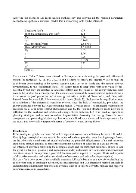
Applying the proposed LU identification methodology and deriving all the required parameters<br />
needed to set up the mathematical model, this summarizing table can be obtained:<br />
Total area (km 2 ) 475<br />
High bio-potentiality area (km 2 ) 124<br />
V 0 0.26<br />
b T 0.1606<br />
M max (Mcal/m 2 /year) 2.3 E+08<br />
B max (Mcal/m 2 /year) 1.5 E+08<br />
U 0 0.02<br />
h 1.96<br />
k 0.75<br />
c 0.0374<br />
V e 0.72<br />
M e 0<br />
Table 2.<br />
The values in Table 2, have been entered in NetLogo model elaborating the proposed <strong>di</strong>fferential<br />
system. In particular, b<br />
T<br />
, h, U<br />
0<br />
, M max , k and c seems to satisfy the inequality (II) so that the<br />
equilibrium correspon<strong>di</strong>ng to he second scenario turns out to be stable and the system evolves<br />
asymptotically to this equilibrium state. The system tends to keep areas with high value of biopotentiality<br />
but they are isolated in landscape pattern and the fluxes of bio-energy between them<br />
seem to be limited. As a consequence, the dynamic evolution of this environmental system shows a<br />
trend toward a good production of bio-energy but with a limited <strong>di</strong>ffusion of it, and, then, with<br />
limited fluxes between LU. A low connectivity index (Table 2), <strong>di</strong>scloses to this equilibrium state<br />
as a solution of the <strong>di</strong>fferential equations system, since the lack of connectivity preju<strong>di</strong>ces the<br />
energy exchange between LU even containing high BTC values areas. The landscape fragmentation<br />
provoked by a large urban sprawl phenomenon and by the rich and structured roads network is<br />
reflected on the confined and obstructed energy fluxes between LU. The need of opportune<br />
planning strategies and actions to reduce fragmentation favouring the energy fluxes between<br />
ecosystems and preserving bio<strong>di</strong>versity, has to be underlined since the actual landscape pattern for<br />
the study area shows a low response in terms of connectivity and energy fluxes.<br />
Conclusions<br />
If the ecological graph is a powerful tool to represent connections efficiency between LU and to<br />
identify high ecological values areas to be protected and compromised ones limiting energy fluxes,<br />
on the other side a mathematical model evaluating the potential effectiveness of natural resources<br />
on the long term, is essential to assess the <strong>di</strong>achronic evolution of landscape as a unique system.<br />
An integrated approach combining the ecological graph and the mathematical model, allows to face<br />
the great challenge of planning and management under sustainable environmental and economical<br />
con<strong>di</strong>tions since it can represent a powerful decision system support to compare effects and impacts<br />
of alternative scenarios and actions (evaluation of new roads and urban development plans).<br />
Not only for a description of the available energy at LU scale but also as a tool for evaluating the<br />
equilibrium trend in landscape evolution, this mathematical and GIS interfaced method can help in<br />
understan<strong>di</strong>ng environment response and dynamic change in time to correctly manage and preserve<br />
natural resources and ecosystems.