- Page 1 and 2:
OHN AN EBASTW 1ABOT
- Page 5 and 6:
BUILDERS OF GREATER BRITAIN EDITED.
- Page 7:
Builders of Greater Britain JOHN AN
- Page 11 and 12:
JOHN AND SEBASTIAN CABOT THE DISCOV
- Page 13 and 14:
PREFACE A GOOD many volumes and ess
- Page 15 and 16:
" " " " PREFACE
- Page 17 and 18:
" " PREFACE xv Sebastian
- Page 19 and 20:
V" CONTENTS CHAPTER I INTRODUC
- Page 21 and 22:
CONTENTS xix CHAPTER XI CABOT S EXA
- Page 23 and 24:
THE UNIVERSITY or John and Sebastia
- Page 25 and 26:
JOHN AND SEBASTIAN CABOT 3 for the
- Page 27 and 28:
JOHN AND SEBASTIAN CABOT 5 rather t
- Page 29 and 30:
JOHN AND SEBASTIAN CABOT 7 safely a
- Page 31 and 32:
JOHN AND SEBASTIAN CABOT 9 As long
- Page 33 and 34:
JOHN AND SEBASTIAN CABOT n way to I
- Page 35 and 36:
JOHN AND SEBASTIAN CABOT 13 end. Wh
- Page 37 and 38:
CHAPTER II INTRODUCTORY SKETCH CONT
- Page 39 and 40:
JOHN AND SEBASTIAN CABOT 17 pious d
- Page 41 and 42:
JOHN AND SEBASTIAN CABOT 19 the sho
- Page 43 and 44:
JOHN AND SEBASTIAN CABOT 21 Classic
- Page 45 and 46:
JOHN AND SEBASTIAN CABOT 23 imagina
- Page 47 and 48:
JOHN AND SEBASTIAN CABOT 25 Ocean w
- Page 49 and 50:
JOHN AND SEBASTIAN CABOT 27 the Wes
- Page 51 and 52:
JOHN AND SEBASTIAN CABOT 29 Santiag
- Page 53 and 54:
JOHN AND SEBASTIAN CABOT 31 majorit
- Page 55 and 56:
CHAPTER III JOHN CABOT S LIFE DOWN
- Page 57 and 58:
JOHN AND SEBASTIAN CABOT 35 from th
- Page 59 and 60:
JOHN AND SEBASTIAN CABOT 37 the doc
- Page 61 and 62:
JOHN AND SEBASTIAN CABOT 39 with th
- Page 63 and 64:
JOHN AND SEBASTIAN CABOT 41 when Di
- Page 65 and 66:
JOHN AND SEBASTIAN CABOT 43 which o
- Page 67 and 68:
JOHN AND SEBASTIAN CABOT 45 from th
- Page 69 and 70:
JOHN AND SEBASTIAN CABOT 47 Thus, t
- Page 71 and 72:
JOHN AND SEBASTIAN CABOT 49 noble a
- Page 73 and 74:
frequented JOHN AND SEBASTIAN CABOT
- Page 75 and 76:
JOHN AND SEBASTIAN CABOT 53 NOTE An
- Page 77 and 78:
JOHN AND SEBASTIAN CABOT 55 dead, I
- Page 79 and 80:
JOHN AND SEBASTIAN CABOT 57 to the
- Page 81 and 82:
< JOHN AND SEBASTIAN CABOT 5
- Page 83 and 84:
JOHN AND SEBASTIAN CABOT 61 (Gran C
- Page 85 and 86:
JOHN AND SEBASTIAN CABOT 63 occupie
- Page 87 and 88:
JOHN AND SEBASTIAN CABOT 65 King he
- Page 89 and 90:
JOHN AND SEBASTIAN CABOT 67 New Wor
- Page 91 and 92:
JOHN AND SEBASTIAN CABOT 69 In this
- Page 93 and 94:
JOHN AND SEBASTIAN CABOT 71 or appr
- Page 95 and 96:
JOHN AND SEBASTIAN CABOT 73 World b
- Page 97 and 98:
JOHN AND SEBASTIAN CABOT 75 * These
- Page 99 and 100:
" Do " JOHN AND SEBASTIAN
- Page 101 and 102:
JOHN AND SEBASTIAN CABOT 79 North-W
- Page 103 and 104:
" JOHN AND SEBASTIAN CABOT 81
- Page 105 and 106:
JOHN AND SEBASTIAN CABOT 83 thence
- Page 107 and 108:
JOHN AND SEBASTIAN CABOT 85 the sec
- Page 109 and 110:
JOHN AND SEBASTIAN CABOT 87 Eastern
- Page 111 and 112:
JOHN AND SEBASTIAN CABOT 89 A word
- Page 113 and 114:
JOHN AND SEBASTIAN CABOT 91 for wha
- Page 115 and 116:
JOHN AND SEBASTIAN CABOT 93 etc. To
- Page 117 and 118:
JOHN AND SEBASTIAN CABOT 95 before
- Page 119 and 120:
i JOHN AND SEBASTIAN CABOT 97 March
- Page 121 and 122:
< < JOHN AND SEBASTIA
- Page 123 and 124:
JOHN AND SEBASTIAN CABOT 101 on Jul
- Page 125 and 126:
JOHN AND SEBASTIAN CABOT 103 The le
- Page 128 and 129:
THE EXGLISH DISCOVERIES l)\ JIAN DK
- Page 130 and 131:
io6 BUILDERS OF GREATER BRITAIN 10.
- Page 132 and 133: io8 BUILDERS OF GREATER BRITAIN nam
- Page 134 and 135: no BUILDERS OF GREATER BRITAIN It w
- Page 136 and 137: CHAPTER VII SEBASTIAN CABOT I HIS L
- Page 138 and 139: ii4 BUILDERS OF GREATER BRITAIN con
- Page 140 and 141: ii6 BUILDERS OF GREATER BRITAIN of
- Page 142 and 143: n8 BUILDERS OF GREATER BRITAIN chie
- Page 144 and 145: izo BUILDERS OF GREATER BRITAIN Sea
- Page 146 and 147: 122 BUILDERS OF GREATER BRITAIN Dec
- Page 148 and 149: 124 BUILDERS OF GREATER BRITAIN men
- Page 150 and 151: 126 BUILDERS OF GREATER BRITAIN Cab
- Page 152 and 153: 128 BUILDERS OF GREATER BRITAIN exc
- Page 154 and 155: 130 BUILDERS OF GREATER BRITAIN hav
- Page 156 and 157: 132 BUILDERS OF GREATER BRITAIN Tha
- Page 158 and 159: 134 BUILDERS OF GREATER BRITAIN pro
- Page 160 and 161: 136 BUILDERS OF GREATER BRITAIN of
- Page 162 and 163: " He 138 BUILDERS OF GREATER B
- Page 164 and 165: 140 BUILDERS OF GREATER BRITAIN Eng
- Page 166 and 167: < i 4 2 BUILDERS OF GREATER
- Page 168 and 169: " Out 1 44 BUILDERS OF GREATER
- Page 170 and 171: 146 BUILDERS OF GREATER BRITAIN smo
- Page 172 and 173: 148 BUILDERS OF GREATER BRITAIN tru
- Page 174 and 175: 150 BUILDERS OF GREATER BRITAIN ano
- Page 176 and 177: 152 BUILDERS OF GREATER BRITAIN you
- Page 178 and 179: 154 BUILDERS OF GREATER BRITAIN Per
- Page 180 and 181: 156 BUILDERS OF GREATER BRITAIN of
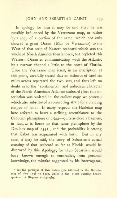
- Page 184 and 185: 160 BUILDERS OF GREATER BRITAIN and
- Page 186 and 187: CHAPTER X SEBASTIAN S RETURN TO ENG
- Page 188 and 189: 164 BUILDERS OF GREATER BRITAIN (Gr
- Page 190 and 191: 1 66 BUILDERS OF GREATER BRITAIN of
- Page 192 and 193: 1 68 BUILDERS OF GREATER BRITAIN la
- Page 194 and 195: 170 BUILDERS OF GREATER BRITAIN alr
- Page 196 and 197: < Whereas 172 BUILDERS OF GR
- Page 198 and 199: 174 BUILDERS OF GREATER BRITAIN wit
- Page 200 and 201: CHAPTER XI CABOT S EXACT EMPLOYMENT
- Page 202 and 203: 1 78 BUILDERS OF GREATER BRITAIN of
- Page 204 and 205: i So BUILDERS OF GREATER BRITAIN An
- Page 206 and 207: i8z BUILDERS OF GREATER BRITAIN bet
- Page 208 and 209: 1 84 BUILDERS OF GREATER BRITAIN wa
- Page 210 and 211: CHAPTER XII THE INSTRUCTIONS DRAWN
- Page 212 and 213: 1 88 BUILDERS OF GREATER BRITAIN c
- Page 214 and 215: 190 BUILDERS OF GREATER BRITAIN not
- Page 216 and 217: 192 BUILDERS OF GREATER BRITAIN com
- Page 218 and 219: 194 BUILDERS OF GREATER BRITAIN to
- Page 220 and 221: 196 BUILDERS OF GREATER BRITAIN tio
- Page 222 and 223: 198 BUILDERS OF GREATER BRITAIN the
- Page 224 and 225: 200 BUILDERS OF GREATER BRITAIN sha
- Page 226 and 227: 202 BUILDERS OF GREATER BRITAIN Sea
- Page 228 and 229: 204 BUILDERS OF GREATER BRITAIN suc
- Page 230 and 231: 2o6 BUILDERS OF GREATER BRITAIN ano
- Page 232 and 233:
208 BUILDERS OF GREATER BRITAIN aut
- Page 234 and 235:
< 210 BUILDERS OF GREATER BR
- Page 236 and 237:
212 BUILDERS OF GREATER BRITAIN Lon
- Page 238 and 239:
214 BUILDERS OF GREATER BRITAIN bee
- Page 240 and 241:
216 BUILDERS OF GREATER BRITAIN in
- Page 242 and 243:
> 218 BUILDERS OF GREATER BR
- Page 245 and 246:
JOHN AND SEBASTIAN CABOT 219 4,000
- Page 247 and 248:
JOHN AND SEBASTIAN CABOT 221 Magell
- Page 249 and 250:
JOHN AND SEBASTIAN CABOT 223 other
- Page 251 and 252:
JOHN AND SEBASTIAN CABOT 225 wherea
- Page 253 and 254:
JOHN AND SEBASTIAN CABOT 227 direct
- Page 255 and 256:
JOHN AND SEBASTIAN CABOT 229 determ
- Page 257 and 258:
JOHN AND SEBASTIAN CABOT 231 eagles
- Page 259 and 260:
JOHN AND SEBASTIAN CABOT 233 who ha
- Page 261 and 262:
JOHN AND SEBASTIAN CABOT 235 garmen
- Page 263 and 264:
JOHN AND SEBASTIAN CABOT 237 astoni
- Page 265 and 266:
JOHN AND SEBASTIAN CABOT 239 his fa
- Page 267 and 268:
JOHN AND SEBASTIAN CABOT 241 Sebast
- Page 269 and 270:
JOHN AND SEBASTIAN CABOT 243 palace
- Page 271 and 272:
JOHN AND SEBASTIAN CABOT 245 Spanis
- Page 273 and 274:
< < JOHN AND SEBASTIA
- Page 275 and 276:
JOHN AND SEBASTIAN CABOT 249 accomp
- Page 277 and 278:
JOHN AND SEBASTIAN CABOT 251 day an
- Page 279 and 280:
JOHN AND SEBASTIAN CABOT 253 by Mic
- Page 281 and 282:
JOHN AND SEBASTIAN CABOT 255 Edward
- Page 283 and 284:
JOHN AND SEBASTIAN CABOT 257 other
- Page 285 and 286:
JOHN AND SEBASTIAN CABOT 259 struct
- Page 287 and 288:
2 * The error in longitude, when fo
- Page 289:
JOHN AND SEBASTIAN CABOT 263 1845.
- Page 292 and 293:
266 APPENDICES (=z Noes), o; Non Si
- Page 294 and 295:
268 APPENDICES him that found the n
- Page 296 and 297:
270 APPENDICES 1498. 10. The new (s
- Page 298 and 299:
35, 272 APPENDICES John Cabot, date
- Page 300 and 301:
274 APPENDICES custumarum et subsid
- Page 302 and 303:
< 276 APPENDICES The MS. is
- Page 304 and 305:
278 APPENDICES In the Public Record
- Page 306 and 307:
280 APPENDICES c higher and lower t
- Page 308 and 309:
282 APPENDICES to England again. He
- Page 310 and 311:
284 APPENDICES 1523. 28. Payment of
- Page 312 and 313:
286 APPENDICES MS. No. 2 in the Cou
- Page 314 and 315:
288 APPENDICES refers to this same
- Page 316 and 317:
290 APPENDICES Public Record Office
- Page 318 and 319:
1789. See pp. 171-4. 292 APPENDIX I
- Page 320 and 321:
: 294 APPENDICES Sebastian and his
- Page 322 and 323:
296 APPENDICES same for April 24, 1
- Page 324 and 325:
298 APPENDICES Portland, 1870, in v
- Page 326 and 327:
300 APPENDICES du XVI. Siecle, Pari
- Page 328 and 329:
< 302 APPENDICES Munich, 187
- Page 330 and 331:
34 APPENDICES 102. Turnbull, W. B.
- Page 333 and 334:
215, INDEX ADAMS, Clement, 251-23.
- Page 335 and 336:
2I " Mantuan INDEX Grajales, D
- Page 337 and 338:
INDEX Andrea (Doge), 37, Steelyard
- Page 339 and 340:
BOOKS FOR RECREATION AND STUDY PUBL
- Page 341 and 342:
" " The " " T.
- Page 344 and 345:
REC D LD NovTrSz


