to launch the PDF document full screen - East Carolina University
to launch the PDF document full screen - East Carolina University
to launch the PDF document full screen - East Carolina University

Create successful ePaper yourself
Turn your PDF publications into a flip-book with our unique Google optimized e-Paper software.
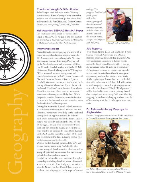
Check out Vaughn’s GISci Poster<br />
Sallie Vaughn <strong>to</strong>ok 3rd place in <strong>the</strong> GISci.org<br />
poster contest. Some of you probably remember<br />
Sallie as one of our excellent grad students from<br />
a few years back. For GISci 2012 Poster Contest<br />
Entries, see www.gisci.org/Contest2012/index.htm<br />
Hall Awarded SEDAAG Best MA Paper<br />
Lin Hall received <strong>the</strong> award for best Masters’<br />
Paper at SEDAAG for his paper and presentation<br />
on Clima<strong>to</strong>logy of <strong>the</strong> Structure, Frequency, and Propagation<br />
of Midlatitude Cyclones that Affect North <strong>Carolina</strong>.<br />
ecology. The<br />
program familiarized<br />
participants<br />
with tides,<br />
waves, geological<br />
classifications of<br />
estuarine systems,<br />
and <strong>the</strong> plants and<br />
animals that call<br />
<strong>the</strong> estuary home.<br />
Exerpted from Magnetic<br />
<strong>East</strong>, Fall 2012.<br />
Randall with turtle hatchling<br />
Internship Report<br />
Alyssa Randall, a senior geography major with a<br />
minor in coastal and marine studies, received a<br />
2012 summer internship through <strong>the</strong> NC State<br />
Government Summer Internship Program led<br />
by <strong>the</strong> Youth Advocacy and Involvement Office.<br />
For 10 weeks Randall worked within <strong>the</strong> DENR<br />
Division of Coastal Management in Wilming<strong>to</strong>n,<br />
NC, as a natural resource management and<br />
outreach assistant for <strong>the</strong> NC Coastal Reserve and<br />
National Estuarine Research Reserve System.<br />
Randall’s job was <strong>to</strong> oversee and lead <strong>the</strong> sea turtle<br />
nesting efforts on Masonboro Island. As part of<br />
<strong>the</strong> North <strong>Carolina</strong> Coastal Reserve, Masonboro<br />
Island is a protected island with no man-made<br />
structures and is only accessible by boat. While<br />
<strong>the</strong> public can visit <strong>the</strong> reserve, its main function<br />
is <strong>to</strong> act as a field research site and provide a haven<br />
for hundreds of different species.<br />
During her internship, Randall led volunteers on<br />
a 10-mile sea turtle nest patrol. When a site was<br />
identified, participants would dig in <strong>the</strong> sand until<br />
<strong>the</strong> <strong>to</strong>p layer of eggs was reached. In order <strong>to</strong><br />
track where turtles may nest in <strong>the</strong> future, a DNA<br />
sample was taken by collecting <strong>the</strong> shell of one<br />
of <strong>the</strong> eggs. The eggs were <strong>the</strong>n recovered with<br />
sand and wire mesh (<strong>to</strong> mainly keep out <strong>the</strong> red<br />
foxes that live on <strong>the</strong> island). In addition, Randall<br />
used a GPS unit <strong>to</strong> mark <strong>the</strong> location of <strong>the</strong> nest<br />
and <strong>to</strong> <strong>document</strong> <strong>the</strong> data, including species type,<br />
predation count and track width.<br />
Once in <strong>the</strong> lab, Randall processed <strong>the</strong> GPS and<br />
created nesting maps using ArcGIS. She also<br />
created a map of fox dens on <strong>the</strong> island, as well as<br />
a map of potential kayak routes that can be used<br />
<strong>to</strong> look for diamondback terrapin.<br />
Randall participated in o<strong>the</strong>r activities during her<br />
internship, including shorebird rescue efforts and<br />
sea turtle necropsies. Her final project as an intern<br />
with <strong>the</strong> North <strong>Carolina</strong> Coastal Reserve was <strong>to</strong><br />
teach an outreach program on <strong>the</strong> <strong>to</strong>pic of estuary<br />
Job Reports<br />
Tyler Bruce, Spring 2012. GIS Techncian 1 with<br />
Stantec (Formally Greenhorn and O’Mara)<br />
Recently I traveled <strong>to</strong> Seattle for field recon. We<br />
were geotagging a coastline in Kitsap county<br />
across <strong>the</strong> Puget Sound from Seattle. It was a 3<br />
day adventure with 342 miles on a boat doing<br />
3D geotagged pictures for engineering models<br />
<strong>to</strong> represent <strong>the</strong> actual coastline. It was a great<br />
opportunity and was fun <strong>to</strong> travel with work.<br />
At <strong>the</strong> beginning of November I accepted a <strong>full</strong><br />
time offer <strong>to</strong> become a GIS Tech 1. I willcontinue<br />
<strong>to</strong> work on projects as well as picking up several<br />
new tasks related <strong>to</strong> <strong>the</strong> FEMA FIRM process I<br />
will be involved in more coastal primary frontal<br />
dune analysis and wave runup/still water flooding<br />
mapping. It has been challenging at times but a lot<br />
of interesting work that is helping me learn new<br />
tasks.<br />
Dr. Palmer-Moloney Deploys <strong>to</strong><br />
Afghanistan<br />
Former Geography instruc<strong>to</strong>r and Ph.D. candidate<br />
in Coastal Resources Management, Dr. Laura<br />
Dr. Palmer-Moloney and Corpsman Daniel Holmberg<br />
hike <strong>to</strong> <strong>the</strong> Helmand River in sou<strong>the</strong>rn Helmand Province.