

Methow River Bull Trout Telemetry Project - U.S. Fish and Wildlife ...
Methow River Bull Trout Telemetry Project - U.S. Fish and Wildlife ...
Methow River Bull Trout Telemetry Project - U.S. Fish and Wildlife ...

Create successful ePaper yourself
Turn your PDF publications into a flip-book with our unique Google optimized e-Paper software.
U.S. <strong>Fish</strong> <strong>and</strong> <strong>Wildlife</strong> Service<br />
Upper Columbia Recovery Unit <strong>Bull</strong> <strong>Trout</strong> <strong>Telemetry</strong> <strong>Project</strong>:<br />
2005 Progress Report for the <strong>Methow</strong> <strong>River</strong> Core Area<br />
________________________________________________<br />
U.S. <strong>Fish</strong> <strong>and</strong> <strong>Wildlife</strong> Service<br />
Mid-Columbia <strong>River</strong> <strong>Fish</strong>ery Resource Office<br />
7501 Icicle Road<br />
Leavenworth, WA 98826
Upper Columbia Recovery Unit<br />
<strong>Bull</strong> <strong>Trout</strong> <strong>Telemetry</strong> <strong>Project</strong>:<br />
2005 Progress Report<br />
for the <strong>Methow</strong> <strong>River</strong> Core Area<br />
Upper Columbia <strong>Bull</strong> <strong>Trout</strong> <strong>Project</strong><br />
FONS # 2001-002<br />
January 25, 2007<br />
Prepared by:<br />
Mark C. Nelson <strong>and</strong> R.D. Nelle<br />
<strong>Fish</strong> Biologists<br />
U.S. <strong>Fish</strong> <strong>and</strong> <strong>Wildlife</strong> Service<br />
Mid-Columbia <strong>River</strong> <strong>Fish</strong>ery Resource Office<br />
7501 Icicle Road<br />
Leavenworth, WA 98826
Disclaimer<br />
The mention of trade names or commercial products in this report does not constitute<br />
endorsement or recommendation for use by the federal government.<br />
The correct citation for this report is:<br />
Nelson, M.C. <strong>and</strong> R.D. Nelle. 2007. Upper Columbia Recovery Unit <strong>Bull</strong> <strong>Trout</strong><br />
<strong>Telemetry</strong> <strong>Project</strong>: 2005 Progress Report for the <strong>Methow</strong> Core Area. January 25, 2007.<br />
U.S. <strong>Fish</strong> <strong>and</strong> <strong>Wildlife</strong> Service, Leavenworth, WA.<br />
i
UPPER COLUMBIA RECOVERY UNIT<br />
BULL TROUT TELEMETRY PROJECT:<br />
2005 PROGRESS REPORT<br />
FOR THE METHOW RIVER CORE AREA<br />
Mark C. Nelson <strong>and</strong> R.D. Nelle<br />
U.S. <strong>Fish</strong> <strong>and</strong> <strong>Wildlife</strong> Service<br />
Mid-Columbia <strong>River</strong> <strong>Fish</strong>ery Resource Office<br />
7501 Icicle Rd.<br />
Leavenworth, WA 98826<br />
Abstract. - During 2005, the Mid-Columbia <strong>River</strong> <strong>Fish</strong>ery Resource Office radio-tracked<br />
adult fluvial bull trout in the <strong>Methow</strong> <strong>River</strong> system. The bull trout were tagged at mid-<br />
Columbia <strong>River</strong> hydroelectric dams by the Douglas <strong>and</strong> Chelan County Public Utility<br />
Districts. Six bull trout were located during mobile telemetry surveys, <strong>and</strong> one radio tag<br />
was recovered. Tagged bull trout migrated to several tributaries, including Twisp <strong>River</strong>,<br />
Wolf Creek, West Fork <strong>Methow</strong> <strong>River</strong> <strong>and</strong> Lost <strong>River</strong>, which all contain known<br />
spawning grounds of bull trout. Upstream migration distances were 68.9 to 88 miles<br />
(110.0 to 141. 6 km) for Wells Dam bull trout <strong>and</strong> 108.3 miles (174.3 km) for the Rocky<br />
Reach bull trout. This study documents the first known migrations of adult fluvial bull<br />
trout from the Columbia <strong>River</strong> to Wolf Creek, West Fork <strong>Methow</strong> <strong>River</strong>, <strong>and</strong> Lost <strong>River</strong><br />
in the <strong>Methow</strong> <strong>River</strong> Core Area.<br />
ii
Table of Contents<br />
Abstract............................................................................................................................... ii<br />
Introduction......................................................................................................................... 1<br />
Study Area .......................................................................................................................... 1<br />
Methods............................................................................................................................... 4<br />
Results................................................................................................................................. 5<br />
Tagging ........................................................................................................................... 5<br />
Radio-telemetry............................................................................................................... 5<br />
Twisp <strong>River</strong>................................................................................................................. 6<br />
West Fork <strong>Methow</strong> <strong>River</strong>............................................................................................ 6<br />
Wolf Creek.................................................................................................................. 6<br />
Lost <strong>River</strong>.................................................................................................................... 6<br />
Dry Reaches.................................................................................................................. 11<br />
Migration distances....................................................................................................... 11<br />
Discussion......................................................................................................................... 11<br />
Acknowledgements........................................................................................................... 13<br />
References......................................................................................................................... 13<br />
List of Tables<br />
Table 1. Tagging location, tag channel <strong>and</strong> code, tagging date, length, <strong>and</strong> weight of<br />
Columbia <strong>River</strong> bull trout that migrated to the <strong>Methow</strong> Core Area in 2005...................... 5<br />
Table 2. Date, method, rivers surveyed, <strong>and</strong> bull trout codes located during radiotelemetry<br />
surveys conducted by MCRFRO in the <strong>Methow</strong> <strong>River</strong> Core Area in 2005. ...... 5<br />
Table 3. Radio-tagged bull trout migration distances from tagging location in Columbia<br />
<strong>River</strong> to furthest upstream location in tributary of <strong>Methow</strong> <strong>River</strong> during 2005............... 11<br />
List of Figures<br />
Figure 1. Map of the Mid-Columbia <strong>River</strong> <strong>and</strong> the 3 core areas of the Upper Columbia<br />
<strong>Bull</strong> <strong>Trout</strong> Recovery Unit. .................................................................................................. 2<br />
Figure 2. Map of the <strong>Methow</strong> <strong>River</strong> Core Area of the Upper Columbia <strong>Bull</strong> <strong>Trout</strong><br />
Recovery Unit. .................................................................................................................... 3<br />
Figure 3. Hitch mounted antennas <strong>and</strong> bike rack setup for mobile tracking. ..................... 4<br />
Figure 4. <strong>Bull</strong> trout locations from radio-telemetry surveys on August 31 <strong>and</strong> September<br />
1, 2005. See Table 2 for areas surveyed on these dates...................................................... 7<br />
Figure 5. <strong>Bull</strong> trout locations from radio-telemetry surveys on September 13, 2005. See<br />
Table 2 for areas surveyed on this date............................................................................... 8<br />
Figure 6. <strong>Bull</strong> trout locations from radio-telemetry surveys on September 27 <strong>and</strong> 28,<br />
2005. See Table 2 for areas surveyed on these dates.......................................................... 9<br />
Figure 7. <strong>Bull</strong> trout locations from radio-telemetry surveys on October 13, 2005. See<br />
Table 2 for areas surveyed on this date............................................................................. 10<br />
Figure 8. Dry river reaches observed during radio-telemetry surveys in the <strong>Methow</strong> <strong>River</strong><br />
system in 2005. ................................................................................................................. 12<br />
iii
Introduction<br />
In 2005, as part of their respective <strong>Bull</strong> <strong>Trout</strong> Monitoring <strong>and</strong> Evaluation Programs, the<br />
Douglas <strong>and</strong> Chelan County Public Utility Districts (DPUD <strong>and</strong> CPUD) implemented<br />
bull trout telemetry projects to monitor adult upstream <strong>and</strong> downstream passage at their<br />
Mid-Columbia <strong>River</strong> dams. Because the focus of these monitoring programs is to<br />
evaluate effects of the hydroelectric dams, minimal tracking was to occur when the<br />
tagged bull trout entered tributaries <strong>and</strong> left the influence of the project areas (CPUD<br />
2005). Therefore, the Mid-Columbia <strong>River</strong> <strong>Fish</strong>ery Resource Office (MCRFRO)<br />
cooperated with the PUDs <strong>and</strong> their contractors to radio track these tagged bull trout in<br />
the tributaries of the Upper Columbia <strong>Bull</strong> <strong>Trout</strong> Recovery Unit. This cooperative effort<br />
will maximize limited resources <strong>and</strong> increase our knowledge of the movements,<br />
spawning migrations, <strong>and</strong> over-wintering locations of fluvial bull trout. In addition, the<br />
initial tracking effort in 2005 will be used as a pilot study to assist in the design <strong>and</strong><br />
planning of a proposed bull trout radio-telemetry study by MCRFRO.<br />
This progress report details the results of the initial telemetry effort by MCRFRO in the<br />
<strong>Methow</strong> <strong>River</strong> watershed in late summer <strong>and</strong> autumn of 2005.<br />
Study Area<br />
The Upper Columbia Recovery Unit contains the mainstem Columbia <strong>River</strong> from the<br />
Yakima <strong>River</strong> upstream to Chief Joseph Dam <strong>and</strong> includes the Wenatchee, Entiat,<br />
Chelan, <strong>Methow</strong>, <strong>and</strong> Okanogan basins (USFWS 2002). The Wenatchee, Entiat, <strong>and</strong><br />
<strong>Methow</strong> <strong>River</strong>s have been identified as core areas in the recovery unit (Figure 1).<br />
The <strong>Methow</strong> <strong>River</strong>, tributary to the Columbia <strong>River</strong> at river mile (rm) 524 (river<br />
kilometer (rkm) 843.3), drains an area of approximately 1,890 mi 2 (4,895 km 2 ). The<br />
<strong>Methow</strong> <strong>River</strong> sub-basin has seven primary sub-watersheds: the Upper <strong>Methow</strong> <strong>River</strong>,<br />
Lost <strong>River</strong>, Early Winters Creek, Chewuch <strong>River</strong>, Middle <strong>Methow</strong> <strong>River</strong>, Twisp <strong>River</strong>,<br />
<strong>and</strong> Lower <strong>Methow</strong> <strong>River</strong> (Figure 2). The tributaries listed on Figure 2 are areas of<br />
assumed historic or current distribution of bull trout in the <strong>Methow</strong> sub-basin (NPCC<br />
2004).<br />
Mean stream discharge is 1,592 ft 3 /s; base flow is 264 ft 3 /s <strong>and</strong> flood stage can be as high<br />
as 46,700 ft 3 /s (Mullan et al. 1992). The lowest stream flows occur in mid-winter<br />
(December to February) <strong>and</strong> early autumn (September) when stream flow is primarily the<br />
result of groundwater discharge. Several reaches dewater <strong>and</strong> flow subsurface at base<br />
flows, including the mainstem <strong>Methow</strong> near the town of Mazama, Goat Creek at the<br />
mouth, <strong>and</strong> Twisp <strong>River</strong> at Poplar Flats Campground.<br />
1
Wells Dam<br />
Chief Joseph Dam<br />
Rocky Reach Dam<br />
Rock Isl<strong>and</strong> Dam<br />
Wenatchee Core Area<br />
Entiat Core Area<br />
<strong>Methow</strong> Core Area<br />
0 10 20 40 Kilometers<br />
Wanapum Dam<br />
Figure 1. Map of the Mid-Columbia <strong>River</strong> <strong>and</strong> the 3 core areas of the Upper Columbia <strong>Bull</strong> <strong>Trout</strong><br />
Recovery Unit.<br />
2
Andrews Creek<br />
Lost <strong>River</strong><br />
Lake Creek<br />
Eureka Creek<br />
Eightmile Creek<br />
Early Winters Creek<br />
Robinson Creek<br />
West Fork <strong>Methow</strong> <strong>River</strong><br />
Cedar Creek<br />
North Creek<br />
Lost <strong>River</strong> Gorge<br />
<strong>Methow</strong> <strong>River</strong><br />
Wolf Creek<br />
Goat Creek<br />
Chewuch <strong>River</strong><br />
Boulder Creek<br />
Twentymile Creek<br />
South Creek<br />
Reynolds Creek<br />
War Creek<br />
Twisp <strong>River</strong><br />
Eagle Creek<br />
Canyon Creek<br />
West Fork Buttermilk Creek<br />
Beaver Creek<br />
Frazer Creek<br />
Libby Creek<br />
Crater Creek<br />
Foggy Dew Creek<br />
South Fork Gold Creek<br />
0 5 10 20 Kilometers<br />
Figure 2. Map of the <strong>Methow</strong> <strong>River</strong> Core Area of the Upper Columbia <strong>Bull</strong> <strong>Trout</strong> Recovery Unit.<br />
3
Methods<br />
Adult fluvial bull trout were radio-tagged at Wells Dam by DPUD (LGL 2006) <strong>and</strong> at<br />
Rocky Reach Dam <strong>and</strong> Rock Isl<strong>and</strong> Dam by CPUD (CPUD 2006a). The radio tags used<br />
at Wells Dam were manufactured by Grant Engineering <strong>and</strong> transmitted on frequency<br />
148.320 MHz (channel 201). Tags used at Rocky Reach <strong>and</strong> Rock Isl<strong>and</strong> Dams were<br />
Lotek model MCFT-3A transmitters <strong>and</strong> transmitted on frequency 148.580 MHz<br />
(channel 214). Fixed telemetry sites were set up <strong>and</strong> maintained by the PUDs at the dams<br />
<strong>and</strong> tributary entrances. After the tagged bull trout entered the <strong>Methow</strong> <strong>River</strong>, MCRFRO<br />
used a Lotek SRX400 telemetry receiver <strong>and</strong> mobile telemetry techniques to locate the<br />
fish. The large size of the watershed precluded a single survey of the entire core area so<br />
different areas were covered during each survey session. Surveys were conducted on foot<br />
<strong>and</strong> by mountain bike with whip <strong>and</strong> h<strong>and</strong> held yagi antennae, by truck with hitch<br />
mounted dual yagi 4-element antennae (Figure 3), <strong>and</strong> by airplane with wing mounted<br />
dual yagi antennae. Locations were recorded with a Garmin GPSmap76 unit or placed by<br />
h<strong>and</strong> on 7.5 minute USGS topographic maps. GPS waypoints were downloaded into<br />
MapTech Terrain navigator <strong>and</strong> the marker files were exported into Desktop GIS<br />
ArcView v9.0 for creation of maps.<br />
Figure 3. Hitch mounted antennas <strong>and</strong> bike rack setup for mobile tracking.<br />
4
Results<br />
Tagging<br />
Six adult fluvial bull trout were radio-tagged at Wells Dam by DPUD in 2005 (LGL<br />
2005). Thirty-one bull trout were radio-tagged by CPUD at Rocky Reach Dam <strong>and</strong> 9 at<br />
Rock Isl<strong>and</strong> Dam in 2005 (BioAnalysts 2006a). Five of the DPUD bull trout (codes 2, 4,<br />
6, 8, <strong>and</strong> 10) were detected by the fixed receiver site at the mouth of the <strong>Methow</strong> <strong>River</strong><br />
(LGL 2005). Code 12 was not detected at any of the fixed receiver sites maintained by<br />
DPUD. Two CPUD bull trout (codes 3 <strong>and</strong> 31) were detected at the mouth of the <strong>Methow</strong><br />
<strong>River</strong> (BioAnalysts 2006a). Lengths of the bull trout that used the <strong>Methow</strong> Core Area<br />
ranged from 430-680 mm; weights ranged from 840-2910 g (Table 1).<br />
Table 1. Tagging location, tag channel <strong>and</strong> code, tagging date, length, <strong>and</strong> weight of Columbia <strong>River</strong><br />
bull trout that migrated to the <strong>Methow</strong> Core Area in 2005.<br />
Length<br />
Agency Site Channel Code Tagging date<br />
Weight<br />
(g)<br />
(mm)<br />
DPUD Wells 1 2 26-May-05 530 --<br />
DPUD Wells 1 4 2-Jun-05 560 2200<br />
DPUD Wells 1 6 3-Jun-05 680 2910<br />
DPUD Wells 1 8 7-Jun-05 430 840<br />
DPUD Wells 1 10 7-Jun-05 510 1490<br />
DPUD Wells 1 12 28-Jun-05 -- --<br />
CPUD Rock Isl<strong>and</strong> 14 3 30-May-05 450 1244<br />
CPUD Rocky Reach 14 31 31-May-05 520 1586<br />
Data: BioAnalysts (2006b)<br />
Radio-telemetry<br />
MCRFRO radio-tracked the tagged bull trout in the <strong>Methow</strong> <strong>River</strong> Core Area during 6<br />
sessions in the late summer <strong>and</strong> autumn of 2005. Each session covered different sections<br />
of the watershed <strong>and</strong> 6 tagged bull trout were located (Table 2). Five bull trout (codes 2,<br />
4, 6, 10, <strong>and</strong> 12) were DPUD study fish <strong>and</strong> 1 bull trout (code 31) was a CPUD study<br />
fish. <strong>Bull</strong> trout DPUD code 8 <strong>and</strong> CPUD code 3 were not located.<br />
Table 2. Date, method, rivers surveyed, <strong>and</strong> bull trout codes located during radio-telemetry surveys<br />
conducted by MCRFRO in the <strong>Methow</strong> <strong>River</strong> Core Area in 2005.<br />
Session Dates Obs Method <strong>River</strong>s Surveyed 1 Codes<br />
1 8/31-9/1 MN,BG Truck, Foot M,T,B,C,Wl,E,WFl,Lol 2,4,6,12<br />
2 9/12-13 MN,DC Truck, Bike, Foot M,G,W,WF,Lol 2,31<br />
3 9/27 BKR Flight M,C,La,WF,Lo,W 2,10,31<br />
4 9/27-28 MN,DC Truck, Foot M,G,T,B,Gld 4,6,12<br />
5 10/12-13 MN,DC Truck, Foot M,G,T,B,WFl,Lol 2,10,6,12<br />
6 11/16 MN,DC Truck, Foot M,T,WFl,Lol none<br />
Note 1: B- Buttermilk Cr., C- Chewuch R., E- Early Winters Cr., G- Goat Cr., Gld- Gold Cr., La- Lake Cr.,<br />
Lo- Lost R., Lol- lower Lost R., M-entire mainstem <strong>Methow</strong> R., T- Twisp R., W- Wolf Cr, Wl- lower Wolf<br />
Cr., WF- West Fork <strong>Methow</strong> R, WFl- lower West Fork <strong>Methow</strong> R.<br />
5
Tagged bull trout were located in 4 tributaries of the <strong>Methow</strong> <strong>River</strong>: Twisp <strong>River</strong>, West<br />
Fork <strong>Methow</strong> <strong>River</strong>, Wolf Creek, <strong>and</strong> Lost <strong>River</strong> (Figures 4, 5, 6, 7). No tagged fish were<br />
located in the mainstem <strong>Methow</strong> <strong>River</strong>.<br />
Twisp <strong>River</strong>-Three tagged bull trout were located in Twisp <strong>River</strong>. On August 31, during<br />
truck tracking from the Twisp <strong>River</strong> Road, codes 4, 6, <strong>and</strong> 12 were located between rm<br />
18.5 (rkm 29.8) <strong>and</strong> rm 20.2 (rkm 32.5) (Figure 4). On September 28, during truck<br />
tracking, bull trout code 4 was located at rm 12.5 (rkm 20.1), downstream of Buttermilk<br />
Creek, <strong>and</strong> we walked in <strong>and</strong> recorded exact positions for code 6 at rm 20.2 (rkm 32.5)<br />
<strong>and</strong> code 12 at rm 20.8 (rkm 33.5) (Figure 6). Code 6 was holding in a large pool along<br />
with at least one untagged fluvial bull trout <strong>and</strong> code 12 was in a small pool in the<br />
vicinity of at least 3 bull trout redds on the spawning grounds downstream of Reynolds<br />
Creek. On October 13, codes 6 <strong>and</strong> 12 were located from the truck downstream of<br />
Buttermilk Creek, between rm 12.1 (rkm 19.5) <strong>and</strong> rm 12.5 (rkm 20.1) (Figure 7). Code 4<br />
was not found <strong>and</strong> had presumably exited the Twisp <strong>River</strong>. On November 16, no codes<br />
were found in the Twisp, <strong>and</strong> codes 6 <strong>and</strong> 12 had also presumably exited the river.<br />
West Fork <strong>Methow</strong> <strong>River</strong>-One tagged bull trout was located in West Fork <strong>Methow</strong> <strong>River</strong>.<br />
On September 1, Code 2 was located from the truck at the end of spur 60 of FR 5400. We<br />
walked trail 480 <strong>and</strong> determined code 2 was upstream of Rattlesnake Creek (Figure 4),<br />
but did not attempt an exact position or visual of the fish. On September 13, we tracked<br />
from mountain bikes on trail 480 to Leap Creek, <strong>and</strong> code 2 was in the same general area<br />
(Figure 5). During the flight survey on September 27, code 2 was located in the same area<br />
(Figure 6). On October 13, we recovered the tag in the same vicinity (Figure 7). No<br />
carcass or body parts were discovered. The tag was covered with algae <strong>and</strong> apparently<br />
had been lying on the bottom for a period of time, but we do not known if the bull trout<br />
shed the tag or died. The recovery site was more than a mile (2 km) downstream of <strong>Trout</strong><br />
Creek, the lower start of the USFS bull trout spawning ground survey index reach.<br />
Wolf Creek-One tagged bull trout was located in Wolf Creek. On September 13, we<br />
walked the Wolf Creek Trail <strong>and</strong> found CPUD code 31 downstream of North Fork Wolf<br />
Creek (Figure 5). On September 19, it was located in the same area during a spawning<br />
ground survey (Judy Delavergne, USFWS, pers. comm.). Code 31 was still in the area<br />
during the flight on September 27 (Figure 6), the last telemetry survey of this section of<br />
Wolf Creek.<br />
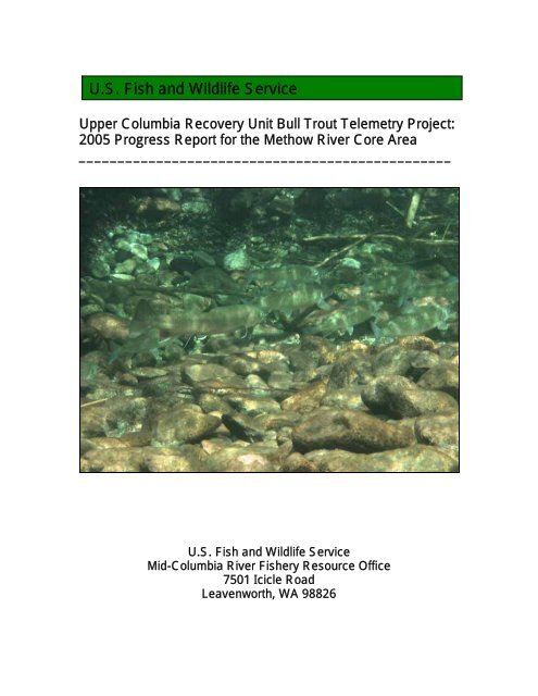
Lost <strong>River</strong>-One tagged bull trout was located in Lost <strong>River</strong>. On September 27, code 10<br />
was located during the flight survey in the Lost <strong>River</strong> Gorge, downstream of Monument<br />
Creek (Figure 6). On October 13, code 10 was located 50m downstream of the County<br />
Road 9140 bridge (Figure 7). We snorkeled <strong>and</strong> took pictures of code 10 (see cover<br />
photo); it appeared healthy <strong>and</strong> was with 3 untagged adult fluvial bull trout <strong>and</strong> a school<br />
of 25 mountain whitefish. An additional 4 untagged adult fluvial bull trout <strong>and</strong> another<br />
school of 25 mountain whitefish were observed 50m upstream in a pool under the bridge.<br />
We did not locate the signal of code 10 on the November 16 survey. We drove FR 5400<br />
<strong>and</strong> then walked the lower Lost <strong>River</strong> <strong>and</strong> the <strong>Methow</strong> <strong>River</strong> to the dry reach,<br />
approximately 2 miles (3.2 km) downstream, but we did not pick up the signal.<br />
6
Lo st <strong>River</strong><br />
2<br />
West Fork <strong>Methow</strong> <strong>River</strong><br />
Lost <strong>River</strong> Gorge<br />
Early Winters Creek<br />
Chewuch <strong>River</strong><br />
Wolf Creek<br />
4<br />
6<br />
12<br />
Twisp R<br />
iver<br />
M ethow <strong>River</strong><br />
0 5 10 20 Kilometers<br />
<strong>Bull</strong> <strong>Trout</strong> Radio Locations<br />
Aug 31 <strong>and</strong> Sept 1, 2005<br />
Wells<br />
Figure 4. <strong>Bull</strong> trout locations from radio-telemetry surveys on August 31 <strong>and</strong> September 1, 2005. See<br />
Table 2 for areas surveyed on these dates.<br />
7
Lo st <strong>River</strong><br />
2<br />
West Fork <strong>Methow</strong> <strong>River</strong><br />
Lost <strong>River</strong> Gorge<br />
Early Winters Creek<br />
Wolf Creek<br />
31<br />
Chewuch <strong>River</strong><br />
Twisp R<br />
iver<br />
M ethow <strong>River</strong><br />
0 5 10 20 Kilometers<br />
<strong>Bull</strong> <strong>Trout</strong> Radio Locations<br />
September 13, 2005<br />
Wells<br />
Figure 5. <strong>Bull</strong> trout locations from radio-telemetry surveys on September 13, 2005. See Table 2 for<br />
areas surveyed on this date.<br />
8
Lo st <strong>River</strong><br />
West Fork <strong>Methow</strong> <strong>River</strong><br />
2<br />
10<br />
Lost <strong>River</strong> Gorge<br />
Early Winters Cree k<br />
Wolf Creek<br />
31<br />
Chewuch <strong>River</strong><br />
12<br />
6<br />
4<br />
Twisp R<br />
iver<br />
M ethow <strong>River</strong><br />
0 5 10 20 Kilometers<br />
<strong>Bull</strong> <strong>Trout</strong> Radio Locations<br />
September 27 <strong>and</strong> 28, 2005<br />
Wells<br />
Figure 6. <strong>Bull</strong> trout locations from radio-telemetry surveys on September 27 <strong>and</strong> 28, 2005. See Table<br />
2 for areas surveyed on these dates.<br />
9
Chewu ch <strong>River</strong><br />
Lo st <strong>River</strong><br />
Tag Recovered<br />
2<br />
West Fork <strong>Methow</strong> <strong>River</strong><br />
10<br />
Lost <strong>River</strong> Gorge<br />
Early Winters Cree k<br />
Wolf Creek<br />
126<br />
Twisp R<br />
iver<br />
<strong>Methow</strong> R<br />
iver<br />
0 5 10 20 Kilometers<br />
<strong>Bull</strong> <strong>Trout</strong> Radio Locations<br />
October 13, 2005<br />
Wells<br />
Figure 7. <strong>Bull</strong> trout locations from radio-telemetry surveys on October 13, 2005. See Table 2 for<br />
areas surveyed on this date.<br />
10
Dry Reaches<br />
During surveys, we documented 3 dry reaches in the <strong>Methow</strong> <strong>River</strong> system (Figure 8).<br />
The Twisp <strong>River</strong> was dry at Poplar Flats campground at rm 21.9 (rkm 35.2), <strong>and</strong> had<br />
been since at least mid-August, according to the campground host. The <strong>Methow</strong> <strong>River</strong><br />
was dry in the vicinity of Mazama, <strong>and</strong> eventually the river went dry from Weeman<br />
Bridge to river mile 71 (rkm 114.3). Goat Creek was dry from the mouth to the bridge on<br />
County Road 1163. Thus, the upper Twisp <strong>River</strong> <strong>and</strong> the upper <strong>Methow</strong> <strong>River</strong> tributaries<br />
of West Fork <strong>Methow</strong>, Lost <strong>River</strong>, Early Winter Creek, <strong>and</strong> Goat Creek were isolated<br />
from the mainstem <strong>Methow</strong> by dry reaches in late summer <strong>and</strong> fall of 2005.<br />
Migration distances<br />
The upstream migration distances for 5 bull trout tagged at Wells Dam ranged from 68.9<br />
to 88 miles (110.0 to 141. 6 km) (Table 3), with an average distance of 76.2 miles (122<br />
km). The one CPUD bull trout we located migrated 108.3 miles (174.3 km) from Rocky<br />
Reach Dam to Wolf Creek (Table 3).<br />
Table 3. Radio-tagged bull trout migration distances from tagging location in Columbia <strong>River</strong> to<br />
furthest upstream location in tributary of <strong>Methow</strong> <strong>River</strong> during 2005.<br />
Code Tagged at: Tributary migrated to Distance migrated upstream<br />
2 Wells West Fork <strong>Methow</strong> <strong>River</strong> 85.5 mi (137.6 km)<br />
4 Wells Twisp <strong>River</strong> 68.9 mi (110.9 km)<br />
6 Wells Twisp <strong>River</strong> 68.9 mi (110.9 km)<br />
10 Wells Lost <strong>River</strong> 88 mi (141.6 km)<br />
12 Wells Twisp <strong>River</strong> 69.5 mi (111.8 km)<br />
31 Rocky Reach Wolf Creek 108.3 mi (174.3 km)<br />
Discussion<br />
Fluvial bull trout tagged during previous radio-telemetry studies in the Columbia <strong>River</strong><br />
migrated to the mainstem <strong>Methow</strong> <strong>River</strong> or the Twisp <strong>River</strong> (BioAnalysts 2004, Nelson<br />
2004). This study documents the first known migrations of bull trout from the Columbia<br />
<strong>River</strong> into the upper tributaries of the <strong>Methow</strong> <strong>River</strong>. This study also confirms that<br />
Columbia <strong>River</strong> bull trout visit some of the known spawning reaches in those tributaries,<br />
as indicated by the presence of the tagged bull trout on the Wolf Creek spawning<br />
grounds. The code 2 tag we recovered in the West Fork <strong>Methow</strong> <strong>River</strong> was located just 2<br />
km downstream of the spawning ground index reach, in an area where pre-spawning<br />
fluvial bull trout have been observed congregating in pools (Dave Hopkins, USFS, pers.<br />
comm.).<br />
The code 2 tag was apparently on the bottom for some time before we recovered it, <strong>and</strong><br />
we do not know if the bull trout died or shed the tag. Because a large amount of effort is<br />
needed to recover carcasses <strong>and</strong> tags we suggest that future telemetry studies use radio<br />
11
L ost <strong>River</strong><br />
Lost <strong>River</strong> Gorge<br />
Dry Reach <strong>Methow</strong> <strong>River</strong><br />
West Fork <strong>Methow</strong> <strong>River</strong><br />
Early Winters Creek<br />
Dry Reach Goat Creek<br />
Chewuch <strong>River</strong><br />
Wolf Creek<br />
Dry Reach Twisp <strong>River</strong><br />
Twisp <strong>River</strong><br />
<strong>Methow</strong> Riv er<br />
0 5 10 20 Kilometers<br />
Figure 8. Dry river reaches observed during radio-telemetry surveys in the <strong>Methow</strong> <strong>River</strong> system in<br />
2005.<br />
12
transmitters with motion switches to indicate cessation of movement <strong>and</strong> increase the<br />
likelihood that a carcass <strong>and</strong> clues to mortality are discovered. Expulsion of tags has been<br />
documented in other studies by snorkel observations of an expulsion wound on a bull<br />
trout near the vicinity of a shed tag (Mendel et al. 2003) <strong>and</strong> a motion switch could<br />
increase the probability of this type of confirmation.<br />
Dry reaches are a common <strong>and</strong> natural occurrence in the <strong>Methow</strong> watershed <strong>and</strong> several<br />
of the known spawning grounds are upstream of these reaches. The response <strong>and</strong> survival<br />
of post-spawning adult bull trout to these isolations should be monitored in order to<br />
determine their impact on recovery numbers of bull trout (Nelson 2004).<br />
Acknowledgements<br />
We appreciate the support of Bao Le of Douglas PUD <strong>and</strong> Steven Hemstrom of Chelan<br />
PUD; this first year of study would not have been possible without the tagging <strong>and</strong><br />
monitoring programs of the utilities. Information on tagged bull trout movements into the<br />
<strong>Methow</strong> <strong>River</strong> was provided by Bryan Nass of LGL, Ltd, <strong>and</strong> additional information was<br />
provided by John Stevenson <strong>and</strong> Denny Snyder of BioAnalysts, Inc. Field assistance was<br />
provided by USFWS <strong>Fish</strong> Technicians David Conlin <strong>and</strong> Brett Gaddis. The aerial survey<br />
was conducted by USFWS <strong>Fish</strong> Biologist Barbara Kelly-Ringel.<br />
On the cover: photograph of adult fluvial bull trout tag code 10 with a school of mountain<br />
whitefish in the lower Lost <strong>River</strong>. USFWS photograph by David Conlin.<br />
References<br />
BioAnalysts. 2004. Movement of bull trout within the Mid-Columbia <strong>River</strong> <strong>and</strong><br />
tributaries 2001-2004-final. Prepared by BioAnalysts, Inc., Boise Idaho, for<br />
Chelan, Douglas, <strong>and</strong> Grant PUDs. May 26, 2004.<br />
BioAnalysts. 2006a. <strong>Bull</strong> trout radiotelemetry monitoring associated with up <strong>and</strong><br />
downstream passage through Rocky Reach <strong>and</strong> Rock Isl<strong>and</strong> Dams <strong>and</strong> reservoirs,<br />
2005. Appendix A in Reasonable <strong>and</strong> prudent measures <strong>and</strong> associated terms <strong>and</strong><br />
conditions for protection of bull trout. Annual Report April 15, 2006. FERC<br />
<strong>Project</strong> No. 2145 <strong>and</strong> No. 943. Public Utility District No. 1 of Chelan County,<br />
Wenatchee, Washington.<br />
BioAnalysts. 2006b. 2006-Comprehensive Tagging File-final. Unpublished database.<br />
CPUD (Chelan Public Utility District). 2005. Rocky Reach bull trout management plan.<br />
Final. September 23, 2005. Rocky Reach Hydroelectric <strong>Project</strong>. FERC <strong>Project</strong><br />
No. 2145. Public Utility District No. 1 of Chelan County. Wenatchee WA.<br />
LGL (LGL Limited Environmental Research Associates). 2005. Memo to DCPUD re:<br />
bull trout travel analysis #3, dated 21 July 2005.<br />
13
LGL. 2006. Wells <strong>Bull</strong> <strong>Trout</strong> Monitoring <strong>and</strong> Management Plan. 2005 Annual Report.<br />
Wells Hydroelectric <strong>Project</strong>. FERC No. 2149. March 30, 2006.<br />
Mendel, G., C. Fulton, <strong>and</strong> R. Weldert. 2003. An investigation into the migratory<br />
behavior of bull trout (Salvelinus confluentus) in the Touchet <strong>River</strong> basin.<br />
Washington Department of <strong>Fish</strong> <strong>and</strong> <strong>Wildlife</strong>, Dayton, WA.<br />
Mullan, J., K. Williams, G. Rhodus, T. Hillman, <strong>and</strong> J. McIntyre. 1992. Production <strong>and</strong><br />
Habitats in Mid-Columbia <strong>River</strong> Tributary Streams. U.S. <strong>and</strong> <strong>Wildlife</strong> Service<br />
Monograph I. 489 pp.<br />
Nelson, M.C. 2004. Movements, habitat use, <strong>and</strong> mortality of adult fluvial bull trout<br />
isolated by seasonal subsurface flow in the Twisp <strong>River</strong>, WA. U.S. <strong>Fish</strong> <strong>and</strong><br />
<strong>Wildlife</strong> Service, Leavenworth, WA.<br />
NPCC (Northwest Power <strong>and</strong> Conservation Council). 2004. <strong>Methow</strong> Subbasin Plan.<br />
Appendix C of Final Report. November 2004.<br />
USFWS (U.S. <strong>Fish</strong> <strong>and</strong> <strong>Wildlife</strong> Service) 2002. Chapter 22, Upper Columbia Recovery<br />
Unit, Washington. 113 p. in U.S. <strong>Fish</strong> <strong>and</strong> <strong>Wildlife</strong> Service. <strong>Bull</strong> <strong>Trout</strong><br />
(Salvelinus confluentus) Draft Recovery Plan. Portl<strong>and</strong>, Oregon.<br />
Personal Communications<br />
Delavergne, J. 2005. USFWS, Central Washington Field Office. Email re: BT Wolf<br />
Creek. September 21, 2005.<br />
Hopkins, D. 2005. USFS, <strong>Methow</strong> Valley Ranger District, Okanogan Wenatchee<br />
National Forest. Conversation re: holding pools for pre-spawning bull trout in the<br />
West Fork <strong>Methow</strong> <strong>River</strong>. September 1, 2005.<br />
14
U. S. <strong>Fish</strong> <strong>and</strong> <strong>Wildlife</strong> Service<br />
Mid-Columbia <strong>River</strong> <strong>Fish</strong>ery Resource Office<br />
7501 Icicle Road<br />
Leavenworth, WA<br />
January 2007


