Yorkshire East Riding & Kingston upon Hull ... - Hearth Tax Online
Yorkshire East Riding & Kingston upon Hull ... - Hearth Tax Online
Yorkshire East Riding & Kingston upon Hull ... - Hearth Tax Online

You also want an ePaper? Increase the reach of your titles
YUMPU automatically turns print PDFs into web optimized ePapers that Google loves.
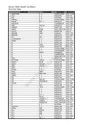
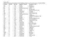
<strong>Yorkshire</strong> <strong>East</strong> <strong>Riding</strong> & <strong>Kingston</strong> <strong>upon</strong> <strong>Hull</strong> Statistical Analysis<br />
These tables provide a breakdown of the household and hearth number data derived from the<br />
manuscripts, E179/205/504, <strong>East</strong> <strong>Riding</strong>, 1672L and E179/205/505, <strong>Kingston</strong> Upon <strong>Hull</strong>,<br />
1673L.<br />
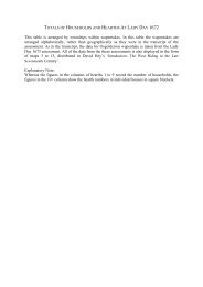
The data is listed in alphabetical order, by wapentake / hundred, then by constabulary / ward,<br />
and has been tabulated into collection units solely on the basis of the information provided by<br />
the manuscript.<br />
Modern place names have been used throughout and uncertainties are indicated with a ?<br />
The first four columns relate to the number of households.<br />
CH = Chargeable households<br />
NC = Non-Chargeable households<br />
ill = number of entries for which the hearth number is illegible. These entries are included in<br />
the household number totals, as it is clear there was a household accounted for, but are not<br />
included in the hearth number data as the number of hearts cannot be identified.<br />
The remaining columns relate to the number of households with a given number of hearths.<br />
The one-hearth column lists the total number of one-hearth households, both chargeable and<br />
non-chargeable. The number of non-chargeable one-hearth households can be derived from<br />
consulting the total number of non-chargeable households.<br />
The two-hearth entries are split into two columns:<br />
2 = total number of two-hearth households, both chargeable and non-chargeable<br />
2NC = indicates the number of that total that were listed as non-chargeable<br />
Entries for households with ten or more hearths are listed in two columns<br />
10+ = the number of households listed with ten or more hearths<br />
List of 10+ = the figures given in square brackets indicate the exact number of hearths given<br />
for each household.<br />
The total number of hearths, rather than households, is provided in the Total column.<br />
Totals marked with ** are derived from the calculated total of all legible hearths, rather than<br />
the scribal total provided on the manuscript.
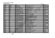
<strong>Yorkshire</strong> <strong>East</strong> <strong>Riding</strong>, 1672L<br />
E179/205/504<br />
Households<br />
<strong>Hearth</strong>s<br />
All CH NC ill 1 2 2NC 3 4 5 6 7 8 9 10+ List of 10+ Total<br />
Beverely Wapentake<br />
Beckside and Barleyholme 45 31 14 21 8 10 3 1 1 1 [10] 103<br />
Flemingate 47 25 22 26 7 6 4 1 1 1 1 102<br />
Keldgate and Minster Moorgate 96 51 45 67 12 7 4 4 1 1 162<br />
Molescroft 41 29 12 32 5 1 1 2 [10, 11] 78<br />
Newbegin and Lairgate 50 30 20 26 6 5 3 4 3 1 1 1 [12] 131<br />
Norwood, Hengate and Walkergate 66 46 20 33 9 7 8 2 2 2 1 2 166<br />
Saturday Market 79 65 14 22 19 11 10 7 5 3 2 235<br />
Thearne, Woodmansey and Beverley Parks 46 44 2 28 12 4 1 1 75<br />
Tickton, <strong>Hull</strong> Bridge, Storkhill and Sandholme 22 16 6 13 7 1 1 35<br />
Toll Gavel 46 36 10 19 11 7 1 3 4 1 113<br />
Wednesday Market 97 77 20 41 16 16 10 6 1 3 3 1 [14] 256<br />
Weel 18 17 1 14 4 22<br />
Within North Bar 59 46 13 24 8 11 5 3 3 2 1 2 [14, 20] 182<br />
Without North Bar 36 27 9 19 6 1 4 2 3 1 85<br />
Beverely TOTAL 748 540 208 385 130 86 53 34 23 14 11 5 7 1745
<strong>Yorkshire</strong> <strong>East</strong> <strong>Riding</strong>, 1672L<br />
E179/205/504<br />
Households<br />
<strong>Hearth</strong>s<br />
All CH NC ill 1 2 2NC 3 4 5 6 7 8 9 10+ List of 10+ Total<br />
Buckrose Wapentake<br />
Acklam with Leavening 74 58 16 67 7 81<br />
Birdsall 70 31 39 65 3 1 1 [10] 91<br />
Bugthorpe 45 33 12 39 2 2 1 1 55<br />
Burythorpe 20 14 6 18 1 1 23<br />
Cowlam 14 9 5 12 1 1 17<br />
Duggleby 20 12 8 19 1 21<br />
<strong>East</strong> Heslerton 35 28 7 33 2 37<br />
<strong>East</strong> Lutton and West Lutton 36 24 12 32 3 1 41<br />
Eddlethorpe 10 10 0 8 1 1 15<br />
Fimber 16 9 7 12 4 20<br />
Firby 22 7 15 21 1 26<br />
Fridaythorpe 24 16 8 22 2 26<br />
Garrowby 2 2 0 1 1 3<br />
Helperthorpe 18 14 4 15 2 1 23<br />
Howsham 29 27 2 23 3 1 1 1 [24] 61<br />
Kennythorpe with Thornthorpe 17 12 5 13 3 1 23<br />
Kirby Grindalythe 23 18 5 19 1 1 1 1 36<br />
Kirby Underdale 30 25 5 28 1 1 38<br />
Kirkham 6 6 0 4 1 1 10<br />
Knapton 52 43 9 51 1 59<br />
Langton 41 25 16 39 1 1 [14] 57<br />
Leppington 24 14 10 22 1 1 31<br />
Menethorpe 14 12 2 11 3 17<br />
North Grimston 26 15 11 19 2 2 1 1 1 46<br />
Norton with Welham (total) 46 26 20 38 4 2 1 1 [17] 72<br />
(Norton) 42 22 20 37 3 1 1 [17] 61<br />
(Welham) 4 4 0 1 1 1 1 11<br />
Rillington 63 48 15 54 6 1 1 1 85<br />
Scagglethorpe 28 19 9 [11] 17 14**<br />
Scampston 49 38 11 48 1 50
<strong>Yorkshire</strong> <strong>East</strong> <strong>Riding</strong>, 1672L<br />
E179/205/504<br />
Households<br />
<strong>Hearth</strong>s<br />
All CH NC ill 1 2 2NC 3 4 5 6 7 8 9 10+ List of 10+ Total<br />
Scrayingham 27 22 5 22 4 1 36<br />
Settrington 69 50 19 56 8 2 2 1 85<br />
Sherburn 57 42 15 53 3 1 62<br />
Skirpenbeck 47 31 16 36 8 1 1 1 [15] 74<br />
Sledmere 52 28 24 43 6 1 2 75<br />
Thirkleby 9 3 6 9 9<br />
Thixendale with Raisthorpe 18 13 5 13 3 [1] 2 26<br />
Thorpe Bassett 22 17 5 17 2 1 1 1 33<br />
Towthorpe 11 8 3 9 2 13<br />
Weaverthorpe 38 24 14 36 2 40<br />
West Heslerton 39 27 12 35 1 1 1 1 [13] 57<br />
Westow 36 30 6 27 6 2 1 [12] 57<br />
Wetwang 50 21 29 40 6 4 64<br />
Wharram le Street and Wharram Percy 25 14 11 19 2 3 1 38<br />
Wintringham 63 51 12 57 3 1 1 1 [10] 80<br />
Yedingham 14 10 4 10 2 2 22<br />
Buckrose TOTAL 1431 986 445 1232 109 33 15 9 6 4 3 1 8 1835
<strong>Yorkshire</strong> <strong>East</strong> <strong>Riding</strong>, 1672L<br />
E179/205/504<br />
Households<br />
<strong>Hearth</strong>s<br />
All CH NC ill 1 2 2NC 3 4 5 6 7 8 9 10+ List of 10+ Total<br />
Dickering Wapentake<br />
Bessingby and <strong>East</strong>on 22 22 0 14 2 2 3 1 44<br />
Binnington 19 7 12 18 1 20<br />
Boynton 31 17 14 26 1 2 1 1 [23] 62<br />
Bridlington 232 136 96 151 30 27 16 6 1 1 [12] 405<br />
Bridlington Quay 120 94 26 71 29 5 7 4 3 1 [11] 221<br />
Brigham 37 32 5 31 3 1 1 1 49<br />
Buckton and Bempton 73 42 31 60 9 1 1 1 1 98<br />
Burton Agnes 49 34 15 41 2 3 2 1 [32] 96<br />
Burton Fleming 51 27 24 48 2 1 61<br />
Butterwick and Boythorpe 21 16 5 20 1 23<br />
Carnaby 48 30 18 43 3 1 1 58<br />
Filey 77 17 60 69 5 2 1 89<br />
Flamborough 101 42 59 87 8 2 1 1 1 1 [12] 141<br />
Flixton 36 26 10 35 1 37<br />
Folkton and Flotmanby 35 26 9 32 2 1 45<br />
Foston on the Wolds 39 28 11 32 6 1 47<br />
Foxholes 20 11 9 18 1 1 25<br />
Fraisthorpe with Auburn 37 22 15 30 2 1 3 1 60<br />
Ganton and Potter Brompton 46 22 24 43 1 2 [10, 13] 71<br />
Garton on the Wolds 47 31 16 36 7 2 2 66<br />
Grindale 23 17 6 22 1 26<br />
Haisthorpe 28 23 5 26 1 1 37<br />
Harpham and Gransmoor 70 50 20 61 8 1 80<br />
Hilderthorpe 3 3 0 0 2 1 12<br />
Hunmanby 167 110 57 141 14 9 1 1 1 [11] 218<br />
Kelk with Gembling 40 33 7 32 5 1 2 58<br />
Kilham 111 80 31 77 16 13 4 1 170<br />
Langtoft 57 36 21 49 5 2 1 69<br />
Lowthorpe and Cattleholmes 28 23 5 22 5 1 [15] 47<br />
Muston 57 47 10 47 7 1 1 1 73
<strong>Yorkshire</strong> <strong>East</strong> <strong>Riding</strong>, 1672L<br />
E179/205/504<br />
Households<br />
<strong>Hearth</strong>s<br />
All CH NC ill 1 2 2NC 3 4 5 6 7 8 9 10+ List of 10+ Total<br />
Nafferton with Pockthorpe 104 83 21 92 8 1 1 2 131<br />
Reighton 39 30 9 30 7 2 50<br />
Rudston and Thorpe and Caythorpe 64 32 32 54 2 3 2 1 1 1 97<br />
Ruston Parva 30 20 10 24 1 3 1 1 47<br />
Sewerby and Marton 53 28 25 41 7 4 1 74<br />
Speeton 25 16 9 21 3 1 30<br />
Staxton with Spital 27 18 9 25 2 29<br />
Thornholme 26 19 7 26 26<br />
Thwing with Octon 40 35 5 32 4 2 1 1 59<br />
Wansford 43 28 15 38 2 1 2 53<br />
Willerby 20 13 7 18 1 1 27<br />
Wold Newton 36 28 8 31 3 2 43<br />
Dickering TOTAL 2232 1454 778 1814 214 98 44 23 13 8 5 4 9 3174
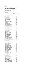
<strong>Yorkshire</strong> <strong>East</strong> <strong>Riding</strong>, 1672L<br />
E179/205/504<br />
Households<br />
<strong>Hearth</strong>s<br />
All CH NC ill 1 2 2NC 3 4 5 6 7 8 9 10+ List of 10+ Total<br />
Harthill Bainton Beacon<br />
Aike 14 14 0 14 14<br />
Bainton 46 30 16 40 3 1 1 1 61<br />
Beswick 35 21 14 29 2 3 1 [15] 57<br />
Bracken 4 4 0 2 2 6<br />
Cranswick 85 76 9 71 7 3 1 1 1 1 [11] 121<br />
<strong>East</strong>burn 4 1 3 4 4<br />
Elmswell 12 9 3 6 3 1 1 1 33<br />
Great Driffield and Little Driffield (total) 159 83 76 138 15 2 2 1 1 [11] 199<br />
(Great Driffield) 71 71 0 51 14 2 2 1 1 [11] 110<br />
(Little Driffield) 12 12 0 11 1 13<br />
(Great and Little Driffield exempt) 76 0 76 76 76<br />
Holme on the Wolds 19 19 0 14 4 1 27<br />
Hutton 43 37 6 41 2 45<br />
Kilnwick 42 35 7 36 3 2 1 [20] 68<br />
Kirkburn 24 10 14 19 2 2 1 33<br />
Lockington 71 55 16 61 3 4 2 1 96<br />
Lund 52 43 9 33 12 [1] 4 1 1 1 [15] 95<br />
Middleton on the Wolds 50 39 11 40 3 5 1 1 75<br />
Neswick 25 16 9 22 2 1 29<br />
North Dalton 58 30 28 55 1 1 1 [10] 70<br />
Rotsea 6 6 0 3 1 2 11<br />
Scorborough 19 19 0 14 2 1 1 1 [24] 51<br />
Skerne 36 25 11 29 4 2 1 52<br />
Southburn 19 12 7 16 1 1 1 26<br />
Sunderlandwick 9 5 4 8 1 12<br />
Tibthorpe 22 15 7 20 2 24<br />
Warter 83 53 30 77 3 1 1 1 [14] 102<br />
Watton 64 57 7 50 4 5 1 2 1 1 [16] 109<br />
Harthill Bainton Beacon TOTAL 1001 714 287 842 81 37 10 11 4 5 0 2 9 1420
<strong>Yorkshire</strong> <strong>East</strong> <strong>Riding</strong>, 1672L<br />
E179/205/504<br />
Households<br />
<strong>Hearth</strong>s<br />
All CH NC ill 1 2 2NC 3 4 5 6 7 8 9 10+ List of 10+ Total<br />
Harthill Holme Beacon<br />
Aughton 34 28 6 29 3 [1] 1 1 45<br />
Bielby 41 36 5 38 3 44<br />
Breighton 22 22 0 8 8 4 1 1 48<br />
Bubwith with Harlthorpe 60 50 10 45 11 [1] 3 1 81<br />
<strong>East</strong> Cottingwith 41 35 6 32 8 1 51<br />
<strong>East</strong>horpe 12 12 0 11 1 17<br />
Ellerton 56 47 9 53 2 1 [13] 69<br />
Everingham 57 45 12 52 2 2 1 [24] 86<br />
Goodmanham 29 23 6 21 4 2 1 1 48<br />
Harswell 8 8 0 4 2 1 1 15<br />
Hayton 45 31 14 37 4 1 1 1 1 [10] 71<br />
Holme on Spalding Moor 149 149 0 126 12 2 4 2 2 1 [16] 210<br />
Laytham with Foggathorpe 19 19 0 13 3 1 1 1 [11] 40<br />
Londesborough 23 23 0 16 2 3 1 1 [21] 54<br />
Market Weighton 141 121 20 104 20 11 2 2 2 207<br />
Melbourne with Storwood 73 57 16 68 4 1 83<br />
Newsholme with Brind 27 27 0 18 8 1 37<br />
Seaton Ross 77 70 7 66 8 1 1 1 94<br />
Shipton Thorpe 54 42 12 46 6 1 1 65<br />
Spaldington 44 42 2 34 7 1 1 1 [14] 69<br />
Thorpe le Street 5 5 0 3 1 1 10<br />
Willitoft with Gribthorpe 11 11 0 5 4 1 1 24<br />
Wressle with Loftsome 28 28 0 13 8 4 2 1 58<br />
Harthill Holme Beacon TOTAL 1056 931 125 842 130 40 17 7 7 1 3 2 7 1526
<strong>Yorkshire</strong> <strong>East</strong> <strong>Riding</strong>, 1672L<br />
E179/205/504<br />
Households<br />
<strong>Hearth</strong>s<br />
All CH NC ill 1 2 2NC 3 4 5 6 7 8 9 10+ List of 10+ Total<br />
Harthill Hunsley Beacon<br />
Bentley 7 7 0 2 3 1 1 20<br />
Bishop Burton 69 63 6 49 12 3 3 2 [10, 20] 124<br />
Brantingham Thorpe 10 10 0 6 2 1 1 [11] 24<br />
Broomfleet 36 31 5 31 5 41<br />
Cherry Burton 58 45 13 40 14 1 1 1 1 89<br />
Cottingham (total) 291 265 26 175 75 39 13 9 3 1 1 1 555<br />
(Derringham) 4 4 0 0 3 1 9<br />
(Eppleworth) 10 10 0 3 5 1 1 20<br />
(Finkle Street) 20 20 0 14 3 2 1 30<br />
(Hallgate) 46 46 0 19 10 11 1 2 1 1 1 109<br />
(<strong>Hull</strong> Bank) 27 27 0 12 11 1 1 2 51<br />
(Newgate) 71 71 0 37 19 8 3 4 131<br />
(Newland) 30 30 0 12 8 6 2 1 1 66<br />
(Northgate) 57 57 0 26 16 9 4 2 113<br />
(Cottingham exempt) 26 0 26 52 26<br />
Drewton 13 9 4 11 1 1 17<br />
Elloughton with Brough 70 60 10 54 8 5 1 2 102<br />
Etton 68 43 25 48 14 2 1 1 1 1 [15] 115<br />
Everthorpe 21 21 0 17 4 29<br />
Faxfleet 14 14 0 8 5 1 21<br />
Hotham 49 46 3 43 2 2 1 1 68<br />
Leconfield with Arram 66 50 16 51 10 [1] 2 1 1 1 93<br />
Little Weighton 34 28 6 21 7 2 1 2 1 64<br />
North Cave 98 85 13 77 12 5 3 1 [26] 154<br />
North Cliffe 22 13 9 21 1 30<br />
North Newbald 48 48 0 40 4 3 1 63<br />
Risby 6 6 0 4 1 1 [15] 21<br />
Sancton with Houghton 50 35 15 43 5 2 59<br />
Sculcoates 15 15 0 5 4 1 3 1 1 39<br />
Skidby 41 38 3 24 16 1 62
<strong>Yorkshire</strong> <strong>East</strong> <strong>Riding</strong>, 1672L<br />
E179/205/504<br />
Households<br />
<strong>Hearth</strong>s<br />
All CH NC ill 1 2 2NC 3 4 5 6 7 8 9 10+ List of 10+ Total<br />
South Cave 113 106 7 79 16 13 1 1 1 1 1 [14] 187<br />
South Cliffe 27 22 5 26 1 28<br />
South Dalton 44 36 8 32 9 2 1 68<br />
South Newbald 28 28 0 21 3 2 1 1 48<br />
Walkington 28 28 0 20 7 1 39<br />
Wauldby 5 5 0 3 1 1 9<br />
Harthill Hunsley Beacon TOTAL 1331 1157 174 951 237 86 31 19 14 3 5 4 7 2169
<strong>Yorkshire</strong> <strong>East</strong> <strong>Riding</strong>, 1672L<br />
E179/205/504<br />
Households<br />
<strong>Hearth</strong>s<br />
All CH NC ill 1 2 2NC 3 4 5 6 7 8 9 10+ List of 10+ Total<br />
Harthill Wilton Beacon<br />
Allerthorpe 31 27 4 23 5 1 1 1 48<br />
Barmby on the Moor 73 62 11 66 3 [1] 2 1 1 90<br />
Bishop Wilton 94 73 21 84 2 3 4 1 [12] 125<br />
Bolton 25 23 2 22 2 1 30<br />
Burnby 29 21 8 23 2 1 1 1 1 49<br />
<strong>East</strong> Stamford Bridge 18 14 4 12 5 1 25<br />
Fangfoss 25 25 0 21 2 1 1 32<br />
Full Sutton 23 12 11 19 2 2 31<br />
Great Givendale 13 12 1 11 2 15<br />
Grimthorpe 1 1 0 0 1 8<br />
High Catton 31 27 4 27 1 1 2 40<br />
Huggate 39 15 24 [3] 35 1 [1] 37<br />
Kilnwick Percy 10 9 1 7 1 1 1 [13] 26<br />
Low Catton 31 22 9 27 2 1 1 41<br />
Meltonby 10 9 1 8 1 1 13<br />
Millington with Little Givendale 36 24 12 33 1 [1] 1 1 45<br />
Newton <strong>upon</strong> Derwent 36 32 4 34 1 1 40<br />
Nunburnholme 30 20 10 26 2 1 1 40<br />
Pocklington 168 125 43 125 24 11 3 2 1 1 1 [11] 255<br />
Sutton <strong>upon</strong> Derwent 57 50 7 50 3 1 3 77<br />
Thornton with Mill House 49 39 10 48 1 51<br />
Waplington 13 9 4 13 13<br />
Wilberfoss 44 31 13 38 4 [2] 1 1 55<br />
Yapham 21 17 4 19 2 23<br />
Youlthorpe with Gawthorpe 20 15 5 18 2 22<br />
Harthill Wilton Beacon TOTAL 927 714 213 789 70 25 20 4 7 4 1 1 3 1231
<strong>Yorkshire</strong> <strong>East</strong> <strong>Riding</strong>, 1672L<br />
E179/205/504<br />
Households<br />
<strong>Hearth</strong>s<br />
All CH NC ill 1 2 2NC 3 4 5 6 7 8 9 10+ List of 10+ Total<br />
Holderness Middle Bailiwick<br />
Aldbrough and <strong>East</strong> Newton 87 57 30 74 5 [3] 2 4 1 1 [12] 128<br />
Benningholme 17 17 0 13 1 1 1 1 27<br />
Bilton 26 26 0 22 2 1 1 36<br />
Burton Pidsea 65 56 9 53 9 3 80<br />
Coniston 15 13 2 12 2 1 20<br />
Danthorpe 8 8 0 4 3 1 19<br />
Drypool 14 14 0 4 5 2 1 1 1 38<br />
Ellerby 26 26 0 16 8 1 1 [11] 47<br />
Elstronwick 34 24 10 26 7 1 44<br />
Fitling 24 24 0 13 9 1 1 39<br />
Flinton with Etherdwick 28 28 0 18 7 1 1 1 50<br />
Fosham and Carlton 9 9 0 3 3 1 1 1 [11] 27<br />
Ganstead 12 11 1 4 5 2 1 27<br />
Garton with Grimston 22 18 4 12 4 4 1 1 43<br />
Hedon 92 92 0 26 28 18 9 6 4 1 233<br />
Hilston 5 5 0 0 2 1 2 18<br />
Humbleton 20 15 5 14 3 1 1 1 [11] 38<br />
Lelley 20 13 7 14 3 2 1 30<br />
Marfleet 31 31 0 15 5 5 5 1 65<br />
Marton 14 14 0 6 7 1 24<br />
Owstwick 17 15 2 8 8 1 28<br />
Preston 106 68 38 [22] 60 14 6 1 1 1 1 [11] 117**<br />
Roos 57 49 8 48 7 1 1 70<br />
South Skirlaugh 17 17 0 12 3 2 26<br />
Southcoates 12 12 0 5 4 3 29<br />
Sproatley 37 29 8 27 6 3 1 54<br />
Stoneferry 48 47 1 28 8 [1] 4 5 2 1 93<br />
Sutton on <strong>Hull</strong> 83 68 15 66 10 3 2 2 121<br />
Swine 30 30 0 19 6 2 2 1 [13] 60<br />
Thirtleby 10 10 0 8 2 12
<strong>Yorkshire</strong> <strong>East</strong> <strong>Riding</strong>, 1672L<br />
E179/205/504<br />
Households<br />
<strong>Hearth</strong>s<br />
All CH NC ill 1 2 2NC 3 4 5 6 7 8 9 10+ List of 10+ Total<br />
Tunstall 33 33 0 25 6 2 47<br />
Wawne (total) 77 77 0 51 18 4 2 1 1 [16] 128<br />
(Wawne) 68 68 0 47 15 2 2 1 1 [16] 112<br />
(Liberty of St Peter) 9 9 0 4 3 2 16<br />
Waxholme 7 7 0 1 2 3 1 18<br />
West Newton 16 16 0 9 5 1 1 [40] 65<br />
Wyton 12 12 0 9 1 1 1 [10] 25<br />
Holderness Middle Bailiwick TOTAL 1131 991 140 725 214 73 46 20 12 7 2 1 9 1809
<strong>Yorkshire</strong> <strong>East</strong> <strong>Riding</strong>, 1672L<br />
E179/205/504<br />
Households<br />
<strong>Hearth</strong>s<br />
All CH NC ill 1 2 2NC 3 4 5 6 7 8 9 10+ List of 10+ Total<br />
Holderness South Bailiwick<br />
Burstwick 66 53 13 42 12 6 4 1 1 [12] 119<br />
Easington 93 57 36 71 15 2 1 1 1 1 1 [10] 140<br />
Halsham 36 32 4 26 9 1 47<br />
Hollym 60 37 23 51 3 2 1 2 1 83<br />
Holmpton 43 29 14 32 5 4 1 1 64<br />
Keyingham 72 59 13 52 13 [3] 5 2 106<br />
Kilnsea 24 24 0 10 9 3 1 1 46<br />
Ottringham 82 57 25 66 11 3 1 1 106<br />
Ottringham Marsh 18 18 0 15 1 2 23<br />
Out Newton 14 14 0 12 2 16<br />
Owthorne 28 18 10 24 2 2 34<br />
Patrington 119 75 44 83 21 8 3 2 1 1 184<br />
Paull with members 48 48 0 26 13 5 1 1 1 1 97<br />
Ploughland and Thorpe Hill 12 12 0 6 4 1 1 [12] 29<br />
Rimswell 24 24 0 19 4 1 31<br />
Ryhill and Camerton 35 30 5 22 7 3 2 1 59<br />
Skeffling 36 31 5 22 10 3 1 55<br />
South Frodingham 11 11 0 6 2 1 1 1 [12] 30<br />
Thorngumbald 26 26 0 22 2 1 1 33<br />
Weeton 21 21 0 17 3 1 26<br />
Welwick 56 37 19 45 8 [1] 2 1 73<br />
Winestead 24 24 0 18 4 1 1 [17] 48<br />
Withernsea 33 21 12 32 1 34<br />
Holderness South Bailiwick TOTAL 981 758 223 719 161 55 17 12 6 3 2 1 5 1483
<strong>Yorkshire</strong> <strong>East</strong> <strong>Riding</strong>, 1672L<br />
E179/205/504<br />
Households<br />
<strong>Hearth</strong>s<br />
All CH NC ill 1 2 2NC 3 4 5 6 7 8 9 10+ List of 10+ Total<br />
Holdernesse North Bailiwick<br />
Arnold, and Rowton, and North Skirlaugh 42 42 0 35 2 5 54<br />
Atwick 25 25 0 14 9 2 38<br />
Barmston 34 26 8 25 2 5 1 1 [10] 58<br />
Beeford 83 63 20 74 6 1 1 1 100<br />
Bewholme and Arram 40 40 0 27 7 3 2 1 67<br />
Bonwick and Dunnington 12 10 2 5 5 1 1 28<br />
Brandesburton 85 66 19 75 7 2 1 105<br />
Catfoss 9 9 0 6 2 1 [10] 20<br />
Catwick 33 24 9 31 1 1 36<br />
Eske 3 3 0 2 1 11<br />
Goxhill 13 10 3 10 2 1 17<br />
Great Cowden and Little Cowden 36 28 8 29 5 2 47<br />
Great Hatfield and Little Hatfield 29 21 8 22 5 1 1 40<br />
Hempholme and Heigholme 17 17 0 13 4 21<br />
Hornsea 97 83 14 58 24 10 3 1 1 159<br />
Leven 66 49 17 56 7 2 1 81<br />
Lissett 17 17 0 13 1 3 27<br />
Long Riston 39 39 0 36 2 1 43<br />
North Frodingham 85 64 21 68 11 3 2 1 113<br />
Rise 30 25 5 19 7 2 1 1 [13] 56<br />
Rolston with Mappleton 50 37 13 44 3 2 1 62<br />
Routh 45 37 8 39 4 1 1 [10] 61<br />
Seaton and Wassand 27 20 7 16 7 3 1 [10] 52<br />
Sigglesthorne 27 17 10 21 1 3 1 1 46<br />
Skipsea 69 43 26 59 5 3 1 1 87<br />
Ulrome 46 32 14 39 4 1 1 1 [10] 65<br />
Upton 27 27 0 20 5 1 1 39<br />
Withernwick 56 56 0 45 10 1 68<br />
Holdernesse North Bailiwick TOTAL 1142 930 212 901 148 48 20 9 4 2 2 2 6 0 1601
<strong>Yorkshire</strong> <strong>East</strong> <strong>Riding</strong>, 1672L<br />
E179/205/504<br />
Households<br />
<strong>Hearth</strong>s<br />
All CH NC ill 1 2 2NC 3 4 5 6 7 8 9 10+ List of 10+ Total<br />
Howdenshire<br />
? 19 11 8 14 2 [2] 1 2 31<br />
Asselby 60 55 5 38 16 3 2 1 92<br />
Balkholme 15 15 0 11 3 1 21<br />
Barmby on the Marsh 92 72 20 71 19 1 1 111<br />
Belby 18 17 1 12 5 1 25<br />
Bellasize 30 30 0 21 7 1 1 42<br />
Blacktoft 39 39 0 23 14 1 1 58<br />
Brantingham 22 22 0 10 7 4 1 42<br />
Cavil 11 11 0 6 3 1 1 23<br />
Cotness 12 12 0 [5] 5 1 1 [16] 24**<br />
<strong>East</strong>rington 71 53 18 57 9 [2] 3 2 94<br />
Ellerker 55 45 10 34 13 6 1 1 88<br />
Gilberdyke 61 58 3 52 7 [1] 1 1 76<br />
Howden (total) 204 157 47 101 39 27 15 12 4 1 2 430<br />
(Bridge Gate) 101 54 47 65 13 [3] 12 3 5 1 1 1 188<br />
(Hail Gate) 44 44 0 [3] 19 11 5 4 2 82**<br />
(Market Place) 31 31 0 2 6 9 6 5 2 1 110<br />
(Flat Gate) 28 28 0 15 9 1 2 1 50<br />
Kilpin 26 19 7 17 5 1 1 1 1 46<br />
Knedlington 47 32 15 [7] 29 7 3 1 56**<br />
Laxton 34 24 10 29 4 1 44<br />
Melton 21 14 7 15 1 1 3 1 [10] 42<br />
Portington 9 8 1 7 1 1 23<br />
Saltmarshe 30 30 0 10 16 2 1 1 57<br />
Scalby 23 21 2 22 1 24<br />
Skelton 38 33 5 24 10 3 1 61<br />
Thorpe 7 7 0 3 3 1 12<br />
Walkington 37 37 0 28 7 2 50<br />
Welton 76 54 22 54 10 9 2 1 [11] 120<br />
Howdenshire TOTAL 1057 876 181 693 208 71 36 15 7 4 4 1 3 1530
<strong>Yorkshire</strong> <strong>East</strong> <strong>Riding</strong>, 1672L<br />
E179/205/504<br />
Households<br />
<strong>Hearth</strong>s<br />
All CH NC ill 1 2 2NC 3 4 5 6 7 8 9 10+ List of 10+ Total<br />
Ouze & Darwent<br />
Barlby 54 42 12 29 19 2 1 1 2 [11, 11] 104<br />
Brackenholme with Wood Hall 13 11 2 6 2 3 2 31<br />
Cliffe with Lund 72 55 17 50 15 1 5 1 110<br />
Deighton 40 31 9 31 6 2 1 [14] 63<br />
Dunnington 74 55 19 64 7 [1] 1 1 1 94<br />
Elvington 48 34 14 41 4 1 1 1 65<br />
Escrick 78 59 19 59 10 [1] 4 2 2 1 [17] 131<br />
Fulford 67 54 13 41 13 6 3 2 2 125<br />
Grimston 14 12 2 6 6 1 1 [13] 35<br />
Hemingbrough 59 53 6 32 17 [1] 7 1 1 1 106<br />
Heslington 59 55 4 44 8 3 2 1 1 [16] 99<br />
Kelfield 30 29 1 17 7 2 2 1 1 65<br />
Kexby 23 19 4 19 1 2 1 [12] 42<br />
Menthorpe 11 9 2 5 2 3 1 22<br />
Naburn 38 30 8 19 10 4 2 1 1 1 81<br />
North Duffield 59 55 4 47 7 [2] 3 1 1 82<br />
Osgodby 26 26 0 15 7 2 1 1 44<br />
Riccall 129 105 24 94 20 9 3 2 1 201<br />
Skipwith 48 41 7 36 7 [1] 2 2 1 72<br />
South Duffield 37 33 4 24 9 1 1 1 1 64<br />
Stillingfleet 49 46 3 39 4 1 3 1 1 [10] 79<br />
Thorganby with West Cottingwith (total) 76 50 26 60 11 2 1 2 [10, 11] 113<br />
(Thorganby) 20 20 0 14 3 1 1 1 [11] 38<br />
(West Cottingwith) 56 30 26 46 8 1 1 [10] 75<br />
West Stamford Bridge 16 12 4 9 4 2 1 31<br />
Wheldrake 115 100 15 96 12 2 3 1 1 153<br />
Ouze & Darwent TOTAL 1235 1016 219 883 207 61 36 10 8 8 5 7 10 2012<br />
Grand Total 14272 11067 3205 10776 1909 713 345 173 111 63 43 31 83 21535
<strong>Yorkshire</strong>, <strong>Kingston</strong> <strong>upon</strong> <strong>Hull</strong>, 1673L<br />
E179/205/505<br />
Households<br />
<strong>Hearth</strong>s<br />
All CH NC [ill] 1 2 2NC 3 4 5 6 7 8 9 10+ List of 10+ Total<br />
<strong>Kingston</strong> Upon <strong>Hull</strong> Town<br />
Austin Ward First Part 86 86 0 15 19 10 8 13 8 4 2 4 3 [10, 10, 11] 339<br />
Austin Ward Second Part 116 116 0 28 40 14 14 9 4 5 1 1 [13] 331<br />
Humber Ward First Part 84 84 0 14 22 16 14 6 4 5 1 2 [10, 15] 285<br />
Humber Ward Second Part 401 140 261 44 46 23 14 7 3 2 1 [11] 600<br />
North Ward First Part 55 55 0 [8] 4 13 8 5 5 2 2 4 1 3 [13, 15, 17] **211<br />
North Ward Second Part 60 60 0 14 16 5 13 6 2 2 2 0 185<br />
St Mary Ward First Part 67 67 0 10 18 6 8 10 6 6 1 2 [10, 13] 255<br />
St Mary Ward Second Part 55 55 0 9 19 6 4 7 3 2 1 4 [11, 11, 13, 17] 208<br />
Trinity Ward First Part 92 92 0 10 20 20 14 11 7 4 1 1 4 [10, 10, 10, 11] 349<br />
Trinity Ward Second Part 116 116 0 14 37 22 13 9 6 6 1 1 7 [10, 10, 11, 12, 12, 13, 13] 427<br />
Whitefryer Ward First Part 96 96 0 18 23 16 15 8 5 3 1 7 [10, 10, 10, 10, 10, 12, 16] 349<br />
Whitefryer Ward Second Part 145 145 0 56 45 14 12 6 7 4 1 0 344<br />
<strong>Kingston</strong> Upon <strong>Hull</strong> Town TOTAL 1373 1112 261 236 318 160 134 97 57 45 14 9 34 3672<br />
<strong>Kingston</strong> Upon <strong>Hull</strong> County<br />
Anlaby 31 30 1 14 7 4 2 1 1 1 [10] 72<br />
Hessle 98 71 27 39 11 [1] 14 3 1 1 1 1 0 170<br />
Kirk Ella 32 25 7 15 4 2 3 1 0 53<br />
North Ferriby 33 33 0 20 8 1 1 2 1 [10] 67<br />
Swanland 35 32 3 17 11 3 1 0 56<br />
West Ella 13 11 2 6 1 3 1 0 23<br />
Willerby 34 34 0 21 10 1 1 1 0 54<br />
<strong>Kingston</strong> Upon <strong>Hull</strong> County TOTAL 276 236 40 132 52 28 11 3 3 4 0 1 2 495<br />
Grand Total 1649 1348 301 368 370 188 145 100 60 49 14 10 36 4167